
Forest City City Zoning Code
CHAPTER 3
- ZONING DISTRICTS
3.1 - Interpretation.
3.1.1 Definition of Zoning.
(A)
Zoning is the process by which an area is divided into various districts, each of which is specifically intended for different uses and intensity of uses and within which the use of land and buildings, the height and dimension of buildings, the size of required yards and the population density are regulated.
(B)
Further, the regulations are to be made with reasonable consideration, among other things, to the character of the district and its unique suitability for particular uses, and with a view to conserving the value of buildings and encouraging the most appropriate use of land throughout the town's jurisdiction.
3.1.2 Zoning District Authority.
(A)
Pursuant to the authority established in NCGS 160D-702, the Town, as shown on the Zoning Map accompanying this Ordinance, is hereby divided into districts which shall be governed by all of the uniform use and dimensional requirements of this Ordinance.
(B)
The town's territorial jurisdiction is divided into districts, or zones, of any number, shape and area that may be deemed best suited to carry out the purposes of Article 7 of NCGS Chapter 160D. Within those districts, the municipality may regulate and restrict the erection, construction, reconstruction, alteration, repair, or use of buildings, structures, or land.
3.1.3 Zoning Map.
(A)
For the purposes of this Ordinance, the Town of Forest City is hereby divided into zoning districts whose locations and boundaries are shown on the Official Zoning Map for the Town of Forest City which is hereby adopted by reference and declared to be a part of this Ordinance.
(B)
This Zoning Map and all the notations, references and all amendments thereto, and other information shown thereon are hereby made a part of this Ordinance the same as if such information set forth on the map were all fully described and set out herein. The Zoning Map properly attested is on file in the Town Hall and is available for inspection by the public.
(C)
In accordance with NCGS 160D-105, the Administrator shall maintain in paper and/or digital format the official Zoning Map and any state or federal maps incorporated by reference into the Zoning Map, in accordance with NCGS 160D-105. Upon notification by the Town Board that a zoning change has been made, the Administrator shall make the necessary changes on the Official Zoning Map. Current and prior zoning maps shall be maintained for public inspection.
(D)
Where uncertainty exists as to the boundaries of any district shown on the Official Zoning Map, the Administrator shall employ the following rules of interpretation.
(1)
Centerline. Where a boundary line lies within and follows a street or alley right-of-way, a railroad right-of-way, or utility easement, the boundary shall be construed to be in the center of such street or alley right-of-right, railroad right-of-way, or utility easement forming the boundary between two (2) separate zoning districts. If such right-of-way is abandoned or removed from dedication, the district boundaries shall be construed as following the centerline of the abandoned or vacated street or utility easement.
(2)
Edge Line. Where a boundary line follows the edge of a street or alley right-of-way, a railroad right-of-way, or utility easement, the boundary shall be construed to be on the edge of such street or alley right-of-way, railroad right-of-way, or utility easement. If such a street or alley right-of-way, railroad right-of-way, or utility easement forming the boundary between two (2) separate zoning districts is abandoned or removed from dedication, the district boundaries shall be construed as following the edge of the abandoned or vacated street or utility easement.
(3)
Lot Line. Boundaries indicated as approximately following lot lines shall be construed as following such lot lines. In the event that a district boundary line divides a lot or tract, each part of the lot or tract so divided shall be used in conformity with the regulations established by this Ordinance for the district in which said part is located.
(4)
Town Limits. Boundaries indicated as approximately following town limits or extraterritorial boundary lines shall be construed as following the town limits or extraterritorial boundary lines.
(5)
Watercourses. Boundaries indicated as approximately following the centerlines of streams, rivers, canals, lakes, or other bodies of water shall be construed to follow such center lines.
(6)
Extensions. Boundaries indicated as parallel to or extensions of street or alley rights-of-way, utility easements, lot lines, city limits, county lines, or extraterritorial boundaries shall be so construed.
(7)
Scaling. In a case where a district boundary does not coincide with any boundary lines as above and no distances are described by specific ordinance; the boundary shall be determined by the use of the scale appearing on the map.
(8)
Where the Administrator determines that physical features existing on the ground, or actual property lines or other man-made boundary lines used to depict zoning district boundaries, are different than those shown on the Official Zoning Map, the Board of Adjustment shall have the authority to interpret Zoning district boundaries.
3.1.4 District and Permitted Use Interpretation.
Each zoning district has uses permitted by right, uses permitted with supplemental requirements and special uses. Tables are shown for each district placing uses under one (1) of the three (3) categories. In addition to the individual district tables, is a detailed permitted uses table showing the uses allowed in each district. The following describes the processes of each of the three (3) categories that the uses are subject to:
(A)
Permitted by Right. Administrative review and approval subject to district provisions and other applicable requirements only.
(B)
Permitted with Supplemental Requirements. Administrative review and approval subject to district provisions, other applicable requirements outlined in Chapter 4.
(C)
Conditional Uses. Board of Adjustment review and approval of Special Use Permit subject to district provisions, other applicable requirements and conditions of approval. Some Special Uses may also be subject to supplemental requirements outlined in Chapter 4.
3.1.5 Other Requirements.
Refer to all other local, state and federal requirements.
(Ord. of 6-20-16(2); Ord. No. FCUDO-2021-03, att., 6-21-21)
3.2 - Zoning Districts.
Zoning districts are created to provide comprehensive land use regulations throughout Forest City. There are eleven (11) base zoning districts that provide for a variety of uses that are appropriate to the character of the areas in which they are located. For the purpose of this Ordinance, Forest City is hereby divided into the following base zoning districts. These districts shall comply with all of the general and specific requirements of this Ordinance. The districts also have corresponding Conditional Zoning districts set forth in Section 3.5.
3.2.1 R-20 Low Density Residential/Agricultural District.
The R-20 Low Density Residential District is established as a district in which the principal use of the land is for low density residential or agricultural uses and to provide and protect low density residential areas for those desiring that type of development. The R-20 district also permits associated public and private facilities typically associated with such districts.
3.2.2 R-15 Low Density Residential District.
The R-15 Low Density Residential District is established as a district in which the principal use of the land is for low-density single-family residential purposes. This district is further intended to protect existing single-family neighborhoods in Forest City from incompatible land uses. It is also the intent of this district to allow for certain types of non-residential community facilities that would not be detrimental to the residential character of the district.
3.2.3 R-8 Medium Density Residential District.
The R-8 Medium Density Residential District is established as a district in which the principal use of land is for medium density single and multi-family residential purposes. This district thus allows for a variety of residential uses in areas where the traffic circulation pattern would accommodate medium density residential development. It is also the intent of this district to allow for certain type of nonresidential community facilities that would not be detrimental to the residential character of the district.
3.2.4 R-6 High Density Residential District.
The R-6 High Density Residential District is established as a district in which the principal use of land is for high-density residential purposes. This district thus allows the highest residential density in the town in a variety of residential uses in areas where traffic circulation patterns can accommodate such densities. It is also the intent of this district to allow for certain types of nonresidential community facilities and services that would not be detrimental to the residential character of the district.
3.2.5 OI Office and Institutional District.
The Office and Institutional District is a district in which the principal use of land is for residences, general business offices, professional offices and institutional types such as hospitals and medical clinics, which do not materially detract from nearby residential areas.
3.2.6 C-1 Central Business District.
The C-1 Central Business District is established as a district intended to protect and promote the continued vitality of the downtown commercial area of Forest City. This district is intended to allow for a wide variety of commercial and service oriented uses and to discourage any land uses that would be detrimental to the continuation of this district as the primary shopping and service area of the town.
3.2.7 C-T Commercial Transition District.
The C-T Commercial Transition District is established as a district where a mix of commercial, civic, and high-density residential uses are allowed. This district is intended to become part of the Downtown Core in the Future Land use Map of the Comprehensive Plan. Permitted uses should serve as a complement to the C-1 District and act as a transition between more intensive commercial uses and those typically found in a downtown area. Uses requiring outside storage, excessive parking, or other sprawling characteristics incompatible with a downtown area are not permitted.
3.2.8 C-2 General Business District.
The C-2 General Business District is established as a district intended to provide for a wide variety of general and commercial uses at convenient locations throughout the town in areas where traffic patterns can accommodate traffic generated by such uses. It is the intent of this district to discourage extensive strip commercial development along major highways within the town.
3.2.9 C-3 Highway Business District.
The C-3 Highway Business District is established as a district intended to provide for a wide variety of general and commercial uses that usually cater to the motoring public and require major highway frontage. This district is thus intended to provide for controlled commercial development along major highways within the town.
3.2.10 M-1 Industrial District.
The M-1 Industrial District is established as a district intended to provide for manufacturing and warehousing and similar uses. It is not the intent of this district to allow such uses in areas where they would be incompatible with surrounding land uses.
3.2.11 PRD Planned Adaptive Re-use District (Conditional Zoning only).
The PRD is established to provide options for the redevelopment of architecturally or locally significant structures such as textile mills, industrial buildings, schools and other relatively large buildings that have ceased to be utilized for their originally intended use, as well as the housing stock that has historically supported the manufacturing community (mill villages). The degree of intensity of development in this district will be governed by the development's geographic location and relationship to surrounding land uses. Based on the impact on surrounding land uses and the flexible nature of this district, all requests for rezoning to a PRD shall be as Conditional Zoning Districts only, subject to Section 3.5.
(Ord. of 6-20-16(2); Amend. of 12-16-19(1); Ord. No. FCUDO-2021-03, att., 6-21-21)
Editor's note— Ord. No. FCUDO-2021-03, att., adopted June 21, 2021, amended § 3.2 and in doing so changed the title of said section from "Base Zoning Districts" to "Zoning Districts," as set out herein.
3.3 - Permitted Uses Table.
3.3.1 Intent.
The Permitted Uses Table contains a listing of uses which may be permitted in one (1) or more of the various zoning districts. Uses are listed in alphabetical order within eight (8) categories as follows:
(A)
Residential;
(B)
Civic, Government and Institutional;
(C)
Office and Service;
(D)
Retail and Wholesale;
(E)
Recreation and Entertainment;
(F)
Industrial, Warehousing, Transportation and Utility;
(G)
Agricultural;
(H)
Other.
3.3.2 Determining Uses.
(A)
The listings of permitted and special uses in the various districts in this Ordinance are considered to be specific in regard to the types of uses intended for each of the various districts. In determining proposed uses, the Administrator shall classify the form and function of the use. When a proposed use is not specifically listed in the Permitted Uses Table, the Administrator shall determine if the use is the same as, or manifestly similar to, a listed use in form and function. If the Administrator finds that the proposed use is the same as, or manifestly similar to, a listed use, he shall classify the proposed use as the listed use. If the Administrator finds that a proposed use is not the same as, or is not manifestly similar to, a listed use, he shall classify the proposed use as not permitted. In order to assist the Administrator in interpretation of the Use Matrix, the North American Industrial Classification System (NAICS) shall be used to determine if a use is similarly material to a use in the Permitted Uses Table.
(B)
In determining what is a principal use, the principal use shall be considered as the primary purpose or function that a lot or structure services or is proposed to serve. An accessory use shall be considered a structure or use that:
(1)
Is clearly incidental to and customarily found in connection with a principal building or use;
(2)
Is subordinate to and serves a principal building or a principal use;
(3)
Is subordinate in area, extent, or purpose to the principal building or principal use served;
(4)
Contributes to the comfort, convenience, or necessity of occupants, business, or industry in the principal building or principal use served; and
(5)
Is located on the same lot and zones the same as the principal building or use served.
(C)
Two (2) or more principal uses may, in some cases, be permitted to occupy the same land or building as long as each use is a permitted use.
3.3.3 Table Key.
The following is a list of the meanings of table entries:
(A)
"P" indicates that the use is permitted by right in the zoning district.
(B)
"S" indicates that the use is permitted with a Special Use Permit in the zoning district.
(C)
A blank space under a zoning district column indicates that a use is not permitted in that district.
(D)
A section number listed in the "SR" column indicates that the use has supplemental requirements for the zoning district in which it is permitted. The section number refers to the regulations in Chapter 4.
*Note: All uses previously shown as "C" in the table are now shown as "S" for the purposes of updating the text to comply with NCGS 160D text amendments.
(Ord. of 6-20-16(2); Ord of 1- 7-19(2); Amend of. 12-16-19; Amend. of 4-19-21(1); Ord. No. FCUDO-2021-03, att., 6-21-21; Amend. of 10-3-22(1); Amend. of 5-1-23(1); Amend. of 5-1-23(2))
3.4 - Dimensional Requirements.
3.4.1 General Provisions.
(A)
The lot sizes required for the various districts in this Ordinance were drawn upon the assumption that adequate water supply and sewage disposal systems are available to each and every lot. The lack of adequate systems for one (1) or both facilities may require larger lot areas or, in some instances, because of Health Department Standards, may not permit development as intended.
(B)
In all zoning districts, double frontage lots shall provide the minimum yard requirements for front yards along both street fronts.
(C)
For dwellings in residential districts, where lots located on either side of a center lot are improved with buildings having a front yard setback of less than 25 feet, and the structures are no more than 200 feet apart, the required setback of the center lot shall be the average of the setback of the two (2) adjacent main buildings.
(D)
All setbacks shall be measured from the property line to the nearest point of the structure.
(E)
Where a property abuts a street right-of-way, the setback shall be measured from the right-of-way line.
(F)
A minimum of 25 feet of street frontage is required for each lot.
(G)
The front setbacks of flag lots shall be established where the lot width is met.
(H)
On a corner lot in any district other than the C-1 or C-T district, no planting, structure, fence, wall, or other obstruction to vision that is more than two (2) feet tall as measured at street level shall be placed in the sight triangle. The sight triangle is the area formed by a diagonal line connecting two (2) points located on intersecting property lines (or a property line and the curb or a driveway). The following are the distances used to establish a sight triangle as measured from an intersecting right-of-way:
FIGURE 3.1: SIGHT TRIANGLE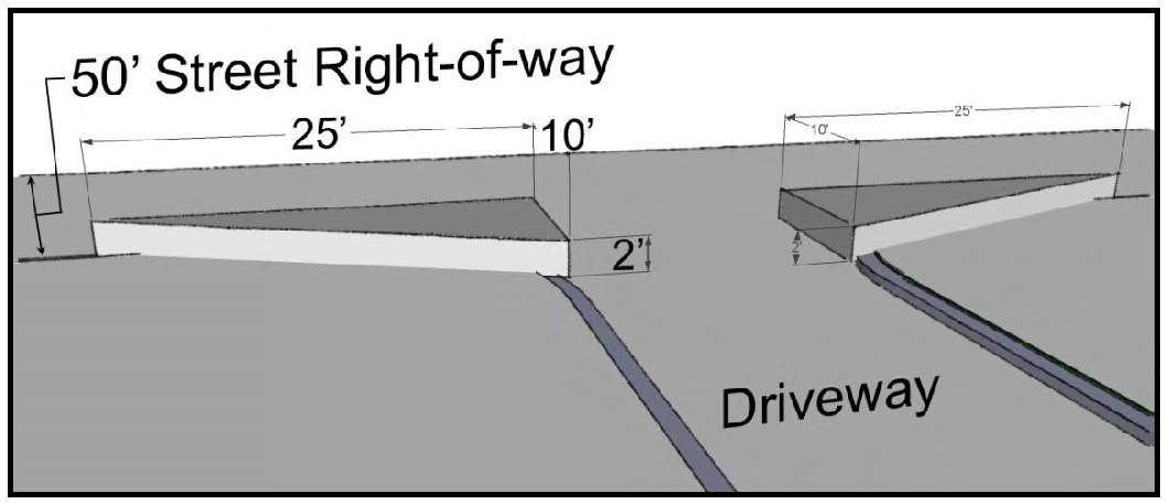
3.4.2 Dimensional Table.
N/A=Not applicable
DUA=Dwelling Units per Acre
1
Residential density applies to multi-family residential developments where allowed
in the Permitted Uses Table and may be used for Conservation Developments in lieu
of minimum lot areas in accordance with Section 4.2.3.
2
Minimum lot widths and setbacks in Conservation Developments may be reduced in accordance
Section 4.2.3.
3
TND developments in the R-6 district shall comply with Section 4.2.9
4
For residential uses, the requirements for the R-6 shall apply.
5
Because this district utilizes existing buildings, the lot width and setbacks are
subject to Board of Commissioners approval through the Conditional Zoning District
process. However, in no case shall a permit be issued for a development which encroaches
onto an adjacent piece of property. The minimum building size for the primary building
of the PRD district shall be 30,000 square feet.
3.4.3 Exceptions.
(A)
Setback distances shall be measured from the property line or street right-of-way line to the nearest portion of any building, or structure include:
(1)
Unenclosed porches, attached carports, balconies or decks which do not project into any required yard more than three (3) feet; and
(2)
Chimneys, flues, eaves, roof overhangs, window sills and bay windows which do not project into any required yard more than three (3) feet; and
(3)
Patios, drives, walkways, if no portion of the same extends more than 12 inches off the ground.
(B)
The height limitations of this Section shall apply to public buildings, churches, temples, schools, hospitals, belfries, cupolas and domes not intended for residential purposes, or to monuments, water towers, observation towers, power and communication transmission towers, flag poles and similar structures provided such structures meet the required North Carolina Building Code. Height limitations shall apply to cellular telephone towers as regulated herein.
(C)
The dimensional provisions of this section do not apply to residential accessory structures, which are regulated in Section 4.2.2.
(D)
Utility uses as defined by this Ordinance are not subject to the minimum lot sizes set forth for each zoning district.
(E)
Canopies, awnings, open stairways, uncovered porches, uncovered decks, uncovered patios, bay windows, chimneys and heating units may encroach into the setback up to three (3) feet.
(F)
Unattached, open carports less than twenty-four (24) feet by twenty-four (24) feet may be exempt from side and rear setback requirements, provided they do not extend more than five (5) feet beyond the front wall of the nearest point of any building.
(Ord. of 6-20-16(2); Ord. of 1- 7-19(3); Amend. of 12-16-19(1); Amend. of 1-16-20(1); Amend. of 10-3-22(3))
3.5 - Conditional Zoning Districts.
3.5.1 Purpose.
(A)
Conditional Zoning (CZ) districts are created to correspond to each of the zoning districts created in Section 3.2. CZ districts allow specific uses to be established in accordance with prescribed conditions pertaining to an individual project.
(B)
The purpose is to provide a voluntary alternative procedure for the rezoning of a property for a specific use. A broad range of uses are permitted in each zoning district. However, there are instances where a zoning district designation is clearly inappropriate for a property, but a specific use or uses permitted under this district and subject to development requirements would be consistent with the spirit and intent of this Ordinance. Conditional Zoning districts, herein established, are intended to accommodate such situations. This voluntary procedure is intended for firm development proposals, and is neither intended nor suited for securing early zoning for tentative uses which may not be undertaken for a long period of time.
(C)
Just as there are eleven (11) zoning districts, there are 10 corresponding Conditional Zoning Districts.
(1)
CZ R-20 Low Density Residential/Agricultural District.
(2)
CZ R-15 Low Density Residential District.
(3)
CZ R-8 Medium Density Residential District.
(4)
CZ R-6 High Density Residential District.
(5)
CZ OI Office and Institutional District.
(6)
CZ C-1 Central Business District.
(7)
CZ C-T Commercial Transition District.
(8)
CZ C-2 General Business District.
(9)
CZ C-3 Highway Business District.
(10)
CZ M-1 Industrial District.
(11)
CZ PRD Planned Adaptive Re-use District.
3.5.2 Applicability and Procedures.
(A)
Property may be placed in a Conditional Zoning district only in response to a petition by the owners of all the property to be included.
(B)
Specific conditions applicable to these districts may be proposed by the petitioner or the Town or its agencies, but only those conditions mutually approved by the Town and the petitioner may be incorporated into the requirements of the district. Conditions and site-specific standards imposed in a Conditional Zoning District shall be limited to those that address the conformance of the development and use of the site to the Town's ordinances and to any officially adopted comprehensive or other plan and those that address the impacts reasonably expected to be generated by the development or use of the site.
(C)
CZ Districts allows specific standards for a particular use after review and comment from the public. A petition to rezone a property to a Conditional Zoning District shall be accompanied by a site specific plan, in accordance with Section 14.6.
(D)
Within a CZ district, only those uses authorized as either permitted or conditional uses in the base zoning district with which the CZ district corresponds shall be permitted, and all other requirements of the corresponding district shall be met as minimum standards.
(E)
In approving a CZ district, the Board of Commissioners may impose such additional reasonable conditions upon such permit as it may deem necessary in order that the purpose and intent of this Ordinance are served, public welfare secured and substantial justice done.
(F)
CZ districts shall be approved in accordance with the process outlined in Chapter 14.
(Ord. of 6-20-16(2); Amend of 12-16-19(1); Ord. No. FCUDO-2021-03, att., 6-21-21)
3.6 - Overlay Districts.
The Zoning Districts and conditional zoning districts established in this Chapter may also be subject to one (1) or more overlay districts as designated herein and as shown on the Official Zoning Map. In such case, the land is subject to not only the requirements of the underlying Zoning Districts or conditional zoning district, but also the additional requirements of the overlay district.
3.6.1 Roadway Protection Overlay (RP-O) District.
The requirements of this section shall apply to all uses in the district except one and two family dwellings.
3.6.1.1 Landscaped Roadway Yard.
(A)
A landscaped roadway yard shall be provided by each use subject to this requirement. A landscaped roadway yard is a landscaped area generally parallel to the public roadway designed to provide continuity of vegetation along the right-of-way and pleasing view from the road. The landscaped area shall be penetrated only by driveways and crosswalks.
(B)
The minimum width of the roadway yard shall be 10 feet and shall be located within the 20 foot section of the lot closest to the public right-of-way.
(C)
It shall be landscaped and maintained with a vegetative cover and shall be planted with small and/or medium shrubs at a rate of 10 shrubs per 100 linear feet of street yard not counting driveway and crosswalk area.
(D)
The Administrator may approve a different vegetative landscape type when in his opinion equal or better performance will result.
3.6.1.2 Development with More Than One Principal Building.
In addition to the building design requirements of Section 5.4, developments in the district with more than one principal building (including "out parcels" and multi-tenant buildings) shall include similar architectural styles but should not be identical throughout the development. All sides of the individual building shall be treated in an architecturally similar manner. More specifically, at least two (2) of the following three (3) "unifying elements" must be presented in each building (including accessory buildings and those buildings located on out parcels) and to the greatest extent practical, in other architectural features of the development (walls, fences, signs, etc.):
(A)
Building Materials. Such material shall apply to at least 30 percent of each ground-mounted sign as well.
(B)
Colors. A maximum of three colors may be designated as the unifying element but the maximum number of colors throughout the development is not limited.
(C)
Architectural Features. These features include, but are not limited to: roof treatment (style, color, and material), façade treatments or building form (overhangs, canopies, arcades, protected walkways, and entrance treatments).
(Ord. of 6-20-16(2); Ord. No. FCUDO-2021-03, att., 6-21-21)