
Forest City City Zoning Code
CHAPTER 7
- ENVIRONMENTAL PROTECTION AND OPEN SPACE
7.1 - Purpose.
The purpose of this Chapter is:
(A)
To protect existing environmental resources including streams, wetlands, floodplains, soils, forest stands, specimen trees and other significant vegetation and wildlife.
(B)
To promote the reservation of open space in environmentally sensitive areas.
(C)
To provide of recreational amenities for the residents of the Town.
(Ord. of 6-20-16(2))
7.2 - Environmental Assessment and Suitability of Land.
7.2.1 Existing Features Plan.
Existing Features Plans are required for during the Sketch Plan step of all developments of greater than five (5) lots and with Zoning Permit applications for developments of greater than one (1) acre and shall be submitted in accordance with Section 12.2.
FIGURE 7.1: CONCEPTUAL EXISTING FEATURES PLAN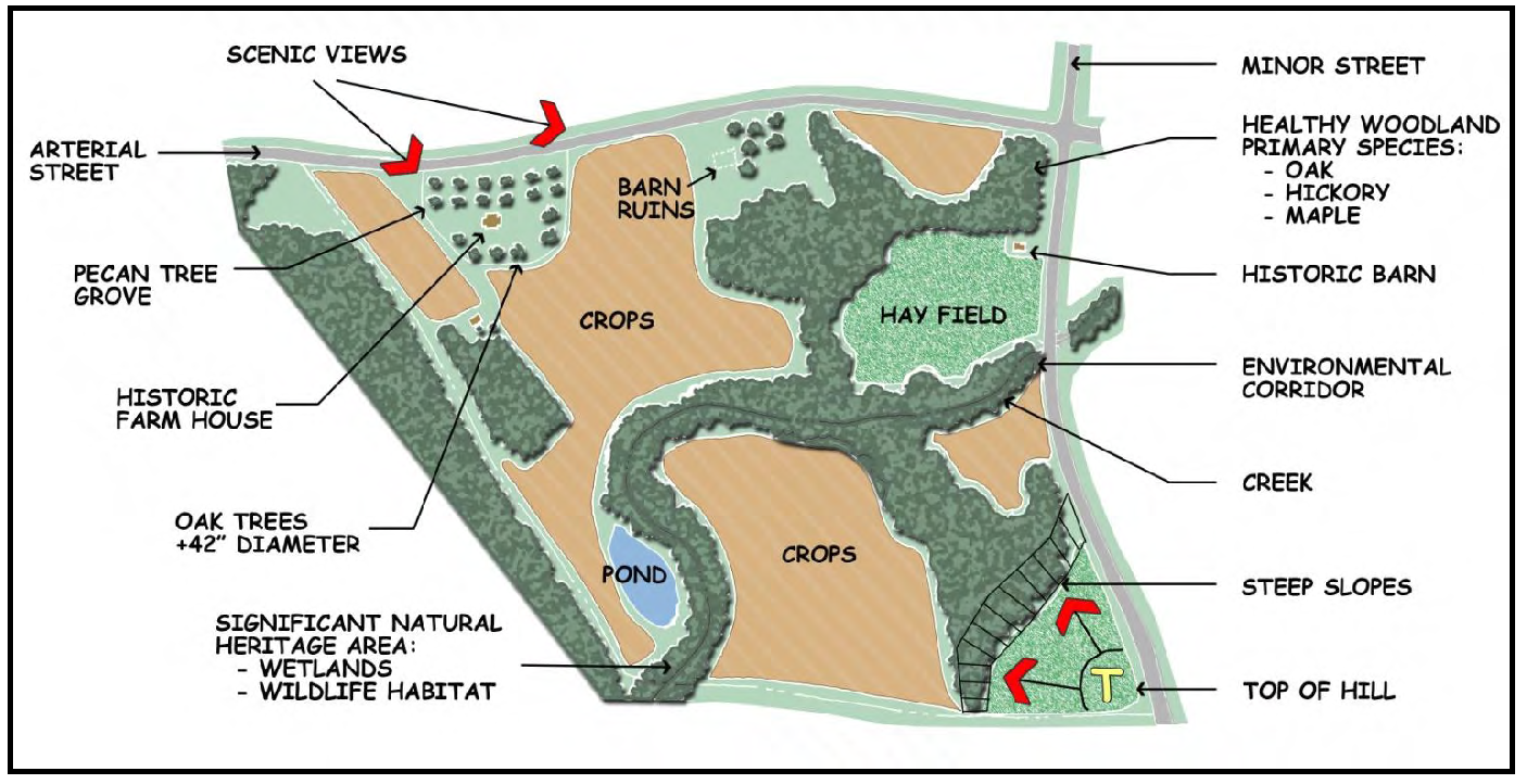
7.2.2 Preservation of Trees and Natural Features Encouraged.
(A)
Significant forest stands, natural vegetation, specimen trees, severe natural topography, drainage features and water courses are encouraged to be preserved to the extent that is reasonable and practical while otherwise not reasonably prohibiting development.
(B)
Forested and vegetated areas whose physical site conditions render them unsuitable for development should be set aside as conservation areas or as open space. Wooded sites should be developed with careful consideration of the natural characteristics of the site. When portions of forested stands must be developed, careful consideration should be given to preserving wooded perimeters or the most desirable natural features in order to retain the aesthetic or visual character of the site. Isolated pockets of existing trees or specimen trees should be protected as a valuable asset of the property.
(Ord. of 6-20-16(2))
7.3 - Stream Buffers.
7.3.1 Minimum Buffer.
Stream buffers shall be established on all perennial streams. The buffer shall be located a minimum of 20 feet from each side of the stream bed. Buffers shall remain undisturbed except that narrow walking paths may be utilized as part of the open space for a development.
FIGURE 7.2: STREAM BUFFER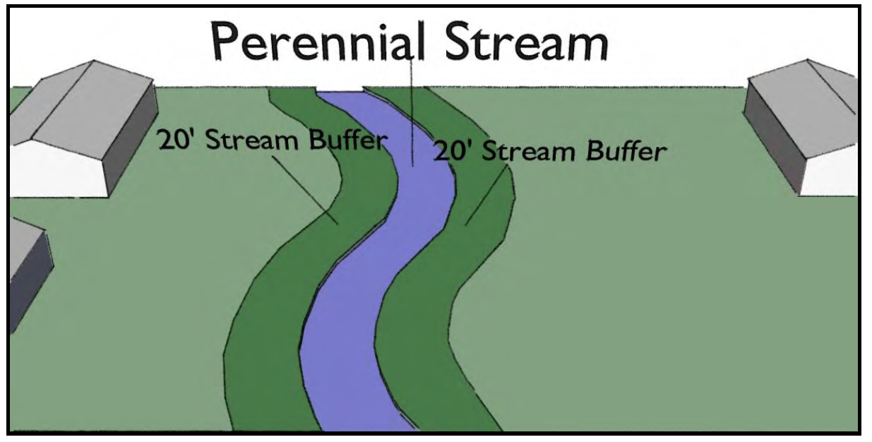
7.3.2 Acceptable Stream Plantings.
Below are lists of acceptable plants for stream restoration and preservation for the mountain region of North Carolina based on known commercial availability. This list is intended to be a basic guide. Not all plants are appropriate for all sites.
(A)
Trees.
(1)
Aesculus octandra - yellow buckeye
(2)
Betula lenta - cherry birch
(3)
Betula nigra - river birch
(4)
Carya cordiformis - bitternut hickory
(5)
Carya ovata - shagbark hickory
(6)
Diospyros virginiana - persimmon
(7)
Fraxinus pennsylvanica - green ash
(8)
Halesia caroliniana - silverbell
(9)
Nyssa sylvatica - blackgum
(10)
Platanus occidentalis - sycamore
(11)
Salix nigra - black widow
(12)
Tilia heterophylla - white basswood
(B)
Small Trees and Shrubs.
(1)
Alnus serrulata - tag alder
(2)
Amelanchier arborea - serviceberry
(3)
Aronia arbutifolia - red chokeberry
(4)
Asimina triloba - common pawpaw
(5)
Calycanthus floridus - sweet-shrub
(6)
Carpinus caroliniana - ironwood
(7)
Cornus alternifolia - alternate leaf dogwood
(8)
Cornus amomum - silky dogwood
(9)
Corylus Americana - hazel-nut
(10)
Hamamelis virginiana - witch hazel
(11)
Ilex verticillata - winter berry
(12)
Leucothoe axillaris - doghobble
(13)
Lindera benzoin - spicebush
(14)
Lyonia ligustrina - male-berry
(15)
Magnolia tripetala - umbrella tree
(16)
Physocarpus opulifolius - ninebark
(17)
Rhodendron periclymenoides - wild azalea
(18)
Rhodendron viscosum - swamp azalea
(19)
Rosa palustris - swamp rose
(20)
Salix sericea - silky willow
(21)
Spirea latifolia - meadowsweet
(22)
Symplocos tinctoria - sweet leaf
(23)
Vibunum cassinoides - withe-rod
(24)
Xanthorhiza simplicissima - yellow-root
(C)
Herbaceous Plants.
(1)
Arisaema triphyllum - jack-in-the-pulpit
(2)
Asclepias incarnata - swamp milkweed
(3)
Carex crinata - fringed sedge
(4)
Carex intumescens - bladder sedge
(5)
Carex lupulina - hop sedge
(6)
Carex lurida - lurid sedge
(7)
Carex scoparia - broom sedge
(8)
Carex stricta - tussock sedge
(9)
Carex vulpinoidea - fox sedge
(10)
Chelone glabra - turtlehead
(11)
Cyperus strigosus - umbrella sedge
(12)
Elymus hystrix - bottlebrush grass
(13)
Eupatorium fistulosum - joe-pye-weed
(14)
Eupatorium perfoliatum - boneset
(15)
Impatiens capensis - jewel-weed
(16)
Juncus effuses - soft rush
(17)
Leersia oryzoides - rice cutgrass
(18)
Lobelia cardinalis - cardinal flower
(19)
Lobelia siphilitica - great blue lobelia
(20)
Ludwigia - alternifolia - bushy seedbox
(21)
Panicum virgatum - switchgrass
(22)
Polygonum sagittatum - tearthumb
(23)
Scirpus altrovirens - green bulrush
(24)
Scirpus cyperinus - woolgrass
(25)
Scirpus validus - soft stem bulrush
(26)
Sparganium americanum - bur-reed
(27)
Thelypteris palustris - marsh fern
(28)
Uniola latifolia - river oats
(29)
Vernonia noveboracensis - ironweed
(D)
Prohibited Invasive Plants.
(1)
Ailanthus altissima - Tree-of-heaven
(2)
Celastrus orbiculatus - Oriental Bittersweet
(3)
Elaeagnus umbellata - Silverberry
(4)
Hedera helix - English Ivy
(5)
Ligustrum sinense - Chinese Privet
(6)
Lonicera japonica - Japanese Honeysuckle
(7)
Microstegium vimineum - Microstegium
(8)
Polygonum cuspidatum - Japanese Knotweed
(9)
Pueraria lobata - Kudzu
(10)
Rosa multiflora - Multiflora Rose
Source: Hall, Karen. Recommended Native Plant Species for Stream Restoration in North Carolina. Raleigh, NC: North Carolina State University, NC Stream Restoration Institute, May 2003.
(Ord. of 6-20-16(2))
7.4 - Flood Damage Prevention.
The following regulations were adopted May 5, 2008 in accordance with the state model ordinance: 7.4.1
7.4.1 Statutory Authorization, Findings of Fact, Purpose and Objectives.
(A)
Statutory Authorization. The Legislature of the State of North Carolina has in Part 6, Article 21 of Chapter 143 and 160D-923 of the North Carolina General Statutes, delegated to local governmental units the responsibility to adopt regulations designed to promote the public health, safety and general welfare.
Therefore, the Board of Commissioners of the Town of Forest City, North Carolina, does ordain as follows:
7.4.2 Findings of Fact.
(A)
The flood prone areas within the jurisdiction of the Town of Forest City are subject to periodic inundation which results in loss of life, property, health and safety hazards, disruption of commerce and governmental services, extraordinary public expenditures of flood protection and relief and impairment of the tax base, all of which adversely affect the public health, safety and general welfare.
(B)
These flood losses are caused by the cumulative effect of obstructions in floodplains causing increases in flood heights and velocities and by the occupancy in flood prone areas of uses vulnerable to floods or other hazards.
7.4.3 Statement of Purpose.
It is the purpose of this Section to promote public health, safety and general welfare and to minimize public and private losses due to flood conditions within flood prone areas by provisions designed to:
(A)
Restrict or prohibit uses that are dangerous to health, safety and property due to water or erosion hazards or that result in damaging increases in erosion, flood heights or velocities;
(B)
Require that uses vulnerable to floods, including facilities that serve such uses, be protected against flood damage at the time of initial construction;
(C)
Control the alteration of natural floodplains, stream channels and natural protective barriers, which are involved in the accommodation of floodwaters;
(D)
Control filling, grading, dredging and all other development that may increase erosion or flood damage; and
(E)
Prevent or regulate the construction of flood barriers that will unnaturally divert flood waters or which may increase flood hazards to other lands.
7.4.4 Objectives.
The objectives of this Section are to:
(A)
Protect human life, safety and health;
(B)
Minimize expenditure of public money for costly flood control projects;
(C)
Minimize the need for rescue and relief efforts associated with flooding and generally undertaken at the expense of the general public;
(D)
Minimize prolonged business losses and interruptions;
(E)
Minimize damage to public facilities and utilities (i.e. Water and gas mains, electric, telephone, cable and sewer lines, streets and bridges) that are located in flood prone areas;
(F)
Help maintain a stable tax base by providing for the sound use and development of flood prone areas; and
(G)
Ensure that potential buyers are aware that property is in a special flood hazard area.
7.4.5 Definitions.
See Appendix A for Flood Damage Prevention Definitions. Unless specifically defined in Appendix A, words or phrases used in this subsection shall be interpreted so as to give them the meaning they have in common usage and to give this Section its most reasonable application.
7.4.6 General Provisions.
(A)
Applicability. This Section shall apply to all Special Flood Hazard Areas within the jurisdiction of the Town of Forest City and within the jurisdiction of any other community whose governing body agrees, by resolution, to such applicability.
(B)
Basis for Establish the Special Flood Hazard Areas. The Special Flood Hazard Areas are those identified under the Cooperating Technical State (CTS) agreement between the State of North Carolina and FEMA in its Flood Insurance Study (FIS) for Rutherford County dated July 2, 2008 and its accompanying Flood Insurance Rate Map (FIRM), which are adopted by reference and declared to be a part of this Section. The initial Flood Insurance Rate Maps are as follows for the jurisdictional areas at the initial date:
(1)
Rutherford County Unincorporated Area, dated June 1, 1987.
(2)
Town of Forest City, dated June 17, 1986.
(C)
Establishment of Floodplain Development Permit. A Floodplain Development Permit shall be required in conformance with the provisions of this Section prior to the commencement of any development activities within Special Flood Hazard Areas determined in accordance with the provisions of Section 7.4.3, Subsection B.
(D)
Compliance. No structure or land shall hereafter be located, extended, converted, altered, or developed in any way without full compliance with the terms of this Section and other applicable regulations.
(E)
Abrogation and Greater Restrictions. This Section is not intended to repeal, abrogate, or impair any existing easements, covenants, or deed restrictions. However, where this Section and another conflict or overlap, whichever imposes the more stringent restrictions shall prevail.
(F)
Interpretation. In the interpretation and application of this Section, all provisions shall be:
(1)
Considered as minimum requirements;
(2)
Liberally construed in favor of the governing body; and
(3)
Deemed neither to limit nor repeal any other powers granted under state statutes.
(G)
Warning and Disclaimer of Liability. The degree of flood protection required by this Section is considered reasonable for regulatory purposes and is based on scientific and engineering consideration. Larger floods can and will occur. Actual flood heights may be increased by man-made or natural causes. This Section does not imply that land outside the Special Flood Hazard Areas or uses permitted within such areas will be free from flooding or flood damages. This Section shall not create liability on the part of the Town of Forest City or by any officer or employee thereof for any flood damages that result from reliance on this Section or any administrative decision lawfully made hereunder.
(H)
Penalties for Violation. Violation of the provisions of this Section or failure to comply with any of its requirements, including violation of conditions and safeguards established in connection with grants of variance or special exceptions, shall constitute a misdemeanor. Any person who violates this Section or fails to comply with any of its requirements shall, upon conviction thereof, be fined not more than $50.00 or imprisoned for not more than 30 days, or both. Each day such violation continues shall be considered a separate offense. Nothing herein contained shall prevent the Town of Forest City from taking such other lawful action as is necessary to prevent or remedy any violation.
7.4.7 Administration.
(A)
Designation of Floodplain Administrator. The Town Clerk or his/her designee, hereinafter referred to as the "Floodplain Administrator", is hereby appointed to administer and implement the provisions of this Section.
(B)
Floodplain Development Application, Permit and Certification Requirements.
(1)
Application Requirements. Application for a Floodplain Development Permit shall be made to the Floodplain Administrator prior to any development activities located within Special Flood Hazard Areas. The following items shall be presented to the Floodplain Administrator to apply for a floodplain development permit:
(a)
A plot plan drawn to scale which shall include, but shall not be limited to, the following specific details of the proposed floodplain development:
i.
The nature, location, dimensions and elevations of the area of development/disturbance; existing and proposed structures, utility systems, grading/pavement areas, fill materials, storage areas, drainage facilities and other development;
ii.
The boundary of the special flood hazard area as delineated on the firm or other flood map as determined in section 7.4.3, subsection b, or a statement that the entire lot is within the special flood hazard area;
iii.
Flood zone(s) designation of the proposed development area as determined on the firm or other flood map as determined in section 7.4.3, subsection b;
iv.
The boundary of the floodway(s) or non-encroachment area(s) as determined in section 7.4.3, subsection b;
v.
The base flood elevation (bfe) where provided as set forth in section 7.4.3, subsection b; section 7.4.4, subsection c; or section 7.4.5, subsection d;
vi.
The old and new location of any watercourse that will be altered or relocated as a result of proposed development; and
vii.
The certification of the plot plan by a professional land surveyor or professional engineer.
(b)
Proposed elevation, and method thereof, of all development within a Special Flood Hazard Area including but not limited to:
i.
Elevation in relation to mean sea level of the proposed reference level (including basement) of all structures;
ii.
Elevation in relation to mean sea level to which any non-residential structure in Zone AE, A or AO will be floodproofed; and
iii.
Elevation in relation to mean sea level to which any proposed utility systems will be elevated or floodproofed.
(c)
If floodproofing, a Floodproofing Certificate (FEMA Form 81-65) with supporting data, an operational plan and an inspection and maintenance plan that include, but are not limited to, installation, exercise and maintenance of floodproofing measures.
(d)
A Foundation Plan, drawn to scale,, which shall include details of the proposed foundation system to ensure all provisions of this Section are met. These details include but are not limited to:
i.
The proposed method of elevation, if applicable (i.e., fill, solid foundation perimeter wall, solid backfilled foundation, open foundation on columns/posts/piers/piles/shear walls); and
ii.
Openings to facilitate automatic equalization of hydrostatic flood forces on walls in accordance with Section 7.4.5, Subsection B(4)(c) when solid foundation perimeter walls are used in Zones A, AO, AE and A1-30.
(e)
Usage details of any enclosed areas below the lowest floor.
(f)
Plans and/or details for the protection of public utilities and facilities such as sewer, gas, electrical and water systems to be located and constructed to minimize flood damage.
(g)
Certification that all other Local, State and Federal permits required prior to floodplain development permit issuance have been received.
(h)
Documentation for placement of Recreational Vehicles and/or Temporary Structures, when applicable, to ensure that the provisions of Section 7.4.5, Subsection B, (6) and (7) are met.
(i)
A description of proposed watercourse alteration or relocation, when applicable, including an engineering report on the effects of the proposed project on the flood-carrying capacity of the watercourse and the effects to properties located both upstream and downstream; and a map (if not shown on plot plan) showing the location of the proposed watercourse alteration or relocation.
(2)
Permit Requirements. The Floodplain Development Permit shall include, but not be limited to:
(a)
A description of the development to be permitted under the floodplain development permit.
(b)
The Special Flood Hazard Area determination for the proposed development in accordance with available data specified in Section 7.4.3, Subsection B.
(c)
The Regulatory Flood Protection Elevation required for the reference level and all attendant utilities.
(d)
The Regulatory Flood Protection Elevation required for the protection of all public utilities.
(e)
All certification submittal requirements with timelines.
(f)
A statement that no fill material or other development shall encroach into the floodway or non-encroachment area of any watercourse, as applicable.
(g)
The flood openings requirements, if in Zones A, AO, AE or A1-30.
(h)
Limitations of below BFE enclosure uses (if applicable). (i.e., parking, building access and limited storage only).
(3)
Certification Requirements.
(a)
Elevation Certificates.
i.
An Elevation Certificate (FEMA Form 81-31) is required prior to the actual start of any new construction. It shall be the duty of the permit holder to submit to the Floodplain Administrator a certification of the elevation of the reference level, in relation to mean sea level. The Floodplain Administrator shall review the certificate data submitted. Deficiencies detected by such review shall be corrected by the permit holder prior to the beginning of construction. Failure to submit the certification or failure to make required corrections shall be cause to deny a floodplain development permit.
ii.
A final as-built Elevation Certificate (FEMA Form 81-31) is required after construction is completed and prior to Certificate of Compliance/Occupancy issuance. It shall be the duty of the permit holder to submit to the Floodplain Administrator a certification of final as-built construction of the elevation of the reference level and all attendant utilities. The Floodplain Administrator shall review the certificate data submitted. Deficiencies detected by such review shall be corrected by the permit holder immediately and prior to Certificate of Compliance/Occupancy issuance. In some instances, another certification may be required to certify corrected as-built construction. Failure to submit the certification or failure to make required corrections shall be cause to withhold the issuance of a Certificate of Compliance/Occupancy.
(b)
Floodproofing Certificate.
i.
If non-residential floodproofing is used to meet the Regulatory Flood Protection Elevation requirements, a Floodproofing Certificate (FEMA Form 81-65), with supporting data, an operational plan and an inspection and maintenance plan are required prior to the actual start of any new construction. It shall be the duty of the permit holder to submit to the Floodplain Administrator a certification of the floodproofed design elevation of the reference level and all attendant utilities, in relation to mean sea level. Floodproofing certification shall be prepared by or under the direct supervision of a professional engineer or architect and certified by same. The Floodplain Administrator shall review the certificate data, the operational plan and the inspection and maintenance plan. Deficiencies detected by such review shall be corrected by the applicant prior to permit approval. Failure to submit the certification or failure to make required corrections shall be cause to deny a Floodplain Development Permit. Failure to construct in accordance with the certified design shall be cause to withhold the issuance of a Certificate of Compliance/Occupancy.
(c)
If a manufactured home is placed within Zone A, AO, AE, or A1-30 and the elevation of the chassis is more than 36 inches in height above grade, an engineered foundation certification is required in accordance with the provisions of Section 7.4.5, Subsection B(3)(b).
(d)
If a watercourse is to be altered or relocated, a description of the extent of watercourse alteration or relocation; a professional engineer's certified report on the effects of the proposed project on the flood-carrying capacity of the watercourse and the effects to properties located both upstream and downstream; and a map showing the location of the proposed watercourse alteration or relocation shall all be submitted by the permit applicant prior to issuance of a floodplain development permit.
(e)
Certification Exemptions. The following structures, if located within Zone A, AO, AE or A1-30, are exempt from the elevation/floodproofing certification requirements specified in items (a) and (b) of this subsection:
i.
Recreational Vehicles meeting requirements of Section 7.4.5, Subsection B(6)(a);
ii.
Temporary Structures meeting requirements of Section 7.4.5, Subsection B(7); and
iii.
Accessory Structures less than 150 square feet meeting requirements of Section 7.4.5, Subsection B(8).
(C)
Duties and Responsibilities of the Floodplain Administrator. The Floodplain Administrator shall perform, but not be limited to, the following duties:
(1)
Review all floodplain development applications and issue permits for all proposed development within Special Flood Hazard Areas to assure that the requirements of this Section have been satisfied.
(2)
Review all proposed development within Special Flood Hazard Areas to assure that all necessary Local, State and Federal permits have been received.
(3)
Notify adjacent communities and the North Carolina Department of Crime Control and Public Safety, Division of Emergency Management, State Coordinator for the National Flood Insurance Program prior to any alteration or relocation of a watercourse, and submit evidence of such notification to the Federal Emergency Management Agency (FEMA).
(4)
Assure that maintenance is provided within the altered or relocated portion of said watercourse so that the flood-carrying capacity is maintained.
(5)
Prevent encroachments into floodways and non-encroachment areas unless the certification and flood hazard reduction provisions of Section 7.4.5, Subsection F are met.
(6)
Obtain actual elevation (in relation to mean sea level) of the reference level (including basement) and all attendant utilities of all new and substantially improved structures, in accordance with the provisions of Section 7.4.4, Subsection B(3).
(7)
Obtain actual elevation (in relation to mean sea level) to which all new and substantially improved structures and utilities have been floodproofed, in accordance with the provisions of Section 7.4.4, Subsection B(3).
(8)
Obtain actual elevation (in relation to mean sea level) of all public utilities in accordance with the provisions of Section 7.4.4, Subsection B(3).
(9)
When floodproofing is utilized for a particular structure, obtain certifications from a registered professional engineer or architect in accordance with the provisions of Section 7.4.4, Subsection B(3) and Section 7.4.5, Subsection B(2).
(10)
Where interpretation is needed as to the exact location of boundaries of the Special Flood Hazard Areas, floodways, or non-encroachment areas (for example, where there appears to be a conflict between a mapped boundary and actual field conditions), make the necessary interpretation. The person contesting the location of the boundary shall be given a reasonable opportunity to appeal the interpretation as provided in this Section.
(11)
When Base Flood Elevation (BFE) data has not been provided in accordance with the provisions of Section 7.4.3, Subsection B, obtain, review and reasonably utilize any BFE data, along with floodway data or non-encroachment area data available from a Federal, State, or other source, including data developed pursuant to Section 7.4.5, Subsection D(2)(b), in order to administer the provisions of this Section.
(12)
When Base Flood Elevation (BFE) data is provided but no floodway or non-encroachment area data has been provided in accordance with the provisions of Section 7.4.3, Subsection B, obtain, review and reasonably utilize any floodway data or non-encroachment area data available from a Federal, State, or other source in order to administer the provisions of this Section.
(13)
When the lowest floor and the lowest adjacent grade of a structure or the lowest ground elevation of a parcel in a Special Flood Hazard Area is above the Base Flood Elevation (BFE), advise the property owner of the option to apply for a Letter of Map Amendment (LOMA) from FEMA. Maintain a copy of the LOMA issued by FEMA in the floodplain development permit file.
(14)
Permanently maintain all records that pertain to the administration of this Section and make these records available for public inspection, recognizing that such information may be subject to the Privacy Act of 1974, as amended.
(15)
Make on-site inspections of work in progress. As the work pursuant to a floodplain development permit progresses, the Floodplain Administrator shall make as many inspections of the work as may be necessary to ensure that the work is being done according to the provisions of the local Section and the terms of the permit. In exercising this power, the Floodplain Administrator has a right, upon presentation of proper credentials, to enter on any premises within the jurisdiction of the community at any reasonable hour for the purposes of inspection or other enforcement action.
(16)
Issue stop-work orders as required. Whenever a building or part thereof is being constructed, reconstructed, altered, or repaired in violation of this Section, the Floodplain Administrator may order the work to be immediately stopped. The stop-work order shall be in writing and directed to the person doing or in charge of the work. The stop-work order shall state the specific work to be stopped, the specific reason(s) for the stoppage, and the condition(s) under which the work may be resumed. Violation of a stop-work order constitutes a misdemeanor.
(17)
Revoke floodplain development permits as required. The Floodplain Administrator may revoke and require the return of the floodplain development permit by notifying the permit holder in writing stating the reason(s) for the revocation. Permits shall be revoked for any substantial departure from the approved application, plans and specifications; for refusal or failure to comply with the requirements of State or local laws; or for false statements or misrepresentations made in securing the permit. Any floodplain development permit mistakenly issued in violation of an applicable State or local law may also be revoked.
(18)
Make periodic inspections throughout the Special Flood Hazard Areas within the jurisdiction of the community. The Floodplain Administrator and each member of his or her inspections department shall have a right, upon presentation of proper credentials, to enter on any premises within the territorial jurisdiction of the department at any reasonable hour for the purposes of inspection or other enforcement action.
(19)
Follow through with corrective procedures of Section 7.4.4, Subsection D.
(20)
Review, provide input and make recommendations for variance requests.
(21)
Maintain a current map repository to include, but not limited to, the FIS Report, FIRM and other official flood maps and studies adopted in accordance with the provisions of Section 7.4.3, Subsection B, including any revisions thereto including Letters of Map Change, issued by FEMA. Notify State and FEMA of mapping needs.
(22)
Coordinate revisions to FIS reports and FIRMs, including Letters of Map Revision Based on Fill (LOMR-Fs) and Letters of Map Revision (LOMRs).
(D)
Corrective Procedures.
(1)
Violations to be Corrected. When the Floodplain Administrator finds violations of applicable State and local laws, it shall be his or her duty to notify the owner or occupant of the building of the violation. The owner or occupant shall immediately remedy each of the violations of law cited in such notification.
(2)
Actions in Event of Failure to Take Corrective Action. If the owner of a building or property shall fail to take prompt corrective action, the Floodplain Administrator shall give the owner written notice, by certified or registered mail to the owner's last known address or by personal service, stating:
(a)
That the building or property is in violation of the floodplain management regulations;
(b)
That a hearing will be held before the floodplain administrator at a designated place and time, not later than 10 days after the date of the notice, at which time the owner shall be entitled to be heard in person or by counsel and to present arguments and evidence pertaining to the matter; and
(c)
That following the hearing, the floodplain administrator may issue an order to alter, vacate, or demolish the building; or to remove fill as applicable
(3)
Order to Take Corrective Action. If, upon a hearing held pursuant to the notice prescribed above, the Floodplain Administrator shall find that the building or development is in violation of the Flood Damage Prevention regulations, he or she shall issue an order in writing to the owner, requiring the owner to remedy the violation within 90 days of issuance. Where the Floodplain Administrator finds that there is imminent danger to life or other property, he or she may order that corrective action be taken in such lesser period as may be feasible.
(4)
Appeal. Any owner who has received an order to take corrective action may appeal the order to the local elected governing body by giving notice of appeal in writing to the Floodplain Administrator and the clerk within 10 days following issuance of the final order. In the absence of an appeal, the order of the Floodplain Administrator shall be final. The local governing body shall hear an appeal within a reasonable time and may affirm, modify and affirm, or revoke the order.
(5)
Failure to Comply with Order. If the owner of a building or property fails to comply with an order to take corrective action for which no appeal has been made or fails to comply with an order of the governing body following an appeal, the owner shall be guilty of a misdemeanor and shall be punished at the discretion of the court.
(E)
Variance Procedures.
(1)
The Board of Adjustment as established by the Town of Forest City, hereinafter referred to as the "appeal board", shall hear and decide requests for variances from the requirements of this Section.
(2)
Any person aggrieved by the decision of the appeal board may appeal such decision to the Court, as provided in Chapter 7A of the North Carolina General Statutes.
(3)
Variances may be issued for:
(a)
The repair or rehabilitation of historic structures upon the determination that the proposed repair or rehabilitation will not preclude the structure's continued designation as a historic structure and that the variance is the minimum necessary to preserve the historic character and design of the structure;
(b)
Functionally dependent facilities if determined to meet the definition as stated in Appendix A, provided provisions of section 7.4.4, subsection e(9)(b), (c) and (e) have been satisfied, and such facilities are protected by methods that minimize flood damages during the base flood and create no additional threats to public safety; or
(c)
Any other type of development, provided it meets the requirements of this subsection.
(4)
In passing upon variances, the appeal board shall consider all technical evaluations, all relevant factors, all standards specified in other subsections, and:
(a)
The danger that materials may be swept onto other lands to the injury of others;
(b)
The danger to life and property due to flooding or erosion damage;
(c)
The susceptibility of the proposed facility and its contents to flood damage and the effect of such damage on the individual owner;
(d)
The importance of the services provided by the proposed facility to the community;
(e)
The necessity to the facility of a waterfront location as defined under Appendix A as a functionally dependent facility, where applicable;
(f)
The availability of alternative locations, not subject to flooding or erosion damage, for the proposed use;
(g)
The compatibility of the proposed use with existing and anticipated development;
(h)
The relationship of the proposed use to the comprehensive plan and floodplain management program for that area;
(i)
The safety of access to the property in times of flood for ordinary and emergency vehicles;
(j)
The expected heights, velocity, duration, rate of rise and sediment transport of the floodwaters and the effects of wave action, if applicable, expected at the site; and
(k)
The costs of providing governmental services during and after flood conditions including maintenance and repair of public utilities and facilities such as sewer, gas, electrical and water systems, and streets and bridges.
(5)
A written report addressing each of the above factors shall be submitted with the application for a variance.
(6)
Upon consideration of the factors listed above and the purposes of this Section, the appeal board may attach such conditions to the granting of variances as it deems necessary to further the purposes and objectives of this Section.
(7)
Any applicant to whom a variance is granted shall be given written notice specifying the difference between the Base Flood Elevation (BFE) and the elevation to which the structure is to be built and that such construction below the BFE increases risks to life and property, and that the issuance of a variance to construct a structure below the BFE will result in increased premium rates for flood insurance up to $25 per $100 of insurance coverage. Such notification shall be maintained with a record of all variance actions, including justification for their issuance.
(8)
The Floodplain Administrator shall maintain the records of all appeal actions and report any variances to the Federal Emergency Management Agency and the State of North Carolina upon request.
(9)
Conditions for Variances:
(a)
Variances shall not be issued when the variance will make the structure in violation of other Federal, State, or local laws, regulations, or ordinances.
(b)
Variances shall not be issued within any designated floodway or non-encroachment area if the variance would result in any increase in flood levels during the base flood discharge.
(c)
Variances shall only be issued upon a determination that the variance is the minimum necessary, considering the flood hazard, to afford relief.
(d)
Variances shall only be issued prior to development permit approval.
(e)
Variances shall only be issued upon:
i.
A showing of good and sufficient cause;
ii.
A determination that failure to grant the variance would result in exceptional hardship; and
iii.
A determination that the granting of a variance will not result in increased flood heights, additional threats to public safety, or extraordinary public expense, create nuisance, cause fraud on or victimization of the public, or conflict with existing local laws or ordinances.
7.4.8 Provisions for Flood Hazard Reduction.
(A)
General Standards. In all Special Flood Hazard Areas the following provisions are required:
(1)
All new construction and substantial improvements shall be designed (or modified) and adequately anchored to prevent flotation, collapse and lateral movement of the structure.
(2)
All new construction and substantial improvements shall be constructed with materials and utility equipment resistant to flood damage.
(3)
All new construction and substantial improvements shall be constructed by methods and practices that minimize flood damages.
(4)
Electrical, heating, ventilation, plumbing, air conditioning equipment and other service facilities shall be designed and/or located so as to prevent water from entering or accumulating within the components during conditions of flooding to the Regulatory Flood Protection Elevation. These include, but are not limited to, HVAC equipment, water softener units, bath/kitchen fixtures, ductwork, electric/gas meter panels/boxes, utility/cable boxes, hot water heaters and electric outlets/switches.
(5)
All new and replacement water supply systems shall be designed to minimize or eliminate infiltration of floodwaters into the system.
(6)
New and replacement sanitary sewage systems shall be designed to minimize or eliminate infiltration of floodwaters into the systems and discharges from the systems into flood waters.
(7)
On-site waste disposal systems shall be located and constructed to avoid impairment to them or contamination from them during flooding.
(8)
Any alteration, repair, reconstruction, or improvements to a structure, which is in compliance with the provisions of this Section, shall meet the requirements of "new construction" as contained in this Section.
(9)
Nothing in this Section shall prevent the repair, reconstruction, or replacement of a building or structure existing on the effective date of this Section and located totally or partially within the floodway, non-encroachment area, or stream setback, provided there is no additional encroachment below the Regulatory Flood Protection Elevation in the floodway, non-encroachment area, or stream setback, and provided that such repair, reconstruction, or replacement meets all of the other requirements of this Section.
(10)
New solid waste disposal facilities and sites, hazardous waste management facilities, salvage yards and chemical storage facilities shall not be permitted. A structure or tank for chemical or fuel storage incidental to an allowed use or to the operation of a water treatment plant or wastewater treatment facility may be located in a Special Flood Hazard Area only if the structure or tank is either elevated or floodproofed to at least the Regulatory Flood Protection Elevation and certified in accordance with the provisions of Section 7.4.4, Subsection B(3).
(11)
All subdivision proposals and other development proposals shall be consistent with the need to minimize flood damage.
(12)
All subdivision proposals and other development proposals shall have public utilities and facilities such as sewer, gas, electrical and water systems located and constructed to minimize flood damage.
(13)
All subdivision proposals and other development proposals shall have adequate drainage provided to reduce exposure to flood hazards.
(14)
All subdivision proposals and other development proposals shall have received all necessary permits from those governmental agencies for which approval is required by Federal or State law, including Section 404 of the Federal Water Pollution Control Act Amendments of 1972, 33 U.S.C. 1334.
(15)
When a structure is partially located in a Special Flood Hazard Area, the entire structure shall meet the requirements for new construction and substantial improvements.
(16)
When a structure is located in multiple flood hazard zones or in a flood hazard risk zone with multiple base flood elevations, the provisions for the more restrictive flood hazard risk zone and the highest Base Flood Elevation (BFE) shall apply.
(B)
Specific Standards. In all Special Flood Hazard Areas where Base Flood Elevation (BFE) data has been provided, as set forth in Section 7.4.3, Subsection B, or Section 7.4.5, Subsection D, the following provisions, in addition to the provisions of Section 7.4.5, Subsection A, are required:
(1)
Residential Construction. New construction and substantial improvement of any residential structure (including manufactured homes) shall have the reference level, including basement, elevated no lower than the Regulatory Flood Protection Elevation, as defined in Appendix A.
(2)
Non-Residential Construction. New construction and substantial improvement of any commercial, industrial, or other non-residential structure shall have the reference level, including basement, elevated no lower than the Regulatory Flood Protection Elevation, as defined in Appendix A. Structures located in A, AE, AO and A1-30 Zones may be floodproofed to the Regulatory Flood Protection Elevation in lieu of elevation provided that all areas of the structure, together with attendant utility and sanitary facilities, below the Regulatory Flood Protection Elevation are watertight with walls substantially impermeable to the passage of water, using structural components having the capability of resisting hydrostatic and hydrodynamic loads and the effect of buoyancy. For AO Zones, the floodproofing elevation shall be in accordance with Section 7.4.5, Subsection G(2). A registered professional engineer or architect shall certify that the floodproofing standards of this subsection are satisfied. Such certification shall be provided to the Floodplain Administrator as set forth in Section 7.4.4, Subsection B(3), along with the operational plan and the inspection and maintenance plan.
(3)
Manufactured Homes.
(a)
New and replacement manufactured homes shall be elevated so that the reference level of the manufactured home is no lower than the Regulatory Flood Protection Elevation, as defined in Appendix A.
(b)
Manufactured homes shall be securely anchored to an adequately anchored foundation to resist flotation, collapse and lateral movement, either by certified engineered foundation system, or in accordance with the most current edition of the State of North Carolina Regulations for Manufactured Homes adopted by the Commissioner of Insurance pursuant to NCGS 143-143.15. Additionally, when the elevation would be met by an elevation of the chassis 36 inches or less above the grade at the site, the chassis shall be supported by reinforced piers or engineered foundation. When the elevation of the chassis is above 36 inches in height, an engineering certification is required.
(c)
All enclosures or skirting below the lowest floor shall meet the requirements of Section 7.4.5, Subsection B(4).
(d)
An evacuation plan must be developed for evacuation of all residents of all new, substantially improved or substantially damaged manufactured home parks or subdivisions located within flood prone areas. This plan shall be filed with and approved by the Floodplain Administrator and the local Emergency Management Coordinator.
(4)
Elevated Buildings. Fully enclosed area, of new construction and substantially improved structures, which is below the lowest floor:
(a)
shall not be designed or used for human habitation, but shall only be used for parking of vehicles, building access, or limited storage of maintenance equipment used in connection with the premises. Access to the enclosed area shall be the minimum necessary to allow for parking of vehicles (garage door) or limited storage of maintenance equipment (standard exterior door), or entry to the living area (stairway or elevator). The interior portion of such enclosed area shall not be finished or partitioned into separate rooms, except to enclose storage areas;
(b)
shall be constructed entirely of flood resistant materials.
(c)
shall include, in Zones A, AO, AE and A1-30, flood openings to automatically equalize hydrostatic flood forces on walls by allowing for the entry and exit of floodwaters. To meet this requirement, the openings must either be certified by a professional engineer or architect or meet or exceed the following minimum design criteria:
i.
A minimum of two (2) flood openings on different sides of each enclosed area subject to flooding;
ii.
The total net area of all flood openings must be at least one (1) square inch for each square foot of enclosed area subject to flooding;
iii.
If a building has more than one (1) enclosed area, each enclosed area must have flood openings to allow floodwaters to automatically enter and exit;
iv.
The bottom of all required flood openings shall be no higher than one (1) foot above the adjacent grade;
v.
Flood openings may be equipped with screens, louvers, or other coverings or devices, provided they permit the automatic flow of floodwaters in both directions; and
vi.
Enclosures made of flexible skirting are not considered enclosures for regulatory purposes, and, therefore, do not require flood openings. Masonry or wood underpinning, regardless of structural status, is considered an enclosure and requires flood openings as outlined above.
(5)
Additions/Improvements.
(a)
Additions and/or improvements to pre-FIRM structures when the addition and/or improvements in combination with any interior modifications to the existing structure are:
i.
Not a substantial improvement, the addition and/or improvements must be designed to minimize flood damages and must not be any more non-conforming than the existing structure.
ii.
A substantial improvement, both the existing structure and the addition and/or improvements must comply with the standards for new construction.
(b)
Additions to post-FIRM structures with no modifications to the existing structure other than a standard door in the common wall shall require only the addition to comply with the standards for new construction.
(c)
Additions and/or improvements to post-FIRM structures when the addition and/or improvements in combination with any interior modifications to the existing structure are:
i.
Not a substantial improvement, the addition and/or improvements only must comply with the standards for new construction.
ii.
A substantial improvement, both the existing structure and the addition and/or improvements must comply with the standards for new construction.
(6)
Recreational Vehicles. Recreational vehicles shall either:
(a)
Be on site for fewer than 180 consecutive days and be fully licensed and ready for highway use (a recreational vehicle is ready for highway use if it is on its wheels or jacking system, is attached to the site only by quick disconnect type utilities, and has no permanently attached additions); or
(b)
Meet all the requirements for new construction.
(7)
Temporary Non-Residential Structures. Prior to the issuance of a floodplain development permit for a temporary structure, the applicant must submit to the Floodplain Administrator a plan for the removal of such structure(s) in the event of a hurricane, flash flood or other type of flood warning notification. The following information shall be submitted in writing to the Floodplain Administrator for review and written approval:
(a)
A specified time period for which the temporary use will be permitted. Time specified may not exceed three (3) months, renewable up to one (1) year;
(b)
The name, address and phone number of the individual responsible for the removal of the temporary structure;
(c)
The time frame prior to the event at which a structure will be removed (i.e., minimum of 72 hours before landfall of a hurricane or immediately upon flood warning notification);
(d)
A copy of the contract or other suitable instrument with the entity responsible for physical removal of the structure; and
(e)
Designation, accompanied by documentation, of a location outside the special flood hazard area, to which the temporary structure will be moved.
(8)
Accessory Structures. When accessory structures (sheds, detached garages, etc.) are to be placed within a Special Flood Hazard Area, the following criteria shall be met:
(a)
Accessory structures shall not be used for human habitation (including working, sleeping, living, cooking or restroom areas);
(b)
Accessory structures shall not be temperature-controlled;
(c)
Accessory structures shall be designed to have low flood damage potential;
(d)
Accessory structures shall be constructed and placed on the building site so as to offer the minimum resistance to the flow of floodwaters;
(e)
Accessory structures shall be firmly anchored in accordance with the provisions of Section 7.4.5, Subsection A(1);
(f)
All service facilities such as electrical shall be installed in accordance with the provisions of Section 7.4.5, Subsection A(4); and
(g)
Flood openings to facilitate automatic equalization of hydrostatic flood forces shall be provided below Regulatory Flood Protection Elevation in conformance with the provisions of Section 7.4.5, Subsection B(4)(c).
An accessory structure with a footprint less than 150 square feet that satisfies the criteria outlined above does not require an elevation or floodproofing certificate. Elevation or floodproofing certifications are required for all other accessory structures in accordance with Section 7.4.4, Subsection B(3).
(C)
Reserved.
(D)
Standards for Floodplains without Established Base Flood Elevations. Within the Special Flood Hazard Areas designated as Approximate Zone A and established in Section 7.4.3, Subsection B, where no Base Flood Elevation (BFE) data has been provided by FEMA, the following provisions, in addition to the provisions of Section 7.4.5, Subsection A, shall apply:
(1)
No encroachments, including fill, new construction, substantial improvements or new development shall be permitted within a distance of 20 feet each side from top of bank or five (5) times the width of the stream, whichever is greater, unless certification with supporting technical data by a registered professional engineer is provided demonstrating that such encroachments shall not result in any increase in flood levels during the occurrence of the base flood discharge.
(2)
The BFE used in determining the Regulatory Flood Protection Elevation shall be determined based on the following criteria:
(a)
When Base Flood Elevation (BFE) data is available from other sources, all new construction and substantial improvements within such areas shall also comply with all applicable provisions of this Section and shall be elevated or floodproofed in accordance with standards in Section 7.4.5, Subsections A and B.
(b)
When floodway or non-encroachment data is available from a Federal, State, or other source, all new construction and substantial improvements within floodway and non-encroachment areas shall also comply with the requirements of Section 7.4.5, Subsections B and F.
(c)
All subdivision, manufactured home park and other development proposals shall provide Base Flood Elevation (BFE) data if development is greater than five (5) acres or has more than 50 lots/manufactured home sites. Such Base Flood Elevation (BFE) data shall be adopted by reference in accordance with Section 7.4.3, Subsection B and utilized in implementing this Section.
(d)
When Base Flood Elevation (BFE) data is not available from a Federal, State, or other source as outlined above, the reference level shall be elevated or floodproofed (nonresidential) to or above the Regulatory Flood Protection Elevation, as defined in Appendix A. All other applicable provisions of Section 7.4.5, Subsection B shall also apply.
(E)
Standards for Riverine Floodplains with Base Flood Elevations but without Established Floodways or Non-encroachment Areas. Along rivers and streams where Base Flood Elevation (BFE) data is provided by FEMA or is available from another source but neither floodway nor non-encroachment areas are identified for a Special Flood Hazard Area on the FIRM or in the FIS report, the following requirements shall apply to all development within such areas:
(1)
Standards of Section 7.4.5, Subsections A and B; and
(2)
Until a regulatory floodway or non-encroachment area is designated, no encroachments, including fill, new construction, substantial improvements, or other development, shall be permitted unless certification with supporting technical data by a registered professional engineer is provided demonstrating that the cumulative effect of the proposed development, when combined with all other existing and anticipated development, will not increase the water surface elevation of the base flood more than one (1) foot at any point within the community.
(F)
Floodways and Non-encroachment Areas. Areas designated as floodways or non-encroachment areas are located within the Special Flood Hazard Areas established in Section 7.4.3, Subsection B. The floodways and non-encroachment areas are extremely hazardous areas due to the velocity of floodwaters that have erosion potential and carry debris and potential projectiles. The following provisions, in addition to standards outlined in Section 7.4.5, Subsections A and B, shall apply to all development within such areas:
(1)
No encroachments, including fill, new construction, substantial improvements and other developments shall be permitted unless:
(a)
It is demonstrated that the proposed encroachment would not result in any increase in the flood levels during the occurrence of the base flood, based on hydrologic and hydraulic analyses performed in accordance with standard engineering practice and presented to the Floodplain Administrator prior to issuance of floodplain development permit, or
(b)
A Conditional Letter of Map Revision (CLOMR) has been approved by FEMA. A Letter of Map Revision (LOMR) must also be obtained upon completion of the proposed encroachment.
(2)
If Section 7.4.5, Subsection F(1) is satisfied, all development shall comply with all applicable flood hazard reduction provisions of this Section.
(3)
No manufactured homes shall be permitted, except replacement manufactured homes in an existing manufactured home park or subdivision, provided the following provisions are met:
(a)
The anchoring and the elevation standards of Section 7.4.5, Subsection B(3); and
(b)
The no encroachment standard of Section 7.4.5, Subsection F(1).
7.4.9 Legal Status Provisions
(A)
Effect on Rights and Liabilities under the Existing Flood Damage Prevention Section. This Section in part comes forward by re-enactment of some of the provisions of the Flood Damage Prevention Ordinance enacted May 4, 1987 as amended, and it is not the intention to repeal but rather to re-enact and continue to enforce without interruption of such existing provisions, so that all rights and liabilities that have accrued thereunder are reserved and may be enforced. The enactment of this Section shall not affect any action, suit or proceeding instituted or pending. All provisions of the Flood Damage Prevention Ordinance of the Town of Forest City enacted on May 4, 1987, as amended, which are not reenacted herein are repealed.
The date of the initial Flood Damage Prevention Ordinance for Rutherford County is June 1, 1987.
(B)
Effect upon Outstanding Floodplain Development Permits. Nothing herein contained shall require any change in the plans, construction, size, or designated use of any development or any part thereof for which a floodplain development permit has been granted by the Floodplain Administrator or his or her authorized agents before the time of passage of this Section; provided, however, that when construction is not begun under such outstanding permit within a period of six (6) months subsequent to the date of issuance of the outstanding permit, construction or use shall be in conformity with the provisions of this Section.
(C)
Severability. If any subsection, clause, sentence, or phrase of the Section is held to be invalid or unconstitutional by any court of competent jurisdiction, then said holding shall in no way effect the validity of the remaining portions of this Section.
(D)
Effective Date. This Section shall become effective on June 2, 2009.
(E)
Adoption Certification. A certified copy of these adopted Flood Damage Prevention Regulations shall be kept on file in the office of the Town Clerk.
(Ord. of 6-20-16(2); Ord. No. FCUDO-2021-03, att., 6-21-21)
7.5 - Open Space Requirements.
7.5.1 Applicability.
The requirements of this Section apply to new developments with greater than five (5) residential dwelling units in which the construction of new streets is proposed. Developments in which all lots are (1) acre or more are exempt from this provision.
7.5.2 General Provisions for Open Space.
(A)
Land designated as open space on the approved development plan shall be maintained as open space and may not be separately sold, subdivided, or developed.
(B)
Access from a public or private street shall be provided to all designated open space with a minimum 15 foot wide access to the open space area. Lakes or ponds within the development used as open space shall provide adequate community access beyond this 15 foot minimum as determined by the Administrator.
(C)
Open space shall be contiguous wherever possible.
7.5.3 Minimum Open Space Dedication.
Open space shall be dedicated in accordance with the table below. Percentages are based on total development area.
*Conservation Development minimum open space dedication
shall meet the requirements of the Section 4.2.3.
How to Calculate DUA (Dwelling Units Per Acre):
Total Number of Dwelling Units=DUA
Total Development Area in Acres
7.5.4 Types of Open Space.
All required open space shall be classified in accordance with this Section. Dedicated open space shall fit into one (1) or more of the following categories and be classified as private common area open space or public open space. The Existing Features Plan should be used as a guide for the Town and the developer to determine the most appropriate open space type and location. Also Town and County plans, particularly park and open space plans, shall be considered when evaluating the most appropriate open space type.
(A)
Playground. Playgrounds are for active recreational use and provide sunny and shaded play equipment and play areas for children as well as open shelter with benches. Playgrounds may be part of other types of open space, such as parks, or may stand alone.
Minimum Size: 10,000 square feet
Maximum Size: 20,000 square feet
EXAMPLES OF PLAYGROUNDS
(B)
Square. Squares are areas for passive recreational use. Squares shall be bounded by streets on a minimum of 50 percent of their perimeter. Squares are encouraged to be entirely bounded by streets and/or lanes. Squares shall be planted parallel to all streets and shall contain canopy trees along street frontages.
Minimum size: 2,000 square feet
Maximum size: 1 acre
EXAMPLES OF SQUARES
(C)
Park. Parks may be designed for passive and/or active recreational use. Parks shall be bounded by streets on a minimum of 10 percent of their perimeter. Large parks should create a central open space which services an entire neighborhood or group of neighborhoods; or incorporates physical features which are an asset to the community (i.e. lake or river frontage, high ground, significant stands of trees). Undergrowth should be limited and landscaping shall be installed in a manner that promotes attractiveness and safety. Parks may be combined with greenways and greenbelts and may include golf courses and community gardens.
Minimum size: 1 acre
EXAMPLES OF PARKS
(D)
Green. The green is an open space which is more natural. Like the square, it is small and surrounded by buildings. Unlike the square, it is informally planted and may have irregular topography. Greens are usually landscaped with trees at the edges and open lawns at the center. Greens should contain no structures other than benches, pavilions and memorials; paths are optional.
Minimum size: 20,000 square feet
EXAMPLES OF GREENS
(E)
Greenway. Greenways are large, irregular open spaces designed to incorporate natural settings such as creeks and significant stands of trees within and between neighborhoods. Greenways are typically more natural and may contain irregular topography. Greenways shall be used for certain active recreational uses including, at a minimum, trails for walking, jogging and biking. Greenways shall connect points of interest in the community such as schools, parks and other civic uses.
EXAMPLES OF GREENWAYS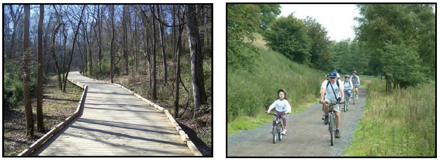
(F)
Greenbelt. Greenbelts run along the perimeter of a neighborhood, and serve to buffer a neighborhood from surrounding non-compatible uses such as a highway corridor or industrial district, or a developed area from agricultural areas or adjacent towns. Greenbelts differ from the other types of open spaces in that they are left natural, and are not intended for recreational use.
EXAMPLES OF GREENBELTS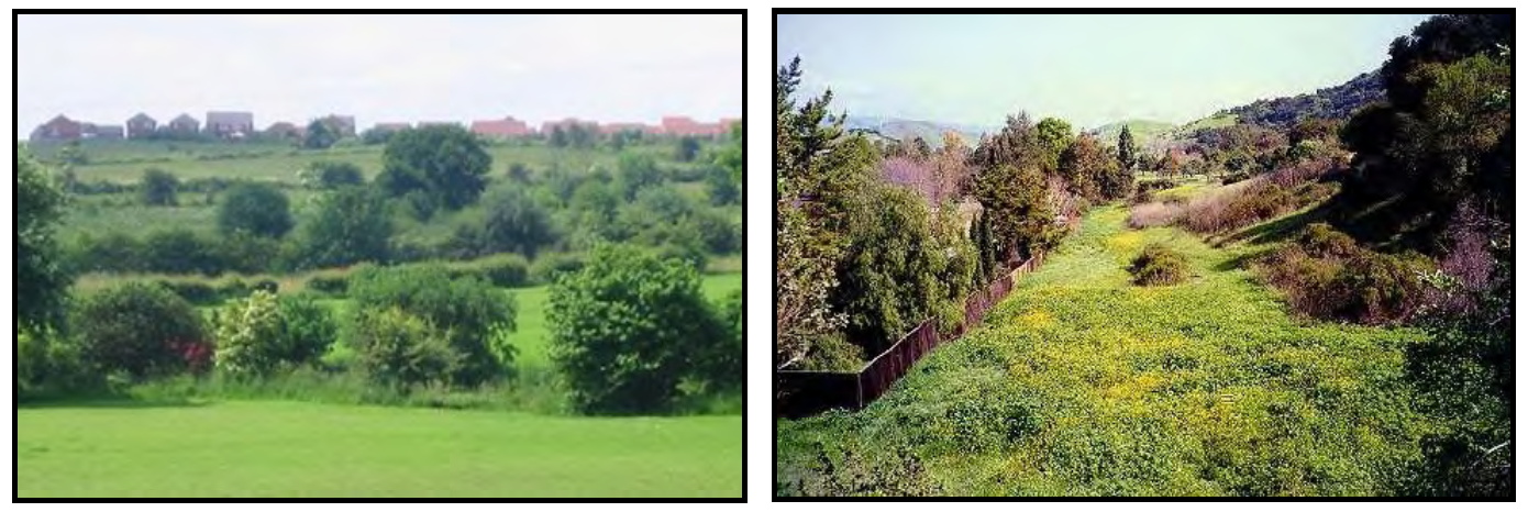
(G)
Agricultural Preserve. Open spaces designated as Agricultural Preserves shall be used for active farming in the form of crop cultivation, the keeping of livestock, or equestrian facilities. Agricultural Preserves are encouraged to protect areas of agricultural and rural heritage and promote compatible active agricultural operations.
Minimum size: 5 acres
EXAMPLES OF AGRICULTURAL PRESERVES
(H)
Nature Preserve. Open spaces designated as Nature Preserves shall be left largely undisturbed except for the optional clearing of underbrush for the provision of a walking trail (mulch or other natural material only). Nature Preserve areas are encouraged to protect large stands of trees, wildlife and natural water features. Nature Preserves are the preferred form of open space for steep slopes in excess of 25 percent grade.
Minimum size: 3 acres
EXAMPLES OF NATURE PRESERVES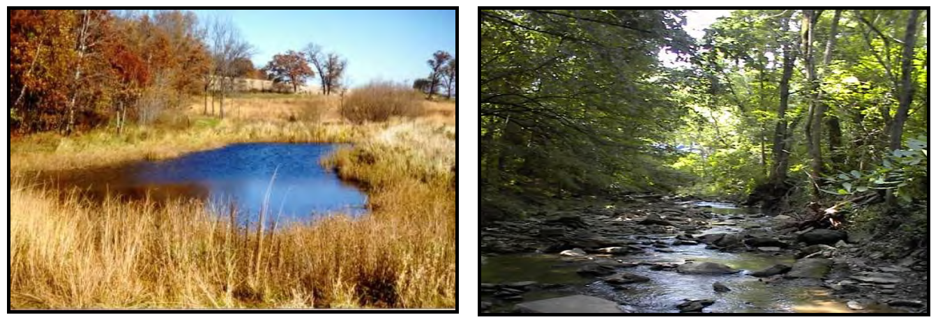
7.5.5 Open Space Ownership and Maintenance.
(A)
Open space may be owned or administered by one (1) or a combination of the following methods:
(1)
Fee simple ownership by a unit of government or private non-profit land conservancy;
(2)
Common ownership by Homeowners Association;
(3)
Split deeded ownership by individual property owners within the development;
(4)
By individual private ownership such as a farmer, developer or other private entity that maintains the open space in accordance with the purposes of this Chapter. (i.e. farming, equestrian facility).
(5)
Deed restricted open space easements on individual private properties.
(B)
The Town Board of Commissioners shall have the authority to accept or reject land dedications made as a requirement of this Section.
(C)
The owner of dedicated open space shall be responsible for the continuing upkeep and proper maintenance of the same.
(D)
In the case of common ownership by a Homeowners Association, the restrictive covenants shall provide that, in the event the Homeowners Association fails to maintain the open space according to the standards of this Ordinance, the Town may, following reasonable notice, demand that deficiency of maintenance be corrected, or enter the open space to maintain it. The cost of such maintenance shall be charged to the Homeowners Association.
(E)
The developer shall place in a conspicuous manner upon the Final Plat of the subdivision a notation concerning control of open space.
(F)
The developer will provide proof of registration of the Articles of Incorporation with the appropriate state agency for the formation of the Homeowners Association to the Administrator.
(G)
Homeowners' Associations or similar legal entities that are responsible for the maintenance and control of open space areas and common areas shall be established by the developer who shall record in the Register of Deeds a declaration of covenants and restrictions that will govern the association or similar legal entity. A copy of the recorded document shall be provided to the Administrator and such document shall include, but not be limited to, the following:
(1)
Provision for the establishment of the association or similar entity is required before any lot in the development is sold or any building occupied and membership shall be mandatory for each homeowner and any successive buyer.
(2)
The association or similar legal entity has clear legal authority to maintain and exercise control over such common open space areas.
(3)
The association or similar legal entity has the power to compel contributions from residents of the development to cover their proportionate shares of the costs associated with the maintenance and upkeep of such common areas. Further, assessments levied can become a lien on the property if allowed in the master deed establishing the homeowners association or similar legal entity.
(4)
The open space restrictions must be permanent, not just for a period of years.
(5)
The association or similar legal entity must be responsible for liability insurance, applicable taxes and the maintenance open space and other facilities under their control.
(6)
The association or similar legal entity must be able to adjust the assessment to meet changing needs.
(7)
The association shall be responsible for maintaining all public storm water drainage systems and easements within the development not being maintained by the Town, County, State or other approved entity.
(8)
It shall be expressly stated within the restrictive covenants/homeowners association documents that it will be the responsibility of the developer or successors or assigns to enforce such covenants or restrictions until such time as control has been transferred to the Homeowners Association Board of Directors. It shall be the sole responsibility of the developer, successor or assigns to correct any deficiencies prior to transfer of control over to the Homeowners Association Board of Directors.
7.5.6 Payment-in-Lieu of Dedication.
(A)
If open space within a development is physically impractical due to unusual conditions then the Town may accept a fee paid in lieu of dedication.
(B)
Fees collected in lieu of dedications and any proceeds from such transactions or sales shall be accounted for by the Town, and the funds shall be used by the Town for the purposes of acquiring and developing recreation, greenway and open space areas as shown on the land development plan or in the parks and recreation and greenway/bikeway master plans and for no other purposes. The depository for such funds may be the same as permitted other funds of the Town, pending their expenditure in accordance with the terms of this code; such funds may be invested as other funds of the Town. The Town may, at its discretion, add additional monies to the fund for the purposes of purchasing open space and recreational land to be used for recreational purposes.
(C)
Refunds shall not be granted to the developer should the project not be constructed after recording of Final Plat or if a reduction in density occurs.
(D)
Such payment in lieu of dedication shall be the product of the current assessed market value of the land to be subdivided (as established in Subsection E below) multiplied by the number of acres to be dedicated.
(E)
The current assessed market value of the gross land area of the development or subdivision at the time of submission of the required plan and/or plat shall be used to determine the land value. The current assessed market value shall be the appropriate value as determined by and maintained on file in the Rutherford County Tax Office. The average value per gross acres shall be calculated from this total tax value and applied to the required recreational land area in order to determine the land value.
TOTAL MARKET VALUE OF UNDEVELOPED PROPERTY × ACRES OF REQUIRED OPEN SPACE = PAYMENT
TOTAL ACRES OF UNDEVELOPED PROPERTY
(Ord. of 6-20-16(2))