
Haines City City Zoning Code
CHAPTER 12
TRANSPORTATION
Sec. 12.1.1. - Purpose.
Transportation, as used in the context of the Land Development Regulations, refers to general public safety and convenience criteria for streets; driveway intersection with streets; visibility at street intersections and driveways with streets; highway visual design; reservations of rights-of-way and adjacent land uses; sidewalks and pedestrian access and design and, airways/airport zoning.
Sec. 12.2.1. - Streets serving commercial development.
Streets serving commercial developments or subdivisions and accessory parking areas shall be planned to connect with arterial or collector streets so as not to generate traffic on minor streets nor to provide principal access through residential developments shall be required. The intersections of driveways from parking areas with arterial or collector streets shall be located so as to cause the least possible interference with traffic movement on the street, and shall be located not less than 100 feet from the intersection of an arterial or collector street with any other street, and shall be spaced not less than 100 feet from each other. The city commission may require marginal access streets to provide maximum safety and convenience.
(Ord. No. 24-2089, § 1(Exh. A), 11-21-2024)
Sec. 12.2.2. - Streets serving industrial development.
Streets for industrial development or subdivisions and accessory parking shall be planned to serve industrial areas exclusively and shall connect with arterial or collector streets so that no industrial traffic will be directed onto any residential street. The intersections of service streets from parking areas with arterial streets shall not be less than 100 feet from the intersection of the arterial street with any other street. Streets shall be planned to be extended to the boundaries of any adjoining land planned for industry, except for severe physical conditions or if the city commission finds such extension is not in accord with the approved plan of the area.
Sec. 12.2.3. - Streets serving residential development.
Streets serving residential developments or subdivisions shall be planned to connect with streets in adjoining residential development so as not to generate unnecessary traffic on arterial or collector streets. The city commission may require multiple cross-connection access streets to provide maximum safety and convenience.
(Ord. No. 24-2089, § 1(Exh. A), 11-21-2024)
Sec. 12.3.1. - Vehicular access control.
A.
In order to promote the safety of motorists and pedestrians and to minimize traffic congestion and conflicts by reducing the potential points of contact the following regulations shall apply:
1.
Access intended for vehicular use into and/or from a street shall not exceed 24 feet in width at the right-of-way line, except as may be approved by the administrative official.
2.
The maximum number of access drives permitted into any street shall be:
3.
No curb cut nor driveway apron shall be permitted nearer than 30 feet to any intersecting street curb or the proposed location of an intersecting street curb.
4.
There shall be a minimum of 20 feet between any curb cuts on the same street and the same property except as provided elsewhere in this chapter. There shall be a minimum of 20 feet between curb cuts on adjoining properties.
5.
In commercial and industrial zoning districts, where access into and/or from a street is intended to be used for the purpose of ingress and/or egress for tractor trailers to loading and unloading areas or docks, such access shall not exceed 40 feet in width at the right-of-way line. No driveway pavement turning radius shall begin in front of any adjoining property. Such driveway shall not be located closer than five feet to any adjoining property line.
B.
No curb cut shall be made, nor any driveway apron placed, until a permit has been applied for and issued by the administrative official. In the case of driveways requiring access to state and/or county roads, the petitioner shall secure permits from the applicable jurisdiction and submit such to the administrative official as part of the request for a development order. An applicant shall submit with their application, all necessary drawings and descriptive material as required elsewhere in the chapter for permits. No surface drainage shall run from a public right-of-way onto private property unless a public utility or drainage easement exists or is provided at that point.
C.
The city adopts and hereby makes a part of the Land Development Regulations the FDOT access management standards for the state highway system.
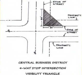
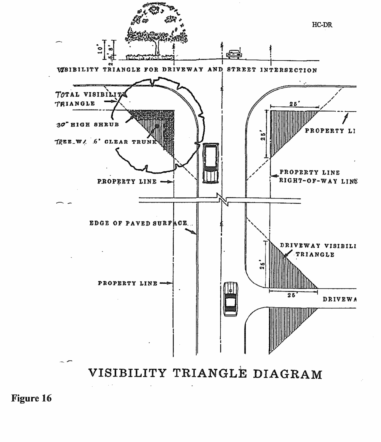
Sec. 12.4.1. - Visibility triangle.
A.
Visibility triangles, within which nothing shall be erected, placed, parked, planted or allowed to grow in such a manner as materially to impede vision between a height of two and ten feet above the center lines of intersecting thoroughfares, shall be provided as follows:
1.
Street intersections. Beginning at the intersection of street rights-of-way (property line), projected where rounded, thence in each direction along adjoining rights-of-way for a distance of 25 feet, the thence connected in a straight line across the property to form a triangle. The administrative official may elect for a review by the Florida Department of Transportation regarding the visibility site triangle requirements for any project along state maintained roads.
2.
Intersections of driveways with streets. Beginning at the intersection of each driveway edge with the street right-of-way (property line), projected where rounded, thence along the street right-of-way for a distance of 25 feet, and thence connected in a straight line across the property to form a triangle. Where driveways are curved or intersect with the street right-of-way at other than right angles, a visibility triangle shall be provided giving equivalent visibility to drivers of cars on and entering the street. (See also the diagram on the following page.)
3.
4-way Stop Street intersections within the Central Business District. Beginning at the intersection of each street edge, projected where rounded, thence in each direction along adjoining street edge for a distance of 30 feet, the thence connected in a straight line across the property to form a triangle.
(Ord. No. 10-1388, § 2, 12-18-2010; Ord. No. 23-2041, § 1(Exh. A), 5-18-2023)
Sec. 12.4.2. - Parking at intersections.
A.
No motorized vehicles, boat trailers or any other type trailers shall be parked on public right-of-way or on private property within the visibility triangle of any street intersections, or within 50 feet of any street intersections.
Sec. 12.5.1. - Purpose.
According to the legislative intent of F.S. ch. 479, the control of signs in areas adjacent to the highways of Florida is declared to be necessary to protect the public investment in the state highways; to conserve the natural beauty of the state; to preserve and promote the recreational value of public travel; to assure that information in the specific interest of the traveling public is presented safely and aesthetically; to enhance the economic well-being of the state by promoting tourist-oriented businesses, such as public accommodations, vehicle services, parks, and recreational areas; and to promote points of scenic, historic, cultural and educational interest. Therefore, signs adjacent to the state highway system are to regulated in conformance with chapter 7 of the Land Development Regulations.
Sec. 12.6.1. - Intent.
In order to accomplish the intent and purposes of the city comprehensive plan, right-of-way reservation requirements have been established for streets and the proposed thereof within the city as set out in this article.
Sec. 12.6.2. - Right-of-way reservations.
A.
Where no yard requirements are set out for a zoning district, no building or structure or any part thereof, sign, canopy or parking area shall extend streetward beyond the right-of-way reservation line, except as specifically set out in the Land Development Regulations. In case of conflict between these minimum requirements and other requirements contained in the LDR or other city requirements, codes and ordinances, the most restrictive regulations shall apply.
B.
All development orders which require site plan and/or impact review or subdivision plat approval shall reserve right-of-way in compliance with the needs identified in the transportation corridor reservation index.
C.
The right-of-way needs as identified in the transportation corridor reservation index below may be modified for state and county roadways in accordance with the right-of-way plans, specific design requirements, construction plans, or recommendations of the Polk County Metropolitan Planning Organization, Polk County Engineering Department or the Florida Department of Transportation.
D.
Generally, one-half of the right-of-way shall be reserved, measured from the centerline, unless property on both sides of the affected right-of-way is the subject of a development order request as identified in 12.6.2.B., in which case the full width of the right-of-way shall be reserved.
E.
The reserved right-of-way shall be reserved for future purchase for roadway use, and shall be kept free and clear of all associated private development improvements, including but not limited to off-street parking, landscaping other than ground cover or grass, drainage, signage and structures.
F.
All minimum yards required by the Land Development Regulations shall be measured from the reserved right-of-way line.
G.
In all commercial and industrial zoning districts, no building or other structure shall be erected within 35 feet of the center line of any street where a greater setback has not been established as set out below.
H.
Existing nonresidential structures which fall within the limits of the right-of-way reservation as listed in the transportation corridor reservation index may be renovated, provided the cost of the renovation does not exceed 20 percent of the appraised value of the structure according to the latest tax record of the Polk County Property Appraiser's Office. The cost of the proposed renovation shall be certified by a licensed general contractor employed by the property owner.
I.
No restriction shall be placed upon the renovation of an existing residential structure which fall within the limits of the right-of-way reservation as listed in the transportation corridor reservation index.
J.
Ownership of the reserved right-of-way shall be retained by the property owner.
Sec. 12.6.3. - Dedications required.
A.
The city may, as a condition to the approval of a site plan and/or impact review or subdivision plat, require the dedication by deed of the additional right-of-way necessary to implement the right-of-way needs identified in the transportation corridor dedication index where a finding is made that the following rational nexus criteria is present:
1.
The affected roadway is functioning below the acceptable level of service (LOS) as defined by the comprehensive plan, and the increased traffic impacts related to the proposed development will further degrade the operating condition of the affected roadway, or the increased traffic impacts related to the proposed development reduce the LOS at which the affected roadway is currently operating; and
2.
The improvement of the affected roadway or intersection is scheduled in the five-year capital improvements plan of the city, county or state.
(Ord. No. 10-1388, § 2, 12-18-2010)
Sec. 12.6.4. - Transportation corridor dedication index.
A.
The city commission hereby adopts the right-of-way transportation corridors dedication index for certain roadways within the corporate limits. This index shall be comprised of the streets listed in the setback lines section of the existing zoning ordinance and any amendments that may occur after adoption of the LDR.
B.
Upon adoption of the transportation corridor dedication index, the transportation corridor dedication index shall be effective for a period of five years from the date of adoption of the LDR. If the city, county or state has not acquired all of the right-of-way within the limits of the transportation corridor, the city shall invalidate the transportation corridor dedication index. However, the city shall have the right to extend the effective period of the transportation corridor dedication index for additional five-year periods after holding a public hearing in accordance with the requirements to amend the LDR.
C.
The below list of roadways and their established right-of-way reservation needs constitute the transportation corridors dedication index. Right-of-way dedication lines are determined to be the distances from the center line of the street right-of-way.
1.
Harrison Drive—50 feet.
2.
Avenue F—30 feet.
3.
Polk City Road—50 feet.
4.
Palmetto Street—50 feet.
5.
Citrus Boulevard—25 feet.
6.
Johnson Avenue—60 feet.
7.
Jones Avenue—35 feet.
8.
U.S. 17-92 from the west city limits to the Peninsular Drive intersection—74 feet.
9.
U.S. 17-92 from the Peninsular Drive intersection east to the railroad bridge underpass—60 feet.
10.
U.S. 17-92 from the railroad bridge east and north to Citrus Avenue intersection—60 feet.
11.
Hinson Avenue east of U.S. 17-92—60 feet.
12.
Grace Avenue—50 feet.
13.
Proposed east-west collector, designated number 12 in comprehensive plan—50 feet.
14.
Scenic Highway, S.R. #544—60 feet.
15.
Kentucky Street—50 feet.
16.
U.S. 27 from U.S. 17-92 interchange north to Polk City Road interchange—65 feet.
17.
U.S. 27 from Polk City Road intersection north to the north city limits—75 feet.
18.
U.S. 27 from U.S. 17-92 intersection south to south city limits—75 feet.
19.
Peninsular Drive—40 feet.
20.
Azalea Drive—50 feet.
21.
Fifth Street south of U.S. 17-92 intersection—50 feet.
22.
Fifth Street north of U.S. 17-92 intersection—35 feet.
23.
Ponce De Leon Boulevard—50 feet.
24.
Railroad Avenue north to Seventh Street intersection—35 feet.
25.
Seventh Street north of railroad and north to Citrus Boulevard—35 feet.
26.
Tenth Street south of U.S. 17-92 to south city limits—50 feet.
27.
Tenth Street north of U.S. 17-92 NORTH TO Lily Avenue—30 feet.
28.
Tenth Street north to Avenue F north to north bypass—30 feet.
29.
Eleventh Street north to Citrus Avenue intersection north to Avenue—30 feet.
30.
Old Dixie Highway—50 feet.
31.
Twenty-second Street north of Grace Avenue north to Hinson Avenue intersection—50 feet.
32.
Thirtieth Street—50 feet.
(Ord. No. 10-1388, § 2, 12-18-2010)
Sec. 12.7.1. - Sidewalks.
A.
Sidewalks shall be required on both sides of the street. Sidewalks shall be required on both sides of all arterial, collector, or local street.
B.
Sidewalks shall be a minimum of five feet wide and four inches thick along all local residential streets. At driveways, sidewalks shall be six inches thick and reinforced with No. 10, six- by six-inch woven wire fabric or equivalent steel rebars. Sidewalks shall be constructed at the property line. All plans and specifications shall be included with final construction plans and will require approval by the city staff. Expansion joints shall be provided adjacent to all cold joints.
C.
Sidewalks shall be constructed after all other subdivision site improvements have been completed and concurrent to dwelling or other buildings being constructed.
D.
Sidewalks shall be a minimum of six feet wide and four inches thick along all collector and arterial streets. At driveways, sidewalks shall be six inches thick and reinforced with No. 10, six- by six-inch woven wire fabric or equivalent steel rebars. Sidewalks shall be constructed at the property line. All plans and specifications shall be included with final construction plans and will require approval by the city staff. Expansion joints shall be provided adjacent to all cold joints.
(Ord. No. 09-1346, § 20, 8-6-2009; Ord. No. 18-1594, § 6, 3-1-2018; Ord. No. 23-2041, § 1(Exh. A), 5-18-2023)
Sec. 12.7.2. - Service easements.
A.
Where pedestrian and service easements are provided, the city commission may require paved walkways, drainage, or other improvements therein, to be constructed in accordance with plans and specifications approved by the city staff.
Sec. 12.8.1. - Airport zoning.
A.
Although there are no airports located within the corporate limits, when reviewing request for development orders, the city will comply with applicable provisions of F.S. ch. 333, Airport Zoning.