
Haines City City Zoning Code
CHAPTER 6
SPECIAL PROVISIONS
Sec. 6.1.1. - General.
The special districts for which regulations are established in this article are:
a)
Of a nature involving a regulatory form not adapted to presentation in the zoning ordinance schedule of district regulations; and/or
b)
Intended for future application as the need and opportunity arises. Boundaries for these districts will be established on the official zoning map by amending action. Until such action, it is intended to leave lands which might in the future be encompassed by such planned unit development boundaries in more traditional classifications indicated on the official zoning map, since the boundaries of such planned unit development districts cannot be fixed as to location in advance of petition and amendment.
A.
Intent.
1.
Within districts now existing or which may hereafter be created, it is intended to permit, on application and on approval of required site, use, building and development plans, establishment of new planned unit development (PUD) districts for specialized purposes where tracts suitable in location, area and character for the uses and structures proposed are to be planned and developed as units. Suitability of such tracts for the plans and development proposed for the PUD district shall be determined by consistency with the city comprehensive plan and the existing and prospective character of surrounding development.
2.
Within PUD districts, regulations adapted to such unified planning and development are intended to accomplish the purposes of zoning and other applicable regulations to the same degree as in districts in which regulations are intended to control development on a lot-by-lot rather than a unified basis, and to promote economical and efficient land use, an improved level of amenities, appropriate and harmonious variety in physical development, creative design, and a better urban environment.
3.
In view of the substantial public advantages of planned unit development, it is the intent of these regulations to promote and encourage development in this form, where appropriate in location and character, and to further the purposes of the comprehensive plan.
B.
Relation of PUD regulations to general zoning, subdivision or other Land Development Regulations.
1.
The provisions which follow shall apply general to the creation and regulation of all planned unit development districts. Where there are conflicts between the special PUD provisions herein and general zoning, subdivision or other Land Development Regulations or requirements, these special regulations shall apply in PUD districts unless the governing body shall find, in the particular case:
a.
That provisions herein do not serve public purposes to a degree at least equivalent to such general zoning, subdivision or other Land Development Regulations or requirements, or
b.
That actions, designs, or solutions proposed by the petitioner, although not literally in accord with these special regulations or general regulations, satisfy public purposes to at least an equivalent degree. It is specifically provided, however, that where land use intensity ratings, densities or floor area and similar ratios have been established by this chapter, the city commission shall not act in a particular case to increase the land use intensity rating of property, or similar ratios nor increase the established maximum permitted densities.
2.
Except as indicated above, procedures and requirements generally in effect, those set forth herein, and in guides and standards adopted as part of these regulations for particular classes of PUD districts, shall apply in PUD districts and to amendments for such districts and issuance of development orders, building permits and certificates of occupancy therein.
C.
Planned unit development defined. For purposes of this chapter, a planned unit development is:
1.
Land under unified ownership and control to be planned and developed as a whole, in a single development operation or a programmed series of development operations, including all lands and buildings, and within a specified time frame;
2.
For principal and accessory structures and uses substantially related to the character of the district and in compliance with the comprehensive plan;
3.
According to master plans which include not only streets, utilities, lots or building sites, but also site plans, floor plans and typical elevations for all buildings as intended to be located, constructed, used and related to each other, and plans for other uses and improvements on the land as related to the buildings; and
4.
With a program for provision, operation and maintenance of such areas, facilities and improvements as will be for common use by some or all of the occupants of the district but will not be provided, operated or maintained at general public expense.
D.
PUD districts—Where permitted.
1.
Planned unit development districts. A PUD may hereafter be established by amendment to the official zoning map where tracts suitable in location and character for the uses and structures proposed are to be planned and developed as units, according to the requirements and procedures herein set forth. PUD districts shall be appropriately located with respect to intended functions, to the pattern and timing of development existing or proposed in the city comprehensive plan, and to public and private facilities, in compliance with the city concurrency management system. The following specific requirements shall be met:
2.
Relation to major streets. Except as specifically provided in regulations for particular classes of planned unit development districts, PUD districts shall be so located with respect to arterial or collector streets or provide direct access to such districts without creating traffic along minor streets in residential neighborhoods outside the districts.
3.
Relation to utilities, public facilities and services.
a.
PUD districts shall be so located in relation to sanitary sewers, water lines, storm and surface drainage systems and other utility systems and installations that neither enlargement nor extension of such systems will be required in manner, form, character, location, degree, scale or timing not in keeping with the provisions of the concurrency management system.
b.
Such districts shall be located with respect to necessary public facilities (as for example schools, parks, and playgrounds in the case of planned unit developments of a residential character) as to have access to such facilities in keeping with the provisions of the concurrency management system.
4.
Minimum Residential Planned Unit Development (RPUD) standards as follows:
a.
Minimum RPUD Standards and Policy
During the zoning phase of any proposed development, should the Developer request lot sizes less than 60' in width and 110' in depth, the following standards shall be required:
RPUD - MINIMUM DEVELOPMENT STANDARDS
b.
Development Policy:
i.
All new Residential Development shall install reuse water lines or dry reuse lines until reuse water is available.
ii.
A variety of lot sizes are required. The maximum ratio of 52 feet lots shall be 60 percent and the minimum ratio of 60 feet lots shall be 20 percent and 70 feet lots shall be 20 percent. The extra lot width required under section 13.3.6 shall be excluded from calculating the minimum lot width.
5.
Specifically the preliminary plans shall include, but are not necessarily limited to:
c.
A Traffic Study, that identifies the impact and mitigation of the proposed development on the existing transportation network. The Study shall include a proposed major internal street plan for the site demonstrating proposed traffic flow to access points and thoroughfares outside the proposed development and relationships thereto, and any requirements for new streets or improvements that may be required outside the project as a result of the development of the project. The proposed major street plan should show the concept for internal access and traffic flow and how it is proposed to separate vehicular and pedestrian traffic within the project. The petitioner may submit as a part of this traffic concept plan such proposals as may be deemed necessary for a pedestrian system or otherwise for the movement of persons by means other than privately owned passenger vehicles.
E.
Physical character of the district site.The site within the proposed PUD district shall be suitable for development in the manner proposed without hazards to persons or property, on or off the tract, from probability of flooding, erosion, or other dangers, annoyances, or inconveniences. Condition of soil, ground water level, drainage, and topography shall all be determined to be appropriate to both kind and pattern of use intended.
F.
Procedures on PUD amendments.
1.
Applications; materials to be submitted. Petitions for PUD amendments shall be submitted as for other zoning district amendments. All such petitions shall be accompanied by a fee to be set by the city commission to offset the cost of administration, publications, notices, and related activities required by this chapter and applicable provisions of the Land Development Regulations. Materials submitted with the petition or on subsequent request by the planning commission or city commission shall include all plans, maps, studies and reports which may be required to make the determinations called for in the particular case, with sufficient copies for necessary referrals and records.
2.
In particular, there shall be supplied a report identifying all property owners within the area of the proposed district and giving evidence of unified control of its entire area. The report shall state agreement of all present property owners:
a.
To proceed with the proposed development according to regulations existing when the map amendment creating the PUD district is passed, with such modifications as are set by the city commission and agreed to by the petitioner at the time of amendment;
b.
To provide agreements, contracts, deed restrictions, and sureties acceptable to the city for completion of such development according to approved plans, and for continuing operation and maintenance of such areas, facilities, and functions as are not to be provided, operated or maintained by general public expense;
c.
To establish a specified time frame for commencing and accomplishing the development, and;
d.
To bind their successors in title to any commitments made under 6.1.1.F.2.a., b, or c above.
3.
Petitioners shall submit a survey or surveys at a scale of 1:100 or less, indicating boundaries and ownership of all properties involved, ownership of adjoining properties, topography with contours at a maximum of two-foot intervals (except for parcels of 50 acres or more in which case five-foot contour intervals are acceptable for the concept plan), physical features, water, if any, conditions of soil, subsoil, other natural features and vegetative cover indicated in sufficient detail to describe suitability of the site for proposed uses and structures.
4.
Petitioners shall submit a master development plan at a scale of not less than 1:100 related to the surveys and conditions above, which plan as submitted with the petition may be a preliminary general plan, to be developed and modified during further proceedings, into detailed final form. The preliminary plan shall indicate generally the approximate locations of all proposed buildings, typical building floor plans and elevation sketches and the uses intended for each building and of the total development; the approximate location and dimensions of all the streets, drives and parking and loading areas; open space designations (golf courses, parks, and the like); recreational facilities and service areas, the neighborhood commercial service areas, if a part of this project; tabulations of total gross acreage in the development and percentages devoted to open space, impervious surfaces and other uses. Such tabulations shall be based upon the land use intensity (LUI) formulas stated below. If the petitioner deems it necessary, they may submit analysis comparing the proposed development in various aspects with conventional approaches to development.
5.
Specifically the preliminary plans shall include, but are not necessarily limited to:
a.
Title of the proposed preliminary planned unit development and the name of the developer and the professional project planner.
b.
Scale, date, north arrow, and general site location map, showing particular relationships to such external facilities as thoroughfares, shopping areas, cultural complexes, existing utilities and related land uses.
c.
A proposed major internal street plan for the site demonstrating proposed traffic flow to access points and thoroughfares outside the proposed development and relationships thereto, and any requirements for new streets or improvements hat may be required outside the project as a result of the development of the project. The proposed major street plan should show the concept for internal access and traffic flow and how it is proposed to separate vehicular and pedestrian traffic within the project. The petitioner may submit a s a part of this traffic concept plan such proposals as may be deemed necessary for a pedestrian system or otherwise for the movement of persons by means other than privately owned passenger vehicles.
d.
A general drainage plan for the development, related particularly to the city's master drainage plan.
e.
General plans for sanitary sewer, water, and other utilities.
f.
Calculations of the projected potable water demand, sanitary sewer to be generated, solid waste to be generated, recreation demands, traffic generations, both background and on site, and drainage needs, all prepared using the city adopted level of service standards as the basis for the projections.
g.
The plan shall show off-street parking arrangements at not less than two parking spaces per dwelling unit, in the case of a residential planned unit development with additional spaces for recreation facilities and other permitted uses at ratios as required by such uses in other applicable city zoning district classifications. Commercial planned unit development (CPUD) permitted uses shall provide off-street parking and loading as required in the applicable commercial zoning districts; industrial planned unit development (IPUD) permitted uses shall provide off-street parking and loading spaces as required in the applicable industrial zoning districts. Actual individual spaces need not be delineated on the concept plan, but general areas and methods of treating off-street loading areas relative to the project development shall be illustrated.
h.
A statement showing in what respects the concept plan serves the public interest to a better degree than zoning currently on the property proposed for planned unit development.
i.
A statement showing the overall floor area for permitted principal and customary incidental uses proposed for the land area covered by the petition which shall not exceed the land use intensity (LUI) ratings set out in the article.
j.
In addition, and as part of the report described above, petitioners shall submit a preliminary plan for the development and detailed proposals in accord with the above provisions as a basis for specific agreements concerning plans, programs, instruments, or specific modifications of details of the PUD or other zoning, subdivision or other land development regulation(s), where it is alleged by the applicant that such modification serves public purposes to an equivalent degree.
k.
An impact statement meeting the applicable requirements of chapter 6 of the administration and procedures manual.
G.
Planning commission procedures. On petitions for PUD amendments, the planning commission shall proceed in general as for other zoning amendments, but shall give special consideration to the below matters and shall allow changes in original applications as indicated herein.
1.
The planning commission shall follow the procedures and notice for all land use changes.
2.
The planning commission shall include with its recommendation at least following findings:
a.
Suitability of the tract for the requested use and design;
b.
Compatibility with the adopted comprehensive plan;
c.
Compliance with the concurrency requirements; and
d.
Provision of this section and the Land Development Regulations have been met; and
3.
Based upon such findings the planning commission shall recommend approval of the PUD as proposed, approval with stipulated conditions; or disapproval.
H.
Pre-hearing conferences with petitioners.
1.
On request by petitioners, the administrative official and city staff shall meet with petitioners to review the original application, including the report and the preliminary plan submitted with the report. The purpose of such pre-hearing conferences shall be to assist in bringing the report, and the preliminary plan as nearly as possible into conformity with these or other regulations applying in the case, and/or to define specifically those variations from application of general regulations which would otherwise apply, which appear justified in view of equivalent service of the public purposes of such regulations.
2.
In the course of such pre-hearing conferences, any recommendation for changes shall be recorded in writing, and shall become part of the record in the case. All such recommendations shall be supported by stated reasons for the proposal for zoning change. Petitioners shall in writing, indicate their agreement or disagreement to such recommendations. If there is disagreement, petitioners shall in writing indicate their reasons therefore. Responses by petitioners shall also be included in writing and made a part of the petition.
3.
A pre-application conference with preliminary plans before the technical review board is required. All recommendations shall become a part of the record and shall require a written response from the applicant.
I.
Public notice and hearing. At such time as further conferences appear unnecessary, or at any time on request of the petitioner, public notice shall be given and hearings before the planning commission held as for other amendments, but the notice and hearing shall be on the petition as it may have been amended following the pre-hearing conferences rather than as originally submitted.
J.
Planning commission recommendations to city commission. The petition shall be deemed to be dated and the matter submitted to the planning commission as of the date the petitioner requests preparation of such recommendations. Such recommendations shall include findings:
1.
As to the suitability of the tract for the general type of PUD district proposed in terms of consistency with the city comprehensive plan, physical characteristics of the land and its relation to the surrounding area and existing and probable future development;
2.
As to relation to major transportation facilities, utilities, public facilities and services and compliance with the concurrency management system;
3.
As to adequacy of evidence of unified control and suitability of any proposed agreements, contracts, deed restrictions, sureties or other instruments, or the need for such instruments or for amendments in those proposed;
4.
As to the suitability of preliminary plans or the desirability of amendments; and
5.
As to desirable specific modifications in PUD or general regulations as applied to the particular case, based on determination that such modifications are necessary or are justified in the particular case upon demonstration that the public purposes of PUD or general regulations as applied in the particular case would be met to at least an equivalent degree by such modifications.
6.
Based on such findings, the planning commission shall recommend approval of the PUD amendment as proposed; approval conditioned on stipulated modifications; or disapproval.
K.
Action by city commission.
1.
On petition for PUD amendments, the city commission shall proceed in general as provided for in other zoning district amendments. The city commission may grant the petition in accord with PUD and general regulations, may include recommended specific modifications of the PUD or general regulations as recommended by the planning commission, or may deny the petition. If proposed action is substantially at variance with planning commission recommendations, such proposed changes shall be referred to the planning commission for review and report prior to final city commission action. Unless the planning commission reports within 30 days of such referral, or such longer periods as may be set in the case by the city commission, if agreed to be the petitioner, the city commission may proceed to final action without further delay.
2.
If the city commission grants the amendment, in any form, the development shall be required to be in accord with final plans meeting the requirements of this chapter, as specifically supplemented or modified by the city commission in the particular case, and shall conform to time limitations established by the city commission on beginning and completion of the development as a whole or in specified stages or phases.
3.
Before development may proceed, agreements, contracts, deed restrictions and sureties shall be in form approved by appropriate officers or agencies involved in the review process. The city commission may, in its amending action, approve preliminary plans in whole or in part or may indicate required changes, and such approval or requirements shall be binding in determinations concerning final development plans.
L.
Approval of final plans.
1.
Once initial approval is granted by the city commission, an applicant has six months to submit a final master plan meeting all the requirements to the technical review board for its approval. the technical review board shall approve or deny the request for final approval stating any reasons for denial. Once approved by the technical review board the final plans shall be placed on the regular agenda of the city commission for their final approval and shall be valid for one year from the date of approval. In the event a final master plan expires, the administrative official, in his discretion, has the authority to grant two six-month extensions upon receipt of written explanation as to reason for failure to proceed with project.
2.
After lands are rezoned to PUD status, no building permit, or certificate of occupancy shall be issued in such districts unless and until the city staff have reviewed final plans and reports for the development as a whole or stages or portions thereof deemed satisfactory in relation to total development. No structure or use other than as indicated in approved final plans and reports shall be permitted.
3.
Approval of final plans and reports shall be based on compliance with regulations applying at the time the land was zoned to PUD status, including such specific modifications as made by the city commission in the amending action or, at the option of applicant, in accordance with regulations currently in effect. Upon approval of final plans and reports, building permits are to be issued in the same manner as for building permits generally, provided that any requirements concerning the order or location in which building permits are to be issued in the particular PUD district shall be observed. Except as provided below, final plans and reports approved shall be binding on the petitioner and any successors in interest so long as PUD zoning applies to the land.
M.
Planning commission action following rezoning to PUD status.
1.
Changes in approved final plans. Minor changes may be permitted by the Planning commission or its duly authorized agent on petition by the original petitioner or successors in interest, but only on a finding that such changes are in accord with all applicable regulations in effect at the time the final plan was approved and the general intent and purpose of the city comprehensive plan in effect at such time; provided, that the petitioner may elect to proceed in accord with the city comprehensive plan currently in effect. Changes other than as indicated above shall be made only by new PUD or other amendments.
a.
Minor changes to approved preliminary or finally approved plans may be permitted without a public hearing if the following criteria are met:
1.
Change does not increase the intensity of an approved land use;
2.
Change does not increase the residential density more than one percent;
3.
Change does not redesign or alter the projects character.
4.
Change does not create a new land use.
b.
All other changes shall for the same procedures as for a new application.
2.
Advertised public hearings permissible but not mandatory in connection with final plans. Action in connection with approval of final plans or changes in approved plans not requiring amendments are administrative, and do not require public notice and hearing but the planning commission may hold such hearings as it deems desirable in connection with such action.
N.
Expiration of time limits on PUD amendments.
1.
If development actions required in the amendment are not taken within time limits set, the planning commission shall review the circumstances and recommend to the city commission that:
a.
PUD zoning for the entire area be continued with revised time limits;
b.
PUD zoning be continued for part of the area with revised time limits, and the remainder rezoned to an appropriate category in compliance with the comprehensive plan; or
c.
The entire area be rezoned from PUD to an appropriate category in compliance with the comprehensive plan.
2.
Such recommendations shall include proposals for appropriate action in respect to any legal instruments in the case.
(Ord. No. 09-1346, § 12, 8-6-2009; Ord. No. 21-1724, § 1(Exh. A), 2-18-2021; Ord. No. 21-1732, § 1(Exh. A), 6-17-2021; Ord. No. 23-2041, § 1(Exh. A), 5-18-2023)
Sec. 6.1.2. - Reserved.
Editor's note— Ord. No. 21-1761, § 1(Exh. A), adopted October 21, 2021, repealed § 6.1.2, which pertained to land use intensity (LUI) and derived from original code.
Sec. 6.1.3. - RPUD—Residential planned unit development districts.
A.
The following regulations and requirements apply to planned developments primarily for housing but with accompanying related services:
1.
RPUD—Residential planned unit development defined. A RPUD is defined for the purposes of this chapter as a planned unit development (as defined general in 6.1.1.C.) primarily for dwellings and related uses, services and facilities and containing not less than four acres.
2.
RPUD districts, where permitted. RPUD districts may hereafter be established within areas currently classified as Residential on the future land use map of the city comprehensive plan by amendments to the official zoning map in accordance with the provisions set forth general for PUD districts in 6.1.1.D. above.
3.
Permitted principal and accessory uses. Principal uses permitted shall include dwellings, including residential design manufactured homes (RDMH), which may be single family or two-family detached, semi-detached or attached, and/or multi-family, churches, schools, parks and playgrounds and governmental structures. Manufactured housing development, containing RDMH and standard design manufactured homes (SDMH) shall be permitted, provided however, that all residential lots on the perimeter of the district shall contain only RDMH manufactured homes meeting all appearance criteria.
Accessory uses permitted shall include only those which are customarily accessory and incidental to residential developments. Floor area devoted to accessory uses other than parking shall not exceed 20 percent of residential floor area, and provided that in planned residential developments having 100 or more dwelling units, establishments for sale of convenience goods, personal and professional service establishments, and eating and drinking establishments shall be permitted as accessory uses. Such establishment shall be designed and scaled to meet only the requirements of occupants of dwelling units in the planned development and their guests, and there shall be no external evidence of such establishments visible from outside the planned development.
4.
Other uses.
Short term rental units. The rental of a dwelling for less than 30 days in a residential district when the use is listed and approved as with the RPUD residential district and shall also meet the following minimum criteria:
(a)
Minimum project size: Two acres and at least 12 dwelling units.
(b)
Roadway access: Direct access to a collector or arterial road.
(c)
Buffer: All short term rental developments shall be separated on each side from areas which have not been approved for short term rental or time-share dwelling use by a 15-foot or wider common area buffer with dense vegetation or buffer and wall at least six feet high. A waiver to the size of the buffer may be granted by the city commission when the short term rental development is adjacent to a nonresidential district.
(d)
Location within mixed developments: All short term rental developments which have one or more sections approved for short term rentals and one or more sections not approved for short term rentals or time-share dwellings shall locate the sections approved for short term rentals and time-share dwellings in the front of the development or shall provide separate driveway access to such sections.
(e)
Project security: All short term rental development sections approved for short term rentals shall be provided with security gates at all private street or driveway entrances and exits to such sections.
(f)
Fire standards: All short term rentals shall comply with fire code standards for commercial structures and have adequate smoke alarms and fire extinguishers.
(g)
Property owners association: All short term rental developments shall be subject to a property owners association which is responsible for suitably maintaining all common area buffers and which has the authority to assess all property owners for common area buffer maintenance expenses.
(h)
Conversions: All short term rental developments involving a conversion of existing dwellings to short term rental residential units shall not be approved unless at least 80 percent, or the more restrictive standard in any specific property regulations controlling the property (example: association documents), of the owners in the development demonstrate acceptance of the conversion in a manner suitable to the city attorney.
(i)
Sales contracts: All sales contracts involving the sale of lots or dwelling units in short term rental developments shall indicate in bold red type that residential lots in the development may be used for short term rental residential units.
(j)
Other conditions: All short term rental developments shall comply with any other conditions deemed necessary and just.
5.
Density. Maximum residential density is regulated by the LUI rating scale and the provisions of 6.1.2.B. of the LDR.
6.
Site planning, external relationships. Site planning within the district shall provide protection of the development from potentially adverse surrounding influences, and protection of surrounding areas from potentially adverse influences within the district. In particular:
a.
Principal vehicular access points shall be designed to encourage smooth traffic flow and minimum hazards to vehicular or pedestrian traffic. Merging and turn-out lanes and/or traffic dividers shall be required where existing or anticipated heavy traffic flows indicate need. In general, minor streets shall not be connected with minor streets outside the district in such a way as to encourage through traffic, or flow of traffic from the district along minor streets in neighboring residential areas.
b.
Uses adjacent to conventional single family residential developments. Where a RPUD district adjoins a single family residential development without intervening permanent open space at least 100 feet in width serving as separation for buildable areas, the portion of the district so adjoining shall be planned and developed only for uses permitted in the adjoining residential development except as provided for herein and in accordance with all other requirements for the district.
A second option in lieu of such common boundary development, shall be the provision of open space for the district with a minimum depth of 25 feet between the common zoning district boundaries may be permitted. No intensive recreational use or off-street parking shall be permitted in this open space setback area. Such area may be required to be maintained in landscaping including trees, shrubs, ground covers and grass for a minimum depth of ten feet.
A third option available to the developer is the provision of a solid screening material such as a wooden fence or block wall, each of which shall be six feet in height and place a minimum of ten feet from the property line. The ten-foot setback area between the zoning district boundary and the solid screening shall be grassed and landscaped and maintained in good condition at all times. Such areas shall be undeveloped other than landscaping, contain no accessory buildings and treated as front yards for the district.
c.
Fences, walls, or vegetative screening within and at the edges of RPUD districts shall be provided where needed to protect residents from undesirable views, lighting, noise or other adverse off-site influences, or to protect residents of adjoining properties from similar adverse influences within the district. In both cases, screening shall at a minimum be designed to protect from existing or potential first floor residential window levels. In particular, parking areas for five or more cars, service areas for loading or unloading vehicles other than passengers, and areas for storage and collection of trash and garbage shall be so deemed.
d.
Height limitations at edges of RPUD districts. Except along boundaries where adjoining districts permit greater heights within similar areas, or where the district adjoins, with or without an intervening street, a waterway or other permanent open space at least 100 feet in width, in addition to the height limitations applying generally within RPUD districts, the following shall apply: No portion of any structure within the district shall project through imaginary planes leaning inward from district boundaries at an angle representing an increase of one foot in height for each three feet of horizontal distance and shall not exceed a maximum of 35 feet in height above grade except upon making provisions to install approved automatic sprinkler system.
e.
Sign limitations. Two permanent identification signs, not exceeding 20 square feet in area, may be erected at each principal entrance to the planned development district. During the process of development, the planning commission may permit the erection of not to exceed one temporary sign at each principal entrance, provided that no such sign shall exceed 30 square feet in area, and that the planning commission shall establish a time limit for its display and shall indicate appropriate placement.
7.
Preservation and protection of desirable natural features and protection against erosion by wind or water. Planning and development shall preserve and protect desirable natural features and protect against environmental damage. In particular, desirable existing trees and other vegetation shall be preserved, and along water fronts the disturbance of terrain or vegetation in a way which is likely to increase water erosion within or adjacent to the district shall be prohibited.
8.
Site planning, internal relationships, general. The site plan shall provide for safe, efficient, convenient and harmonious grouping of structures, uses and facilities, and for appropriate relation of space inside and outside buildings to intended uses and structural features. In particular:
a.
Streets, drives, parking and service areas shall provide safe and convenient access to dwelling units and project facilities, and for service and emergency vehicles, but streets shall not be so laid out as to encourage outside traffic to traverse the development on minor streets, nor occupy more land than is required to provide access as indicated, nor create unnecessary fragmentation of the development into small blocks, nor shall streets be so laid out or constructed as to require excessive cuts or fills or to interfere with desirable drainage in or adjacent to the district.
b.
Vehicular access to streets.
1.
If the street serves 50 dwelling units or less, vehicular access from off-street parking and service areas may be directly to the street from dwelling units. Determination of number of dwelling units served shall be based on normal routes of traffic anticipated in the development.
2.
Vehicular access to other streets from off-street parking and service areas shall be so combined, limited, located, designed and controlled as to channel traffic from and to such areas conveniently, safely, and in a manner which minimizes marginal traffic friction and promotes free traffic flow on streets without excessive interruptions.
3.
Visibility triangles shall be maintained as provided in chapter 12 of the LDR.
9.
Petition and materials for RPUD. See 6.1.1.C.
10.
Increases or decreases in minimum areas required for RPUD districts in particular cases.
a.
Lesser areas than those generally required may be recommended to the city commission for RPUD zoning upon findings by the planning commission in a particular case that special circumstances justify such reductions, and that other requirements can be met in such lesser areas.
b.
Greater areas than those generally required may be recommended to the city commission for RPUD zoning upon findings by the planning commission in a particular case that the plan of development as proposed, or the characteristics of the property involved, in themselves or in relation to environmental circumstance, require such increase to meet the requirements and intent of RPUD zoning and provide an efficient use of land or to provide necessary special protections.
11.
a.
RPUD - Minimum Development Standards—Effective October 4, 2022.
12.
Maximum impervious surface coverage by all uses. The maximum impervious surface coverage permitted for all structures, paved parking areas, streets and similar site improvements shall not exceed 60 percent of the district area or for individual parcels within the district.
13.
Repeal or modification of Residential Planned Unit Development approval if construction not commenced.
An approved Residential Planned Unit Development (RPUD) plan shall remain valid, provided that (i) the Preliminary Plat and Site Construction Plans have been approved, and (ii) material construction has commenced within three year(s) after the date of the RPUD Ordinance. All phases of an RPUD plan shall be included and designated with phasing lines on the RPUD Plan and the preliminary plat. Failure to timely (i) obtain approval of preliminary plat and site construction plans, and (ii) commence material construction within three year(s) after the date of the RPUD Ordinance, shall be grounds for the city, at its discretion, to initiate a rezoning of the subject property. In such event, the planning commission may recommend to the city commission that the subject property be returned to its previous zoning classification, that the RPUD be modified, or that the RPUD be retained in its current form. For purposes of this section "material construction" shall include construction of streets, drives, parking and services areas, or utility infrastructure of the RPUD.
(Ord. No. 21-1761, § 1(Exh. A), 10-21-2021; Ord. No. 22-1789, § 1, 3-17-2022; Ord. No. 22-2024, § 1, 10-4-2022; Ord. No. 23-2041, § 1(Exh. A), 5-18-2023; Ord. No. 23-2053, § 1(Exh. A), 12-7-2023)
Sec. 6.1.4. - CPUD—Commercial planned unit development districts.
The following regulations and requirements apply to planned unit developments established primarily for commercial uses on parcels of land two acres or greater in area:
A.
CPUD—Commercial planned unit development defined. A CPUD is defined for the purposes of these regulations as a planned unit development (as defined generally in 6.1.13.) primarily for general retail, commercial services and related uses and facilities.
B.
CPUD districts, where permitted.
1.
CPUD districts may hereafter be established within areas classified commercial corridor and neighborhood activity center on the future land use map of the city comprehensive plan by amendments to the official zoning map in accordance with the provisions set forth generally for PUD districts in 6.1.1.6. above.
2.
Creation of CPUD districts will be permitted where planned shopping centers are appropriate and will serve areas not already conveniently and adequately provided with commercial and service facilities of the kind proposed. It is intended to permit the establishment of such districts only where planned centers with organized buildings, service and parking areas, and open space will clearly serve demonstrated public need, reduce traffic congestion and points of conflict below that which would result from strip commercial development along roadways, and protect stability and property values in surrounding neighborhoods.
C.
Permitted principal and accessory uses.
1.
Restrictions on uses. In order to preserve the essential character of the district and to protect adjoining and nearby property, certain uses are permitted in the CPUD districts. Retail and service uses are permitted as follows:
a.
Retail such as grocery, variety, drug store, hardware and similar uses.
b.
Personal services such as barber and beauty shops.
c.
Laundry and dry-cleaning establishments, shoe repair, establishments for service and repair of household appliances, provided that no such establishment shall employ more than five persons in processing on the premises.
d.
Restaurants, including fast food types, but not including drive in restaurants.
e.
Retail outlets for sale of home furnishings and appliances, office equipment and furniture, full line department stores and similar uses.
f.
Commercial recreational facilities such as indoor motion picture theater, theater for stage productions, billiard parlor, bowling alley, and similar uses in completely enclosed buildings.
g.
Governmental uses.
h.
Shopping malls, open or enclosed with customary accessory uses.
i.
Medical marijuana dispensing facilities.
2.
Certain other uses. Service stations and boat, camping equipment, and garden supply centers are often found in shopping centers. If such activities are proposed as a part of shopping center, they must be included in the request for amendment. If outside display of products is involved, such activity shall be well away from major activity of the shopping center and properly screened. If service stations are to be permitted in a shopping center, their locations shall be a part of the amendment and they shall be so located that there will be no interference with pedestrian traffic. The requirements set out for service stations in chapter 5 of the LDR as a minimum shall apply.
3.
Accessory uses and structures.
a.
Permitted are uses and structures which are customarily accessory and clearly incidental and subordinate to permitted principal uses and structures and which do not involve operations or structures not in keeping with the character of the district; provided, however, that garbage and trash shall be kept in closed containers, and that such containers shall not be visible from residential districts, from portions of the premises customarily open to customer parking or customer pedestrian or automotive traffic, or from public ways.
b.
Dwelling units, when a part of the permitted principal use, provided requirements for area, setback, height and related requirements shall be set, and provided further, that all such dwellings shall be confined to the rear one-half of the ground floor, or to a floor other than the ground floor of the principal permitted use. Dwelling units shall be limited to one for each permitted principal use and contain a minimum of 500 square feet of living area but in no case shall the aggregate residential floor area exceed the aggregate floor area of the permitted principal use.
4.
Prohibited uses and structures. Residential and institutional uses; signs not relating to the identification of the premises and occupants and to products sold or services rendered on the premises; playing of music or making of announcements directly or through mechanical or electronic devices in a manner audible at any residential zoning district boundary; outdoor display, storage, sales, or services except as specifically set out in this subsection; bars, nightclubs or clubs with live or related entertainment and in general any uses or structures not of a nature specifically permitted herein or customarily accessory to uses or structures specifically permitted.
D.
Site planning, external relationships.
1.
Orientation of permitted uses and structures. Commercial and service uses and structures and their parking areas shall be oriented toward arterial streets and away from adjacent minor streets in residential districts or from adjacent residential districts not separated from the district by streets.
2.
Vehicular and pedestrian entrances and exits.
a.
Principal vehicular access for the general public shall be only from arterial streets or from collector streets with direct connections to arterial streets. Vehicular access from minor streets through residential districts shall generally be avoided, and where permitted shall be so located, designed and controlled as to be primarily for convenience of residents of adjoining residential areas and not for general public access. Where appropriate to the circumstances of a particular case, access to dwelling units within the district may be from adjacent minor streets, provided that such access does not have substantial adverse effects on residential districts served by such streets. Pedestrian access may be provided at any suitable location within the district, but shall as a general rule be separate from vehicular access points in order to reduce congestion and pedestrian hazards.
b.
At principal vehicular access points, ingress and egress lanes may be required, with length and width as appropriate to the anticipated flow of traffic, and traffic separation devices may be required at such entrances and exits and along ingress or egress lanes. Whether required or provided voluntarily, such ingress and egress lanes may be included as part of the required yard adjacent to the arterial or designated local streets.
3.
External yards. Except where the district adjoins a commercial, industrial, CPUD or IPUD district, yards with a minimum width of 25 feet shall be provided along all property lines at edges of the district. Landscaping and use of side yards shall be as required below. Where the district adjoins a commercial, industrial, CPUD or IPUD district, yards with a minimum width of 15 feet shall be provided along all property lines at edges of the district.
a.
Along arterial or collector streets, except in areas described in 6.1.4.D.3.b. below, the nearest ten feet to the right-of-way shall be maintained in landscaping unless ingress or egress lanes are provided as indicated in 6.1.4.D.2. above, in which case the nearest ten feet to the ingress or egress lane shall be landscaped. The remainder of such yard may be used for surface or sub-surface off-street parking.
b.
Where front or side yards in residential districts adjoin the CPUD district without an intervening street, the nearest 25 feet to the right-of-way within the CPUD district shall be maintained in landscaping for a distance of 25 feet within the district and no vehicular access or parking shall be permitted in such landscaped area.
c.
Where lots in residential districts front on minor streets at the edges of a CPUD district, the nearest 25 feet to the right-of-way within the CPUD district shall be maintained in landscaping and no off-street parking shall be permitted in such area. Vehicular access through such landscaped strips shall be only where provided for convenience of residents of adjoining residential areas and not for general public access.
d.
In general, landscaping as required above shall be of a nature which conceals extensive parking areas, service areas within the district, and other undesirable views into the district, wherever such concealment is reasonably practicable, but shall not create hazards to automotive traffic or pedestrians at intersections within or adjoining the district.
e.
Where the CPUD district backs up to or sides against lots or land zoned residential, or alleys adjacent to lots or land zoned residential, a six-foot high solid wall shall be required to be constructed by the petitioner along lot lines or along or across the alley from side or rear yard lines of lots zoned residential. There shall be no vehicular access to the CPUD district through such wall.
f.
All landscaping installed according to the requirements of 6.1.4.D.3.a. thru 6.1.4.D.3.e. above shall also meet the visibility requirements of chapter 12 of the LDR.
All landscaping installed according to the requirements above shall also meet the requirements of chapter 10 of the LDR and the visibility at intersections and the provisions of the LDR.
E.
Limitations on signs. No signs intended to be read from off the premises shall be permitted except:
1.
Signs for identification of shopping centers and shopping center establishments. One sign for each street frontage with one or two sign surfaces with a maximum of 50 square feet of surface area for each surface for the purpose of general identification of the shopping center by name and for identification of establishments in the center by name and nature is permitted. Such signs may be erected in required yards adjacent to streets only to the extent permitted under 6.1.4.E.3. below, but may be erected on independent sign structures to the rear of the required yard or on buildings to the extent permitted by the formula below, provided that if permitted signs are erected in required yards, their number and area shall be subtracted from the total permissible in determining the number and area of general identification signs to be erected outside of required yards on the premises.
2.
Signs for businesses within the shopping center. One sign and ten square feet of surface area for each ten lineal feet of building frontage and for each 20 lineal feet of sides of buildings next to and visible from public streets not constituting frontage, shall be permitted. Such signs shall refer only to the name and nature of the business conducted in the building and to goods and services offered, shall be mounted flat against the wall or window of the building or on marquees or awnings, or shall project not more than three feet from the wall of the building nor more than three feet above the building roof line.
3.
No sign in the CPUD district shall be oriented toward any adjacent residential zoning district. No source of illumination for signs in the CPUD district shall be directly visible from any adjacent residential zoning district, provided, however, that this provision shall not be deemed to prohibit indirectly lighted signs.
4.
No sign which is not approved as part of the preliminary plan shall be erected; provided, however, that in the event of changes in ownership or name or character of establishments, new signs may be erected reflecting such change upon a finding by the administrative official that the new sign is essentially the same in size, character, location and orientation as the sign to be replaced.
F.
Site planning, internal relationships.
1.
In general, the site plan shall provide a unified and organized arrangement of buildings, service areas, parking and landscaped open space providing for maximum comfort and convenience of customers. Commercial buildings shall be so grouped in relation to parking areas that after customers arriving by vehicle enter the center, establishments can be visited with a minimum of internal vehicular movement.
2.
Facilities and access routes for shopping center deliveries, servicing and maintenance shall, so far as is reasonably practicable, be separated from customer access routes and parking areas.
3.
Areas where deliveries are to be made to customers in automobiles, or where services are to be provided for automobiles, shall be so located and arranged as to prevent interference with pedestrian traffic within the center.
a.
Maximum height of structures. There are no height limitations in the CPUD district; provided, however, that with buildings exceeding 40 feet in height, that portion of the building above this height must be set back two horizontal feet for each one vertical foot in excess of 40 feet on all sides where the lot is adjacent to lots or land zoned residential or to alleys adjacent to lots or land zoned residential.
b.
Minimum areas requirements for CPUD districts shall be four acres.
c.
Maximum land occupancy by all buildings. Total land occupancy by all buildings shall not exceed 40 percent of the area of the district; provided, however, that underground parking structures when located beneath retail floor areas and pedestrian areas shall not be include in computations of land occupancy by buildings.
d.
Maximum floor area ratio. Total floor area shall not exceed 40 percent of district area. Total floor area computation for determining compliance with the requirements shall include all floor area in permitted principal and accessory uses, whether involving commercial or service uses; provided, however, that floor area for off-street parking or loading in structures shall not be included in the initial 40 percent maximum.
e.
Minimum off-street parking and loading requirements. For each 100 square feet of gross floor area, one off-street parking space shall be provided. Adequate off-street loading facilities, separate from off-street parking facilities, shall be provided at the side or rear of commercial and service buildings.
f.
Maximum impervious surface area. The maximum impervious surface area permitted in the CPUD district for a site is 65 percent for all upland soils.
G.
Additional materials required. In addition to materials required in the PUD petition as generally provided for in 6.1.1.F., the below information shall accompany a CPUD amendment petition.
1.
The development plan shall be accompanied by information showing existing conditions and present development of the area within a minimum of 300 feet of the proposed CPUD district boundaries. Such information shall include, but not be limited to, a map showing existing land uses within the 300-foot area and present zoning classifications of these adjacent properties.
2.
Market analysis. In addition to the development plan, a market analysis, prepared by a competent expert, shall be included. The analysis should demonstrate the need for a retail commercial and/or service use of the character and size proposed at the location requested and the inadequacy of present zoning to meet this need. The analysis shall include determination of the primary trade area of the proposed business activity as related to the primary trade areas of related existing commercial facilities; the present and projected future population of the trade area; the effective buying power in the primary trade area which can be expected to utilize the proposed use; and the overall economic impact the proposed development will have on the city.
3.
Development schedule. A development schedule shall be established outlining the timing of commencing construction of the proposed development, and its completion if the rezoning is approved.
(Ord. No. 17-1584, § 3, 11-16-2017)
Sec. 6.1.5. - RVPUD—Recreational vehicle planned unit development.
A.
For purposes of this article the following definitions shall apply:
1.
Recreational vehicle. Include travel trailers, pickup coaches or campers, motor homes, camping trailers and other forms of transportable housing or shelter used for recreational purposes. For purposes relating to regulation of such recreational vehicles, an individual facility of the kind indicated may be referred to hereafter as a unit. Such a unit shall not exceed 35 feet body length (not including hitches or bumpers).
2.
Recreational vehicle space. Land set aside for the placement of a unit and the exclusive use of its occupants. Stand is an area within the space designed and improved for occupancy by a unit.
3.
Unit, self-contained. A unit which can operate independent of connections to sewer, water and electric systems, containing within the unit a toilet, water storage connected to a kitchen sink, and hold facilities for all liquid wastes.
4.
Unit, dependent. A unit other than an independent unit.
5.
Recreational vehicle park. A parcel of land or premises under unified control, planned and developed as a whole in a single development or a programmed series of development operations for recreational use by persons with recreational vehicles, with appropriate accessory uses and structures.
B.
RVPUD districts, where permitted.
1.
RVPUD districts may hereafter be established within areas classified commercial corridor on the future land use map of the comprehensive plan by amendments to the official zoning map in accordance with the provisions set forth generally for PUD districts in section 6.1.1. above.
2.
Creation of RVPUD districts will be permitted where planned recreational vehicle parks with carefully organized sites, buildings, recreation facilities, open spaces, buffering, streets and related facilities will serve clearly demonstrated public need and protect stability and property values in surrounding land uses.
3.
RVPUD districts may only be established in areas adjacent to principal arterials, which are to be considered routes of tourist travel, subject to further limitations on access as set forth generally in 6.1.5.E. below and to general limitations as to districts from which RVPUD districts may be permitted.
C.
General.
1.
Placement. Recreational vehicles, as defined in 6.1.5.A., shall be placed only in parks except as provided otherwise in this article.
2.
Temporary use. A recreational vehicle may be used in any zoning district as a temporary office or shelter for materials or tools (but not for residential purposes except in cases where it can be demonstrated to the satisfaction of the administrative official that for security reasons such occupancy is necessary and essential and except as provided otherwise herein) incidental to construction on or development of the premises upon which the recreational vehicle is located; such use shall be strictly limited to the time construction or development is actively under way. In no event shall the use continue more than six months without further approval of the administrative official, and such further approval shall be given only upon finding that actual construction is continuing.
3.
Hurricane shelters. All recreational vehicle parks shall be required to provide hurricane shelter space sufficient to meet the needs of the development's projected hurricane season population. Plans for such shelter(s) shall be reviewed and approved by the Polk County Emergency Preparedness Director for sufficiency and compliance with current law prior to the city issuance of a development order for the recreational vehicle park.
D.
Recreational vehicle park, uses and structures.
1.
Permitted principal uses and structures.
a.
Uses of recreational vehicles provided that recreational vehicle sales lots shall be prohibited.
b.
Structures and uses required for the operation, maintenance and management of the recreational vehicle park, except as provided for under 6.1.5.D.3 below.
2.
Permitted accessory uses and structures. Permitted accessory uses and structures include uses and structures customarily accessory and clearly incidental and subordinate to permitted principal uses and structures, except as provided for under 6.1.5.D3 below.
3.
Permissible uses and structures. In addition to principal and accessory uses and structures permitted by right, facilities planned for development as part of the park which promotes the comfort, convenience or enjoyment of occupants of the park, may be permitted subject to regulations governing such uses generally, to limitations and requirements stated below in particular, and to such additional conditions and safeguards as may be established by the planning commission and city commission as appropriate to the circumstances of the particular park and its relation to surrounding property. Such facilities include the following:
a.
Convenience establishments. Establishments for the sale or rental of supplies or for provision of services for satisfaction of daily or frequent needs of campers within the park may be permitted. Such establishments include those providing groceries, ice, sundries, bait and fishing equipment, self-service laundry equipment and the like, but not sale of gasoline for automobiles, boats, or other vehicles. Such establishments shall be designed to serve only the needs of occupants of the park, and shall not, including their parking area, occupy more than five percent of the area of the park, and shall be so located as not to attract patronage from outside the park, nor to have adverse effects on surrounding land uses. The structures housing such facilities shall not be located closer than 100 feet to any public street or property line.
b.
Marinas, launching ramps. Marinas, launching ramps and the like may be permitted when appropriate to the character and location of the park, provided that such installation shall be located with due regard to the peace and tranquility in any adjoining residential district, and shall not provide facilities for long-term storage of boats other than those rendered in connection with the park operation, or for major repair or overhaul of boats. Requirements and restrictions applied in particular cases may include limitations on hours and manner of operation, requirements for boat trailer storage sizes and types of boats and motors and related activities.
E.
Site planning.
1.
Site planning; external relationships. Site planning within the park shall provide protection of the developments from potentially adverse surrounding influences, and assure reasonable compatibility with surrounding areas. In particular:
a.
Physical character of the site. The site shall be suitable for development in the manner proposed without hazards to persons or property, on or off the tract, from probability of flooding, erosion, or other dangers, annoyances, or inconveniences. Conditions of soil, ground water level, drainage, and topography shall all be appropriate to both kind and pattern of use intended.
b.
Access generally. No park shall be located except with direct access to the arterial or collector streets of the city (as identified in the comprehensive plan) and shall have a minimum of 150 feet of frontage on such major roadways. The park shall be so located that no entrance or exit from the park shall discharge traffic into any residential district, nor require movement of traffic from the park through a residential district.
c.
Vehicular access.
1.
Vehicular access to the park shall be designed for safe and convenient movement of inbound and outbound traffic with minimum friction with the free movement of traffic on adjacent streets. All vehicular traffic to and from the park shall be by such entryways, and direct vehicular access to individual spaces within the park, and not from adjoining public streets or across public walkways or rights-of-way. No entrance or exit shall require a turn at an acute angle for vehicles moving in the direction intended, and curve radii at intersections shall be such as to facilitate easy turning movements for vehicles with towed attachments.
2.
No material impediment to visibility shall be created or maintained which obscures the view of an approaching driver in a street's right lane bordering the park.
d.
Access for pedestrians, non-motorized vehicles and the like. Access for pedestrians, cyclists and others entering or leaving the park (if such facilities are provided in view of the location of the park and anticipated activities) shall be safe and convenient routes. Such access need not be adjacent to, or in the vicinity of, vehicular access points. Where there are crossings of roadways for pedestrians, cyclists or other riders at the edges of parks, they shall be safely located, marked and controlled, and where such ways are exposed to substantial vehicular traffic on roads, safeguards may be required to prevent crossings except at designated points. Adequate provision shall be made for mutual visibility of drivers and persons crossing at such points.
e.
Relation to utilities, public facilities and services. (See 6.1.1.C)
f.
Yards, fences, walls and vegetative screening at edges of parks:
1.
Yards adjacent to arterial and collectors as classified in the traffic circulation element shall be a minimum of 50 feet in depth and 25 feet for all other public streets.
2.
Where the park adjoins other properties without an intervening street or other permanent open space at least 75 feet in width between buildable areas, minimum yard depth along such boundary shall be as follows:
a.
Adjacent to residential and industrial zoned properties—50 feet.
b.
Adjacent to commercial and institutional zoned properties—40 feet.
c.
Adjacent to agricultural and flood hazard zoned properties—25 feet.
3.
In no case shall any units or structural additions thereto be located within any of the above required minimum yards.
4.
In any situation where necessary to protect occupants of the park from undesirable views, lighting, noise, or other off-site influences, or to protect occupants of adjoining properties from similar adverse influences within the park, yards of greater dimensions than the minimum set forth above may be required, and/or there may be requirements for walls, fences or vegetative screening as may be specified in the particular case.
g.
Limitations on signs. No sign intended to read from any public roadway adjoining the park shall be permitted, except as follows:
1.
Where a park or portion of a park is adjoined on both sides by commercial or other nonresidential zoning districts fronting on the same street, sign regulations shall be as for the most restrictive adjoining zoning district.
2.
Where a park or portion of a park is adjoined on one side by a commercial or other nonresidential district fronting on the same street and on the other side by a residential district (including agriculture) or where such park or portion of a park is adjoined on both sides by residential districts (including agriculture) fronting on the same street, signs shall be regulated in accordance with the requirements of the most restrictive residential district so adjoining and provided further, not to exceed one sign may be erected for each street frontage. Such signs may have either one or combined back-to-back surfaces, with size of each limited to 24 square feet in area. Such signs shall indicate only the name of the park, the nature of facilities offered, the location of the entrance, and whether or not there are vacancies. Such signs shall not be located closer than 25 feet to any boundary of the district adjoining a residential district and shall be oriented away or screened from residential uses within such district. Illumination of these signs shall be such as to minimize negative impact within adjoining residential districts.
h.
Site planning and improvement; internal relationships, limitations and requirements. Within the park, the site plan and improvements as built and maintained shall provide for facilities and amenities appropriate to the needs of users and safe, comfortable, convenient and sanitary use by occupants during all weather conditions to be reasonably expected during periods of occupancy. In particular:
1.
Minimum area and dimensional requirements of parks. Minimum area of a park: designated as a route (R) park, four acres; designated as a destination (D) park, eight acres. No portion of such park intended for occupancy by units shall be less than 150 feet in minimum dimension. Portions for access only shall have a minimum width of 100 feet.
2.
Minimum number of spaces to be available at time of issue of certificate of occupancy. At the time of issue of certificate of occupancy of any part of the park, all required facilities and improvements shall have been completed, and the minimum number of spaces available and ready for initial occupancy shall be 50.
3.
Maximum density. Maximum density shall not exceed 18 spaces per gross acre within the park.
4.
Spaces, general. Spaces shall be so located in relation to internal streets as to provide for convenient vehicular ingress and egress if the space is intended for use by wheeled units. Where back-in or back-out spaces are used, appropriate maneuvering room shall be provided in the adjacent internal street and within the space. Spaces shall be so related to pedestrian ways and principal dimensions within the park as to provide for convenient pedestrian access to such destinations by the pedestrian system. Each space shall provide a stand and the clearances and open spaces specified herein, and the boundaries of each stand and space shall be clearly indicated:
a.
Spaces for dependent units shall be located within 200 feet by normal pedestrian routes of toilet, washroom and bath facilities, and no dependent unit shall be located on a space which is farther from such facilities.
b.
Spaces for self-contained units, operating as such may be located more than 200 feet, but not more than 400 feet by normal pedestrian routes from toilet, washroom and bath facilities.
5.
Minimum lot area and dimensions. A minimum of 1,200 square feet shall be provided for each space in a route (R) park. A minimum of 1,500 square feet shall be provided for each space in a destination (D) park. Minimum lot or space width for each unit shall be 30 feet.
6.
Stands. Stands shall be of such size, be so located in spaces, and be so improved, as to provide for the type of units which are to use them. Stands shall be so located that when used, clearances from units, including attached awnings and the like, shall be as follows:
a.
From all units or any structural additions thereto on adjoining stands—12 feet.
b.
From walkways, internal streets or common parking areas—12 feet.
c.
From portions of buildings not containing uses likely to disturb stand occupants, or constructed or oriented so that noise and lights will not be disturbing to occupants of nearby spaces—12 feet.
d.
From portions of buildings containing uses likely to disturb stand occupants and so constructed or oriented that noise and lights would be disturbing to occupants of nearby spaces—25 feet.
7.
Livability area within each space. Within each space there shall be provided a livability area, defined as an area suitably located and improved for outdoor use by occupants of units and not to be occupied by units or towing vehicles except during maneuvering incidental to location or removal. Such space shall be at least eight feet in minimum dimensions and 160 square feet in area in route ® parks, ten feet in minimum dimensions and 200 square feet in area in destination (D) parks, and shall be so located as to be easily accessible from the entry side of units as normally parked and oriented on stands.
8.
Pedestrian circulation. Streets serving less than 50 spaces may be used as part of the pedestrian circulation system. Elsewhere, if the relation of space locations to facilities within the park calls for the establishment of pedestrian ways, they shall be provided preferably as part of a common open space system away from streets, but otherwise as sidewalks. No common access to such pedestrian ways, or to facilities within the park, shall be through a unit space.
9.
Recreation area. A minimum of eight percent of the gross area of the park shall be devoted to recreation area. Such recreation area may include space for common walkways and related landscaping in block interiors, provided that such common open space is a minimum of 20 feet in width, for use as passive recreation space. At least 50 percent of the total required recreation area shall be provided in larger tracts for facilities for active recreation, such as swimming pools or beaches, ball fields, shuffleboard courts, play lots for small children and the like, of a nature designed to serve the type of users anticipated, and so located above to be readily available from all spaces, and free from traffic hazards.
10.
Fireplaces, cooking shelters, and related facilities. Where fireplaces, cooking shelters or similar facilities for open fires or outdoor cooking are provided within spaces or elsewhere, they shall be so located, constructed, maintained and used as to minimize fire hazards and smoke nuisance within the park and adjoining properties.
11.
Internal streets. Alignment and gradient shall be properly adapted to topography. Construction and maintenance shall provide a smooth, hard, dense, well-drained surface. Such surfaced roadways shall be of adequate width to accommodate anticipated traffic, and in any case shall meet the following minimum requirements:
a.
One-way, no parking (acceptable only if less than 500 feet in length and serving less than 25 spaces) .....10 feet
b.
Two-way, no parking serving less than 50 spaces, or one-way with on-street parking on one side, serving less than 50 spaces .....18 feet
c.
Two-way, no parking serving 50 or more spaces .....20 feet
d.
Two-way, parking on one side only .....24 feet
e.
Two-way, parking on both sides .....34 feet
12.
Off-street parking, loading and maneuvering spaces. In connection with use of any park, no parking, loading, or maneuvering incidental to parking or loading shall be permitted on any public street, sidewalk, or right-of-way, or on any private grounds not part of the park, unless the owner has given written permission for such use. Each park shall provide off-street parking, loading, and maneuvering space located and scaled so that the prohibitions above may be observed, and park owners shall be held responsible for violations of these requirements.
13.
Sanitary stations. Sanitary stations shall be provided in each park for the proper disposal of liquid wastes from the sewage holding tanks of recreational vehicles so equipped as follows:
a.
A sanitary station shall be provided consisting of at least a trapped four inch sewer riser pipe, connected to the park sewerage system, surrounded at the inlet end by a concrete apron sloped to the drain, provided with a suitable hinged cover and a water outlet with the necessary appurtenances, connected to the park water supply system to permit periodic wash down of the immediate adjacent areas.
b.
Each park shall be provided with a sanitary station in the ratio of one for every 100 spaces or fractional part thereof.
c.
Sanitary stations shall be screened from other activities by visual barriers such as fences, walls, or vegetative growth and shall be separated from any space for occupancy by a recreational vehicle by a distance of at least 50 feet.
d.
The sanitary station shall be located in a convenient and accessible location where it will not be a traffic hazard to internal or external park traffic.
e.
The sanitary station shall be provided with sufficient lighting to illuminate the immediate area for night use.
Sec. 6.1.6. - IPUD—Industrial planned unit development.
A.
Intent. Within areas classified business park and industrial on the future land use map of the comprehensive plan it is intended to permit, on application and approval of site and land use plans and amendment to the official zoning map, creation of IPUD, industrial planned unit development districts where planned industrial parks are appropriate and will serve areas not already conveniently and adequately provided with such uses and services of the kind proposed.
B.
IPUD, industrial planned unit development defined. For the purposes of this article, an industrial planned unit development is:
1.
Land under unified control, planned and developed as a whole in a single development operation or programmed series of development operations for light industrial and related uses and facilities.
2.
For principal and accessory uses and structures substantially related to the character of the development in the context of the district of which it is a part.
3.
Developed according to comprehensive and detailed plans which include not only streets, utilities, drainage systems, lot or building sites, but also site plans, floor plans, and typical elevations for all buildings as intended to be located, constructed, used, and related to each other, and detailed plans for other uses and improvements on the land as related to the building(s).
4.
With a program for provision, maintenance and operation of all such areas, improvements and facilities for the common use of all or some of the occupants of the district but will not be provided, operated or maintained at general public expense.
C.
IPUD district; where permissible how established; physical characteristics. IPUD districts may hereafter be established in areas classified business park and industrial on the future land use map of the comprehensive plan by amendment of the official zoning map where tracts suitable in the location, extent and character for the structures and uses proposed are to be planned and developed as units, according to the procedures and requirements set forth in this article. It is intended to permit the establishment of such districts only where planned industrial uses with carefully organized buildings, service and parking areas, and open space will serve clearly demonstrated public need, reduce traffic congestion and points of conflict below that which would result from scattered industrial development along highways, provide job opportunities and protect property values in nearby neighborhoods.
D.
Permitted principal and accessory uses.
1.
Restrictions on uses. In order to preserve the essential character of the district and to protect adjoining and nearby property, certain uses are permitted in the IPUD districts.
a.
Light manufacturing, processing, (including food processing, but not slaughter house), packaging, fabricating, mobile and factory built home manufacturing and similar uses.
b.
Wholesaling, warehousing, storage, distribution establishments and similar uses.
c.
Bulk storage, inflammable liquids.
d.
Outdoor storage lots and yard, provided such outdoor storage facilities shall not be located closer than 25 feet to any public street and that such yard shall be completely enclosed, except for necessary ingress and egress, by a solid fence or wall a minimum of six feet in height; and provided further that this provision shall not permit wrecking yards, (including automobile wrecking yards), junk yards or yards used in whole or in part for scrap or salvage operations or for processing, storage, display, or sales of any scrap, salvage or second-hand building materials, junk automobiles.
e.
Public and private vocational schools and trade schools involving operations of a light industrial nature.
f.
Retail establishments for sale of new and used automobiles, motor cycles, truck and tractors, manufactured homes, boats, automotive vehicle parts and accessories (but not junk yards or automotive vehicle wrecking yards), heavy machinery and equipment, farm equipment and supplies, lumber and building supplies, monuments, and similar uses.
g.
Service establishments catering to commerce and industry including linen supply, freight movers, communications services, business machine services, canteen service, restaurant, hiring and union halls, employment agency, sign company, automobile service stations and truck stops, grocery stores and similar uses.
h.
Clinic in connection with industrial activity.
i.
Miscellaneous uses such as express office, telephone exchange, commercial parking lots and parking garages, motor bus, truck or other transportation terminal.
j.
Printing, lithographing, publishing or similar establishments.
k.
The bottling and selling at wholesale (but not the brewing or distillation) of alcoholic beverages.
l.
The assembly of electrical appliances, instruments, products and devices, including the manufacture of parts. Foundries for nonferrous metals and the manufacture and storage of chemicals or plastics.
m.
The manufacture, compounding, assembling and treatment, including machining and sintering, of articles made principally from previously prepared materials.
n.
Research and experimental laboratories.
o.
Public utilities.
p.
Office complexes.
q.
Industrial parks.
r.
Airports, heliports.
All the above uses shall be governed by the provisions of chapter 5, article 3, performance standards.
2.
Accessory uses and structures. Permitted are uses and structures which are customarily accessory and clearly incidental and subordinate to permitted principal uses and structures and which do not involve operations or structures not in keeping with the character of the district. Housing units for use in providing on-site security are permitted as accessory uses.
Garbage and trash shall be kept in closed containers or enclosed areas, and such containers shall not be directly visible from residential or institutional districts, from portions of the premises customarily open to customer, pedestrian or automotive traffic, or from customer parking or from public ways.
3.
Prohibited uses and structures. Except as provided above, residential and institutional uses general are prohibited. Signs not relating to the identification of the premises and occupants and to products manufactured or services rendered on the premises, such as billboards; and in general any uses or structures not of a nature specifically permitted herein or customarily accessory to uses or structures specifically permitted.
E.
Site planning, external relationships. Site planning within the district shall provide for protection of individual lots from adverse surrounding influences, and for protection of surrounding areas from adverse influences existing within the district. In particular:
1.
Orientation of permitted uses and structures. Light industrial and service uses and structures and their parking areas shall be oriented toward arterial or collector thoroughfares, and away from adjacent minor streets in residential neighborhoods or from adjacent residential neighborhoods not separated from the IPUD district by streets.
2.
Vehicular and pedestrian entrance and exits. Principal vehicular access for the general public shall be only from arterial or collector thoroughfares. Vehicular access from minor streets through residential neighborhood shall be avoided.
At principal vehicular access points, ingress and egress lanes may be required, with length and width as appropriate to the anticipated flow of traffic, and traffic separation devices may be required at such entrances and exits and along ingress and egress lanes. Whether required or provided voluntarily, such lanes may be included as part of the required yard adjacent to the arterial or collector thoroughfare.
3.
Yards, fences, walls or vegetative screening. Yards, fences, walls or vegetative screening shall be provided where needed to protect adjacent residential or institutional districts or public streets from undesirable view, lighting, noise or other on-site activities. In particular, outdoor storage, extensive off-street parking areas and service areas for loading and unloading delivery vehicles, and for storage and collection of refuse and garbage shall be screened from residential or institutional districts.
a.
Except where the district adjoins a commercial or another industrial district, yards with a minimum width of 50 feet shall be provided along all property lines at edges of the adjacent district. Landscaping and use of such yards shall be as required below. Where the district adjoins a commercial or industrial district, yards with a minimum width of 25 feet shall be provided along all property lines at edges of the adjacent district.
1.
Along arterial, or collector streets, the nearest 20 feet to the right-of-way shall be maintained in landscaping except for turnout or merging lanes are provided as indicated in 6.1.6.E.2. above, in which case the nearest 20 feet to the turn-out or merging lane shall be landscaped. The remainder of such yard may be used for off-street parking.
2.
Where required front or side yards in residential or institutional districts adjoin the IPUD district without an intervening street, the nearest 25 feet to the right-of-way within the IPUD district shall be maintained in landscaping for a distance of 25 feet within the district and no vehicular access or parking shall be permitted in such landscaped areas.
3.
Where lots in residential or institutional districts front on minor streets at the edges of a IPUD district, the nearest 25 feet to the right-of-way within the IPUD district shall be maintained in landscaping and no off-street parking shall be permitted in such areas.
In general, landscaping as required above shall be of a nature which conceals extensive parking areas, service areas within the district, and other undesirable views into the district, wherever such concealment is reasonably practicable, but shall not create hazards to vehicular traffic or pedestrians at intersections within or adjoining the district.
4.
Where the IPUD district abuts lots zoned residential or institutional, or alleys adjacent to such zoned lots, a six-foot solid wall shall be constructed along these adjacent lot lines by the owner of the IPUD zoned land. The wall shall be designed to be located at all property lines other than street lines for the purpose of preventing auto and truck lights, smoke, fumes, dust and other obnoxious materials (from ground level to the required wall height) from penetrating into the residential district. There shall be no vehicular access to the IPUD district through such wall abutting such residential or institutional district.
All landscaping installed according to the requirements above shall also meet the requirements of chapter 10 of the LDR and the visibility at intersections and the provisions of the LDR.
F.
Limitations on signs. No signs intended to be read from off the premises shall be permitted except:
1.
Signs for identification of industrial uses, services and related permitted uses. One sign, with one or two sign surfaces and a maximum of 120 square feet of area for each surface side, for the purpose of general identification of the planned industrial park by name and for identification of establishments in the park by name and nature is permitted. Such signs may be erected in required yards adjacent to streets only to the extent permitted under 6.1.6.E.3. above, but may be erected on independent sign structures to the rear of the required yard or on buildings to the extent permitted by the formula. However, if permitted signs are erected in required yard, the number and area permissible for each participating land use shall be subtracted from the total number and area permissible for that use on its individual site.
2.
Signs for uses in the industrial park. A maximum of two signs and 20 square feet of surface area for each ten lineal feet of building frontage and for each 20 lineal feet of side of buildings next to and visible from public streets not constituting frontage. Such signs shall refer only to the name and nature of the activity conducted in the building or on the premises and to products provided and services offered. Such signs shall be mounted flat against the wall of the building and shall not project more than three feet from the wall of the building nor more than ten above the building.
3.
No sign in the IPUD district shall be oriented toward any adjacent residential or institutional district. No source of illumination for signs in the IPUD district shall be directly visible from any residential or institutional district, provided, however that this provision shall not be deemed to prohibit indirect lighted signs.
4.
No sign which is not approved as part of the preliminary plan shall be erected; provided, however, that in the event of changes in ownership or name or character of establishments, new signs may be erected reflecting such change upon a finding by the administrative official that the new sign is essentially the same in size, character, location and orientation as the sign to be replaced.
G.
Site planning, internal relationships. In general, the site plan shall provide a unified and organized arrangement of buildings, service areas, parking, and loading, and landscaped open space providing for maximum buffers to adjoining properties. Facilities and access routes for industrial deliveries, shipping, service and maintenance shall, so far as reasonably practicable, be separated from customer and employee automobile parking areas.
1.
Minimum area requirements for IPUD districts. The minimum area for an IPUD district shall be four acres.
2.
Maximum height of structures. There are no height limitations in the IPUD district; provided, however, that with structures exceeding 40 feet, that portion of the structure above 40 feet shall be set back two horizontal feet for each one vertical feet in excess of 40-foot on all sides where the lot or tract is adjacent to lands not zoned industrial or IPUD or streets or alleys adjacent to lands not zoned industrial or IPUD.
3.
Maximum land coverage by all structures. The total land coverage by all structures shall not exceed 35 percent of the district area or for individual parcels within the district.
4.
Total floor area. The total floor area shall not exceed 40 percent of the district area. The total floor area computation for determining compliance with these requirements shall include all floor area in permitted principal and accessory uses, whether involving industrial or service uses.
5.
Maximum impervious surface coverage by all uses. The maximum impervious surface coverage permitted for all structures, paved parking areas, streets and similar site improvements shall not exceed 60 percent of the district area or for individual parcels within the district.
6.
Minimum off-street parking requirements. One off-street parking space shall be provided for each employee on the peak work shift. Where more than one work shift is employed, 1.25 off-street parking spaces shall be provided for each employee on the peak work shift.
Office buildings shall provide off-street parking in accordance with the following: one off-street parking space shall be provided for each 150 square feet of floor area within buildings, excluding space within buildings used only for storage or for parking and loading, or for major heating or air conditioning equipment.
Such off-street parking spaces shall be within 500 feet, by normal pedestrian routes of entrances to the buildings they are intended to serve or of covered walkways leading to such entrances. Spaces need not be on the building site or lot of said building but shall be within the distance indicated above.
7.
Minimum off-street loading space requirement. Spaces for truck loading/unloading and for parking of owned or leased trucks used by operator of principal uses shall be provided on the basis of anticipated traffic and vehicle types. Spaces for such truck parking shall be separated and distinct from required off-street parking for employees and visitors and shall be so arranged as not to interfere with internal or external traffic circulation related to the district or building site or lot.
H.
Additional materials required. In addition to other materials as may be required, the below information shall accompany an IPUD amendment petition.
Calculations of land area, floor area, land coverage by structures and impervious surface areas shall be submitted as part of the initial petition and as the petition may be revised to final plans.
The development plan shall be accompanied by information showing existing conditions and present development of an additional area within at least 300 feet of the tract boundaries; such information shall include, but not limited to, a sketch, not necessarily to scale, showing existing land use within the 300-foot area. Aerial photographs at a minimum scale of 100 feet to the inch shall be submitted to illustrate and substantiate the site plans and other information as required above.
Sec. 6.1.7. - MUPUD—Mixed use planned unit development.
1.
General requirements:
** Statement of intent. The following regulations and requirements apply to planned unit developments established primarily to encourage and promote well planned, suitable and appropriate mixed use developments. The focus is to allow a more balanced mix of uses in a mixed-use development, and to provide for the diverse needs of the residents of the city and to allow developers the flexibility to accomplish such goals without sacrificing the existing image and character of the surrounding neighborhoods. The focus also intends to encourage efficient land use by facilitating compact, medium to high-intensity development and minimizing the amount of traffic impacting the area, as well as support public transit where applicable. A mixed-use development shall be safe, comfortable and attractive to pedestrians, patrons, and residents. There are general requirements applied to the overall site as it is being designed, as well as requirements for the individual components (residential and nonresidential, to be known as a town center district). The city has the ability to modify with the application of planning and site development design standards for quality projects. A MUPUD may be developed in association with existing or proposed residential planned developments (RPUDs). When a MUPUD is developed in conjunction with an RPUD the MUPUD shall be designed as either a town or a village center addressing the needs of the guests and residents of the RPUD. The application of the MUPUD and the RPUD shall be considered as one application to allow for the comprehensive review of the proposed development.
** MUPUD-Mixed use planned unit development defined: A mixed use planned unit development (MUPUD) is defined for the purposes of these regulations as a planned unit development (as defined generally in 6.1.1.3) primarily for a mix of uses containing both nonresidential and residential uses either occupying a single building or multiple buildings. The city has the ability to modify with the application of planning and site development design standards for quality projects. A MUPUD may be developed in association with an existing or proposed residential planned unit development (RPUD). When a MUPUD is developed in conjunction with an RPUD the MUPUD shall be designed as either a town or village center addressing the needs of the guests and residents of the RPUD. The applications for the MUPUD and RPUD shall be considered as one application to allow for the comprehensive review of the proposed development.
** MUPUD districts, where permitted: MUPUD districts may hereafter be established within areas classified commercial and professional institutional center on the future land use map of the city comprehensive plan by amendments to the official zoning map in accordance with the provisions set forth generally for PUD in 6.1.1.6.
A.
Permitted uses and structures.
In order to preserve the essential character of the district and to protect adjoining and nearby property, certain uses are permitted in the town center districts and must be operated in a completely enclosed building. Retail and service uses are permitted as follows:
1.
Residential:
a.
Single family.
b.
Town homes.
c.
Apartments/condominiums
2.
Retail and service center (see town center section).
3.
Reserved.
4.
Assisted living faciltiies — ALF.
B.
Prohibited uses and structures.
1.
Adult-oriented businesses.
2.
Agricultural and commercial nurseries.
3.
Assisted living facilities.
4.
Astrology, palmistry, and similar services.
5.
Commercial cleaning plant.
6.
Boat, trailer, and vehicle (including parts) sales, service, storage and garages.
7.
Camp and trailer parks.
8.
Car wash.
9.
Drive-in/drive-through restaurants.
10.
Equipment rental and sales yards.
11.
Firearm dealers and gunsmith shops.
12.
Fuel dealers.
13.
Hospitals.
14.
Pawn shops.
15.
Probation offices.
16.
Real estate offices.
17.
Day-labor offices.
18.
Recycling center and recyclable material collection facilities.
19.
Service station.
20.
Coin-operated laundries/laundromat.
21.
Uses involving hazardous material or generate high level of noise incompatible with residential uses.
22.
The administrative official may deem additional uses to be prohibited based on a finding that the use is similar in nature, function and operation to the prohibited uses listed in this section.
C.
Site development standards.
1.
Minimum lot requirements (area and width).
To be determined during project review.
2.
Maximum lot coverage by all buildings (includes accessory buildings).
To be determined during project review.
3.
Maximum impervious surface coverage.
Ninety percent.
4.
Maximum residential density.
To be determined during project review, not to exceed future land use designation.
5.
Minimum yard requirements. (Depth of front and read yard, width of side yards).
a.
Residential: To be determined during project review.
6.
Town center:
a.
Front setback: 0-5 feet maximum.
b.
Side setback: 0-5 feet maximum.
c.
Rear setback. None, except were rear loaded garages for residential is available.
7.
Maximum height of structures. (No portion shall exceed).
a.
Residential: 35 feet for single family and town homes. 100 feet for condominiums and apartments.
b.
Commercial: 40 feet, and set back one-half horizontal feet for each one vertical foot in excess of 40 feet on all sides.
8.
Landscaping.
a.
Shall be designed to enhance and complement the architectural design of the mixed-use development.
b.
Provide visual interest year-round through the use of evergreen and deciduous plants.
c.
For additional requirements refer to landscaping chapter 10.
9.
Signage.
a.
Refer to signage chapter 7. Use CBD zoning district standards as a reference.
b.
Signage standards shall be developed as part of the project review.
c.
Signage for the entire development shall be uniform, consisting of size, style and design.
D.
Recreation/open space and amenities.
1.
Residential:
Six hundred forty square feet per residential unit of active park and recreational space, with amenities and landscaping, shall be provided. (For mixed use developments associated with a planned residential development this recreation space may be located anywhere within the aggregated development, however there shall be access to a recreational facility, examples include trail system, tennis courts, or community pool, etc within a five minute walk of all residences.)
2.
Commercial:
a.
Interior pedestrian amenities such as patios and plazas, landscaped mini-parks, court yards, shall be provided as amenities and may include seating, lighting, special paving (brick pavers, etc.) planting, and flowers.
b.
The scale of the patios, plazas, mini-parks, lighting and court yards shall be proportionate to the size of the development.
c.
In order to serve as a focal point, the features shall be visible and easily recognizable as an area that encourages outdoor assembly. Examples are noted as follows: place in framed corridor, place on a high point in the subdivision, or be visually related to a multi-use trail or walkway.
d.
Building design placement must respond to key view corridors and to open spaces with landmarks and focal points that terminate visual axis and/or vistas.
2.
Town center requirements:
** Statement of intent. A town center is a commercial, business, and social center with the characteristics of a traditional downtown. Its primary focus is serving residents in the surrounding residential area through it may have businesses that attract patrons from the larger community. Buildings shall be arranged in a compact configuration with a pedestrian orientation. Town centers are designed to serve the pedestrian rather than the vehicle. The town center shall contain a variety of uses catering to residents such as but not limited to convenience stores, barber shops/hair salons, dry cleaning businesses, restaurants, branch banks, and video rental stores. Buildings in town centers shall be designed with the intent being that the first floor is for retail use, and up to three additional floors being residential to promote a mixed environment.
A.
Permitted uses.
** In order to preserve the essential character of the district and to protect adjoining and nearby property, certain uses are permitted in the town center districts and must be operated in a completely enclosed building with the exception of outdoor dining areas. Retail and service uses are permitted as follows:
1.
Retail such as grocery, variety, drug store, hardware store, florist or gift shops, antique stores, sporting goods, jewelry stores, book and stationary stores, and similar uses.
2.
Lodging facilities.
3.
Civic and institutional uses.
4.
Parks and playgrounds.
5.
Clubs and lodges.
6.
Personal services such as a barber, beauty shops, nail salons, dance or music studios, photographic studios, martial art studios, and similar uses.
7.
Laundry and dry-cleaning establishments, shoe repair, and similar uses.
8.
Restaurants, including fast food types.
9.
Retail outlets for sale of home furnishings and appliances, office equipment, and furniture, full line department stores, and similar uses.
10.
Medical and professional offices.
11.
Reserved.
12.
Commercial recreational facilities such as indoor motion picture theater, theater for stage production, billiard parlor, bowling alley, fitness centers, and similar uses in a completely enclosed building.
13.
Banks and financial establishments, travel agencies, delivery agencies, and similar uses.
14.
Similar uses may be permitted if approved by the administrative official.
B.
Prohibited uses and structures.
1.
Adult-oriented businesses.
2.
Agricultural and commercial nurseries.
3.
Assisted living facilities.
4.
Astrology, palmistry, and similar services.
5.
Commercial cleaning plant.
6.
Boat, trailer, and vehicle (including parts) sales, service, storage and garages.
7.
Camp and trailer parks.
8.
Car wash.
9.
Drive-in/drive-through restaurants.
10.
Equipment rental and sales yards.
11.
Firearm dealers and gunsmith shops.
12.
Fuel dealers.
13.
Hospitals.
14.
Pawn shops.
15.
Probation offices.
16.
Real estate offices.
17.
Day-labor offices.
18.
Recycling center and recyclable material collection facilities.
19.
Service station.
20.
Coin-operated laundries/laundromat.
21.
Uses involving hazardous material or generate high level of noise incompatible with residential uses.
22.
The administrative official may deem additional uses to be prohibited based on a finding that the use is similar in nature, function and operation to the prohibited uses listed in this section.
C.
Conditional use. Permissible by the city commission after public hearing and subject to appropriate conditions and safeguards. The city commission may approve, deny or add additional conditions for all conditional use requests. (See section 19.2.4. of the LDR.)
1.
Bars.
D.
Buffers.
1.
A ten-foot wide landscaped separation strip shall be provided along all property line abutting a residential use or zones. Within this strip, a permanent visual screen, such as a wall or evergreen hedge, with a minimum height of six feet shall be provided.
2.
Streetscape of the town center shall be similar to the traditional downtown. Streets shall have sidewalks along all streets, with low, decorative lighting, street trees, and street furniture.
3.
All other buffer regulations apply according to chapter 10 of the Haines City LDR's.
E.
Access and circulation.
** Statement of intent. Access to the town center is to be integrated into the existing and proposed roadway system and is to be safe and convenient for pedestrians, bicycles, and vehicles from nearby residential areas. Primary emphasis in the mixed use district shall be on accommodating the pedestrian and multi-modal transportation systems.
1.
A major or minor collector road provides access from exterior roadways to the town center and provides a transition to minor collectors and local streets within the town center.
2.
Bike racks shall be provided close to business and parks.
3.
There shall be two pedestrian/bicycle connections between the residential and nonresidential components of the project.
4.
The town center streets have low speed limits and a comprehensive system of sidewalks and crosswalks.
5.
Parking areas are located to the side and rear of buildings and serve multiple businesses.
F.
Minimum off-street parking requirements.
1.
Parking lots shall not be located on street corners.
2.
Cross access and shared parking are required.
3.
Bike paths, pedestrian walkways, and circulation shall be incorporated into parking.
4.
On-site parking areas: Parking areas shall be located where residents and businesses have easy and convenient access. The project shall consider dedicating a certain portion of the parking lot for each use. However, the parking area should not be located in such a manner that it dominates street frontage.
5.
Surface parking should be oriented behind or to the side of a building when possible and shall not exceed a maximum depth of 62 feet (e.g., two-way aisle with parking on both sides) not counting required landscaping.
6.
For additional parking requirements refer to parking chapter 11.
7.
Mixed-use developments parking requirements will be determined during project review, including the provision for shared parking, and on street parking.
G.
Design standards and guidelines.
The following standards and guidelines are to provide a basis on which development in the MUPUD is to be built upon. The standards and guidelines are intended to address the design of quality mixed use projects. Proposals submitted under the MUPUD shall include project specific "design standards and guidelines."
This document is to be approved by the city. The project specific design standards and guidelines may deviate from the sections of this chapter by approval of the city commission, where it is found that the proposed standards are consistent with the goals of the comprehensive plan and the intent of this section.
Town centers in the MUPUD shall be an urban community consisting of medium sized, mixed use blocks, with a variety of building types. In multistory buildings, retail is to be located only on the first story with residential and office uses occupying upper floors. These districts are intended to serve the entire development population, and should be scaled accordingly. Residential uses should occupy a minimum of 30 percent of the developable area within the centers.
1.
Commercial scale: The following characteristics should be applied to create the appropriate commercial environment:
a.
A number of smaller buildings, with frontages of 120 feet or less, are preferred within the development block, rather than a single, large-footprint building. All buildings 40 feet or wider measured horizontally, shall incorporate facade variation, where facade articulation requires a break and step back, the space shall be significant enough to provide a strong element differentiation.
b.
Use of extremely durable, easy to clean materials is encouraged. Thin veneer brick and ceramic tile brick are not durable materials for commercial applications and are prohibited.
c.
Buildings must not have long sections of blank street facade or long sections of windows without doors.
2.
Architectural/facade features: The goal of architectural/facade features shall be used to provide weather protection and highlight building features and entries.
a.
Storefront windows shall be designed to accommodate awnings above the windows.
b.
The awning shall fit the shape of the opening of the building.
c.
Awnings shall be mounted to highlight moldings that may be found above the storefront or to fit within a sign panel that may be part of the facade design.
d.
Primary entrances to ground floor spaces and upper levels should be oriented to the sidewalk and primary pedestrian ways.
e.
Buildings located at the intersection of roadways shall be designed with angled entrances at the corners.
f.
Special paving treatments may be used to define the entry.
g.
Recessed entries should be used in the storefront construction.
h.
Storefront entries should be recessed to emphasize the entrance, increase window display areas, and provide a sheltered transition to the interior of the store.
i.
Overhangs shall be at least 48 inches deep, arcades, roofs, porches, alcoves, porticos, awnings, or a combination of these features.
j.
Storefront entries shall be centered on the facade and be highly transparent. Solid doors are discouraged.
k.
Roof top utilities shall be integrated into the overall mass of the building and shall be located and screened from public view by an appropriate barrier. cross section drawings of shall be prepared to illustrate the method in which the equipment will be screened for review by the community development department.
l.
Front facades shall include a major entry feature over at least 25 percent of the facade's surface.
3.
Materials and colors: The goal of building materials and colors shall exhibit a high quality and help establish human scale while providing visual interest.
a.
While some diversity in exterior building materials and color is a part of the tradition of urban form, the range should be limited in order to promote a sense of visual continuity for the area.
b.
Use the highest quality materials on exposed exterior surfaces, such as brick, pre-cast, tile, and stucco.
c.
Innovative materials are encouraged provided they appear similar in quality, texture, finish and dimension to those surround areas.
d.
Building colors shall evoke a sense of richness and liveliness to complement and support the overall character of a mixed use area.
e.
Architectural design including Florida specific designs are preferred.
H.
Residential requirements:
A.
Residential components of the mixed-use development shall incorporate traditional neighborhood design (TND) standards, including:
1.
Decorative street signs.
2.
Brick paver cross walks and decorative features.
3.
Elevated front porches or porticos.
4.
Recreational parks, neighborhood parks, and mini-parks.
5.
Decorative street lighting, designed at a pedestrian scale.
6.
Increased architectural design of homes, with Florida Specific Designs preferred.
7.
Side entry or recessed garages.
8.
Alley loaded encouraged.
9.
Increased landscaping, and landscaping around utility boxes.
10.
All standards must be reviewed and approved by the community development department as part of the project review.
B.
Permitted density:
1.
If 50 percent of single family and townhomes have alley loaded garages, four units per acre are permitted.
2.
If 90 percent of single family and townhomes have alley loaded garages, six units per acre are permitted.
(Ord. No. 08-1315, § 2, 3-20-2008; Ord. No. 10-1388, § 2, 12-18-2010; Ord. No. 20-1695, § 2, 8-6-2020; Ord. No. 21-1724, § 1(Exh. A), 2-18-2021; Ord. No. 21-1761, § 1(Exh. A), 10-21-2021; Ord. No. 22-1789, § 1, 3-17-2022; Ord. No. 22-2024, § 1, 10-4-2022; Ord. No. 24-2089, § 1(Exh. A), 11-21-2024)
Sec. 6.2.1. - Purpose.
A.
Purpose. The purpose of this article is to permit a development procedure providing for modifications of minimum yard, lot area and open space requirements allowing for the grouping of structures pursuant to a development plan. Such arrangements will promote more economic development of land, encourage residential dwelling variety, provide for creativity and originality in total subdivision and individual site design and permits preservation of open space to serve recreational, scenic and related public purposes.
B.
Application of these provisions. These developments shall be permitted only for single family residential uses located within zoning districts AG and R-2, after city staff site plan review and recommendations, planning commission approval. No advertised public hearings shall be required for such reviews and approvals. All requirements herein and all other applicable requirements of chapter 13 of the LDR shall be met by the developer.
For purposes of this article, whenever the requirements of this article are at variance with the requirements of any other lawfully adopted rules, regulations or chapters, the requirements of this article shall govern.
C.
Definition.
1.
Cluster development. A subdivision of land permitting lots general smaller in area and width than the minimum required in the zoning district in which the parcel is located with no increase in density and where the surplus land is put into common use, generally in the form of open space.
2.
Zero lot line dwelling. A single family detached dwelling whereby the structure is permitted to be built up to one or both of the side property lines. A solid wall, with no windows or doors, shall be required along the zero lot line side or sides of the dwelling, beginning at the rear of the required front yard and continuing to the front of the required rear yard. That portion of such zero lot line walls situated between dwellings shall be constructed to two-hour fire wall requirements as specified in the building code of the city.
D.
Transfer of density—Lot reductions. In residential districts permitting cluster developments, the minimum lot area and width may be reduced from that generally applicable in the district by as much as 40 percent in such cluster subdivisions. All lot area reduction amounts shall be combined to form an equivalent land area in clustered open space to be preserved and maintained for recreation, conservation, scenic or related purposes.
1.
Minimum yard requirements in cluster subdivisions may be reduced but in no case shall they be less than the following dimensions for all districts:
Front: 15 feet
Side: If provided, eight feet, however one or both side yards may be reduced to zero feet subject to zero lot line definition provisions.
Rear: 20 feet
2.
Yards in all lots on the perimeter of cluster development site shall not be less than minimum requirements for the district. Additionally, the front yard setback for all lots fronting on public streets shall not be less than the front yard setback requirements of the district.
3.
In the approval of a cluster development, in no case shall the maximum density of the district be increased, nor shall the other applicable regulations or use restrictions for the district be modified or changes.
E.
Minimum size of cluster development. Four acres.
F.
Open space requirements. Open space in a cluster development shall be equivalent to the total land area reduction in lot sizes but in no case shall it be less than one acre.
1.
The land set aside as open space shall be provided in such a manner that it is usable for recreation, active and/or passive, or other activities and is accessible to all residents of the subdivision or, where the land has been dedicated to the city, to the public.
2.
If cluster open space is to be dedicated for public use it shall be protected by legal covenants, satisfactory to the city commission and city attorney, sufficient to assure its maintenance and preservation for whatever purpose it is intended. If open space is to remain private, then covenants or other legal arrangements shall specify ownership of the cluster open space; method of maintenance, responsibility for maintenance; maintenance taxes and insurance; compulsory membership and assessment provisions; guarantees that any association formed to own and maintain cluster open space shall not be dissolved without the consent of the city commission after review by the city attorney.
G.
Review criteria. In reviewing cluster development site plans, the city staff shall use the following criteria in addition to the above standards to determine if the particular petition qualifies for approval:
1.
The proposed cluster development will be served adequately by essential public facilities and services such as streets, parking spaces, police and fire protection, drainage structures, refuse disposal, water and sewer.
2.
Individual lots, buildings, streets, and parking areas shall be designed and situated to minimize alteration of the natural site features to be preserved.
3.
The usability of cluster open space intended for a recreation or public use shall be determined by the size, shape, topographic, and location requirements of the particular use proposed for the site.
4.
Cluster open space intended for a recreation or public use shall be easily accessible to pedestrians, with such accessibility meeting the needs of the handicapped and elderly.
5.
Diversity and originality in lot layout and individual building design shall be encouraged to achieve the best possible relationship between development and the land.
6.
Individual lots, buildings, and units shall be arranged and situated to relate to surrounding properties, to improve the view from and the view of buildings, and to lessen the land area devoted to motor vehicle access.
7.
Individual lots, buildings, units, and parking are as shall be situated to avoid the adverse effects of shadows, noise, and traffic on the residents of the site.
Sec. 6.3.1. - Manufactured housing definitions, types, developments.
A.
Definitions. [The following words, terms and phrases, when used in this chapter, shall have the meanings ascribed to them in this section, except where the context clearly indicates a different meaning:]
Foundation. The site built supporting parts upon which the manufactured home is placed, whether constructed to encompass the perimeter of the home or in the form of piers and including all exterior materials required to physically screen, veneer of shield from view such supports, extending at minimum from the ground surface to the bottom portion of the exterior wall surface of the home.
Manufactured home. A structure, built to be transported to its site in one or more sections, which, in the delivery mode, is eight body feet or more in width or 40 body feet or more in length, or, when erected on site, is 320 square feet or more in floor area. Such structures are built on a permanent chassis and designed to be used as a dwelling with or without a permanent foundation when connected to the required utilities, and includes the plumbing, heating, cooling and electrical systems contained therein and further are constructed to and certified as meeting current standards of the department of housing and urban development in compliance with the housing and community development act of 1980. Manufactured homes are divided into two types as follows:
a.
Residential design manufactured homes, hereinafter referred to as RDMH, are new manufactured homes approved as meeting "residential design" standards contained herein and constructed after July 1, 1985.
b.
Standard design manufactured homes, hereinafter referred to as SDMH, are manufactured homes certified as meeting the HUD standards or manufactured homes certified as meeting prior codes, and found on inspection to be in excellent condition and safe and fit for continued residential occupancy, but in both cases not approved as meeting "residential design" standards contained herein.
Manufactured housing development. Any land area planned and improved for the placement of manufactured homes. Manufactured housing developments include the following:
a.
A parcel of land under unified ownership or management utilized for the siting of manufactured homes for use as single family residences, including any land, buildings or facilities used by residential occupants and referred to as a park.
b.
a parcel of land improved for the siting of manufactured homes for use as single family residences on lots as defined herein, platted and all applicable improvements provided according to the Land Development Regulations, offered for sale and referred to as a subdivision.
c.
Condominium development designed to utilize manufactured homes and complying with all applicable requirements of the Land Development Regulations, offered for sale and referred to as a condominium.
d.
Residential planned unit developments designed to utilize manufactured homes and complying with all applicable requirements of the Land Development Regulations.
B.
Residential design manufactured home (RDMH), intent. Effect of approval procedures.
1.
Intent. It is the intent of this chapter to encourage the provision of affordable housing in a general residential environment by permitting the use of RDMH as defined herein, in residential districts in which similar dwellings constructed on the site are permitted, subject to the requirements and procedures set forth herein to assure similarity and compatibility in exterior appearance between such RDMH and dwellings which have been constructed under these and other lawful regulations on adjacent lots in the same district.
2.
Effect of approval of RDMH, limitations. Manufactured homes approved as RDMH, either individually or by specific model, shall be permitted in residential districts in which similar residential occupancy is permitted, subject to requirements and limitations applying generally to such residential use in the districts, including minimum lot, yard and building spacing, percentage of lot coverage, off-street parking requirements and subject to the following additional requirements and limitations:
Approved foundations required in residential districts. Where approval of homes or model plans does not also include approval of type of foundation, no RDMH shall be placed or occupied for residential use on a site in a residential district until such foundation plans have been submitted to and approved by the administrative official. Such approval shall be based upon the appearance and durability of the proposed foundation and its being acceptably similar or compatible in appearance to foundations of residences built or located on adjacent or nearby sites.
3.
Determination by administrative official.
a.
Applications for approval of manufactured homes as RDMH shall be submitted to the administrative official in such form as may reasonably be required to make determinations. In particular, in addition to such information as is generally required for permits and is as necessary for administrative purposes, such applications shall include all information necessary to make determinations as to conformity with the standards below, including elevations or photographs of all sides of the manufactured home, exterior dimensions, roof pitch, exterior finish, and related features.
b.
Where there has been prior general approval of foundations proposed to be used, as provided in the standards below, detailed specifications or descriptions of such foundations shall not be required. Where it is proposed to use foundations not previously approved, specifications or descriptions shall be supplied in sufficient detail for determinations as provided in the standards below. Where type of foundation to be used is unknown at the time of application for RDMH determinations for models or individual manufactured homes, approval as RDMH may be granted if otherwise appropriate, but locations and use for residential purposes shall be subject to limitations in 6.3.1.2. above.
4.
Actions by administrative official; time limitations on determinations; nature of determinations. Within seven days of receipt of the application and all required supporting materials, the administrative official shall make the determination as to conformity with the standards below, and shall notify the applicant of the approval, conditional approval or denial of the application. Conditional approval shall be granted only where the conditions and reasons therefore are stated in writing and agreed to by the applicant, and such conditions shall be binding upon the applicant. In the case of disapproval, the reasons therefore shall be stated in writing.
5.
Standards for determinations of similarity in exterior appearance, RDMH. The following standards shall be used in determinations of similarity in appearance between RDMH homes, with foundations approved as provided in the subsection, and compatible in appearance with site built housing which has been constructed in adjacent or nearby locations. In addition to meeting the following specific standards, no manufactured home to be approved as RDMH shall have windows or other features, or use exterior colors or color combinations, which would be incompatible in the general residential neighborhood in which it is to be located.
a.
Minimum width of main body. Minimum width of the main body of the RDMH as located on the site shall not be less than twenty feet, as measured across the narrowest portion. This is not intended to prohibit the offsetting of portions of the home.
b.
Minimum roof pitch; minimum roof overhang; roofing materials. Minimum pitch of the main roof shall be not less than two and one-half feet to rise for each 12 feet of horizontal run and minimum roof overhang shall be one foot. In cases where site built housing generally has been constructed in adjacent or nearby locations with roof pitches less than 1:3 and/or roof overhangs are less than one foot, the RDMH may have less roof pitch and roof overhang similar to the site built houses. In general, any roofing material, other than a built up composition roof, may be used which is generally used for site built houses in adjacent or nearby locations.
c.
Exterior finish; light reflection. Any material may be used for exterior finish which is generally acceptable for site built housing which has been constructed in adjacent or nearby locations, provided however that reflection for such exterior shall not be greater than from siding coated with clean white gloss exterior enamel.
d.
Approval of foundation.
1.
The administrative official may predetermine and establish general approval for specific types, varieties or designs of foundations and veneer or screening materials to be used in connection with future installation of a RDMH.
2.
Such approval shall be based on determination of similarity in appearance to foundations for housing built on the site and on durability adequate to maintain such appearance with proper maintenance.
3.
Where approval is granted for foundations or screening in connection with applications on individual RDMH, the same type, variety or design shall thereafter to construed to be generally approved.
4.
If the administrative official shall find that a specified type, variety or design of foundation and/or screening which has been approved fails to maintain acceptable appearance with proper maintenance he shall order necessary corrections and/or shall suspend or remove the type, variety or design from the general approved listing, with reasons stated in writing.
e.
Site orientation of the manufactured home. RDMH shall be placed on lots in such a manner as to be compatible with and reasonably similar in orientation to the site built housing which has been constructed in adjacent or nearby locations.
6.
Garages, carports. In residential neighborhoods where adjacent to nearby site built homes includes garages and/or carports, a RDMH shall be required to be provided with a garage and/or carport compatible with the RDMH and the site built garages and/or carports constructed in adjacent or nearby locations.
7.
Minimum floor area. RDMH shall be required to meet the minimum required floor area for the district in which it is located.
C.
Standard design manufactured homes (SDMH), general.
1.
Standard design manufactured (SDMH) homes shall be placed only in parks, subdivisions, condominiums or residential planned unit developments, except as provided otherwise in the chapter.
2.
A SDMH may be used in any zoning district as a temporary office or shelter for materials or tools (but not for residential purposes except in cases where it can be demonstrated to the satisfaction of the administrative official that for security reasons such occupancy is necessary and essential and except as provided otherwise herein) incidental to construction on or development of the premises upon which the manufactured home is located; such use shall be strictly limited to the time construction or development is actively under way. In no event shall the use continue more than six months without further approval of the administrative official, and he shall give such further approval only upon finding that actual construction is continuing.
3.
Any agency of local, municipal, state of federal government may utilize a SDMH for temporary public purposes in any zoning district, including a residential use when such is used for security purposes provided only one SDMH shall be permitted per site and all setback and other requirements for the district shall be met.
D.
Parks, condominiums; design requirements. In any district where manufactured home parks or condominiums are permitted the following minimum standards shall apply:
1.
Minimum parcel area for park, or condominiums: Eight acres; minimum width for portions used for entrances and exits, 100 feet; minimum width for portions used for residential purposes 200 feet.
2.
Minimum number of sites completed at time of first occupancy: 25. Developer shall submit plans for a minimum of 48 sites at time of first plan review. Final layout, water, sewer, streets, drainage, health, and other applicable plans for a minimum of 48 sites shall be submitted to the administrative official at the time of request for certificate of occupancy for the initial 25 spaces. These plans shall be approved by city staff and the agencies responsible for inspection prior to issuance of said occupancy certificate.
3.
Maximum density of sites per gross acre: six.
4.
Minimum area for individual manufactured home site shall be as follows; for single section, 4,500 square feet, for double section, 5,000 square feet
5.
Minimum lot width shall be as follows: For single section, 45 feet wide for double section 50 feet wide.
6.
Manufactured homes shall be so located as to maintain a 14-foot minimum spacing between all homes and structural improvements regardless of the orientation. A ten-foot minimum rear yard and/or service area shall be maintained between the lot line and the manufactured home and other structural improvements. A 15-foot minimum yard shall be maintained between all streets, curbs and the manufactured home and other structural improvements. Required yards at the edges of the park development shall be 20 feet, contain no accessory buildings and be treated as front yards for the district.
7.
All residential lots on the perimeter of the development shall contain only RDMH meeting all residential design standards in accordance with this article; except, where a boundary of the proposed development abuts a boundary of another manufactured home park or condominium, or where a boundary abuts lands with no existing residential land uses, in which case the provisions contained in this paragraph shall not apply at the property lines of the bordering development. If the developer chooses, a 50-foot landscaped and structurally open buffer from the property line may be provided in lieu of RDMH. Such space may be vehicular oriented in character, such as a perimeter road or off-street parking. A third option available to the developer is a solid screening material such as a wood fence, or block wall, each of which shall be six feet in height, and placed ten feet back from the property line. The ten-foot setback area between the property line and solid screening shall be grassed and landscaped and maintained in good conditions at all times. Such areas shall be undeveloped other than landscaping, contain no accessory buildings and treated as front yards for the district.
8.
Direct vehicular access to the park or condominium shall be provided by means of an abutting improved public street. Each development shall be provided with one or more major interior thoroughfares for complete and uninterrupted traffic circulation within its boundaries. These major thoroughfares shall be directly related or connected to the major point or points of ingress and egress. Minor streets may extend from the major thoroughfares as necessary to serve the traffic circulation needs of the development. The following minimum requirements shall apply:
a.
Entrance or access streets or drives shall have a minimum of 24 feet wide driving surface with curbing as necessary for drainage control. If a median is provided for landscaping, lighting or general beautification, it shall be a minimum of ten feet wide and there shall be not less than two one-way lanes, each with a minimum of 12 feet wide paved driving surface with curbing as necessary for drainage control for a total of a minimum 34-foot section.
b.
Major thoroughfares shall be provided as follows:
1.
For parks designed to accommodate 300 sites or more—24 feet wide paved driving surface with curbing as necessary.
2.
For parks designed to accommodate between 48 and 299 sites—22 feet wide paved driving surface with curbing as necessary.
3.
Should a park be designed for less than the minimum number of sites as stated above, but an expansion or extension for a total greater number of sites than applied for previously is requested, the developer or owner shall be required to upgrade such existing major thoroughfares to meet the above requirements as part of the expansion. No certificate of occupancy for the extension or expansion shall be issued until such improvements are complete.
9.
Minor streets shall be those streets serving a minimum number of sites, clusters of sites, cul-de-sacs, parking bays, or similarly arranged manufactured homes within the overall plan. Minor streets shall be provided as follows with on street parking prohibited:
a.
Streets serving between 13 and 40 sites—20 feet wide paved driving surface with curbing as necessary.
b.
Streets serving 12 or less sites—18 feet wide paved driving surface with curbing as necessary.
c.
One-way streets serving less than 20 units—12 feet wide paved driving surface with curbing as necessary.
d.
One-way streets serving 21 or more sites—14 feet wide paved driving surface with curbing as necessary.
e.
Streets other than those listed above—20 feet wide paved driving surface with curbing as necessary.
10.
Culs-de-sac shall have a minimum diameter of 90 feet with a minimum paved driving surface of 20 feet width and curbing as necessary on the perimeter of the cul-de-sac paved surface.
11.
Street intersection center lines shall be a minimum of 100 feet apart if not directly opposite one another and shall be at right angles, except where other arrangements of intersections provide for equal or better movement of traffic.
12.
All streets shall be constructed to meet the minimum requirements of chapter 13 of the LDR, except minimum widths as specified herein shall apply.
13.
Automotive parking shall all be off-street and in parking stalls or bays of ten feet by 20 feet minimum. Two off-street parking spaces shall be provided for each manufactured home. One such parking space shall be provided at each site. The second space may be located in parking bays not more than 150 feet from the site.
14.
Not less than ten percent of the gross site area shall be devoted to recreational facilities, including space for community buildings and community use facilities, such as guest parking, adult recreation and child play areas and swimming pools.
Major recreational facilities shall in general be centrally located (with satellite facilities in sub-areas of larger parks). Recreational facilities for small children shall, when practical, be separated from other recreational facilities.
15.
Water and sewerage systems shall be provided and installed as required by the city.
16.
Anchor systems shall be provided according to state laws and city building codes.
17.
All improvements required above, including utilities, shall be installed and maintained at the expense of the developer.
E.
Subdivisions; design requirements. In any district where manufactured home subdivisions are permitted, the following minimum standards shall apply:
1.
Minimum parcel area for a subdivision, four acres; minimum width for portions used for entrances and exits and for residential purposes, 200 feet.
2.
Minimum number of lots with complete site improvements at time of first occupancy, ten.
3.
Maximum density of lots per gross acre—six.
Minimum area for individual home lot—5,000 square feet
Minimum lot width—50 feet.
4.
Required yards at the edge or boundary of the subdivision shall be 25 feet, contain no accessory buildings and be treated as front yards for the district.
5.
All other required yards shall be as for the district in which the subdivision is permitted.
6.
All residential lots on the perimeter of the development shall contain only RDMH meeting all residential design standards in accordance with all applicable provisions of the article, except where the development borders another manufactured home subdivision, in which case the provisions contained in this paragraph shall not apply at the property lines of the bordering development. If the developer chooses, a 50-foot landscaped and structurally open setback from the property line may be provided in lieu of RDMH. Such space may be vehicular oriented in character, such as a perimeter road or off-street parking. A third option available to the developer is a solid screening material such as a wood fence or block wall each of which shall be a minimum height of six feet.
7.
All manufactured homes located within the subdivision shall be required to be supported with foundations according to manufacturers instructions and local codes, and if applicable all wheels, axles and towing hitches shall be removed. No certificate of occupancy shall be issued by the administrative official until compliance with these regulations. In addition to meeting the above requirements and conforming to other regulations of the city, county and state, the subdivision shall also conform to the applicable requirements as set out in chapter 13 of the LDR.
8.
Anchor systems shall be provided according to state laws and chapter 18 of the LDR.
F.
Hurricane shelters required. All manufactured housing developments, including parks, condominiums and subdivision shall be required to provide hurricane shelter space sufficient to meet the needs of the development's projected hurricane season population. Plans for such shelter(s) shall be reviewed by the Polk County emergency preparedness director for sufficiency and compliance with current law prior to the city issuing a development order for the manufactured housing development.
Sec. 6.4.1. - General intent.
The intent of article 6.4 is to implement the selected area plan objective A, and specifically Policy 2: "Land use and design criteria for the area located southeast of the SR 17/CR 544 Intersection." Where the provisions of this article appear to conflict with other provisions of the Land Development Code, the more restrictive provisions shall prevail. The character of the 392+/- acres within the SR 17/CR 544 Selected Area Plan (SAP) is planned to transition form a rural landscape comprised primarily of active and inactive citrus farms with no urban services into a planned commerce park and industrial park serviced by central water, sewerage, improved roads, and rail spurs. Development in this district is particularly characterized by unified planning featuring controlled ingress and egress to major streets, protected gateways; extensive setbacks, screening, and landscaping; special design and location features visible from SR 17 or CR 544 including building facades, entryways, roof-top utilities, outside storage, cargo bay and parking areas; and controlled signage and outdoor lighting in order to create a quality design. Regulations are intended to prevent or reduce friction between uses in this district and land uses in adjoining districts and to protect nearby residential districts. Performance standards are applied at lot lines. Rail dependent uses are especially encouraged. Approved uses within the commerce park and industrial park districts shall be located within a completely enclosed building, unless otherwise expressly stated herein, and shall meet all applicable public laws, administrative rules, and ordinances, including but not limited to provisions of this ordinance.
A.
Commerce park district. the intent of commerce park district is to establish a regulatory framework that accommodates development of commercial trades; light and medium industrial and manufacturing activities that have limited objectionable external effects and are located on appropriate sites within the district, and effectively setback, buffered, and landscaped from the gateway corridors as well as less intensive uses; and warehousing and wholesale activities.
B.
Industrial park district. the intent of the industrial park district is to establish a regulatory framework that accommodates development of light and medium intensive manufacturing, processing, storage and warehousing, wholesaling, distribution, and industries dependent on rail service that comply with standards of the Land Development Code. Uses dissimilar in general character to permitted principal uses are not intended as principal uses. Similarly, general retail commercial operations, residential or institutional uses, excepting essential public services required to support industrial land uses are not intended in the district.
Sec. 6.4.2. - Protection of SR 17 and CR 544 gateway corridors.
A.
Gateway and other roads setbacks, street trees, curb cut controls and controlled access.
1.
Gateway SR 17 and CR 544 gateway setback. A 40-foot "gateway setback" shall be preserved abutting the east right-of-way line of SR 17 and the south right-of-way line of CR 544. The gateway setback shall include a berm with a typical slope of four to one and no greater than three to one. The required landscaping shall meet the standards herein presented in section 6.4.4. Plantings shall not interfere with sight distance for egress and ingress. The city may vary the specifications if it determines alternative specifications are necessary due constraints imposed by utilities. Rail dependent operations and industrial activities with potentially incompatible impacts or activities that are not fully enclosed, shall be located a minimum of 600 feet from the SR 17 and the CR 544 right-of-way.
2.
Other roadway setbacks. A minimum 25-foot road setback will be required on all roads within the commerce park and industrial park.
3.
SR 17/CR 544 Access and curb cut control. Site plans for lots fronting on SR 17 or CR 544 shall include a frontage road or other vehicular access and circulation system with controlled curb cuts that meets criteria stated herein. The access and circulation system shall include right-of-way and intersection improvements that meet city and other applicable public agency standards, including but not limited to, overall design, curb cut separation, cross access and joint use, turning radii, special specifications and restrictions governing cargo vehicles, cargo loading and unloading, rail access, and other design standards or specifications deemed necessary to protect the gateway and enhance the overall transportation of people and goods within the SR 17/CR 544 SAP area. Any proposed frontage road shall be setback a minimum of 25 feet from the SR 17 and/or CR 544 right-of-way. Internal vehicular circulation design standards shall be governed by best management practices and principles.
B.
Gateway SR 17 and CR 544 Curb cut controls, cross easement dedication, and related regulatory measures.
1.
Easement dedication. The city shall require dedication of easements for cross-access as needed and for all required utilities. The easement shall run the length of the site and include a minimum width necessary to fulfill the intent and purpose of the easement. The dedication shall be recorded on a form supplied by the city.
2.
Controlled access to SR 17 and CR 544. The city's administrative official, in concert with other public agencies as may be appropriate, shall determine the long term permanent points of access to and egress from (curb cuts) SR 17 and CR 544. Since the design and construction of the street and rail systems serving the commerce park and industrial park will occur in indeterminate phases, the city, in concert with other public agencies as may be appropriate, may permit temporary cuts upon request of the applicant as part of the site plan review procedure. The following provisions shall regulate considerations of such requests.
3.
Conditions regulating the granting of a temporary curb cut. A temporary curb cut may be granted under the following conditions:
a.
No other access to SR 17 or CR 544, as applicable, is available from the subject property, from an adjacent frontage road via dedicated cross easements and existing curb cuts.
b.
The applicant agrees to post a performance bond assuring removal of the temporary curb cut pursuant to provisions cited below.
c.
The applicant agrees to submit legal assurances which shall be approved by the city attorney and shall ensure that all conditions established by the city shall be carried out at the applicant's expense and that the city shall be held harmless from incurring any associated costs unless otherwise agreed to by the city.
4.
Conditions for denying a temporary curb cut. Any denial of a temporary curb cut shall be predicated upon a finding that one or more of the following conditions are evidenced:
a.
An existing alternated access is available either on the subject site, on an adjacent side street, or is available via dedicated cross-easements to an existing curb cut(s).
b.
The city finds that the applicant has not demonstrated compliance with the city's Land Development Code or other applicable rules and regulations.
5.
Removal of temporary curb cuts/performance bond. Whenever a temporary curb cut is granted, the applicant shall be required to file legal assurances guaranteeing that the applicant and successors in ownership shall comply with the following conditions. A performance bond shall be required which stipulates that the applicant shall remove the temporary curb cut within 60 days after the construction of a duly authorized permanent curb cut. The performance bond shall assure that the temporary curb cut shall be excavated, pavement removed, and requisite landscaping and parking improvements installed pursuant to requirements of the Land Development Code. Furthermore, the applicant's legal assurance shall include a statement that the temporary curb cut shall be blocked off as soon as the certificate of occupancy referred to above is issued.
6.
Legal assurances. All requisite legal assurances required to demonstrate compliance with provisions of the Land Development Code shall be filed as a part of the site plan. Such assurances shall be approved by the city attorney. Such legal assurances shall include any legal instruments required pursuant to a granting of a temporary curb cut, including a requisite performance bond assuring closure of the temporary curb cut, together with appropriate grading and landscaping and any other conditions underlying the granting of the temporary curb cut permit.
Sec. 6.4.3. - SR 17/CR 544 selected area plan commerce park (CP) district permitted, conditional, and prohibited uses.
The minimum size lot within the Selected Area Plan CP district shall be one and one-half acres. All uses unless otherwise stated herein shall be located within a completely enclosed building:
A.
Permitted uses within the SR 17/CR 544 Selected Area Plan Industrial Park (IP) District.
Cargo bays, overhead doors, and docks shall be permitted only at the rear of building away from public view and view from residential areas. No parking shall be allowed to encroach into a required landscaped setback or buffer area. Approved land uses in the CP district shall meet all applicable provisions of this code. The following uses are permitted in the CP district upon approval of a site plan compliant with applicable laws and ordinances:
1.
Commercial trades, including machine shops; building contract services such as plumbing, electrical services, construction, and related trades; machine, furniture, and equipment repair; sign manufacturing and advertising displays.
2.
Facilities for the production, assembling, and/or packaging of precision instruments.
3.
Manufacture of small electrical or electronic apparatus; coils, tubes, optics, and semiconductors; communication, navigation, guidance, and control equipment; data processing equipment (including computer software); glass edging and silvering equipment; graphics; and art equipment; metering equipment; radio, and television equipment; photographic equipment; radar, infrared, and ultraviolet equipment; optical devices and equipment; filing and labeling equipment; or jewelry and precious metal product; or apparel.
4.
Research and development, including laboratories, engineering and design of electronics, machinery, equipment, and biochemical, chemical, electrical, photographical, medical, metallurgical, pharmaceutical or X-ray research.
5.
Wholesale trade, warehouse, and distribution establishments. Those businesses selling, storing, or distributing mobile homes, or manufactured homes are not allowed.
6.
Commercial and industrial laundries.
7.
Essential public services supporting commerce and industry, including but not limited to the rail infrastructure; water distribution and wastewater collection systems; law enforcement, security, fire protection, and emergency services infrastructure and service delivery systems.
8.
Facilities for the purpose of indoor vertical farming.
9.
Accessory uses. Any permitted accessory uses must be co-located within the structure accommodating the principal use and shall be customarily incidental and subordinate to such principal use.
a.
Accessory outside operations such as conveyance systems, storage areas, cargo trailer or fleet parking, and cargo handling areas shall not encroach into any front or street yards or required side yards and shall not exceed 40 percent of the area of the site. Where such outside operations abut an active rail line servicing the facility, the cumulative area of outside operations may cover 50 percent of the site area. Such areas may be buffered by an on-site building that screens the area from adjacent sites or streets. Otherwise, the area must comply with all screening, buffer, landscaping, and setback regulations. All surface areas accommodating outside operations, cargo handling, and parking shall be paved to city standards.
b.
Accessory retail or service uses to a principal permitted use. Such accessory use shall be permitted, provided that such uses shall not occupy more than 5 percent of the gross floor area of all buildings on any lot or group of contiguous lots in common ownership or control; shall be within a building or enclosure such that there are no external signs or evidence of such uses; and shall have no external access to the uses:
c.
Accessory facilities for the furnishing of meals and sale of refreshments and personal convenience items solely to the employees of the principal industrial or service commercial use and visitors doing business on the premises.
d.
Accessory offices subordinate to the principal industrial or service commercial use on site.
e.
Outside storage compliant with all location, screening, landscaping and setback requirements and all other applicable laws and ordinances.
f.
Day care service for commerce and industrial park employees.
g.
Accessory medical or pharmacy services and accessory helipads.
B.
Conditional uses within the SR 17/CR 544 Selected Area Plan Commerce Park (CP) District. The city commission may approve the following uses as a Conditional Use after a public hearing and subject to appropriate conditions and safeguards. The city commission may approve, deny or add additional conditions for all conditional use requests.
1.
Establishments not allowed as a permitted use which are engaged in the processing, production, assembling, packaging, and/or distribution food, goods, or products that do not involve noxious impacts, including odor, noise, vibrations, emission of smoke and particulate matter and do not require processing plants with large stacks or similar impact producing infrastructure for such activities as pasteurizing, distilling, and vaporizing.
2.
No approved freestanding stack, chamber, storage tank, or similar tall structure shall exceed a height of 35 feet and shall be located at least 600 feet from SR 17 and CR 544 exceptions to the height threshold shall require a conditional use permit.
3.
Warehousing/distribution centers and similar activities related to the sale, storage, and minor repair of automobiles, trucks, recreational vehicles, campers or other large machinery and equipment.
4.
Indoor climate control self storage with three stories. See design standards as follows:
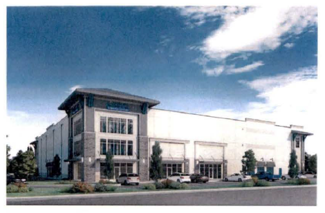
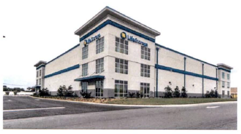
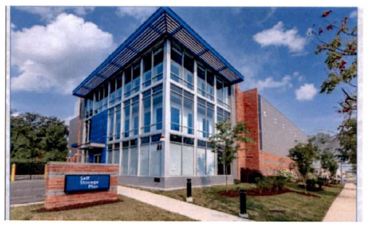
5.
All proposed conditional uses shall be required to submit site plan drawings illustrating structures, facilities, and operations including scale, mass, intensity, elevations and design that demonstrate compatibility with existing and planned land use on adjacent properties; shall incorporate buffer yards, screening, landscape and design specifications compliant with Section 6.4.6; and shall be effectively setback, buffered, and landscaped from the gateway corridors as well as less intensive uses. All land uses must demonstrate compliance all SAP policies, as well as the provisions of the land development regulations. All conditional uses shall be required to demonstrate compliance with all provisions of the SAP and land development regulations including but not limited to the provisions of Section 6.4.6. "Buffer Yards, Screening, Landscaping, and Design Specifications," Section 6.4.7. "SR 17 or CR 544 Corridor Land Use and Architectural Appearance." Section 6.4.8 "Maintenance of Plant Materials and Trees" and Section 6.4.9 "Outdoor Lighting".
C.
Prohibited uses within the SR 17/CR 544 selected area plan commerce park (CP) district. The following land uses are prohibited extraction of raw materials; stockyards or slaughter of animals; scrap metal operations, junk yards, wrecking yards, or salvage yards; manufacture or storage of explosive materials; smelting of ores and heavy metal fabrication; textile mills; leather or allied products manufacturing; rubber, clay, or refractory manufacturing product manufacturing; manufacture of acid, glue, fertilizer, lime or gypsum; fat rendering; campgrounds; flea markets; sexually oriented business such as adult entertainment; outdoor structures used to perform heavy industrial activities such as heating, cooking, vaporizing, pasteurizing, distilling, or similar heavy industrial activities; or any form of residential development, excepting approved accommodation of a security guard, night watchman, or on-site manager, and institutional uses other than essential public services required to support principal uses allowed in the CP district are prohibited.
In addition to the prohibited uses above, any use or structure not specifically or provisionally permitted by this section, or not conforming to the performance standards in Chapter 5 or Chapter 6 of the Land Development Regulations, shall also be considered prohibited.
(Ord. No. 19-1647, § 2, 6-20-2019; Ord. No. 22-2024, § 1, 10-4-2022; Ord. No. 23-2053, § 1(Exh. A), 12-7-2023)
Sec. 6.4.4. - SR 17/CR 544 selected area plan industrial park (IP) district permitted, conditional, and prohibited uses.
The minimum size lot shall be five acres.
A.
Permitted uses within the SR 17/CR 544 Selected Area Plan Industrial Park (IP) District. No distribution activities shall occur on land adjacent to CR 544 and no more than 5 overhead doors, docks, or bays shall be located within the front facade of a building located on a lot or parcel abutting CR 544. Similarly, no distribution activities shall occur within a side yard of a lot or parcel abutting CR 544 unless the activity is setback 200 feet from CR 544 and the vehicles and related activities are screened from public view along the CR 544 corridor. Approved land uses in the IP district shall meet all applicable provisions of this ordinance. Rail dependent operations and other industrial activities with potentially incompatible impacts or activities that are not fully enclosed, shall be located a minimum of 500 feet from the SR 17 and the CR 544 right-of-way. The following uses are permitted in the IP district upon approval of a site plan compliant with applicable laws and ordinances:
1.
Commercial trades, including machine shops; building contract services and supplies, including construction materials, plumbing and electrical services, and related building trades; machine, furniture, and equipment repair; manufacturing of signs and advertising displays.
2.
Facilities for production, assembling, packaging, and/or distribution of precision instruments, and other products that do not involve noxious impacts, including odor, noise, vibrations, emission or smoke and particulate matter.
3.
Manufacture of small electrical or electronic apparatus; coils, tubes, optics, and semiconductors; communication, navigation, guidance, and control equipment; data processing equipment (including computer software); glass edging and silvering equipment; graphics; and art equipment; metering equipment; radio, and television equipment; photographic equipment; radar, infrared, and ultraviolet equipment; optical devices and equipment; filing and labeling equipment; or jewelry and precious metal product.
4.
Research and development, including laboratories, engineering and design of electronics, machinery, equipment, as well as biochemical, chemical, electrical, photographical, medical, metallurgical, pharmaceutical or X-ray research.
5.
Wholesale trade, warehouse, and distribution establishments. Those businesses selling, storing, or distributing mobile homes, or manufactured homes are not allowed.
6.
Apparel manufacturing and commercial and industrial laundries.
7.
Boutique, small scale milk processing and fresh fruit processing but not from concentrate, and may include oils and essence but not processing plants requiring stacks or similar impact producing infrastructure for such activities as pasteurizing, distilling, and cooling tower water vaporizing.
8.
Low to moderate intensive metal, plastics, rubber, and aluminum fabrication, including liquefying molding, extrusion operations; low to moderate intensive rubber, clay and refractory manufacturing; low to moderate intensive petroleum/chemical engineering processing and manufacturing; and low to moderate hydrocarbon processing/recycling activities.
9.
Cold storage and ice processing facilities.
10.
Essential public services supporting commerce and industry, including but not limited to the rail infrastructure; water distribution and wastewater collection systems; law enforcement, security, fire protection, and emergency services infrastructure and service delivery systems.
11.
Facilities for the purpose of indoor vertical farming.
12.
Accessory uses. Any permitted accessory uses must be co-located within the structure accommodating the principal use and shall be customarily incidental and subordinate to such principal use.
a.
Accessory outside operations such as conveyance systems, storage areas, cargo trailer or fleet parking, and cargo handling areas shall not encroach into any front or street yards or buffer area or required side yards buffer area and shall not exceed 50 percent of the area of the site. Where such outside operations abut an active rail line services the facility, the cumulative area of outside operations may cover 60 percent of the site area. Such areas may be buffered by an on-site building that screens the area from adjacent sites or streets. Otherwise, the area must comply with all screening, buffer, landscaping, and setback regulations. All surface areas accommodating outside operations, cargo handling, and parking shall be paved to city standards.
b.
Accessory retail or service uses to a principal permitted use. Such accessory use shall be permitted, provided that such uses shall not occupy more than five percent of the gross floor area of all buildings on any lot or group of contiguous lots in common ownership or control; shall be within a building or enclosure such that there are no external signs or evidence of such uses; and shall have no external access to the uses:
c.
Accessory facilities for the furnishing of meals and sale of refreshments and personal convenience items solely to the employees of the principal industrial or service commercial use and visitors doing business on the premises.
d.
Accessory offices subordinate to the principal industrial or service commercial use on site.
e.
Day care service for commerce and industrial park employees.
f.
Accessory medical or pharmacy services.
g.
Accessory helipads.
B.
Conditional uses within the SR 17/CR 544 selected area plan industrial park (IP) district. The city commission may approve the following uses as a conditional use after a public hearing and subject to appropriate conditions and safeguards. The city commission may approve, deny or add additional conditions for all conditional use requests.
1.
Establishments not allowed as a permitted use which are engaged in the processing, production, assembling, packaging, and/or distribution of food, goods, or products that do not involve noxious impacts, including odor, noise, vibrations, emission of smoke and particulate matter and do not require processing plants with large stacks or similar impact producing infrastructure for such activities as pasteurizing, and vaporizing.
2.
No approved freestanding stack, chamber, storage tank, or similar tall structure shall exceed a height of 70 feet and shall be located at least 500 feet from SR 17 and CR 544. Exceptions to the height threshold shall require a conditional use permit.
3.
Vehicle maintenance facilities.
4.
Warehousing/distribution centers and similar activities related to the sale, storage, and minor repair of automobiles, trucks, recreational vehicles, campers or other large machinery and equipment.
5.
All proposed conditional uses shall be required to submit site plan drawings illustrating structures, facilities, and operations including scale, mass, intensity, elevations and design that demonstrate compatibility with existing and planned land use on adjacent properties; shall incorporate buffer yards, screening, landscape and design specifications compliant with Section 6.4.6; and shall be effectively setback, buffered, and landscaped from the gateway corridors as well as less intensive uses. All land uses must demonstrate compliance all SAP policies, as well as the provisions of the land development regulations. All conditional uses shall be required to demonstrate compliance with all provisions of the SAP and land development regulations, including but not limited to the provisions of Section 6.4.6, "Buffer Yards, Screening, Landscaping, and Design Specifications," Section 6.4.7, "SR 17 or CR 544 Corridor Land Use and Architectural Appearance," Section 6.4.8, "Maintenance of Plant Materials and Trees" and Section 6.4.9, "Outdoor Lighting."
C.
Prohibited uses in the SR 17/CR 544 Selected Area Plan Industrial Park (IP) District. The following land uses are prohibited: extraction of raw materials; stockyards or slaughter of animals; scrap metal operations, junk yards, wrecking yards, or salvage yards; manufacture or storage of explosive materials; smelting of ores and heavy metal fabrication; textile mills; leather or allied products manufacturing; pulp mills; or mineral products manufacturing; manufacture of acid, glue, fertilizer, or lime; fat rendering; outdoor structures used to perform heavy industrial activities such as heating, cooking, non-cooling tower water vaporizing, pasteurizing, or similar heavy industrial activities; flea markets, campgrounds; sexually oriented business such as adult entertainment; or any form of residential development, excepting approved accommodation of a security guard, night watchman, or on-site manager.
In addition to the prohibited uses above, any use or structure not specifically or provisionally permitted by this section, or not conforming to the performance standards in Chapter 5 or Chapter 6 of the Land Development Regulations, shall also be considered prohibited.
(Ord. No. 10-1388, § 2, 12-18-2010; Ord. No. 11-1403, § 10, 8-18-2011; Ord. No. 12-1417, § 7, 3-15-2012; Ord. No. 16-1526, § 2, 3-3-2016; Ord. No. 19-1647, § 2, 6-20-2019; Ord. No. 22-2024, § 1, 10-4-2022; Ord. No. 23-2053, § 1(Exh. A), 12-7-2023)
Sec. 6.4.5. - General standards applicable to the commerce park and industrial park districts.
Proposed development within the CP and IP districts shall meet all the applicable provisions of this section. Medium to heavy impact structures or activities may be required to include a minimum 200-foot setback from detour road and the proposed 30th Street extension right-of-way.
A.
Basic site design standards. Table 1: "Basic site design standards" shall be applied in the commerce park district and in the industrial park district. Any yard abutting a public or private road right-of-way shall be a street frontage yard.
[1] Setbacks from a rail right-of-way shall be compliant with applicable laws and administrative rules. The administrative official may administratively approve adjustments to setbacks from rail rights-of-way to accommodate conveyance systems designed pursuant to best management principles and practices.
B.
Sign regulations. [Also reference "signs," chapter 7, Land Development Regulations.] All sign usage shall comply with the requirements found in the city's Land Development Regulations. Where there is a conflict between the regulations of article 4 and other applicable provisions of the Land Development Code, the more restrictive standard shall apply.
1.
Sign regulations for the commerce park district and industrial park district.
a.
Permitted signs. Freestanding signs, excepting duly approved instructional or directional signs, shall be limited exclusively to monument signs (i.e., low profile ground signs supported by a decoratively designed masonry base or equivalent durable decorative material that complements the material, color, and architectural features of the building(s) advertised. The monument sign should be incorporated into the overall landscape plan and the base of the monument should include ornamental plants that promote a pleasing and harmonious design, may be freestanding pole signs. Monument signs shall have a maximum height of ten feet, and a maximum surface area of 36 square feet per side. Monument signs generally shall be located at the vehicular entrance to the building. Generally, there should be no more than one such monument sign for each site. Wall signs shall be limited to one sign per structure (or business in a multi-business structure), and have a maximum surface area of 100 square feet.
b.
Prohibited signs. Canopy, flashing, moving, portable, pole, projecting pylon, roof, temporary point of purchase or trailer signs, and wind signs shall be prohibited, excepting instructional or directional signs which may be pole signs No signs shall project above the roof cornice line. No on-site billboards or advertising of off-premise goods or services shall be permitted within a commerce park or an industrial park district.
c.
Multi-user signs. A multi-users monument sign may be allowed as a special use where two or more industrial users agree to share a common multi-user identification sign subject to the following conditions:
i.
Maximum height: 15 feet.
ii.
Maximum sign area: 80 square feet.
iii.
Maximum individual user panel size: 20 square feet.
iv.
Maximum of ten panels, plus complex identification.
v.
Signage shall have unified sign design to be approved for materials, lettering, lighting, and colors. Colors and materials shall blend with the building design.
vi.
Installation of sign shall require permission from the property owner of the land where sign is to be located. In addition, a maintenance agreement is required.
d.
Illumination. Illumination shall not create glare or excessive brightness. External lighting fixtures for monument signs should be concealed or screened by landscaping, provided with cut-off shields, and directed so that no glare impacts motorists. High pressure sodium vapor lighting is prohibited.
C.
Landscaping. See chapter 10, article 1, Land Development Regulations.
D.
Parking and access. Chapter 11, articles 1 and 2.
E.
General regulations for nonresidential uses. See chapter 5, article 2.
(Ord. No. 21-1773, § 1(Exh. A), 1-6-2022)
Sec. 6.4.6. - Buffer yards, screening, landscaping, and design specifications.
A.
Buffer yards. The buffer area is intended to minimize any potential adverse impact on the SR 17 and CR 544 gateway corridors; avoid adverse impacts between adjacent land uses of differing types and intensity; and promote land use compatibility. A buffer yard is a portion of a yard on which the city shall require the installation of trees and plant material and may also require decorative walls and/or berms to prevent land use incompatibility. Screening and buffering shall be required to shield unsightly or potentially incompatible features of development from public view and to minimize impacts on adjacent lots, especially where most restrictive and less intensive use of land occurs. Buffer yards shall be required to screen unsightly structures and potentially incompatible uses, including outdoor storage, parking areas, cargo bays, areas frequented by trailer trucks, heavy equipment areas, outdoor distribution activities, conveyance systems, and similar potentially incompatible features of heavy commercial and industrial operations.
The required design specifications of the buffer yard and screening shall vary based on the location of the land use, the nature and potential incompatibility, and spatial relationships between the subject property, adjacent lots and SR 17 and CR 544 gateway corridors. A buffer yard must be a portion of the property under unity of title and may be a portion of the rear, side or front yard setback requirements. Buffer yards are inclusive of required setbacks. The yard depths shown in the buffer yard illustrations are the minimum required unless the city administrative official determines that a lesser standard is in the public interest as discussed in this ordinance as discussed in sub-section (B) below.
B.
Buffer yard specifications and options. The buffer yard requirement is specified in table 2: Front, side, and rear buffer yard requirements by matching the proposed use in the first column with the abutting use shown in the top row. Should a question arise as to the land use classification of a proposed or abutting use or the nature of a potential land use incompatibility, the administrative official shall determine whether a potential land use incompatibility is "moderate," "moderately high," or "high."
Table 2: And the buffer yard legend and illustrations denote the specifications for the buffer yards. The city administrative official shall determine the appropriate buffer yards during site plan review. The buffer yard illustrations include required units of landscaping as measured in 100 linear foot units along the property line. During the site plan review process, the administrative official may adjust the specifications for a site based on sight distance requirements established by the city administrative official in concert with other public agencies as appropriate. The city may require that any buffer yard be installed along the entire length of the property line separating two uses if the city administrative official or renders a finding that the absence of such extended buffer could potentially result in incompatible land uses or activities that may disrupt or otherwise adversely impact the more restrictive or less intense use. Where the city administrative official finds that installation of the buffer along certain segment(s) of the property line is: 1) impractical; 2) unreasonable; and 3) will not serve the public interest, the city administrative official may modify the buffer requirement. The intent is to ensure that adjacent nonresidential uses within the commerce park district or industrial park district having a different character and intensity are separated by a buffer yard that effectively protects the more restrictive (i.e., more intensive) abutting use, such as traffic, noise, odor, unsightly appearance, or other adverse impacts.
C.
Use of existing vegetation in buffer yard areas. Existing vegetation within a required buffer yard may be retained and used to defray the require number of new tree or plant installations to the degree practical and feasible. However, no credit shall be extended for citrus trees. The use of existing vegetation shall be approved only if it meets or exceeds the specifications of required plantings. Site plans shall show location and extent of existing vegetation within buffer yard areas.
D.
Design of buffer to achieve opaque screen. When landscaping is required to conceal an outdoor storage area, high intensity operations area, cargo bays, refuse storage, or other potentially disruptive, incompatible, or otherwise noxious use, the city administrative official may require that only conifer (evergreen) plants, suitable for local conditions with or without a decorative masonry wall be installed to achieve an opaque screen. Deciduous trees may be planted along with the evergreens to enhance the height of the screen. Lower story deciduous shrubs may be used in front of evergreen screens as part of the required number of plants. When structures are used, the materials shall be durable and suitable for screening.
E.
Berms, walls, tree caliper, and plant size. Berms shall be applied in the design of landscaped gateway setbacks as stated below. Walls with plants and trees shall generally be used to screen outside storage areas, cargo bays, loading, unloading, and related outdoor distribution operations. Materials, products, or equipment outside of a fully enclosed building shall be concealed from public view from SR 17 or CR 544 and from adjacent properties. However, such screening may not be required merely to screen one outside operation from a similar use or activity on an adjacent site unless the city administrative official deems that a potential for incompatibility exists. The city administrative official may require a wall in combination with required screening based on the location, intensity, and nature of the outdoor use or activity, and line of sight from a gateway or adjacent site. The minimum tree and shrub specifications are described in the buffer yard illustrations.
1.
Berms. A berm system with trees and shrubbery shall be required along the SR 17 and CR 544 gateway setback. All berms shall be landscaped as herein required. The city administrative official may require a berm system as part of a buffer and screening design if the added height is necessary to improve upon the screening required by a proposed use or activity. Berms generally shall have a four to one slope and shall not exceed a three to one slope. The buffer yard width and site conditions will determine the proper slope ratio to be used for berms. Generally, all berms shall have compacted and stabilized dirt, shall be landscaped with trees and shrubs, have no more than ten percent mulch and all other areas shall be sodded.
2.
Wall specifications. Where walls are used in design of a buffer or other project feature, the walls must be made of decorative textured masonry material, including poured concrete, cut block, concrete block covered with stucco, brick, or equivalent durable decorative material. The materials and design elements shall be consistent or detour road shall be constructed with a decorative, opaque, high density perforated metal screening or equivalent durable material and shall be painted to match or complement the wall of the building. Site entries requiring gates shall be offset from direct view to loading areas where possible to minimize extent of screening, and avoid direct view to loading areas when gates are open. Where the applicant proposes chain link fences for security or safety purposes and such fence is potentially visible from a public right-of-way or residential zone, the chain link fence shall be screened with a durable and decorative feature and/or covered with a durable and decorative green vinyl or equivalent material. All plants must be sized and spaced to obscure the chain link fence at the time of planting. Chain link fences with wood, plastic, or metal strips are expressly prohibited. No chain link fence shall be placed within the required 25 feet arterial road setback.
a.
Height of walls. Street side walls shall adequately screen views to the top of loading bays and parked vehicles and/or trailers. The height of walls should not exceed 12 feet from the highest finished grade. The area of walls shall be landscaped with shrubs and trees reaching a mature height that exceed the height of the wall.
b.
Special design considerations. Long expanses of uninterrupted walls shall be avoided. No wall shall contain a continuous, uninterrupted wall plane greater than 40 feet. Landscaping, including trees and shrubs as a minimum, shall be provided on the outside wall face providing visual relief. Design features shall include: raised planters, openings, material change, staggered sections, pilasters or posts, or other equivalent functioning features. Wall openings shall be provided to connect walkways as needed to avoid circuitous routes for pedestrians. The pedestrian gates should be enhanced by pilasters, trellises, special landscaping, or other decorative features. Landscape berms should be provided to minimize the height impact of the screen walls.
F.
Maintenance. The maintenance of required buffer yards shall be the responsibility of the property owner. All such areas shall be properly maintained on a continued basis so as to ensure perpetual buffering and screening. Plant materials which exhibit evidence of insects or other pests, disease and/or damage shall be appropriately treated, and dead plants promptly removed and replaced with correct sized plants. Debris and litter shall be cleaned; and berms and walls shall be maintained at all times.
G.
Use of buffer yards. A buffer yard shall be a passive green open space and may be interrupted by access driveways. All other uses are prohibited, including off-street parking and accessory uses.
H.
Sight clearance. Buffer yards may not obscure a clear line of sight for vehicular traffic.
I.
Storage and screening of approved outdoor storage and fleet vehicles. Unsightly structures or activities such as dumpsters or other waste storage areas, loading docks, storage tanks, other or like equipment shall be stored at the side or rear of the building and shall be screened from public view. Screening materials shall be constructed and designed in such a manner so that they equal a height equal to that of the materials or equipment being stored but in no event less than six feet in height. The screening, to the maximum practical extent, shall shield said material and equipment from both public view. Reference buffer and landscaping requirement illustrated in table 2: "Front, side, and rear buffer yard requirements" and in side and rear buffer yard illustrations, especially illustrations three through five. Storage of fleet vehicles, service vehicles and other such vehicles shall not be stored in a parking lot fronting SR 17 or CR 544. Such vehicles must be stored within a rear yard service area or within a side yard that is appropriately screened by a landscaped buffer yard meeting the specifications required for the principle use.
J.
Compatible land use; compatibility defined. In land use planning, "compatibility" means the extent to which a use(s) or development is capable of existing in harmony with other uses situated in its immediate vicinity. The State of Florida defines "compatibility" as "a condition in which land uses or conditions can coexist in relative proximity to each other in a stable fashion over time such that no use or condition is unduly negatively impacted directly or indirectly by another use or condition." In this ordinance potentially incompatible land uses are regulated and required to be screened by buffer yards and landscaping which may consist of berms, walls, trees, and plant material. The landscaping specifications are based on the degree of potential incompatibility: "moderate," "moderately high," and "high." The relative degree of incompatibility will be based on the zoning district, size of site; the type and location of the use; structure, or activity; mass, dimensions and height; the scale, extent and intensity of the use or activity as measured by potential noise, vibration, odor, emissions of particulate matter, or other potentially adverse noxious environmental impacts; traffic generation, hours of operation, setbacks from site perimeter and pre-existing screening by buildings, trees, or vegetation. The intent of the city is to ensure functional and attractive development.
K.
Screening and buffer yards. Table 2: "Front, side, and rear buffer yard requirements" lists required screening and buffer specifications for front, side and rear yards required along SR 17 and CR 544 corridors and to separate potentially incompatible land uses, structures, or operations of dissimilar character and/or intensity.
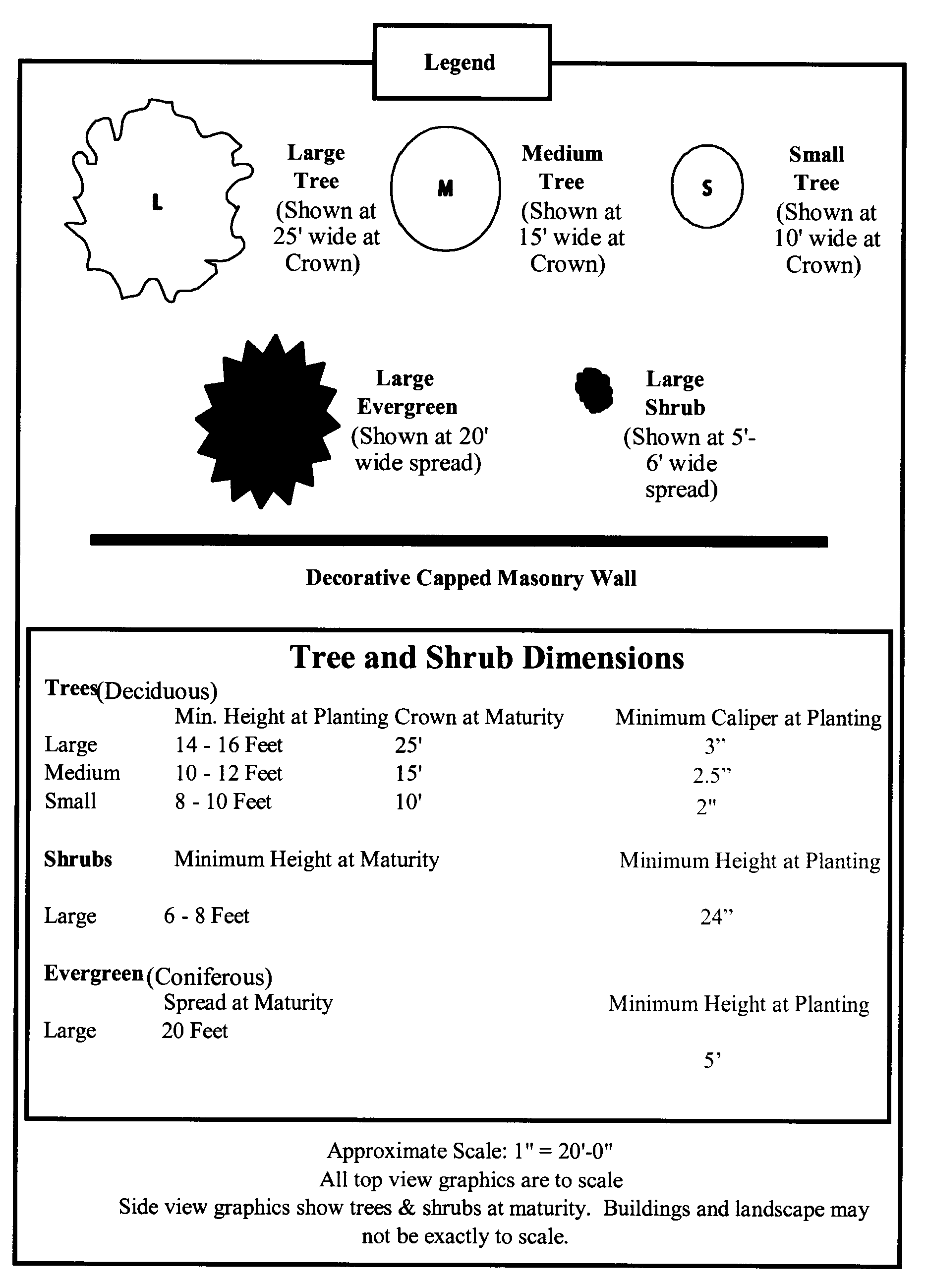
Front Buffer Yard 1: Front Yards Facing SR 17 or CR 544 with Less than 6 Rows of Parking
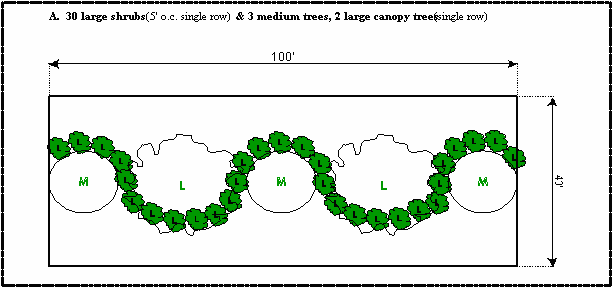
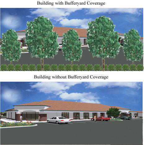
Front Buffer Yard 2:
Front Yards Facing SR 17 or CR 544 with 6 or More Rows of Parking
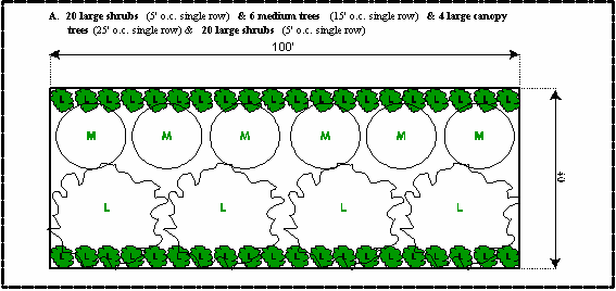
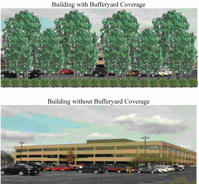
Side and Rear Buffer Yard 3:
Potentially Moderately Incompatible
Land Uses, Unsightly Structures, Parking, Storage, or Operation Areas
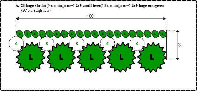
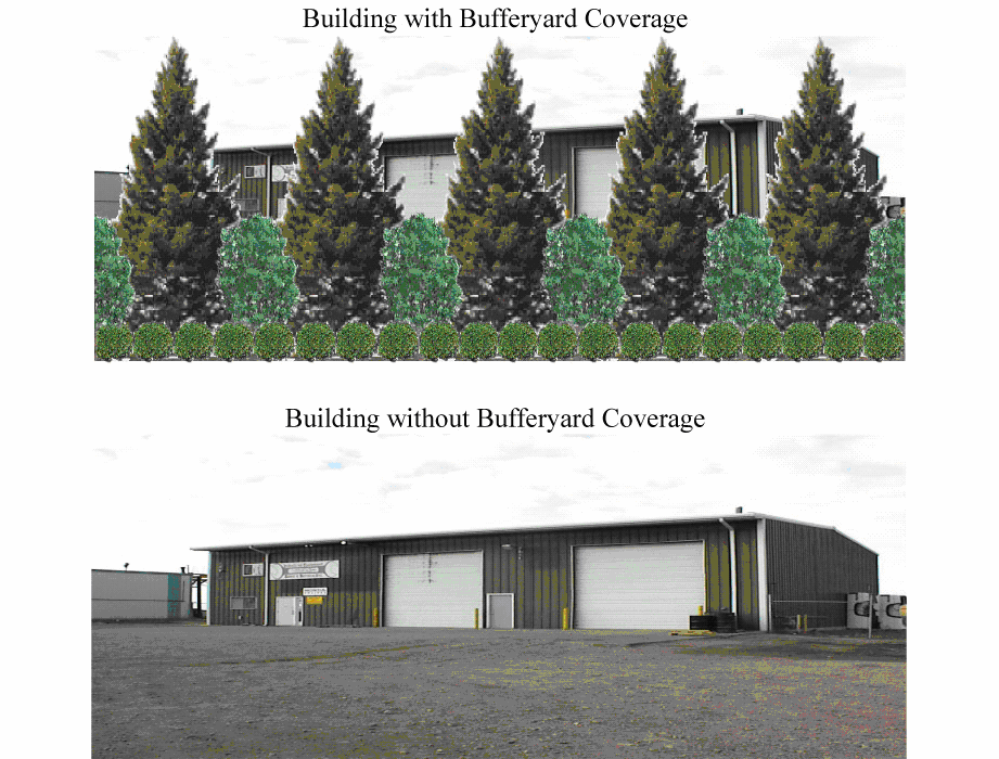
Side and Rear Buffer Yard 4:
Potentially Moderately High Incompatible
Land Uses, Unsightly Structures, Parking, Storage, or Operation Areas
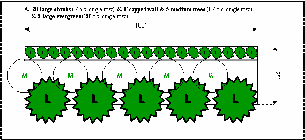
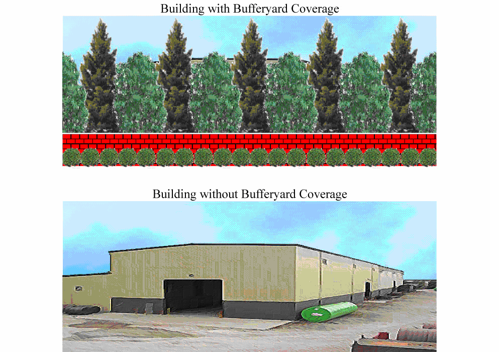
Side and Rear Buffer Yard 5:
Potentially Highly Incompatible Land Uses, Unsightly Structures, Parking, Storage,
or Operation Areas
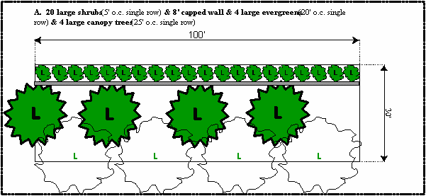
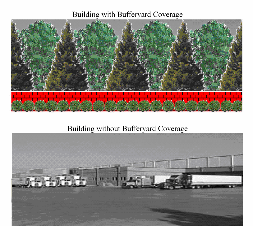
(Ord. No. 13-1453, § 3, 7-18-2013)
Sec. 6.4.7. - SR 17 or CR 544 corridor land use and architectural appearance.
A.
Front facade. Any facade of any building that faces SR 17 or CR 544 or a frontage road running parallel to these facilities shall be deemed to be a front facade. The front facade and all facades within 40 feet of the front facade must be design to achieve an "office-front" appearance and have a decorative front pedestrian entryway. The front facade of any such building shall be faced with one of, or a combination of, the following"
• Face brick, stone, glass or similar material;
• Architecturally treated concrete;
• Stucco or other decorative coating applied to a code compliant building material in a manner as to create a harmonious design with other exterior materials.
• Architecturally designed metal fascia, soffit, and roof components can comprise a maximum of 25 percent of the front facade.
Front facades adjacent to SR 17 and CR 544 shall avoid large blank areas between massing breaks, have a recognizable base and top, and include texture, revealed pilaster, change in plane (two feet minimum; four feet recommended), vertical variation in roof line, windows, lattice, accent trees, or equivalent. The "base" should visually relate to the proportion and scale of the building. Techniques for establishing a base include (but are not limited to) richly textured materials such as tile or masonry treatments; darker colored materials, mullions, panels, reveals, and/or enriched landscaping. The "top" should take advantage of the visual prominence of the building's silhouette. Techniques for clearly expressing a top may include (but are not limited to) cornice treatments, roof overhangs with brackets, richly textured materials such as tile, masonry, or fluted concrete), and/or differently colored materials. Colored "stripes" are not acceptable as the only treatment. Texture, reveals, and color may be appropriate in some applications.
Said facing shall extend across the full front of the building and also extend a distance of not less than 40 feet on each side of the building adjacent to the front of the building. That portion of any building facing detour road shall also be deemed to be a front facade and shall be finished in an attractive manner in keeping with the general standard for industrial buildings but need not be finished in a as a front facade facing SR 17 or CR 544. It is the intent of this provision that all structures in the commerce park and industrial park be designed and constructed in such a manner as to provide an aesthetically pleasing and harmonious development. All building facades should be made attractive through the use of careful detailing, especially at the base of buildings, along cornices, eaves, parapets, or ridge tops, and around entries and windows. Appearance may also be enhanced through the correct used of materials, expansion joints, and reveals. Window frames should appear substantial and should not be flush with the exterior finish. Glazing should be inset at least two inches from the front face of the exterior finish. Building shall be kept in good repair and appearance at all times and shall be compliant with all federal, state, and local building codes and other applicable laws. The following provisions shall be applicable to all sites located adjacent to SR 17 or CR 544 or a frontage road running parallel to these facilities. All landscaping shall be located outside of the public right-of-way.
B.
Side Faces on IP Sites Abutting CR 544. No overhead doors, loading docks or cargo bays shall be located within a side facade of a building located on a site CR 544 unless the same are located at least 200 feet south of CR 544 and shall be screened from public view along CR 544. Cargo bays and docks, that are located along such a side facade shall be inset in below grade wells and designed so that the cargo trucks and trailers park parallel to the facade.
C.
Roof top utilities. Roof-top mechanical equipment shall be integrated into the overall mass of the building and shall be located and screened from public view by an appropriate barrier. At a minimum, roof mounted equipment shall be screened through the use of parapets, screen walls, equipment wells, mechanical room enclosures and similar design features. Screening devices other than parapet walls shall be designed as an integral part of the building mass. Picket fencing, chain-link fencing and metal boxes shall be avoided. The top of screens shall be at least as tall as the top of the equipment to be screened and shall provide additional height where larger equipment units are likely to be installed in the future. Cross section drawings should be prepared to illustrate the method in which the equipment will be screened from view of SR 17 and CR 544. Flues, vents, and pipes on the roof should be painted a color that matches their background or roof material in order to reduce their visibility.
D.
Front and side yards; drainage. All front and side yards not used structures, parking, sidewalks, access roads, or approved land use activity shall be graded with adequate drainage provided and shall be sodded and maintained in grass and landscaped areas with trees and shrubs. All drainage retention/detention facilities shall be designed as a project amenity and the design shall be approved by the administrative official. No drainage retention shall be located between the street and the front building facade unless the specific location and design is approved by the administrative official and must be predicted on a demonstrated need and lack of effective alternatives sites. The overall amount of landscaping required for each site will be based on the landscape plans approved by the city pursuant to the landscape ordinance within the Land Development Code. However, in no case shall approval of a plan be granted which does not contain a least the minimum standards as specified in these criteria.
E.
Front facade foundation landscaping. A minimum of at least one three- to five-gallon foundation shrub for every three linear feet of building front facade and one specimen tree of at least two inch caliper per 35 linear feet of building facade shall be placed along the foundation of any front facade facing SR 17 or CR 544. The shrubs shall be a minimum of 30 inches tall at the time of planting. This landscaping requirement does not apply to portions of the building facade that provide access for pedestrians. The front facade landscaped area shall be at least five feet wide. Ground cover plants must fully cover the remainder of the five-foot landscaped area along the foundation.
F.
Separation of customer parking and service area parking. Areas for customer parking shall be separated from any areas designated for commercial or industrial cargo bay and service areas, loading and unloading, storage areas, or other outside business related operations. Customer parking shall be located on a paved parking surface compliant with city design standards and the customer parking lot shall be located within a front or side yard. No parking shall occur on a frontage road or within grassed open space areas. Customer parking lots may be located within a rear yard if there is a clear separation from any outside business service areas as herein described. Concrete walkways shall be provided that link front, side, or rear yard patron parking areas to building entryways.
G.
Perimeter landscaping for customer parking lots. Parking lots as well as related internal and perimeter landscaping shall comply with applicable Land Development Code. No parking shall be allowed to encroach into a required landscaped setback or buffer areas. A landscaped divider with concrete curbing shall be constructed to separate every 15 contiguous parking stalls. The landscape divider shall have a minimum dimension of ten feet and shall comprise a minimum total 100 square feet of landscaped area. One deciduous tree shall be required for each such divider.
H.
Building entrances for customers. Entryways on building facades visible from SR 17 or CR 544 shall be connected via pedestrian walkways with customer parking areas. The front facades shall include a major entry feature and fenestration over at least 25 percent of the facade's surface. A monolithic appearance shall be avoided. Entryways shall incorporate special materials, color, detailing, or equivalent architectural treatment at major entries. Primary building entries shall be highlighted through the massing of the building. Greater height can be used to highlight and accentuate entries in the form of corner tower elements, tall voids, or a central mass meeting an entry plaza. Conversely, smaller building masses can also communicate the location of entries. Landscaping at major building entryways shall be provider along with a sidewalk connecting to the front parking area.
Sec. 6.4.8. - Maintenance of plant materials and trees.
All plant material shall meet Florida Nursery No. 1 or better standards. All landscaped areas shall be appropriately irrigated and plants, grass, and trees shall be orderly and well maintained. Any areas of disturbed earth not in landscaped areas shall be sodded to reduce erosion and dust particles. Plant materials which exhibit evidence of insect pests, disease, and/or damage shall be removed within 60 days following notification by the city and shall be replaced within the next appropriate planting season or within one year, whichever occurs first.
Sec. 6.4.9. - Outdoor lighting.
A.
Pole lighting. Pole height shall not exceed 30 feet measured at the street frontage or measured from finished grade to top of pole or light source/luminaire, whichever is highest. Pole mounted lighting shall be restricted to horizontal lamps with flat lenses. Wattage should generally be 250 watts but shall not exceed 400 watts. The design components shall effectively reduce glare to an acceptable IES standard.
B.
Illumination. The footcandle level adjacent to nonresidential development shall be consistent with IES recommended standards and generally should not exceed one footcandle level. The footcandle level at the front property line of SR 17 or CR 544 shall not exceed 0.4 footcandles. The source of the illumination shall not be visible from off sight.
C.
House shields. House shields generally shall be required on all perimeter lighting to avoid spill over of light and glare onto adjacent properties that have a less intense use.
D.
Flood lighting. No flood lighting shall be directed into a parking lot and no flood lighting shall be directed away from a building (i.e., no flood light shall be building mounted and directed toward a parking area).
E.
Location and design. Lights used to illuminate parking and or building shall be arranged in a manner that does not create a hazard or nuisance to traffic.
Sec. 6.4.10. - Site plan procedures.
A.
Special conditions of approval. In order to ensure compliance with section 6.4.6(J) "compatible land use," where necessary to ensure compatibility of buildings and uses with each other and with off-site properties, the administrative official or the city commission, on appeal, may require significant revisions to site plans. For example, if a potential incompatibility of a land use, structure, or activity cannot be adequately addressed by the required buffers and screening, the location, size, scale, intensity, or other attributes of the use, structure, or activity shall be modified to comply with the provisions of the Land Development Code.
B.
Effective period of site plan approval. Approval of a site plan shall be effective for a period of 12 months.
C.
Conformance to site plan approval and minor amendments thereto. No permits shall be issued by the city, and no development shall commence unless in conformance with the approved site plan, unless a change or deviation is approved under provisions of the Land Development Regulations. The administrative official may approve minor changes and deviations from the approved site plan which are in compliance with the provisions and intent of this ordinance, and which do not depart from the principal concept of the approved site plan. Examples would be a minor shift of a parking lot location. All other requested changes and deviations shall be referred to the city commission.
D.
Site and building design waivers. In order to ensure that a certain degree of design flexibility may be applied to the site, the administrative official may grant waivers to the required site and building design standards where an alternative and equivalent design proposal are proposed that meet the intent of the district regulations. Examples of these waivers may include:
1.
Permission to allow front yard loaded lading docks when a taller berm with landscaping will provide a screened view of the loading docks, overhead doors and truck storage.
2.
Modifications to required landscaping standards where alternative and equal landscaping solutions are acceptable.
3.
Waivers to required building design standards where equal design alternatives are proposed that meet the intent of the LDRs.
(Ord. No. 10-1388, § 2, 12-18-2010)
Sec. 6.5.1. - Purpose and intent.
The intent of article 6.5 is to implement the us 27 north ridge selected area plan (SAP). This selected area (SAP) was adopted in the Polk County Comprehensive Plan to recognize the anticipated high level of urbanization during the next twenty years along the US 27 corridor between Haines City and Interstate 4. The districts and performance standards that follow implement the public/private initiatives outlined in the plan. In order to achieve an efficient and highly desirable urban growth pattern, a balance of residential and nonresidential uses is required, as well as a range of housing opportunities and short trips between housing, employment, and shopping including access management. The approach utilized in the SAP districts include the creation of traditional neighborhood villages.
Sec. 6.5.2. - General site planning principles.
Proposed development within the us 27 North Ridge SAP shall be compliant with the following planning principles:
1.
Manage urban growth pattern. An efficient and highly desirable urban growth pattern requires a balance of residential and nonresidential uses, a range of housing opportunities, and short trips between housing, employment, and shopping.
2.
Promote connectivity. A more efficient US 27 urban corridor growth pattern shall be attained through the interconnection of urban nodes, tourist activities, and medical and commercial centers.
3.
Reinforce economic sustainability. Development within the planned medical center and complimentary office/institutional sub-centers as well as development within the planned mixed use employment center shall reinforce economic sustainability and be responsive to needs of residents and the business community. US 27 corridor development. Such development shall:
a.
Compliment the downtown area and should not cause displacement of major activities and traditional function of the central business district;
b.
Reinforce city economic growth objectives and new job creation;
c.
Promote high quality development and higher tax ratable along the US 27 corridor;
d.
Improve the overall land values of the area.
4.
Advance development of the regional medical and professional office center. The Mid-Florida Regional Hospital will continue to serve as a catalyst for development of a broad mix of medical services and compatible office/institutional enterprise generally located between Florida Development Road south to SR 547. Improvements to the I-4/US 27 interchange, widening of US 27 highway, and construction of the parallel collectors east and west of US 27 will enhance access to this target area. Land use between the US 27 corridor and the proposed collectors shall be compliant with the SAP land use, intensity, and design policies, especially strategically located vertically mixed use traditional neighborhood development.
5.
Accommodate mixed use community and neighborhood activity centers. The roadway improvements identified in paragraph "4" above will also be a catalyst for the development of a planned mixed used employment center together with neighborhood and community activity centers located between SR 547 south to Patterson Road. The 50 + acre Community Activity Center(CAC-NR) located NW and SW of the US 27/SR 547 intersection contains 30 unincorporated acres that should be annexed to provide for a well planned and coordinated mixed use community activity center with high ratable commercial activities on sites with frontage and high visibility to US 27. Neighborhood Activity Centers (NAC) are planned west and north of Tower Lake, respectively.
6.
Protect the Green Swamp. Conservation easements shall be required to ensure protection of wetlands and endangered or threatened habitats within the Green Swamp. The developer shall design and locate proposed improvements to minimize the removal of native vegetative communities. However, it is not the intent of this provision to preclude the reasonable use of a lot or parcel of land consistent with the comprehensive plan and Land Development Code. Where disturbance of a wetland or wetlands is unavoidable, mitigation shall be completed in accordance with the guidelines of the appropriate regulatory agencies. However, whenever possible, the receiving zones shall be located within the Haines City corporate limits. Receiving zones will be identified to assist these agencies in providing options for off-site mitigation in order to protect, enhance, or restore local environmentally sensitive systems. Wetland delineation as well as requisite development modifications, mitigation, and building setbacks shall be as determined by the water management district having jurisdiction. Wider setbacks may be required by the city depending on the intensity of the development proposed adjacent to the area. [Source: PC Comp Plan Appendix 2.131-U-1 V-2 "North Ridge Selected Area Plan," and PC Comprehensive Plan.]
7.
Promote interconnectivity of roadways and pedestrian/bikeway infrastructure. All site plans shall be compliant with policies promoting interconnectivity. Pedestrian and bikeway facilities shall provide safe routes linking residents to park and recreation areas, schools, and commercial facilities and provide such facilities along collector and arterial roads. All development shall provide for integration of pedestrian access ways, internal circulation improvements, and interconnection of pedestrian/bikeway connections, street system components, frontage roads, and cross-easements.
8.
Access management and internal circulation. All types of activity centers shall have frontage on, or direct access to an arterial roadway, or a frontage road or service drive which directly serves as arterial roadway. Access to such development shall include a safe and well designed internal road system, frontage roads, cross-access easements, acceleration and deceleration lanes and/or shared ingress/egress access easements that accommodate the projected trip generating characteristics of the site. Curb cuts shall be managed consistent with applicable law and the use of cross easements and shared ingress/egress facilities shall be required wherever practical. Interior traffic-circulation patterns shall facilitate the safe movement of vehicular, bicycle, and pedestrian traffic.
9.
Buffering, landscaping, screening and aesthetics. All development shall include buffering that meets the development standards set forth in the Land Development Regulations and the landscaping, screening, and buffering design shall effectively mitigate potential nuisance factors that may otherwise adversely impact adjacent land uses. Lighting shall be appropriately shielded from adjacent parcels, especially residential properties and roadways. Similarly, parking lots, loading areas, dumpsters, utilities and air conditioning units, and signage, shall be designed to include appropriate landscaping, screening, shielding, and/or buffering, and all development and redevelopment shall have underground utilities.
10.
Activities to occur within enclosed buildings/outdoor storage. All land uses and related operations shall be conducted within enclosed structures with the exception of loading and unloading of transport and distribution vehicles. Outdoor storage shall be effectively screened from off site view.
11.
Promote pedestrian oriented environments, mass transit, and vertically mixed use development. Vertically mixed use development on sites designated NAC-NR, CAC-NR, and PIC-NR shall create pedestrian environments and foster mass transit by incorporating traditional neighborhood design principles (i.e., also referred to as neo-traditional and new urbanism), including associated architectural themes, design techniques, and amenities. Where mass transit stops are planned, all new development and redevelopment on sites of five acres or more shall be designed to accommodate a mass transit stop on-site that provides safe and convenient access and egress for transit vehicles and appropriate shelter for mass transit patrons. [Source: PC Comp Plan FLUE, Policy 2.125-H (2), section "B" above requires compliance with this Co. CP Policy.]
12.
Promote land use compatibility and visual quality. All development shall generate land use compatibility by advancing a smooth transition in land use and intensity of development, and by incorporating high quality of landscaping, signage, and design features, especially building facade and fenestration. Building facades shall have facade landscaping and shall be made attractive through the use of careful detailing, especially at the base of buildings, along cornices, eaves, parapets, or ridge tops, and around entries and windows.
Sec. 6.5.3. - Zoning districts and effect of SAP.
The following table 6.5.3 denotes the respective zoning districts that will implement adopted the city's comprehensive plan future land use designations within the US 27 North Ridge SAP. Where the US 27 North Ridge regulations contained in this article are in conflict with zoning district regulations within other chapters of the Land Development Code, the regulations within this article shall control.
(Ord. No. 07-1309, 11-1-2007)
Sec. 6.5.4(A). - Permitted and conditional land uses by zoning district.
The following table 6.5.4 denotes the respective permitted and conditional uses that may be approved within each zoning district:
(Ord. No. 07-1309, 11-1-2007; Ord. No. 09-1346, § 13, 8-6-2009; Ord. No. 11-1403, § 11, 8-18-2011; Ord. No. 12-1417, § 8, 3-15-2012; Ord. No. 12-1424, § 3, 7-5-2012; Ord. No. 17-1584, § 3, 11-16-2017; Ord. No. 18-1594, § 3, 3-1-2018; Ord. No. 23-2041, § 1(Exh. A), 5-18-2023; Ord. No. 24-2068, § 1(Exh. A), 4-4-2024)
Sec. 6.5.4(B). - Conditional use criteria.
Within the PIC-NR future land use map designation, the base intensity (e.g., expressed as a floor area ratio) may be exceeded if duly approved as a conditional use. The city shall apply the following criteria to determine whether a proposed conditional use is suitable for the site and is appropriately designed to avoid potential land use incompatibility, including potential adverse impacts. The design criteria shall be applied to achieve smooth transition in land use, including density, intensity, appearance, size, height, mass, and design amenities. The intent is to ensure that conditional uses shall be permitted only on specific sites where the proposed use can be adequately accommodated without generating adverse impacts on land uses within the immediate vicinity. The specific site must have sufficient land area to accommodate the proposed use, including its scale, mass, density and/or intensity, as well as requisite project amenities, and infrastructure. Land use compatibility also shall be measured by the application of best management principles and practices of site design, including such attributes as screening and buffering, lot layout and orientation of structures; architectural feature such as facade elevations, facade landscaping, fenestration, building articulation, pedestrian access and circulation; internal vehicular circulation together with access and egress to the site, and off-street parking. The site plans shall apply mitigative measures such as additional landscaping, buffering, and setbacks deemed necessary by the city to avoid land use incompatibility as well as adverse environmental and nuisance impacts. A proposed conditional use shall only be approved if a site plan demonstrates compliance with all applicable Land Development Regulations, especially the criteria established in section 6.5.14 of the Land Development Code. If adequate site planning including buffers and setbacks cannot effectively mitigate potential adverse impacts, the city can require that the site plan be significantly modified, including a reduction in the square footage of the use, height, mass or other site plan features. If such site plan revision cannot mitigate potential impacts, the city has the power to deny approval of the conditional use.
Sec. 6.5.4(C). - Transitional uses permitted by annexation agreement.
Transitional uses may be allowed as conditional land uses by zoning district. These uses are established by annexation agreement and are intended to recognize and provide for a smooth transition from existing, permitted uses by Polk County prior to annexation to Haines City permitted uses after annexation. The conditional use criteria may include:
1.
Provided a listing of uses in transition.
2.
Establish conditions related to the operation of uses.
3.
Timing related to the transition period.
4.
Other appropriate and mutually agreeable use criteria.
(Ord. No. 12-1424, § 3, 7-5-2012)
Sec. 6.5.4(D). - Agricultural uses.
Agricultural uses may be allowed as a conditional use in the R-1A-NR and R-3-NR zoning districts. The intent of this provision is to allow for a viable use of property by limited agricultural activities, while ensuring that adjacent uses are not adversely impacted by said activity. Allowable agricultural uses include the following:
1.
Citrus (but not packing houses or similar activities).
2.
Horticulture.
3.
Forestry (but not lumberyards, processing areas, or similar facilities).
4.
Grazing, pasture and growing of hay.
5.
Limited housing of animals, provided no building for the housing of animals shall be located within 200 feet of any residentially zoned property. Such limitations shall be defined through the conditional use process.
6.
A minimum of five acres is required.
(Ord. No. 12-1424, § 3, 7-5-2012)
Sec. 6.5.5(A). - Low density residential (R-1A) and medium density residential (R-3).
The following table 1.1.3(3) denotes standards for density as well as size and dimension standards for low and medium density residential development. Detached and attached single family dwelling units are prohibited within all zoning districts within the US 27 North Ridge SAP, excepting R-1A and R-3 zoning districts.
Sec. 6.5.5(A)(1). - Child care center standards.
Child care centers shall be allowed as a permitted use within NAC-NR and CAC-NR and as a conditional use within R1-A-NR, R-3-NR and PIC-NR and shall be subject to the standards pursuant to Florida Statutes:
a.
Must have a minimum of 20 square feet of usable indoor floor space for each child.
b.
Must have a minimum of 45 square feet of usable outdoor play area for each child. Outdoor play area shall be calculated at the rate of 45 feet per child in any group using the play area at one time. A minimum play area shall be provided for one half of the licensed capacity. This standard applies as long as the child care facility remains licensed at the site occupied on October 1, 1992 and shall not be affected by any change in the ownership of the site.
c.
A child care facility that does not hold a valid license on October 1, 1992, and seeks regulatory approval to operate as a child care facility must have a minimum of 35 square feet of usable floor space for each child and a minimum of 45 square feet of usable outdoor play area for each child.
d.
The minimum standard for outdoor play area does not apply in calculating square footage for children under one year of age. However, appropriate outdoor infant equipment shall be substituted for outdoor play space. The center shall provide facilities and equipment conducive to the physical activities appropriate for the age and physical development of the child.
e.
No portion of the fenced play area shall be closer than five feet to any residential lot line not closer than 40 feet to any public street.
f.
A five-foot high solid masonry wall, or vegetative screening which furnishes equal protection against noise, shall be provided between fenced play areas and residential lot lines in such locations as may be directed by the planning commission.
g.
All outdoor play activities shall be conducted within the fenced play area, and no outdoor play activities shall be conducted before 8:00 a.m. or after 8:00 p.m.
h.
All facilities, operation and maintenance shall meet city, county and state requirements of the operation of child care centers.
i.
Where a property owner has three or less contiguous lots platted prior to September 9, 1971, each of which is a minimum of 50 feet in width and 5,000 square feet in area in which a dwelling occupies one of these lots in case of two or on the center lot in cases of three, the owner may build upon, sell or convey in some legal manner those remaining 50-foot lots for use for one family detached dwelling. Unless otherwise stated, all other requirements within this district shall apply to the lot and land use.
(Ord. No. 07-1309, 11-1-2007)
Sec. 6.5.5(A)(2). - Performing arts school/ training center standards.
A performing arts school/training center shall be allowed as a conditional use within RI-A-NR and R-3-NR districts and shall be subject to the following standards:
a.
Must have a minimum of five acres.
b.
A ten foot buffer with a six-foot high solid masonry wall as per standards in chapter 13, section 13.3.8 of the Land Development Regulations and landscape buffer screening shall be provided between developed areas and residential lot lines.
c.
All outdoor activities shall be conducted within a confined activity area, and no outdoor activities shall be conducted before 8:00 a.m. or after 9:00 p.m.
d.
All activities shall be concluded by 10:00 p.m. nightly.
e.
All outdoor lighting shall be directed into the subject property and there shall be no direct lighting into the adjoining properties.
f.
Any outdoor, amplified music shall be held to a minimum and not be so loud as to be a nuisance to the adjoining properties.
g.
All facilities, operation and maintenance shall meet applicable city, county and state requirements of the operation.
(Ord. No. 24-2068, § 1(Exh. A), 4-4-2024)
(Ord. No. 07-1309, 11-1-2007)
Sec. 6.5.5(B). - Nonresidential and mixed use density and intensity by district.
The following table 6.5.5.1(b) denotes the respective density and intensity that may be approved within each nonresidential and mixed use zoning district and table 6.5.5.2 denotes the required setbacks by district.
1.
Densities and intensities in the Green Swamp upland transition area located east of the core area of critical state concern (GSACSC). The Green Swamp core area is defined in section 6.5.7.1.
2.
Mixed use buildings are allowed to a maximum of three stories with up to two stories of residential above the nonresidential use. FAR applies to nonresidential use only.
3.
Commercial development within vertically mixed use traditional neighborhood development shall not exceed as ISR of 60 percent unless the lots are part of a site plan which maintains as overall ISR of 50 percent. [PC Comp Plan Appendix 2.132 "Critical Area RMP," Policy 2.132-B-9].
4.
All proposed conditional uses shall be required to submit site plan drawings illustrating structures, facilities, and operations including scale, mass, intensity, elevations and other design measures necessary to demonstrate compliance with section 6.5.4(B). Conditional use criteria.
(Ord. No. 07-1309, 11-1-2007; Ord. No. 21-1724, § 1(Exh. A), 2-18-2021)
Sec. 6.5.5(C). - Required setbacks.
The following table identifies required setback requirements from roadways by roadway classification.
1.
Measurements of the minimum setback distance shall be made from the property line or the center line of the right-of-way to the building line, whichever provides for the greatest setback distance from the roadway.
2.
The minimum setback distance from front, exterior side, and exterior rear lot lines for all districts shall be, 25 feet, the same distance as the minimum setback from the right-of-way line of a public local road in the district where the principal structure is located.
(Ord. No. 07-1309, 11-1-2007)
Sec. 6.5.6. - SAP supplemental regulations for specific sap land use designations.
In addition to the city's comprehensive plan, the following supplemental regulations shall be applied to achieve the goals and objectives of the US 27/North Ridge SAP. The Land Development Code provides implementing regulations that are also applicable. [Source: PC Comp Plan Appendix 2.131-Q4 "North Ridge Selected Area Plan," Policy 2.131-Q4 and PC Comprehensive Plan, Policy 2.110.]
Sec. 6.5.6.1. - Neighborhood activity center (NAC-NR).
The following supplemental regulations are applicable to development on lands zoned NAC within the us 27 north ridge SAP: [Source: Pc Comp Plan Appendix 2.131-Q1 "North Ridge Selected Area Plan," policy 2.131-Q4B and PC Comprehensive Plan, Policy 2.110-D4].
1.
Residential use restricted. Residential is not permitted as a primary use, but shall be permitted on a site of twenty acres or more if duly approved as a traditional neighborhood planned unit development, including design criteria requiring that the residential development be part of a vertically mixed use structure. The residential units shall be located above ground floor commercial development and the density shall comply with medium density residential threshold and the height of a mixed use building shall be limited to one story of ground level commercial and two stories of residential use—a height cap of three stories for mixed-use buildings. Including special design criteria requiring that the residential development be part of a vertically mixed use structure. The residential units shall be located above ground floor commercial development and the density shall comply with medium density residential threshold and the height of a mixed use building shall be limited to one story of ground level commercial and two stories of residential use—a height cap of three stories for mixed-use buildings. [Source: PC Comp Plan Appendix 2.131-Q1 "North Ridge Selected Area Plan," Policy 2.131-Q3 (C5)—Restated.]
2.
Office use restricted. Office uses shall not exceed 40 percent of the total area of the neighborhood activity center. Commercial uses may constitute 100 percent of the neighborhood activity center.
3.
Floor area ratio. The maximum FAR shall be 0.35. Higher FARs, not to exceed 0.70, will be allowed as a conditional use upon a finding of compliance with conditional use criteria, including special design criteria of section 6.5.4(B).
4.
Impervious surface ratio. The ISR shall be limited to 0.7 in all cases.
Sec. 6.5.6.2. - Community activity center (CAC-NR).
The following supplemental regulations are applicable to development on lands zoned CAC within the US 27 North Ridge SAP: [Source: PC Comp Plan Appendix 2.131-Q4C "North Ridge Selected Area Plan," and PC Comprehensive Plan Policy 2.110E4].
1.
Residential use restricted. Residential is not permitted as a primary use, but shall be permitted on a site to twenty acres or more if duly approved as a traditional neighborhood planned unit development, including design criteria requiring that the residential development be part of a vertically mixed use structure. The residential units shall be located above ground floor commercial development and the density shall comply with medium density residential threshold and the height of a mixed use building shall be limited to one story of ground level commercial and two stories of residential use—a height cap of three stories for mixed-use buildings. Including special design criteria requiring that the residential development be part of a vertically mixed use structure. The residential units shall be located above ground floor commercial development and the density shall comply with medium density residential threshold and the height of a mixed use building shall be limited to one story of ground level commercial and two stories of residential use—a height cap of three stories for mixed-use buildings. [Source: PC Comp Plan Appendix 2.131-Q1 and Policy 2.131-Q3 (C-2) "North Ridge Selected Area Plan.] [See FLUE, page B-7 special residential" allows 15-25 du/ac.—the SAP is more restrictive, see page HH-6.]
2.
Floor area ratio. The maximum FAR shall be 0.30. Higher FARs, not to exceed 1.25, will be allowed as a conditional use upon a finding of compliance with conditional use criteria, including special design criteria of Sec. 6.5.4(B). [See FLUE, page B-30,s "g" 7 special residential allows FAR up to 1.0 and 25 du/ac.]
3.
Impervious surface ratio. The ISR shall be limited to 0.7 in all cases.
(Ord. No. 09-1346, § 14, 8-6-2009)
Sec. 6.5.6.3. - Business park center, north ridge (BPC-NR).
The following supplemental regulations are applicable to development on lands zoned BP-NR within the US 27 North Ridge SAP: [Source: PC Comp Plan Appendix 2.131-Q4G "North Ridge Selected Area Plan," and PC Comprehensive Plan, Policy 2.113-B-4 and PC Comp Plan Appendix 2.132 "Critical Area Resource Management Plan," Policy 2.132-B(4].
1.
Land use prohibitions. With the exception of the general construction activities, facilities engaged in industrial activities, as defined in the Federal Environmental Protection Agency's (EPA) National Pollution Discharge and Elimination System (NPDES) for Stormwater Associated with Industrial Activity (Chapter 40, CFR Part 122) shall not be permitted. In addition, the following activities are prohibited. [Source: PC Comp Plan Appendix 2.132 "Critical Area Resource Management Plan," Policy 2.132-B (4.]
a.
Petroleum pipelines;
b.
Wholesale chemical operations;
c.
Petroleum related industries and fuel dealers (with the exception of gas stations which may be permitted);
d.
Dry cleaning plants; and
e.
Chemical research operations.
2.
Storm water management and pollution control. General construction activities may be permitted. However, prior to the city issuing a development permit, the city will require all such activities, regardless of threshold exemptions, to provide evidence that the criteria within the following permit requirements have been met: EPA's NPDES, State and regional water management district stormwater criteria for preventing erosion and sediment from being discharged offsite (Rule 17-25.025(7), FAC), as well as the pollution source control on construction sites requirements specified in stormwater BMP 2.04 of the Florida Development Manual (DEP, 1988, Chapter 6 as hereafter may be amended). [Source: PC Comp Plan Appendix 2.132 "Critical Area Resource Management Plan," Policy 2.132-B (4].
3.
Commercial land use restrictions. Commercial activities to support activity within a business park center shall not exceed 15 percent of the total area of the business park. Retail sale of goods manufactured on the site of a business located within a business park center is allowed without affecting the 15 percent of commercial activity permitted for the entire activity center provided the operation is incidental and subordinate to the manufacturing activity conducted on site and does not exceed eight percent of the total floor area or 15,000 square feet, whichever is the lesser.
4.
Residential land uses prohibited. Residential development shall be prohibited.
5.
Floor area ratio. The maximum FAR shall be 0.75. Higher FARs, not to exceed 1.25 will be allowed as a conditional use upon a finding of compliance with conditional use criteria, including special design criteria of Sec. 6.5.4(B).
6.
Impervious surface ratio. The ISR shall be limited to 0.7 in all cases.
Sec. 6.5.6.3.A. - Industrial, North Ridge (IND-NR).
The following supplemental regulations are applicable to development on lands zoned IND-NR within the US 27 North Ridge SAP: [Source: PC Comp Plan Appendix 2.131-Q4G "North Ridge Selected Area Plan," and PC Comprehensive Plan, Policy 2.113-B-4 and PC Comp Plan Appendix 2.132 "Critical Area Resource Management Plan," Policy 2.132-B(4].
1.
Land use prohibitions. With the exception of the general construction activities, facilities engaged in industrial activities, as defined in the federal environmental protection agency's (EPA) national pollution discharge and elimination system (NPDES) for stormwater associated with industrial activity (Chapter 40, CFR Part 122) shall not be permitted. In addition, the following activities are prohibited. [Source: PC Comp Plan Appendix 2.132 "Critical Area Resource Management Plan," Policy 2.132-B (4.]
a.
Petroleum pipelines;
b.
Wholesale chemical operations;
c.
Petroleum related industries and fuel dealers (with the exception of gas stations which may be permitted);
d.
Dry cleaning plants; and
e.
Chemical research operations.
2.
Storm water management and pollution control. General construction activities may be permitted. However, prior to the city issuing a development permit, the city will require all such activities, regardless of threshold exemptions, to provide evidence that the criteria within the following permit requirements have been met: EPA's NPDES, state and regional water management district stormwater criteria for preventing erosion and sediment from being discharged offsite (Rule 17-25.025(7), FAC), as well as the pollution source control on construction sites requirements specified in stormwater BMP 2.04 of the Florida Development Manual (DEP, 1988, chapter 6 as hereafter may be amended). [Source: PC Comp Plan Appendix 2.132 "Critical Area Resource Management Plan," Policy 2.132-B (4.]
3.
Commercial land use restrictions. Commercial activities to support activity within an Industrial zoned area shall not exceed 15 percent of the total area of the Industrial area. Retail sale of goods manufactured on the site of a business located within an Industrial area is allowed without affecting the 15 percent of commercial activity permitted for the entire activity center provided the operation is incidental and subordinate to the manufacturing activity conducted on site and does not exceed eight percent of the total floor area or 15,000 square feet, whichever is the lesser.
4.
Residential land uses prohibited. Residential development shall be prohibited.
5.
Floor area ratio. The maximum FAR shall be 0.75. Higher FARs, not to exceed 1.25 will be allowed as a conditional use upon a finding of compliance with conditional use criteria, including special design criteria of section 6.5.4(B).
6.
Impervious surface ratio. The ISR shall be limited to 0.7 in all cases.
7.
Additional development standards. Any development within lands zoned IND-NR shall comply with the performance standards contained in chapter 5, article 3 of the city's Land Development Regulations. In addition, to these standards, any development within this zoning district shall comply with the following standards:
a.
Any outside operations and storage shall be effectively screened from adjoining properties by an earthen landscaped berm, solid wall or fence to provide a visual barrier.
b.
Hours of operations for outside operations shall be limited to from 8:00 a.m. to 8:00 p.m., or unless otherwise determined through the conditional use process.
c.
Outdoor storage shall be limited to the areas as shown on the approved site plan.
d.
Outside operations shall be located in the same area as the area as shown on the approved site plan for outdoor storage.
e.
A conditional use approval shall be required for all activities that include outdoor operations or outdoor storage so that adjoining property owners may be provided proper notice, and to ensure that potential impacts caused by the project are addressed.
(Ord. No. 07-1309, 11-1-2007; Ord. No. 12-1417, § 8, 3-15-2012)
Sec. 6.5.6.4. - Professional office/institutional (PIC-NR).
The following supplemental regulations are applicable to development on lands zoned PIC-NR within the US 27 North Ridge SAP and are intended to allow health related and professional facilities and other support businesses. [Source: PC Comp Plan Appendix 2.131-Q4-K "North Ridge Selected Area Plan."]
1.
Characteristics. The PIC-NR is intended to accommodate the employment and functional needs of the medical community as well as associated uses and retail and commercial uses to serve the employees within the PIC-NR. The PIC-NR will generally contain medical offices and support facilities including uses to support the employee population. General characteristics of land designated PIC-NR shall be as follows:
a.
Approximate size: 10 acres or more.
b.
Gross leasable area (GLA): More than 3,000 square feet.
c.
Minimum population support: More than 2,500 people.
d.
Market-area radius: More than two miles.
e.
Typical tenants: Services to persons needing professional and medical services such as administrative, clerical, or professional duty offices, doctors offices, hospitals, pharmacies, medical supply retail stores, assisted living facilities, nursing homes, and small scale retail stores and services for the clients and employees of the land use category. Hotels and motels are also permitted to serve the users of the districts.
2.
Residential use restricted. Residential is not permitted as a primary use, but shall be permitted on a site of twenty acres or more when duly approved as a traditional neighborhood planned unit development, including design criteria requiring that the residential development be part of a vertically mixed use structure. The residential units shall be located above ground floor office and/or commercial development and the density shall be no greater than fifteen units per acre. The height of a mixed use building shall be limited to one story of ground level commercial and two stories of residential use—a height cap of three stories for mixed-use buildings. [Source: PC Comp Plan Appendix 2.131-Q1 and Policy 2.131-Q-4 (K-e)"North Ridge Selected Area Plan." See FLUE, page B-7 special residential" allows 15-25 du/ac. But the SAP is more restrictive, see page HH-6.]
3.
Floor area ratio. The maximum floor area ratio (FAR) shall be 0.70. Higher FARs, not to exceed 1.25, will be allowed as a conditional use upon a finding of compliance with conditional use criteria, including special design criteria of section 6.5.4(B).
4.
Impervious surface ratio. The maximum ISR shall be limited to 0.7 in all cases. [See PC Comp Plan Appendix 2.131-Q4-K(C) (f)"North Ridge Selected Area Plan." The less restrictive ISR in CARMP is 0.70]
5.
Limited retail commercial use. Retail and commercial uses may only be developed as part of a bona fide vertically mixed use structure. The residential units shall be located above ground floor office and/or commercial development and the density shall comply with medium density residential threshold and the height of a mixed use building shall be limited to one story of ground level commercial and two stories of residential use—a height cap of three stories for mixed-use buildings. [See PC Comp Plan Appendix 2.131-Q4-K(C) (g)"North Ridge Selected Area Plan" for more intense alternative.]
Sec. 6.5.6.7. - Conservation (CONSV-NR).
Areas zoned conservation within the US 27/North Ridge SAP are major wetland areas on which development does not currently exist. Actual delineation of wetlands must be assessed by a field biologist or other professional with demonstrated experience in wetland delineation. Such delineations shall be verified by the appropriate agency having jurisdiction. Development shall not be permitted except for the following: [Source: PC Comp Plan Appendix 2.131-Q4-M "North Ridge Selected Area Plan," and PC Comprehensive Plan, Policy 2.1183-A4 (b-c, e)].
1.
Characteristics. Conservation districts are generally characterized by property publicly or privately purchased for long-term protective purposes; and generally comprised of 1) environmentally sensitive and/or unique vegetative or animal habitats; or 2) publicly-accessible property intended for low impact open space purposes.
2.
Development restrictions. Development and uses permitted in a Conservation (CONSV-NR) district shall be restricted to: 1) Environmentally non-damaging access points and trails; and 2) Conservation and resource-based, non-motorized recreational uses which include:
a.
Non-motorized boating which does not require a paved boat ramp for access.
b.
Hiking, bicycling, nature observation, and fishing/hunting in approved locations.
c.
Overnight primitive tent camping where permitted.
d.
A conservation easement shall be filed on verified wetland.
3.
Floor area ratio. Building floor area ratio (FAR) shall be limited within each CONSV-NR district to 0.01 FAR.
4.
Impervious surface ratio. Impervious surfaces shall be limited to structures required for the care and maintenance of the conservation areas or public safety.
Sec. 6.5.6.10. - Impervious surface ratio (ISR).
[PC Comp Plan Appendix 2.132 "Critical Area RMP," Policy 2.132-B-9.]
1.
Residential ISR. All residential development must provide a minimum open space of no less than 30 percent of total land area. Single-family lots shall not exceed an impervious surface ratio of 50 percent.
2.
Commercial development within vertically mixed use structures. Commercial development within residentially-based mixed-use projects shall not exceed and impervious surface ratio of 60 percent unless the lots are within a master planned residential community which maintains an overall impervious surface ratio of 50 percent.
3.
Activity center ISR. The impervious surface ratio for development within the BPC-NR, NAC-NR, CAC-NR, and PIC-NR shall not exceed 70 percent for the entire project.
Sec. 6.5.6.11. - Multi-modal collector road system.
The multi-modal collector road system is intended to establish safe vehicular, bicycle, and pedestrian circulation (including sidewalks) in the area to promote alternative modes of transportation within The North Ridge SAP. The multi-modal collector road system is designated on the Polk County Future Land Use Map and is incorporated by reference into the city comprehensive plan: [Source: PC Comp Plan Appendix 2.131-Q-6-B, "North Ridge Selected Area Plan;" and PC Comp Plan Appendix 2.131-W 1-9, "North Ridge Selected Area Plan"].
1.
US 27 and collector improvements, curb cuts, and joint access. During the site plan review process the city shall require that all plans for development along US 27 and collector roadways with the US 27/North Ridge area comply with County and/or DOT roadway design, access management, curb cut controls, and joint use driveway requirements. A minimum of 40 feet from the centerline of the road shall be designated as right-of-way to ensure a continuous corridor along the designated collector within the SAP.
2.
Implementation methods. The city shall coordinate with the transportation planning organization and others as appropriate in planning for the multi-modal collector road system. Development along with multi-modal collector road system shall be required to provide a vegetative buffer in accordance with the Land Development Code for this SAP. The city shall implement its impact fee program to accomplish scheduled road improvements that are not funded by the county or the federal government. The city shall assist the county multi-modal collector road system by coordinating the following improvement strategies during the site plan review process as shall be required in the Land Development Regulations:
a.
Unified access and joint-use driveways. All development shall be designed to incorporate unified access and circulation in accordance with applicable access management requirements. The city requires the establishment of a joint-use driveway serving abutting building sites with cross-access easements.
b.
Cross-access corridors. Cross-access corridors shall be designed to provide unified access and circulation among parcels on each block of the thoroughfare, in order to assist in local traffic movement. Each corridor should be designed to include the following elements:
i.
Access to new development will comply with FDOT roadway design, access management guidelines for the US 27 transportation corridor, curb cut controls, and joint use requirements. Site plans for developments fronting US 27 shall provide access via a frontage, parallel (back) road, or a side street.
A cross access easement agreement, or a shared ingress/egress access easement agreement, or any other shared method as approved by the community development director or his designee shall be required. Such easement agreements shall be recorded in the public records of Polk County and shall constitute a covenant running with the land.
ii.
Sufficient width to accommodate two-way travel aisles designed to accommodate automobiles, service vehicles, and loading vehicles.
iii.
Stub-outs and other design features which make is visually obvious that the abutting properties may be tied in to provide cross-access, shall be constructed at the time of development.
iv.
Linkage to other cross-access corridors in the area.
c.
Required sidewalks. Sidewalks shall be required along both sides of the multi-modal collector road system as designated on the SAP FLUM and shall be required along the entire length and on both sides of US 27 as part of the multi-modal transportation system in the North Ridge SAP.
d.
Increase internal trip capture rate. Vertically mixed use traditional neighborhood development shall increase internal trip capture rates to reduce external trips by focusing compatible land uses which provide a full range of activities, thereby reducing external trips.
e.
Connection between developments. All new development shall provide connection between developments and pedestrian/bikeway connections between adjacent parcels and roadway connections along existing and SAP proposed arterial and collector roads. All development adjacent to any of the proposed collector road systems shall be required to provide connections to the proposed roads.
f.
Dedicated cross-access easements. Where a cross-access corridor is designated by the county, no subdivision plat, site plan or other development shall be approved by the city unless the property owner shall grant an easement, running with the land, allowing general cross-access to and from the other properties in the affected area. Such easement shall be recorded in the public records of Polk County and shall constitute a covenant running with the land.
g.
Coordinated site planning for unified on- and off-site traffic improvements. Wherever a cross-access corridor has been designated, all site plans for development within the impact area shall include transportation system improvements that are coordinated with adjacent land uses and meet all applicable criteria for joint access, internal circulation, off-street parking, as well as access and egress. The plans shall include stub-outs and other design features as may be necessary for a safe and effective unified system for access management and internal circulation. If a site is developed prior to an abutting property, the site plan for the proposed development shall be designed to ensure that parking, access, and circulation for the development may be easily connected to create a unified system at a later date. If a proposed development abuts an existing developed site, the proposed development shall be so provide interconnecting drives for access to adjacent developed sites, including abutting parking facilities and internal circulation systems in order to create a safe, effective and unified system of access management and internal circulation unless the city during the site plan review process finds that this would be impractical.
h.
Encourage accommodation of needed mass transit facilities. The city shall encourage mass-transit facilities consistent with the plans of the Polk Transportation Planning Organization and the transportation element of comprehensive plan.
i.
Pedestrian and bikeway system improvements. Site plans shall incorporate pedestrian and bikeway systems improvements in accordance with standards in the Land Development Code and consistent with the Polk TPO 2030 long range plan. The standards shall include guidelines for the location and type of improvements.
j.
Intergovernmental coordination. The city through its site plan review functions shall coordinate with county to assist implementation of the system where incorporated properties are proposed for development within a projected collector right-of-way.
Sec. 6.5.6.12. - Visual quality. Landscaping, screening, buffers, signage, and lighting.
Development within the North Ridge corridor shall conform to special buffering and landscape criteria to reduce potential incompatibility between land uses, negative visual impacts of development, and to help ensure reforestation. See chapter 10, article 1, Land Development Code, for additional landscaping regulations. The Land Development Code shall include criteria for avoiding incompatible uses by applying buffering, tree planting, and tree replacement techniques; street frontage and parking lot landscaping, inclusion of xeriscaping requirements, and controlled signage.
1.
Buffering. Buffering shall be utilized to reduce potential incompatibilities between adjacent land uses, create reforestation opportunities, and lessen the impact between residential and nonresidential uses according to criteria of the Land Development Code.
2.
Parking lot landscaping standards. Parking lots shall be landscaped to provide a visually appealing appearance that enhances the development in accordance with the criteria established by the Land Development Code.
3.
Xeriscape. Development shall be encouraged to incorporate drought tolerant plant material into the landscape design to the greatest extent practicable.
4.
Roadway landscape design. Roadway landscaping shall be provided to establish a visually appealing appearance that enhances the development along collector and arterial roads within the North Ridge SAP, in accordance with the criteria established by the Land Development Code.
5.
Tree planting requirements. Tree planting shall be provided to establish a visually appealing appearance that enhances the development, in accordance with the criteria established by the Land Development Code.
6.
Reforestation. Reforestation shall be encouraged to enhance current wildlife areas and improve water quality within, and adjacent to, the Green Swamp and within the North Ridge SAP. [Source: PC Comp Plan Appendix 2.131-U-4, "North Ridge Selected Area Plan."]
7.
Parking and access. See chapter 11, articles 1 and 2, Land Development Code.
8.
Signage. All sign usage shall comply with the requirements found in the city's Land Development Regulations. Where there is a conflict between the regulations of article 4 and other applicable provisions of the Land Development Regulations, the more restrictive standard shall apply. [Also reference "signs," chapter 7, Land Development Regulations.]
a.
Nonresidential sign regulations.
i.
Permitted signs. Freestanding signs, excepting duly approved instructional or directional signs, shall be limited exclusively to monument signs (i.e., low profile ground signs supported by a decoratively designed masonry base or equivalent durable decorative material that complements the material, color, and architectural features of the building(s) advertised. The monument sign should be incorporated into the overall landscape plan and the base of the monument should include ornamental plants that promote a pleasing and harmonious design. Monument signs shall have a maximum height of ten feet, and a maximum surface area of 50 square feet per side.
Monument signs generally shall be located at the vehicular entrance to the building. Generally, there should be no more than one such monument sign for each site. Wall signs shall be limited to one sign per business in a multi-business structure. Monument, real estate, and wall signs shall have a maximum surface area of 50 square feet.
A shopping center monument sign is permitted for the identification of the shopping center and up to three tenants subject to the following conditions:
1.
Maximum height: 20 feet.
2.
Maximum total sign area: 80 square feet per side.
3.
Maximum individual tenant panel size: 20 square feet.
4.
Minimum shopping center size: 50,000 square feet.
5.
Maximum of three panels for tenants plus the complex identification.
6.
Signage shall have unified sign design to be approved for materials, lettering, light, and colors. Colors and materials shall blend with the building design.
For wall signs, the aggregate area of all signs shall not exceed three square feet in area for each one foot of frontage occupied by a building displaying signs, or one square feet in area for each foot of frontage on property occupied by a building, whichever may be greatest, provided no single business shall display more than four signs and provided no aggregate area of signs shall exceed 400 square feet regardless of building or property frontage.
Wall signs for big box retail with floor areas in excess of 100,000 square feet, the aggregate area of all signs shall not exceed three square feet in area for each one foot of frontage occupied by a building displaying signs, or one square feet in area for each foot of frontage on property occupied by a building, whichever may be greatest, provided no single business shall display more than four signs and provided no aggregate area of signs shall exceed 500 square feet regardless of building or property frontage.
Projects that are between 20 and 40 acres in size, have greater than 150 feet of frontage on property occupied by a building, or have floor areas between 300,000 square feet and 500,000 square feet may have up to a 25 percent increase in the number, height, and total aggregate area of signs. This additional signage shall be approved as a special sign district.
Projects greater than 40 acres in size, have greater than 250 feet of frontage on property occupied by a building, or have floor areas greater than 500,000 square feet may have up to a 50 percent increase in the number, height, and total aggregate area of signs. This additional signage shall be approved as a special sign district.
NOTE: A special sign district is required for additional signage.
ii.
Conditional signs. Electronic display (HD) signs are allowed as an administrative conditional use with a waiver granted by the administrative official in the following zoning districts, with denials of an administrative waiver appealable to the city commission in the following zoning districts:
1.
Neighborhood Activity Center - North Ridge (NAC-NR).
2.
Community Activity Center - North Ridge (CAC-NR).
3.
Business Park Center - North Ridge (BPC- NR).
4.
Industrial - North Ridge (IND-NR).
Electronic display (HD) signs shall comply with the requirements of section 7.3.14., Electronic display (HD) signs.
b.
Multi-user signs. A multi-user sign may be allowed as a conditional use in the BPC-NR and the IND-NR zoning districts where two or more industrial users agree to share a common multiuser sign subject to the following conditions:
1.
Maximum height: 15 feet.
2.
Maximum sign area: 80 square feet.
3.
Maximum individual user panel size: 20 square feet.
4.
Maximum of ten panels, plus complex identification.
5.
Signage shall have unified sign design to be approved for materials, lettering, lighting, and colors.
6.
Shall require permission to locate from property owner and include a maintenance agreement.
iii.
Prohibited signs. Canopy, flashing, moving, portable, pole, projecting pylon, roof, temporary point of purchase or trailer signs, snipe signs (i.e., signs affixed to telephone poles, trees, or other objects not duly approved) and wind activated signs shall be prohibited, except instructional or directional signs that may be pole signs. No signs shall project above the roof cornice line. No on-site billboards or advertising of off-premise goods or services shall be permitted.
b.
Reserved.
c.
Illumination. External lighting fixtures for monument signs should be concealed or screened by landscaping, provided with cut-off shields, and directed so that no glare impacts motorists. High pressure sodium vapor lighting is prohibited. Illumination shall not create glare or excessive brightness and all lighting devices for the illumination of a sign face shall be shielded from direct view or glare. Internal light sources shall not produce an intensity or brightness that would cause glare, confusion or distraction when viewed from a public rights-of-way or adjoining property. No exposed reflective type bulb or incandescent lamp shall be used on the exterior surface of any sign so as to expose the face of the bulb, light or lamp to any public street or adjacent property. No revolving or rotating beam or beacon of light that simulate any emergency light or device shall be permitted as part of any sign. Flashing red, green, blue or amber lighting devices not operated by a governmental agency shall not be permitted upon a sign. All illuminating and electric devices on permanent signs shall be installed and wired in accordance with the city electrical safety code. Flashing lights on signs are prohibited.
d.
Billboards. The construction of any new billboards along any roadway within this SAP shall be specifically prohibited, except for temporary billboards advertising the availability of commercial space located within the SAP for the respective property(ies). The relocation of any billboard existing at the time of adoption of this SAP is specifically prohibited except in the case of a taking due to roadway improvements.
e.
Window signs. All window signs located within the commercial activity center-NR (CAC-NR), neighborhood activity center-NR (NAC-NR) and the professional, institution center (PIC-NR), must conform to the following standards:
1.
A window sign, applied to the inside of the storefront glass or a hand painted sign on storefront glass, is permitted. These signs shall not occupy more than 25 percent of the available glass of a storefront window or door. Further, this type of sign shall not be situated on the storefront window so as to form a major visual obstruction to the display in the window or into the building.
(Ord. No. 09-1346, § 11, 8-6-2009; Ord. No. 14-1476, § 3, 10-16-2014; Ord. No. 18-1594, § 3, 3-1-2018)
Sec. 6.5.7. - Green Swamp preservation.
Development activities and intensities within the "Green Swamp Protection Area" shall not alter the natural function of its wetlands and aquifer-recharge areas and shall conform to the following requirements:
Sec. 6.5.7.1. - Green Swamp east boundary.
The Green Swamp east boundary is generally extended to the US 27 West right-of-way. The specific east boundary of the core area of the Green Swamp shall be the 125-foot mean sea level elevation. The ridge area lying between the West US 27 right-of-way west to the 125-foot mean sea level elevation shall be the Green Swamp transition area. Field analysis shall identify the 125-foot mean sea level elevation. The owner/applicant for development shall be responsible for funding such analysis.
Sec. 6.5.7.2. - Special Green Swamp floodplain protection standards.
The following supplemental provisions shall apply in the Green Swamp Area of Critical Concern (ACSC). [Source: PC Comp Plan Appendix 2.132 "Critical Area Resource Management Plan," Policy 2.132-E(1 (a-e).]
1.
Development restrictions. Development shall locate on the non-floodplain portions of a development site and density may be transferred from undeveloped floodplain areas to contiguous non-floodplain areas, under the same ownership, within the same platted subdivision, provided:
a.
Residential densities shall be transferred from the 100-year floodplain to the area outside the 100-year floodplain based on a density of one dwelling unit per ten acres (1 DU/10 AC); and
b.
Transfers do not result in lot sizes, or area per dwelling unit, less than 65 percent of the size per city Land Development Regulations (the minimum lot/area size shall be exclusive of the floodplain area).
2.
Sites totally enveloped by floodplain. If, within a parcel, there is no land located outside the 100-year floodplain, then the highest density allowed would be one dwelling unit per 20 acres (1 DU/20 AC). No parcel shall be created after December 1, 1993, which consists entirely of 100-year floodplains, unless accompanied by a deed restriction which prohibits any future development on the parcel.
3.
Required codification in LDR. The development criteria listed in policy 1.2.2 (1) (a-b) and (2), above, shall be included in the city's Land Development Code.
4.
Floodplain assessment. A detailed flood insurance study shall be performed for all subdivision proposals and other proposed development having five acres or more in the 100-year floodplain. The construction of a single-family dwelling on a parcel containing five or more acres which is not part of a subdivision or which is part of a subdivision in existence on the effective date of this plan is exempt from this requirement. Phases of a larger development, if the larger development meets the five acre criterion, are not exempt from this requirement. If existing subdivisions are proposed for replatting, the replatted portion shall be required to comply with this requirement if the replatted portion meets the five acre criterion. Subdivisions which contain ten lots or less shall be exempt from these requirements. the study shall be performed in accordance with the flood insurance study guidelines and specifications for flood contractors (FEMA Publication 37).
Sec. 6.5.7.3. - Green Swamp wetland-protection.
An applicant for site plan review shall prepare a site plan that directs development to upland areas and avoids adverse impacts to wetlands so that wetlands shall be protected and conserved. All development proposals which impact wetlands shall include a wetlands assessment as an integral part of the site plan review process, unless such assessment is exempted by state law or administrative rules. The city shall require that the site plan applicant forward all such applications to the Southwest Florida Water Management District (SWFWMD) for a review. The applicant shall be required to provide the city with all documentation of wetland assessment by the applicants' consultants as well as documents forwarded by the SWFWMD to the applicant. The applicant shall demonstrate compliance with all wetland protection rules and procedures of the SWFWMD, including consideration of the types, values, functions, sizes, conditions, and locations of wetlands. Where unavoidable impacts to wetlands are identified, the applicant shall be required to comply with the state uniform mitigation procedures which require that the developer undertake state approved mitigation measures to compensate for any loss of wetland functions. Should the applicant be unable to comply with such compensatory mitigation measures a development order shall be denied. In order to prevent soil erosion and protect water quality by providing natural filtration of surface water runoff, a natural undisturbed vegetative buffer shall be required around all surface water bodies and wetlands, in accordance with the Land Development Code. The following supplemental criteria shall be applied in the Green Swamp to protect wetlands as determined by appropriate regulatory agencies having jurisdiction. [Source: PC Comp Plan Appendix 2.132 "Critical area resource management plan," Policy 2.132-E-2 (a-d) and V-3.]
1.
Development restrictions. Development in wetlands is prohibited with the following exceptions:
a.
If all beneficial use of land is precluded due to wetland restrictions, then only one dwelling unit can be developed on the property. No parcel shall be created after December 1, 1992, which consists entirely of wetlands, unless accompanied by a deed restriction which prohibits any future development on the parcel.
b.
Where impacts to wetlands cannot be avoided, impacts shall be minimized and shall be mitigated by wetland compensation or wetland enhancement. Where impacts to wetlands are unavoidable and when properly mitigated, as determined by agencies having jurisdiction, after the issuance of a development order, the following shall be allowed:
i.
Access to the site;
ii.
Internal traffic circulation, where other alternatives do not exist, and for purposes of public safety;
iii.
Utility transmission and collection lines;
iv.
Pre-treated storm-water management;
v.
Mining that meets state and federal regulations; and
vi.
For the purpose of preventing all beneficial use of the property from being precluded, as provided by Policy 1.2.3 2 (1.a).
2.
Commercial and industrial development restrictions. Commercial and industrial development shall locate on the non-wetland portion of the development site.
3.
Permit issuance and intergovernmental coordination. Where impacts to wetlands cannot be avoided, all permits for an agency with jurisdiction shall be approved prior to the city issuing a final development order. An "intent to issue a final development order" may be issued in writing prior to the issuance of said order if pre-approval is required by an agency with jurisdiction.
4.
Transfer of density. Development regulations shall permit residential densities to be transferred from wetland areas to contiguous non-wetland areas within the same development subject to the following:
a.
Residential densities shall be transferred from wetland areas to non-wetland areas at a density of one dwelling unit per 20 acres (1 du/20 ac). Wetlands shall be shown as conservation areas on the plat and it shall be noted that the wetlands shall be retained in their natural and unaltered state.
b.
All such transfers of density shall:
i.
Be to contiguous property under the same ownership or control;
ii.
Only be permitted within a subdivision platted and developed in accordance to the city's Land Development Code;
iii.
Not result in lot sizes per dwelling unit less than 14,500 square feet
iv.
Be noted on the face of the final plat as a restrictive covenant enforceable by the city commission.
c.
Wetlands shall be maintained in their natural and unaltered state. However, controlled burns, selective thinning, and ecosystem restoration and maintenance are permissible activities within the wetlands, provided they are performed in accordance with current silviculture best management practices published by the division of forestry. Any isolated wetlands of less than one acre shall be exempt from these requirements.
d.
Require that all permits for an agency with jurisdiction (i.e. U.S. Corp of engineers, water management district, and department of environmental protection) be approved prior to with the city issuing a final development order.
Sec. 6.5.7.4. - Green Swamp protection of listed species.
The following supplemental criteria shall be applied in the Green Swamp to protect listed species, including fauna and flora identified by the US Fish and Wildlife Service (USFWS) and/or the Florida Game and Freshwater Fish Commission (FGFWFC) as being endangered, threatened, and/or species of special concern): [Source: PC Comp Plan Appendix 2.132 "Critical Area Resource Management Plan," Policy 2.132-E-3 thru 5].
1.
Compliance with Green Swamp Habitat Management Plan. The city shall require that any residential development consisting of more than ten lots, or any nonresidential development in excess of five acres, shall be required to conduct a study for listed species. If it is determined that listed species are located on the site, a habitat management plan must be prepared using guidelines and protocols of the FGFWFC and/or USFWS. The city must receive a letter from FGFWFC stating that the proposed Management Plan meets and/or exceeds the standards placed on Management Plans by the FGFWFC. Development shall be compliant with Green Swamp Habitat Management Plan prepared by Polk County in concert with FGFWFC and USFWS.
2.
Green Swamp Habitat defined. Habitat, for the purpose of this management plan, shall be defined as habitat for endangered, threatened, and/or species of special concern. The specific boundaries of habitat areas shall be determined by site-specific field inspections conducted to delineate the boundaries. It shall be the responsibility of the owner and/or developer to submit documentation, exhibits, and studies for the purpose of establishing such boundaries to the satisfaction of regulating agencies with appropriate jurisdiction.
3.
Green Swamp Habitat protection requirements. Development on properties identified as containing "habitat" shall be required to locate on the non-habitat portions of a development site unless such requirement would result in a net loss of density. Residential densities shall be transferred from habitat areas to contiguous non-habitat areas within the same subdivision, subject to the following:
a.
Residential densities shall be transferred from the habitat areas to non-habitat areas based on the underlying residential land-use density where development does not occur within the habitat area of the project.
b.
Residential densities shall be transferred from habitat areas to non-habitat areas at the underlying density and shall be clustered to the greatest extent possible to protect habitat. Any transfer of density to facilitate clustering shall not result in lot sizes, or areas per dwelling unit less than 65 percent of the required by the city's Land Development Code (the minimum lot/area size shall be exclusive of the wetland area), with lots utilizing septic tanks no less than 40,000 square feet portions of lots may be platted into habitat areas and shall not be construed as having disturbed the habitat area for this density-transfer provision so long as that portion of the lot does not include any fill, construction, improvements, or other development, and a restriction is placed upon the plat to prohibit such future actions within habitat areas.
c.
All such transfers of density shall:
i.
Be to contiguous property under the same ownership or control;
ii.
Only be permitted within a subdivision platted and developed in accordance to the city's Land Development Code.
iii.
Be noted on the face of the final plat as a restrictive covenant enforceable by the city commission.
d.
Land uses shall be regulated, and development shall be clustered and designed, to ensure that the smallest possible area of habitat be utilized to allow no net loss of density.
e.
Commercial and industrial development shall locate on the non-habitat portion of a site.
f.
The city shall notify the Florida Game and Freshwater Fish Commission and/or the US Fish and Wildlife Service of proposed development which is known to affect habitat areas.
Sec. 6.5.7.5. - Green Swamp stormwater management.
The following supplemental criteria shall be applied in the Green Swamp to protect water quality and manage stormwater. Stormwater management systems shall meet the following requirements: [Source: PC Comp Plan Appendix 2.132 "Critical Area Resource Management Plan," Policy 2.132-E-6].
1.
Level of service. A post-development peak rate of discharge shall not exceed the pre-development peak rate of discharge for the 25-year/24-hour storm event. Systems shall be designed to retain and infiltrate the total run-off generated by a 25-year frequency, 24-hour duration storm event. This volume shall be recovered within 14 days.
2.
No net reduction in flood storage. A stormwater management system may not cause a net reduction in flood storage within the 100-year floodplain.
3.
Maintenance. Stormwater management facilities shall be designed to accommodate maintenance equipment access and shall facilitate regular operational maintenance such as under drain replacement, unclogging filters, sediment removal, mowing and vegetation control. Monitoring and operational maintenance requirements include:
a.
Periodic inspections of the system (with a written inspection report to the appropriate water management district) to ensure that the system is functioning as designed and permitted.
b.
Inspection reports will be submitted one year after construction and every year thereafter to the relevant water management district.
c.
A registered professional engineer must sign and seal the report certifying the stormwater management system is operational as designed.
d.
The city shall require that the following activities shall occur on a regular basis;
i.
Removal of trash and debris,
ii.
Inspection of inlets and outlets,
iii.
Removal of accumulated sediments and decaying organic matter from pond bottom and sediment sumps,
iv.
Stabilization and restoration of eroded areas,
v.
Mowing and removal of grass clipping, and
vi.
Aeration, tilling, or replacement of topsoil as needed to restore percolation capacity. If the topsoil is tilled or replaced, vegetation must be established on the disturbed surface.
4.
Pollution abatement. Pollution abatement requirements shall be the first one inch (or 2.5 inches times the impervious area) of runoff for the developed site, or as per the regulations of the water management district with this volume being recovered within 72 hours.
5.
Discharge of runoff. The city's Land Development Code shall require that runoff be discharged from impervious surfaces by retention areas, detention devices, filtering and cleansing devices, and/or selected DEP best management practices for projects including substantial paved areas. These regulations shall make provisions for the removal of oil, grease, and sediment from discharges.
6.
Responsible maintenance entity to be listed on plat. Prior to platting, the developer shall ensure that a designated responsible entity, approved by the city for the maintenance of the stormwater management system has been established and is listed on the plat.
7.
Permit issuance. Prior to issuing a construction permit, the city shall require evidence that all required federal, state, and water management district stormwater permits have been obtained.
8.
Recharge standard. Projects or portions of projects in most effective recharge areas must retain three inches of runoff from directly connected impervious areas within the project. Applicants may instead demonstrate that the-post-development recharge will be equal to or greater than the pre-development recharge. Most effective recharge areas are those areas with soils classified by the soil conservation service as type "A" hydrologic soil group. Directly connected impervious areas are those impervious areas which are connected to the surface water management system by a drainage improvement such as a ditch, storm sewer, paved channel, or other man-made conveyance. Stormwater that is retained must be infiltrated into the soil or evaporated such that the storage volume is recovered within 14 days following a storm event.
Sec. 6.5.7.6. - Green Swamp irrigation/landscaping.
All development within the Green Swamp should implement xeriscaping, use available sources of reclaimed water in irrigation, preserve trees and native vegetation, and use of soil moisture sensors in large irrigation systems. [Source: PC Comp Plan Appendix 2.132 "Critical Area Resource Management Plan," Policy 2.132-E-14.]
Sec. 6.5.7.7. - Protect Green Swamp aquifer recharge.
All Green Swamp development, as defined in section 380.04, FS, shall be reviewed for consistency with the following criteria: [Source: PC Comp Plan Appendix 2.132 "Critical Area Resource Management Plan," Policy 2.132-E(19).]
1.
Minimize adverse impacts. Minimize the adverse impacts of development on resources of the Floridan Aquifer, wetlands, and flood-detention areas. Site plans for new development shall require that the recharge or storage characteristics of the development site not be significantly altered. [Source: PC Comp Plan Appendix 2.132 "Critical Area Resource Management Plan," Policy 2.132-E-14.]
2.
Quantity, quality and flow of water. Protect or improve the normal quantity, quality and flow of ground water and surface water which are necessary for the protection of resources of state and regional concern.
3.
Water availability. Protect or improve the water available for aquifer recharge.
4.
Improve recharge functions. Protect or improve the functions of the Green Swamp potentiometric high of the Floridan Aquifer.
5.
Water supply. Protect or improve the normal supply of ground and surface water.
6.
Salt water intrusion. Prevent further salt-water intrusion into the Floridan Aquifer.
7.
Water quality. Protect or improve existing ground and surface-water quality.
8.
Wetland water retention. Protect or improve the water-retention capabilities of wetlands.
9.
Wetland filtering capabilities. Protect or improve the biological-filtering capabilities of wetlands.
10.
Natural flow regime. Protect or improve the natural flow regime of drainage basins.
11.
Storm water management. Protect or improve the design capacity of flood-detention areas and the water management objectives of these areas through the maintenance of hydrologic characteristics of drainage basins.
Sec. 6.5.7.8. - Green Swamp ACSC impact statement.
All applications for development as defined in F.S. § 380.04, (except individual single-family residential units and accessory uses) in the Green Swamp Area of Critical State Concern (ACSC) must submit a written impact statement that demonstrates consistency with the provisions of section 6.5.7.2 through 6.5.7.7 and provision of the Green Swamp ACSC regulatory measures within the Land Development Regulations. Nonresidential developments, and residential developments of 50 lots or more, shall also include certification (with supporting data) by a registered professional engineer that the requirements of the Green Swamp overlay district are met. [Source: PC Comp Plan Appendix 2.132 "Critical Area Resource Management Plan," Policy 2.132-E(19).]
Exemptions to the ACSC residential building densities. Residential building density exemptions relate to density only and all other requirements of the comprehensive plan shall apply. However, adjustment of the development criteria of the Green Swamp ACSC may be granted for lots exempted pursuant to this section if the application of development criteria would result in the inability to develop lots with a single-family residence. Any adjustment shall be applied on a case-by-case basis only to the particular lot which could not otherwise be developed with a typical single-family residence, and then only to the minimum extent necessary to provide a reasonable beneficial use of the lot.
Sec. 6.5.8. - Greenway Corridor.
The Greenway Corridor within the US 27/North Ridge SAP shall be defined as a linear, meandering preservation/conservation and wildlife corridor bordering the eastern boundary of the Green Swamp wetland. [i.e., the specific east boundary of the core area of the Green Swamp shall be the 125-foot mean sea level elevation located west of US 27. The ridge area lying between the west right-of-way line of US 27 west to the 125-foot mean sea level elevation shall be the Green Swamp transition area. Field analysis shall identify the 125-foot mean sea level elevation.] This area will serve as a buffer with no development permitted within this area. The Greenway Corridor shall serve as a linear buffer area over which a conservation easement shall be dedicated. Each segment of the Greenway Corridor shall be designed to ultimately achieve unbroken interconnectivity among all segment of the Greenway Corridor. Each segment of the Greenway Corridor shall remain undisturbed except for the accommodation of pedestrian/bicycle traffic, underground utilities, and limited access. This corridor shall extend a minimum of 50 feet on each side of the jurisdictional wetland boundary. [Source: PC Comp Plan Appendix 2.131-Q1 "North Ridge Selected Area Plan," Policy 2.131-Q6 (D) and PC Comp Plan Appendix 2.132 "Critical Area Resource Management Plan," Policy 2.132-B (10).]
Sec. 6.5.8.1. - Implementing the Greenway Corridor.
The Greenway Corridor shall be created as follows:
1.
Following the delineation of the eastward extent of the Green Swamp wetlands by the water management district or other agency having jurisdiction, all development bordering the jurisdictional wetlands of the Green Swamp shall designate 50 feet east of the jurisdictional wetland boundary as a conservation easement for the Greenway Corridor.
2.
Developments located along the Greenway Corridor shall be required to locate other passive recreation amenities and stormwater retention areas adjacent to the corridor to enhance its passive recreation features. All retention areas shall be designed in a manner that minimizes disturbance to the land.
Sec. 6.5.9. - Impact fees, user fees, and concurrency management to fund infrastructure.
Applicants for a development permit within the US 27 North Ridge area shall comply with the city's impact fee ordinances #04-1124 and #04-1125 and user fees, and concurrency management requirements as below stated and shall comply with county impact fee schedules collected by the city.
1.
Roadway improvements. Applicants for a development permit within the US 27 North Ridge area shall comply with the city roadway impact fee (Ordinance #04-1125) that requires new development to pay a fair share pro rata cost of the anticipated costs of needed roadway improvements. In addition, such applicants for development permits shall comply with roadway concurrency management regulatory measures and no such applicant shall receive a development order without complying with potable water and wastewater concurrency regulatory measures.
2.
Water and wastewater systems improvements. Applicants for a development permit within the US 27 North Ridge area shall comply with the city potable water and wastewater user fees and connection fees. Such applicants for development permits shall comply with potable water and wastewater concurrency management requirements. No new development shall receive a development order without complying with such concurrency regulatory measures.
3.
Recreation, fire, police, and library systems improvements. Applicants for a development permit within the US 27 North Ridge area shall comply with the city impact fee ordinance #04-1125 that requires new development to pay a fair share pro rata cost of the anticipated costs of needed recreation, fire, police, and library systems improvements. In addition, such applicants for development permits shall comply with recreation concurrency management requirements. No new development shall receive a development order without complying with such concurrency regulatory measures.
Sec. 6.5.10. - Screening and buffering.
The provision of landscaped buffers are required between certain abutting land uses to mitigate or minimize potential nuisances such as noise, light, glare, dir and litter, signs, parking or storage areas.
1.
Buffer matrix. Table 6.5.10.1: US 27 North Ridge Buffer Requirements specifies the buffer requirements which is based on the intensity of the proposed development or use, and the uses on adjacent properties. The letters A, B, C on table 6.5.10.1 refer to specific types of buffers which are illustrated in figure 6.5.10.3. Where an abutting property is vacant, the land use and/or zoning on the abutting property shall determine the type of buffer required on that side of the property. Buffers shall be located on the outer perimeter of a lot or parcel extending to the limits of the developed area of the site. They may not occupy any portion of an existing, dedicated, or reserved public or private street or right-of-way.
a.
Step 1. Identify the class number of the proposed use and the class number of the abutting use from the list in table 5.4.10.1.
b.
Step 2. Locate on the matrix, table 6.5.10.1 the proposed use/class number and the class number of the abutting use on each side. The A, B or C in the box which is common to both the proposed and abutting use indicates the type of buffer required.
c.
Step 3. Locate the required buffer type (A, B or C) on figure 6.5.10.3 to determine the required buffer specifications.
(1)
Class 1 refers to roadway (i.e., where the proposed use abuts a roadway.)
(2)
Class 2 also includes abutting vacant land zoned R-1A-NR, or R-2-NR.
(3)
Class 3 also includes abutting vacant land zoned R-3-NR.
(4)
Class 4 also includes abutting vacant land zoned for nonresidential use, including: PIC-NR, NAC, and CAC.
(5)
Class 5 also includes abutting vacant land zoned BP-NR.
(6)
The direction of community development may require a more substantial buffer if the conditions require additional protective screening and buffering.
2.
Maintenance of landscaped areas. The property owner shall be responsible for the perpetual care and maintenance of all landscaped areas so as to present a neat, healthy, and orderly appearance free of refuse and debris. This shall include the replacement of all dead plants, as needed. Vegetation which is required to be planted or preserved by this section shall be replaced with equivalent vegetation if it is not living. Replacement vegetation may be substituted as long as it is appropriate for the water use zone within which it is proposed to be planted. Preserved trees for which credit was awarded, which subsequently die, shall be replaced by the requisite number of living trees according to the standards established by this section.
Figure 6.5.10.3: Buffer Legend
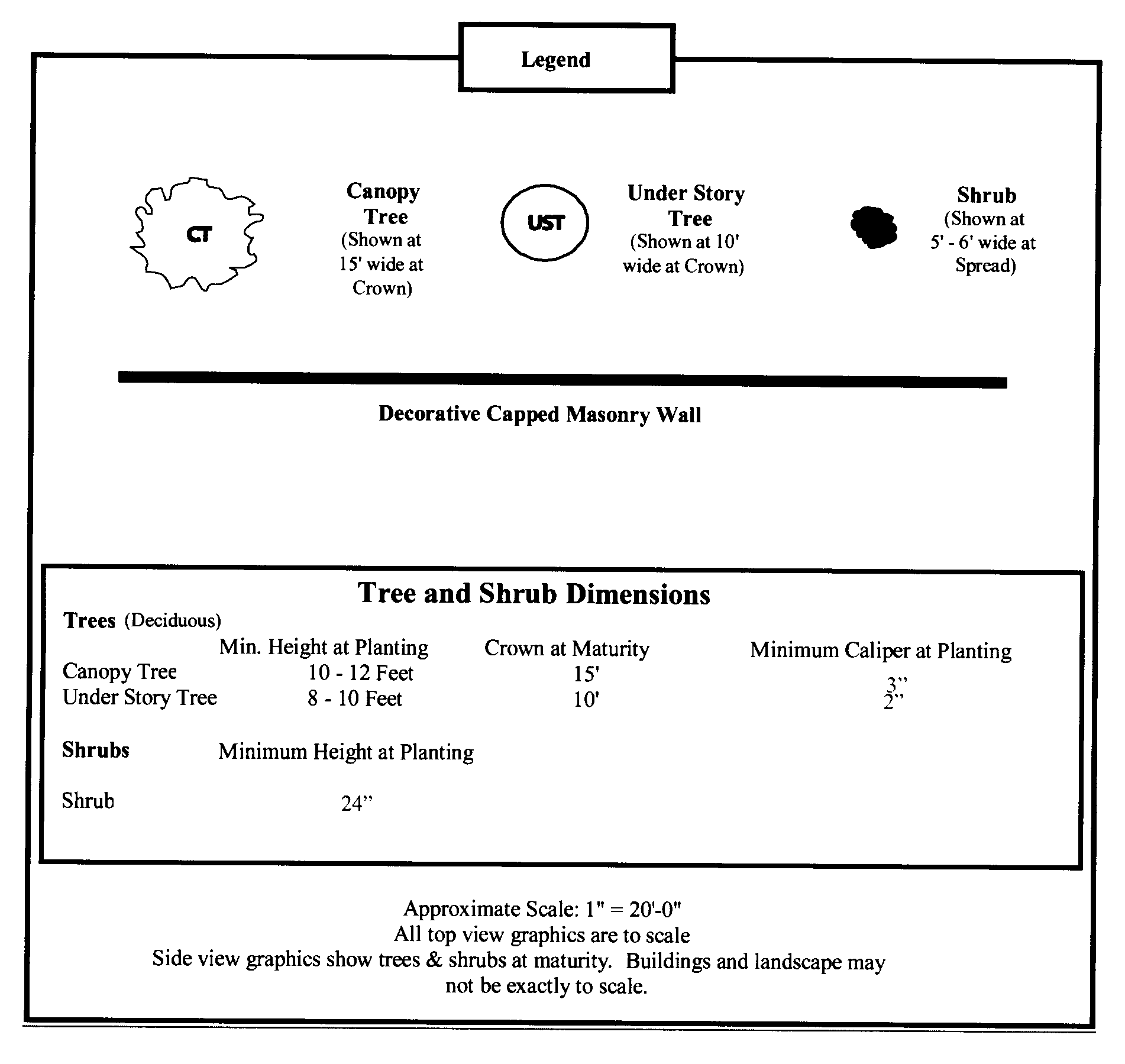
Figure 6.5.10.3A: Buffer A Specifications
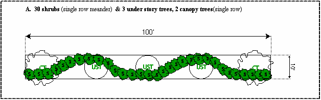
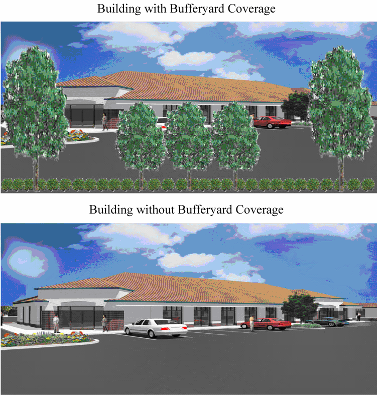
Figure 6.5.10.3B: Buffer B Specifications
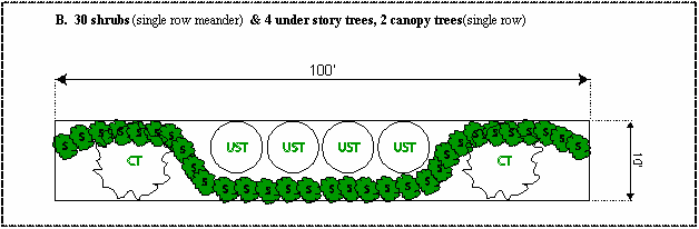
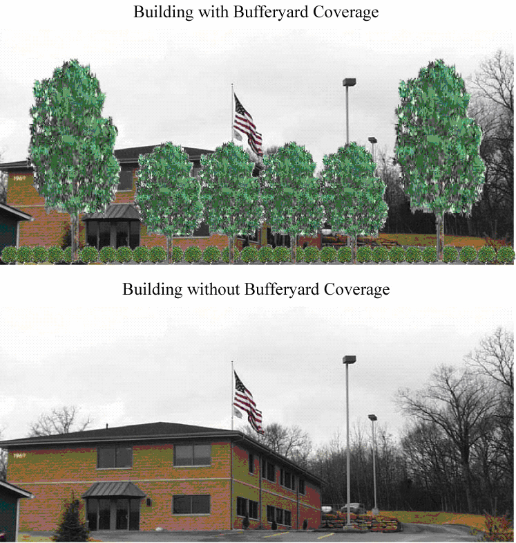
Figure 6.5.10.3C: Buffer C Specification
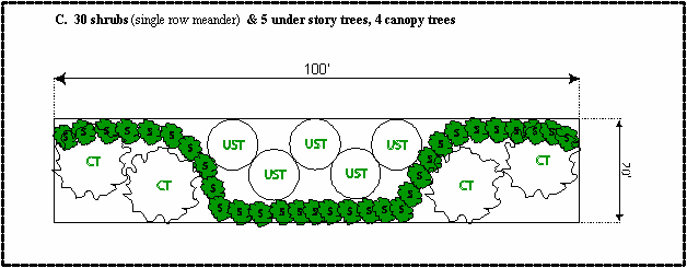
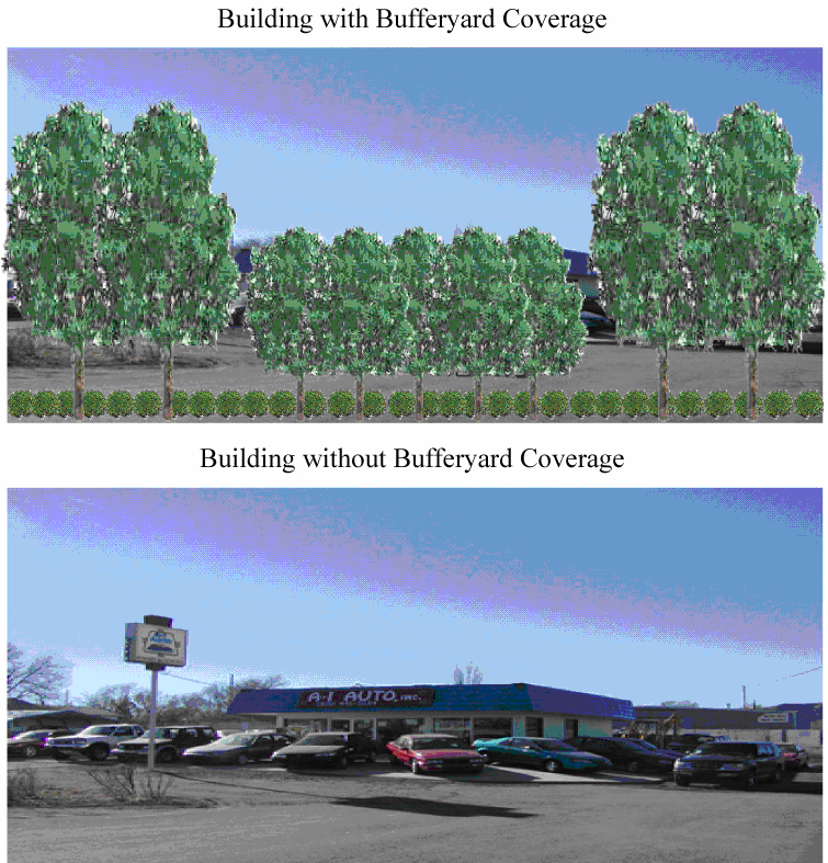
(Ord. No. 13-1453, § 4, 7-18-2013; Ord. No. 23-2053, § 1(Exh. A), 12-7-2023)
Sec. 6.5.11. - Intersection visibility.
Sight distance adjacent to public rights-of-way, points of access to off-street parking and loading areas shall be provided so as to permit visibility for vehicular and pedestrian traffic. When an access-way intersects a public right-of-way or when the subject property abuts the intersection of two or more rights-of-way, all structures and landscaping shall provide an unobstructed cross-visibility at a level between two and ten feet. No wall, fence, vegetative planting, earthen berm, or other visual obstruction between a height of two feet and ten feet above the average finished grade measured at the road centerline shall be established within the clear visibility triangle. In order to provide a clear view of intersecting roads to the motorist, there shall be a triangle area of clear visibility formed by two intersecting roads or the intersection of a driveway and a road. Nothing shall be erected, place, parked, planted, or allowed to grow in such a manner as to materially impede vision between a height of three feet and eleven feet above the grade for semi trucks, measured at the centerline of the road with the exception of publicly owned highway signs, utility poles and traffic control poles.
1.
Rights-of-way. The triangle shall be formed by extending the rights-of-way lines to a point where the lines intersect each other (point A); and from point (A), measuring to a point 30 feet along both rights-of-way lines points (B and C). See figure 6.5.11.1.
2.
Driveways. The triangle formed by extending the edge of the driveway and the right-of-way line to a point where the y intersect (point D); and from point (D), measuring to a point 15 feet to points designated as (E); and (F), and then connecting points (E) and (F) to form a line. See figure 6.5.11.2.
3.
Conflicts. This section controls any conflicts within landscaping requirements.
Figure 6-5.11.1
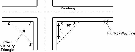
Figure 6-5.11.2
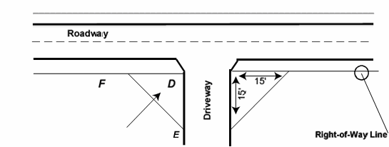
Sec. 6.5.12. - US 27 corridor land use and architectural appearance.
1.
Front facade. Any facade of any building that faces US 27 or a frontage road parallel to these facilities shall be deemed a front facade. The front facade and all facades within 40 feet of the front facade must be designed to achieve an "office-front" appearance and have a decorative front pedestrian entryway. The front facade of such building shall be faced with one of, or a combination of, the following:
• Face brick, stone, glass or similar material;
• Architecturally treated concrete;
• Stucco or other decorative coating applied to a code compliant building material in a manner as to create a harmonious design with other exterior materials.
• Architecturally designed metal fascia, soffit, and roof components can comprise a maximum of 25 percent of the front facade.
Front facades adjacent to US 27 shall avoid large blank areas between massing breaks, have a recognizable base and top, and include texture, revealed pilaster, change in plane (two feet minimum; four feet recommended), vertical variation in roof line, windows, lattice, accent trees, or equivalent. The "base" should visually relate to the proportion and scale of the building. Techniques for establishing a base include (but are not limited to) richly textured materials such as tile or masonry treatments; darker colored materials, mullions, panels, reveals, and/or enriched landscaping. The "top" should take advantage of the visual prominence of the building's silhouette. Techniques for clearly expressing a top may include (but are not limited to) cornice treatments, roof overhangs with brackets, richly textured materials such as tile, masonry, or fluted concrete), and/or differently colored materials. Colored "stripes" are not acceptable as the only treatment. Texture, reveals, and color may be appropriate in some applications. Said facing shall extend across the full front of the building and also extend a distance of not less than 40 feet on each side of the building adjacent to the front of the building.
The intent of this provision is that all structures visible from the US 27 corridor be designed and constructed in such a manner as to provide an aesthetically pleasing and harmonious development. All building facades should be made attractive through the use of careful detailing, especially at the base of buildings, along cornices, eaves, parapets, or ridge tops, and around entries and windows. Appearance may also be enhanced through the correct use of materials, expansion joints, and reveals. Window frames should appear substantial and should not be flush with the exterior finish. Glazing should be inset at least two inches from the front face of the exterior finish. Buildings shall be kept in good repair and appearance at all times and shall be compliant with all federal, state, and local building codes and other applicable laws. The following provisions shall be applicable to all sites located adjacent to US 27 or a frontage road running parallel to these facilities. All landscaping shall be located outside of the public right-of-way.
2.
Overhead doors and bays. No overhead doors, loading docks or bays shall be located on a facade facing US 27.
3.
Roof top utilities. Roof-top mechanical equipment shall be integrated into the overall mass of the building and shall be located and screened from public view by an appropriate barrier. At a minimum, roof mounted equipment shall be screened through the use of parapets, screen walls, equipment wells, mechanical room enclosures and similar design features. Screening devices other than parapet walls shall be designed as an integral part of the building mass. Picket fencing, chain-link fencing and metal boxes shall be avoided. The top of screens shall be at least as tall as the top of the equipment to be screened and shall provide additional height where larger equipment units are likely to be installed in the future. Cross section drawings should be prepared to illustrate the method in which the equipment will be screened from view of US 27. Flues, vents, and pipes on the roof should be painted a color that matches their background or roof material in order to reduce their visibility.
4.
Front and side yards; drainage. All front and side yards not used for structures, parking, sidewalks, access roads, or approved land use activity shall be graded with adequate drainage provided and shall be sodded and maintained in grass and landscaped areas with trees and shrubs. All drainage retention/detention facilities shall be designed as a project amenity and the design shall be approved by the administrative official. No drainage retention shall be located between the street and the front building facade unless the specific location and design is approved by the administrative official and must be predicted on a demonstrated need and lack of effective alternatives sites. The overall amount of landscaping required for each site will be based on the landscape plans approved by the city pursuant to the landscape ordinance within the Land Development Code. In no case shall approval of a plan be granted which does not contain at least the minimum standards as specified in these criteria.
5.
Front facade foundation landscaping. A minimum of at least one three- to five-gallon foundation shrub for every three linear feet of building front facade and one specimen tree of at least two inch caliper per 35 linear feet of building facade shall be placed along the foundation of any front facade facing US 27. The shrubs shall be a minimum of 30 inches tall at the time of planting. This landscaping requirement does not apply to portions of the building facade that provide access for pedestrians. The front facade landscaped area shall be at least five feet wide. Ground cover plants must fully cover the remainder of the five-foot landscaped area along the foundation.
6.
Perimeter landscaping for customer parking lots. Parking lots as well as related internal and perimeter landscaping shall comply with applicable Land Development Code. No parking shall be allowed to encroach into a required landscaped setback or buffer areas. A landscaped divider with concrete curbing shall be constructed to separate every 15 contiguous parking stalls. The landscape divider shall have a minimum of ten feet and shall comprise a minimum total 100 square feet of landscaped area. One deciduous tree shall be required for each such divider.
7.
Building entrances for customers. Entryways on building facades visible from US 27 shall be connected via pedestrian walkways with customer parking areas. The front facades shall include a major entry feature and fenestration over at least 25 percent of the facade's surface. A monolithic appearance shall be avoided. Entryways shall incorporate special materials, color, detailing, or equivalent architectural treatment at major entries. Primary building entries shall be highlighted through the massing of the building. Greater height can be used to highlight and accentuate entries in the form of corner tower elements, tall voids, or a central mass meeting an entry plaza. Conversely, smaller building masses can also communicate the location of entries. Landscaping at major building entryways shall be provider along with a sidewalk connecting to the front parking area.
8.
Underground utilities. New development and redevelopment shall have underground utilities.
Sec. 6.5.13. - Maintenance of plant materials and trees.
All plant material shall meet Florida Nursery No. 1 or better standards. All landscaped areas shall be appropriately irrigated and plants, grass, and trees shall be orderly and well maintained. Any areas of disturbed earth not in landscaped areas shall be sodded to reduce erosion and dust particles. Plant materials exhibiting evidence of insect pests, disease, and/or damage shall be removed within 60 days following city notification and be replaced in the next appropriate planting season or in one year, whichever occurs first.
Sec. 6.5.14. - Site plan procedures.
1.
Site plan; general. A site plan shall be required for all development within the US 27 corridor. The plan for development includes the dedication of rights-of-way or easements for roads, utilities or conservation measures, or otherwise includes the division of land into two or more units for resale. The applicant shall be required to obtain city commission approval of the subdivision plat compliant with chapter 13 subdivision regulations.
The site plan shall be approved by the administrative official upon a finding of compliance with all applicable laws and ordinance. Prior to approving the site plan the administrative official shall render a finding the proposed development.
2.
Mandatory pre-application. The applicant shall schedule a pre-application conference with the administrative official. The pre-application shall include a brief narrative of the proposed activity and a sketch of the proposed site plan.
3.
Site plan application; ownership/disclosure. Following the pre-application, the applicant shall file a site plan with the administrative official to commence the site plan review process. All applicants shall include a notarized affidavit showing each and every individual person having a legal and/or equitable ownership interest in the property upon which the application for site plan approval is sought, except publicly held corporations, in which case the name and address of the corporation and principal executive officers together with any majority stockholder will be sufficient. If the applicant is not the owner, the applicant must provide an original notarized statement from the current property owner authorizing representation of the specific site plan review application.
4.
Review by administrative official. Each application shall be reviewed by the administrative official and transmitted to appropriate city staff for review based upon the development issues surrounding the proposed site plan. The administrative official shall review each application for compliance with all applicable Land Development Regulations and other local, state, and/or federal laws.
5.
Conformance with Land Development Regulations required. All buildings, structures or uses shall be erected, altered, installed and maintained in full conformity with the provisions of the Land Development Regulations and approved site plans.
6.
Performance guarantee may be required. A performance guarantee may be required from applicants as a condition of site plan approval if all required on- or off-site infrastructure improvements are not in place at the time of site plan approval. The performance guarantee shall be in the form of a performance bond or other instrument recommended by the planning and zoning commission and approved by the city council after considering the recommendation of the city attorney. The performance guarantee shall be furnished and payable to the city in the sum of 125 percent of the total cost of the engineer's estimates for extension of potable water distribution system components; sanitary sewerage system components; street improvements, including acceleration and/or deceleration lanes, traffic control devices, markings signage, and/or related street improvements; sidewalks, curbs, and/or gutters; stormwater management improvements; and/or other improvements required in the site plan approval.. The terms of the performance guarantee may be modified by the city council after considering recommendations of staff and the city attorney.
7.
Information required in site plan. A site plan shall include, but not necessarily be limited to, the following requirements. With the exception of subsections (a) (1-3), the administrative official may waive or modify information requirements, information for site plan review after rendering a finding in writing that such requirements: 1) Are not necessary prior to site plan approval in order to protect the public interest or adjacent properties; 2) bear no relationship to the proposed project or its impacts; and 3) are found to be impractical based on the characteristics of the use, including the proposed scale, density/intensity, and anticipated impacts on the environment, public facilities and adjacent land uses.
a.
Title block.
i.
Name of development.
ii.
Name of owner/developer.
iii.
Scale.
iv.
North arrow.
v.
Preparation and revision date.
vi.
Location/street address of development.
b.
Project information to be included on site plan.
i.
Zoning (include any special districts).
ii.
Project site size (acreage and/or square footage).
iii.
Legal description.
iv.
Square footage together with maximum allowed/proposed building coverage.
v.
Impervious surface ratio, maximum allowed and proposed.
vi.
Pervious surface, including maximum allowed and proposed open space and green space.
vii.
Parking spaces, including minimum required and proposed as well as total handicapped spaces provided.
viii.
Delineate location of existing and proposed structures.
ix.
Denote existing and proposed development type by land use including density/intensity.
x.
Setbacks.
xi.
Finished floor elevation.
xii.
Proposed height and elevation of the crown of the road of the lowest adjacent street.
c.
Supplemental documentation.
i.
Identification of key persons (name, business name, mailing address, phone number).
(1)
Owner.
(2)
Owner's authorize agent.
(3)
Developer.
(4)
Surveyor.
(5)
Engineer, architect, and landscape architect.
(6)
Others involved in the application.
(7)
Verified statement showing each and every individual person having a legal and/or equitable ownership interest in the subject property, except publicly held corporations whose stock is traded on a nationally recognized stock exchange, in which case the names and addresses of the corporation and principal executive officers together with any majority stockholders will be sufficient.
ii.
A statement describing the objectives and characteristics of the development and indicating intent regarding the future selling or leasing of portions of the development.
iii.
A tabular summary keyed to the site plan that lists the proposed land uses, their location, acreage by land use, and gross floor area of each proposed use.
iv.
A statement explaining the desired phasing, including the approximate timing of commencement and completion of each phase, and the rationale for the phasing approach.
d.
Site plan: existing features. One or more maps and surveys at a scale of no less than one inch equals 100 feet, except the vicinity map, showing the following for the entire tract:
i.
The location of the development site in relation to existing streets.
ii.
A boundary survey and legal description prepared by a surveyor registered in the state.
iii.
Approximate topography defining the character of the land.
iv.
The comprehensive plan future land use designations, zoning classifications, and existing land uses for the development site and all properties within 100 feet of property lines and adjacent rights-of-way.
v.
The location of all existing structures, rights-of-way, easements and other natural and man-made features on site and within 100 feet of the property lines and adjacent rights-of-way.
e.
Site Plan: proposed features. One or more maps at the same scale as the maps of existing features shall include the following:
i.
A schematic representation of proposed land uses (including common open space), conceptual building locations, parking lots, and driveway entrances and exits.
ii.
A delineation of proposed roads with the functional classification of streets and an indication of required off-site street improvements.
iii.
A schematic depiction of existing and proposed surface water management elements, including wetlands and major detention facilities.
iv.
The general location and size of any community facility include within the development.
v.
Any proposed phasing of the project.
f.
Schedule of amenity/compatibility features. A schedule indicating any proposed amenities or compatibility features which may include: Natural open or landscaped areas; buffers; walls, berming, and screening; Waterway and flood protection measures.
g.
Miscellaneous information. Any other information needed to satisfy the criteria in 8 c) below.
8.
Site plan review criteria. The site plan shall effectively demonstrate how the following conditions shall be met:
a.
Unified development. All lots within the development shall be linked with driveways and a pedestrian network and will have other unifying features, such as a unified signage plan, landscape plan, architectural features, and the like (all of which are designed to promote a unified, park-like environment).
b.
Compatibility. The location and arrangement of uses and buildings, roads, driveways, parking areas, pedestrian ways, and other features shall be compatible with surrounding land uses.
c.
Access, egress, and on- and off-site circulation system vehicular and pedestrian. The proposed development shall be planned such that the traffic generated can be easily accommodated without causing excessive volumes of traffic, particularly on residential streets.
The plan shall demonstrate compliance with chapter 6, article 4 criteria for separation of pedestrian and vehicular traffic and on-site vehicular circulation system that avoids conflict between cargo carriers, on one hand, and vehicular movement of employees and patrons, on the other hand.
d.
Open space, buffers, screening, and facade and parking lot landscaping. All parts of the site not used for buildings or impervious roadways, driveways, and parking lots or other impervious surfaces shall be landscaped pursuant to land development requirements.
9.
Special conditions of approval. In order to ensure compliance with section 6.4.6.J. "compatible land use," where necessary to ensure compatibility of buildings and uses with each other and with off-site properties, the administrative official or the city commission, on appeal, may require significant revisions to site plans. For example, if a potential incompatibility of a land use, structure, or activity cannot be adequately addressed by the required buffers and screening, the location, size, scale, intensity, or other attributes of the use, structure, or activity shall be modified to comply with the provisions of the Land Development Code.
10.
Effective period of site plan approval. Approval of a site plan shall be effective for a period of 18 months.
11.
Conformance to site plan approval and minor amendments thereto. No permits shall be issued by the city, and no development shall commence unless in conformance with the approved site plan, unless a change or deviation is approved under provisions of the Land Development Regulations. The administrative official may approve minor changes and deviations from the approved site plan which are in compliance with the provisions and intent of this ordinance, and which do not depart from the principal concept of the approved site plan. Examples would be a minor shift of a parking lot location. All other requested changes and deviations shall be referred to the city commission.
Sec. 6.6.1. - General intent.
The intent of article 6.6 is to implement the historical appearance design standards (HADS). The HADS will be enforced in all new development in an effort to improve the aesthetics and traditional Main Street atmosphere of Haines City. New developments and renovations inside the central business district (CBD) and central business district extra (CBDX) shall conform to the design standards listed below.
The economic vitality as well as the aesthetic quality of each business enterprise is important, and both are linked in part to the success of surrounding commercial establishments. Studies have shown that thoughtful design improvements often lead to greater sales for a business. Similarly, the physical character of the CBD and CBDX contribute greatly to the overall image of the community for its residents, customers and visitors. These guidelines have been established in hopes that several important public and private objectives can be met, including:
•
Enhancement of the commercial success by ensuring a pleasant experience for business patrons.
•
Preservation and enhancement of historic buildings, streetscape, and architectural features.
•
Recognition that the CBD and CBDX are a community with unique qualities and characteristics which should be reinforced by planning and improvements specific and appropriate to this place.
The appearance plans shall be reviewed using the historical appearance designs standards. During the review city staff may solicit the input of the Haines City Main Street Design Committee for a review of appropriate historic preservation guidelines.
HADS—Historical appearance design standards defined. Historical appearance design standards (HADS) are defined for the purposes of these regulations as standards to be used for all new development in the central business district (CBD) and central business district extra (CBDX) zone districts within Haines City.
HAD district, where permitted. The HAD district may hereafter be established within areas classified central business district (CBD) and central business district extra (CBDX).
(Ord. No. 08-1328, § 2, 5-15-2008; Ord. No. 12-1417, § 9, 3-15-2012)
Sec. 6.6.2. - Historical appearance design standards (HADS).
The following regulations are applicable to development on lands zoned CBD and CBDX:
1.
Any new construction and redevelopments shall be subject to the following physical requirements:
a.
Height requirements:
1.
All new buildings shall be a minimum of two stories.
2.
New one story buildings shall require conditional use approval.
3.
Additions or modifications to existing one story buildings are not required to meet the minimum two story requirement, but shall conform to all other HADS.
4.
Existing one story structures destroyed or deteriorated to the extent of 50 percent or more shall not be required to meet the minimum height requirement, but shall conform to all other HADS.
b.
The exterior finish on all new construction shall be limited to:
1.
Concrete masonry units with stucco.
2.
Reinforced concrete with stucco.
3.
Cementitious fiber board siding.
4.
Reserved.
5.
Brick.
6.
Stone.
7.
Decorative metal (corrugated metal not permitted).
Cementitious fiber board siding
c.
The following shall be located in rear yards or side yards not facing side streets:
1.
Window and wall air conditioners.
2.
Electricity utility meters.
3.
Air conditioning compressors.
4.
Irrigation and pool pumps.
d.
The following shall be located in rear yards only:
1.
Antennas.
2.
Satellite dish antennas less than 20 inches in diameter.
3.
Permanent barbecues.
4.
Sliding doors and sliding windows.
e.
The following are prohibited:
1.
Plastic, inoperable or undersized shutters (the shutter or shutters must be sized so as to equal the width that would be required to cover the window opening)
2.
Detached mailboxes.
3.
Clotheslines.
4.
Satellite dish antennas greater than 20 inches in diameter.
5.
Reflective and/or bronze-tint glass.
6.
Plastic or PVC roof tiles.
7.
Backlit awnings.
8.
Glossy-finish awnings.
9.
Fences made of chain link, barbed wire, post and cable or plain wire mesh.
f.
Required for all buildings:
1.
An expression line shall delineate the division between the first story and the second story. A cornice shall delineate the top of the facades. Expression lines and cornices shall either be moldings extending a minimum of two inches, or jogs in the surface plane of the building wall greater than two inches.
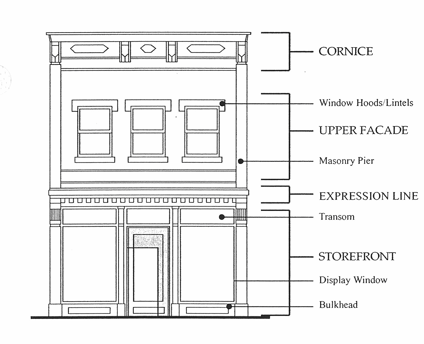
g.
Walls, fences and hedges:
1.
Height:
Fences in front yards shall have a maximum height of three feet.
Fences in side and rear yards shall have a maximum height of eight feet. Ornamental pillars and posts may extend up to six inches more, to a height of 8.5 feet.
2.
Permitted finish materials:
a.
Wood (termite resistant): attractive side facing street, painted white, left natural or painted/ stained with colors reviewed by the Administrative Official.
b.
Concrete masonry units with decorative stucco.
c.
Reinforced concrete with decorative stucco.
d.
Wrought iron.
e.
Brick.
3.
Location of fences and walls:
Fences and garden walls may run along the property line of lots that have buildings built to the property line and along alleys with a maximum height of eight feet. Ornamental pillars and posts may extend up to six inches more, to a height of 8.5 feet. Buildings that are not built to the property line shall only be permitted fences that are a maximum height of three feet along the property line.
h.
Columns, arches, piers, railings and balustrades.
1.
General requirements: Column and piers shall be spaced no farther apart than they are tall.
2.
Permitted finish materials:
a.
Columns:
i.
Wood (termite resistant), painted or natural.
ii.
Cast iron.
iii.
Concrete with smooth finish.
b.
Arches:
i.
Concrete masonry units with stucco.
ii.
Reinforced concrete with stucco.
iii.
Brick.
c.
Piers:
i.
Concrete masonry units with stucco.
ii.
Reinforced concrete with stucco.
iii.
Brick.
d.
Railings and balustrades:
i.
Wood (termite resistant), painted or natural.
ii.
Wrought iron.
3.
Permitted configurations:
a.
Columns:
i.
Square, six-inch minimum, with or without capitals and bases.
ii.
Round, six-inch minimum outer diameter with or without capitals and bases.
iii.
Classical orders.
b.
Arches:
i.
Semi-circular and segmental.
c.
Piers:
i.
Eight-inch minimum dimension.
d.
Porches:
i.
Railings two to three inches minimum diameter, must be a minimum of 36 inches in height if porch is more than 30 inches above ground level.
ii.
Balustrades four inches maximum spacing for porches more than 30 inches above ground level, six-inch maximum spacing for porches less than 30 inches above ground level.
i.
Roofs and gutters:
1.
Permitted roof types:
a.
Gabled, hipped, gambrel and saltbox roofs shall be permitted.
b.
Flat roofs shall be concealed with parapets along the street frontage.
c.
Applied mansard roofs are not permitted.
Roof types
Parapets
d.
Exposed rafter ends (or tabs) at overhangs are strongly recommended.
Exposed Rafter Ends
e.
Downspouts are to match gutters in material and finish.
2.
Permitted finish materials:
a.
Metal:
i.
Galvanized.
ii.
Copper.
iii.
Aluminum.
iv.
Zinc-alum.
b.
Shingles:
i.
Asphalt or metal, "dimensional" type.
ii.
Slate.
iii.
Cedar shake.
c.
Tile:
i.
Clay.
ii.
Terra cotta.
iii.
Concrete.
iv.
Stone coated steel.
d.
Gutters:
i.
Copper.
ii.
Aluminum.
iii.
Galvanized steel.
e.
Flat roofs hidden with parapets are exempt from the required finish materials.
3.
Permitted roof configurations:
a.
Metal or copper:
Standing seam, 24-inch maximum spacing, panel ends exposed at overhang.
Standing Seam
b.
Shingles:
c.
Tile:
d.
Gutters:
Rectangular section.
Square section.
Half-round section.
j.
Windows, skylights and doors.
1.
General requirements:
a.
Rectangular window openings facing streets shall be oriented vertically.
2.
The following accessories are permitted:
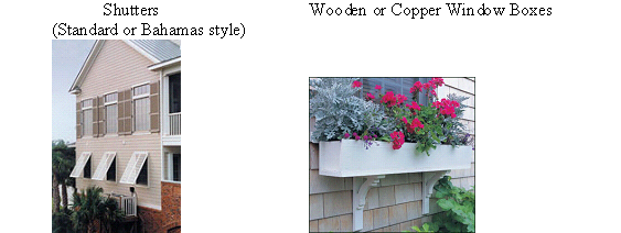
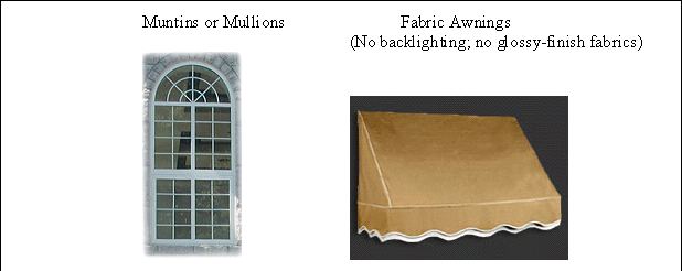
3.
Finish materials:
Window, skylights and storefronts: Wood, aluminum, copper, steel, vinyl clad wood.
Doors: wood or metal.
4.
Permitted configurations:
Windows shall be recessed a minimum of two inches from the exterior face of the facade. Residential bedroom windows shall be oriented vertically and meet the required opening criteria of at least 20 inches wide and 24 inches in height and a 5.0 square foot opening.
Windows: rectangular, square, semi-circular, octagonal.
Window operations: Casement, single and double hung, industrial, fixed frame (36 square feet maximum).
Skylights: Flat to the pitch of the roof.
Door Operations: casement, French, sliding (rear only).
k.
Balconies and porches: Balconies and porches shall be made of painted wood or decorative metal.
l.
Buildings shall have symmetrical pitched roofs with slopes no less than 5:12, except that porch roofs may be sheds with pitches no less than 2:12.
m.
Permitted colors: The administrative official shall review the proposed color scheme for all new developments and redevelopments to recommend the color scheme is historically appropriate.
(Ord. No. 08-1328, § 2, 5-15-2008; Ord. No. 12-1417, § 9, 3-15-2012; Ord. No. 20-1695, § 2, 8-6-2020)