
Hillsboro City Zoning Code
SUBCHAPTER 12.27
OVERLAY ZONES
12.27.010 - Overlay Zones.
There are 5 overlay zones in the City:
A.
RFO Regulatory Floodplain Overlay zone;
B.
SNRO Significant Natural Resource Overlay zone;
C.
CRO Cultural Resource Overlay zone;
D.
PUD Planned Unit Development; and
E.
SID Special Industrial District.
(Ord. 6401 § 1, 2022)
12.27.020 - Locational Characteristics.
Overlay zones are applied on properties or portions of properties to modify or supplement the regulations of the underlying base zone in recognition of historic sites, environmental conditions, external environmental impacts, or regulatory requirements. The Regulatory Floodplain Overlay zone implements the FP Floodplain Comprehensive Plan Land Use Map designation and the requirements of the National Flood Insurance Program in areas that the Federal Emergency Management Agency and the City Floodplain Administrator have deemed to be at risk of flooding according to best available data on the boundaries of the Base Flood and the Base Flood Elevation at a given location. The Significant Natural Resource Overlay zone and the Cultural Resource Overlay zone implement Comprehensive Plan goals and policies. The Special Industrial District is applied only on land with the Industrial Plan Designation, to implement certain Metro goals regarding retention of large industrial lots. Except as noted in this Subchapter, overlay zone provisions do not change Use Category status or the development standards of the underlying base zone. Boundaries of an overlay zone may be either property lines or site-specific environmental boundaries.
(Ord. 6401 § 1, 2022; Ord. 6276 § 1, 2018)
12.27.030 - Organization within this Subchapter.
A.
Common Elements. Each section in this Subchapter contains the following components. Due to the unique character of each overlay zone, sequence and terminology varies among zones.
1.
Purpose. Purpose statements for each overlay zone are descriptive of the overlay's characteristics and intent, and are drawn from the Comprehensive Plan and/or the Community Development Code. Purpose statements are informational and not intended to be regulations.
2.
Applicability. Each overlay zone is applied based on specific conditions as described in each section. Overlay zones may be applicable to an entire property or to a portion of property. More than 1 overlay zone may apply to a property or portion thereof.
3.
Administration and Regulatory Coordination. Land Uses and development activities in some overlay zones may be subject to regulation by other agencies. The jurisdiction of these agencies may vary within an overlay zone.
4.
Regulations on Permitted Uses or Activities. The Use categories status or development standards of the underlying base zone may be modified or supplemented to accomplish the purpose of the overlay zone in reducing negative impacts on an identified resource.
5.
Applications and Processes for Land Use Approvals. Certain types of land use application approvals are required in most overlay zones to accomplish the purposes of the zone. Submittal materials and criteria for these applications are also related to demonstrating compliance with the purposes of the overlay zone.
6.
Establishment or Modification of Overlay Boundaries. The boundaries of some overlay zones may be subject to change either through development activity or environmental conditions. Each overlay zone has a unique process to establish or modify the overlay boundary.
(Ord. 6401 § 1, 2022)
12.27.100 - RFO Regulatory Floodplain Overlay.
The Regulatory Floodplain Overlay includes the following sections:
12.27.105 Purposes
12.27.107 Liability
12.27.110 Applicability, Code Interpretation, and Floodplain Boundary/Base Flood Elevation Interpretation.
12.27.115 Administrative and Regulatory Coordination
12.27.120 Uses and Activities Permitted
12.27.125 Uses and Activities in the Floodway
12.27.130 Minor Uses and Activities Permitted with Type II Approval
12.27.135 Major Uses and Activities Permitted with Type III Approval
12.27.140 Additional Standards
12.27.145 Variances from RFO Standards
(Ord. 6401 § 1, 2022)
12.27.105 - Purposes.
Consistent with the provisions of the Code of Federal Regulations related to local administration of the National Flood Insurance Program (44 CFR 59—76); ORS 197.175; Article XI, section 2 of the Oregon Constitution; and the Purpose of the Community Development Code cited in Section 12.01.110, the City of Hillsboro has responsibility for planning, adopting, and enforcing land use regulations to manage floodplains identified by FEMA or as otherwise identified by the Floodplain Administrator or City Engineer within the jurisdiction of the City of Hillsboro. The Regulatory Floodplain Overlay (RFO) zone is established for the following purposes:
A.
To reduce potential danger and serious damage to life and property from flooding;
B.
To regulate topographic alterations within the floodplain that may affect upstream or downstream flood levels;
C.
To regulate use of areas subject to flooding and encroachment into the floodplain by restricting Uses subject to flood damage; and
D.
To reduce the financial burden on the community that results from flood damage.
E.
To protect the beneficial ecological, hydraulic, and hydrologic functions of floodplains.
(Ord. 6401 § 1, 2022; Ord. 6276 § 1, 2018; Ord. 6192 § 1, 2016)
12.27.107 - Liability.
The degree of flood protection required by this Community Development Code is based on scientific and engineering considerations and is considered reasonable for regulatory purposes. Larger floods can and will occur on rare occasions, and flood heights may be increased by man-made or natural causes. This Community Development Code is not intended to imply and should not be construed to mean that land outside floodplain areas or uses permitted within floodplains will be free from flooding or flood damages at all times. Nothing in this Community Development Code creates any liability on the part of the City of Hillsboro, any officer or employee thereof, or the Federal Insurance and Mitigation Administration for any flood damage that may result from reliance on this Community Development Code or any administrative decision lawfully made hereunder.
(Ord. 6401 § 1, 2022; Ord. 6192 § 1, 2016)
12.27.110 - Applicability, Code Interpretation, and Floodplain Boundary/Base Flood Elevation Interpretation.
A.
Applicability.
1.
The Regulatory Floodplain Overlay (RFO) zone applies to areas of special flood hazard (also known as the "1% annual chance floodplain," "100-year floodplain," "floodplain") identified by the Federal Insurance Administration in a scientific and engineering report titled "Flood Insurance Study for Washington County, Oregon and Incorporated Areas" dated October 19, 2018, with accompanying Flood Insurance Maps, which are hereby adopted by reference and declared to be a part of the Community Development Code. The Flood Insurance Study is on file and available at the Planning Department at 150 E Main Street, Hillsboro, Oregon. The Flood Insurance Study and accompanying FIRMs are hereby adopted by reference and declared to be a part of this ordinance. The RFO may also apply to areas identified by the Floodplain Administrator or City Engineer under paragraph B, Boundary Interpretation, below. All proposed construction, including placement of manufactured homes, in the RFO requires a Floodplain Activity Permit (see CDC Section 12.80.070 Floodplain Activity), except construction meeting the standards of Section 12.27.120.
2.
No structure or Use shall be located, extended, converted, expanded, enlarged, replaced, or structurally altered within the boundaries of the RFO without compliance with this Subchapter.
3.
No topographic alteration shall occur within the boundaries of the RFO without compliance with this Subchapter.
4.
These requirements are in addition to the standards of the underlying base zone and to any other standards in this Subchapter. Where conflicts may occur among standards, the standards of this Subchapter supersede all other standards.
B.
Code Interpretation. An applicant may request a Director's Interpretation of the provisions of the CDC under Section 12.80.050. In the interpretation and application of this subchapter, all provisions shall be:
1.
Considered as minimum requirements;
2.
Liberally construed in favor of the governing body; and,
3.
Deemed neither to limit or repeal any other powers granted under State statutes.
C.
Floodplain Boundary/Base Flood Elevation Interpretation. The City Engineer and Floodplain Administrator are authorized to make interpretations of the exact location of the boundaries of the RFO (for example, where there appears to be a conflict between a mapped boundary and actual field conditions) and to interpret the National Flood Insurance Program data, local data, and data from other parties to determine the location of special flood hazard area boundaries. The City Engineer and Floodplain Administrator are authorized to interpret the effective Flood Insurance Study to determine the approximate Base Flood Elevation when the project location is between locations where FEMA specifies a Base Flood Elevation in the Flood Insurance Study. The City may obtain, review, and reasonably utilize any flood-related data available from a Federal, State, or other source to administer Section 12.27.100 and may require the applicant to submit a survey of site topography prepared by a Professional Land Surveyor.
(Ord. 6401 § 1, 2022; Ord. 6276 § 1, 2018; Ord. 6192 § 1, 2016)
12.27.115 - Administrative and Regulatory Coordination.
A.
Designation of the Local Floodplain Administrator. The Planning Director or their designee is hereby appointed to administer and implement the requirements and provisions of Sections 12.27.100 and 12.80.070.
B.
Responsibilities of the Local Floodplain Administrator. The Local Floodplain Administrator shall ensure that:
1.
The requirements of the Regulatory Floodplain Overlay have been satisfied on any development therein;
2.
All development permits are reviewed to determine that all necessary permits have been obtained from those Federal, State, or local governmental agencies from which prior approval is required;
3.
All development permits are reviewed to determine if the proposed development is located in the floodway. If located in the floodway, assure that the encroachment provisions of Section 12.27.100 are met;
4.
Where base flood elevation data is provided through the Flood Insurance Study, FIRM, or required as in Section 12.27.110, the actual elevation (in relation to mean sea level) of the lowest floor (including basements and below-grade crawlspaces) of all new or substantially improved structures, and whether or not the structure contains a basement, are obtained and recorded;
5.
For all new or substantially improved floodproofed structures where base flood elevation data is provided through the Flood Insurance Study, FIRM, or as required in Section 12.27.110:
a.
the actual elevation (in relation to mean seal level) is verified and recorded, and
b.
the floodproofing certifications are maintained;
6.
Subdivision proposals and other proposed new development, including manufactured home parks or subdivisions, are reviewed to determine whether such proposals will be reasonably safe from flooding. If a subdivision includes new development in a flood-prone area, any such proposals shall be reviewed to assure that:
a.
such proposals minimize potential for flood damage within the flood-prone area,
b.
all public utilities and facilities, such as sewer, gas, electrical, and water systems are located and constructed to minimize or eliminate flood damage,
c.
adequate drainage is provided to reduce exposure to flood hazards, and
d.
all development-related activities comply with Section 12.27.100;
7.
If the base flood elevation has not been provided or is not available from another authoritative source, it is generated for subdivision proposals and other proposed developments of at least 50 lots or 5 acres (whichever is less), and all permits are reviewed that the building sites are expected to be reasonably safe from flooding;
8.
All records pertaining to the provisions of Section 12.27.100, including any variances granted, are maintained and available for public inspection.
C.
Other Affected Agencies. The regulations of other agencies may apply to development proposals and other projects within the floodplain. These agencies include the Federal Insurance Administration, the Federal Emergency Management Agency, the U.S. Army Corps of Engineers, the Oregon Department of State Lands, the U.S. Fish and Wildlife Service, the Environmental Protection Agency, the Oregon Department of Fish and Wildlife, Washington County, and Clean Water Services.
D.
Notification. The City will notify affected agencies, adjacent communities, and the Department of Land Conservation and Development of specific development proposals and watercourse alterations within the floodplain prior to the issuance of City permits. Applicants are encouraged to contact affected agencies before development plans are completed to determine requirements and restrictions that may be imposed by those agencies. The Floodplain Administrator shall submit evidence of such notifications to the Federal Insurance Administration.
E.
Agency Coordination and Approvals.
1.
When a development will alter a watercourse within the floodplain, modify floodplain boundaries, or modify Base Flood Elevations, the person responsible for the development or other project shall obtain conditional approvals or comments from other affected agencies, including FEMA, and submit the approvals or comments to the City prior to requesting City permits and inspections, commencing work on the site in the floodplain, and/or after completing work on the site, as determined by the City. Such approvals or comments shall include, but may not be limited to:
•
An application for a Conditional Letter of Map Revision from FEMA, which may entail site-specific studies prepared by a qualified expert of habitat (e.g., Endangered Species), hydrology, hydraulics, and/or other topics related to the project or its impacts; and
•
An application for a Letter of Map Revision (LOMR) submitted to FEMA depicting as-built conditions within 6 months of project completion.
2.
The applicant is responsible for completing and submitting application forms, preparing technical data and studies to support evaluation of the applications, and paying any processing or application fees to other agencies. The complete submittal packages (applications as well as supporting documentation and models) shall be provided to the City upon request.
3.
The Floodplain Administrator and City Engineer are under no obligation to sign a Community Acknowledgement Form for a FEMA application until it has been demonstrated that the project as proposed meets the requirements of this Code and all applicable State and Federal laws.
4.
The applicant shall construct the project as approved and required by any applicable reviews, conditions of approval, and/or permitting processes. If deviations from or revisions to reviewed or approved plans are desired, the applicant shall request authorization in advance from the City as well as other regulatory agencies. The City may require additional reviews, public notices, and/or permits prior to authorizing deviations from approved project plans.
(Ord. 6401 § 1, 2022; Ord. 6276 § 1, 2018; Ord. 6192 § 1, 2016)
12.27.120 - Uses and Activities Permitted.
A.
Permitted Uses and Activities. If allowed in the underlying base zone, the following Uses and activities may be permitted in the RFO without the approval of a Floodplain Activity permit, subject to a review by the Floodplain Administrator of the activities proposed as well as the applicant's compliance with the standards listed in subsection B below:
1.
Agricultural Uses (excluding raising livestock) with no structures except boundary fences that have been approved under a Fence Permit per Section 12.80.060;
2.
Residential accessory Uses not including structures, topographic alterations, or buildings;
3.
Recreational Uses including minor structures (such as picnic tables or barbecues), provided the minor structures are firmly anchored and built of flood-resistant materials;
4.
Underground utility facilities constructed and installed to minimize water damage and flood water infiltration;
5.
Repair, reconstruction, or improvements to an existing structure, provided that the project is not a substantial improvement, is within the existing footprint of the structure, and is constructed to minimize flood damage through use of flood-resistant materials, anchoring, elevation, and protection of on-site public and private utilities;
6.
Construction of public streets, light rail transit tracks and associated bridges and crossings, bikeways, and footpaths which implement the adopted Transportation System Plan, in compliance with the following standards:
a.
The construction has been verified by the City Engineer as complying with Section 12.27.100, and
b.
Travel surfaces of the roadway, light rail transit track and associated bridge and crossing are elevated 1 foot or more above the elevation of the Base Flood;
7.
Projects whose primary purpose is wetland or floodplain, restoration, or other enhancement, and that do not involve topographic alterations.
B.
Standards for Permitted Uses and Activities. The Uses and activities in subsection A are permitted only in compliance with the following standards:
1.
The Uses or activities remain in compliance with applicable Federal, State, and local requirements; and
2.
Unless otherwise determined by the Review Authority, a registered professional civil engineer has certified that, based on hydrologic and hydraulic analyses performed in accordance with standard engineering practice, the Use or activity will not reduce the site's capacity to carry the base flood or cause any increase in the base flood level.
(Ord. 6401 § 1, 2022; Ord. 6276 § 1, 2018; Ord. 6192 § 1, 2016; Ord. 6149 § 1, 2015)
12.27.125 - Uses and Activities in the Floodway.
A.
Development Permit Review. All development permits shall be reviewed to determine if the proposed development involves the floodway.
B.
Allowed and Prohibited Uses. With the exception of the Uses listed below, no use, activity, encroachment, alteration, development, or construction shall be allowed in the floodway:
1.
The Uses and activities permitted in the RFO under Section 12.27.120;
2.
Above-ground utility structures as cited in Section 12.27.130;
3.
Bridges and other water-dependent uses; and
4.
Erosion control activities.
C.
Standards for Uses and Activities Allowed in the Floodway. All Uses and activities allowed in the floodway shall comply with the following standards:
1.
Certification by a registered professional civil engineer is provided demonstrating through hydrologic and hydraulic analyses performed in accordance with standard engineering practice (e.g., a "no-rise analysis") that encroachments shall not result in any increase in flood levels during the occurrence of the base flood discharge; and
2.
All other applicable provisions of Section 12.27.100 are met.
(Ord. 6401 § 1, 2022; Ord. 6276 § 1, 2018)
12.27.130 - Minor Uses and Activities Permitted with Type II Approval.
The Uses listed in Table 12.27.130-1 may be permitted in the RFO subject to the listed standards, upon approval of an administrative Minor Floodplain Activity or Use (FA). The criteria for approval of a minor FA are listed in Section 12.80.070. An application for a minor FA shall be processed as a Type II procedure under the provisions of Section 12.70.040. The Planning Director may determine that an application for Minor Floodplain Activity should be processed as a Type III procedure, based on the factors in Subsection 12.80.070.C.3.
(Ord. 6401 § 1, 2022)
(Ord. 6401 § 1, 2022; Ord. 6276 § 1, 2018; Ord. 6192 § 1, 2016)
12.27.135 - Major Uses and Activities Permitted with Type III Approval.
The Uses listed in Table 12.27.135-1 may be permitted in the RFO subject to the listed standards, upon approval of a quasi-judicial Major Floodplain Activity or Use (FA). The criteria for approval of a major FA are listed in Section 12.80.070. An application for a major FA shall be processed as a Type III procedure under the provisions of Section 12.70.050.
(Ord. 6401 § 1, 2022; Ord. 6276 § 1, 2018; Ord. 6192 § 1, 2016; Ord. 6120 § 1, 2015)
12.27.140 - Additional Standards.
Floodplain activity shall be subject to the additional standards listed below.
A.
Floodplain Location on Applications. The location of the Base Flood Elevation, as established by the most current FIRM, Flood Insurance and Floodway Maps, or the best available information, shall be shown on any development application on property including floodplain areas, even if the application proposes no activity or use in the floodplain. If the floodplain activity involves a critical facility as described in Federal Emergency Management Agency publication #543, the boundary of the 0.2% chance ("500-year") floodplain as shown on the effective Flood Insurance Rate Map shall be shown as well. If the Base Flood Elevation is not available, it shall be calculated by a registered professional engineer.
B.
Alteration of Watercourses Within the Floodplain.
1.
The City shall notify Washington County, DLCD, the Corps, CWS, DSL, and any adjacent jurisdictions prior to any alteration of watercourses within the City and shall submit evidence of such notification to the Federal Insurance Administration.
2.
An alteration to watercourses within the floodplain must be approved by the City Engineer prior to construction.
3.
An alteration to watercourses within the floodplain shall be designed and maintained so that flood-carrying capacity is not diminished.
4.
Approvals and/or reviews from other agencies may be required (12.27.115(C) and (E)).
C.
In areas where a regulatory floodway has not been designated, no new construction, substantial improvements, or other development (including fill) shall be permitted within Zones A1-30 and AE on the community's FIRM, unless it is demonstrated that the cumulative effect of the proposed development, when combined with all other existing and anticipated development, will not increase the water surface elevation of the base flood more than one foot at any point within the community.
D.
Structures in the floodplain shall also be subject to the applicable various specialty codes and standards in Hillsboro Municipal Code Section 11.04.010.
(Ord. 6401 § 1, 2022; Ord. 6276 § 1, 2018; Ord. 6192 § 1, 2016)
12.27.145 - Variances from RFO Standards.
A.
Definition. For floodplain management purposes, a Variance means a grant of relief by a community from the terms of a floodplain management regulation.
B.
Criteria and Procedures. A variance from one or more of the RFO standards in Sections 12.27.120, 12.27.125,12.27.130, 12.27.135, and 12.27.140 may be approved by the Review Authority upon approval of a Variance. The criteria for approval of a Variance from RFO standards are listed in Subsection 12.80.152.E. An application for an RFO Variance shall be processed as a Type III procedure under the provisions of Section 12.70.050.
C.
Additional Provisions Regarding RFO Variances.
1.
Variances may be approved for the reconstruction, rehabilitation, or restoration of structures listed on the National Register of Historic Places, the State Inventory of Historic Places, or the Cultural Resource Inventory, without regard to the Variance criteria in Subsection 12.80.152.E, provided that the reconstruction, rehabilitation, or restoration does not require a topographic alteration.
2.
Variances as interpreted in the National Flood Insurance Program are based on the general zoning law principle that they pertain to a physical piece of property; they are not personal in nature and do not pertain to the structure, its inhabitants, nor economic or financial circumstances. As such, Variances from the requirements of the RFO should be quite rare. Insurance premium rates are determined according to actuarial risk and are not modified by the granting of a variance to the standards of the RFO.
(Ord. 6401 § 1, 2022; Ord. 6276 § 1, 2018; Ord. 6192 § 1, 2016)
12.27.200 - SNRO Significant Natural Resources Overlay.
The Significant Natural Resources Overlay includes the following sections:
12.27.205 Purposes
12.27.215 Administrative and Regulatory Coordination
12.27.220 Exempt, Permitted and Prohibited Uses and Activities
12.27.230 General Development Standards
12.27.235 Standards for Specific Development Types within a Resource Site or Impact Area
12.27.240 Compensatory Mitigation Standards
12.27.245 Adjustments from Standards of Underlying Zoning
12.27.250 Boundary Verification and Modification
(Ord. No. 6473, §§ 1, 2(Exh. A), 6-18-2024)
Editor's note— Ord. No. 6473, §§ 1, 2(Exh. A), adopted June 28, 2025, amended 12.27.200, 12.27.205, 12.27.210, 12.27.215, 12.27.220, 12.27.225, 12.27.230, 12.27.235, 12.27.240, 12.27.245, 12.27.250, 12.27.255 in its entirety to read as herein set out. Former §§ 12.27.200—12.27.255, pertained to the SNRO Significant Natural Resources Overlay, and derived from Ord. 6401 § 1, adopted in 2022.
12.27.205 - Purposes.
The Significant Natural Resources Overlay zone (SNRO) is established for the following purposes:
A.
Provide Required Protection for Significant Natural Resources. The provisions of this Subchapter meet Statewide Planning Goal 5 (ORS 197.015(8)) and OAR 660, Division 23 to inventory and protect Significant Natural Resources according to specific procedures, standards and definitions. Significant Natural Resources are those areas designated as Significant Wetlands, Riparian Corridors and Wildlife Habitat as identified in the adopted List of Significant Goal 5 Natural Resources Sites in Hillsboro and the City of Hillsboro Goal 5 Natural Resources Inventory and Assessment Report.
B.
Balance Conservation with Economic Use. Standards in this Subchapter conserve and protect the functions and values of Significant Natural Resources while allowing reasonable economic use of property where adverse impacts to the resources can be mitigated.
C.
Evaluate Development Proposals. Standards in this Subchapter provide means to evaluate permitting developments, alterations and vegetation removal that affect Significant Natural Resources.
D.
Improve Intergovernmental Coordination. The provisions of the SNRO are intended to enhance coordination between city, county, state, federal and other jurisdictional agencies and regional planning efforts, including CWS, Metro and the Tualatin Basin Goal 5 program, regarding alterations and development activities in or near Significant Natural Resources.
(Ord. No. 6473, §§ 1, 2(Exh. A), 6-18-2024)
Editor's note— See editor's note to Sec. 12.27.200.
12.27.215 - Administrative and Regulatory Coordination.
A.
Standards within the CDC. These requirements are in addition to the standards of the underlying base zone and to any other standards in this Code. Where conflicts may occur among standards, the standards of this Subchapter supersede all other standards.
B.
Other Affected Agencies. The regulations of other agencies may apply to development proposals within the SNRO. These agencies may include, but are not limited to, the US Army Corps of Engineers (Corps), the Oregon Department of State Lands (DSL), the US Fish and Wildlife Service, the Environmental Protection Agency (EPA), the Oregon Department of Fish and Wildlife, Washington County, and Clean Water Services (CWS).
C.
Notification. The City will notify applicable agencies, including, but not limited to, DSL and CWS, of specific development proposals prior to the issuance of City permits. Applicants are encouraged to contact applicable agencies before development plans are completed to determine the requirements and restrictions that may be imposed by the agencies.
D.
CWS Requirements. Applicants are advised that CWS requires applicants to secure a service provider letter from the District or its designee which specifies the conditions and requirements associated with Vegetated Corridors and Sensitive Areas necessary for the District to issue a Stormwater Connection Permit pursuant to the CWS Design and Construction Manual.
(Ord. No. 6473, §§ 1, 2(Exh. A), 6-18-2024)
Editor's note— See editor's note to Sec. 12.27.200.
12.27.220 - Exempt, Permitted and Prohibited Uses and Activities.
A.
Exempt Uses and Activities. Where an exemption specifies an allowance of area for development area, impervious surface, or improvement, that area represents the total cumulative amount allowed pursuant to that exemption. The amount of development area, impervious surface, or improvement permitted by each exemption shall be calculated independently.
1.
Continued use, routine repair and maintenance of public and private structures, streets, driveways, public and private utility facilities, flood control facilities, constructed ponds, recreational areas and lawns, gardens and landscaping in existence as of May 1, 2003, or subsequently approved by the City.
2.
Applications for development or redevelopment on sites for which the application requirements of the SNRO have been previously met, all required mitigation has been provided, the proposed development area was identified on the original permit, and no new portion of an SNR Site or Impact Area will be disturbed.
3.
Temporary emergency procedures as necessary for the protection of public health, safety and welfare provided that such remedial or preventative action must take place within a timeframe too short to allow for compliance with the requirements of the SNRO. After the emergency, the person or agency undertaking the action shall fully restore any impacts to the SNR Site or Impact Area resulting from the emergency action.
4.
Placement by a public agency of signs, markers, and aids.
5.
Agricultural/Farming and forestry practices such as grazing, plowing, planting, cultivating, and harvesting, that existed on the property prior to the date of this ordinance June 18, 2025, and do not include new or expanded structures, roads, or other constructed facilities.
6.
Stream enhancement or restoration to remove Nuisance Plants or to plant Native Vegetation and/or enhancement or restoration for water quality or quantity benefits or fish and wildlife habitat improvement made in accordance with a previously approved plan pursuant to Section 12.27.235.F.
7.
Removal of plant species identified as a noxious weed by the State of Oregon or listed on Tualatin Soil and Water Conservation District's Weed and Pest Directory, provided only handheld tools are used, and after such removal all open soil areas greater than 25 square feet are replanted.
8.
Wildfire prevention including the creation of defensible space surrounding habitable structures and powerlines to be limited to:
a.
Vegetation removal, including the removal of trees, and vegetation within 10 feet of overhead powerlines.
b.
Vegetation removal, including the removal of trees, within 10 feet of habitable buildings.
9.
The following uses and activities provided a written verification of exemption is obtained from the City prior to conducting exempt uses or activities. To obtain a written verification of exemption, a completed form with a site plan showing location of work and location of SNRA(s) and/or Impact Area(s) on the site, a description of the work to be done, methods of protection (if any), and anticipated schedule of the work shall be submitted to the City a minimum of 7 business days prior to the proposed activity.
a.
Replacement of public and private structures, streets, driveways, public and private utility facilities, flood control facilities, constructed ponds, recreational areas and lawns and landscaping in existence as of May 1, 2003, or subsequently approved by the City, that are destroyed by fire, flood or other unintentional cause.
b.
The following development or redevelopment that is, or will be, located within the SNRO, provided that the applicant complies with the general development standards in Section 12.27.230.A. (including verifying the SNR Site and Impact Area boundaries):
i.
All development or redevelopment not located within the boundary of a verified SNR Site or Impact Area.
ii.
Development or redevelopment, including redevelopment of existing impervious areas within the boundary of a verified SNR Site or Impact Area, that does not increase the development area within the SNR Site or Impact Area.
iii.
For each lot of record, up to 500 square feet of development within Impact Areas within a 5-year period.
iv.
For each lot of record as of May 31, 2003, up to 200 square feet of development within SNR Sites within a 5-year period.
c.
Infrastructure expansion or enlargement, including the expansion of capacity of public streets, driveways, public or private utility facilities, flood control facilities, communication or energy distribution and transmission systems (including cables, lines, poles but excluding substations), which does not increase development area.
B.
Permitted Uses and Activities. Unless exempt pursuant to Subsection A or precluded by other standards or conditions, a Significant Natural Resource Permit (SNRP) is required for all development and redevelopment activities within the SNRO, or, for residential land divisions, on properties containing SNRO. Uses and activities listed in Table 12.27.220-1, below, may be permitted upon approval of a permit in accordance with Section 12.80.130. Where 2 permit types are indicated (e.g., "SNRP I/II"), the threshold for the permit type is specified in the applicable requirements. The Type I process is available for applications that meet the clear and objective standards. Applicants who choose not to meet the clear and objective standards, can demonstrate compliance with the Type II or III SNRP requirements.
C.
Prohibited Activities. The following activities are prohibited within SNR Sites and Impact Areas (including mitigation areas).
1.
Dumping of garbage, lawn debris or other unauthorized materials.
2.
The planting of plant species identified as a noxious weed by the State of Oregon or listed on Tualatin Soil and Water Conservation District's Weed and Pest Directory.
3.
Use of Chemicals. Herbicides or pesticides shall not be used in a SNR or an impact area except as applied by a licensed applicator to either:
a.
Control pests in accordance with the practices outlined in CWS's Integrated Pest Management Plan; or
b.
Eradicate pests as defined in ORS 634.650 or diseases affecting native vegetation.
(Ord. No. 6473, §§ 1, 2(Exh. A), 6-18-2024)
Editor's note— See editor's note to Sec. 12.27.200.
12.27.230 - General Development Standards.
A.
The following standards apply to all regulated development within verified SNR Sites or Impact Areas. The standards in this section are in addition to all construction requirements imposed as conditions of approval by the City of Hillsboro or any other permit agency.
1.
Boundaries Verified and Marked. Prior to any construction, demolition, grading or clearing on the site, the outer boundary of the impact area shall be established in accordance with Section 12.27.250 and shall be located, staked and demarcated with standard orange construction fencing or equivalent.
2.
Stockpiling and Equipment Storage. During construction, there shall be no stockpiling of fill material, no parking, and/or no storage of construction equipment within a Significant Natural Resource Site or its Impact Area except within approved development areas.
An exception to this standard may be approved by the Planning Director during the Type II or Type III application process for staging activities for approved construction projects that occur within the permitted work window, based on demonstration by the applicant that no other practicable alternatives to the storage or stockpiling is available, and that measures to mitigate the effects of the storage or stockpiling on the SNR Site will be taken when the activities cease.
A construction management site plan must show the locations of proposed equipment and material staging and stockpile areas.
3.
Lighting. If a lighting plan for the development application is required pursuant to Section 12.50.240, it shall ensure that lighting fixtures do not directly, or indirectly from reflection, cause illumination within SNR Sites and Impact Areas in excess of a measurement of 0.5 foot candles of light. City approved street lights and safety lighting for parks are exempt from this standard.
4.
Except for those uses and activities which are identified as exempt from providing compensatory mitigation, all regulated development or activities in an SNR Site or Impact Area are subject to Compensatory Mitigation Standards in Section 12.27.240.
5.
Temporary development areas from construction activities must be fully restored by following on-site mitigation requirements in Section 12.27.240.
6.
Landscaping plans for development applications submitted under Section 12.50.220 shall limit plantings within the SNR Sites to only species on the CWS Native Plant List. SNRO area improved and maintained in compliance with Section 12.27.240 may be used to satisfy the landscaping requirements in Section 12.50.220.
7.
Proposed fences in an SNR Site must be designed to allow wildlife passage through sites and toward crossings under, over, or around streets. Alternatively, fences must be a maximum of 42 inches high with at least 12 inches of clearance between the ground and the lowest beam or wire.
B.
Residential Land Divisions. The following requirements apply to residential land divisions.
1.
Areas to be protected as "undevelopable land" shall be determined through the SNRP review and identified on the plat.
2.
The final plat of any land division on property containing SNR Sites shall designate that portion of the SNR Site defined as "undevelopable land" (under Section 12.01.500 under Acreage, Net) in a separate permanent open space tract.
3.
Responsibility for maintenance and preservation of the permanent open space tract(s) consistent with this section shall be specified in covenants, conditions and restrictions or other legal instrument subject to approval by the Planning Director and recorded with the final plat.
C.
Environmental Report.
1.
An Environmental Report is required for the following uses and activities.
a.
Proposed activities subject to a SNRP II which will disturb more than 500 square feet within a SNR Level 3 Site.
b.
Proposed activities subject to a SNRP III.
2.
Compliance with the recommendations of the Environmental Report is required. In addition to the required compensatory mitigation, the applicant must comply with the recommendations on the nature and extent to which the alterations and improvements to be made could be modified in order to reduce negative impacts on the SNR to the maximum feasible extent as outlined in the Environmental Report.
3.
The Environmental Report shall be prepared by 1 or more Qualified Natural Resources Professionals and shall include the additional information listed in Subsections 1 through 7. To evaluate the Environmental Report, the Planning Director may consult with a third-party professional with appropriate expertise to evaluate either an Abbreviated or a Full Environmental Report, or may rely on appropriate staff expertise. If the Planning Director finds that the Environmental Report is inadequate and deficient in addressing the applicable requirements, the Director shall reject the Environmental Report. Such rejection shall be grounds to deny a development or permit application associated with the SNRP, involving an SNR Site or its Impact Area. At a minimum, the Environmental Report shall include the following:
a.
The delineated location of Significant Natural Resource Sites and Impact Areas and the boundaries of the Significant Natural Resources Overlay designation;
b.
A delineation of each of the resources present on the site (Wetland, Riparian Corridor, Upland Wildlife Habitat) and the conditions of topography, soils and vegetation found on the site, including: site topography at 2-foot contour intervals; the type, species and diameter (4.5 feet above grade) of all trees over 4.5-inch dbh; and the types and species of native and non-native vegetation)
c.
If requested by the Planning Director, a cross-section view of the site showing the proposed use, topographic alterations, slopes and other pertinent information.
d.
If mitigation is required, a mitigation plan which includes the following information:
i.
The location of the impact to the Significant Natural Resource or Impact Area;
ii.
Existing conditions in the SNR or Impact Area prior to development;
iii.
The location of the proposed mitigation area;
iv.
A detailed planting plan of the proposed mitigation area with species and densities; and
v.
A narrative describing how the adverse impacts will be mitigated.
e.
A narrative assessment addressing impacts of the proposed development on the Significant Natural Resources (SNR) Site, its Impact Area, and the features and characteristics of the site as identified in the Local Wetlands Inventory; the adopted List of Significant Goal 5 Natural Resources Sites in Hillsboro; and the City of Hillsboro Goal 5 Natural Resources Inventory and Assessment Report.
f.
Recommendations on the nature and extent to which the proposed alterations and improvements could be modified in order to reduce negative impacts on the SNR to the maximum feasible extent.
(Ord. No. 6473, §§ 1, 2(Exh. A), 6-18-2024)
Editor's note— See editor's note to Sec. 12.27.200.
12.27.235 - Standards for Specific Development Types within a Resource Site or Impact Area.
A.
New or expanded development or redevelopment (as defined in Section 12.01.500) except as listed in Subsections B—G, below. In addition to the general standards in Section 12.27.230 the following standards apply to all regulated development activities involving new or expanded development or redevelopment (except for those activities listed in Subsections B—G, below).
1.
New or expanded development or redevelopment which meets all of the following standards requires an SNRP I.
a.
The proposed development or redevelopment is on one of the following:
i.
A lot of record existing as of the date of the ordinance from which these are sections is derived, June 18, 2024.
ii.
A lot within an existing or proposed residential land division provided that the land division included at least 90% of the Significant Natural Resources (SNR) Site and Impact Area within a separate tract.
b.
The following maximum development area allowances are not exceeded.
i.
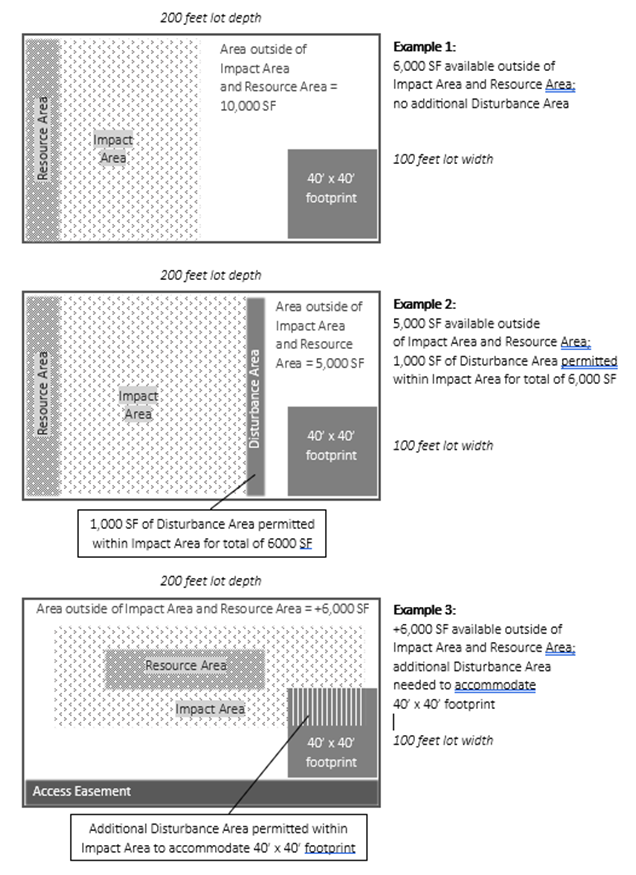
Except as specified in Subsection ii, the maximum development area (permanent and temporary) allowed within the Impact Area on a lot is determined by subtracting all portions of the lot outside the Resource Site and Impact Area from 6,000 square feet. This is calculated as follows:
ii.
Exception: If the application of this standard would preclude a 40-foot by 40-foot development footprint on the site, the maximum development area allowed within the Impact Area may be increased by the minimum area required to allow such a development footprint. The applicant may exclude the following areas from the development footprint: existing utility and access easements, floodplains, and land with slopes in excess of 25%.
Hypothetical examples of standards applied to a 20,000 SF lot (200 ft. by 100 ft.)
iii.
Of the 6,000 square feet maximum development area permitted, no more than 4,000 square feet shall be permanent development area. The balance may be temporary development area. Within the temporary development area, no trees 24 inches dbh or larger shall be removed.
iv.
Trees may be removed within the permanent development area. If any part of the Critical Root Zone of a 24-inch dbh or larger tree is within a proposed permanent development area, the entire Critical Root Zone of the tree shall be included for the purposes of calculating the maximum permanent development area.
2.
All other new or expanded development or redevelopment (except as listed in Subsections B—G and A.3), below, require an SNRP II and are subject to the SNRP II approval criteria in Section 12.80.130.G.
B.
Utility Expansion or Enlargement. Utility Expansion or Enlargement are subject to the general standards in Section 12.27.230. An SNRP I is required.
NOTE: For utility projects undertaken by utility providers across property that is not owned by the provider, the utility provider shall not be required to map or provide any information about the property except for the area within 50 feet on either side of the proposed development area of the utility's project.
C.
Public and Private Streets and Access. In addition to the general standards in Section 12.27.230, the following requirements apply to all regulated development activities involving new or expanded streets and access.
1.
Street and access projects which will be constructed at a location specified in an adopted City plan require an SNRP I.
2.
All other street and access expansion or enlargement projects require an SNRP II. The SNRP II approval criteria in Section 12.80.130.G. do not apply; however, the applicant must demonstrate that all of the following requirements are met:
a.
The street or access is necessary to provide access to the buildable area(s) of the property(ies) and is the minimum necessary within the SNR Site which allows safe passage by vehicles, bicycles and/or pedestrians.
b.
There is no other means of providing access, within the project boundaries or off-site through the use of easements, which does not affect an SNR Site or Impact Area.
c.
Where multiple properties require crossing an SNR Site for access, access has been consolidated into a single crossing by use of shared access easements, tracts, or dedication of public right-of-way.
d.
The location of the street or access does not preclude a future extension to buildable areas on adjacent properties.
D.
Outdoor recreation facilities. In addition to the general standards in Section 12.27.230, the following requirements apply to all regulated development activities involving new or expanded outdoor recreation facilities.
1.
New outdoor recreation facilities which meet all of the following standards require an SNRP I.
a.
The proposed trail, path, or enhancement is publicly owned or within a public easement and is implementing master planned park facilities or identified in the most recent City of Hillsboro Parks and Recreation System Plan.
b.
The proposed facilities are compatible with preserving natural resource functions: viewing shelters; benches; picnic tables; nature trails and interpretive signs, and similar uses and facilities.
c.
No trees 24-inch dbh or larger shall be removed. Dangerous Trees or invasive trees are exempt from this standard and may be removed.
2.
All other outdoor recreation facilities, including all proposals for high impact or facilities for active recreation such as athletic fields or courts; golf courses; and similar uses, require an SNRP II and are subject to the SNRP II approval criteria in Section 12.80.130.G.
E.
Removal of a Dangerous Tree(s) not in conjunction with other development. Except where noted otherwise, in addition to the general standards in Section 12.27.230, the following requirements apply to the removal of a Dangerous Tree (not in conjunction with other development). The removal of a Dangerous Tree(s) that meets all of the following standards requires an SNRP I and is exempt from the mitigation requirements of Section 12.27.240.
1.
An International Society of Arboriculture (ISA) basic tree risk assessment has been prepared by an ISA certified arborist.
2.
Removal of the tree is recommended by the qualified certified arborist, professional forester or landscape architect who has completed the basic tree risk assessment for the tree.
F.
Natural Resource Enhancement Plans and Projects. Except where noted otherwise, in addition to the general standards in Section 12.27.230, the following requirements apply to natural resource enhancement plans and projects.
1.
A natural resource enhancement plan or project that meets all of the following standards requires an SNRP I and is exempt from the mitigation requirements of Section 12.27.240.
a.
The proposal is for bank stabilization, riparian vegetation enhancement, in-channel habitat improvements, or similar activities which improve or maintain the quality of a SNR Site or its Impact Area.
b.
The quality of 1 or more ecological functions or values of the SNR will be improved.
c.
Plantings include only species from the CWS Native Plants List.
2.
All other natural resource enhancement plans and projects require an SNRP Type II and are subject to the SNRP II approval criteria in Section 12.80.130.G.
G.
Natural Resource Management Plans for Transportation Facilities. To protect public health and safety, airports and other public transportation facilities may require regulatory flexibility in addressing natural resource management issues. Public agencies responsible for transportation facilities (such as ODOT or the Port of Portland) may prepare and submit a Natural Resource Management Plan application for consideration by the Planning Commission.
1.
Through the Natural Resource Management Plan approval, the applicant may request approval for exceptions to the following requirements of this Code to the General Development Standards in Subsection 12.27.230.A. and the Compensatory Mitigation Standards in Section 12.27.240.
2.
Natural Resource Management Plans for Transportation Facilities require a SNRP III. The applicant must demonstrate that all of the following standards are met:
a.
The applicant is a public agency responsible for major transportation facilities.
b.
The applicant has submitted an Environmental Report prepared in accordance with Subsection 12.27.230.C.
c.
The Plan substantially conforms to the purposes of the SNRO zone.
d.
The Plan will improve the overall functions and values of the SNR sites within the Plan area.
(Ord. No. 6473, §§ 1, 2(Exh. A), 6-18-2024)
Editor's note— See editor's note to Sec. 12.27.200.
12.27.240 - Compensatory Mitigation Standards.
A.
When mitigation is required by other agencies.
1.
When mitigation is also required by the Corps, DSL and/or CWS, a copy of the mitigation plan prepared for those agencies shall be submitted to the Review Authority. The City shall not issue a development permit until all applicable Regional, State and Federal permit approvals have been granted.
2.
Wetland mitigation shall be provided per the functional and area replacement standards established by the Corps and the DSL. The SNRO shall not impose additional mitigation requirements for wetlands that exceed the mitigation ratios or functions required by federal and state law.
3.
Impacts to any SNR Site or Impact Area that are not within the boundaries of the jurisdictional wetland or a CWS vegetated corridor shall be mitigated pursuant to Subsection B, below.
B.
When mitigation is required by this section for adverse impacts to areas not otherwise regulated by other agencies the applicant shall provide compensatory replacement or enhancement mitigation according to Table 12.27.240-1 and the illustrative examples below, unless alternative mitigation is approved pursuant to Subsection C.
Example 1: mitigation of 600 sq. ft. development in a Level 3 SNR = either 900 sq. ft. replacement of Level 3 SNR; 1,800 sq. ft. of enhanced Level 3 SNR; or a combination of these two.
Example 2: mitigation of 1,200 sq. ft. development in an Impact Area = 1,200 sq. ft. enhanced Impact Area.
1.
Replacement Mitigation Areas shall be protected as Resource Areas when evaluating future development proposals.
2.
Replacement Impact Areas shall be contiguous to a resource area.
3.
Mitigation required by other agencies pursuant to Subsection A shall not count toward meeting the City of Hillsboro's mitigation requirements required by the Subsection B.
4.
All replacement or enhancement mitigation shall occur on-site and must be contiguous to the impacted resource. However, in no case shall mitigation required by this subsection be located within the CWS vegetated corridor. Public projects may complete mitigation off-site, but shall occur within the Urban Growth Boundary of Hillsboro.
5.
Within a replacement or enhancement mitigation area, trees shall be planted at a density at least 5 per 1,000 square feet Shrubs shall be planted at a density of at least 10 per 1,000 square feet Except for the number of trees and shrubs to be planted, mitigation plantings shall follow the re-vegetation standards in the CWS "Design and Construction Standards for Sanitary Sewer and Surface Water Management (R&O 19-5 as amended by R&O 19-22), Appendix A Planting Requirements." Existing native trees and shrubs, which will be retained within the mitigation area and which meet the minimum size and height of the planting requirements required for new plantings, may be counted toward meeting this requirement.
C.
Alternative Mitigation—Fee-in-lieu of Mitigation. At the applicant's request, as part of an SNRP II approval, the Review Authority may approve an alternative to the mitigation ratios and standards in Subsection B, above, as detailed below.
1.
The Review Authority may approve a fee-in-lieu of mitigation for all or a portion of the required mitigation if the applicant can demonstrate that it is not practicable to complete all or a portion of the mitigation on-site due to insufficient land area suitable for mitigation. Land area may be considered unsuitable for mitigation if it is developed or contaminated or has similar constraints, or if it has existing high quality resources that would not benefit from mitigation.
2.
The fee-in-lieu amount is set by Council resolution and shall be used for natural resource projects within the City at large.
(Ord. No. 6473, §§ 1, 2(Exh. A), 6-18-2024)
Editor's note— See editor's note to Sec. 12.27.200.
12.27.245 - Adjustments from Standards of Underlying Zoning.
The following adjustments and allowances are at the applicant's request. They may be approved by the Review Authority to accomplish the purposes of the SNRO and reduce negative impacts on the SNR Site.
A.
Applicability of the Development Standards. Requests for modifications to the applicable base zone standards for setbacks and lot coverage are reviewed as part of the applicable development application but may be noted in a SNRP application to demonstrate that impacts have been minimized to the extent feasible. Adjustments to the SNRO standards are not permitted.
B.
Lot Size Variation Permitted. As part of a land division, the Review Authority may approve reduction or enlargement of lot sizes below or above the base zone standards, provided that, on average, the entire site meets the base zone standards.
C.
Density calculation. The maximum density of the site shall include areas within the SNR not defined as undevelopable land in Section 12.01.500 under Acreage, Net. The minimum density may exclude SNR Areas at the applicant's option.
D.
SNR Site and Impact Areas Subtracted from Net Acreage. At the applicant's discretion, any SNR Site or Impact Area set aside as open space which exceeds the open space area required pursuant to Section 12.50.210 may be subtracted from net acreage used to calculate minimum residential density or floor area ratio.
1.
The additional open space shall be identified on the final plat as a separate permanent open space tract, with responsibility for maintenance specified as required in Subsection 3.
2.
If the approval of the development containing the additional open space does not include a final plat, the Review Authority shall condition the approval to require the applicant to record a separate conservation easement, identifying the additional open space area and assigning responsibility for maintenance specified as required in Subsection 3.
3.
Responsibility for maintenance and preservation of the conservation easement area or permanent open space tract(s) consistent with this section shall be specified in covenants, conditions and restrictions or other legal instrument subject to approval by the Planning Director and recorded with the final plat.
(Ord. No. 6473, §§ 1, 2(Exh. A), 6-18-2024)
Editor's note— See editor's note to Sec. 12.27.200.
12.27.250 - Boundary Verification and Modification.
A.
Boundary Verification—Impact Areas. As depicted on the Significant Natural Resources Overlay map, Impact Areas are measured adjacent to SNR sites as shown on Table 12.27.250-1. Applicants can choose to verify the boundary by either accepting the boundary location shown on the Significant Natural Resources Overlay map or updating the location based on Significant Natural Resource Impact Areas widths in Table 12.27.250-1 and the map correction criteria in Table 12.27.250-2. In all cases, when delineating the boundary of the impact area in the field, the edge of the impact area shall include the outer drip line of those trees where the tree trunk is wholly or partially within the boundary.
B.
Boundary Maintenance.
1.
SNR Site and Impact Area boundaries or resource level information shall be based on information obtained as part of site-specific studies, annexations to the City and other changes allowed by this Subchapter. Site specific delineation good for 5 years.
2.
Properties not previously inventoried by the City that may contain natural resources shall be inventoried by the City or the applicant/property owner prior to annexation and a significance determination made using the methodologies described in the adopted City of Hillsboro Goal 5 Natural Resources Inventory and Assessment Report. Natural resources determined to be significant and their Impact Areas shall be added to the SNRO as part of the rezoning process concurrent with annexation. An Economic, Social, Environmental and Energy (ESEE) Consequences Analysis shall be conducted for SNR Sites added to the SNRO using the methodology described in the adopted City of Hillsboro Economic, Social, Environmental and Energy Consequences Analyses Report to determine the SNRO level that will apply to the site: Level 1, 2, or 3; or Impact Area.
C.
Modification of Resource Site or Impact Area Boundaries.
1.
The boundaries or level of a SNR site or Impact Area may be modified as part of a SNRP approval to reflect new information from the site-specific study or to include new proposed mitigation areas. Modifications to boundaries of locally significant wetlands shall be based on a delineation subject to review and approval by the Department of State Lands.
2.
Map Corrections. All property owners who believe that the SNRO map is inaccurate in terms of either the boundary or level of SNR Site may file a correction request consistent with this subsection. Correction requests will be processed under the Type I or Type II permit procedure as specified in Table 12.27.250-1. The reasons for map corrections and correction criteria are specified in Table 12.27.265-2.
(Ord. No. 6473, §§ 1, 2(Exh. A), 6-18-2024)
Editor's note— See editor's note to Sec. 12.27.200.
12.27.300 - CRO Cultural Resource Overlay.
The Cultural Resource Overlay includes the following sections:
12.27.310 Purpose
12.27.320 Applicability and Boundary Delineation
12.27.330 Addition to the CRO
12.27.340 Removal from the CRO and Inventory
12.27.350 Routine Maintenance of Cultural Resource Structures
12.27.360 Minor Cultural Resource Alterations Permitted with Type II Approval
12.27.370 Major Cultural Resource Alterations Permitted with Type III Approval
12.27.380 Provision for Additional Open Space on Cultural Resource Sites
(Ord. 6401 § 1, 2022)
12.27.310 - Purpose.
The Cultural Resource Overlay zone (CRO) is established to identify and manage cultural resources, in order to:
A.
Promote public awareness and appreciation of the community's social, political, economic, and architectural and archaeological history, and advance civic pride and identity;
B.
Contribute to the community's economy and enhance local property values;
C.
Provide required protection for Cultural Resources: the provisions of this Subchapter meet Statewide Planning Goal 5 (ORS 197.015(8)) and OAR 660, Division 23 to inventory and protect Significant Cultural Resources according to specific procedures, standards and definitions. Cultural Resources are those sites designated as such on the Cultural Resource Inventory after designation pursuant to Section 12.27.320 below.
D.
Balance preservation with alternative land Uses. Standards in this Subchapter conserve and protect Cultural Resources while allowing reasonable economic use of property where adverse impacts to the resources can be mitigated.
E.
Evaluate development proposals. Standards in this Subchapter provide means to evaluate permitting development that affects Cultural Resources.
(Ord. 6401 § 1, 2022)
12.27.320 - Applicability and Boundary Delineation.
A.
Application. The Cultural Resource Overlay (CRO) applies to properties designated by City Council Resolution or Ordinance as Cultural Resources and regulated as Goal 5 resources. The list of designated Cultural Resources is referred to as the Cultural Resource Inventory Map. The CRO is also applied upon annexation to any site designated as a Cultural Resource on a Washington County Community Plan Map.
B.
Application within Conservation District. If a designated Cultural Resource site is located within a Conservation District, the more strict provisions of the Cultural Resource Overlay zone shall supersede the requirements of the Conservation District.
C.
Cultural Resource Designation Boundary.
1.
Unless otherwise specified, the boundary of a Cultural Resource site shall be the property lines of the lot on which the Resource is located. The boundary of the resource site may be modified through approval of a Major Cultural Resource Alteration pursuant to Section 12.27.360.
2.
Notwithstanding paragraph 1 above, the provisions of this section shall be applied only to the structures or features specifically included in the designation: structures or features not included in the designation are not subject to the provisions of this section.
D.
Unless otherwise specified, the boundary of a Cultural Resource site shall be the property lines of the lot on which the Resource is located. However, the provisions of this section shall be applied only to the structures or features specifically included in the designation: structures or features not included in the designation are not subject to the provisions of this section.
E.
Modification of Designation Boundary. Upon recommendation of the Historic Landmarks Advisory Committee, the Planning Commission may modify the boundary of a Cultural Resource designation to reflect removal of accessory structures or redevelopment of portions of the larger lot. Such modification shall be processed as a major CRA under Section 12.80.030.
F.
Compliance Required. No designated cultural resource in the CRO shall be altered, relocated or demolished without compliance with this Subchapter.
(Ord. 6401 § 1, 2022)
12.27.330 - Addition to the CRO.
A.
Additions. The Cultural Resource Overlay may be applied to properties upon application either by the property owner or by the City, under the provisions of this section.
1.
Addition to the CRO by the Property Owner. A property owner may nominate his or her property to the Cultural Resource Inventory by providing responses to the criteria in subsection D below to the Historic Landmarks Advisory Committee. The HLAC shall then review the nomination and adopt findings and a recommendation to the Planning Commission. The Planning Commission's recommendation shall be forwarded to the City Council for final designation.
2.
Addition to the CRO by the City. The Historic Landmarks Advisory Committee may nominate to the Cultural Resource Inventory any site within the City which is determined to have potential cultural significance, based on the criteria in subsection D below.
B.
Review by the HLAC, Planning Commission and City Council.
1.
Following consideration of an owner-initiated nomination as described in subsection A.1 above or the nomination and determination of potential cultural significance as described in paragraph A.2 above, the Historic Landmarks Advisory Committee shall forward its findings and recommendation to the Planning Commission.
2.
The Planning Commission shall receive the HLAC findings and recommendation, and shall review the nomination under the following process:
a.
In the case of an HLAC-initiated nomination, notification shall be sent by registered mail to the owner of record of the affected property as determined by the Washington County Tax Assessor. The notice shall include an explanation of the property owner's rights to refuse to consent to the application of the CRO pursuant to subsection C below, and the date, time and place of the Planning Commission public hearing as described in Subsection c, below;
b.
At least 20 days after mailing the notice to the property owner, the Planning Commission shall hold a public hearing on the nomination. Notice of the hearing shall be mailed in accordance with Type III notice procedures in Subsection 12.70.050.F. In addition, mailed notice shall also be provided to recognized local and County historical societies and to the State Historic Preservation Office.
c.
At the public hearing, the Planning Commission shall receive the findings and recommendation of the Historic Landmarks Advisory Committee, and shall review the nomination based on the criteria listed in subsection D. The Planning Commission shall also analyze the significance of the resource and the environmental, social, economic and energy consequences of allowing, limiting, or prohibiting Uses which would conflict with the Cultural Resource designation and its impact or conflicts with Uses allowed by the underlying base zone.
3.
Following its review and analysis, the Planning Commission shall make findings with respect to the criteria in subsection D, and shall provide a recommendation to the City Council concerning the proposed designation.
4.
The City Council shall consider the findings and recommendations of the HLAC and the Planning Commission and may by Ordinance apply the CRO to any site found to be culturally significant, thereby adding the site to the Cultural Resource Inventory.
C.
Owners' Ability to Decline Nomination. At any time prior to Council action on the nomination, the affected property owner or owners of record may refuse to consent to the application of the CRO and the addition of the site to the Cultural Resource Inventory. This refusal to consent shall be made in writing and filed with the Planning Director. The receipt of a refusal to consent shall remove the property from any continued consideration for application of the CRO or listing in the Cultural Resources Inventory.
D.
Criteria for Application of the CRO and Inclusion in the Cultural Resource Inventory. Sites nominated for application of the CRO shall be evaluated for cultural significance under the following criteria:
1.
The site is located within the City limits;
2.
The building, structure, site, or object is over 50 years of age or of exceptional importance;
3.
The site possesses sufficient historic integrity, meaning that there are no major alterations or additions that have obscured or destroyed the significant historic features. Major alterations that may destroy historic integrity include, but are not limited to, the following:
a.
Changes in pitch of the main roof;
b.
Enlargement or enclosure of windows on principal façades;
c.
Addition of upper stories or the removal of original upper stories;
d.
Covering the exterior walls with non-historic materials;
e.
Moving the resource from its original location to one that is dissimilar to the original; and/or
f.
Additions which significantly detract from or obscure the form and appearance of the historic resource when viewed from the public right-of-way.
4.
The site has historic significance as demonstrated by meeting at least 1 of the following criteria:
a.
Association with events that have made a significant contribution to the broad patterns of city, county, state, or national history; and/or
b.
Association with the lives or persons significant in our past; and/or
c.
Embody the distinctive characteristics of a type, period, or method of construction or that represent the work of a master, or that possess high artistic values, or that represent a significant and distinguishable entity whose components may lack individual distinction; and/or
d.
Have yielded, or may be likely to yield, information important in prehistory or history.
(Ord. 6401 § 1, 2022)
12.27.340 - Removal from the CRO and Inventory.
A.
Removal. The Cultural Resource Overlay may be removed from properties either by the property owner or by the City, under the provisions of this section. Removal of a property from the Overlay automatically removes the site from the Inventory.
B.
Objection to Listing by Original Owner. The property owner of record of a site listed on the Cultural Resources Inventory before September 1, 2000, may request removal of the site from the Inventory by submitting a written request to the Planning Director if that party still owns the property and filed an objection to the original listing of the property.
1.
The request shall specifically describe the site and shall include evidence documenting the formal objection of the property owner of record at the time the property was listed on the Cultural Resource Inventory.
2.
The Planning Director shall submit the request to the Planning Commission for adoption of a resolution acknowledging the request and forwarding the request to the City Council for approval. The Planning Commission shall not conduct a public hearing on the request, but may recommend that the City Council conduct a hearing.
3.
Upon receipt of the resolution of the Planning Commission, the City Council shall adopt a resolution removing the site from the Cultural Resources Inventory. The City Council may, but need not, conduct a public hearing on the request.
4.
The City Council may require that the site be documented in a manner consistent with accepted historic site documentation practices. The City shall not issue a permit for demolition or modification of a site subject to this subsection for at least 120 days from the date of the resolution removing the site from the Cultural Resources Inventory.
C.
Other Circumstances. In the absence of an objection to the initial listing, the property owner of record of a site in the CRO may also request removal of the CRO by submitting a written request to the City.
1.
The request shall cite the reasons why the property owner believes the site no longer qualifies as a designated cultural resource, based on the criteria listed in Subsection 12.27.330.D.
2.
The HLAC shall consider the request, based on the criteria in Subsection 12.27.330.D, and shall forward its findings and recommendation to the Planning Commission.
3.
The Planning Commission shall hold a public hearing on the request. Notice of the hearing shall be mailed in accordance with Type III notice procedures in Subsection 12.70.050.F. In addition, mailed notice shall be provided to recognized local and County historical societies, and to the State Historic Preservation Office.
4.
At the public hearing, the Planning Commission shall receive the findings and recommendation of the HLAC and any testimony submitted by interested parties.
5.
Following receipt of testimony, the Planning Commission shall deliberate and analyze the significance of the resource site and the environmental, social, economic and energy consequences of removing the Cultural Resource designation. Based on that analysis, the Planning Commission shall determine whether to approve or deny the request. A decision to approve the request shall be made as a recommendation to the City Council. A decision to deny the request shall be final unless appealed.
6.
The City Council shall receive and consider the recommendation from the Planning Commission to remove the CRO from the site, and may remove the CRO by ordinance. The Council may also choose to conduct its own public hearing on the recommendation.
7.
The City shall not issue a permit for demolition or modification of a site subject to this subsection for at least 120 days from the date of a resolution removing the site from the Cultural Resources Inventory.
D.
Removal Following Alteration, Relocation or Demolition. Following approval of an application to alter, relocate or demolish a designated cultural resource pursuant to Section 12.80.030 the HLAC may re-evaluate the site's conformance with the criteria in Subsection 12.27.320.D.
1.
If the HLAC finds that the site no longer conforms to the criteria in Subsection 12.27.320.D, the HLAC shall forward findings and a recommendation to the Planning Commission.
2.
Following receipt of the HLAC recommendation, the Planning Commission shall hold a public hearing on the proposed removal pursuant to paragraphs C.3 through C.5 above.
3.
The City Council shall receive and consider the recommendation from the Planning Commission to remove the CRO from the site, and may remove the CRO by ordinance. The Council may also choose to conduct its own public hearing on the recommendation.
E.
Removal Following Unintentional Demolition. If a Resource structure is damaged by accident, fire or natural disaster beyond the owner's control to the extent that it no longer retains the characteristics which made it eligible for the Cultural Resource Inventory, the Planning Director shall prepare an ordinance for Council approval to remove the site from the Cultural Resource Inventory.
(Ord. 6401 § 1, 2022)
12.27.350 - Routine Maintenance of Cultural Resource Structures.
A.
The following types of routine maintenance are permitted without a Cultural Resource Alteration approval, except as provided in subsection B, below:
1.
Repair or maintenance activities which do not affect the appearance of an architectural feature;
2.
Foundation repair or replacement, provided that the foundation material is similar to the original material and the new foundation does not raise or lower the building elevation;
3.
Repair and restoration using original or existing materials;
4.
Repair or replacement of deteriorated materials at the identical size, materials, and configuration as the original materials;
5.
Addition of fencing;
6.
Construction of detached accessory structures compliant with the following standards:
a.
The provisions of Section 12.40.104, regarding height, area, setbacks, and separation;
b.
Placement behind the rear building plane of the Resource structure; and
c.
Structural height, massing, and rooflines consistent with the Resource structure.
7.
Changes in landscaping newer than the resource structure, or addition of landscaping if there was none originally;
8.
Removal of any landscape feature which the Public Works Director deems a hazard to public safety.
B.
Routine maintenance as described in paragraphs A.1 through A.7 does not include major improvements such as replacement of siding, windows, or roofing throughout the structure.
(Ord. 6401 § 1, 2022; Ord. 6323 § 1, 2019)
12.27.360 - Minor Cultural Resource Alterations Permitted with Type II Approval.
A.
Alterations Permitted with Type II Approval. Except as provided under subsection B below, certain alterations may be permitted in the CRO upon approval of an administrative Minor Cultural Resource Alteration (CRA). The criteria for approval of a minor CRA are listed in Section 12.80.030. An application for a minor CRA shall be processed as a Type II procedure under the provisions of Section 12.70.040. The following alterations may be permitted upon approval of a Minor CRA:
1.
Alteration, relocation or demolition of an accessory building less than 50 years old, unless the site is on the National Register of Historic Places;
2.
Application of wood-framed storm windows;
3.
Removal of structural additions less than 50 years old, unless the site is on the National Register of Historic Places, or the structural addition is of exceptional significance;
4.
Structural or architectural feature additions to any designated structure if such addition or feature is not visible from the public right-of-way and the addition does not necessitate the removal of an original feature; and
5.
Demolition of any structure which the Building Official deems a dangerous building.
B.
The Planning Director may determine that an application for Minor Cultural Resource Alteration should be processed as a Type III procedure, based on the factors in Subsection 12.80.030.C.3.
C.
Negative Impacts Minimized. Under the provisions of Section 12.80.030, the Planning Director shall work with the applicant, interested citizens and technical staff to minimize the negative impact of the proposed action, wherever possible.
D.
Minor CRAs Reported to HLAC. The Planning Director shall provide a monthly report to the HLAC and the Planning Commission of all minor Cultural Resource Alteration applications and approvals.
(Ord. 6401 § 1, 2022)
12.27.370 - Major Cultural Resource Alterations Permitted with Type III Approval.
A.
Alterations Permitted with Type III Approval. The following alterations may be permitted in the CRO subject to the listed standards, upon approval of a quasi-judicial Major Cultural Resource Alteration. The criteria for approval of a major CRA are listed in Section 12.80.030. An application for a major CRA shall be processed as a Type III procedure under the provisions of Section 12.70.050.
1.
Demolition of a designated structure or removal of an original landscape feature, except a dangerous structure or landscape feature under Subsection 12.27.350.A.5;
2.
Relocation of a designated structure;
3.
Alteration, relocation or demolition of an accessory building over than 50 years old, or any accessory building on a site on the National Register of Historic Places;
4.
Removal of any original architectural feature or any feature over 50 years old;
5.
Structural or architectural feature additions to any designated structure if such addition or feature is visible from the public right-of-way and the addition necessitates the removal of an original feature; and
6.
Removal of any landscape feature if the landscape feature is comparable in age to the structure and is not deemed by the Building Official to be a hazard to public safety.
B.
Negative Impacts Minimized. The HLAC and the Planning Commission shall work with the applicant, interested citizens and technical staff to minimize the negative impact of the proposed action, wherever possible.
(Ord. 6401 § 1, 2022)
12.27.380 - Provision for Additional Open Space on Cultural Resource Sites.
A.
At the applicant's discretion, additional open space area may be set aside around designated Cultural Resource features upon development of a larger site. If set aside, the additional open space around the features may be subtracted from the net area of the development for purposes of residential density calculation.
B.
Additional open space so set aside shall be identified on the final plat (or final development plan if no land division is involved) as a conservation easement or a separate permanent open space tract.
C.
Responsibility for maintenance and preservation of such tracts or easements shall be specified in covenants, conditions, and restrictions or other legal instrument subject to approval by the Review Authority.
(Ord. 6401 § 1, 2022)
12.27.400 - ASCO Airport Safety and Compatibility Overlay. (Reserved)
[Section heading reserved]
12.27.500 - PUD Planned Unit Development Overlay.
The Planned Unit Development Overlay includes the following sections:
12.27.510 Purposes
12.27.520 Distinction from other Overlay Zones/Applicability
12.27.530 Administrative and Regulatory Coordination
12.27.540 Uses and Activities Permitted
12.27.550 Application and Process for PUD Approval
12.27.560 Modification of PUD Boundaries
(Ord. 6401 § 1, 2022)
12.27.510 - Purposes.
The Planned Unit Development (PUD) Overlay zone is established for the following purposes:
A.
To encourage flexibility, innovation, and diversity in location and design of structures and improvements consistent with the Comprehensive Plan, the applicable base zone(s), and applicable standards;
B.
To allow consideration of special Adjustments to Code standards within the context of the overall development project, thereby balancing the request for the Adjustments with desirable results that improve community livability;
C.
To allow more efficient site design for land uses, buildings, and circulation, energy, and utility systems;
D.
To preserve existing landscape features and natural resources, and better integrate such features and resources into site design;
E.
To provide usable and suitably sited public and common facilities;
F.
To provide greater compatibility with surrounding land uses than a project compliant with conventional zoning; and
G.
To allow simultaneous land divisions allowed through Subsections 12.80.096, 12.80.098, and/or 12.80.099, as applicable.
(Ord. 6401 § 1, 2022)
12.27.520 - Distinction from other Overlay Zones/Applicability.
A.
Distinction from Other Overlay Zones. The PUD overlay zone is unique, due to its creation as a result of an application from the property owner and a discretionary decision by the City, rather than as application as a response to existing site characteristics.
B.
Applicability. The PUD overlay may be applied on 1 or more properties of any size in any zone, upon application by the property owner and approval by the Review Authority. Development on the properties cited in Subsection 12.80.120.B. requires approval of a PUD overlay.
(Ord. 6401 § 1, 2022)
12.27.530 - Administrative and Regulatory Coordination.
The regulations of other agencies may apply to development proposals on properties within a PUD. The City will notify affected agencies of specific development proposals prior to the issuance of City permits. Applicants are encouraged to contact affected agencies before development plans are completed to determine requirements and restrictions that may be imposed by those agencies.
(Ord. 6401 § 1, 2022)
12.27.540 - Uses and Activities Permitted.
A.
Residential and Mixed-Use Zones. In residential and Mixed-Use zones, PUD concept plan approval allows development of a site with a mixture of Uses as listed in Subsection 12.80.120.C.1, subject to the density provisions of the underlying zone. Requests for additional density shall be considered under the provisions of Subsections 12.80.156 and 12.80.158.A.
B.
Commercial and Industrial Zones. In areas designated Commercial or Industrial on the Comprehensive Plan Map, PUD concept plan approval allows development of a site with Mixed-Uses subject to the limitations listed in Subsection 12.80.120.C.2.
C.
Regulations on Permitted Uses or Activities. In a PUD, use categories status or development standards of the underlying base zone may be modified or supplemented to accomplish the stated purpose of the PUD, as cited in Subsection 12.80.120.A.
(Ord. 6401 § 1, 2022)
12.27.550 - Application and Process for PUD Approval.
12.27.560 - Modification of PUD Boundaries.
See Section 12.80.100.
(Ord. 6401 § 1, 2022)
12.27.600 - SID Special Industrial District.
12.27.610 - Purpose.
The Special Industrial District (SID) is an overlay zone supplementing the provisions of the underlying I-P Industrial Park zone. The purposes of the Special Industrial District are:
A.
To protect and enhance development opportunities for industrial Uses which may require large sites in a planned campus industrial park setting;
B.
To provide opportunities for small- and medium-sized industrial Uses, compatible with planned campus industrial parks, to locate near large single user industrial Uses; and
C.
To preserve large lots for single major industrial Uses until such time as there is no demonstrated demand or need for such large lots.
(Ord. 6401 § 1, 2022)
12.27.620 - Applicability.
The SID overlay zone may be applied only on properties designated Industrial on the Comprehensive Plan Land Use Map, located within the following boundaries:
•
North Boundary: NW West Union Rd
•
South Boundary: NE Jacobson St
•
East Boundary: Western edge of the Burlington Northern Railroad right-of-way
•
West Boundary: Eastern edge of the Bonneville Power Administration easement
(Ord. 6401 § 1, 2022; Ord. 6294 § 1, 2019)
12.27.630 - Administration.
12.27.640 - Regulations on Permitted Uses or Activities.
A.
Exceptions to the Underlying Zoning.
1.
Development in the SID overlay zone shall conform to the base zone development standards of the I-P Industrial Park zone as contained in Section 12.25.200, except that the minimum lot size for development in the SID shall be 1 acre.
2.
Within the SID overlay zone, development and land division shall comply with the following standards:
a.
Lots of record < 5 acres. The minimum lot size for land divisions and development on lots of record 5 acres or smaller is 1 acre.
b.
Lots of Record < 30 acres. Except as provided in subsection D, contiguous lots of record in common ownership totaling between 5 and 30 acres shall be divided only in compliance with subsection B or C below.
B.
Reconfiguration of Contiguous Lots in One Ownership. New lots smaller than 30 acres may be created when all contiguous lots of record in common ownership meet all of the following requirements:
1.
The number of newly created lots is the same or fewer than the number of original lots;
2.
The newly created lots are configured to better allow aggregation than the original lots;
3.
The reconfiguration includes all contiguous lots of record in the common ownership;
4.
If the contiguous lots in common ownership total more than 30 acres, the proposed reconfiguration retains at least one 30-acre parcel. This 30-acre parcel may be further divided pursuant to subsection C below; and
5.
The reconfiguration shall be processed as a Type II application under the provisions of Section 12.70.040.
C.
Staged Development. Lots of record or contiguous lots of record in common ownership, which total more than 30 acres, may be divided into lots smaller than 30 acres subject to the following restrictions:
1.
No more than 20% of the total acreage may be divided into lots smaller than 30 acres, except under paragraphs 2, 3, and 4 below.
2.
After Development Review approvals pursuant to Section 12.80.040 or building permits have been issued on 60% of the lots or 60% of the total acreage, an additional 20% of the original land area may be divided into lots smaller than 30 acres.
3.
The staged land division described in paragraph 2 above may continue in 20% increments, provided that at least one 30-acre lot, suitable for a single major industrial use, remains undivided within the original lot or lots.
4.
The final 30-acre lot may be divided in accordance with this section only under a Type III subdivision application process pursuant to Section 12.80.098. To approve the final lot division, the Review Authority must find that the current supply of 30-acre or larger vacant lots in the SID, or in a County industrial zone with substantially similar land division restrictions, is adequate to supply the present and projected county-wide demand for large lots if the final lot is divided.
5.
Upon compliance with paragraphs 1 through 4 above, division of the final 30-acre lot is not subject to the requirements of this section.
D.
Exceptions to Lot Division Requirements.
1.
Transportation Plan Implementation. Lots of record or contiguous lots of record in common ownership larger than 30 acres may be reconfigured or divided into smaller lots to the extent necessary to allow the dedication and/or construction of public Collector or Arterial roadways to implement Comprehensive Plan Section 20 Transportation and the adopted Transportation System Plan cited in Comprehensive Plan Section 23.
2.
Natural and Hazard Areas. Lots of record or contiguous lots of record in common ownership larger than 30 acres may be reconfigured or divided into smaller lots to accommodate the following conditions:
a.
The presence of a natural division of the lot(s) by a significant natural resource area, flood hazard area or other resource or hazard designation in which standards may restrict development under Subsection 12.27.100 or 12.27.200; or
b.
The intent to divide the lot(s) to provide for separate common or public ownership of natural areas, flood hazard areas or other natural resource or hazard areas within an industrial park.
3.
Division of Remaining Lots. Smaller lots remaining after the reconfiguration or division of a larger lot or lots of record remain eligible for further reconfiguration or division pursuant to subsections B and C above. In calculating the land area involved in a subsequent reconfiguration or land division, the land area of the original lots at the time of annexation shall be used.
(Ord. 6401 § 1, 2022; Ord. 6250 § 1, 2017)
12.27.650 - Establishment or Modification of Overlay Boundaries.
The boundaries of the SID overlay zone as described in Section 12.27.620 are not subject to modification.
(Ord. 6401 § 1, 2022)