
Hillsboro City Zoning Code
SUB CHAPTER 12.50
DEVELOPMENT AND DESIGN STANDARDS
12.50.010 - Purpose.
The development and design standards in this subchapter are intended to ensure project design and construction which:
A.
Includes adequate, structurally sound public and private streets and utilities;
B.
Allows logical, efficient development or redevelopment of adjacent properties;
C.
Includes a range of lot sizes, structural design, setbacks, and housing choices;
D.
Respects surrounding context and enhances community character;
E.
Considers security and privacy;
F.
Provides attractive usable open space in functional locations;
G.
Provides adequately for community infrastructure such as utilities, vehicle, bicycle and pedestrian transportation, schools, parks and other public requirements; and
H.
In general, promotes public health, safety, convenience, and general welfare.
(Ord. 6401 § 1, 2022; Ord. 6322 § 1, 2019)
12.50.020 - Organization and Hierarchy of Standards and Guidelines.
Development activities subject to this subchapter are also subject to the base zone standards in Subchapters 12.21 through 12.26, the special use standards in Subchapter 12.40, and any applicable overlay zone standards or plan district standards in Subchapters 12.27 or 12.60 through 12.67. Where development and design standards conflict with other standards in this Code, refer to Section 12.01.430 for the hierarchy of standards.
(Ord. 6401 § 1, 2022; Ord. 6322 § 1, 2019)
12.50.030 - General Applicability.
A.
Except as modified under subsection B below or exempt under subsection C below, the standards of Subchapter 12.50 apply to all properties and development activities within the City limits. Each standard includes specific applicability provisions which may modify the general applicability, and individual standards may not apply to some development projects. Each standard may also include exceptions specific to that standard. Applicability of standards will be determined through a Type I, Type II, or Type III application process an alternative review procedure described in Section 12.70.025, or during review of major site alterations or other construction as defined in Section 12.01.500.
B.
Non-conforming Uses, Structures or Lots. The development standards and design guidelines in this subchapter may be applied differently to non-conforming uses, structures or lots, as specified in Subchapter 12.30.
C.
Exemptions. The following types of development are exempt from compliance with the standards of this subchapter:
1.
Ordinary maintenance or repair of an existing building or structure;
2.
Interior remodeling or external alteration of an existing building or structure which meets any of the following thresholds:
a.
No substantial changes to exterior appearance from a public or private street or from a public accessway; or
b.
No change of housing type from single detached dwelling or middle housing to multi-dwelling, or
c.
No change of use type from residential to commercial, industrial, or institutional; or
d.
No requirement for approval through the Development Review process due to the location of the site in a particular zone, plan district, or overlay zone.
3.
Building and/or site alterations required to comply with the Americans with Disabilities Act (ADA); or
4.
Non-structural "minor site alterations" meeting the following standards:
a.
Five hundred square feet or less ground area disturbance due to grading or paving;
b.
No resulting effect on site access, site topography, mature or specimen trees, natural resources, or required landscaping; or
c.
No resulting alteration of on-site drainage pattern at a property line.
(Ord. 6401 § 1, 2022; Ord. 6322 § 1, 2019; Ord. 6178 § 1, 2016)
12.50.100 - General Lot Standards.
12.50.110 - Lot Dimensions.
A.
Lot Area.
1.
Lot area is defined in Section 12.01.500 under Lot Dimensions.
2.
Lots created after September 4, 2014 must contain the minimum lot area specified within the standards of the applicable zone, unless variations are approved by the Review Authority pursuant to paragraph 3 of this subsection A, or unless a Variance or Adjustment has been granted by the Review Authority pursuant to Section 12.80.150.
3.
Lot Area Exception for Middle Housing.
a.
Within middle housing zones, exceptions to the minimum lot area standards in the applicable base zone may be approved through a middle housing land division, provided that the lot area of the parent lot meets the minimum requirement of the base zone.
b.
Within all zones, exceptions to the minimum lot area standards in the applicable base zone may be approved by the Review Authority for duplex or townhouse development to allow division of parent lots into child lots, as defined in Section 12.01.500, provided that the lot area of the parent lot meets the minimum requirement of the base zone.
B.
Lot Depth.
1.
Lot depth is defined in Section 12.01.500 under Lot Dimensions.
2.
Figure 12.50.110-A illustrates methods to measure lot depth on regular lots, irregular lots, flag lots, and corner lots.
3.
Lots created after September 4, 2014 must have the minimum lot depth specified within the standards of the applicable zone, unless variations are approved by the Review Authority pursuant to paragraph 4 below, or unless a Variance or Adjustment has been granted by the Review Authority pursuant to Section 12.80.150.
Figure 12.50.110-A:
Examples of Measuring Lot Depth on Various Lot Types
4.
Lot Depth Exception for Middle Housing.
a.
Within middle housing zones, exceptions to the minimum lot depth standards in the applicable base zone may be approved through a middle housing land division, provided that the lot depth of the parent lot meets the minimum requirement of the base zone.
b.
Within all zones, exceptions to the minimum lot depth standards in the applicable base zone may be approved by the Review Authority for duplex or townhouse development to allow division of parent lots into child lots, as defined in Section 12.01.500, provided that the lot depth of the parent lot meets the minimum requirement of the base zone.
C.
Lot Width.
1.
Lot width is defined in Section 12.01.500.
2.
Figure 12.50.110-B illustrates methods to measure lot width on regular lots, irregular lots, flag lots, and corner lots.
3.
Lots, parcels or tracts created after September 4, 2014 must have the minimum lot width specified within the standards of the applicable zone, unless variations are approved by the Review Authority pursuant to paragraph 4 below, or unless a variance or an adjustment has been granted by the Review Authority pursuant to Section 12.80.150.
Figure 12.50.110-B:
Examples of Measuring Lot Width on Various Lot Types
4.
Lot Width Exception for Middle Housing.
a.
Within middle housing zones, exceptions to the minimum lot width standards in the applicable base zone may be approved through a middle housing land division, provided that the lot width of the parent lot meets the minimum requirement of the base zone.
b.
Within all zones, exceptions to the minimum lot width standards in the applicable base zone may be approved by the Review Authority for duplex or townhouse development to allow division of parent lots into child lots, as defined in Section 12.01.500, provided that the lot width of the parent lot meets the minimum requirements of the base zone.
D.
Lot Frontage.
1.
Lot frontage is defined in Section 12.01.500 under Frontage.
2.
Figure 12.50.110-C illustrates methods to measure lot frontage on regular lots, irregular lots, and flag lots.
3.
Except for child lots created through a middle housing land division, lots created after September 4, 2014 must have the minimum lot frontage specified within the standards of the applicable zone, unless a Variance or Adjustment has been granted by the Review Authority pursuant to Section 12.80.150. In zones where flag lots are permitted, lot frontage may be reduced on adjacent flag lots pursuant to paragraph 5 below.
Figure 12.50.110-C:
Examples of Measuring Lot Frontage on Various Lot Types
4.
Property abutting the end of a public or private street not ending in a cul-de-sac, or which may be subject to future extension, shall not be considered as having lot frontage.
5.
Minimum lot frontages may be reduced below base zone standards for flag lots as described in Section 12.40.160.
E.
Lot Coverage.
1.
Lot coverage is defined in Section 12.01.500 under Lot Dimensions.
2.
Lot coverage is calculated by totaling the area(s) of all building footprints on the lot, parcel or tract, excluding buildings 24 inches or shorter above native grade, and dividing the total footprint area into the area of the lot, parcel or tract. Figure 12.50.110-D illustrates an example of lot coverage measurement.
3.
Except for child lots created through a middle housing land division, development on any lot after September 4, 2014 shall not be approved if the additional building footprint on the lot, parcel or tract would result in a lot coverage percentage exceeding the maximum specified within the standards of the applicable zone, unless a Variance or Adjustment has been granted by the Review Authority pursuant to Section 12.80.150 or Section 12.80.120.
Figure 12.50.110-D:
Example of Lot Coverage Measurement
(Ord. 6465 § 2, 2024; Ord. 6401 § 1, 2022; Ord. 6178 § 1, 2016; Ord. 6120 § 1, 2015)
12.50.120 - Residential Density.
A.
Definition and Purpose. Residential density is defined in Section 12.01.500. Establishing minimum and maximum densities creates consistency within neighborhoods, achieves planned intensities of residential development and encourages development parameters within which the market will operate to provide particular housing types. Establishing maximum densities also ensure that the intensity of residential development will match the availability of public services.
B.
Standards and Calculation Methodology.
1.
Unless specified otherwise in paragraph 2 or 3 below, residential density in development projects containing residential dwellings submitted after September 4, 2014 must be between the minimum and the maximum residential density of the applicable zone, unless a Variance or Adjustment has been granted by the Review Authority pursuant to Section 12.80.120 or 12.80.150.
2.
Unless specified otherwise in the base zone standards, the minimum residential density is 80% of the maximum density permitted by the base zone applicable on a site. The minimum or maximum number of dwellings permitted for a project is calculated by multiplying the minimum or maximum density standard by the net residential acres within the development site.
3.
Residential density in group living, residential service uses is calculated at 4 residents equivalent to 1 dwelling unit.
4.
In multi-dwelling residential developments, dwelling units with 4 or more bedrooms may be calculated as 2 dwelling units at the applicant's discretion. If provided, dwelling units with 4 or more bedrooms shall be limited to a maximum of 20% of the total dwelling units.
5.
Unless otherwise specified in the applicable zone, minimum and maximum density calculations do not include accessory dwelling units.
C.
Exceptions to Minimum Density.
1.
On lots larger than 12,000 square feet designated Medium, High, or Mid-Rise Density Residential on the Comprehensive Plan Map, building permit applications for a single detached dwelling shall be approved only upon demonstration by the applicant that the dwelling is sited to allow further development of the remainder of the lot at the minimum density permitted under the implementing zone of the Comprehensive Plan designation.
2.
One or more dwellings may be constructed on an existing lot of record in a light rail residential zone if the dwelling(s) is/are sited to allow future development of the remainder of the lot to at least the minimum applicable density without demolishing the new dwelling(s).
3.
On a site containing existing mature or specimen trees as defined in Section 12.50.230, net acreage on a development site may be reduced by subtracting the area within the drip line of the trees, up to a maximum reduction of 35% of the original net acreage. Applications proposing net acreage reductions to preserve existing trees shall include a certified arborist's report and tree preservation plan. The approval of the development may be conditioned by the Review Authority on implementation of the recommended tree preservation measures.
4.
Pursuant to Section 12.27.230, on sites within or partially within a Significant Natural Resource (SNR) area, the Review Authority may limit residential density on portions of the SNR area below the minimum density specified in the base zone and may allow transfer of such density to the portion of the site outside the SNR area.
D.
Exceptions to Maximum Density.
1.
Pursuant to Section 12.80.156, increased residential density above the specified maximum of the base zone may be approved as a Major Adjustment in conjunction with a Planned Unit Development Concept Plan application. Such density increases shall be limited to 120% of the maximum of the underlying base zone density.
2.
Pursuant to Section 12.27.200, on sites within or partially within the Significant Natural Resource Overlay (SNRO) zone containing otherwise developable land, overall residential density on the site may be limited by the Review Authority to 50% of the maximum permitted by the base zone, to protect the SNRO area. The Review Authority may approve transfer of a portion of the otherwise allowable density to the remainder of the site outside the SNRO area. Such density transfer shall be limited as follows:
a.
Not more than 30% of the maximum number of units allowed in the SNRO area may be transferred; and
b.
The resulting density on the remainder of the site shall not exceed 80% of the allowed maximum number of units.
(Ord. 6401 § 1, 2022; Ord. 6323 § 1, 2019; Ord. 6322 § 1, 2019; Ord. 6294 § 1, 2019; Ord. 6120 § 1, 2015)
12.50.130 - Setbacks.
A.
Definition and Purpose. Setbacks (also known as "yards") are defined in Section 12.01.500. Minimum setback standards are intended to provide light and air between buildings and protection to neighboring properties. Maximum setback standards are intended to complement applicable standards for building height, floor area ratio, and design to promote an attractive streetscape and pleasant pedestrian environment in higher density neighborhoods. Maximum setbacks are not applicable in all zones. Minimum and maximum setback standards apply to all structures and portions of structures more than 24 inches above grade.
B.
Measurement Methodology: Minimum Setbacks. Figures 12.50.130-A, 12.50.130-B, and 12.50.130-C illustrate the methods to measure minimum front, interior, side and rear setbacks on interior lots, corner lots, irregular lots and flag lots.
Figure 12.50.130-A:
Examples of Measuring Minimum Setbacks on Various Lot Types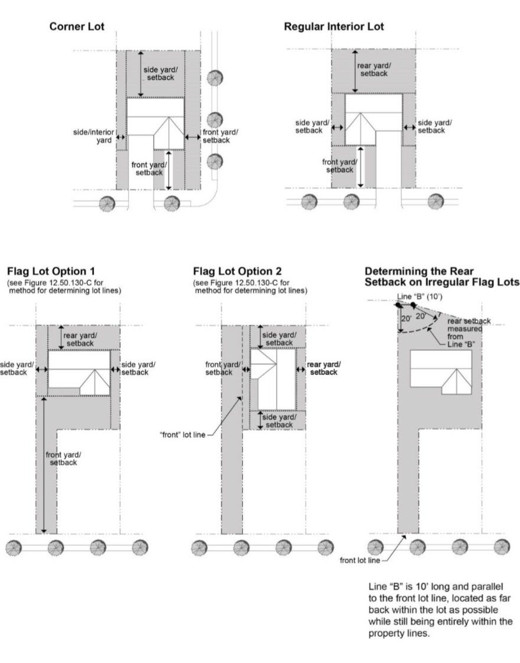
Figure 12.50.130-B:
Measuring Minimum Front, Interior, Side and Rear Setbacks on Irregular Lots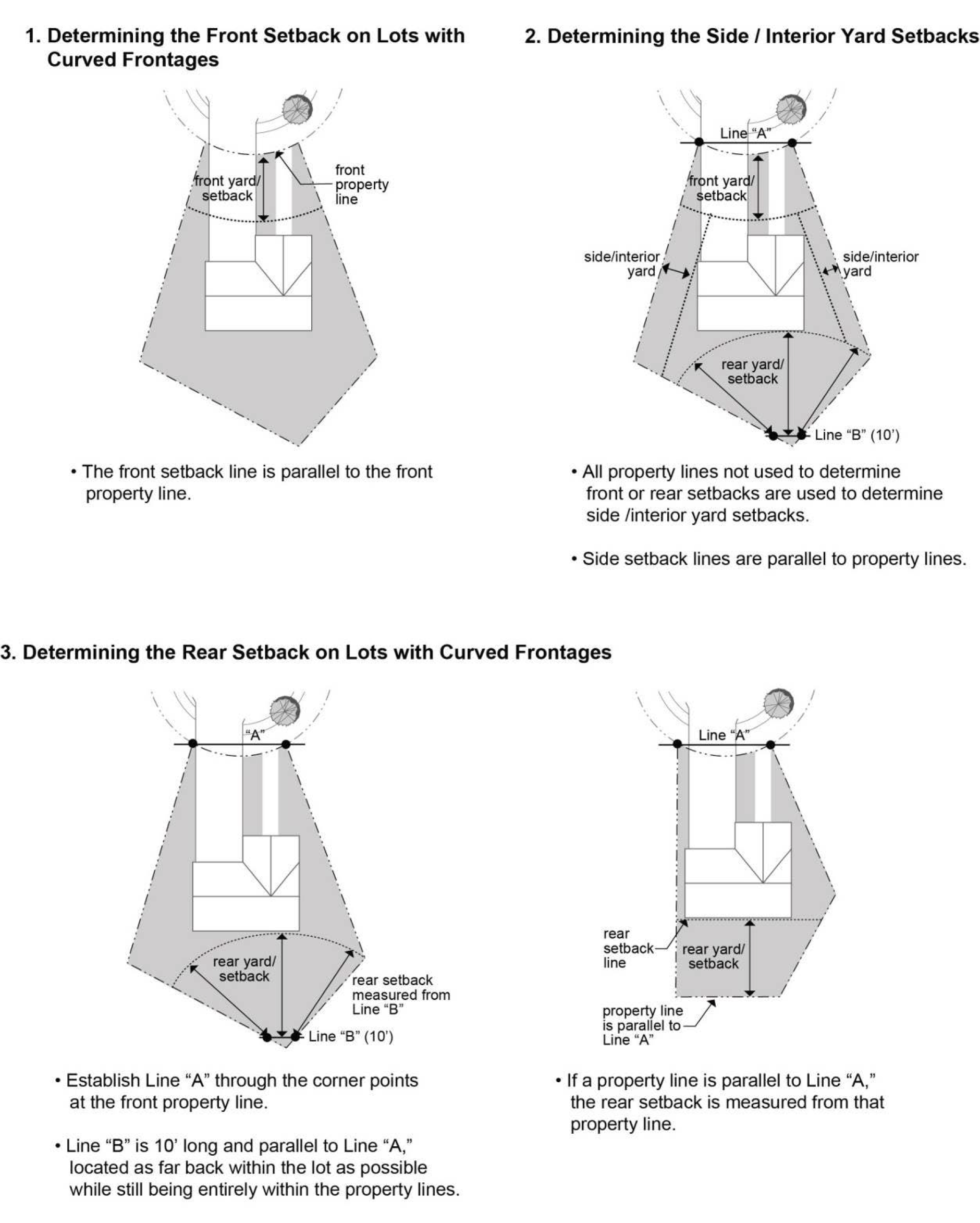
Figure 12.50.130-C:
Measuring Minimum Setbacks on Flag Lots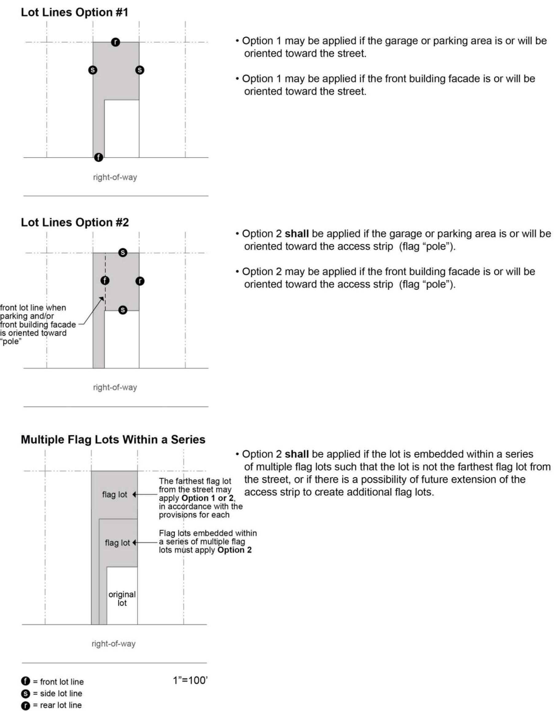
C.
Measurement Methodology: Maximum Setbacks.
1.
Figure 12.50.130-D illustrates the methods to measure maximum front setbacks for residential and non-residential buildings.
Figure 12.50.130-D:
Measuring Maximum Front Setbacks
Single Detached Dwellings and Middle Housing
Commercial, Industrial, Institutional, Multi-Dwelling or Mixed-Use Buildings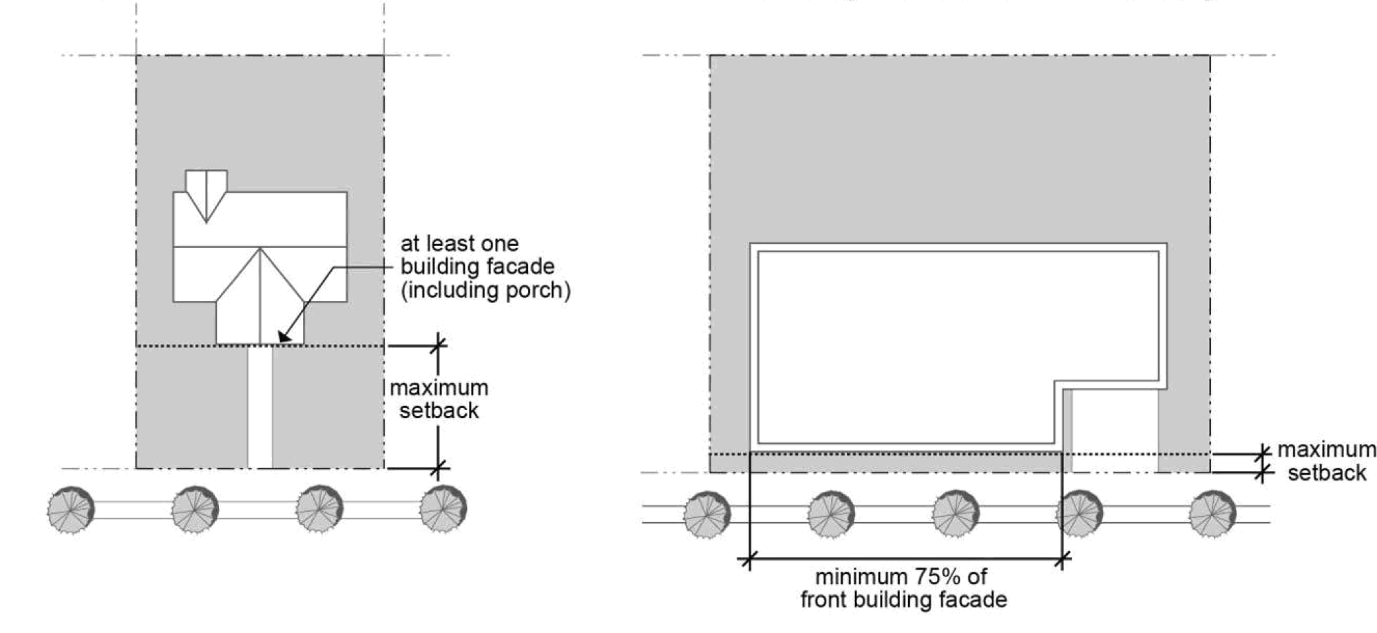
2.
Garage and Carport Setbacks.
a.
In General. Setbacks measured to a garage door shall also be applicable to the entrance of a carport. The setback distance shall be measured to the support posts of the carport closest to the driveway, or to the edge of the carport roof if there are no posts.
b.
In Light Rail Zones. Figure 12.50.130-E illustrates the methods to measure garage setbacks in light rail zones, where a residential garage or carport is accessed from a street or a public alley, the setback to the garage door or carport opening shall be either equal to the dwelling unit setback (if that setback is 5 feet or less) or 19 feet or greater, except:
i.
If the dwelling unit setback is more than 19 feet, the setback to the garage/carport shall equal or exceed the dwelling unit setback; or
ii.
If the garage door or carport opening is perpendicular to the front property line, then the garage/carport setback shall be equal to or greater than the dwelling.
Figure 12.50.130-E:
Measuring Garage Setbacks in Light Rail Zones
3.
Maximum Setback Compliance. In zones where maximum setbacks apply, the maximum setback standard is considered met under the following circumstances:
a.
For single detached dwellings and middle housing, where at least 1 façade, including a porch, is located no farther from the property line than the setback specified for the zone; or
b.
For commercial, industrial, institutional, multi-dwelling, or Mixed-Use buildings, where at least 75% of the front building façade is located no farther from the property line or future right-of-way line than the maximum setback specified for the zone.
4.
Build-To Zone. In the urban center zones, maximum front setbacks may be expressed as build-to zones.
D.
Standards.
1.
Structures built on lots after September 4, 2014 must meet the minimum and maximum (if applicable) setback standards of the applicable base zone, unless a variation is approved by the Review Authority pursuant to subsection E below or unless a Variance or Adjustment has been granted by the Review Authority pursuant to Section 12.80.150. In the case of middle housing land divisions, setback standards apply to the parent lot, but not the child lot.
2.
Where public or private utility easements are present on a lot, the setback may include the easement. However, setbacks are subordinate to such easements if the easement is wider than the required setback. Setbacks may be increased by the Review Authority above either the minimum or maximum standards of the base zone to accommodate such easements, and to provide necessary angles of repose as required by the Building Code.
3.
Setbacks measured to a garage door shall also be applicable to the entrance of a carport. The setback distance shall be measured to the support posts of the carport closest to the driveway, or to the edge of the carport roof if there are no support posts.
E.
Front Yard Setback Variations.
1.
Purpose. Front yard setback variation provisions are intended to provide opportunity for a wider range of structural design, setbacks, and housing choices within new development, and provide developers with flexibility in response to varying site conditions.
2.
Applicability.
a.
These standards may be applied to single detached and middle housing residential subdivisions or single detached and middle housing residential PUDs with 8 or more lots.
b.
Front yard setback variations may not be applied if a Minor or Major Adjustment for front yard setback variations has also been requested or approved.
c.
Pursuant to Section 12.50.020, the standards of this section are subordinate to more specific standards of any applicable plan district.
3.
Standards.
a.
Up to 20% of the houses in the subdivision or PUD may have front yard setbacks greater or less than the applicable base zone standard, by at least 1-foot variation. Setback variations may not be reduced below 80%, or increased above 120%, of the required minimum setback. Application of this reduction is further restricted as follows:
i.
The varied setback applies only to the residence portion of the structure;
ii.
Front setbacks on corner lots where reduced setbacks are already allowed on 1 street cannot be further reduced;
b.
Front yard setbacks shall not be reduced if the setback contains a public utility easement wider than the proposed reduced setback and the necessary angle of repose as required by the Building Code.
F.
Exemptions.
1.
First-Story Decks. For purposes of this Code, first-story decks may be located within required side, rear, and interior setbacks if such decks meet the following standards:
a.
The outside edge of the deck is at least 3 feet from the side, rear, and interior property lines;
b.
The deck does not exceed the height of the first-story finished floor of the associated building, or 24 inches, whichever is less, as measured from the natural grade to the finished deck surface; and
c.
The deck surfaces and ground surfaces beneath the deck are both permeable.
2.
Soundwalls and Ramps. For purposes of this Code the following are not considered structures for the purposes of determining setbacks:
a.
Sound walls installed according to a plan approved by the City as part of a land use application;
b.
Accessibility ramps.
3.
Publicly-Owned Parks. In publicly-owned parks, expansion of existing accessory structures or recreational facilities and construction of new accessory structures or recreational facilities are exempt from the minimum and maximum setback standards of the applicable base zone. Accessory structures in public parks and recreational facilities may include, but are not limited to: restrooms, weather shelters, equipment storage buildings, and similar structures.
4.
Basement Window Egress Wells. For the purposes of this Code, basement window egress wells may be located within required side, rear, and interior setbacks.
G.
Exceptions for non-conforming Structures. Pursuant to Section 12.30.600, existing structures with non-conforming setbacks may be altered if the alteration does not increase the deviation from the setback standard of the applicable base zone. Setbacks for additions to non-conforming structures in light rail zones are subject to the provisions of Section 12.30.600.
H.
Exceptions to Minimum Setbacks. The Review Authority may approve exceptions to a minimum setback standard under any of the following circumstances without a Variance or an Adjustment:
1.
Side Yard Setback Reductions for Structural Building Elements. Side yard setbacks in all zones may be reduced to allow structural building elements not containing usable or habitable floor area. Such elements may include, but are not limited to, bay windows, alcoves, or cantilevered closets. Structural building elements may extend up to 4 feet into the required setback, provided that:
a.
A minimum 3-foot setback is provided from the projection to the property line;
b.
Structural building elements on adjacent structures are not aligned opposite one another;
c.
The total length of any structural building element(s) is/are not more than 25% of the length of the wall from which they project;
d.
Side yard setbacks shall not be reduced if the setback contains a public utility easement wider than the proposed reduced setback and the necessary angle of repose.
2.
Accessory Structures. In a residential zone, side and rear setbacks may be reduced to 3 feet for an accessory structure which meets the standards of Subsection 12.40.104.B.
3.
Accessory Dwelling Units. Side and rear setbacks may be reduced for detached accessory dwelling units that meet the standards of Subsection 12.40.100.D.7.
4.
Townhouse Divisions. In a residential zone, side setbacks may be reduced to zero feet for the interior lots of approved duplex or townhouse partitions, subdivisions, or middle housing land divisions.
5.
Non-Structural Architectural Features Projecting into Setbacks. Except as provided in paragraphs a and b below, non-structural architectural features can project up to 2 feet into a required setback. Examples of such features include, but are not limited to, cornices, eaves, canopies, sunshades, gutters, chimneys, flues, belt courses, leaders, sills, pilasters, and lintels.
a.
Non-structural architectural features on a dwelling unit cannot project more than 4 feet into a required front or rear setback in single detached and middle housing residential zones, or 3 feet into required side yards.
b.
Non-structural architectural features on accessory structures having reduced setbacks under paragraph 1 above may not extend closer than 3 feet from any property line.
c.
Non-structural architectural features may not project more than 2 feet into the required yards in any non-residential zone.
6.
Front or Rear Yard Setback Reductions for Structural Building Elements. In Mixed-Use zones only, structural building elements such as porches, decks, pergolas, balconies, and stoops may encroach by no more than 4 feet into a required front or rear setback, subject to compliance with applicable standards of the Oregon Structural Specialty Code and Oregon Fire Code and accommodation of public utility easements.
7.
Projections into Public Right-of-Way. Second story bay windows, balconies, awnings, and canopies may extend into public right-of-way upon approval by the City Engineer, Building Official, and Fire Marshal.
I.
Exceptions to Maximum Setbacks. The Review Authority may approve exceptions to a maximum setback standard without a Variance or an Adjustment under any of the following circumstances:
1.
Where a Public Utility Easement (PUE) is wider than the maximum setback of the applicable base zone, the structure shall be set back to accommodate the PUE and the necessary angle of repose.
2.
In mixed-use or non-residential developments, maximum front setbacks may be exceeded by up to 10 additional feet if the Review Authority finds that all of the additional setback would be used to provide enhanced pedestrian amenities such as plazas, arcades, courtyards, or other such usable pedestrian space.
3.
In residential development in light rail zones, on irregular lots on curvilinear streets or culs-de-sac, increases in maximum setbacks may be granted subject to the following standards:
a.
For dwellings, the front setback is the minimum necessary to achieve either of the following at the front building plane: a 25-foot lot width for a townhouse; or a 48-foot lot width for a detached dwelling;
b.
The increased setback is applied to 5 or fewer individual lots in a land division subject to a Type II procedure or 10 or fewer lots in a land division subject to a Type III procedure;
c.
The residential density required by the base zone is met; and
d.
The increased setback meets the standards in paragraph 6 below.
4.
To allow location of a structure where the site is located:
a.
In an existing development where the required maximum setback would be inconsistent with previous development on the surrounding properties; or
b.
In an existing development where private legal restrictions require a setback greater than the maximum standard of the base zone; or
c.
At the entry of a development, where planned entry features would be precluded by conformance with the maximum setback standard; and
d.
The increased setback meets the standards in Section 12.80.158.
5.
To accommodate placement of surface parking, maneuvering or loading areas or service docks on corner lots, if the parking, maneuvering or loading areas meet the standards in Sections 12.50.350 and 12.50.360.
J.
Increased Setbacks Adjacent to Substandard Right-of-Way.
1.
Setbacks Adjacent to Substandard Alleys. Adjacent to an alley right-of-way less than 20 feet in width, the setback from the centerline of the alley shall be a minimum of 10 feet, to maintain a 20-foot wide emergency fire access corridor free of obstructions. An additional setback from an alley may be required by the Fire Marshal if necessary to accommodate larger firefighting equipment.
2.
Additional Setbacks to Accommodate Street Widening. To accommodate street improvements and right-of-way dedications in compliance with the Transportation System Plan (TSP), additional setbacks beyond the minimum standards in the base zones shall be required on the streets identified in Table 12.50.130-1. On streets identified in Table 12.50.130-1, the front setback shall be increased by the distance specified, measured from the center of the street right-of-way. This distance represents the eventual right-of-way width as specified in the TSP.
(Ord. 6451 § 1, 2023; Ord. 6401 § 1, 2022; Ord. 6393 § 1, 2021; Ord. 6323 § 1, 2019; Ord. 6322 § 1, 2019; Ord. 6294 § 1, 2019; Ord. 6178 § 1, 2016; Ord. 6120 § 1, 2015)
12.50.140 - Building Height.
A.
Definition and Purposes. Building height is defined in Section 12.01.500. Minimum and maximum building height standards promote relationship of scale among structures in residential, commercial, and industrial neighborhoods, helping to create harmonious environments which enhance a sense of place. Variations in maximum building height among zones allow increased intensity of development in light rail, Mixed-Use and Urban Center zones.
B.
Standards and Measurement Methodology.
1.
Standards. Except as provided under subsections C and D below, structures built after September 4, 2014 must comply with the maximum (and minimum if applicable) building height standards of the applicable base zone, unless a Variance or Adjustment has been granted by the Review Authority pursuant to Section 12.80.150.
2.
Figure 12.50.140-A illustrates the methods to measure building heights for buildings with flat roofs, mansard roof, and pitch or hip roofs. Except as provided under paragraph 4 below, building height is measured from finished grade at the center of the front building plane.
Figure 12.50.140-A:
Measuring Building Height on Various Roof Types
3.
Minimum and maximum building height in light rail, Mixed-Use, and non-residential standard zones is calculated in feet, to the points shown in Figure 12.50.140-A.
4.
Figure 12.50.140-B illustrates the method to measure building heights for buildings on slopes. Except as provided under paragraph 5 below, building height is measured from finished grade at the center of the front building plane.
Figure 12.50.140-B:
Measuring Building Height on Slopes
5.
If a difference of 6 feet or more exists between the elevations at finished grade of the front and rear building planes, building height shall be measured from the center of the side walls between the front and rear building planes.
6.
Minimum and maximum building height in single dwelling and multi-dwelling residential zones is calculated in stories, as shown in Figure 12.50.140-C below. In calculating minimum and maximum height in stories, a residential "story" is considered to be not more than 10 feet.
7.
Figure 12.50.140-C illustrates measurement of building height in stories related to basements and top stories. As illustrated, a basement is not a story if its finished floor is at least 6 feet below finished grade at the mid-point of the wall.
Figure 12.50.140-C:
Measuring Building Height in Relation to Basements and Top Stories
C.
Building Height Transition in Mixed-Use Zones. Building heights for new development in the MU-N and MU-C zones shall "step-down" and provide for a transition where adjacent to existing single detached and middle housing residential zoning to provide compatible scale and privacy between developments.
1.
Building height transitions shall be applied to new and vertically expanded buildings in the MU-N and MU-C zones within 20 feet (measured horizontally) of an existing single detached residential or middle housing building 30 feet or less in height.
2.
The building height transition standard is met when the height of the taller building (x) does not exceed 1 foot of height for every 1 foot separating the new building from the existing single detached residential or middle housing structure (y) as shown in Figure 12.50.140-D.
Figure 12.50.140-D:
Building Height Transition in Mixed-Use Zones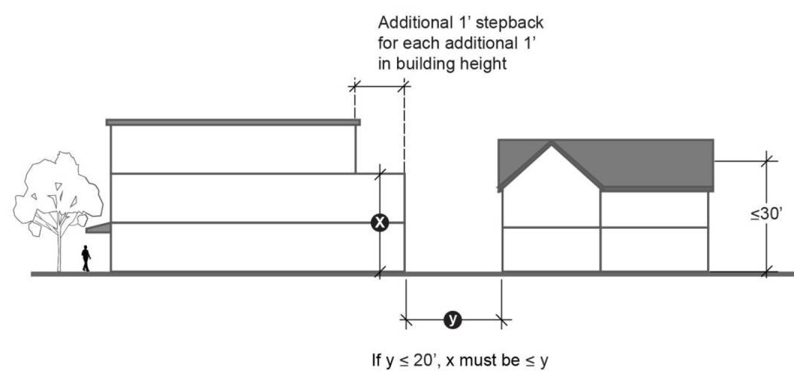
D.
Exceptions to Maximum Building Height.
1.
The structures or structural parts listed below, while subject to Oregon Structural Specialty Code requirements, are not subject to the maximum building height requirements of the applicable base zone:
a.
Chimneys
b.
Elevated storage tanks
c.
Spires or belfries
d.
Domes
e.
Monuments and flagpoles
f.
Emergency services training towers
g.
Observation towers
h.
Telecommunications towers
i.
Cooling towers
j.
Elevator shafts
k.
Electrical transmission towers
l.
Smokestacks
m.
Wind turbines, with the limitation listed in paragraph 2.b below
n.
Photovoltaic or solar equipment, with the limitation listed in paragraph 2.a below
o.
Roof-mounted, non-habitable mechanical penthouses for heating, cooling or ventilation equipment, with or without screening
2.
Limitations in Urban Center Zones. The exceptions to maximum building height listed in paragraph 1 above are limited in certain Urban Center zones as follows:
a.
On-site or roof mounted solar energy production equipment: maximum exception 36 inches above the applicable height limit.
b.
On-site or roof-mounted wind energy production equipment in the UC-OR and UC-RP zones: maximum exception 30 feet above height limit.
3.
Limitations Based on Federal Aviation Regulations. Regardless of the building height standards in any base zone, all structures or parts of structures shall be consistent with Federal Aviation Regulation (FAR) Part 77 "Objects Affecting Navigable Airspace" (14 CFR 77).
4.
Limitations for Structured Parking in MU-N and MU-C Zones. Pursuant to Subsection 12.24.250.C, in the MU-N and MU-C zones for buildings where structured parking is integrated into the building envelope, the floors occupied by parking shall not be counted toward the maximum building height, provided that:
a.
The design of the building with integrated structured parking complies with the standards in Section 12.50.800, and with the standards in Subsection 12.50.360.D. for location and design of structured parking.
b.
The design of the building complies with the design standards contained in Section 12.50.800 regarding building façade and architectural design requirements.
(Ord. 6401 § 1, 2022; Ord. 6322 § 1, 2019; Ord. 6120 § 1, 2015)
12.50.150 - Floor Area Ratio.
A.
Definition and Purpose. Floor area ratio (FAR) is defined in Section 12.01.500. Minimum FAR standards are intended to achieve an increased intensity of non-residential development in light rail zones and Mixed-Use and Urban Center zones, within walking distance of high capacity transit. Minimum FAR standards therefore are not applicable in every zone.
B.
Standards and Measurement Methodology.
1.
Except as provided under subsections C and D below, projects developed after September 4, 2014 must comply with the minimum FAR standard of the applicable base zone, unless a Variance or Adjustment has been granted by the Review Authority pursuant to Section 12.80.150.
2.
Figure 12.50.150-A illustrates the methods to calculate FAR.
Figure 12.50.150-A:
Measuring Floor Area Ratio (FAR)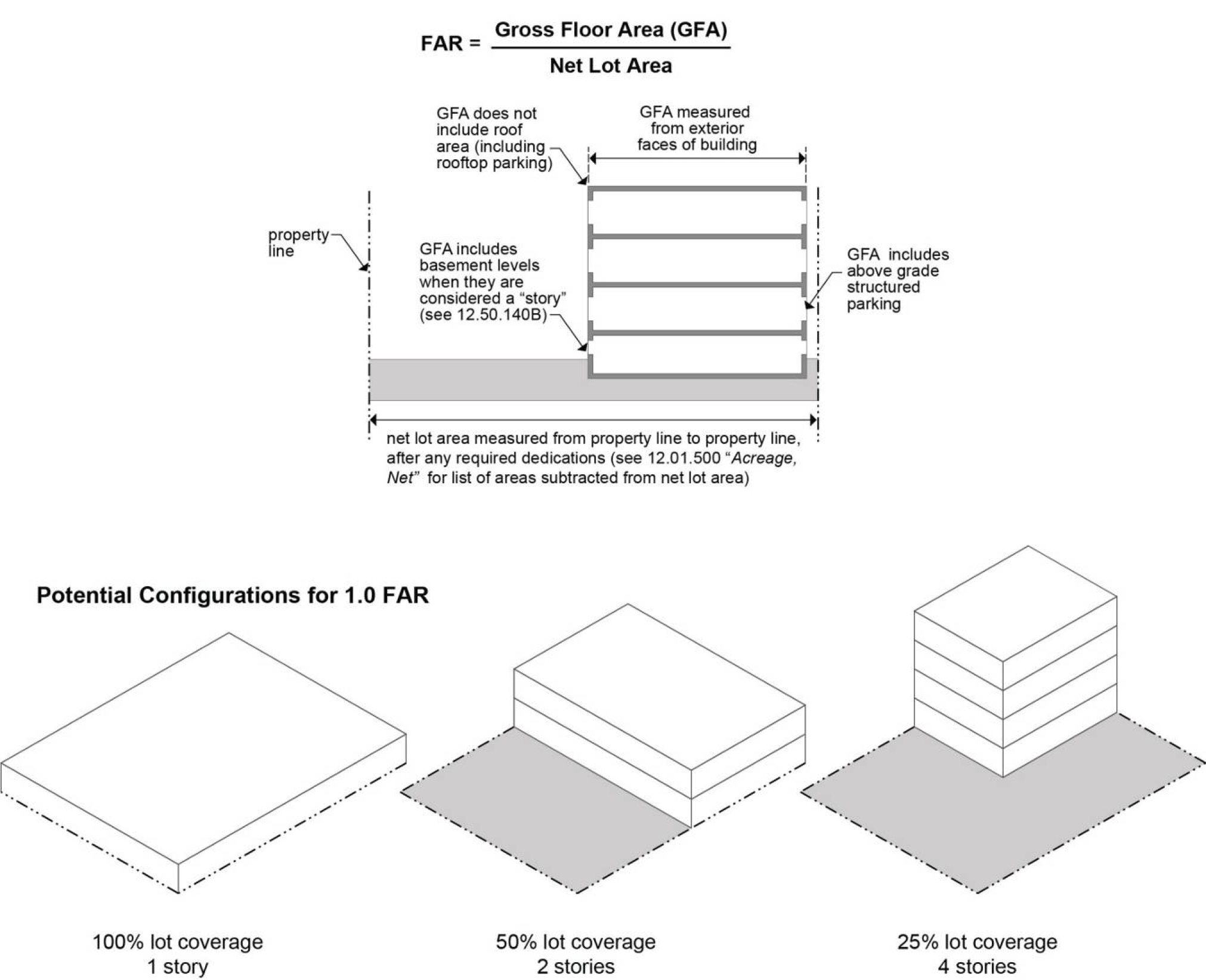
3.
Calculation of Floor Area Ratio in mixed-use buildings includes the entire residential square footage including hallways, common space, mechanical rooms and other utility features.
4.
Floor Area Ratio for automobile service stations includes the service area covered under the service canopy.
5.
Floor Area Ratios for above-grade parking structures includes all areas within the exterior faces of the structure, whether used for parking stalls, ramps and aisles, equipment rooms, stairwells or commercial space.
6.
Floor Area Ratios may be calculated on a project-wide basis including multiple contiguous blocks, pursuant to subsection D below.
7.
In calculating FAR for non-residential development, 25% of employee parking area may be subtracted from net acreage if parking is provided at a ratio of 0.5 spaces per employee or less for the average number of employees in any 8-hour shift.
8.
In calculating FAR for non-residential development on a site containing existing mature or specimen trees as defined in Section 12.50.230, net lot area on a development site may be reduced by subtracting the area within the drip line of the trees, up to a maximum reduction of 35% of the original net area. Applications proposing net lot area reductions to preserve existing trees shall include a certified arborist's report and tree preservation plan. The approval of the development may be conditioned by the Review Authority on implementation of the recommended tree preservation measures.
C.
Exemptions from Minimum Floor Area Ratios in Phased Developments. Phased development in the following categories is exempt from minimum FAR requirements:
1.
Properties subject to an approved Concept Development Plan in the SCR-V zone;
2.
Properties in any phased commercial, industrial or institutional development subject to an approved Concept Development Plan or PUD; or
3.
Any development specified as exempt in a plan district under Subchapters 12.60 through 12.67.
D.
Exceptions to Minimum Floor Area Ratios. Each phase in a phased development must meet the applicable minimum FAR standard unless the following standards are met:
1.
The subject phase is not more than 10% of the total project area;
2.
An FAR reduction in the subject phase is mitigated by an FAR increase of 10% or less in a later phase, which does not rely on redevelopment of early phases, and which is approved in an amended phasing plan and required in a binding legal instrument; or
3.
The subject phase combined with earlier phases meets the minimum FAR requirement.
(Ord. 6401 § 1, 2022; Ord. 6322 § 1, 2019; Ord. 6110 § 7, 2015)
12.50.200 - Site Design.
Site design standards include the following sections:
12.50.210 Usable Open Space
12.50.220 Landscaping
12.50.230 Tree Preservation
12.50.240 Exterior Lighting
12.50.250 Fences, Free-Standing Walls, Hedges and Berms
12.50.260 Sight Distance/Vision Clearance
12.50.270 Waste and Recycling Facilities
(Ord. 6401 § 1, 2022)
12.50.210 - Usable Open Space.
A.
Purpose. Usable open space is defined in Section 12.01.500. Availability of usable open space is an important aspect of livability and benefits public health and well-being. Usable open space standards are intended to assure opportunities for both private relaxation and for community interaction among residents, employees, and customers. These standards are intended to ensure that required usable open space is functional in terms of location, area, and level of improvement and that it remains functional and an asset to the surrounding properties and to the larger community.
B.
Applicability. These standards apply in all zones where usable open space standards are specified in the base zone in Subchapters 12.21 through 12.26.
C.
Exceptions. Where specified, usable open space standards in Subchapter 12.60 supersede the standards of this section.
D.
Exemptions. Single detached dwelling and middle housing developments meeting all of the following thresholds are exempt from the requirements of this section:
1.
The net acreage of the development is 3 acres or less;
2.
The development is within ½ mile (measured in walking distance) of a publicly accessible active open space such as a public park or elementary school; and
3.
Minimum of square footage per lot is provided on at least 65% of the lots in the development, configured in contiguous front, side and/or rear yards with minimum dimensions as shown below:
a.
For single detached residential: 800 square feet area; depth at least 15 feet; width at least 40 feet.
b.
For middle housing: 200 square feet area; depth at least 10 feet; width at least 18 feet.
E.
Exclusions. The following features cannot be counted toward the requirements of this section:
1.
Landscaping planted within 5 feet of building foundations;
2.
The hardscaped surfaces of sidewalks and parking areas;
3.
Private amenities intended for single owner or tenant use and which do not allow shared access;
4.
Perimeter or interior parking lot landscape strips or islands, even if enlarged or enhanced with seating; or
5.
Unimproved land (land which has not been developed or landscaped) or stormwater facilities within a development site unless such land is within a publicly accessible natural or wildlife viewing area.
F.
Area Standards.
1.
Development approved after September 4, 2014 shall provide the usable open space specified in Table 12.50.210-1, unless a Variance or Adjustment has been approved under Section 12.80.150. In middle housing zones, development of duplexes, triplexes, quadplexes, townhouses, and cottage clusters shall be subject to the usable open space standards that apply to single detached residential development.
2.
In applying Table 12.50.210-1 to multi-dwelling residential developments, the 200 square feet per dwelling unit standard shall be used for 1-, 2- or 3-bedroom units. Dwelling units with 4 or more bedrooms shall provide 400 square feet of usable open space per dwelling unit.
3.
The standards of Subsection 12.61.400.E. shall be used in calculating minimum usable open space requirements in the SCC-SC zone.
4.
In a non-residential zone where outdoor seating for eating and drinking establishments are provided, 65% of the private outdoor seating area may be counted toward the usable open space requirement if the area is outside the public right-of-way.
5.
In multi-dwelling or mixed-use developments, commonly accessible courtyards or rooftop courtyards, gardens and terraces may be counted as usable open space if such areas comply with the following standards:
a.
The area is open and available to the public or for the common use of residents and/or building tenants;
b.
The area contains seating and/or recreation facilities; and
c.
Landscaping is provided consistent with the character and function of the space.
G.
Locational Guidelines and Standards.
1.
Purpose. Locational guidelines and standards for usable open space are intended to help ensure that usable open space is sited to provide opportunities for active recreation and "third place" social interaction, except where Level 1, 2, or 3 Significant Natural Resources, 100-year floodplain, or delineated wetlands are present on site as described in paragraph 3.
2.
Guidelines. In determining the location of Usable Open Space within a development, preference should be given to the following:
a.
Public parks, trails, corridors and other open space sites as identified in the Parks and Trails Master Plan and Natural Resource Analysis, a Community Plan in the Comprehensive Plan, or a Plan District per CDC Subchapters 12.60 through 12.67; or as approved by the Parks Commission and accepted by the City Council;
b.
Locations integrated into the overall design of the development;
c.
Easily accessible locations adjacent to public through streets;
d.
Visibility from front yards of adjacent lots or buildings;
e.
Adjacency to multiple properties within or adjacent to the development;
f.
Proximity to neighborhood commercial activity centers;
g.
Otherwise unprotected natural resources and wildlife habitat on the site, particularly if isolated smaller areas can be consolidated, and/or if an opportunity is available to provide passive space in conjunction with the natural resource site; or
h.
Opportunities to create contiguous natural resource corridors with adjacent properties.
3.
Standards for Natural Open Spaces. Usable open space may include passive recreation areas only where inventoried Significant Natural Resources, 100-year floodplain, or delineated wetlands and wetlands buffers are present on site. Such areas may be counted as usable open space under the following standards:
a.
Public accessways and covered viewing areas are provided;
b.
The entire Resource area within the site is enhanced pursuant to CWS standards and Section 12.27.225 if applicable;
c.
Only the on-site portion of the Resource area, floodplain, wetland or wetland buffer area visible from the viewing area is applicable toward the requirement; and
d.
The visible on-site Resource area, floodplain, wetlands or wetlands buffers will not count for more than 25% of the required usable open space.
4.
Standards for Private Open Spaces. In single detached dwelling or middle housing development not exempt under 12.50.210.D. above, and in multi-dwelling residential and mixed-use developments, spaces such as private yards, at grade patios, balconies, rooftop gardens, porches, or terraces may be counted as up to 65% of the usable open space requirement, if such spaces meet the following requirements:
a.
The spaces comply with the dimensions in Table 12.50.210-2;
b.
Patios, balconies or porches are screened or oriented to avoid direct lines of sight into adjacent units; and
c.
At grade spaces are differentiated through use of decorative pavers, pervious pavement, and changes in paving color, pattern and texture.
H.
Improvement Standards.
1.
In Station Communities, Regional Centers, Town Centers or Main Streets as identified on the Hillsboro 2040 Growth Concept Boundaries Map (Comprehensive Plan Section 23.1), usable open space improvements shall be designed to enhance the public pedestrian environment. Improvements may include, but are not limited to, the following:
a.
Hardscaped courtyards;
b.
Water features;
c.
Public art or sculpture;
d.
Weather canopies or sunshades;
e.
Seating areas;
f.
Drinking fountains;
g.
Free-standing planters and/or raised planting beds;
h.
Play structures; or
i.
Other pedestrian-friendly features as approved by the Review Authority.
2.
In Inner and Outer Neighborhoods, Industrial and Commercial areas as identified on the Hillsboro 2040 Growth Concept Boundaries Map (Comprehensive Plan Section 23.1) usable open space improvements shall be designed to provide recreational and/or social interaction among residents, employees or visitors. Improvements in these areas may include, but are not limited to, the following:
a.
Play structures;
b.
Sport courts, fields, or tracks;
c.
Seating areas;
d.
Landscaped or hardscaped courtyards;
e.
Shelters, weather canopies or sunshades;
f.
Free-standing planters and/or raised planting beds; or
g.
Other pedestrian space or design features as approved by the Review Authority.
I.
Usable Open Space Standards: Maintenance and Minimum Area.
1.
The Review Authority may accept as required usable open space an area proposed for a public park, trail, corridor or other open space site consistent with paragraph G.2 above. Such acceptance shall be conditioned upon compliance with the following standards:
a.
If only unimproved land is proposed to be provided, the size and location of the land is consistent with paragraph G.2 above, and the land is accepted by the City Council;
b.
If land and improvements are proposed to be provided, the size and location of the land is consistent with paragraph G.2 above, the improvements of the area consistent with the Parks and Recreation Department standards for public parks, natural areas; and both the land and the improvements are accepted by the City Council and the Parks Commission as applicable.
2.
Land use approvals for developments containing usable open space shall assign maintenance responsibility for the usable open space if the area is not proposed and accepted as a public park under paragraph 1 above. The City may enter into an agreement with a third party for maintenance of public parks, trails, corridors or open space.
3.
Ownership of common open space through a homeowners association or similar entity may be approved only under the limited circumstances listed below:
a.
Where both permanent ownership and maintenance of the private open space areas for a minimum of 40 years have been demonstrated to the satisfaction of the Parks and Recreation Director and the City Attorney; or
b.
In single detached dwelling and townhouse developments, where the common usable open space tract is at least 1.5 acres in area and all improvements therein meet the standards of the Parks and Recreation Department for installation in a public park.
4.
The Review Authority may decline to approve common usable open space if the standards in paragraph 3 above cannot be met.
J.
Usable Open Space in Phased Developments.
1.
Developments constructed in multiple phases may aggregate required usable open space into one or more areas if the following criteria are met:
a.
The location and required area of usable open space for the entire development is shown in the preliminary development application; and
b.
The percentage of total usable open space developed before or with occupancy of the first phase is at least proportional to the percentage of total acreage in the first phase.
2.
If an approved phasing plan allocates the majority of usable open space to a particular lot, a prorated share of the usable open space may be used to calculate FAR and/or residential density in other phases of the development. This provision is applicable whether the usable open space is retained in private ownership or is dedicated to the City as a public park.
3.
If a Planned Unit Development (PUD) application includes 5 acres or more of land proposed for public open space pursuant to paragraph G.2 above, the phasing and allocation plan for the usable open space shall be determined as part of the PUD approval. The Review Authority may condition approval of any phase of the PUD not containing usable open space to guarantee provision of usable open space in later phases.
(Ord. 6401 § 1, 2022; Ord. 6322 § 1, 2019; Ord. 6250 § 1, 2017; Ord. 6178 § 1, 2016; Ord. 6110 § 7, 2015)
12.50.220 - Landscaping.
A.
Purpose. Landscaping in new and existing developments accomplishes the following community purposes:
1.
Enhancing aesthetic and economic value in new developments and the community as a whole;
2.
Unifying new developments with existing neighborhoods and establishing a more pleasant community character;
3.
Softening and buffering large-scale structures and parking lots, and buffering or screening unsightly features;
4.
Providing privacy and creating buffers between residential and non-residential uses;
5.
Aiding in energy conservation by providing shade from the sun and shelter from the wind; and
6.
Reducing stormwater runoff by providing permeable surfaces.
B.
Applicability. The standards of this section shall apply to all Type II and Type III development projects, except for single detached dwellings and middle housing, on properties for which base zone standards require landscaping.
C.
Exemptions. Landscaping within stormwater management facilities are exempt from the standards of this section, and shall be landscaped in compliance with the applicable provisions of the CWS Design and Construction Standards Chapter 3 Sensitive Areas and Vegetated Corridors and Chapter 4 Runoff Treatment and Control, as amended.
D.
Area and Maintenance Standards.
1.
Type II and III development applications submitted after September 4, 2014 shall provide landscaping which meets or exceeds the area percentages specified in the applicable base zone standards, unless a Variance or Adjustment has been granted by the Review Authority pursuant to Section 12.80.150.
2.
The standard in paragraph 1 above may be satisfied by providing vegetated landscaping only or vegetated landscaping in combination with other areas as follows:
a.
Natural vegetation compliant with paragraph E.10 below;
b.
Low Impact Development Approach (LIDA) stormwater facilities compliant with Section 12.64.750; or
c.
Hardscaped plazas or required usable open space compliant with Subsection 12.50.210.H.1.
3.
On development sites in zones having a minimum landscaping percentage standard, required landscaping areas shall be located preferentially as follows: first, within front yard setbacks adjacent to streets; and second, within side or rear yard setbacks between residential and non-residential uses.
4.
All areas of the site not occupied by buildings, parking and loading, storage, landscaping, required usable open space, or protected natural resources shall be improved with a layer of medium or medium-fine bark mulch 2 to 4 inches deep. The bark mulch shall be kept at least 2 inches away from the trunk of any tree and be kept free of weeds.
5.
All required plantings shall be maintained to the following standards:
a.
Each planting shall receive regular weekly watering as needed to ensure the plants are not stressed during the hotter portions of the growing season (from April 15th through October 15th). Water shall be provided in a manner that allows penetration into the soil around the tree.
b.
Stakes and ties shall be maintained and repaired as needed. Stakes and ties shall be removed if the trees are well rooted into the native soil and are able to withstand local wind conditions.
c.
A minimum 3-foot diameter planting area around each tree shall be maintained with a layer of medium or medium-fine bark mulch 2 to 4 inches deep. The bark mulch shall be kept at least 2 inches away from the trunk of the tree and be kept free of weeds.
d.
Any planting falling into one of the following conditions shall be replaced.
i.
Dead Plant. Any plant that has no live growth originating in all or a portion of the scaffolding branches.
ii.
Stressed Plant. Any plant that has lost 50% or more of its total foliage or has a reduction of 50% of normal leaf size for that species.
E.
Improvement Standards.
1.
Minimum Sizes and Spacing for Landscaping Materials. Table 12.50.220-1 shows the minimum sizes and spacing for landscaping materials at planting:
2.
Installation of plant materials shall be in accordance with the American Nursery and Landscaping Association standards and the following standards:
a.
Plant materials shall be nursery stock or the equivalent quality and installed to industry standards or better; and
b.
Plant materials shall be staked to current industry standards or better. Stakes and guy wires shall not interfere with vehicular or pedestrian traffic.
3.
For nonresidential development, required landscaping shall be located, selected and installed as an integral part of the site, building and streetscape design of the development site.
4.
Where practicable, landscaping species shall be selected to correspond in scale with the structures in the project, including selection of taller-height species adjacent to taller buildings, if not designated as not permitted by overhead utility lines or reduced setbacks.
5.
Vegetated landscaping shall include a mixture of vertical and horizontal elements such as ground cover, shrubs and trees. Trees shall be incorporated in landscaped areas that are at least 10 feet in depth and abut a public street.
6.
Nuisance plants as defined in Section 12.01.500 are not permitted for use in any landscaping.
7.
Use of drought-tolerant plant species is encouraged in required landscaping, and may be required when irrigation is not available. Drought-tolerant grasses, shrubs or trees may also be used outside the required landscaping areas specified in paragraphs C.3 and C.4 above. Irrigation shall be provided in required landscaping areas for plants that are not drought-tolerant.
8.
Natural existing vegetation may be counted toward the landscaping requirement, provided that the natural vegetation is maintained continuously to remove nuisance plants and to keep the natural vegetation alive.
9.
Required landscaping in surface parking lots is subject to the standards in Section 12.50.360.F. in addition to the standards in this section.
10.
Approved landscaping in common open space areas, parking strips, and in all yards adjacent to a public or private street shall be installed prior to issuance of certificates of occupancy or final building inspections. With City approval, financial assurance acceptable to the Planning Director may be provided to ensure installation of required landscaping not more than 6 months following acceptance of public infrastructure or final certificates of occupancy.
11.
Landscaping provision and maintenance are continuing obligations of the property owner. If plantings die, the property owner shall replace each planting with an equivalent type (i.e., evergreen shrub replaces evergreen shrub, deciduous tree replaces deciduous tree, etc.). All man-made landscaping features required as part of a development approval shall be maintained in good condition or replaced with substantially similar features.
12.
Landscaping plans for development projects (excluding subdivisions) 1.0 gross acre or larger shall be prepared by a licensed landscape architect or other landscaping professional as accepted by the Review Authority.
13.
Development of landscape plans should be completed in coordination with the local electric utility including pre-design, building, and maintenance phases.
F.
Design Guidelines. In addition to the standards in subsections D and E above, developments are encouraged to meet the following guidelines:
1.
Landscaping should be used to enhance pedestrian orientation by creating a sense of enclosure and to reduce the scale of large buildings and paved areas, especially in higher density areas surrounding light rail stations and in designated town centers and regional centers.
2.
Arbors or trellises supporting landscape materials should be considered for ornamentation of exterior walls.
3.
Landscaping shall be selected, located, and installed to reduce adverse impacts on surrounding properties from root or canopy systems which may extend across property lines.
4.
Plant materials identified by the Review Authority as having potential to damage or disrupt existing underground utilities, curbs, sidewalks, or gutters through invasive root structures should not be used in any landscaping.
5.
Where feasible, tree planting should be consistent with or in excess of the standards of the 2021 American National Standards Institute A300 standards.
(Ord. No. 6488, §§ 1, 2(Exh. A), 12-3-2024; Ord. 6401 § 1, 2022; Ord. 6322 § 1, 2019; Ord. 6178 § 1, 2016)
12.50.230 - Tree Preservation.
A.
Purpose. Tree preservation establishes character and livability in new neighborhoods and preserves the existing character in both residential and non-residential neighborhoods. Mature and specimen trees provide shade and temperature moderation, store and maintain carbon levels, and reduce air-borne pollutants. To encourage preservation of mature and specimen trees the City provides the option in Subsection 12.50.120.C.3. to reduce net acreage on project sites, for purposes of calculating residential densities and floor area ratios, where existing trees are preserved.
B.
Applicability. The standards of this section shall apply to all Type II and Type III development applications.
C.
Standards for Mature Tree Preservation. These standards apply to deciduous trees 8 inches or greater in diameter measured 4.5 feet above native grade, or coniferous trees 30 feet or taller in height.
1.
Development shall be sited and constructed to avoid removing or damaging mature trees. The burden of proof is on the applicant to demonstrate the necessity of tree removal.
2.
Applications for development of sites with stands of 5 or more overlapping mature tree canopies shall include a tree preservation plan prepared by a Certified Arborist. The plan shall identify trees which can be retained and which must be removed to accommodate the development or promote public safety. The plan shall also identify areas where potential wind throw may occur as a result of partially removing a stand of trees and recommend measures to prevent wind throw.
3.
The Review Authority may condition a land use approval to avoid disturbing tree roots by grading activities and to protect trees and other significant vegetation to be retained from construction activity impacts. Such conditions may include the retention of a qualified consulting arborist or horticulturist during and/or after site grading, and a tree maintenance and management program to provide protection to the trees as recommended by the arborist.
4.
Trees shown as protected or preserved on the tree protection plan shall be marked and protected on site by a construction fence placed at least 5 feet outside the drip line(s) illustrated in Figure 12.50.230-A. No soil compaction, material or spoils storage shall be allowed within the drip line(s). This provision shall be enforced as a requirement of any Building and Engineering Permits for the project.
Figure 12.50.230-A:
Tree Dripline Location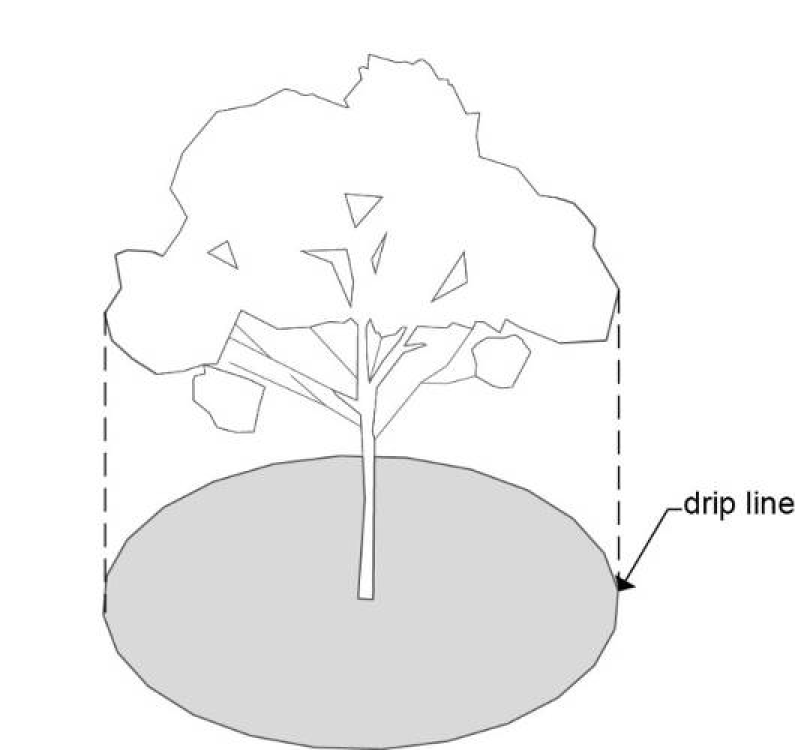
5.
Where the Review Authority determines that mature trees meet the criteria above, removal of the trees shall be mitigated by 1 of the following alternatives:
a.
Trees replaced on-site in accordance with an approved landscape plan including new plantings of similar character at least 2½″ in caliper;
b.
A fee in-lieu-of replacement may be paid by the developer to the City. The amount of the in lieu of payment shall be approximately equal to the market value of the replacement trees cited in subparagraph a, above; or
c.
Replacement trees to be planted off-site in a public open space or park.
6.
Under Section 12.80.150, the applicant may seek an adjustment or variance for reduced setbacks to avoid removal of mature trees, provided measures are also taken to preserve the health of the trees. If approved, reduced setbacks or numbers of parking spaces must remain in compliance with Building Division requirements.
7.
The Planning Director may request that the Building Official or the Public Works Director issue a Stop Work order to halt construction if site or building construction violates the standards of this section either intentionally or through negligence. If construction is halted, a legally binding mitigation plan and agreement shall be executed prior to resumption.
D.
Standards for Specimen Tree Preservation. In addition to the standards in subsection C above, the standards in subsection D apply to the Specimen Trees described in Table 12.50.230-1.
1.
No specimen tree shall be removed or damaged during development construction unless 1 or more of the following criteria are met:
a.
A Certified Arborist determines that the tree:
i.
Is a safety hazard to persons or property due to its location or condition; or
ii.
Is a dangerous tree as defined in Section 12.01.500; or
iii.
Was diseased, weakened, or dying before construction began and no practicable means is available to preserve it;
b.
A Registered Engineer determines that removal of the tree is necessary:
i.
To accommodate construction equipment access where there is no practicable alternative route; or
ii.
To accommodate grading necessary for required storm water management or structural building integrity, and there is no practicable grading alternative to meet those requirements; or
iii.
To accommodate proposed buildings or other permanent improvements, and there is no practicable alternative location or design option for the improvements at the same scale within the lot.
2.
Under Section 12.80.150, the applicant may seek an adjustment or variance for reduced setbacks or a reduction in the number of parking spaces to avoid removal of specimen trees, provided measures are also taken to preserve the health of the trees. If approved, reduced setbacks or numbers of parking spaces must remain in compliance with Building Division requirements.
(Ord. No. 6488, §§ 1, 2(Exh. A), 12-3-2024; Ord. 6401 § 1, 2022; Ord. 6322 § 1, 2019)
12.50.240 - Exterior Lighting.
A.
Purpose. Lighting standards ensure that new development provides functional security for persons and property and allows extended use of properties into nighttime hours. Lighting standards also ensure that lighting is installed and maintained to avoid unnecessary increases in ambient nighttime light levels and adverse impacts on adjacent properties.
B.
Applicability. Except as provided in subsection E below, the standards of this section shall apply to all Type II and Type III development applications in which exterior lighting is proposed or required as a condition of approval, unless a Variance or Adjustment has been granted by the Review Authority pursuant to Section 12.80.140 Variances and Adjustments.
C.
Standards.
1.
Development applications shall include a lighting plan showing locations and specifications for all lighting used to illuminate public and private streets, buildings, sidewalks, multi-use paths, parking lots, plazas, or open space areas. The lighting plan shall be evaluated during the land use approval process for compliance with the standards of this section.
2.
For safety purposes, lighting shall be provided throughout the on-site pedestrian circulation system, including street frontages, sidewalks, multi-use paths, parking lots, buildings, and plazas. The on-site pedestrian circulation system shall be lighted to a minimum level of 2 foot-candles to enhance pedestrian safety and allow use at night.
3.
Required bicycle parking shall be lighted to a minimum 3 foot-candles to allow secure use at night.
4.
The minimum lighting level for building entries of new multi-dwelling, retail, commercial, office, industrial and institutional buildings located within 300 feet of the property boundaries of a major transit stop shall be 4 foot-candles. The minimum lighting level for all other primary building entrances shall be 3 foot-candles. Lights shall be 6 to 12 feet in height and the light source shall be shielded to reduce glare consistent with subsection D below.
5.
Maximum lighting levels for pedestrian circulation systems, required bicycle parking, and building entrances shall be 4 foot-candles.
6.
Lighting plans shall also show any proposed exterior architectural or aesthetic lighting used to create visual interest or emphasize building features. Aesthetic and architectural lighting shall also be evaluated during the land use approval process for compliance with the standards of this section.
7.
Foreground spaces, such as building entrances and plaza seating areas, shall use pedestrian-scale lighting that defines the space without glare. Background spaces such as parking lots shall be illuminated as unobtrusively as practicable to meet the functional needs of safe circulation and of protecting people and property.
8.
Site lighting that could be confused with warning, emergency, or traffic signals is not permitted.
9.
Site lighting that could be confused with airport lighting is not permitted.
D.
Light Trespass Standards.
1.
Light Trespass. Maximum lighting levels at property lines generally shall not increase lighting level more than 1.75 foot-candles 10 feet beyond the property line, as illustrated in Figure 12.50.240-A:
Figure 12.50.240-A:
Examples of Light Trespass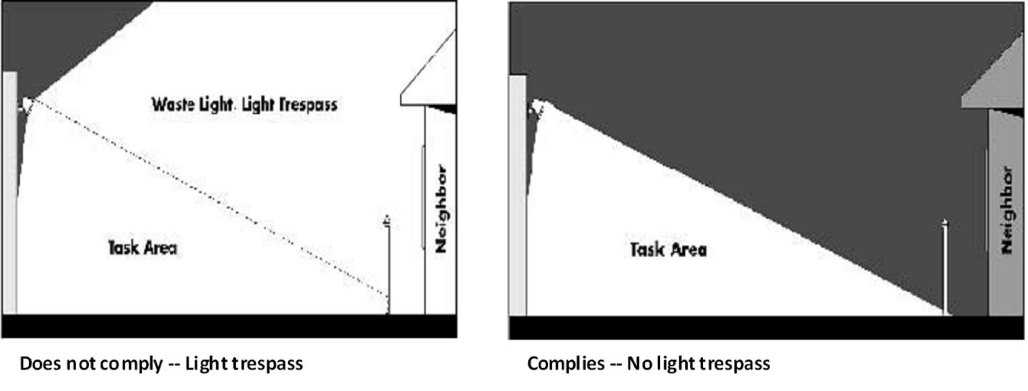
2.
Shielding. Any light source or lamp that emits more than 900 lumens (13 watt compact fluorescent or 60 watt incandescent) shall be concealed or shielded with an Illumination Engineering Society of North America (IESNA) full cut-off style fixture with an angle not exceeding 90 degrees to minimize the potential for glare and unnecessary diffusion on adjacent property. Examples of shielded light fixtures are shown in Figure 12.50.240-B:
Figure 12.50.240-B:
Examples of Shielded Light Fixtures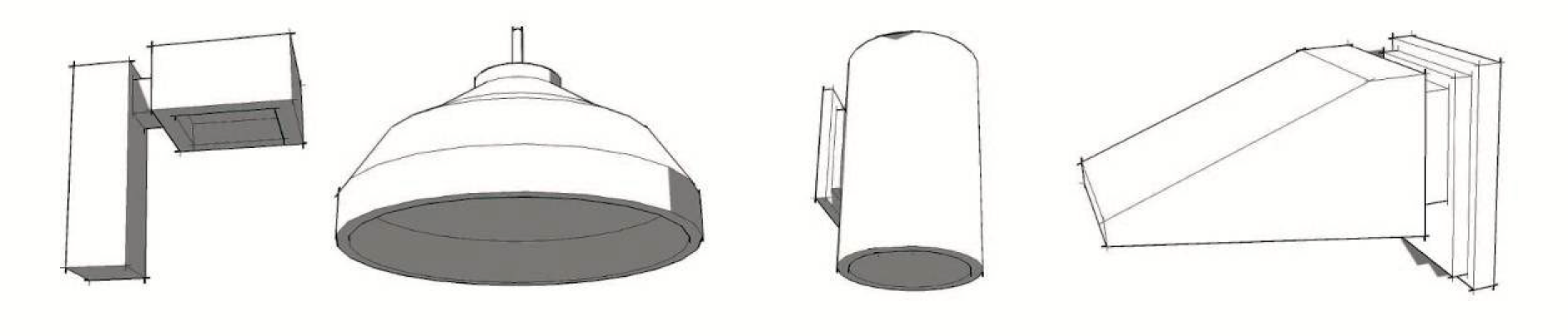
E.
Exemptions. The following types of lighting are not subject to the requirements of this section:
1.
Public street and right-of-way lighting (standards for street lighting are addressed in the Public Works Design and Construction Standards);
2.
Temporary decorative seasonal lighting;
3.
Temporary lighting for emergency or nighttime work and construction;
4.
Temporary lighting for theatrical, television and performance areas, or for special public events;
5.
Lighting for a special district, street or building that, according to an adopted City plan or ordinance, is determined to require special lighting aesthetics as part of its physical character;
6.
Lighting required and regulated by the FAA; and
7.
Lighting for outdoor recreational uses such as stadiums, driving ranges, ball diamonds, playing fields, tennis courts and similar uses, provided that: (a) light poles are not more than 80 feet tall, (b) maximum illumination at the property line is not brighter than 2 foot-candles, and exterior lighting is extinguished no later than 11:00 p.m.
(Ord. 6401 § 1, 2022; Ord. 6322 § 1, 2019; Ord. 6120 § 1, 2015)
12.50.250 - Fences, Free-Standing Walls, Hedges and Berms.
A.
Purpose. Fences, walls, hedges and berms mark property boundaries and provide privacy and security. Standards for construction and installation of fences, walls, hedges and berms are intended to ensure that these features are attractive from the public view, accomplish their intended purposes, and are reasonably maintained for both private and public benefit.
B.
Applicability. The standards of this section shall apply:
1.
To all Type II or III development applications in which fences, hedges, free-standing walls or berms are proposed or required as a condition of approval; and
2.
To any fences, hedges, free-standing walls or berms installed outside the land use approval process.
C.
Fence Permit Required; Exception.
1.
Except as provided in paragraph 2 below, installation of a new fence or wall, or relocation of a portion of an existing fence or wall, shall require submittal and approval of a fence permit application according to the process specified in Section 12.80.060.
2.
When required through a Type II or Type III land use approval, a separate fence permit is not required for installation of a fence, free-standing wall, hedge or berm consistent with that approval.
D.
Residential Fence and Wall Standards. These standards in this subsection apply to all residential fences and walls.
1.
Fences and walls in residential zones are limited to 6 feet 2 inches in height except when:
a.
A residential zone abuts a Commercial, Mixed-Use, Urban Center, Institutional or Industrial zone, fences may be up to 8 feet 2 inches in height.
b.
On interior lots, fences and walls within a front yard setback shall not exceed 4 feet 2 inches.
c.
On corner lots, through lots and multiple frontage lots, the 4-foot 2-inch height limitation applies only at the front yard setback abutting the façade with the front door.
d.
On flag lots, the height limit of 4 feet 2 inches does not apply in the front yard setback.
2.
Soundwalls installed adjacent to light rail facilities are exempt from these height restrictions above.
3.
Fences and walls in residential zones shall not conflict with vision clearance requirements in Section 12.50.260.
4.
One arbor, gate, or similar garden structure not exceeding 8 feet in height and 4 feet in width is allowed within the front yard outside a vision clearance triangle.
5.
Use of barbed wire, razor wire, and electric fences shall be consistent with the requirements of the Hillsboro Municipal Code.
6.
Chain link fences shall include a top rail for security and maintenance. Chain link fences installed adjacent to landscaped areas, wetlands, or open space areas shall have a black, dark brown, or dark green powder coating.
E.
Fencing and Wall Requirements for New Residential Developments. In addition to the standards in subsection D, above, the following standards apply to all applications for Development Review, preliminary Subdivision plat or Planned Unit Development concept plan approval for new residential development.
1.
Applications for Development Review, preliminary Subdivision plat or Planned Unit Development concept plan approval for new residential development shall submit proposed fencing or wall plans in compliance with the standards in Table 12.50.250-1.
2.
Perimeter street fences and walls shall be installed by the developer prior to the acceptance of public infrastructure, according to the standards listed in Table 12.50.250-1.
3.
Uniform interior yard fences and walls shall be constructed during or after home construction, according to the fencing plan approved during preliminary review.
F.
Commercial, Industrial, and Institutional Fence and Wall Standards.
1.
Fences and walls in commercial, industrial, and institutional zones shall not exceed 8 feet in height.
2.
Chain link fences shall include a top rail for security and maintenance. Chain link fences installed adjacent to landscaped areas, wetlands, or open space areas shall have a black, dark brown, or dark green powder coating.
3.
Use of electric fences and/or fences topped with barbed wire, razor wire, or similar installations shall comply with the requirements of the Hillsboro Municipal Code.
4.
Soundwalls installed for sound attenuation are exempt from the height restrictions contained in this section.
G.
Standards for Hedges. In all zones, vegetation hedges may be installed in compliance with the following standards:
1.
Hedge plantings shall not include nuisance plants as defined in Section 12.01.500;
2.
Hedge heights may exceed the maximum fence height standards in any zone;
3.
Hedges may be installed without a fence permit, but must comply with the vision clearance requirements in Section 12.50.260; and
4.
Hedges shall not extend into the public right-of-way.
H.
Standards for Berms. As an alternative or in addition to perimeter fences or walls, projects may include perimeter earthen berms. Berms in residential developments shall be a maximum 6 feet in height, with a maximum 25% slope. Berms in commercial, industrial or institutional developments may exceed this height and/or slope if approved through the Development Review process. If approved, berms shall include stabilizing landscaping on all sloped areas; irrigation; and provision for drainage at the toe of all slopes.
(Ord. 6451 § 1, 2023; Ord. 6401 § 1, 2022; Ord. 6393 § 1, 2021; Ord. 6322 § 1, 2019; Ord. 6294 § 1, 2019; Ord. 6120 § 1, 2015)
12.50.260 - Sight Distance/Vision Clearance.
A.
Purpose. Specified areas along intersection approach legs and across their included corners should be clear of obstruction that might block a driver's view of potentially conflicting vehicles, bicycles, or pedestrians. When established and maintained in triangular areas at street intersections or intersections with alleys or driveways, these vision clearance areas (also called clear sight triangles or sight distance areas) ensure that drivers, bicyclists and pedestrians have clearer views of crossing traffic, which improves intersection safety for all parties. Corner lots or lots on curvilinear streets may also have additional setback or site design requirements to ensure proper sight distance.
B.
Applicability.
1.
The standards of this section apply to:
a.
All development applications:
i.
At the intersection of 2 or more streets;
ii.
At the intersections of a street and an alley;
iii.
At the intersections of a street or alley and common driveway; and
iv.
At the intersection of a street and a mixed-use, commercial, industrial or institutional use driveway.
b.
Any development occurring outside the land use approval process.
2.
The areas subject to these standards are those portions of the vision clearance areas located on private property outside the public right-of-way that avoids obstruction of intersection site distance for a public street approach to a public street or driveway approach to a public street. Vision clearance requirements in the public right-of-way are specified in the Public Works Design and Construction Standards.
C.
Standards.
1.
Projects at intersections listed in paragraph B.2 above must provide intersection sight distance as measured and recommended in accordance with the current AASHTO Policy on Geometric Design of Highways and Streets, unless otherwise approved in writing by the City Engineer or Road Agency Engineer. Sight distances shall be based on the 85th percentile or posted speed of the cross street (whichever is higher) as determined by a traffic engineering study.
2.
Projects at intersections within private property other than those listed in paragraph B.2 above must provide sight distance in compliance with Figure 12.50.360-A.
3.
With the exceptions of intersections in the SCC-DT zone listed in paragraphs 4 and 5 below, required sight distance triangles shall contain no plantings, walls, structures, or temporary or permanent obstructions between 30 inches and 10 feet in height, except occasional tree trunks or poles. The vertical distances in this section shall be measured vertically from the top of the curb or, if there is no curb, from the centerline street grade.
4.
Projects within the SCC-DT zone or within a Mixed-Use Town Center or Village Center Core Area established in accordance with Section 12.65.030 must meet the intent of the AASHTO standard in paragraph 1 above, but the sight distance triangle may be occupied by a plaza, provided the location and size of any furniture, planters or landscaping in the plaza do not in the opinion of the City Engineer or the Road Agency Engineer create a sight distance hazard.
5.
Projects within the SCC-DT zone or within a Mixed-Use Town Center or Village Center Core Area established in accordance with Section 12.65.030 may also meet the intent of the AASHTO standard in paragraph 1 above but may provide a structural support for upper stories above the sight distance triangle, provided the location and size of such supports do not in the opinion of the City Engineer or the Road Agency Engineer create an unsafe sight distance hazard.
6.
The Review Authority may condition land use approvals for projects on corner lots or lots on curvilinear streets to have additional setbacks in order to meet sight distance requirements.
7.
Sight distance triangle locations and dimensions shall be based on ultimate street and cross street rights-of-way.
D.
Exceptions. Sight distance requirements at intersections may be modified at the discretion of the City Engineer or Road Agency Engineer. Requests for modifications must be hardship driven and submitted in writing prior to or during the land use application review process. Any approval of a sight distance triangle exception shall be made in writing by the City Engineer or Road Agency Engineer, and may be conditioned to meet the intent of this standard.
E.
Enforcement. To enforce this standard following approval of a land use application, the Review Authority may impose conditions on a land use application approval to require plat notes, deed restrictions or provision of sight distance easements.
(Ord. 6451 § 1, 2023; Ord. 6401 § 1, 2022; Ord. 6322 § 1, 2019; Ord. 6258 § 1, 2018; Ord. 6110 § 7, 2015)
12.50.270 - Waste and Recycling Facilities.
A.
Purpose. These standards are intended to assure that development incorporates functional and adequate space and access for on-site storage and efficient collection of mixed solid waste and recyclables prior to pick up and removal.
B.
Applicability. Except as provided in subsection E, below, the standards of this section apply to:
1.
All new construction subject to a Type II or III review procedure in any of the following zones:
a.
Commercial;
b.
Mixed-Use;
c.
Industrial.
2.
All new construction of institutional development subject to a Type II or III review procedure in any zone; and
3.
All expansions of existing commercial, mixed-use, industrial or institutional development which meets the threshold of the Development Review process as described in Subsection 12.80.040.B. paragraph 5 or 6; and
4.
Construction of new residential structures which include 5 or more dwelling units; and
5.
In any zone, any expansion of existing multi-dwelling residential development which meets the threshold of the Development Review process as described in Subsection 12.80.040.B. paragraph 5 or 6.
C.
Standards.
1.
Combined Storage Areas. Storage areas for townhouses, multiple dwelling structures, or multiple uses on a single site or adjacent sites may be combined and shared. Storage area space requirements can be satisfied with a single location or multiple locations, and can combine both interior and exterior locations.
2.
Co-Location. To encourage its use, the storage area for recyclables shall be co-located with the storage area for residual mixed solid waste.
3.
Storage Area Size. Buildings shall provide the minimum storage areas shown in Table 12.50.270-1 below. If a building has more than one of the uses listed, the storage area requirement for the entire building shall be the sum of the requirements for the areas of each use. For purposes of this calculation, the floor area of the storage facility itself shall not be included in the gross floor area (GFA).
4.
Storage Height. The specific areas in paragraph 3 above are based on a storage height of 4 feet. Vertical storage higher than 4 feet but no higher than 7 feet may be used to accommodate the same volume of storage in a smaller floor area. If vertical or stacked storage is proposed, the site plan shall include drawings to illustrate the layout of the storage area and dimensions of containers.
D.
Location, Design and Access Standards for Storage Areas.
1.
Location Standards.
a.
Exterior storage areas shall be located in central and visible locations on the site to enhance security for users.
b.
Storage areas shall not obstruct on-site or off-site pedestrian or vehicle traffic movement.
c.
Storage areas shall be accessible to waste collection vehicles, on accessways compliant with paragraph 3 below, without requiring backing movements onto a public or private street or alley.
2.
Design Standards.
a.
Exterior storage areas shall be contained within opaque enclosures and gates, built with the same type of materials as the primary structure on the site. Storage areas shall be screened and buffered from on-site or existing off-site residential living spaces.
b.
Gate openings which allow access to users and haulers shall be provided on all storage areas. Gate openings for haulers shall be a minimum of 12 feet wide and capable of being secured in both closed and open positions.
3.
Access Standards.
a.
Storage areas shall be accessible to users at convenient times of the day, and to waste collection service personnel on the day and approximate time collection service is scheduled. However, access to storage areas may be limited for security reasons.
b.
Storage areas shall be designed and surfaced to be easily accessible to waste collection trucks and equipment. Storage areas and vehicle approach drives shall be paved, and the maximum slope on any approach drive shall be no greater than 3%.
c.
The full length of the accessway to any enclosed or covered storage area shall provide at least 12 feet horizontal clearance and 20 feet vertical clearance shall be provided to accommodate collection trucks and containers.
d.
If only a single access point is available to the storage area, adequate turning radius shall be provided to allow collection vehicles to safely exit the site by driving forward.
E.
Exemptions. Curbside collection of solid waste and recyclables from individual dwelling units in townhouse buildings containing 5 or more units on a public or private street or alley may be permitted with the consent of the applicable collection service.
(Ord. 6401 § 1, 2022; Ord. 6322 § 1, 2019)
12.50.300 - Vehicle Parking.
Vehicle parking standards include the following sections:
12.50.310 Purpose, Applicability and Maintenance Responsibilities
12.50.320 Number of Spaces
12.50.330 Exempt Parking
12.50.340 On-Street Parking
12.50.350 Vehicle Parking and Loading: Location
12.50.360 Vehicle Parking and Loading: Design and Improvements
(Ord. No. 6488, §§ 1, 2(Exh. A), 12-3-2024; Ord. 6401 § 1, 2022)
12.50.310 - Purpose, Applicability and Maintenance Responsibilities.
A.
Purpose.
1.
Maximum off-street parking standards are intended to accommodate the majority of parking needs for residents, customers and employees, encourage use of alternative travel modes such as transit, bicycling and walking, and reduce impervious surface area which receives only sporadic parking use.
2.
The City of Hillsboro does not have standards which require mandate the provision of parking. This is intended to promote density, housing affordability, and sustainable transportation; encourage market-driven development; enhance urban design and livability; stimulate economic growth; and create more flexible, efficient land patterns. This also implements the requirements of OAR 660-012-0400.
B.
Applicability.
1.
The standards of this section shall apply to all development, including change of use, which includes or is required to include parking, including carpool, vanpool, loading and bicycle parking except for development which meets the general exemptions in Subsection 12.50.030.C.
2.
The location and improvements for vehicle parking shall be constructed under any of the following circumstances:
a.
Construction of a new building;
b.
Expansion of an existing building by either 50% of its existing floor area or 3,000 square feet, whichever is less; or
c.
Change in Oregon Residential Specialty Code or Oregon Structural Specialty Code occupancy classification of an existing building.
3.
No provision of this section shall be construed to require the removal of pre-existing parking spaces in excess of the maximum number required or allowed.
C.
Maintenance.
1.
The provision and maintenance of off-street vehicle parking and loading spaces are continuing obligations of the property owner.
2.
Parking spaces shall be available for parking operable vehicles of residents, customers, patrons, and employees, and shall not be used for vehicle or materials storage or for fleet parking.
(Ord. No. 6488, §§ 1, 2(Exh. A), 12-3-2024; Ord. 6401 § 1, 2022; Ord. 6322 § 1, 2019; Ord. 6120 § 1, 2015)
12.50.320 - Number of Spaces.
A.
All development shall include not less than 1 Americans with Disabilities Act compliant accessible parking space if the context or use of the site meets any of the following:
1.
The structure or use requires accessible parking per the Oregon Structural Specialty Code or Oregon Residential Specialty Code;
2.
The adjacent street does not have designated on-street parking; or
3.
The use is not an accessory dwelling unit.
B.
If provided off-site, parking for people with disabilities must be located within the shortest possible distance of an accessible entrance via an accessible path and no greater than 200 feet from that entrance.
C.
Notwithstanding 12.50.320(A), the Review Authority may determine through a Type II procedure that the accessible space is not required under ORS 447.233 and not necessary or feasible.
D.
Maximum parking requirements are calculated based on the location of a site in Zone A or Zone B shown on Figure 12.50.320-A. If any portion of a lot or parcel is within Zone A, the entire site shall be construed to be within Zone A.
E.
For land uses located in Zone A with more than 65,000 square feet of floor area, surface parking may not consist of more area than the floor area of the building.
1.
Non-surface parking such as tuck-under parking, parking underground, and subsurface parking, and parking structures are exempted from this calculation.
2.
Surface parking shall be measured inclusive of all surface area on which a vehicle is designed to maneuver including all parking stalls, driveways and drive-through lanes within the property regardless of length, and all maneuvering areas regardless of depth.
3.
Paved areas not for use by passenger vehicles, such as loading areas or outdoor storage of goods or materials, are not counted as surface parking area.
F.
Uses may share off-site parking if the shared parking is located within 800 feet of the uses. Shared parking located off-site shall be signed for use by the remote development.
Figure 12.50.320-A:
Maximum Parking Zones Map
* As determined by the Building Official.
(Ord. No. 6488, §§ 1, 2(Exh. A), 12-3-2024; Ord. 6401 § 1, 2022; Ord. 6323 § 1, 2019; Ord. 6322 § 1, 2019; Ord. 6294 § 1, 2019; Ord. 6275 § 1, 2018; Ord. 6149 § 1, 2015; Ord. 6110 § 7, 2015)
12.50.330 - Exempt Parking.
The following types of parking are exempt from the maximum requirements specified in Tables 12.50.320-1 through 12.50.320-5:
A.
Employee car/vanpool parking spaces. As used in this section, a "carpool" is 2 or more commuters, including the driver, who share the ride to and from the destination. A "vanpool" is 5 or more commuters, including the driver, who share the ride to and from the destination on a regular basis;
B.
Dedicated valet parking spaces;
C.
Fleet parking;
D.
Commercial parking;
E.
Parking for vehicles for sale, lease or rent;
F.
Parking spaces in structures located outside Zone A; and
G.
Parking spaces reserved for customer vehicles before or after servicing, provided such spaces meet the following standards:
1.
The spaces are not designated for carpool, vanpool or handicapped parking; and
2.
The number of service spaces is not more than 25% of the total number of spaces on-site.
(Ord. 6401 § 1, 2022; Ord. 6322 § 1, 2019)
12.50.335 - Reserved.
Editor's note— Ord. No. 6488, §§ 1, 2(Exh. A), adopted Dec. 3, 2024, repealed § 12.50.335, which pertained to exceptions to required parking standards and derived from Ord. 6294 § 1, adopted in 2019; Ord. 6322 § 1, adopted in 2019; and Ord. 6401 § 1, adopted in 2022.
12.50.340 - On-Street Parking.
On-street spaces constructed with a specific development may not be used exclusively by that development, but are available for general public use at all times. Except for those placed by the City, signs, other markings, or actions limiting general public use of on-street parking spaces are not permitted.
(Ord. No. 6488, §§ 1, 2(Exh. A), 12-3-2024; Ord. 6401 § 1, 2022; Ord. 6322 § 1, 2019)
12.50.350 - Vehicle Parking and Loading: Location.
A.
Parking Location: General Provisions.
1.
Except as may be allowed within middle housing land divisions or within specific plan districts, off-street parking for residential uses in all zones shall be located on the same lot with the residential use.
2.
Except as may be allowed within specific plan districts, parking for non-residential uses in standard zones may be located off-site, not farther than 500 feet from the use it serves. Parking for non-residential uses in light rail, mixed-use or urban center zones may be located off-site, not farther than 800 feet from the use it serves.
3.
If parking is provided off-site, the distance from the parking to the use shall be measured from the nearest parking space to the building entrance on a sidewalk or other pedestrian route. The location and terms of the off-site parking shall be specified in a written deed, lease or contract, signed and notarized by all affected property owners and filed with the Planning Department.
B.
Loading Location: General Provisions.
1.
Schools and Child Care Facilities. Access drives designed for continuous forward flow of passenger vehicles shall be provided at any school or child care facility with a capacity of 25 or more students.
2.
Merchandise, Materials, or Supplies. Off-street truck loading docks proposed for new non-residential development shall be sited and maintained to accommodate anticipated truck sizes, numbers and movement on-site, without blocking public streets. Off-street parking may be used for loading and unloading operations only during off-peak hours.
C.
Off-Street Surface Parking Location in Standard Zones.
1.
Off-street surface parking located within the front or side yard setbacks of single detached or attached residential or middle housing lots, shall be located on a driveway providing access to a garage or carport, or if there is no garage or carport, within a paved area that accommodates no more than 2 parking spaces.
2.
In development projects adjacent to major pedestrian routes or transit trunk routes, the location of surface parking relative to the building(s) it serves shall comply with the building orientation and pedestrian connection requirements of Section 12.50.400.
3.
If buildings parking, required landscaping and usable open space do not occupy an entire site, the parking shall be sited to meet the following standards:
a.
The location of the parking permits additional development on the site; and
b.
The parking does not abut a significant natural resource area.
D.
Off-Street Surface Parking Location in Light Rail Zones.
1.
Parking for free-standing residential structures in the SCC-DT zone shall be incorporated within the structure.
2.
Surface parking, loading docks or maneuvering areas shall not be temporarily or permanently located adjacent to, cater-cornered from, or across the street from an HCT station site. Tri-Met park-and-ride lots and joint-use parking lots are exempt from this standard.
3.
Except in the SCC-MM, SCBP, SCI, or SCFI zones as provided in paragraph 4 below, non-residential surface parking or loading shall not be located between a front building plane (or a line extended there from) and a major pedestrian route or transit street unless 1 of the following 2 standards is met:
a.
The surface parking or loading is at least 50 feet from the major pedestrian route or transit street; or
b.
The surface parking or loading is located within or behind the front plane of the building and is screened from pedestrian view by walls with decorative features such as grates, artwork, tiles, or similar elements. Windows and display area are not required on walls surrounding service docks and loading areas.
4.
In the SCC-MM, SCBP, SCI, or SCFI zones, surface parking or loading may be located between a front building plane and a major pedestrian route or transit street if the following 6 standards are met:
a.
The parking or loading cannot be practicably located to the side or rear of the building or more than 50 feet from the major pedestrian route or transit street;
b.
The parking and loading is located as far as practicable from the major pedestrian route or transit street, at least far enough that sidewalks will not be partially blocked by parked or loading vehicles;
c.
The parking and loading consists of not more than one 2-way circulation aisle with double-loaded parking and internal landscaped islands compliant with Section 12.50.360;
d.
Site access is provided either from a side street or an alley, or from only one 24-foot wide driveway per 150 feet of frontage on the major pedestrian route or transit street;
e.
A direct pedestrian connection is provided from the major pedestrian route or transit street to the main building entrance, compliant with Section 12.50.400; and
f.
A landscaped buffer at least 10 feet wide is installed between the parking or loading and the major pedestrian route or transit street. This landscaped buffer shall include the following improvements:
i.
Trees spaced and sized, in conjunction with the trees in the planter strip, to form a continuous canopy over the public sidewalk; and
ii.
Additional landscaping and/or pedestrian amenities in compliance with Section 12.50.360 to visually mitigate the adjacent parking and loading area.
5.
If a site is adjacent on 2 or more sides to a major pedestrian route, transit street or significant natural resource area, off-street parking between the building and the route, street or resource area shall be located in the order of preference shown in Table 12.50.350-1. Where these circumstances apply, the provisions of paragraphs 3 and 4 above may be waived to allow additional parking depth between the building and the route, street, or resource area on not more than 2 sides of the building.
E.
Off-Street Surface Parking and Loading in Mixed-Use Zones.
1.
In mixed-use zones where a maximum setback is required, no surface parking or maneuvering area shall be located between the front building plane (as illustrated in Section 12.01.500) and a street. Loading areas may be located between a building and a street when an anchor tenant requires the use of delivery vehicles with an overall length of 40 feet or longer and where the service docks and loading areas comply with the provisions contained in paragraph 2 below.
2.
Service docks, maneuvering and loading areas shall be located interior to the site wherever practicable. Where location of these facilities adjacent to a street, driveway, or pedestrian route cannot be practicably avoided, screening walls for such facilities shall be constructed with elements such as artwork or decorative grates or tiles. Screening walls surrounding service docks and loading areas shall be at least 12 feet in height. Windows and display area are not required on screening walls surrounding service docks and loading areas.
3.
On mixed-use zone sites abutting major pedestrian routes, transit streets or significant natural resources areas on 2 or more sides, off-street parking between the building and the route, street or resource area shall be located in the preferred order shown in Table 12.50.350-1.
F.
Parking Structures and Structured Parking: Location.
1.
Parking structures or structured parking may be sited adjacent to a High Capacity Transit (HCT) station, a major pedestrian route or a transit street only if 1 or more of the following 3 standards are met:
a.
The parking structure is constructed to accommodate ground floor retail goods and service uses, educational service uses, or office or community service uses; or
b.
The parking structure is located behind buildings fronting on such streets or station; or
c.
The structured parking is built wholly or partially below grade. To meet this standard, the top deck of the structured parking within 50 feet of such streets or station shall not be more than 3½ feet above the adjoining sidewalk and must be functionally incorporated into the streetscape.
2.
Where a proposed parking structure is adjacent to an HCT station, transit street and/or major pedestrian route on 2 or more sides, vehicle access points shall be located in the order of preference shown in Table 12.50.350-2.
3.
Parking structures are subject to the design standards in Section 12.50.360.
G.
Carpool and Vanpool Parking. Carpool and vanpool parking is encouraged within new commercial, industrial and institutional developments with 50 or more required parking spaces. Where provided, carpool and vanpool parking spaces shall be located closer to the main employee, student or commuter entrance than all other employee, student or commuter parking spaces with the exception of handicapped parking spaces. The carpool/vanpool spaces shall be clearly marked "Reserved - Carpool/Vanpool Only."
(Ord. No. 6488, §§ 1, 2(Exh. A), 12-3-2024; Ord. 6401 § 1, 2022; Ord. 6322 § 1, 2019; Ord. 6120 § 1, 2015)
12.50.360 - Vehicle Parking and Loading: Design and Improvements.
A.
Purpose and Applicability. The intent of these standards is to ensure that vehicle parking is located and designed not only to facilitate its major function but also to complement and encourage easy and safe pedestrian movement to, through and around parking facilities. Driveways and access aisles should be designed and located to maintain traffic flow on public streets and alleys, pedestrian safety and efficient on-site vehicle circulation.
1.
The standards of this section apply to:
a.
All new multi-dwelling residential, commercial, industrial, and institutional development subject to Development Review under Section 12.80.040; and
b.
Single detached residential or middle housing developments where parking is provided in common parking areas. For the purposes of this section, common parking areas are for the shared use of more than 2 dwelling units.
2.
Parking that is provided to dwellings in individual garages, carports, or spaces, which are adjacent and assigned to individual units, is subject only to the standards of Subsection 12.50.360.C. regarding parking space dimensions.
B.
Off-Street Vehicle Surface Parking Design in General.
1.
Driveway Locations and Access Aisles. Sight distance/vision clearance areas shall be provided in compliance with Section 12.50.260 at the intersections cited in that section. At all other driveways, sight distance/vision clearance areas shall be provided in compliance with Figure 12.50.360-A.
Figure 12.50.360-A:
Driveway Sight Distance/Vision Clearance Requirements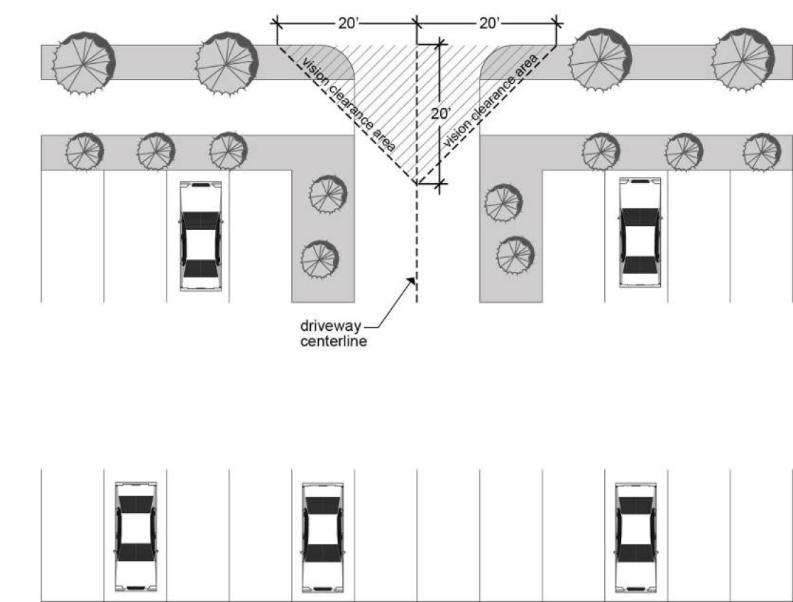
2.
Backing Movements onto a Street Not Permitted. Parking lots larger than 4 spaces shall use an access driveway to prevent backing movements or other maneuvering on a street. Backing movements from larger parking lots are permitted on alleys.
3.
Alley Improvements. If a parking area would directly access an alley, the developer shall be responsible for any necessary improvements to the alley as required by Subsection 12.50.530.B.11. and the Public Works Design and Construction Standards. Required improvements shall be constructed and completed prior to issuance of final certificates of occupancy.
4.
Driveway Consolidation and Parking Area Connection. To reduce congestion on public streets, consolidation of curb cuts and/or connection of parking fields in new non-residential developments on adjacent sites may be required. To meet this standard, provision of reciprocal easements may be a condition of development approval.
C.
Dimensional Requirements for Parking Spaces, Access Aisles and Maneuvering Areas.
1.
Parking areas shall conform to the Americans with Disabilities Act (ADA) standards and guidelines for parking spaces (dimensions, van accessible parking spaces, vertical clearances in parking structures, etc.).
2.
Except as provided in paragraphs 3 through 5 below, minimum dimensions and configurations for parking spaces, access aisles and maneuvering areas are shown in Figure 12.50.360-B.
3.
Up to 50% of the provided number of off-street vehicle parking spaces may be constructed as compact spaces, with minimum dimensions of 16 feet depth and 8 feet width. Compact parking space depths may be reduced not more than 1½ feet adjacent to landscaped strips and pedestrian walkways.
4.
As an alternative to the parking space dimensions in Figure 12.50.360(B), the Review Authority may approve universal parking space dimensions. Minimum dimensions for universal parking spaces shall be 17 feet, 6 inches in depth and 8 feet, 9 inches in width, with a minimum 25-foot wide clear access aisle width. If universal parking space dimensions are approved, compact parking spaces as described in paragraph 3 above shall not be included unless approved by the Review Authority to accommodate physical or structural site limitations. Universal parking space depths may be reduced not more than 1½ feet adjacent to landscaped strips and pedestrian walkways.
5.
As an alternative to the drive aisle widths in Figure 12.50.360(B), the Review Authority may approve 22-foot drive aisle widths in parking structures.
Figure 12.50.360-B:
Minimum Dimensions for Parking Spaces, Access Aisles and Maneuvering Areas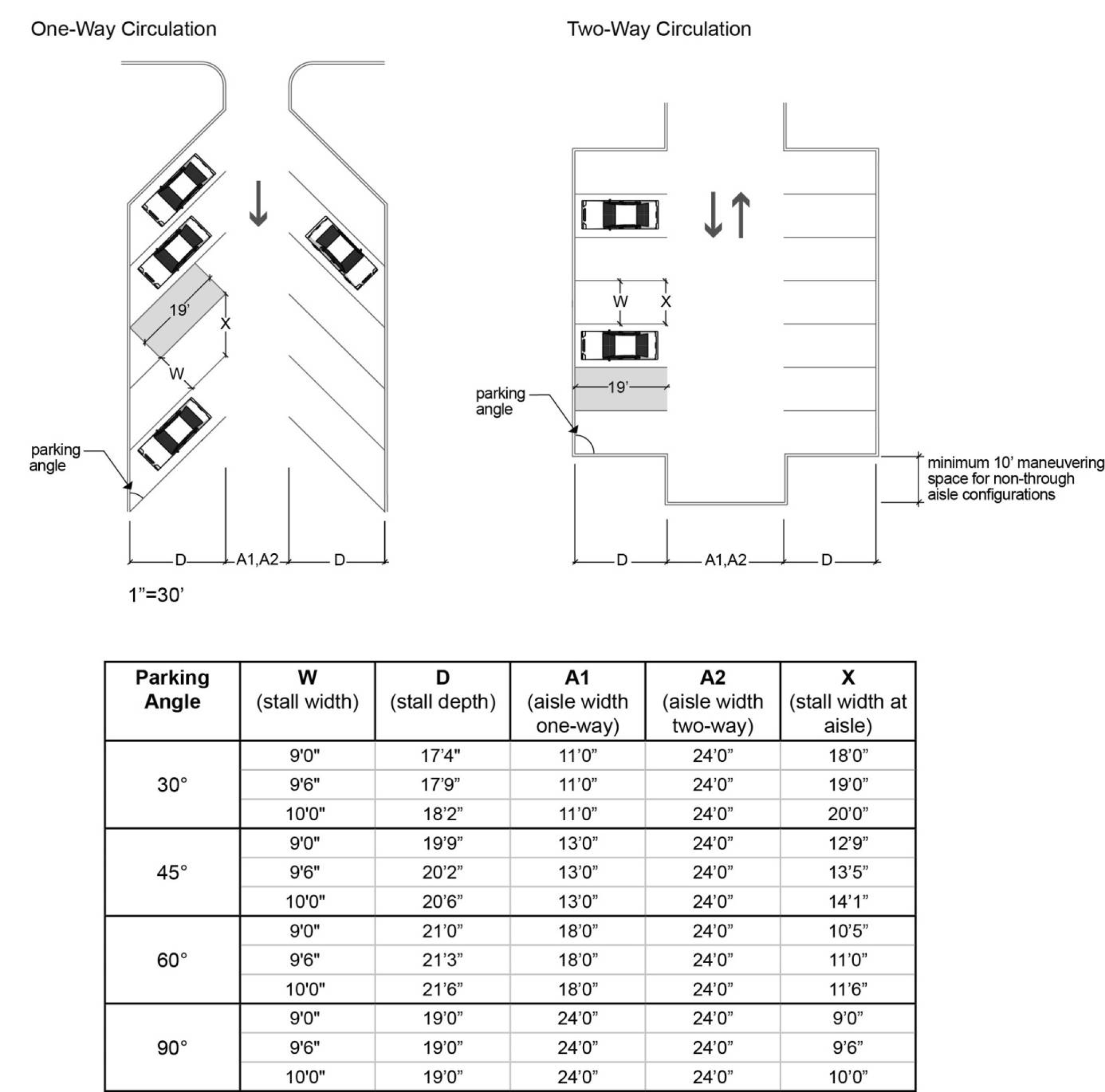
6.
Wheel Stop Requirements. To prevent vehicle overhang from angled or perpendicular parking onto adjacent landscaping or walkways, or across a property line, 1 or more of the following improvements shall be installed at the perimeter of a parking lot or common parking area as shown on Figure 12.50.360-C:
a.
Wheel stops within each parking space, at least 4 inches high and 6 feet long, located 18 inches from the landscaped area or walkway and placed perpendicular to the length of the space; or
b.
A continuous bumper rail, wall or fence at the end of the parking spaces adjacent to the walkway or landscaped area; or
c.
An additional 18 inches of walkway width adjacent to the parking spaces, to maintain a clear 5 feet of unobstructed walkway adjacent to the parking spaces.
Figure 12.50.360-C:
Wheel Stop Locations at Parking Lot Perimeters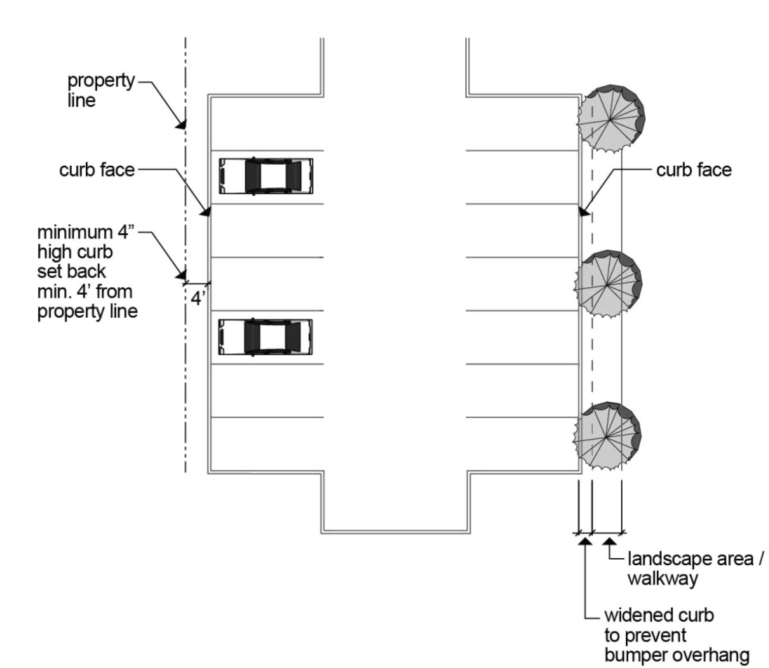
D.
Parking Structure Design in MU-C Zones. For development projects which include structured parking to increase maximum building footprint (pursuant to Subsection 12.24.250.B.) or to increase building height (pursuant to Subsection 12.24.250.C. and Subsection 12.50.140.E.4.), the structured parking shall include the following Uses:
1.
For projects with street frontage on Arterial or Collector streets, the structured parking shall include ground floor residential, commercial or institutional Uses facing the street.
2.
For projects with frontage on local or neighborhood route streets, the structured parking shall be include residential Uses on the ground floor facing the street, or public open space areas, such as small plazas with seating areas, between the building and the street.
3.
If there are multiple parking floors within the parking structure, the upper floors shall be wrapped with office and/or residential Uses or two-story eating and drinking establishments. The area of the roof of the structured parking not occupied by buildings shall provide usable courtyard space, terraces, green roofs and/or community garden plots, which are accessible by the office and residential Uses and/or eating and drinking establishments.
4.
Parking structure entrances shall be constructed at the minimum practicable size and shall be visually integrated into the building elevation by continuing architectural elements such as a frieze, cornice, canopy, overhang, trellis, or decorative grilles from the adjacent façade.
E.
Parking Lot Surface Improvements.
1.
All vehicular parking areas, including parking spaces, access aisles and driveways shall have a durable, dust-free surfacing. Options for surfacing materials include the following, subject to approval by the Review Authority:
a.
Asphaltic Concrete;
b.
Portland Cement;
c.
Pervious surfacing and other low impact development approaches (LIDA) techniques and practices as described in Section 12.64.750 where site conditions are favorable; or
d.
Other suitable materials based on a specified need. The burden of proof is on the applicant to demonstrate the necessity for other suitable materials.
2.
The uses and operations listed below may provide alternative surfacing, such as gravel or other similar semi-pervious surfaces, from the above requirements for vehicular parking or storage areas. The access aisles and driveways shall meet the surfacing requirements listed above.
a.
Major assembly facilities.
i.
Only allowed for spaces provided for peak demand. Parking meeting the above standards shall be provided for average daily traffic, including weekday employees and visitors.
b.
Outdoor storage.
i.
Allowed either as an accessory to a primary use or as a standalone primary use; and
ii.
The vehicular circulation areas within the outdoor storage area may also be semi-pervious. Recreational vehicle and boat storage shall still be required to provide paved drive aisles as described in Section 12.40.220.
c.
Telecommunication facilities
d.
Utility facilities
3.
Parking fields shall be graded toward the site interior, to prevent storm water drainage across or over public sidewalks or onto any abutting public or private property.
F.
Parking Lot Screening and Landscaping.
1.
Applicability. These standards apply to parking lots serving nonresidential uses and common parking areas serving 3 or more dwelling units. In addition to the standards of this section, parking lot landscaping is also subject to the general landscaping requirements of Subsection 12.50.220.B.
2.
General Parking Lot Landscaping Standards.
a.
Coverage. A minimum of 70% of all required parking lot landscaped areas, including required planting strips and planting bays, shall be planted with trees or shrubs and continuous ground cover consisting of lawn, low growing evergreen shrubs, or evergreen ground cover. The percentage measurement in this standard shall be calculated at plant maturity.
b.
Plant Sizes. The minimum planting size for all required trees, shrubs and ground covers in parking lot landscaping shall comply with the standards in Table 12.50.220-1.
3.
Perimeter Landscape/Screening.
a.
Perimeter landscaping or screening shall be provided to meet 1 or more of the following standards:
i.
Planter strips at the width specified in Table 12.50.360-1, planted with large-scale, high canopy, horizontally-branching street tree species. Adjacent to public rights-of-way, tree species in perimeter planter strips shall be selected and planted to be compatible with trees and above- and below-ground utilities in the planter strips or in the public right-of-way. Individual trees shall be spaced between parking spaces to reduce damage from automobiles; and/or
ii.
Planter strips at the width specified in Table 12.50.360-1, planted with an evergreen hedge. Hedges adjacent to public rights-of-way shall be between 30 inches and 42 inches in height; and/or
iii.
A decorative wall or fence 30 to 42 inches in height parallel to and at least 2 feet from the right-of-way line, with landscaping between the wall or fence and the sidewalk consistent with paragraph 2 above.
b.
Perimeter landscaping or screening shall be selected, installed and maintained to preserve sidewalk access and adequate sight distance for vehicles exiting the parking area.
c.
Perimeter landscaping is not required between parking lots sharing common driveways and/or circulation aisles or other traffic areas. Perimeter landscaping may also be reduced or eliminated adjacent to landscaped open space, to transition the open space landscaping into the parking area and afford better access between the parking and the open space.
d.
Non-residential parking and loading areas adjacent to or within residential zones or adjacent to residential uses shall be designed and constructed to reduce impacts on residential uses through installation of a sight obscuring fence at the property line. The fence shall be between 5 and 6 feet in height, except where vision clearance/sight distance triangles are required.
4.
Interior Landscaping.
a.
Surface parking areas shall include interior landscaping meeting the following standards:
i.
Planting Islands. At least one 2½ feet caliper street tree shall be planted in protected islands at the end of each parking row, and at intervals 100 feet or less within the parking rows. Planting islands shall be at least 5 feet wide, with a minimum area of 190 square feet in a double loaded parking row or 95 square feet in a single loaded parking row. The remaining area of each island shall be landscaped consistently with the general standards in paragraph 2 above.
ii.
All Other Areas. Interior landscaping consistent with the general standards in paragraph 2 above shall be installed wherever parking spaces, access aisles, driveways, or pedestrian movements would not be impeded by landscaping.
b.
Maximum Landscaping Percentage Allowed. If compliance with the standard of this section would require that the area of interior parking lot landscaping exceed 10% of the total area of the surface parking lot, the area of required landscaping shall be limited to 10% unless necessary to meet canopy coverage requirements or otherwise requested by the applicant.
c.
Applicable to Other Requirements. All landscaping required under the provisions of this subsection may be applied towards compliance with other applicable landscaping requirements.
5.
Additional Parking Lot Design Requirements
a.
Parking lots greater than ½ acre of new off-street surface parking, as measured based on the perimeter of all new off-street parking spaces, maneuvering lanes, and maneuvering areas, including driveways and drive aisles shall provide the following:
i.
Tree Canopy. Developments shall provide either trees along driveways or a minimum of 30% tree canopy coverage over new parking areas at tree maturity but no more than 15 years after planting. (Developments are not required to provide trees along drive aisles); and one of the following;
ii.
Climate Action Elements.
(A)
Tree canopy covering at least 40% of the new parking lot area at maturity but no more than 15 years after planting; or
(B)
Installation of solar panels with a generation capacity of at least ½ kilowatt per new off-street parking space. Panels may be located anywhere on the property; or
(C)
Payment of at least $1,500.00 per new off-street parking space into a city or county fund dedicated to equitable solar or wind energy development or a fund at the Oregon Department of Energy designated for such purpose; or
(D)
A mixture of these actions the City deems to meet the purpose of this requirement.
iii.
The tree spacing and species planted must be designed to maintain a continuous canopy except when interrupted by driveways, drive aisles, and other site design considerations
iv.
Development of a tree canopy plan under shall be done in coordination with the local electric utility, including pre-design, design, building and maintenance phases.
G.
Parking Lot Construction: Timing and Deferral.
1.
Completion Time for Parking Lot Construction. Except as provided under paragraph 2 below, parking lot improvements, including required landscaping and paving, shall be completed and the area available for use prior to issuance of final Certificate(s) of Occupancy.
2.
Postponement of Parking Lot Construction. A temporary Certificate of Occupancy may be granted by the Building Official if the developer posts a performance bond or equivalent equal to the cost to complete the improvements as estimated by the Building Official. Postponement of parking lot construction under a temporary Certificate of Occupancy shall not exceed 6 months' duration. No extensions of the 6-month postponement shall be approved.
H.
Electric Vehicle Infrastructure Requirements.
1.
New commercial development shall provide electrical service capacity, as defined in ORS 455.417, to serve not less than 20% of all provided vehicle parking spaces.
2.
New multifamily residential buildings with 5 or more residential dwelling units, and new mixed-use buildings consisting of privately owned commercial space and 5 or more residential dwelling units, shall provide of electrical service capacity, as defined in ORS 455.417, to serve 40% of all provided vehicle parking spaces.
(Ord. No. 6488, §§ 1, 2(Exh. A), 12-3-2024; Ord. 6401 § 1, 2022; Ord. 6393 § 1, 2021; Ord. 6322 § 1, 2019; Ord. 6149 § 1, 2015)
12.50.400 - Bicycle Parking/Bicycle and Pedestrian Circulation and Connectivity.
12.50.410 - Bicycle Parking.
A.
Purpose. Standards for bicycle parking encourage bicycle use, help to reduce principal reliance on the automobile, and increase bicyclists' safety and security.
B.
Applicability. Bicycle parking shall be provided in conjunction with all new developments, expansions of existing development or changes of use, except those exempt housing types and uses listed in subsection C below.
C.
Exemptions.
1.
The following housing types are exempt from bicycle parking requirements:
a.
Detached single dwellings, including manufactured dwellings;
b.
Accessory dwelling units;
c.
Live-work dwellings;
d.
Middle housing; and
e.
Any housing units constructed with individual assigned and enclosed garage or carport spaces or storage spaces 80 square feet or larger.
2.
The following uses are exempt from bicycle parking requirements:
a.
Home occupations;
b.
Mobile and/or temporary businesses as defined in Municipal Code Chapter 5.08; and
c.
Expansions of pre-existing commercial, industrial or institutional uses which are less than 50% of the existing net floor area or 3,000 square feet, whichever is less.
D.
Number of Bicycle Parking Spaces Required.
1.
Except as listed in subsection C above, all new development or expansions of existing development shall provide the minimum number of bicycle parking spaces specified in Tables 12.50.410-1 through 12.50.410-5. New free-standing commercial, industrial or institutional Uses requiring vehicle parking shall provide at least 2 bicycle parking spaces. Multiple tenant buildings or developments may consolidate bicycle parking based on the aggregated net square footage, pursuant to Subsection 12.50.410.G.8.
2.
For expansions of existing commercial, industrial or institutional uses larger than 50% of the current net floor area or 3,000 square feet (whichever is less), bicycle parking shall be calculated based on total net square footage rather than the expansion area.
3.
Bicycle parking for changes in use shall be calculated based upon the requirements for the new use.
4.
For any use not specifically mentioned in Tables 12.50.410-1 through 12.50.410-5, bicycle parking requirements shall be the same as for the use which is most similar to the use not specifically mentioned, as determined by the Planning Director pursuant to Section 12.80.050.
E.
Adjustments to Number of Bicycle Parking Spaces. The Review Authority may adjust minimum bicycle parking provided for changes of Use or expansions of an existing use under Subsection 12.80.156.D.8.
Note: Minimum 2 spaces required for all free-standing Uses: See Subsection 12.50.410.D.1.
Note: Minimum 2 spaces required for all free-standing Uses: See Subsection 12.50.410.D.1.
* As determined by the Building Official.
Note: Minimum 2 spaces required for all free-standing Uses: See Subsection 12.50.410.D.1.
F.
Bicycle Parking Location.
1.
Bicycle parking shall be located on site in secure and accessible locations near a main building entrance.
2.
Outdoor bicycle parking shall be visible from on-site buildings or the street. Indoor bicycle parking for non-residential uses shall be located on the first floor. Indoor bicycle parking may be allowed on any floor in multi-story residential structures.
3.
If required, bicycle parking location(s) shall be shown on the off-street vehicle parking and loading plans submitted to the Review Authority.
G.
Bicycle Parking: Improvements.
1.
Space Size. Spaces shall be at least 6 feet long and 2½ feet wide. An access aisle at least 5 feet wide shall be provided and maintained beside or between each row of parking. Each required space shall be accessible without moving another bicycle.
2.
Security. Secure parking shall be provided as either a lockable storage enclosure or a stationary rack to which bicycles can be locked. All racks, lockers or other facilities shall be securely anchored to the ground or to a structure. Racks shall be designed so that every bicycle can be locked by the frame and secured to prevent falling or wheel damage.
3.
Separation Required. Bicycle parking shall be separated from motor vehicle parking and maneuvering areas by a barrier or a distance of at least 5 feet.
4.
Connectivity Required. Outside bicycle parking shall be connected to each building's main building entrance by pedestrian accessible walkways. Outside bicycle parking also shall have reasonably direct hard-surfaced connections to public rights-of-way and to existing and proposed pedestrian/bicycle accessways.
5.
Signage. Required parking shall be signed and reserved for bicycle parking only. If a bicycle parking area is not plainly visible from the main building entrance, a directional sign shall be posted at the building entrance indicating the location of the bicycle parking area.
6.
Sidewalk Obstruction Not Permitted. Bicycle parking shall not obstruct required minimum widths of sidewalks or pedestrian connections. As part of a Type II or III review, the Review Authority may allow bicycle parking on the public sidewalk only in locations where it would not obstruct required minimum widths or conflict with access to doorways.
7.
Landscaping or Usable Open Space Occupancy Not Permitted. Bicycle parking shall not occupy curbside landscape strips, landscape buffers or required usable open space.
8.
Distribution between Buildings. Bicycle parking may be distributed as the Review Authority determines appropriate as part of a Type II or III review to serve multiple buildings in a development. If a building has 2 or more main building entrances, the Review Authority may require bicycle parking to be located to serve all main building entrances.
9.
Coverage Required/Encouraged. Coverage or shelter is encouraged for all required bicycle parking. If more than 20 bicycle parking spaces are required, at least 25% of the spaces shall be covered or enclosed. If covered, the overhead clearance shall be at least 7 feet. Coverage can be provided through roof extensions, overhangs, awnings, arcades, carports or enclosures. Similar means of coverage can be approved through a Type II or III review. Covered parking can also be provided within a parking structure, garage, or bicycle locker, under a separate roof, or in a designated area within a building or residential complex.
10.
Security at Transit Stations. At transit transfer stations and park-and-ride lots, at least 20% of the required spaces shall be lockers and at least 50% of the remaining required spaces shall be covered or enclosed.
(Ord. No. 6488, §§ 1, 2(Exh. A), 12-3-2024; Ord. 6401 § 1, 2022; Ord. 6323 § 1, 2019; Ord. 6322 § 1, 2019; Ord. 6294 § 1, 2019)
12.50.420 - Pedestrian and Bicycle Circulation.
A.
Purpose. On-site and off-site pedestrian and bicycle circulation standards are intended to provide connections which minimize out-of-direction travel between buildings and existing public rights-of-way, pedestrian/bicycle accessways and other on-site pedestrian facilities.
B.
Applicability. Except as provided in subsection C below, the standards of this section shall apply to all Type II, Type III, and new development projects that include more than ½ acre of new off-street surface parking on a lot or parcel.
C.
Exceptions and Exemptions.
1.
Certain Land Use Applications Exempt. The following land use applications are exempt from the requirements of this section:
a.
Development Review or land division applications for single detached or middle housing developments;
b.
Floodplain Activities;
c.
Significant Natural Resource Permits; and
d.
Cultural Resource Alterations.
2.
Certain Land Uses Exempt. The following land Uses are exempt from the requirements of this section:
a.
Car washes
b.
Commercial parking facilities, except commercial parking structures within 400 feet of a proposed or existing transit station
c.
Golf courses
d.
Greenhouses
e.
Heavy equipment sales
f.
Manufactured home sales
g.
Vehicle service and repair Uses without associated convenience stores, except retail or wholesale Uses selling parts and accessories without on-site installation
h.
Vehicle sales, leasing, rental or storage
i.
Solid waste transfer stations
j.
Truck stops
D.
Standards — On-Site Facilities.
1.
Connections Required. New development shall provide on-site pedestrian and bicycle circulation systems as follows:
a.
Connecting the new development to abutting residential uses, neighborhood activity centers, usable open space, parking lots, and transit stops;
b.
Connecting the main building entrance of each building to the nearest public sidewalk or walkway leading to a public sidewalk; and
c.
Stubbing accessways to abutting vacant land or to developed land without pedestrian/bicycle connections.
2.
Direct Routing. Pedestrian and bicycle accessways shall be reasonably direct.
3.
Clustering. Where practicable, new commercial, Mixed-Use and office developments shall facilitate on-site pedestrian circulation by clustering buildings and creating separate accessways through the site and parking areas.
4.
ADA Access. On-site pedestrian circulation systems shall include accessways and facilities for handicapped persons, consistent with applicable federal and state requirements, and with emphasis wherever practicable on providing continuous, uninterrupted routes.
5.
Improvements. On-site accessways shall be improved to the following standards:
a.
Accessways shall be hard surfaced, which includes pervious surfacing techniques, well-drained, and at least 5 feet in unobstructed width, except as provided in paragraph b, below.
b.
Accessway width shall be increased to 7 feet if the walkway abuts perpendicular or angled parking spaces unless the spaces are equipped with wheel stops pursuant to Subsection 12.50.360.C.3.
c.
Accessway surface material shall contrast visually with adjoining surfaces.
d.
Where accessways are parallel to and abut a vehicular access aisle, the accessway shall be raised or separated from the access aisle by a raised curb, bollards, landscaping or other physical barriers. Where raised accessways are used, the ends shall be equipped with curb ramps.
6.
On-site pedestrian and bicycle circulation shall minimize pedestrian/vehicle conflicts through any or all of the following measures or their equivalents:
a.
Separating pedestrian accessways through the site and parking areas;
b.
Minimizing accessway crossings of driveways; or
c.
Marking pedestrian crossings with changes in elevation, paving texture, color, or material. Crossing markings shall contrast and clearly delineate the crossing or walkway at any time of day or night and shall be improved consistent with ADA and the Oregon Structural Specialty Code.
E.
Standards — Off-Site Facilities. Off-site pedestrian and bicycle circulation is only required in South Hillsboro per Subsection 12.65.420.B.
(Ord. No. 6488, §§ 1, 2(Exh. A), 12-3-2024; Ord. 6401 § 1, 2022)
12.50.430 - Connectivity and Design Standards at or Near Transit Stops.
A.
Purpose. Major and minor transit stops are defined in Section 12.01.500. Pedestrian improvements at transit stops encourage use of transit, which reduces carbon emissions, improves traffic efficiency on public streets, and provides transportation options for transportation disadvantaged persons. In this section "at a major or minor transit stop" means a property line of the building site is not more than 200 feet from the transit stop. "Near a major or minor transit stop" means a property line of the building site is on an intersecting street not more than 300 feet from the transit stop. Both distances in this section are measured as walked by a pedestrian.
B.
Applicability. The standards of this section shall apply to all Type II and Type III development projects located at or near a transit stop and along a transit street that meet 1 or more of the following:
1.
New multiple dwelling structure; or
2.
New non-residential development; or
3.
Non-residential development that includes more than 1,000 square feet of reconstructed retail, commercial, office, or institutional floor area.
C.
Exceptions. The following land uses are exempt from the standards of this section.
1.
Car washes;
2.
Commercial parking facilities, excluding commercial parking structures within 400 feet of a transit station;
3.
Golf courses;
4.
Greenhouses;
5.
Durable goods sales;
6.
Vehicle service and repair, excluding associated convenience stores and vehicle parts and accessories sales without on-site installation;
7.
Vehicle storage;
8.
Solid waste transfer stations;
9.
Truck stops; and
10.
Any other use located at or near a minor or major transit stop, where access to the transit stop would require crossing a collector street or an arterial street and a pedestrian crossing is not available.
D.
Standards Applicable to Development at or Near Minor Transit Stops.
1.
Applicable development projects at or near a minor transit stop shall provide either a transit stop on-site or a pedestrian connection from the development to the nearest transit stop along the transit street.
2.
Transit stop improvements shall include at least 1 of the following improvements:
a.
A dedicated area within the public right-of-way, or an easement within the site, for a passenger shelter;
b.
An accessible passenger area, compliant with Chapter 11 of the Oregon Structural Specialty Code as adopted by the City;
c.
Lighting;
d.
Passenger seating for at least 3 people; and/or
e.
A passenger shelter as approved by the Transit Agency.
3.
To meet the requirement in paragraph D.1, above, the pedestrian connection must be a continuous, unobstructed, reasonably-direct route between the 2 points that is intended and suitable for pedestrian use. On developed parcels, pedestrian connections shall be hard-surfaced. In parks and natural areas, pedestrian connections may be soft-surfaced pathways.
4.
Required transit stop or connection improvements shall be installed concurrent with development construction.
E.
Standards Applicable to Development at or Near Major Transit Stops. Applicable development projects at or near a major transit stop shall meet the following standards:
1.
Main building entrances for new retail commercial, office and institutional buildings located at or near a major transit stop shall be oriented towards the transit street or the street intersecting the transit street. A building meets this standard if the entrance directly faces the transit street or the intersecting street, or if the entrance is linked to the transit street or the intersecting street by an on-site pedestrian connection.
a.
If the site fronts on more than 1 transit street, or on both a transit street and an intersecting street, the building shall have a main entrance oriented to either:
i.
One of the transit streets;
ii.
The intersecting street; or
iii.
The corner where the 2 transit streets or the transit and the non-transit street intersect.
b.
If the building façade length on the transit street is 300 feet or more, the building shall have 2 or more building entrances facing the transit street. The Review Authority may approve a Minor or Major Adjustment to this standard under Section 12.80.154 or 12.80.156.
2.
Building entrances at or near a major transit stop or facing on a plaza shall have weather protection features to protect pedestrians, including, but not limited to, arcades, roofs, porches, alcoves, porticos and/or awnings. The use of continuous, on-site weather protection features or structures between building entrances and adjacent transit streets, streets intersecting transit streets, or transit stops is encouraged.
3.
New retail, commercial or office buildings located within 30 feet of a transit street, a street intersecting a transit street, or a major transit stop, shall include changes in relief on 35% of their façades facing such a street or transit stop. Such changes in relief may include windows, lobbies, covered pedestrian entrances, display windows, cornices, bases, fluted masonry, combinations of such treatments, or other pedestrian-friendly treatments.
4.
New retail, commercial, office or institutional buildings located at a major transit stop shall provide all of the following transit-supportive improvements:
a.
A plaza at either the major transit stop or at the intersection of the adjacent transit street and an intersecting street;
b.
Locate buildings within 20 feet of the front property line closest to the major transit stop, the transit street or a street intersecting the transit street;
c.
An accessible passenger area, compliant with Chapter 11 of the Oregon Structural Specialty Code as adopted by the City;
d.
A dedicated area within the public right-of-way, or an easement within the site, for a passenger shelter if requested by the transit agency, to the degree which the requested easement has a clear nexus with and is proportional to the scale, intensity and reasonably expected level of transit ridership generated from the building;
e.
Passenger seating or a passenger shelter as approved by the Transit Agency; and
f.
Lighting at the transit stop.
5.
All development shall provide a pedestrian connection between the transit stop and the main building entrance(s) on the site that is continuous, unobstructed, reasonably-direct route between the 2 points that is intended and suitable for pedestrian use. On developed parcels, pedestrian connections shall be hard-surfaced. In parks and natural areas, pedestrian connections may be soft-surfaced pathways.
6.
Pursuant to subparagraph 4.b, above, if a building is set within 20 feet of the front property line, no off-street parking will be allowed in the front setback. A single vehicle circulation lane may be permitted in the front setback only if no practicable alternative is available and if driveway crossings are provided for pedestrian safety consistent with Subsection 12.50.420.D.5.
7.
Vehicle parking on corner lots at or near a major transit stop shall not be located adjacent to street intersections.
F.
Redevelopment of Parking. Applications for development at or near major transit stops which include surface parking fields larger than 50 spaces shall include a conceptual redevelopment plan indicating how the excess spaces could be redeveloped in the future. Omission of specific redevelopment plans for the excess parking spaces shall not be the basis for denying the application.
(Ord. No. 6488, §§ 1, 2(Exh. A), 12-3-2024; Ord. 6401 § 1, 2022; Ord. 6322 § 1, 2019; Ord. 6250 § 1, 2017; Ord. 6149 § 1, 2015; Ord. 6120 § 1, 2015)
12.50.500 - Access and Street Standards.
Access and street standards include the following sections:
12.50.510 Purpose, Applicability and Exceptions
12.50.520 Street Connectivity and Access
12.50.530 Public Streets and Alleys Design and Improvement
12.50.540 Private Streets: Design and Improvement
12.50.550 Sidewalk Widths; Design and Location
12.50.560 Street Trees
(Ord. 6401 § 1, 2022)
12.50.510 - Purpose, Applicability and Exceptions.
A.
Purpose. Comprehensive Plan Section 20 Transportation calls for development of a city street system that meets several goals: safety; multi-modality; trip reduction; congestion management; efficient freight movement; livability; and accessibility. The standards in this section are intended to implement these goals by establishing requirements for street improvements in and adjacent to land use developments which will generate the users of and demand for this street system.
B.
Applicability.
1.
These standards apply to all Zoning Review applications, Non-Temporary Emergency Shelter applications, Type II and Type III land use applications, and Expedited and Middle Housing Land Divisions on sites adjacent to existing public streets and/or developments which are required to provide new public or Private streets, alleys or common driveways. In addition to these standards, the City has also adopted Public Works Design and Construction Standards (D & C Standards) that apply to public improvement constructed within the City. The D & C Standards provide detailed construction requirements consistent with this Code.
2.
These standards may require any or all of the following:
a.
Dedication of right-of-way adequate to meet the requirements of the Transportation System Plan (TSP); the D & C Standards; or the requirements of Subchapters 12.60 through 12.67 in certain plan districts;
b.
Street improvements on interior street systems and adjacent existing streets, adequate to meet the requirements of the TSP; the D & C Standards; or the requirements of Subchapters 12.60 through 12.67 in certain plan districts;
c.
Payment of a fee-in-lieu of construction pursuant to the D & C Standards, at the direction of the City Engineer; and/or
d.
Execution of acceptable financial guarantees for improvements deferred at the direction of the City Engineer; and/or
e.
Execution of waivers of remonstrance against improvements deferred at the direction of the City Engineer. Required waivers of remonstrance shall be recorded by the City, and shall be effective for 10 years following the date of execution.
C.
Exceptions.
1.
On County roads or State highways, the road standards of those jurisdictions supersede these requirements.
2.
Where the D & C Standards are more specific than the standards in this section, those standards apply.
3.
The standards of this section shall not be enforced as a condition of approval on new applications for single detached or middle housing residential building permits unless a previous applicable land use approval provides otherwise.
4.
The standards of this section may be modified by the City Engineer upon finding that the otherwise required right-of-way dedications and/or street improvements would not meet applicable legal requirements with respect to the scale or scope of the approved land use development.
(Ord. 6401 § 1, 2022; Ord. 6322 § 1, 2019; Ord. 6250 § 1, 2017; Ord. 6110 § 7, 2015)
12.50.520 - Street Connectivity and Access.
A.
Applicability. The standards of this section apply to:
1.
Any Type II or Type III development that results in the construction of a street;
2.
A land division that is not a Middle Housing Land Division and that:
a.
Is located on a site that is 1.75 acres or larger in size; or
b.
Abuts a parcel upon which there is a street that has been "stubbed" to the proposed development site.
B.
Through Street Connectivity Required.
1.
Applicable development shall provide a street system that meets the block length standards in subsections B or C, as applicable, and provides access to the following:
a.
Abutting residential developments;
b.
Abutting undeveloped property; and
c.
Abutting neighborhood activity centers.
2.
The following factors shall be considered in establishing location, grade and width of new internal streets:
a.
Connections to existing streets as required in subsection C below;
b.
Topographical conditions and natural resource corridors;
c.
Existing and identified future transit routes and pedestrian/bicycle accessways; and
d.
The proposed use of land to be served by the streets.
3.
Intersection angles, grades, tangents and curves proposed for the internal street system shall be consistent with the D & C Standards.
C.
Street Connectivity and Block Length Requirements in Standard Zones.
1.
New internal streets within a development shall connect to all existing or planned stubbed streets that abut the site.
2.
Unless exempted under Subsection C.3 below, full street connections spaced not more than 530 feet apart shall be provided in all contiguous vacant and/or underdeveloped sites 5 gross acres or larger planned or zoned for residential or mixed-use development.
3.
Full street connections are not required where barriers prevent their construction or require different street connection spacing; in such cases, pedestrian and bicycle connections shall be provided as described in subsection D below. Such barriers include the following:
a.
Topography;
b.
Railroad right-of-way;
c.
Freeway right-of-way;
d.
Pre-existing development patterns;
e.
Streams, wetlands or waterways regulated under Metro UGM Functional Plan Title 3; and/or
f.
Significant Natural Resources regulated under Section 12.27.200.
4.
Except where precluded by the barriers listed in subsection C.3, above, maximum block lengths between local and collector streets shall be 1,000 feet, and the maximum perimeter of blocks formed by local and collector streets shall be 2,750 feet.
5.
Within ½ mile of existing neighborhood activity centers or transit stops, maximum block lengths shall be 600 feet, and the maximum perimeter of blocks formed by local and collector streets shall be 1,800 feet.
6.
Where the connectivity analysis indicates that larger block lengths or perimeters within a proposed development would deter pedestrian and bicycle travel, the Review Authority may require construction of additional pedestrian accessways within such blocks where appropriate.
D.
Street Connectivity and Block Length Requirements in Light Rail and Mixed-Use Zones.
1.
On sites meeting either of the following criteria, new internal streets and alleys shall be configured in a grid connecting to existing or planned streets:
a.
Vacant or underdeveloped sites 3.7 gross acres or larger; or
b.
Sites where existing or planned streets and alleys are stubbed to the perimeter property line.
2.
Unless precluded by barriers as described in subsection C.3, above, blocks in undeveloped areas shall include alleys consistent with the proposed street grid to allow use of rear-loaded garages and accessory dwelling units and to provide access for utility and garbage services.
3.
The street grid system shall be reasonably straight and direct and shall avoid unnecessary curves. Cul-de-sac streets are not permitted unless street continuation is precluded by barriers as described in subsection C.3, above.
4.
In the vicinity of a transit station or major transit stop, streets and alleys shall be laid out to provide direct and continuous routes to the transit station or stop, or to a street in an adjacent development.
5.
Maximum block perimeter lengths created by the street and alley pattern shall be 1,600 feet.
E.
Connectivity Standards for Pedestrian and Bicycle Accessways Where Through Streets Are Not Feasible. Pedestrian accessways shall meet the standards listed below. Accessways used as secondary fire access or utility corridors shall also meet the additional standards in subsection F, below.
1.
Accessways shall be created within public rights-of-way, public tracts, or private tracts with public access easements. Such rights-of-way, tracts, or easements shall be at least 15 feet wide.
2.
Accessway entry points shall align with pedestrian crossing points on abutting streets and with abutting street intersections.
3.
Accessways shall not exceed 300 feet in length between streets.
4.
Accessways shall be sufficiently straight that both end points are visible from any point on the accessway.
5.
Accessways shall have no horizontal obstructions and a 9-foot, 6-inch high vertical clearance. Additional clearance shall be provided on secondary fire accessways as required in subsection F below.
6.
Accessway surface improvements shall be at least 10 feet in width. Improvements shall be impervious pavement (asphalt or concrete), unless pervious pavement has been approved by the Review Authority and the City Engineer based on usage and site conditions.
7.
Accessway surfaces shall drain stormwater runoff to the side or sides. Paving materials, storm drainage, shoulder treatment, and landscaping for accessways are subject to approval by the City Engineer and the Planning Director.
8.
Accessways shall be lighted as required in Section 12.50.240. Lighting shall be installed at both end points and may also be required at intermediate points as determined by the City Engineer. Lighting on accessways shall be shielded to minimize glare and unnecessary diffusion into the sky and onto neighboring properties, especially into significant natural resource areas.
9.
Accessways shall have a slope of 5% or less.
10.
Accessways shall be fenced and screened along adjacent property with 1 or both of the following improvements:
a.
A minimum 5-foot high fence. To meet this standard, wooden fences must be built of pressure-treated structural members with a pressure treated cap rail; and/or
b.
A thick vegetation screen of evergreen shrubs or climbers planted either adjacent to a new fence meeting the standard in subsection a, above, or to an existing private fence on the adjacent property. To meet this standard, evergreen plant species must be low maintenance varieties, capable of 42 inches height within 3 years of planting without irrigation. Native species are encouraged; nuisance species are Not Permitted. Evergreen species with mature heights taller than 4 feet shall be avoided. Plant species and spacing are subject to approval by the Review Authority.
11.
To prohibit access by motorized vehicles (except motorized wheelchairs) accessways shall be constructed with gates, removable lockable posts, bollards or barriers as approved by the Fire Department.
F.
Additional Standards for Accessways Used as Secondary Fire Access or Utility Corridor. In addition to the standards in subsection E, above, accessways that also serve as secondary emergency vehicle accesses or utility corridors shall meet the following additional standards:
1.
The accessway shall have at least 13 feet 6 inches (13′6″) vertical clearance or other clearance as approved by the Fire Marshal.
2.
The accessway shall have a minimum 20-foot paved surface within a 20-foot wide right-of-way, tract, or easement. Reduced width secondary fire access accessways may be proposed subject to approval by the City Engineer and the Fire Marshal.
3.
Pervious pavement may be permitted by the Review Authority, subject to approval by the City Engineer and the Fire Marshal.
G.
Ownership, Liability and Maintenance of Accessways. To ensure accessway maintenance over time, a maintenance agreement shall be recorded that specifically requires present and future property owners to provide for liability and maintenance of the accessways to City standards.
(Ord. 6401 § 1, 2022; Ord. 6323 § 1, 2019; Ord. 6322 § 1, 2019; Ord. 6120 § 1, 2015)
12.50.530 - Public Streets and Alleys Design and Improvement.
A.
General Standards and Requirements.
1.
The Review Authority shall condition approvals of land use applications adjacent to existing public streets and/or required to provide new public streets or alleys to provide adequate right-of-way and improvements to streets, sidewalks, bike routes and bikeways, consistent with the TSP, the Public Works Development and Construction (D & C) Standards, and Transportation Committee policy.
2.
The Review Authority shall also consider future needs for street widening and other transportation improvements in the vicinity of the proposed development that would mitigate traffic impacts generated by the proposed development. The Review Authority may require off-site improvements, including, but not limited to: lighting; signalization; turn lanes; medians; on-street parking; traffic islands; paving; curbs and gutters; sidewalks; bikeways; storm drainage systems; or facilities needed due to the anticipated vehicular and pedestrian traffic generation from the proposed development.
3.
Narrower designs for local streets may be permitted with City Engineer approval. Reduced width street designs shall comply with applicable D & C Standards.
4.
Where site conditions are favorable to stormwater infiltration, "green street" designs are encouraged and may be used. In these cases, deviation from the street standards in this Code or in the D & C Standards may be approved by the City Engineer. Design elements and facilities which require City Engineer approval for use in the public right-of-way include, but are not limited to, the following:
a.
Increased numbers of street trees;
b.
Vegetated islands within street improvements;
c.
Reduced improvement widths at stream crossings; and/or
d.
Multi-functional open storm drainage in lieu of conventional curb-and-gutter systems.
5.
Except as provided under paragraph 6 below, public utility easements (PUEs) for public and private underground utilities (including gas, electric, telephone and cable communications conduits or duct banks) shall be provided adjacent to all public rights-of-way. The width of the PUEs shall be subject to approval by the City Engineer.
6.
If private utilities cannot be located in a PUE due to setbacks, the City Engineer may permit placement in the public right-of-way under the provisions of a City franchise agreement.
7.
All street sections, curbs, gutters, sidewalks, street lights and street trees shall be constructed and installed consistent with the D & C Standards unless alternative plan district standards are specified in Subchapters 12.60 through 12.67.
B.
Street Classifications and Improvements in Standard Zones.
1.
Consistency with TSPs. The street descriptions in this section reflect and implement the street classifications on the TSP Functional Classification Map. Traffic capacity volumes within each classification provide an order of magnitude distinction between classifications, and are generally consistent with the Washington County Transportation Plan. "Improvement width" as specified in the classification description includes: required travel lanes and curb and gutter components; additional median improvements (landscaped and/or left turn lane); bicycle lanes; on-street parking spaces; and stormwater quality measures as permitted or required in a land use approval.
2.
Applicability to Public Streets. These standards apply to streets which are or will be dedicated to the City. Developers may choose to construct private streets at a lesser standard pursuant to Section 12.50.540.
3.
Functional Capacity Retained. The street standards contained in this section may be varied with City Engineer approval, but the functional classification, projected volumes and bike path plan must be accommodated in the variation. However, adjacent to properties designated and/or zoned mixed-use, standards for street sections may be adjusted to provide on-street parking, increased sidewalk width, or to substitute bicycle lanes and bicycle ways on street sections with reduced traffic speeds.
4.
Arterial Streets. Arterial streets are the primary routes for travel between Hillsboro and other areas in the region, between major areas of urban activity, and to access the highway system. Arterial streets vary in width from 2 lanes to 7 lanes: Arterial street widths are shown in the Design and Construction Standards.
a.
If additional left and/or right turn lanes are required as a result of the Traffic Impact Analysis pursuant to Section 12.70.220, additional right-of-way shall be required as a condition of development approval.
b.
On certain streets in plan districts as specified in Subchapters 12.60 through 12.67, sidewalks shall be constructed to increased widths, such as 8 feet, 12 feet, or wider. If approved by the City Engineer, additional right-of-way or sidewalk easements shall be required on these streets to accommodate the additional sidewalk width.
c.
Property access points to arterial streets between intersections are subject to approval by the Road Authority, and may be conditioned to limitations such as right turn only configuration, consolidation among adjacent properties, and minimum spacing standards to reduce traffic conflicts on the arterial street.
5.
Collector Streets. Collector streets provide both circulation within and access to residential and commercial/industrial areas. Although some collector streets may carry the same traffic levels as arterial streets, collectors may differ functionally from arterials in several respects: entering residential neighborhoods; distributing trips from neighborhood routes and local streets; providing a portion of City-wide circulation; and not having access controls as strict as those for arterials.
a.
Certain collector streets identified in the TSP shall be constructed to a larger capacity.
b.
Left turn lanes in collector streets shall be constructed at major intersections and may be required if approved by the City Engineer at authorized property access points between intersections.
6.
Neighborhood Routes. Neighborhood routes provide connectivity between local streets and collectors or arterials, and are generally longer and carry more traffic than local residential streets. To retain neighborhood character and livability, the Review Authority may condition development approvals on neighborhood routes to require any of the following neighborhood traffic management measures, as described in the Transportation System Plan:
a.
Speed humps;
b.
On-street parking;
c.
Traffic circles;
d.
Medians;
e.
Landscaping;
f.
Curb extensions (bulb-outs);
g.
Narrower streets; and/or
h.
Chokers (which narrow roadways at selected locations).
7.
Local Roads. Local roads serve abutting land only. Right-of-way and improvement requirements vary with projected vehicles per day (VPD) as specified in the D & C Standards.
a.
Local roads should carry less than 1,500 vehicles per day. If projected VPD is more than 1,500 vehicles, the Review Authority may require use of neighborhood traffic management measures as listed in paragraph 6, above, on the street.
b.
Narrower local street rights-of-way may be permitted with City Engineer approval if minimum dimensional requirements are met for travel lanes, bike lanes, parking lanes and sidewalk widths.
c.
To improve public safety, reduce traffic hazards and promote safety for residents, pedestrians, and bicyclists, and upon recommendation by the City Engineer, the Review Authority may require that local streets be constructed to discourage use by non-local automobile traffic.
8.
Cul-de-Sac Streets. These streets shall serve not more than 25 dwelling units and should not be longer than 200 feet except as specified under subparagraph a, below.
a.
With City Engineer approval, a cul-de-sac street may exceed 200 feet in length where the barriers listed in Subsection 12.50.520.C.4. prevent street extension outside the site. However, if the City Engineer finds there is potential for future connectivity to adjacent vacant property, design and construction of the development and the cul-de-sac shall meet the following standards:
i.
The lotting pattern in the development shall be designed to not preclude future extension of the street;
ii.
Street improvements for the cul-de-sac shall not include a permanent turning area; and
iii.
Public right-of-way shall be dedicated from the current cul-de-sac terminus to the edge of the development to allow future extension of the street.
b.
Pursuant to Subsection 12.50.520.B.2, an applicant for a development including cul-de-sac streets shall make a good faith effort to construct pedestrian and bicycle accessway connections to neighboring properties from the end of the cul-de-sacs.
c.
If construction of the accessways in subparagraph b above is not technically or economically feasible at the time of land use approval, the Review Authority may require any or all of the following as a condition of the development approval if the City Engineer finds that a pedestrian-bicycle connection may be feasible in the future:
i.
Lotting patterns and siting of buildings which do not preclude possible future connectivity;
ii.
Provision of a public easement compliant with Subsection 12.50.430.D. or 12.50.430.E. as applicable, from the cul-de-sac to the property line of the adjacent lot; and/or
iii.
Construction or payment of fee in lieu for the segment of the connection within the development.
9.
Commercial and Industrial Streets. Commercial and industrial streets are intended to serve primarily abutting non-residential land uses and are not through routes. Due to the nature of the adjacent land uses, traffic will include larger trucks requiring wider travel lanes and additional turning radii.
10.
Mixed-Use Streets. Mixed-use streets are located within or adjacent to neighborhoods designated and/or zoned mixed-use on the Comprehensive Plan and Zoning Map. Mixed-use streets may be local residential or neighborhood streets, collectors, or arterial streets within or adjacent to these neighborhoods. Mixed-use developments may be subject to additional base zone standards as listed in Subchapter 12.24, including variations to the street standards listed in the TSP. Where special plan district street standards are included in Subchapters 12.60 through 12.67, those standards supersede both the TSP and the D & C Standards regarding street design and structural cross-sections.
a.
To encourage pedestrian activity and access and increased density of development in mixed-use neighborhoods, the Review Authority may modify mixed-use street sections to provide on-street parking, increase sidewalk width, reduce travel lane width, and/or add bicycle lanes or bicycle ways.
b.
Modified mixed-use street configurations may be conditioned by the Review Authority to encourage reduced traffic speeds.
11.
Public Alleys. Alleys serve abutting properties only, and are intended primarily as secondary access for parking and service uses.
a.
Development projects within the plan districts listed in Subchapters 12.60 through 12.67 shall improve existing adjacent existing alleys or dedicate and improve new alleys as required by the plan district standards.
b.
Public alleys may be approved in development projects outside plan districts. Where approved, the maximum service area and length shall meet D & C Standards.
C.
Street Classifications and Improvements in Light Rail Zones. New streets shall be designed to accommodate traffic volumes and characteristics of the surrounding land uses, including demand for on-street parking. Street cross-sections and right-of-way widths in light rail zones may be varied from the D & C Standards with City Engineer approval if the specifications in paragraphs 1 and 2 below are met.
1.
Local and Neighborhood Route Street Standards. Local and Neighborhood Route streets shall be improved to the specifications in Table 12.50.530-1:
a.
Bicycle Lanes. Bicycle lanes are required on both sides of a neighborhood route street, but are not required on local streets.
b.
On-street Parking. On-street parking is required on at least 1 side of a street adjacent to residential development unless additional visitor parking is provided within the development. If on-street parking is not provided, the street adjacent to the site shall be signed to prohibit parking.
2.
Collector and Arterial Streets Standards. Collector and arterial streets shall be improved to the specifications shown in Table 12.50.130-1, with the following exceptions:
a.
Collector streets shall have a 3-lane section: 2 travel lanes at least 10 feet wide and a center median or left turn lane at least 11 feet wide. The length of the left turn lane shall be based on the recommendation of a Traffic Impact Analysis (TIA) pursuant to Section 12.70.220, and shall be subject to approval by the City Engineer.
b.
Collector and arterial streets designated or planned as transit streets shall have wider curbside lanes: at least 12 feet wide. The widths of other transit street components within the right-of-way shall not be reduced to compensate for this increased width, and the Review Authority may require additional right-of-way to accommodate the increased width.
c.
Collector and arterial streets shall have on-street bicycle lanes in both travel directions.
d.
The Review Authority may require traffic calming measures on any street within a light rail zone, consistent with Subsection 12.50.530.B.6, and the recommendations of the TIA.
e.
Arterial street components shall be sized and constructed in compliance with the D & C Standards and the TIA. If the Standards and the TIA conflict with specific provisions of this Code, the provisions of this Code shall prevail.
f.
Collector and arterial street intersections controlled by traffic signals shall provide additional sidewalk area at the intersection sufficient to meet AASHTO Urban Street Pedestrian Queuing Area Level of Service "D" (7 square feet/person). If the street is 3 or more lanes, a center median pedestrian refuge area shall be included in the street design and improvement, sufficient to meet AASHTO Urban Street Pedestrian Queuing Area Level of Service "C" (10 square feet/person). Queuing area size shall be determined based on estimated pedestrian traffic from the TIA.
3.
Street Lighting and Furniture. Except as provided under paragraph 5 below, street lighting and furniture installed in the public right-of-way within 1,300 feet of an HCT station shall be either the same as those installed under the original light rail transit project; or as approved by the Review Authority. Street lighting and furniture subject to this standard include the following:
a.
Streetlight poles and fixtures
b.
Bicycle racks
c.
Benches
d.
Street tree grates
e.
Trash receptacles
f.
Street and sidewalk surface patterns and materials
g.
Street signage
4.
Additional Lighting on Arterial and Collector Streets. The City Engineer may require street lighting on arterial and collector streets to have higher illumination or different poles and fixtures. The City Engineer may require ornamental street lighting to be supplemented by the minimum necessary number of standard luminaires mounted on poles matching as closely as practicable the ornamental streetlight poles.
5.
Pedestrian Use Street Design in Light Rail Zones. In light rail residential zones and in the SCC-SC zone, streets extending from light rail stations should be designed to allow use by pedestrian-friendly retail and service uses, recreation and social activities.
D.
Street Improvements in Mixed-Use Zones. In addition to the standards in subsections A and B, above, developments in mixed-use zones adjacent to public streets shall install the following improvements:
1.
Ornamental street lights (as identified in the D & C Standards) with any required public street improvement; and
2.
Curb extensions (bulb-outs) at public street intersections with any required public street improvement. The design of the bulb-outs shall be subject to approval by the Planning Director and City Engineer.
(Ord. 6401 § 1, 2022; Ord. 6322 § 1, 2019; Ord. 6258 § 1, 2018; Ord. 6110 § 7, 2015)
12.50.540 - Private Streets: Design and Improvement.
A.
Applicability. These standards apply to all land divisions and development projects which include or will be required to provide private streets.
B.
Specifications and Standards.
1.
Use of Private Streets Restricted. The City's preferred standard for access is a public street. Private through streets are not permitted under all circumstances. Private cul-de-sac streets may be approved only under the limited circumstances listed below:
a.
Where barriers to connectivity, as listed in Subsection 12.50.520.B.4, prevent construction of public through streets; and
b.
Where construction of a non-standard street cross-section (not consistent with the Public Works Design and Construction Standards) has been approved by the City Engineer; and
c.
Where both permanent ownership and maintenance of the private street tract for a minimum of 40 years have been demonstrated to the satisfaction of the City Engineer and the City Attorney.
2.
Private Cul-de-Sac Street Standards. If permitted, private cul-de-sac streets shall be constructed to the reduced width cul-de-sac standards in the Public Works Design and Construction Standards.
(Ord. 6401 § 1, 2022; Ord. 6322 § 1, 2019; Ord. 6120 § 1, 2015)
12.50.550 - Sidewalk Widths: Design and Location.
A.
Applicability. These standards apply to all Type II and III development projects and land divisions adjacent to public and private streets, which include or will be required to provide sidewalks.
B.
General Sidewalk Standards.
1.
The Review Authority shall condition approvals of land use applications adjacent to existing public streets, and/or required to provide new public or Private streets, to provide sidewalks consistent with the TSP and the D & C Standards, unless modified or alternative improvements are approved by the Review Authority or are specified in the plan districts listed in Subchapters 12.60 through 12.67.
2.
Sidewalks are required on both sides of public streets and both sides of private streets longer than 100 feet. The Review Authority may reduce sidewalk requirements on a public or private street to 1 side of the frontage to reduce impacts in Significant Natural Resource Areas or Habitat Benefit Areas or where physical or topographic features encourage reduced width street improvements.
3.
Except as provided in subsection C below, sidewalk widths, design and location on public streets shall comply with the D & C Standards sidewalk widths. Sidewalk locations on private streets shall comply with Table 12.50.540-2.
4.
Sidewalks on public and private streets shall be constructed to the D & C specifications.
5.
Clear sidewalk widths shall not be reduced below 5 feet to accommodate sidewalk obstacles. If such an obstacle could reduce the clear sidewalk width to less than 5 feet, the obstacle shall be placed either in the landscape strip or on the property behind the back edge of the sidewalk, or the sidewalk shall be widened to maintain the minimum 5-foot clear width. As used in this section, sidewalk obstacles may include any of the following or similar objects:
a.
Pedestrian benches;
b.
Trash or recycling receptacles;
c.
Street light poles;
d.
Fire hydrants;
e.
Traffic signals;
f.
Parking meters;
g.
Telephone booths;
h.
Newspaper boxes;
i.
Public utility vaults;
j.
Mailboxes;
k.
Vending stands or carts;
l.
Temporary signs.
6.
In light rail zones, if existing public right-of-way cannot accommodate required sidewalks and landscape strips, additional right-of-way dedications or easements shall be provided to the City prior to the issuance of building permits for the subject development, except as provided under paragraph 7 below.
7.
In light rail zones, where the façade of an existing building is less than 13 feet from the curb face, and a proposed redevelopment or remodeling would not move the façade from its current position, the dedication or easement required under paragraph 5, above, may be reduced upon approval by the City Engineer and the Building Official to the minimum width permitted under the Building Code.
C.
Alternative Sidewalk Standards.
1.
Alternative sidewalk widths, design and location standards in certain plan districts are specified in Subchapters 12.60 through 12.67, with alternative sidewalk width, design and location standards include the following:
a.
Downtown;
b.
Fair Complex/Hawthorn Farm;
c.
Orenco;
d.
Amberglen;
e.
South Hillsboro; and
f.
Witch Hazel Village.
2.
New development on NE John Olsen Ave. and NE Quatama St. shall construct 8-foot sidewalks, with at least 4-foot planter strips along the street frontages as shown on Figure 12.50.550-A. Sidewalks on streets not shown on Figure 12.50.550-A shall meet the width requirements of the Public Works Design and Construction Standards.
3.
The Review Authority may approve alternative sidewalk elements under a PUD application process pursuant to Section 12.80.120. Alternative sidewalk elements shall also be subject to approval by the City Engineer.
Figure 12.50.550-A:
Sidewalk Requirements for Quatama St/John Olsen Ave
(Ord. 6401 § 1, 2022; Ord. 6322 § 1, 2019; Ord. 6110 § 7, 2015)
12.50.560 - Street Trees.
A.
Applicability. These standards apply to all Type II and III development applications and land divisions adjacent to public streets for which street and/or sidewalk improvements have been required under Section 12.50.550.
B.
Standards. The following standards apply to street tree selection, installation and maintenance unless alternative standards are specified in Subchapter 12.60.
1.
The Review Authority shall condition land use approvals, including requirements for street and/or sidewalk improvements in public rights-of-way, to select, install and maintain street trees and irrigation systems in compliance with the D & C Standards.
2.
As required by the D & C Standards, approval of land use applications including street tree installation shall be conditioned to require provision of acceptable financial assurances to ensure compliance with the applicable standards.
3.
Following the 2-year establishment period, maintenance, pruning, and if necessary removal and replacement of street trees shall comply with the provisions of the D & C Standards.
(Ord. 6401 § 1, 2022)
12.50.600 - Public Utilities, Site Grading and Storm Water Management Facilities Site Integration.
Public utilities general requirements, site grading, and storm water facilities site integration standards include the following sections:
12.50.610 Purpose, Applicability and Exceptions
12.50.620 Public Utilities General Requirements
12.50.625 Power and Communications Utility Undergrounding
12.50.630 Site Grading
12.50.640 Storm Water Facilities Site Integration
(Ord. 6401 § 1, 2022)
12.50.610 - Purpose, Applicability and Exceptions.
A.
Purpose. Comprehensive Plan Section 15 Public Facilities and Services requires that development is appropriately guided and supported by the provision of public facilities and services in a timely, orderly and efficient manner. These standards set out a framework to assure that proposed development provides for the design, construction and maintenance of the necessary public facilities.
B.
Applicability. Except as may be specified otherwise in this section, these standards apply to all development projects requiring installation of public utilities on site, adjacent, or off site to the project.
(Ord. 6401 § 1, 2022; Ord. 6322 § 1, 2019; Ord. 6261 § 1, 2018; Ord. 6250 § 1, 2017)
12.50.620 - Public Utilities General Requirements.
A.
General Standards.
1.
Adequate Utilities Required. The Review Authority shall condition a land use application approval to require provision of public water, sanitary sewer, communications, and storm drainage service adequate to serve the approved level of development in a manner that is consistent with Section 12.50.620.A.2. It is the applicant's burden of proof to demonstrate that adequate facilities and services are presently available or will be made available concurrent with development. The Review Authority may condition a development approval to extend, modify or replace an existing off-site public water, sanitary sewer, communications, or storm drainage facility or system to provide adequate public facilities or services in a manner that is consistent with Section 12.50.620.A.2. to the development site.
2.
Compliance with Other Standards. Construction of all public water, sanitary sewer, communications, and storm drainage facilities and services shall comply with the D & C Standards, CWS standards or TVWD standards as applicable.
3.
Service Provider Letters Presumed Correct. Service providers shall be presumed correct in the evidence which they submit relating to the adequacy and availability of facilities and services to the development.
B.
Public Utility Easements.
1.
A land division approved under Section 12.80.090 shall be conditioned to require public utility easements (PUEs) for private utilities as approved by the City Engineer, consistent with the D & C Standards.
2.
The Review Authority may condition approval of any Type I, Type II or Type III land use application, Zoning Review applications, and ELD Preliminary Plat applications to provide PUEs as approved by the City Engineer, consistent with the D & C Standards.
3.
PUEs required under paragraphs 1 and 2 above shall be provided to and accepted by the City upon recording of a final plat or prior to occupancy if a final plat is not required. A required easement width specified in the D & C Standards may be reduced only with approval of the City Engineer, Building and Water Departments, and all affected utilities.
C.
Undergrounding Public Utilities.
1.
Except as specified in Section 12.50.625, all public utility distribution and service connections shall be underground.
D.
Maintaining Angle of Repose.
1.
Preliminary applications for developments proposing front setbacks less than 10 feet shall include utility plans showing horizontal and vertical locations of public and private utilities to demonstrate adequate angles of repose.
2.
To assure that structural footprints are sited to provide adequate area for installation and maintenance of public and private utilities in compliance with City standards, the Review Authority may condition land use approvals to require additional setbacks or easement widths to assure adequate separation of utilities before and after construction.
3.
Where additional setbacks or easements cannot be provided or acquired without significantly affecting the project design or reducing the buildable area, the Building Official may allow modifications to a structural foundation footing to reduce the angle of repose influence on an adjacent public utility easement.
E.
Utility Equipment in Urban Areas.
1.
Location. Utility equipment in the following zones shall be located either within an underground vault or shall be screened and spaced as required by Subsections E.2 and E.3:
a.
SCC-DT Station Community Commercial — Downtown.
b.
Within the Orenco Town Center Plan District: SCC-SC Station Community Commercial — Station Commercial and SCR-V Station Community Residential — Village.
c.
All zones within the Amberglen Plan District.
d.
All zones within the Tanasbourne Town Center Plan.
e.
Within the South Hillsboro Plan District: along Active Use Streets 1 and 2 in the MU-VTC Mixed Use — Village Town Center.
2.
Spacing. Above ground utility equipment shall be located away from the sidewalk with sufficient space to allow a minimum of 10 feet of clearance between the screening for the utility equipment and any paved surfaces including public and private streets, driveways, and walkways in such a way that safety and system reliability is not compromised.
3.
Screening. One or more of the following methods of screening shall be required for above ground utility equipment:
a.
Low walls that are a minimum of 6 inches taller than the vents, access doors, or utility equipment to be screened, and which are architecturally treated to match the other on-site walls and covered with vines with a minimum size of 5 gallons, spaced 10 feet on center or as otherwise approved by the Review Authority. Walls shall comply with all applicable zoning requirements.
b.
Landscaping that, upon installation, shall screen a minimum of 75% of the vents, access doors, or utility equipment from view.
c.
Artificial "rock" equipment that covers 100% of the utility equipment. These should be accented with natural boulders and landscaping.
d.
Locating the utility equipment within a building, as permitted by regulations.
e.
Locating the utility equipment in an alley or on the rear of the project.
f.
Any other screening option that may be available due to unique site or building design characteristics and that complies with Section 12.50.620.A.2.
(Ord. 6437 § 1, 2023; Ord. 6401 § 1, 2022; Ord. 6322 § 1, 2019; Ord. 6261 § 1, 2018)
12.50.625 - Power and Communications Utility Undergrounding.
A.
Purpose. To require the undergrounding of all above ground electric power lines and co-located communication lines along the site's frontage, and to include service connections to on-site development, in order to improve public safety, the reliability of service during and after storms, and streetscape aesthetics.
B.
Applicability.
1.
The standards in this Section 12.60.625 apply to new and existing utility lines that operate below 35,000 volts.
2.
Exemptions. Applicants are not required to underground existing electric power lines and other co-located communication lines or pay fee-in-lieu (FIL) of undergrounding these utilities in the following situations:
a.
The site is already fully in compliance with the requirements of this Section 12.50.625;
b.
The project is the result of damages caused by natural disaster (e.g., earthquake, flood, etc.) which is outside the influence of the property owner and/or applicant;
c.
The application is for one of the following:
i.
Minor partition in a middle housing zone (per Table 12.01.200-1),
ii.
Single detached dwelling, accessory dwelling unit, or middle housing development,
iii.
Type I review,
iv.
Expansion of existing multi-dwelling residential, commercial or mixed use buildings which increase existing floor area by less than 10% or 5,000 square feet, whichever is less. Cumulative expansions that increase floor area over 10% are not exempt,
v.
Expansion of existing industrial buildings which increase existing floor area by less than 15% or 5,000 square feet, whichever is less. Cumulative expansions that increase floor area over 15% are not exempt.
3.
Type A Projects. Type A projects are projects that are not exempt, but which meet one of the criteria below. Type A projects are subject to the standards of Subsection C.
a.
The site has less than 100 feet of street frontage with existing above ground electric power lines that is subject to the undergrounding requirement;
b.
Undergrounding the existing above ground electric power lines would not result in a decrease in the number of electric utility poles. The change in the number of utility poles shall be based on an estimate provided by the electric power franchise.
4.
Type B Projects. Except for capital improvement projects which are subject to the City of Hillsboro's Capital Improvement Plan and Type A projects which are subject to the standards of Subsection C, all other projects are considered Type B projects and are subject to the standards in Subsection D.
C.
Standards Applicable to Type A Projects.
1.
All above ground electric power lines and co-located communication lines along the site's frontage and related service connections to on-site development shall be installed underground unless the applicant opts to pay a FIL in accordance with Paragraph C.3 or D.2.
2.
Electric power lines and co-located communication lines to be installed underground are subject to the installation standards in Subsection E.
3.
Applicants for Type A projects may opt to make a partial payment of the required FIL using the percent of project valuation methodology in this section or pay the full FIL using the methodology in Subsection D.2.
a.
Project valuation shall be determined utilizing valuation tables or through use of an estimate provided by the architect, engineer, or contractor for the project, whichever is higher.
b.
For subdivisions, the FIL shall be paid to the City prior to approval of a final plat. For other projects, the FIL shall be paid to the City prior to the issuance of the first building permit for the project.
c.
The fees shall be deposited in a fund to be used only for undergrounding of utilities in the City and purposes directly related thereto.
d.
If the project valuation estimate is less than the linear foot estimate in Subsection D.2, additional FIL payments up to the full amount required by Subsection D.2 shall be required at the time when the site further develops or redevelops.
D.
Standards Applicable to Type B Projects.
1.
Except where an Adjustment has been approved pursuant to Section 12.80.154 or Section 12.80.156, all above ground electric power lines and co-located communication lines along the site's frontage and related service connections to on-site development shall be placed underground.
2.
If an Adjustment is approved, the applicant shall pay a FIL of undergrounding the utilities.
a.
The FIL shall be based on the City's approved fee schedule.
b.
If a partial fee has already been paid on a site, the fee is reduced by the amount that has previously been paid. If 100% of the fee has been paid on a site, no further fees are due.
c.
For subdivisions, the FIL shall be paid to the City prior to approval of a final plat. For other projects, the FIL shall be paid to the City prior to the issuance of the first building permit for the project.
d.
The fees shall be deposited in a fund to be used only for undergrounding of utilities in the City and purposes directly related thereto.
E.
Installation Standards for the Undergrounding Electric Power Lines and Other Co-Located Communication Lines.
1.
Electric power lines and co-located communication lines shall be undergrounded in the locations listed in Table 12.50.625-1, subject to the approval of the City Engineer.
2.
As an alternative to the locations listed in Table 12.50.625-1, the Review Authority may require utilities to be placed underground within an adjacent alley right-of-way if such right-of-way is available, with vault locations as approved by the City Engineer and the utility provider.
* Vaults cannot be located in ROW or sidewalk.
(Ord. 6437 § 1, 2023)
12.50.630 - Site Grading.
A.
Purpose. The standards of this section are intended to assure that grading prior to or during site development, or independently from development, is planned and accomplished to avoid adverse impacts to adjacent or abutting properties and significant natural resource areas, maintain pedestrian and bicycle connectivity between properties were applicable, and maintain accessibility to public and private utility lines and easements.
B.
Applicability.
1.
The on-site surface contour grading standards specified in this section are applicable to all major and minor site alterations as defined in Section 12.01.500 where site fill or excavation, mass grading or soil stockpiling is proposed.
2.
Pursuant to the requirements of Public Works Design and Construction Standards Section 115.3, a site grading plan is required for any development that involves excavation or fill on public or private property or in public right-of-way. Plans for grading proposed in conjunction with a Type I, Type II or Type III land use application development shall be submitted with the land use applications pursuant to Subchapter 12.80 Applications.
3.
The section does not supersede Section 12.27.100 Regulatory Floodplain Overlay or Section 12.27.200 Significant Natural Resource Overlay: where these standards conflict with those sections, the requirements of those sections supersede.
C.
Exemptions. The following site alterations are exempt from the standards in this section:
1.
Public right-of-way road improvements including new streets, street widening, sidewalks, and similar or related improvements;
2.
Public utility improvements including new water, sanitary sewer, or storm drainage lines, public storm water facilities, and similar or related improvements; and
3.
Filling, excavating, and grading on private properties adjacent to public improvements listed in Paragraphs 1 and/or 2 above, when such alterations are undertaken as part of and in conjunction with the construction of the improvements.
D.
Standards Applicable within and Adjacent to Single Dwelling Residential Zones.
1.
Except as provided in subsection F below, when grading a site within 25 feet of a property line within or abutting any property zoned single dwelling residential (as listed in Section 12.21.010), on-site grading shall be finished to the surface contours shown in Table 12.50.630-1:
2.
Where an existing grade differential before site alteration exceeds 1 or more of the standards in Table 12.50.630-1 above, the grade differential after alteration shall not exceed the original.
3.
The on-site grading differential standards in paragraph 1 above apply only to perimeter property lines of a parent property, and not to internal property lines created by a land division process under Section 12.80.090.
E.
Standards Applicable Adjacent to Significant Natural Resource Areas.
1.
Notwithstanding the requirements of subsections D and E above, grading within 25 feet of a Significant Natural Resource (SNR) boundary or Resource Impact Areas (IA) boundary, whether located on or off site, shall be finished to the following surface contours:
a.
From 0.0 to 10.0 feet from the boundary: no change in pre-development ground elevation; and
b.
From 10.1 feet to 25.0 feet from the boundary: a maximum 10% slope gradient difference from the pre-development ground elevation.
2.
Based on the recommendation of a Qualified Natural Resources Professional as defined in Section 12.01.500, the Review Authority may require additional surface contouring or other grading measures to protect the SNR or IA area from grading or erosion impacts.
F.
Land Use Approval Required for Mass Grading or Site Grading Not Associated with Development. If mass grading or stockpiling as defined in Section 12.01.500 is proposed on public or private property, the site grading plan required under D & C Standards Section 120.4 shall be submitted as a Type II Development Review application pursuant to Section 12.80.040.
(Ord. 6401 § 1, 2022; Ord. 6322 § 1, 2019; Ord. 6258 § 1, 2018)
12.50.640 - Storm Water Facilities Site Integration.
A.
Purpose. The standards of this section are intended to assure that aboveground stormwater facilities are designed and constructed to meet applicable standards in the Public Works Design and Construction Standards and in Clean Water Services (CWS) Construction Standards, and that overall landscape design is integrated with such facilities.
B.
Applicability. The standards specified in this section are applicable to any project which includes aboveground stormwater facilities and meets the definition of "development" in CWS Design and Construction Standards.
C.
Exemptions. Activities exempted from the definition of "development" under CWS Design and Construction Standards are exempt from the provisions of this section.
D.
Standards.
1.
Plans for aboveground stormwater facilities shall be submitted with landscaping plans for land use applications under Subchapter 12.80 Applications. Site improvements in the vicinity of the stormwater facility shall designed and installed to integrate the facility into the site design through coordination of finished grade elevations and use of compatible landscaping species consistent with Section 12.50.220.
2.
The Review Authority may condition any Type II or Type III land use application approval to require that the aboveground stormwater facility complies with the applicable provisions of the 2018 CWS Design and Construction Standards Chapter 3 Sensitive Areas and Vegetated Corridors and Chapter 4 Runoff Treatment and Control.
(Ord. 6401 § 1, 2022; Ord. 6322 § 1, 2019; Ord. 6258 § 1, 2018)
12.50.700 - Design Standards for Residential Development.
12.50.710 - Design Standards for All Residential Development.
A.
Purpose. These design standards are intended to generally assure that new residential development will be compatible with the City's character, while allowing for some flexibility for new development. In addition, the regulations provide certainty to property owners, developers and neighbors regarding allowable design.
B.
Applicability. Except where noted in each subsection, these standards shall apply as follows:
1.
These standards apply to all residential housing types. In addition, Section 12.50.715 applies only to middle housing and Section 12.50.720 applies only to multiple dwelling residential.
2.
When criteria a. and b. below are met, Subsections 12.50.710.C.3. (Foundation Materials), C.4 (Articulation) and C.5 (Detailed Design Elements) do not apply:
a.
The lot was created before July 1, 2022 and is less than 0.25 acres in size; and
b.
The lot is not within a designated plan district.
3.
These standards and the standards of Section 12.50.715 do not apply to middle housing created through conversion of, or addition to, an existing dwelling; however, the conversion or addition shall not increase nonconformance with these standards.
4.
The standards do not apply to accessory structures, detached garages, or carports.
5.
Applicants may request adjustments to these standards and the additional standards in Sections 12.50.715 and 12.50.720 pursuant to Sections 12.80.154 and 12.80.156.
C.
Standards.
1.
Main Entries.
a.
For Housing Types With Shared Entries. In addition to the main entry standards for middle housing and multiple dwelling structures, common main entries shall meet the following standards:
i.
Common main entries for housing types with shared entries shall face the front property line, unless one of the following circumstances applies:
(A)
Buildings on corner lots may have the main entry facing either street or the intersection of the streets.
(B)
Buildings with more than one main entry may have only one entry facing the front property line.
(C)
Building entries that face a landscaped shared courtyard are exempt from this requirement.
b.
For Housing Types With Individual Entries. At least one main entrance to a dwelling unit shall meet both subparagraphs i. and ii., below. These requirements do not apply to entries for ADUs.
i.
The entry shall be no further than 8 feet behind the longest street-facing wall of the building, as illustrated in Figure 12.50.710-A; and
ii.
The entry shall either, face the street, be at an angle of no more than 45 degrees from the street, or open to a porch. If the entry opens to a porch, the porch shall meet all of the following standards:
(A)
Have a minimum area of 25 square feet, with a minimum depth of 5 feet;
(B)
Have at least one porch entry facing the street; and
(C)
Have a roof that is a maximum of 12 feet above the floor of the porch as measured to the lowest element of the roof; and that covers at least 30% of the porch area.
Figure 12.50.710-A:
Main Entrances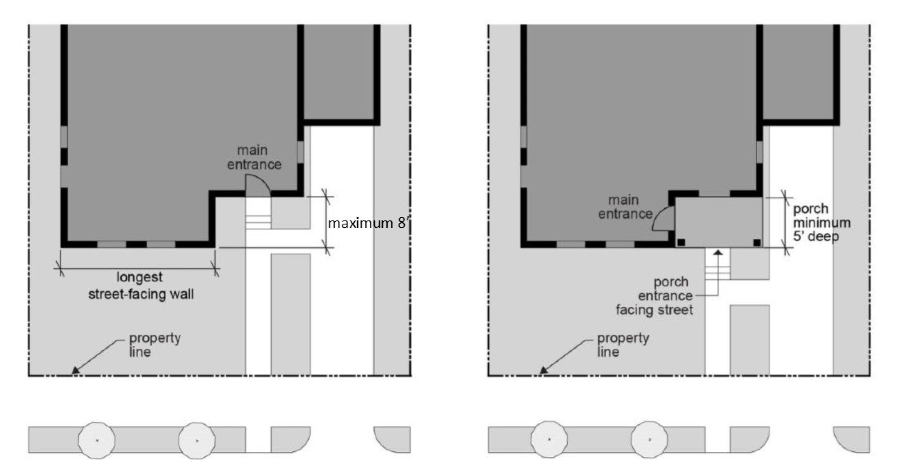
2.
Windows. At least 15% of the area of each façade facing a street or commonly-accessible open space, and 20% of the ground floor facing those 2 features, shall be glazing or entry doors with glazing insets, as illustrated in Figure 12.50.710-B.
a.
Transparent windows allowing views from the dwelling to the street or public open space meet this standard. Up to 25% of the required area may also be met by privacy (translucent) windows, glass blocks, or entry doors with translucent glass.
b.
Window area is considered the entire area within the outer window frame, including any interior window grid.
c.
All of the window area of the street-facing wall(s) of an attached garage, and half of the total window area in the door(s) of an attached garage may be counted toward this standard.
d.
Doors used to meet this standard contain glass and shall face the street or be at an angle of not more than 45 degrees from the street. Security viewing devices ("peepholes") do not by themselves meet this standard.
e.
Door area is considered the portion of the door that moves. Door frames do not count toward this standard.
Figure 12.50.710-B:
Windows and Entry Doors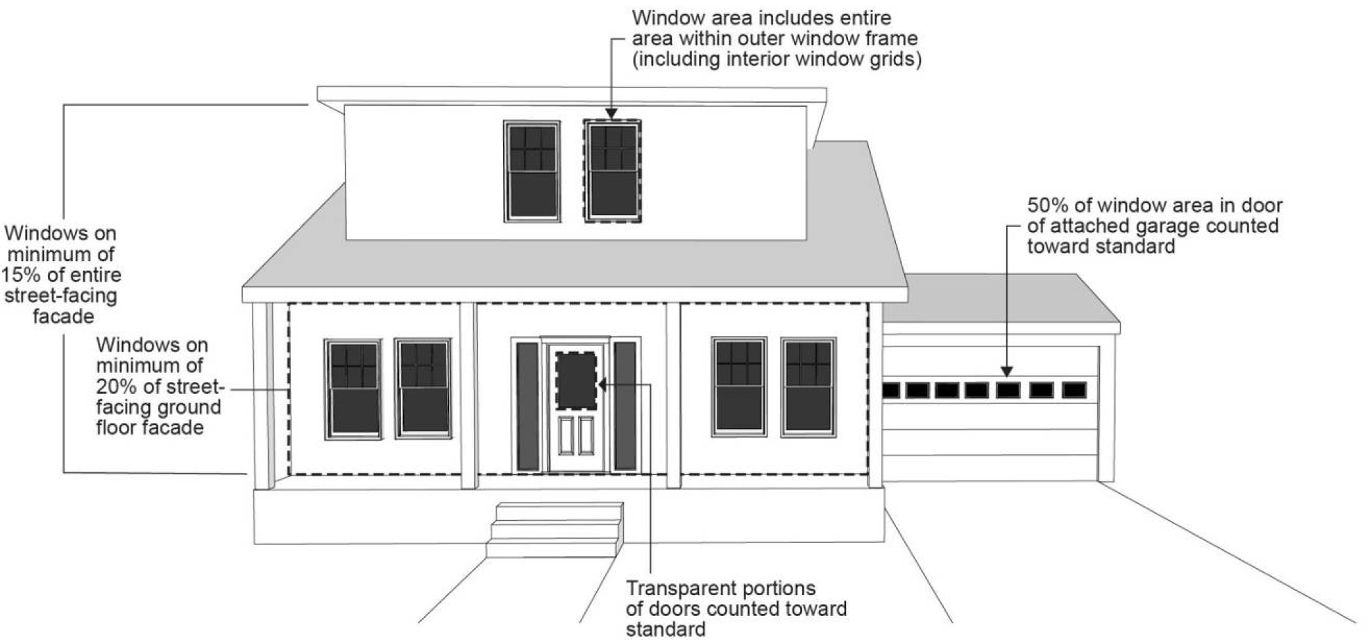
3.
Foundation Materials. Concrete or concrete block may be used as foundation material only if the concrete or concrete block is not exposed above finished grade by more than 3 feet. On sites with slopes greater than 20%, the use of concrete or concrete block as a foundation material may be increased to 6 feet.
4.
Articulation. All residential dwelling structures shall incorporate elements that break up all façades facing streets or commonly-accessible open spaces into smaller planes using 4 or more of the elements listed below, as illustrated in Figure 12.50.710-C. On corner or multi-frontage lots, 4 or more elements shall be provided on each street- or open space-facing façade. Architectural features that meet the standards in this section include the following features:
a.
A covered porch with a minimum depth of 5 feet (measured horizontally from the face of the main façade) and a minimum length of 6 feet;
b.
A balcony at least 4 feet deep and 8 feet wide, that is accessible from one interior room;
c.
A bay window at least 6 feet wide, bumped out by at least 2 feet;
d.
A recessed building entry at least 2 feet deep, as measured horizontally from the face of the main building façade, and at least 5 feet wide;
e.
A section of the façade, at least 6 feet in width, that is either recessed or bumped out by at least 2 feet deep from the front wall plane;
f.
An offset on the building face of at least 16 inches from one exterior wall to the other;
g.
A gabled dormer at least 4 feet wide and integrated into the roof form;
h.
Roof line offset of at least 2 feet from the top surface of one roof to the top surface of the other; or
i.
Other similar architectural features proposed by the applicant if approved by the Review Authority as part of a Type II review.
Figure 12.50.710-C:
Articulation Examples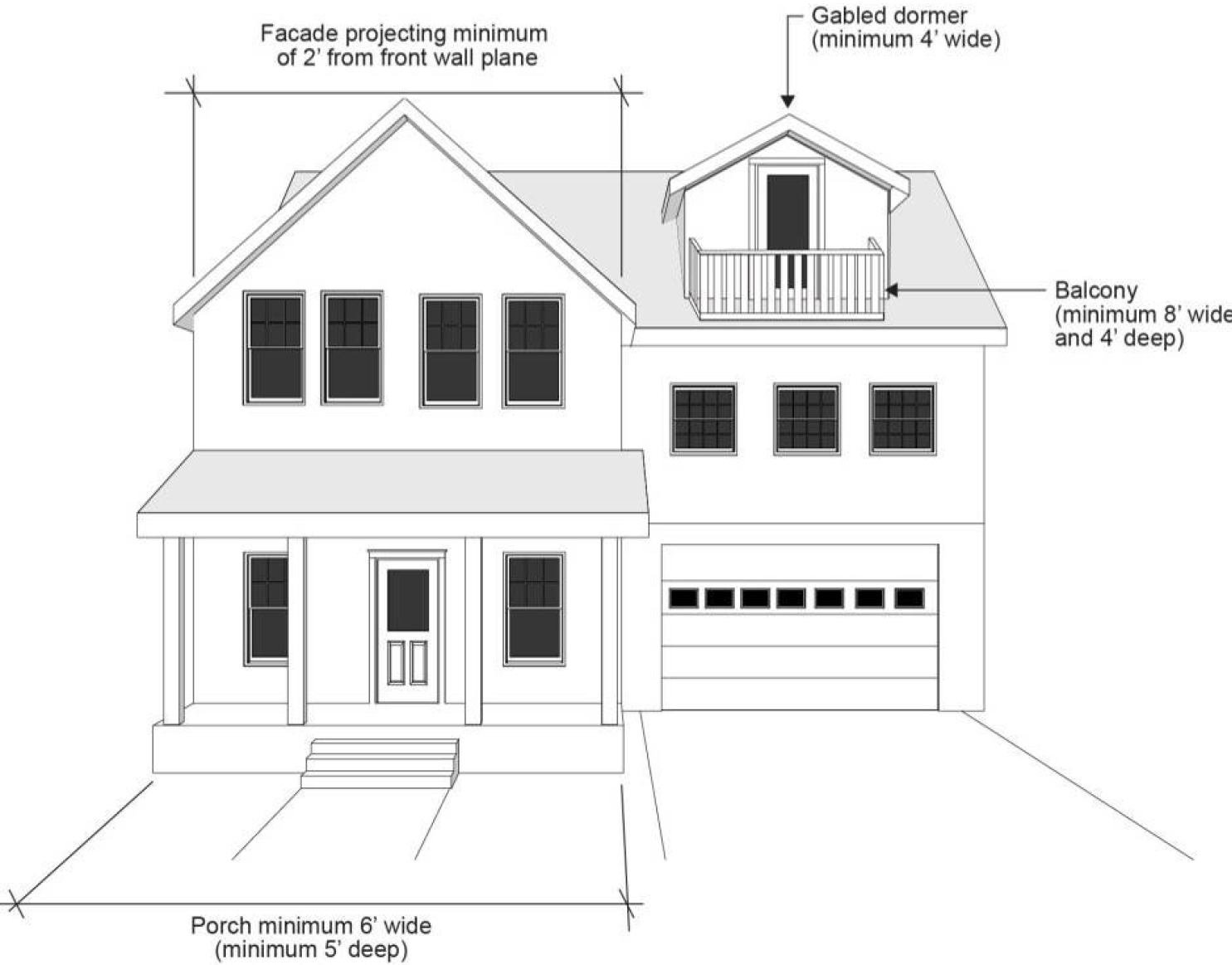
5.
Detailed Design Elements. All residential dwelling structures shall provide at least 9 of the following elements, as illustrated in Figure 12.50.710-D, on any façade facing a street or commonly-accessible open space. On all other façades, at least 4 of the following elements shall be provided:
a.
A recessed building entry at least 2 feet deep, as measured horizontally from the face of the main building façade, and at least 5 feet wide;
b.
Roof eaves on all elevations that project at least 12 inches from the intersection of the roof and the exterior walls;
c.
A minimum of 3 gable end brackets (either triangular knee braces or rake brackets), spaced a maximum of 15 feet on center;
d.
Roof line offset of at least 2 feet from the top surface of one roof to the top surface of the other;
e.
Hip or gambrel roof design with a minimum pitch of 6/12;
f.
Siding in gables which differs from the primary siding type (e.g., shingle siding in gable when primary siding is horizontal lap);
g.
Tile roofs;
h.
Fiber-cement horizontal lap siding between 3 and 7 inches wide (the visible portion once installed);
i.
Exterior finish materials covering at least 40% of the street-facing façade from one or more of the following: brick, fiber-cement shingles, stone, or stucco (this option is not available to be counted towards the minimum number of elements for façades that do not face a street);
j.
Window trim around all windows with a minimum width of 3 inches and a minimum thickness of ⅝ inches;
k.
On any façade not facing a street or commonly-accessible open space, minimum 15% of the area in glazing or entry doors, consistent with subparagraphs C.2.a through e;
l.
Recesses in all windows on a façade facing a street of at least 3 inches as measured horizontally from the face of the façade (this option is not available to be counted towards the minimum number of elements for façades that do not face a street);
m.
Mullions or window grids in all windows on a façade;
n.
Attached garage width, as measured on the inside of the garage door frame, of 35% or less of the width of the street-facing façade;
o.
Horizontal band or barge boards;
p.
Color palette including 4 colors. Colors may be paint or intrinsic to the material (e.g., wood, brick, or stone). One main color shall cover at least 40% of the street-facing façade and each of the other colors shall be used on a minimum of 4 square feet; and/or
q.
Other similar architectural features proposed by the applicant if approved by the Review Authority as part of a Type II review.
Figure 12.50.710-D:
Detailed Design Elements Examples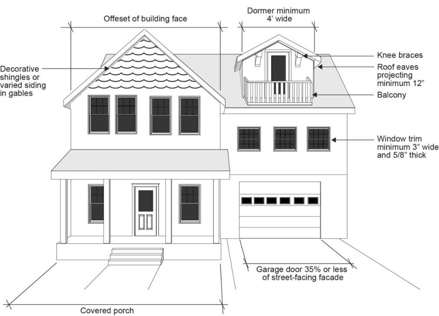
(Ord. 6451 § 1, 2023; Ord. 6401 § 1, 2022; Ord. 6322 § 1, 2019; Ord. 6294 § 1, 2019; Ord. 6178 § 1, 2016)
12.50.715 - Additional Design Standards for Middle Housing.
A.
Purpose. These design standards are intended to generally assure that new middle housing development will be compatible with the City's character, while allowing for some flexibility for new development. In addition, the regulations provide certainty to property owners, developers and neighbors regarding allowable design.
B.
Applicability. Except as specified below, these standards shall apply to all new triplexes, quadplexes, 3 or more unit townhouses, and cottage cluster projects (including accessory structures) in all zones.
C.
Standards for Triplexes and Quadplexes.
1.
Garages and Off-Street Parking Areas. The combined width of all garages and outdoor on-site parking and maneuvering areas shall not exceed a total of 50% of any street frontage (other than an alley), as illustrated in Figure 12.50.715-A.
Figure 12.50.715-A:
Triplex and Quadplex: Width of Garages and Parking Areas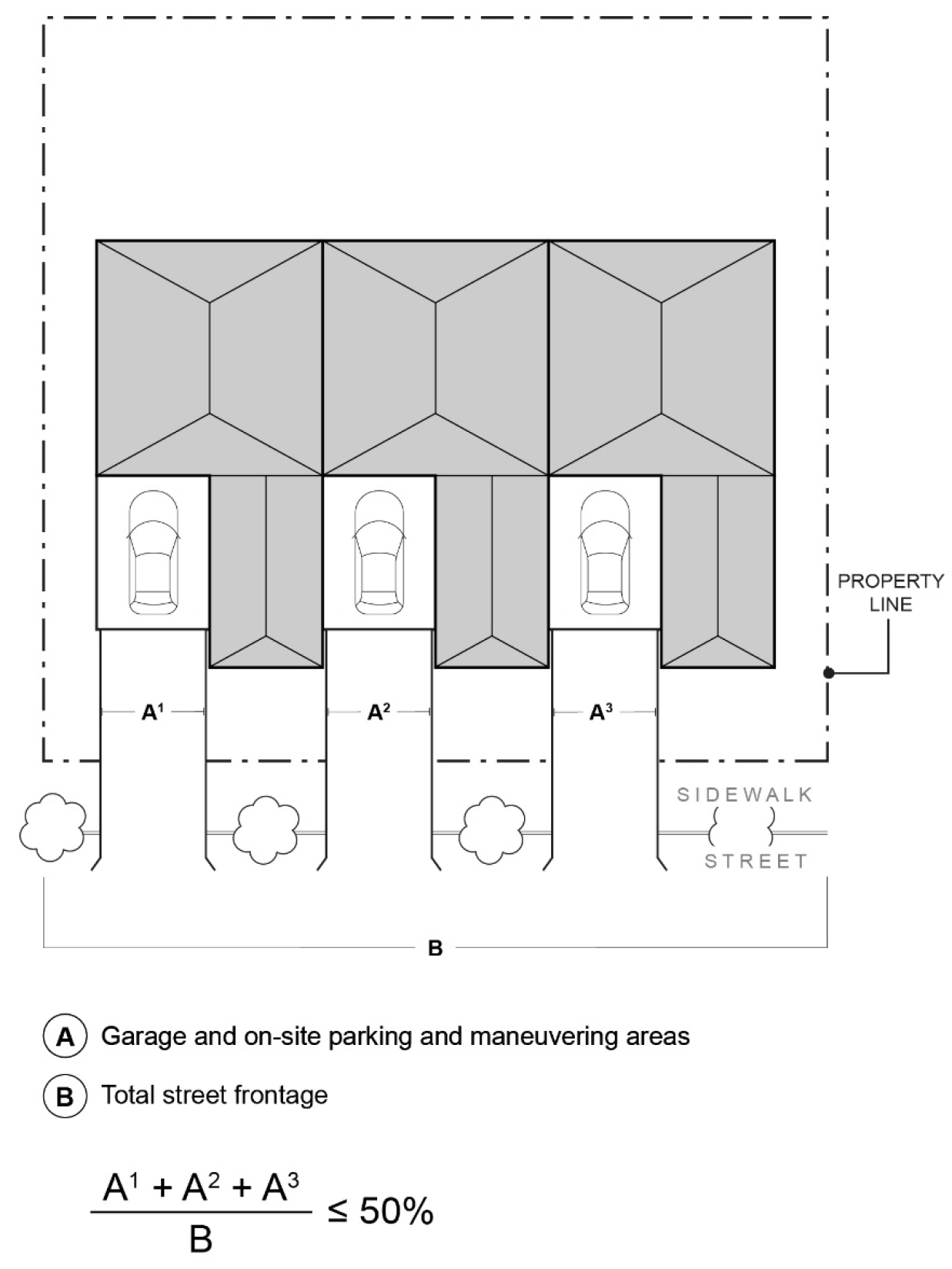
2.
Driveway Approach. Driveway approaches must comply with all of the following:
a.
The total width of all driveway approaches must not exceed 32 feet per frontage, as measured at the property line, as illustrated in Figure 12.50.715-B. For lots or parcels with more than 1 frontage, see subparagraph c.
b.
Driveway approaches may be separated when located on a local street and when spaced according to the requirements of the Hillsboro Design and Construction Standards.
c.
In addition, lots or parcels with more than 1 frontage must comply with the following:
i.
Lots or parcels must access the street with the lowest functional classification for vehicle traffic. For lots or parcels abutting an alley that is improved according to the Hillsboro Design and Construction Standards, access must be taken from the alley, as illustrated in Figure 12.50.715-C.
ii.
Lots or parcels with frontages only on collectors and/or arterial streets shall meet the access spacing standards in the Hillsboro Design and Construction Standards.
iii.
Lots or parcels with frontages only on local streets may have either:
•
Two driveway approaches not exceeding 32 feet in total width on 1 frontage; or
•
One maximum 16-foot-wide driveway approach per frontage, as illustrated in Figure 12.50.715-D.
Figure 12.50.715-B:
Triplex and Quadplex:
Driveway Approach Width and Separation on Local Street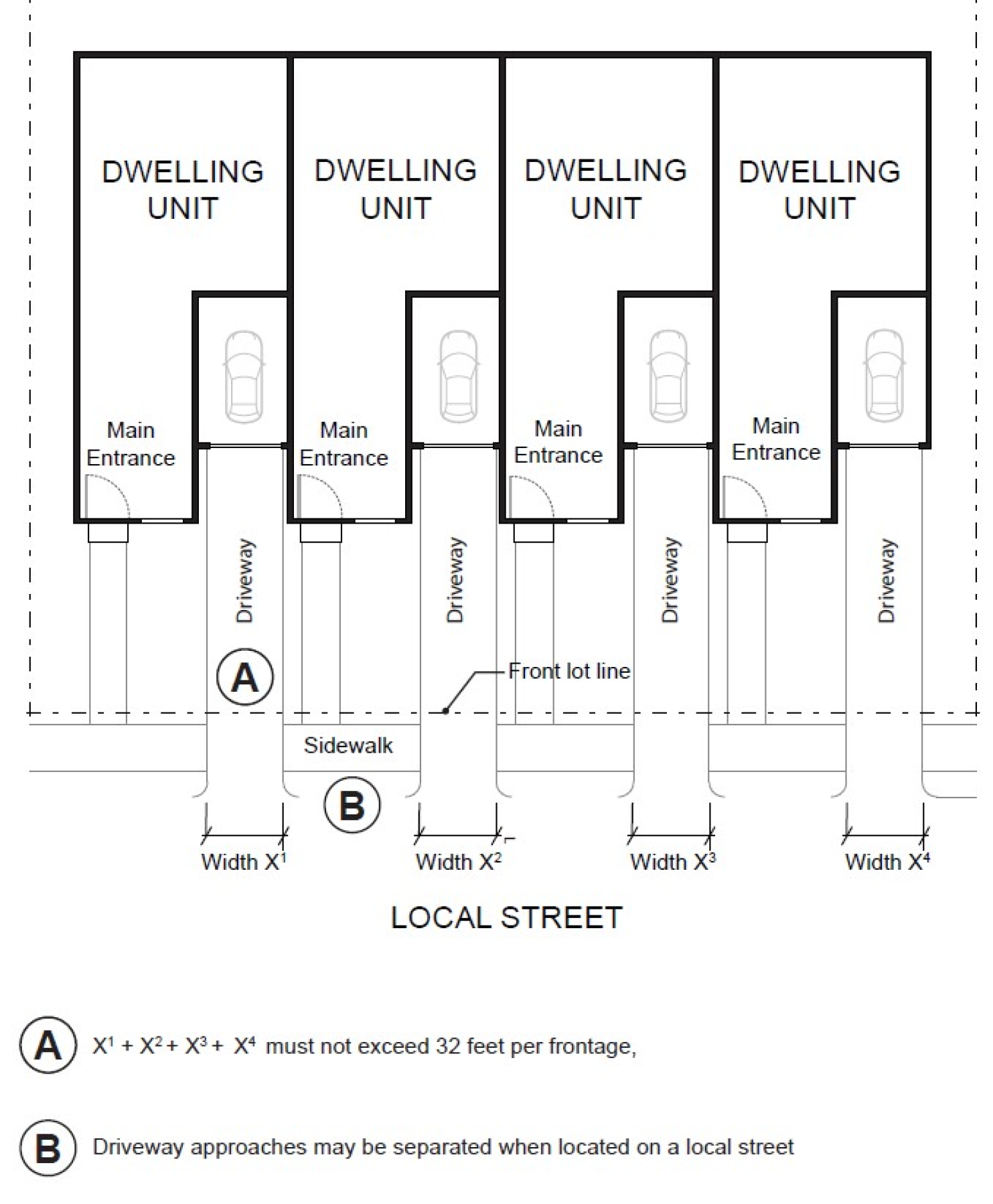
Figure 12.50.715-C:
Triplex and Quadplex: Alley Access
Figure 12.50.715-D:
Triplex and Quadplex:
Driveway Approach Options for Multiple Local Street Frontages
D.
Standards for Three or More Unit Townhouses.
1.
Maximum Number of Attached Dwelling Units. The maximum number of townhouse units that may be attached together to form a group is specified below.
a.
R-10, R-8.5, R-7, R-6, R-4.5, SCR-OTC, and SCR-DNC zones: Maximum of 4 attached units per group.
b.
MR-1, SCR-LD, SCR-MD, MU-N: Maximum of 8 attached units per group.
c.
All other zones where townhouses are permitted: No limit.
2.
Driveway Access and Parking. Townhouses with frontage on a public street shall meet the following standards:
a.
Alley Access. Townhouse project sites abutting an alley that is improved according to the Hillsboro Design and Construction Standards shall take vehicular access from the alley.
b.
Front Access. Garages on the front façade of a townhouse, off-street parking areas in the front yard, and driveways in front of a townhouse are allowed if they meet the following standards:
i.
A maximum of one driveway is allowed for every 2 townhouse units, except that where there is an odd number of townhouse units in a grouping, one driveway may provide access to a single dwelling unit.
ii.
The minimum width for a driveway is 15 feet, except that the minimum width for a single unshared driveway is 10 feet.
iii.
The maximum width for a driveway is 18 feet, except that the maximum width for a single unshared driveway is 12 feet.
iv.
Driveways must be located a minimum of 22 feet apart to minimize vehicle conflicts with pedestrians and to preserve on-street parking. Distance between driveways is measured along the front property line.
c.
The following standards apply to driveways and parking areas for townhouse projects that do not meet all of the standards in subparagraph a. or b.
i.
Off-street parking areas shall be located in the rear yard. No off-street parking shall be allowed in the front yard or side yard of a townhouse.
ii.
A townhouse project that includes a corner lot shall take access from a single driveway approach on the side of the corner lot, as illustrated in Figure 12.50.715-E.
Figure 12.50.715-E:
Townhouses on Corner Lot with Shared Access
iii.
Townhouse projects that do not include a corner lot shall consolidate access for all lots into a single driveway, as illustrated in Figure 12.50.715-F. The driveway and approach are not allowed in the area directly between the front façade and front lot line of any of the townhouses.
Figure 12.50.715-F:
Townhouses with Consolidated Access
iv.
A townhouse project that includes consolidated access or shared driveways shall grant access easements to allow normal vehicular access and emergency access.
3.
Main Entries. In addition to the standards in Section 12.50.710.C.1, main entries for townhouses shall meet the following standards:
a.
In light rail or mixed-use zones, townhouses fronting on a major pedestrian route shall have separate entries directly to the route.
b.
A covered balcony may be substituted for a front porch and shall be approved as a substitute if all of the following standards are met:
i.
The balcony shall be on the same façade as the main entry;
ii.
The balcony shall be accessible from the interior of the house;
iii.
The area covered by the balcony shall be at least 48 square feet in area and at least 8 feet wide; and
iv.
The floor of the balcony is no more than 15 feet above finished grade.
E.
Standards for Cottage Clusters.
1.
Courtyard Required. All cottages within a single cottage cluster must share a common courtyard. A cottage cluster project may include more than 1 cluster and more than 1 common courtyard.
2.
Number of Dwellings.
a.
A single cottage cluster shall contain a minimum of 3 and a maximum of 8 cottages.
b.
A lot shall contain no more than 1 cottage cluster.
c.
Existing residential units shall be counted towards the minimum and maximum cottages allowed.
3.
Building Separation and Setbacks.
a.
Cottages shall be separated by a minimum distance of 6 feet. The minimum distance between all other structures, including accessory structures, shall be in accordance with building code requirements.
b.
All other setbacks are provided in the applicable base zone or plan district.
4.
Building Height. The maximum building height for all structures is 25 feet.
5.
Footprint. The building footprint for each cottage shall be less than 900 square feet. Attached garages up to 200 square feet shall be exempted from the calculation of maximum building footprint.
6.
Floor Area.
a.
Notwithstanding the definition of "floor area" in Section 12.01.500, for the purpose of this section, "floor area" includes the area devoted to private garages.
b.
Floor Area. The maximum permitted floor area of each cottage is 1,550 square feet.
c.
Average Floor Area. The average floor area permitted for a cottage cluster shall not exceed 1,000 square feet per cottage. Community buildings shall be included in the average floor area calculation for a cottage cluster.
7.
Cottage Orientation. Cottages must be clustered around a common courtyard and must meet the following standards, as illustrated in Figure 12.50.715-H:
a.
Each cottage within a cluster must either abut the common courtyard or must be directly connected to it by a pedestrian path.
b.
A minimum of 50% of cottages within a cluster must be oriented to the common courtyard and must:
i.
Have a main entrance facing the common courtyard;
ii.
Be within 10 feet from the common courtyard, measured from the façade of the cottage to the nearest edge of the common courtyard; and
iii.
Be connected to the common courtyard by a pedestrian path.
c.
Cottages within 20 feet of a street property line may have their entrances facing the street.
d.
Cottages not facing the common courtyard or the street must have their main entrances facing a pedestrian path that is connected to the common courtyard.
8.
Common Courtyard Design Standards. Common courtyards must meet the following standards, as illustrated in Figure 12.50.715-G:
a.
The common courtyard must be a single, contiguous piece.
b.
Cottages must abut the common courtyard on at least 2 sides of the courtyard.
c.
The common courtyard must contain a minimum of 150 square feet per cottage within the associated cluster.
d.
The common courtyard must be a minimum of 15 feet wide at its narrowest dimension.
e.
The common courtyard shall be developed with a mix of landscaping, lawn area, pedestrian paths, and/or paved courtyard area, and may also include recreational amenities. Impervious elements of the common courtyard shall not exceed 75% of the total common courtyard area.
f.
Pedestrian paths must be included in a common courtyard. Paths that abut a courtyard shall count toward the courtyard's minimum dimension and area. Parking areas and driveways do not qualify as part of a common courtyard.
Figure 12.50.715-G:
Cottage Cluster Orientation and Common Courtyard Standards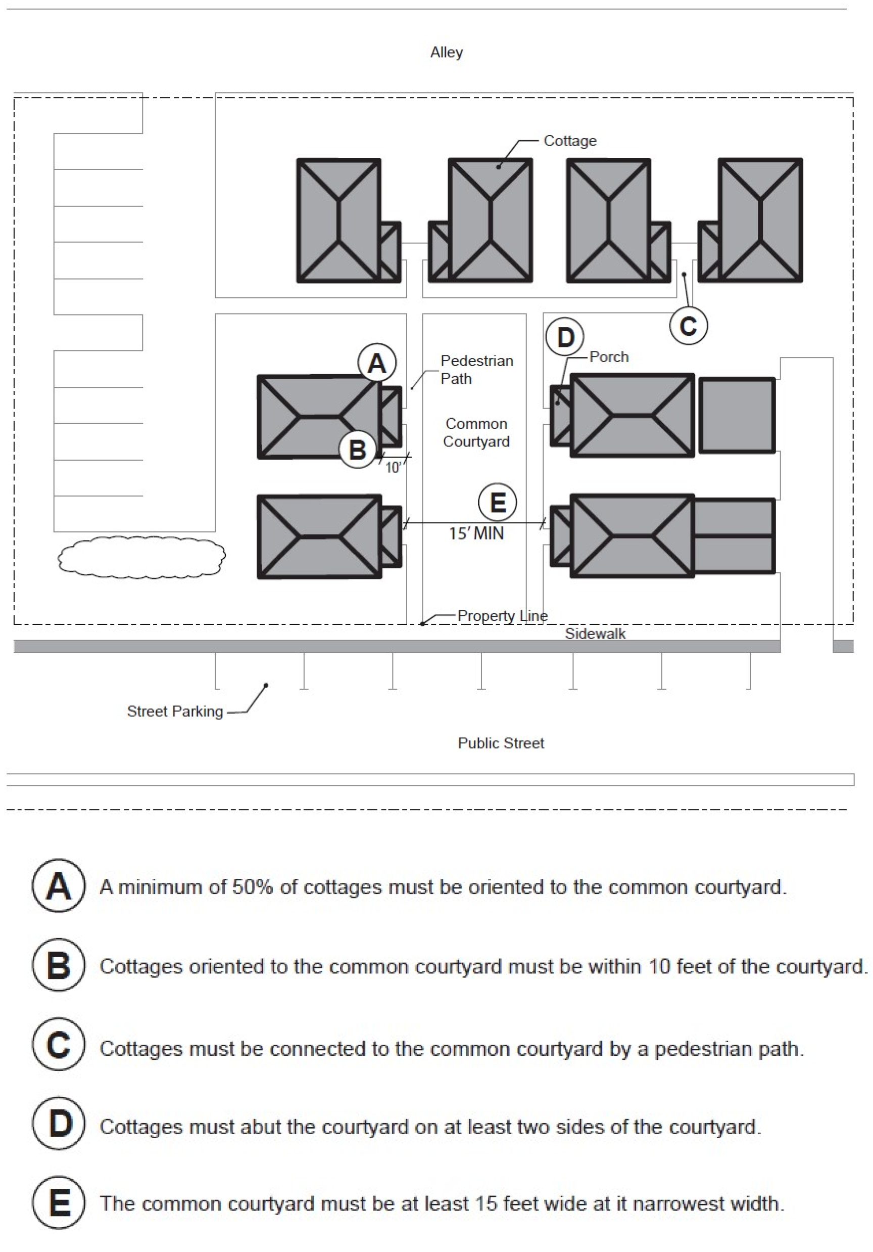
9.
Community Buildings. Cottage cluster projects may include community buildings for the shared use of residents that provide space for accessory uses such as community meeting rooms, guest housing, exercise rooms, day care, or community eating areas. Community buildings must meet the following standards:
a.
Each cottage cluster is permitted 1 community building.
b.
The community building shall have a maximum floor area of 1,400 sf. In addition, the community building shall count towards the maximum average floor area of the cottage cluster, pursuant to Subparagraph 12.50.715.E.6.c.
c.
Community buildings shall not be used for long-term residential occupancy. For the purposes of this standard, long-term residential occupancy shall mean the continued use by the same occupant for longer than 14 days in any 60-day timeframe or for more than 30 days in a calendar year.
10.
Pedestrian Access.
a.
An accessible pedestrian path must be provided that connects the main entrance of each cottage to the following:
i.
The common courtyard;
ii.
Shared parking areas;
iii.
Community buildings; and
iv.
Sidewalks in public rights-of-way abutting the site or rights-of-way if there are no sidewalks.
b.
The pedestrian path shall meet the standards in Subsection 12.50.420.D.5.
11.
Windows. All street-facing façades of cottages within 20 feet of a street property line must meet the window coverage standards of Subsection 12.50.710.C.2.
12.
Articulation and Detailed Design Elements. When a cottage cluster project exceeds the threshold in Subsection 12.50.710.B.2, the following standards apply:
a.
If any part of a cottage is within 20 feet of a street property line, its street-facing façade must include:
i.
Three of the articulation elements in Subsection 12.50.710.C.4; and
ii.
Five of the detailed design elements in Subsection 12.50.710.C.5.
b.
The façade of each cottage facing the common courtyard must include:
i.
Two of the articulation elements in Subsection 12.50.710.C.4; and
ii.
Three of the detailed design elements in Subsection 12.50.710.C.5.
13.
Parking Design. (Illustrated in Figure 12.50.715-H.)
a.
Clustered Parking. Off-street parking may be arranged in clusters, subject to the following standards:
i.
A parking cluster must not exceed 8 contiguous spaces.
ii.
Parking clusters must be separated from other spaces by at least 4 feet of landscaping.
iii.
Clustered parking areas may be covered.
iv.
Parking clusters must also meet the standards in Section 12.50.360, except where they conflict with these standards.
b.
Parking Location and Access.
i.
Off-street parking areas with 5 or more spaces shall not be located within 20 feet from any property line that abuts a street as defined in Section 12.01.500.
ii.
No off-street parking space or vehicle maneuvering area is permitted between a property line that abuts a street and the front façade of cottages located closest to that property line.
iii.
No off-street parking space is permitted within 10 feet of any other property line external to the cottage cluster, except property lines abutting an alley. Driveways and drive aisles are permitted within 10 feet of other external property lines.
c.
Screening. Landscaping, fencing, or walls at least 3 feet tall shall separate clustered parking areas and parking structures from common courtyards and public streets.
d.
Garages and Carports.
i.
Garages and carports (whether shared or individual) must not abut common courtyards.
ii.
Detached garages must not exceed 400 square feet in floor area.
iii.
Garage doors shall not exceed 20 feet in width.
14.
Accessory Buildings. Accessory buildings shall not exceed 400 square feet in floor area.
15.
Existing Structures. On a lot or parcel to be used for a cottage cluster project, an existing, single detached dwelling on the same lot at the time of proposed development of the cottage cluster may remain within the cottage cluster project area under the following conditions:
a.
The existing dwelling may be non-conforming with respect to the requirements of this Subsection 12.50.715.E.
b.
The existing dwelling may be expanded up to a maximum height of 25 feet or a maximum building footprint of 900 square feet; however, existing dwellings that exceed these maximum height and/or footprint standards may not be expanded.
c.
The floor area of the existing dwelling shall not count towards the maximum average floor area of a cottage cluster, per Subparagraph 12.50.715.E.6.c.
d.
The existing dwelling shall be excluded from the common courtyard orientation standards, per Subparagraph 12.50.715.E.7.b.
Figure 12.50.715-H:
Cottage Cluster Parking Design Standards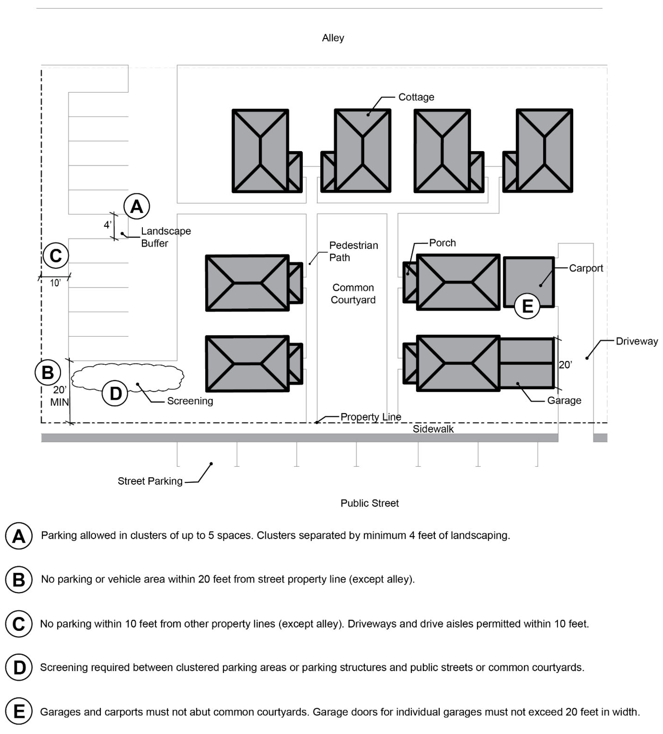
(Ord. 6451 § 1, 2023; Ord. 6401 § 1, 2022)
12.50.720 - Additional Design Standards for Multiple-Dwelling Residential.
A.
Purpose. These design standards are intended to generally assure that new multiple dwelling development will be compatible with the City's character, while allowing for some flexibility for new development. In addition, the regulations provide certainty to property owners, developers and neighbors regarding allowable design.
B.
Applicability.
1.
The standards of this section apply to all new multiple dwelling structures in all zones, unless alternative standards are approved through a discretionary process.
2.
The standards of this section do not apply to accessory structures, detached garages, or carports.
3.
For residential development in mixed-use zones, the standards of Section 12.50.830 shall supersede the standards pertaining to ground floor windows in paragraph C.2, below.
4.
For purposes of this section, the term "primary structure(s)" includes all structures containing dwelling units.
C.
Standards.
1.
Main Entries. In addition to the standards in Subsection 12.50.710.C.1, main entries for each primary multiple dwelling structure shall meet the following standards:
a.
In light rail or mixed-use zones, common main entries to multiple dwelling structures shall open directly to the building exterior at ground floor level. The main entry may be elevated above finished grade on a porch, stoop, portico, antechamber, wheelchair ramp or similar architectural feature.
b.
In light rail or mixed-use zones, ground floor and upper story residential units in a multiple dwelling structure fronting on a major pedestrian route may share 1 or more entries accessible directly to the route.
c.
In mixed-use zones, multiple dwelling structures shall have at least 1 main building entry for each 150 feet length of the front elevation.
d.
All main entries facing the street shall have a front porch, either roofed or recessed within the building plane, that is at least 9 feet wide and 7 feet deep.
2.
Roofs. Roofs on the primary structure(s) shall meet the following standards:
a.
Eaves. Roof eaves shall project from the building wall at least 12 inches on all elevations. Buildings with cornices meeting the standards of subparagraph c, below, are exempt from this standard.
b.
Pitch. Roof pitch on sloped roofs shall be no flatter than 4/12 and no steeper than 12/12 unless approved under subparagraph c or d, below.
c.
Reduced Pitch Permitted. Roofs with less than a 4/12 pitch shall be approved subject to either of the following standards:
i.
The roof top is usable as a deck or balcony accessible from an interior room, and has a maximum area of 150 square feet; or
ii.
The roof has a 2-part cornice, the upper portion of which projects at least 6 inches from the building face and at least 2 inches farther from the building face than the lower portion, and the overall height of which is based on the height of the building as shown in Table 12.50.720-1.
d.
Alternative Pitches Permitted. Alternative roof pitches shall be approved if the roof structure includes either:
i.
Extended eaves with a minimum projection of 2 feet on all elevations;
ii.
Hips; or
iii.
Clerestory windows on the front elevation.
e.
Roof-Mounted Equipment. All roof-mounted equipment, including heating, ventilation, air-conditioning, satellite dishes and other communication equipment, but excluding solar and wind energy systems, shall be placed behind parapets, architecturally compatible screens, roof-top landscaping, or other equivalent means as requested by the applicant and approved by the Review Authority.
3.
Exterior Finish Materials. The standards of this subsection shall be met on all building façades:
a.
Plain concrete block, plain concrete, corrugated metal, plywood and sheet pressboard are not allowed as exterior finish material, except as secondary finishes covering no more than 10% of the surface area of each façade;
b.
Composite boards manufactured from wood or other products, such as mineral-fiber cement siding, may be used when the board product is less than 6 inches wide; and
c.
Where wood products are used for siding, the siding shall be shingles or horizontal siding, not shakes.
(Ord. 6401 § 1, 2022; Ord. 6322 § 1, 2019; Ord. 6193 § 1, 2016; Ord. 6178 § 1, 2016)
12.50.800 - Design Standards for Non-Residential and Mixed-Use Development.
Design standards for non-residential and mixed-use development include the following sections:
12.50.810 Purpose and Applicability
12.50.820 Main Entries
12.50.830 Ground Floor Windows
12.50.840 Articulation and Detailed Design
12.50.845 Step-Back Requirements
12.50.850 Improvements and Activities between Streets and Buildings
12.50.870 Sidewalk Dining and Displays
12.50.875 Drive Through Facilities
12.50.880 Outdoor Storage
12.50.890 Utilitarian Functions
(Ord. 6401 § 1, 2022)
12.50.810 - Purpose and Applicability.
A.
Purpose. These standards are generally intended to work together with the standards in Sections 12.50.100 through 12.50.600 to create attractive commercial, industrial, institutional and mixed-use areas by promoting aesthetically pleasing environments, safety, privacy, energy conservation and recreational opportunities. The design standards generally assure that new development will be compatible with the City's character, while allowing for some flexibility for new development. In addition, the regulations provide certainty to property owners, developers and neighbors regarding allowable design and the differences between designs which are and are not permitted.
B.
Applicability. Except where noted in each subsection, the standards of this section apply to all non-residential and mixed-use development in light rail, urban center or mixed-use zones. In addition, some standards may apply in standard commercial or industrial zones.
(Ord. 6401 § 1, 2022; Ord. 6322 § 1, 2019; Ord. 6178 § 1, 2016)
12.50.820 - Main Entries.
A.
Applicability. The standards of this section apply:
1.
In all non-residential light rail zones;
2.
In all mixed-use zones; and
3.
In standard commercial or industrial zones.
B.
Entry Orientation. All ground-floor tenant spaces with at least 25 feet of frontage facing a public or private street shall have at least 1 building entry oriented to the street. This entry shall open directly to the building exterior, at the ground floor level, but may be elevated above finished grade if a stoop, porch, portico or similar architectural feature is included in the design.
C.
Entry Orientation on Corner Lots. On corner lots a main building entry may be oriented to either of the streets or to the corner where the 2 streets intersect.
D.
Multiple Entries Required on Longer Façades.
1.
In the MU-C zone, where a single tenant occupies 200 feet or more of a building façade, 1 additional entry shall be provided for each 200 feet of street façade.
2.
In light rail commercial zones, building façades over 300 feet in length shall provide at least 2 main building entries.
3.
In light rail industrial and institutional zones, building façades over 400 feet in length shall provide at least 2 main building entries.
E.
Sidewalk Connections to Entries. Unless exempt under subsection H below, a pedestrian sidewalk or pathway shall be provided directly to the building entrance from all street sidewalks.
F.
Standards for Main Building Entries.
1.
All main entries shall comply with applicable accessibility standards.
2.
Main entries shall be lighted to a minimum level of 32.5 lumens/square meter. Light sources shall be 3 to 12 feet above finished grade and equipped with cut-off fixtures to minimize glare.
3.
Main entries to non-residential buildings fronting on transit streets shall remain open during the business hours for the building.
4.
Entries to mixed-use buildings containing dwelling units shall be clearly marked with a physical feature incorporated into the building or an appropriately scaled element on the façade.
5.
Main entries shall be highlighted with at least 3 of the following architectural features: recessed doorway(s); overhangs or canopies; transom windows; at least 2 ornamental light fixtures flanking the entry; larger, transparent or more prominent doors; or pilasters or columns that frame the doorway.
G.
Additional Entries. Buildings may have more street-oriented main entries than required by this section, and may have secondary entrances oriented to off-street parking and loading areas.
H.
Exceptions.
1.
Freestanding banking institutions and restaurants in the MU-C zone may locate the main entry on any façade of the building.
2.
Direct sidewalk connections required under subsection E above may be constructed in alternate locations if the following site conditions are present:
a.
The grade slope between the building and the street is greater than 1:12 for more than 20 feet and a more accessible pedestrian route to the building is available on a different side; or
b.
Natural resources or mature, healthy trees larger than 8-inch caliper are located between the building and the street, which would be unavoidably and irreparably degraded by constructing a reasonably direct pedestrian connection, and an alternative route without such impacts is available.
(Ord. 6401 § 1, 2022; Ord. 6322 § 1, 2019; Ord. 6178 § 1, 2016)
12.50.830 - Ground Floor Windows.
A.
Purpose. Long blank façades facing streets or public areas create unattractive streetscapes and reduce pedestrians' perception of safety. The standards of this subsection are intended to create attractive street environments and to enhance street safety by providing surveillance opportunities where buildings face streets and public areas. The standards also improve commercial exposure by encouraging window displays, which also increases street activity and pedestrian security.
B.
Applicability.
1.
The standards of this section apply to:
a.
All non-residential and mixed-use development in light rail, mixed-use and urban center zones; and
b.
Residential development in mixed-use zones, except for middle housing development in MU-N, MU-VTC, or SCR-V.
2.
In applicable development projects and zones identified in paragraph 1 above, the standards of this section apply to any façade visible from and facing any:
a.
Street;
b.
Major pedestrian route;
c.
Direct pedestrian way leading from a light rail station site;
d.
Park;
e.
Plaza; or
f.
Other public outdoor space.
C.
Exceptions.
1.
In the SCC-MM and SCFI zones these standards apply only on public street frontages and pedestrian ways leading from the street or transit station site to the building(s).
2.
In the MU-C zone, these standards do not apply to buildings larger than 10,000 square feet with on-site service docks and loading areas and leased to 2 individual tenants.
3.
In the SCBP and SCI zones, these standards do not apply.
4.
Except as provided in subsection D, below, standards for residential development are provided in Section 12.50.700.
D.
Standards for Residential Development in a Mixed-Use Zone.
1.
Multi-dwelling residential structures shall have windows or doorways on any exterior walls facing a public street, public open space, pedestrian walkway and/or transit station. The combined area of the windows, and doorways shall be at least 50% of the length and 50% of the area of the ground level wall (defined as the area up to the finished ceiling height of the fronting space or 15 feet above finished grade, whichever is less).
2.
Townhouse structures shall have windows or doorways on any exterior walls facing a public street, public open space, pedestrian walkway and/or transit station. The combined area of the windows and doorways shall be at least 20% of the ground level wall area (defined as the area up to the finished ceiling height of the fronting space or 15 feet above finished grade, whichever is less).
3.
In implementing this standard, the area of ground level wall shall exclude the area of any garage door facing the public street, public open space, pedestrian walkway and/or transit station.
E.
Standards for Non-Residential Development.
1.
All buildings shall have ground floor display windows or windows with views into the building interior. Such windows shall occupy the percentages of the ground level exterior wall area as shown on Table 12.50.830-1. Windows in entry doors also meet this standard. For purposes of this section, "ground level wall area" is defined as the area up to the finished ceiling height of the first floor or 15 feet above exterior grade, whichever is less.
2.
Lower sills on required windows shall be 3 feet or less above exterior grade. If interior floor levels prohibit this sill height, the sill may be at least 2 feet above the finished first floor level, but not more than 5 feet above exterior grade.
3.
Required windows shall not be darkly tinted or mirrored unless the wall is at least 50 feet from the sidewalk.
(Ord. 6401 § 1, 2022; Ord. 6322 § 1, 2019; Ord. 6294 § 1, 2019)
12.50.840 - Articulation and Detailed Design.
A.
Applicability.
1.
The standards of this section apply to:
a.
All non-residential and mixed-use development in light rail, mixed-use and urban center zones;
b.
Commercial or institutional development in standard commercial or industrial zones.
2.
In applicable development projects identified in paragraph 1, above, these standards apply to any portion of a façade meeting 1 or more of the following thresholds:
a.
Facing, adjacent to, and visible from a street, major pedestrian route, or direct pedestrian way leading from a light rail station site;
b.
Visible from and facing onto a park, plaza, or other public outdoor space.
B.
Architectural Features. Front building elevations shall avoid a flat appearance by including architectural features to provide variation and articulation. Architectural features meeting this standard include, but are not limited to, the features listed below or similar features. Window or entry cutouts on an otherwise flat façade do not meet this standard.
1.
Cornices;
2.
Bases;
3.
Pilasters;
4.
Belt courses;
5.
Ornamental masonry;
6.
Bays;
7.
Recesses;
8.
Arcades;
9.
Display windows;
10.
Recessed or detailed entries;
11.
Fenestration; and/or
12.
Similar architectural features requested by the applicant if approved by the Review Authority.
(Ord. 6401 § 1, 2022; Ord. 6322 § 1, 2019; Ord. 6294 § 1, 2019; Ord. 6178 § 1, 2016)
12.50.845 - Step-Back Requirements.
A.
Purpose. Step-back standards promote a more comfortable pedestrian environment by reducing visual impacts of taller building masses and providing light and air at the street level.
B.
Applicability. The standards of this section apply:
1.
In light rail commercial zones; and
2.
In mixed-use zones.
C.
Standards.
1.
Step-back requirements shall be achieved, at the option of the applicant, by 1 of 2 methods:
a.
Floors above the third floor shall be stepped back at least 10 feet but not more than 20 feet, with additional step-backs on higher floors provided at the option of the applicant; or
b.
Floors above the third floor shall be stepped-back to maintain a maximum angle of 60 degrees between the top of the street-side façade and the back of the sidewalk on the opposite side of the street.
2.
If requested by the applicant, the Review Authority may waive this standard upon finding that:
a.
Ground floor window treatments, entry placement, façade relief and other architectural treatments of the building provide visual interest, pedestrian-sensitive design, and human scale at street level;
b.
The architectural features described in subparagraph a, above, are extended to upper floors through variations in design, detail, and proportion, avoiding a monolithic façade; and
c.
Building massing would not obstruct sunlight reaching the back of the sidewalk on the opposite side of the street for more than 4 daylight hours between March 21 and September 21.
(Ord. 6401 § 1, 2022; Ord. 6322 § 1, 2019)
12.50.850 - Improvements and Activities between Streets and Buildings.
A.
Purpose. Where buildings are not constructed immediately adjacent to the public street, attractive improvement of front yard setbacks promotes and enhances pedestrian scale and orientation and encourages pedestrian use of the area.
B.
Applicability. The standards of this section apply:
1.
In all standard commercial and industrial zones;
2.
In light rail zones; and
3.
In mixed-use zones.
C.
Standards.
1.
The front yard between the public sidewalk or right-of-way and any adjacent building shall be improved with irrigated landscaping or hardscaping. Where provided, landscaping shall comply with the applicable requirements of Section 12.50.220.
2.
Where hardscaping is used in lieu of landscaping in front yards, the hardscaped areas shall contain at least 2 pedestrian-friendly amenities integrated into the overall site design. Examples of such amenities include but are not limited to the following:
a.
Weather canopies or sunshades;
b.
Benches or low walls with seating areas;
c.
Drinking fountains and/or water features;
d.
Free-standing planters and/or raised planting beds;
e.
Street furniture;
f.
Public art or sculpture; or
g.
Other design features requested by the applicant if approved by the Review Authority.
3.
Paragraph 2 above does not apply to paved pedestrian connections between the sidewalk and building entrances.
(Ord. 6401 § 1, 2022; Ord. 6322 § 1, 2019; Ord. 6178 § 1, 2016)
12.50.870 - Sidewalk Dining and Displays.
A.
Purpose. These standards are intended to assure sidewalk dining and pedestrian-oriented commercial displays and sales are consistent with the purposes of the underlying zones, will not detract from streetscape appearance, and will not adversely impact adjacent properties.
B.
Applicability. The standards of this section apply:
1.
To commercial development in all light rail zones;
2.
To commercial development in the MU-VTC zone; and
3.
On arterial street frontages in the SCC-MM zone.
C.
Standards.
1.
Sidewalk seating for restaurants and display stands for pedestrian-oriented sales are permitted between the curb and the back of the sidewalk in the MU-VTC zone, the SCR-V zone and in all SC commercial zones. Such activities shall comply with the following standards:
a.
The activity has received a Street Vendors License under Municipal Code Chapter 5.36;
b.
The activity occurs only when the related business is open for business (unless otherwise permitted by the Street Vendor License); and
c.
The activity maintains at least 5 feet unimpeded sidewalk clearance for pedestrian movement.
2.
Except as specified in paragraph 1 above, permanent outdoor displays by commercial uses is not permitted.
(Ord. 6401 § 1, 2022; Ord. 6322 § 1, 2019; Ord. 6110 § 7, 2015)
12.50.875 - Drive-Through Facilities.
A.
Purpose. Drive-through facilities provide convenience for customers in automobiles, but may impede traffic flow and conflict with pedestrian and bicycle safety. The standards in this section are intended to allow drive-through facilities in appropriate locations with additional design considerations to mitigate these negative impacts.
B.
Applicability. The standards of this section apply:
1.
In all light rail or mixed-use zones in which drive-through facilities uses are allowed; and
2.
On arterial street frontages in the SCC-MM zone.
C.
Standards in Light Rail Zones.
1.
Drive-through facilities are not permitted within 400 feet of an LRT station site; and permitted farther than 400 feet from an LRT station site if the drive-through facility is not the primary method of sale or service.
2.
Access to a drive-through facility shall be limited to 1 driveway crossing unless the Review Authority finds that the following standards are met:
a.
Construction of a single 2-way driveway access single joint use driveway is not practicable due to site size, topography or other constraints; or
b.
The single driveway would necessitate construction of a return drive lane parallel to and within 15 feet of a major pedestrian route.
3.
The number of service windows, bays or lanes in a drive-through facility is not limited if the development meets the minimum floor area ratio of the zone.
4.
The drive-through service window, bay or lane and all queuing lanes shall be located as far as practicable from any transit street, major pedestrian route, or LRT station site.
5.
Drive-through facilities within 50 feet of a major pedestrian route shall have landscaping installed to screen the service windows, bays or lanes from view to the maximum extent practicable.
6.
Pedestrian circulation within any site with drive-through facilities shall be clearly marked for both automobile and pedestrian traffic.
D.
Standards in Mixed-Use Zones.
1.
A maximum of 2 drive-through service lanes shall be permitted between a building façade and a public street right-of-way.
2.
Drive-through lanes located between a building façade and a public right-of-way shall be buffered by evergreen shrubs. The shrubs shall be not less than 2 feet higher than finished grade at the time of planting. Evergreen shrubs shall be of the types that grow to be at least 36 inches higher than finished grade.
(Ord. 6401 § 1, 2022; Ord. 6322 § 1, 2019)
12.50.880 - Outdoor Storage.
A.
Purpose. These standards are intended to assure outdoor storage areas in non-residential zones are consistent with the purposes of the underlying zones, will not detract from streetscape appearance, and will not adversely impact adjacent properties.
B.
Applicability. These standards apply to all standard industrial zones, and to commercial, industrial and institutional development in all light rail zones. In the SCC-MM zone these standards apply only on arterial street frontages.
C.
Standards.
1.
In standard industrial zones, outdoor storage is permitted only behind an opaque fence at least 6 feet in height.
2.
Except as otherwise specified in Section 12.50.870, commercial uses in light rail zones shall not have permanent outdoor displays or storage of materials or equipment. The term "equipment" as used in this subsection does not apply to motor vehicles licensed for street use and regularly used in the conduct of business.
3.
Within the light rail industrial zones, outdoor storage of inventory or equipment may be permitted adjacent to a transit street, major pedestrian route, or light rail station site if the following standards are met:
a.
The Planning Director finds that there is no other practicable location for the storage on site;
b.
The storage area is surrounded by dense screening material or landscaping, compliant with subparagraph c below, which completely obscures visibility from the public right-of-way; and
c.
Any screening material is constructed of decorative or architectural materials consistent with the materials in the primary structure. Chain link fences, plain concrete walls or wooden fences are not considered to meet this standard.
(Ord. 6401 § 1, 2022; Ord. 6322 § 1, 2019)
12.50.890 - Utilitarian Functions.
A.
Purpose. The standards of this section are intended to create more attractive streetscapes by reducing utilitarian features adjacent to the street. Except where the word "shall" is used, the standards are not to be construed as mandatory approval standards.
B.
Applicability.
1.
The standards of this section apply to all non-residential development and the non-residential components of mixed-use development in:
a.
Standard commercial and industrial zones; and
b.
Light rail, mixed-use, and urban center zones.
2.
In applicable development projects identified in paragraph 1, above, these standards apply to any façade meeting 1 or more of the following thresholds:
a.
Facing, adjacent to, and visible from a street, major pedestrian route, or direct pedestrian way leading from a light rail station site; or
b.
Visible from and facing onto a park, plaza, or other public outdoor space.
C.
Standards.
1.
To reduce their visual and audible impacts, roof-mounted equipment, vent and chimneys shall be placed behind parapets, architecturally compatible screens, roof-top landscaping or other equivalent measures requested by the applicant if approved by the Review Authority.
2.
Loading docks, HVAC equipment, trash compaction and collection, and other utility and service functions shall be located either within, beside or behind the building rather than on the street-side façade.
3.
Wall- or ground-mounted mechanical, electrical and communications equipment shall be screened from streets and adjacent properties. Such screens shall be architecturally compatible with the building and landscaping.
(Ord. 6401 § 1, 2022; Ord. 6322 § 1, 2019; Ord. 6294 § 1, 2019; Ord. 6178 § 1, 2016)
12.50.900 - Public Benefit Standards.
Public benefit standards include the following sections:
12.50.910 Purpose and Applicability.
12.50.920 Enhanced Building and Site Design Elements
12.50.930 Sustainable Development Practices
12.50.940 Crime Prevention through Environmental Design
(Ord. No. 6493, §§ 1, 2(Exh. A), 1-7-2025; Ord. 6401 § 1, 2022)
12.50.910 - Purpose and Applicability.
A.
Purpose. In some cases, proposed development may not be able to achieve the standards or requirements of this Code, due to the nature of the proposed use, site constraints, or other concerns. To offset or mitigate requested adjustments from the standards, applicants shall include development amenities that provide benefit within or beyond the boundaries of the development site. This section is intended to provide measurable standards for such public benefits, which are consistent with the goals and policies of the Comprehensive Plan. However, a Public Benefit does not have to directly relate to the standard being adjusted.
B.
Applicability. These standards may be applied by the Review Authority in any discretionary land use application process in which an applicant has requested an adjustment or variance from the standards of this Code, unless such standard specifically allows an adjustment without discretionary review.
C.
Exceptions. The following shall not be considered a public benefit:
1.
Meeting base code standards.
2.
Providing a use that is permitted, permitted with limitations or conditionally permitted in the zone.
3.
Complying with requirements from other agencies or entities that have jurisdictional authority.
(Ord. No. 6493, §§ 1, 2(Exh. A), 1-7-2025; Ord. 6401 § 1, 2022)
12.50.920 - Enhanced Building and Site Design Elements.
These elements can be considered Public Benefits if they exceed base requirements for building and site design. These elements must be verifiable on a site plan and/or through the use of drawings, specifications, and other materials.
A.
Assembly and civic buildings such as theaters, hotels, cultural centers, schools, places of assembly, and government buildings should include appropriately-scaled landmark features, such as towers, cupolas or pediments.
B.
Projects with edges adjacent to transit streets and major pedestrian routes should include street furniture such as seating, shelters, ornamental pedestrian scale lighting and an inside row of canopy trees to complement those in the curbside landscape strip.
C.
Projects containing residential uses should include a range of housing types and styles to suit a variety of lifestyles and incomes, both on an ownership and rental basis, such as ADUs, primary bedrooms and full bathrooms on main floors, and live-work units.
D.
Projects at intersections should incorporate special corner architectural features such as clock towers or cupolas or publicly accessible plazas.
E.
Where masonry is used for exterior finish, decorative patterns should be employed. These decorative patterns may include multi-colored masonry units, such as brick, tile, stone or cast stone, in a layered or geometric pattern, or multi-colored ceramic tile used in conjunction with materials such as concrete or stucco.
F.
Ornamental features such as molding, entablatures, pediments and friezes are encouraged at the roofline. Linear features such as molding should be at least 8 inches wide.
G.
Multi-dwelling, mixed-use, and non-residential buildings less than 3 feet from any parallel sidewalk or pedestrian accessway should install weather protection features over the sidewalk or pedestrian way.
H.
Traditional storefront elements are encouraged on any commercial building elevation facing a major pedestrian route. These elements include:
1.
Front building walls placed within 10 feet of abutting street right-of-way boundaries in zones where there is no maximum setback.
2.
Large display windows in the lower façade.
3.
In zones where there is no window requirement on upper stories, regularly spaced windows are provided in upper stories.
4.
Decorative trim such as window hoods around upper floor windows.
5.
Decorative cornices near the top of the façade.
6.
Piers or pilasters, typically masonry.
I.
Upper stories should be articulated with features such as bays and balconies.
J.
Windows allowing views into interior activity areas or displays at the pedestrian level in non-residential buildings are encouraged. These windows shall not include glass curtain walls, reflective glass or painted or darkly tinted glass, smooth faced concrete block, concrete panels, steel panels, and non-durable materials are discouraged unless privacy issues are involved.
K.
Building entrances should include clearly recognizable features such as: canopies, porticoes, recessions, projections, arcades, and raised cornice parapets. Pedestrian spaces at entrances incorporating landscaping and eating amenities are encouraged.
L.
Artwork approved through the Public Art Program shall be incorporated into the development site with necessary easements, on public property, or through payment of an in-lieu option.
M.
Design solutions that compensate for the requested adjustment are encouraged. Examples of design solutions for common adjustments include, but are not limited to, the following:
1.
Front Setback Reduction.
a.
Limit fencing to placement 10 feet behind the plane of the encroaching façade in order to visually provide an open yard.
b.
Place any utility cabinet underground in order to visually provide an open yard.
c.
Provide consolidated driveways in order to increase the size of the available yard area(s).
2.
Design Element Reduction (does not include glazing).
a.
Provide non-fabric rain protection at least 4 feet in depth along 50% of the same façade.
b.
Provide a 10% increase in glazing above the base requirement on the same façade (i.e., if the base requirement is 10% of façade area, the design solution would require 20% of the façade area devoted to glazing).
(Ord. No. 6493, §§ 1, 2(Exh. A), 1-7-2025; Ord. 6401 § 1, 2022; Ord. 6322 § 1, 2019)
12.50.930 - Sustainable Development Practices.
A.
Habitat Friendly Development Practices. Use of habitat friendly development practices, including Low Impact-Development Approach (LIDA) techniques are a key element of the adopted Tualatin Basin Fish & Wildlife Habitat Program. LID techniques are encouraged to reduce the environmental impacts of new development, and to provide flexibility to encourage the protection of qualified Habitat Benefit Areas. The following recommended habitat-friendly development practices should be considered where technically feasible and appropriate and are considered public benefits if they are in addition to base requirements for stormwater, wildlife protection, and natural resource protection. These practices must be verifiable on a site plan or through the use of cut sheets and material details.
1.
Design and Construction Practices to Reduce Hydrologic Impacts.
a.
Using pervious paving materials for residential driveways.
b.
Incorporating stormwater management in street rights-of-way, subject to the approval of the City Engineer.
c.
Landscaping with rain gardens to provide on-lot detention and filtering and groundwater recharge.
d.
Using green roofs to reduce runoff and energy costs, improve air quality, and enhance aesthetics.
e.
Integrating stormwater treatment into usable open space
f.
Retaining rooftop runoff in rain barrels for future on-site irrigation.
g.
Using multi-functional open drainage systems in lieu of conventional curb-and-gutter systems.
h.
Using bioretention cells in parking lot islands to reduce runoff volume and filter pollutants.
i.
Applying a site-specific combination of storm water systems (a "treatment train") to provide multiple opportunities for treatment and to reduce the possibility of system failure.
j.
Reducing impervious surface areas of residential driveways by narrowing widths or using shared driveways.
k.
Allowing narrower street rights-of-way through stream corridors whenever possible to reduce adverse impacts of transportation corridors.
2.
Design and Construction Practices to Minimize Impacts on Wildlife Corridors and Fish Passage.
a.
Integrating fencing into site vegetation to guide animals toward crossings under, over, or around streets and roads.
b.
Using bridge crossings rather than culverts wherever possible.
c.
If culverts are utilized, installing slab, arch or box culverts, preferably using bottomless designs that more closely mimic stream bottom habitat.
d.
Designing stream crossings for fish passage and other design features to facilitate terrestrial wildlife passage, as illustrated in Figure 12.50.930-A.
| Figure 12.50.930-A: Examples of Stream Crossings with Fish and Terrestrial Wildlife Passage Provided | |
|---|---|
 |  |
e.
Extending vegetative cover through the wildlife crossing in the migratory route, along with sheltering areas.
3.
Miscellaneous other Habitat-Friendly Design and Construction Practices.
a.
Using native plants throughout the development, not only in areas with Significant Natural Resource Area Overlay.
b.
Locating required landscaping adjacent to Habitat Benefit Areas.
c.
Reducing light-spill off into Habitat Benefit Areas from development.
d.
Preserving and maintaining existing trees and tree canopy coverage, and plant trees where appropriate to increase future tree canopy coverage.
B.
Green Buildings and Sites. Providing a green building certification by a third party, including LEED Gold, Green Globes Emerald, Living Building Challenge, National Green Building Standard, WELL Building Standard, Energy Trust of Oregon's Energy Performance Score, or other certification programs as approved by the Planning Director.
1.
Water Usage Efficiency and Reduction in Green Developments. Where installed, above-ground cisterns for rainwater or graywater collection must meet the following standards:
a.
Individual cisterns or racks of cisterns larger than 80 gallon capacity may not be attached to the front façade of the primary structure; and
b.
Cisterns must either be painted to match the color of the adjacent building wall, the trim, or the rain gutter; or be screened from the street by structures, plantings, or fences.
2.
Energy Usage Efficiency and Reduction in Green Developments.
a.
Where installed, solar electric systems must meet the following standards:
i.
On a flat roof, the panels must be mounted flush or on racks. Panels or racks cannot extend more than 5 feet above the top of the highest point of the roof, not including the parapet wall, and must be set back at least 5 feet from the edge of the roof.
ii.
On a pitched roof, the plane of the panels must be set back at least 3 feet from both the eave and the ridgeline.
iii.
Photovoltaic roofing shingles or tiles may be directly applied to the roof surface.
iv.
Photovoltaic glazing may be integrated into windows or skylights.
b.
Where installed, roof-mounted wind turbine systems must meet the following standards:
i.
Wind turbines may be proposed only on buildings meeting the minimum setbacks of the applicable zone.
ii.
The height of a roof-mounted wind turbine may exceed the base zone height by up to 50%, or 25 feet above the height of the building on which it is mounted, whichever is less.
iii.
Turbines must have an AWEA-rated sound level of 45 dBA or less. The noise standards of the Hillsboro Municipal Code also apply to wind turbine operation.
C.
Storm Water Management. The following methods should be used to reduce contaminants from hard surfaces, improve infiltration improvement, and reduce or eliminate water quality treatment or detention facilities.
1.
Using eco roofs and roof gardens wherever practicable.
2.
Using pervious paving for parking areas and walkways.
3.
Using infiltration or flow-through planters, bio-retention cells, and/or rain gardens.
D.
Noise and Privacy. The following methods should be used to reduce external and internal noise and enhance privacy.
1.
Using enhanced landscaping or water features to buffer or mask sound.
2.
Providing internal streets and sidewalks to buffer activity and noise.
3.
Locating bedrooms and quiet rooms away from noise sources.
4.
Insulating activity rooms.
5.
Providing sound-rated walls, floors and sound-absorbing materials on the building exterior.
6.
Locating shared community and/or commercial spaces on the first floor.
E.
Accessibility and Visitability.
1.
Providing "zero-rise" residential entries without steps or thresholds.
2.
Providing paths of travel from the street, sidewalk or driveway which have no steps, are at least 36 inches wide and are no steeper than 1:20 (5% grade) for walkways or 1:12 for ramps.
3.
Providing ground floor residential entries with 32-inch clear opening doorways and 36-inch clear width hallways.
4.
In dwellings, providing a full bath on the ground floor, with adequate dimensions to allow a person in a wheelchair to enter and close the door.
F.
Third Places.
1.
Designing residential developments to include multi-purpose indoor or outdoor spaces. Interior multi-purpose rooms should accommodate both passive and active assembly Uses (such as community meetings and exercise classes). Outdoor multi-purpose spaces should accommodate both passive Uses (such as wetland viewing areas) and active Uses (such as sport courts or community gardens).
2.
Designing Mixed-Use and non-residential developments to include outdoor hardscaped plazas or courtyards which could accommodate both private Uses (such as outdoor seating for restaurants) and public Uses (such as farmers markets and street vendors).
(Ord. No. 6493, §§ 1, 2(Exh. A), 1-7-2025; Ord. No. 6488, § 2(Exh. A), 12-3-2024; Ord. 6401 § 1, 2022)
12.50.940 - Crime Prevention through Environmental Design.
A.
Providing an assessment from a CPTED certified professional that describes the site and building design elements that address crime prevention using the CPTED principles of territoriality, natural surveillance, access management, and maintenance.
(Ord. No. 6493, §§ 1, 2(Exh. A), 1-7-2025; Ord. 6401 § 1, 2022)