
Hyde Park City Zoning Code
12.230 Airport
Overlay
12.230.010 Purpose
The Airport Limitation Overlay Zones are intended to establish standards assuring the long range, safe and beneficial use of the Logan-Cache County Airport as it relates to the Hyde Park City Zoning Ordinances.
HISTORY
Adopted by Ord. 2015-03 on 5/13/2015
12.230.020 General Provisions
- These regulations reinforce specific provisions in the Logan-Cache Airport Master Plan (August 11, 1992) and Cache Countywide Comprehensive Plan (January 27, 1998), and the Hyde Park City General Plan, each plan as amended.
- The boundary of any officially recognized Airport Limitation Overlay Zone shall be as it appears on a map and/or other documents approved by the Hyde Park City council.
HISTORY
Adopted by Ord. 2015-03 on 5/13/2015
12.230.030 Reserved
12.230.040 Airport Zoning Commission
- Commission Established: The Planning Commission is designated as the "Hyde Park Airport Zoning Commission" as prescribed in Utah Code Annotated section 72-10-405. In this Chapter and State Law, any references to the “Airport Zoning Commission” shall also mean the Planning Commission. If the Planning Commission is empowered in the Hyde Park Zoning Ordinance to take actions that are duties of the Airport Zoning Commission as prescribed by Utah Law, the Planning Commission shall be presumed to be functioning as the Airport Zoning Commission.
- Duties: The airport zoning commission shall recommend boundaries of the various zones to be established and the regulations to be adopted pertaining to any airport hazard area and to perform such other duties as may be assigned to it by Hyde Park City Council or Utah law.
HISTORY
Adopted by Ord. 2015-03 on 5/13/2015
Amended by Ord. 2019-05 on 4/24/2019
12.230.050 Airport Board Of Adjustment
The Hyde Park Appeal Authority is designated as the "airport board of adjustment" as prescribed in Utah Code Annotated section 72-10-408. In this Chapter and state law, any references to the "airport board of adjustment" shall mean the Hyde Park Appeal Authority.
If the Hyde Park Appeal Authority is empowered in the Hyde Park Zoning Ordinance to take actions that are duties of the airport board of adjustment as prescribed in Utah law, the Hyde Park Appeal Authority shall be presumed to be functioning as the airport board of adjustment.
HISTORY
Adopted by Ord. 2015-03 on 5/13/2015
12.230.060 Schedule Of Uses
The following table indicates the uses and conditions required of those uses within the five (5) designated zones for the airport:
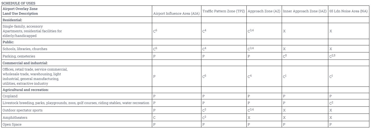
Notes:
- If allowed, aviation easement and disclosure must be required as a condition of development.
- Any structure associated with uses allowed in the 65 Ldn noise contour must be located outside the 65 Ldn noise contour.
- If no reasonable alternative exists, use should be located as far from extended centerline as possible.
- If allowed, disclosure of airport proximity must be required as a condition of development. An aviation easement should be considered based on proximity to runway centerline.
- Transportation facilities in the 65 Ldn noise contour (i.e., roads, railroads, waterways) must comply with part 77 requirements.
- Disclosure of airport proximity should be required as a condition of development.
HISTORY
Adopted by Ord. 2015-03 on 5/13/2015
12.230.070 Airport Master Plan
All uses and regulations pertaining to the airport limitation overlay zone shall be in compliance with and subject to the provisions of the airport master plan, airport layout plan and noise contour map as adopted by the Logan-Cache Airport Authority Board or as amended and is incorporated into this chapter by reference as it pertains to airport land uses.
HISTORY
Adopted by Ord. 2015-03 on 5/13/2015
12.230.080 Airport Zones
In order to carry out the provisions of this Chapter, there are hereby created and established certain zones which include all of the land lying beneath the Approach Surfaces, Transitional Surfaces, Horizontal Surfaces and Conical Surfaces as they apply to the Logan-Cache Airport. Such zones are shown on the Logan-Cache Airport "part 77" airspace drawing consisting of two (2) sheets, prepared by Armstrong Consultants, and dated March, 1997, which are attached to the ordinance codified in this Chapter, and made a part hereof. An area located in more than one (1) of the following zones is considered to be only in the zone with the more restrictive height limitation. The various zones are hereby established and defined as follows:
- Airport Influence Area (AIA): An area within the incorporated portions of Hyde Park City, proximate to an airport, which is recognized by the Hyde Park City Council as containing lands which might be affected by noise and/or safety hazards associated with aircraft operations associated with Logan-Cache airport. The AIA extends from the airport to the outer edge of the conical surface.
- Traffic Pattern Zone (TPZ): This zone extends from the airport to the outer edge of the horizontal surface.
- 65 Ldn Noise Area (NA): The area within the sixty-five (65) decibel yearly day-night average sound level.
- Inner Approach Zone (IAZ): The inner edge of this zone coincides with the width of the primary surface of runway 17/35 and is one thousand feet (1,000') wide. It extends at a uniform width of one thousand feet (1,000') to a horizontal distance of five thousand feet (5,000') from the primary surface. The centerline of the inner approach zone is a continuation of the centerline of runway 17/35.
- Approach Zone (AZ): The area within the FAR "part 77" approach surface for each runway.
- Runway Precision Instrument Approach Zone: The inner edge of this approach zone coincides with the width of the primary surface and is one thousand feet (1,000') wide. The approach surface expands outward uniformly to a width of sixteen thousand feet (16,000') at horizontal distance of fifty thousand feet (50,000') from the primary surface. The centerline of the approach zone is the continuation of the centerline of the runway. This is the planned condition at the approach end to runway 17.
- Runway Non-precision Instrument Approach Zone (Larger Than Utility Aircraft): The inner edge of this approach zone coincides with the width of the primary surface and is one thousand feet (1,000') wide. The approach zone expands outward uniformly to a width of three thousand five hundred feet (3,500') at a horizontal distance ten thousand feet (10,000') from the primary surface. Its centerline is the continuation of the centerline of the runway. This is the condition at the approach end to runway 35.
- Visual Runway Approach Zone (Larger Than Utility Aircraft): The inner edge of this approach zone coincides with the width of the primary surface and is five hundred feet (500') wide. The approach surface expands uniformly to a width of one thousand five hundred feet (1,500') at horizontal distance of five thousand feet (5,000') from the primary surface. The centerline of the approach zone is a continuation of the centerline of the runway. This is the condition at the approach end to runway 10 and 28.
- Transitional Zones: The transitional zones are the areas beneath the transitional surfaces.
- Horizontal Zones: The horizontal zone is established by swinging arcs of ten thousand feet (10,000') radii from the center of each end of the primary surface of runway 17/35 and connecting the adjacent arcs by drawing lines tangent to those arcs. The horizontal zone does not include the approach and transitional zones.
- Conical Zone: The conical zone is established as the area that commences at the periphery of the horizontal zone and extends outward therefrom a horizontal distance of four thousand feet (4,000').
HISTORY
Adopted by Ord. 2015-03 on 5/13/2015
12.230.090 Airport Regulations
- Conforming Uses Only: All uses in the airport limitation overlay zones shall be subject to the regulations of this chapter and prescribed development standards within the Airport Master Plan as amended.
- Creation Of Airport Hazards Prohibited: No variance, permit or use shall be allowed in the airport hazard area that would create or enhance an airport hazard.
- Use And Operational Limitations Within Airport Limitation Overlay Zones: No use shall be permitted which:
- Creates or tends to create electrical interference to navigational devices and communication between aircraft and airports.
- Creates or tends to create gas, smoke, dust, glare or other visual hazards in the atmosphere around airports or in the airport hazard area.
- Creates or tends to create structures that interfere with aircraft safety.
- Creates or tends to create any type of hazard for the airport that would inhibit or constrain safe and acceptable airport operations including uses that:
- Create electrical interference with radio communication between the airport and aircraft.
- Make it difficult for pilots to distinguish between airport lights and other lights.
- Result in glare in the eyes of pilots using the airport.
- Impair visibility in the vicinity of the airport; or
- Otherwise endanger the landing, taking off, or maneuvering of aircraft.
- Height Limitation: Except as exempted in subsection E of this section or otherwise provided in this title, no structure shall be erected, altered or maintained, and no tree shall be allowed to grow, in any zone created by this title to a height in excess of the applicable height limit herein established for such zone. Such applicable height limitations are hereby established for each of the zones in question as follows:
- Runway precision instrument approach zone: Slopes fifty feet (50') outward for each foot upward beginning at the end of and at the same elevation as the primary surface and extending to a horizontal distance of ten thousand feet (10,000') and continues on for a distance of forty thousand feet (40,000') at a slope of forty feet (40') outward for each foot upward along the extended runway centerline. (Approach to runway 17.)
- Runway non-precision instrument approach zone (larger than utility aircraft): Slopes thirty four feet (34') outward for each foot upward beginning at the end of and at the same elevation as the primary surface and extending to a horizontal distance of ten thousand feet (10,000') along the extended runway centerline. (Approach to runway 35.)
- Visual runway approach zone: Slopes twenty feet (20') outward for each foot upward beginning at the end of and at the same elevation as the primary surface and extending to a horizontal distance of five thousand feet (5,000') along the extended runway centerline. (Approach to runways 10 and 28.)
- Transitional zones: Slope seven feet (7') outward for each foot upward beginning at the sides of and at the same elevation as the primary surface and the approach surface, and extending to a height of one hundred fifty feet (150') above the airport elevation. In addition to the foregoing, there are established height limits sloping seven feet (7') outward for each foot upward beginning at the sides of and at the same elevation as the approach surface, and extending to where they intersect the conical surface. Where the precision instrument runway approach zone projects beyond the conical zone, there are established height limits sloping seven feet (7') outward for each foot upward beginning at the sides of and at the same elevation as the approach surface, and extending a horizontal distance of five thousand feet (5,000') measured at ninety degree (90°) angles to the extended runway centerline.
- Horizontal zone: Established at one hundred fifty feet (150') above the airport elevation or at a height of four thousand six hundred seven feet (4,607') above mean sea level (MSL).
- Conical zone: Slopes twenty feet (20') outward for each foot upward beginning at the periphery of the horizontal zone and at one hundred fifty feet (150') above the airport elevation (4,607 feet MSL) and extending to a height of three hundred fifty feet (350') (4,807 feet MSL) above the airport elevation.
- Within ten thousand feet (10,000') of the centerline of runway 17/35 the following height limitation shall apply:
- From five thousand feet (5,000') of centerline of runway, the height of all structures, uses and trees shall not exceed fifty feet (50') above the contour of the land on which it is proposed to be located.
- From five thousand feet (5,000') to ten thousand feet (10,000') of centerline of runway, the height of all structures, uses and trees shall not exceed seventy five feet (75') above the contour of the land on which it is proposed to be located.
- For structures or use from five thousand feet (5,000') to ten thousand (10,000) of centerline of runway, may apply to the City planning commission to exceed the seventy five feet (75') height limitation if the structure or use does not pose a threat based on the conditions outlined in subsection C of this section.
- Exemptions To Height Limitation:
- Any object that would be shielded by existing structures of a permanent and substantial character or by natural terrain or topographic features of equal or greater height, and would be located in the congested area of a city, town or settlement where it is beyond all reasonable doubt that the structure so shielded will not adversely affect safety in air navigation.
- Structures up to and including thirty five feet (35') in height above the ground level at its site where the ground elevation at its site is less than or equal to thirty five feet (35') below the height limitations defined in subsection D of this section, and is beyond all reasonable doubt that the structure will not adversely affect safety in air navigation. If in doubt, submission of FAA Form 7460-1, Notice Of Proposed Construction (as described in HPMC 12.230.100) shall be used to determine its effect on safety in air navigation.
- Proposed development within an airport influence area shall conform with 14 C.F.R. Part 77 as amended.
- As a condition to granting a building permit, subdivision plat, or a requested zoning change within the airport influence area, the Applicant may be required by the City to grant or sell to the airport owner, at appraised fair market value, an avigation easement if:
- It is desired to remove, lower, or otherwise terminate a nonconforming structure or use;
- The approach protection necessary cannot, because of constitutional limitations, be provided by airport land use regulations under this Chapter; or
- It appears advisable that the necessary approach protection be provided by the acquisition of property rights rather than by airport zoning regulations.
HISTORY
Adopted by Ord. 2015-03 on 5/13/2015
Amended by Ord. 2024-04 on 2/14/2024
12.230.100 Notification
- Required: Except as provided in subsection B of this section, and in addition to all other local notification and permitting requirements, each person who proposes any of the following construction or alteration shall complete and submit an FAA form 7460-1, notice of proposed construction, to the local jurisdiction and to the federal aviation administration in accordance federal aviation regulation part 77, Object Affecting Navigable Airspace:
- Any construction or alteration of more than two hundred feet (200') in height above the ground level at its site.
- Any construction or alteration of greater height than an imaginary surface extending outward and upward at a slope of one hundred to one (100:1) for a horizontal distance of twenty thousand feet (20,000') from the nearest point of the nearest runway at the Logan-Cache Airport.
- Exemptions From Notification:
- Any object that would be shielded by existing structures of a permanent and substantial character or by natural terrain or topographic features of equal or greater height, and would be located in the congested area of a city, town or settlement where it is beyond all reasonable doubt that the structure so shielded will not adversely affect safety in air navigation.
- Any antenna structure of twenty feet (20') or less in height, except one that would increase the height of any antenna structure.
- Time Of Notice: The notice required under subsection A of this section must be submitted at least thirty (30) days before the earlier of the following dates:
- The date the proposed construction or alteration is to begin.
- The date an application for a construction permit is to be filed.
HISTORY
Adopted by Ord. 2015-03 on 5/13/2015
12.230.110 Airport Development Standards
The Hyde Park City Council recognizes that the Cache County Council may adopt by resolution or enact by ordinance uniform development standards and procedures for facilities within the airport property itself, because the airport is not located within Hyde Park City boundaries. If amendments are made to boundary lines and any airport property is then within the corporate limits of Hyde Park City, the Hyde Park City Council shall adopt appropriate ordinances for construction in that area.
HISTORY
Adopted by Ord. 2015-03 on 5/13/2015

