
Jamestown City Zoning Code
ARTICLE 3
DEFINITIONS
Sec. 3.1.- Definitions.
The following terms shall have the meaning ascribed to them below:
Abandoned. Not occupied or in use for 60 or more consecutive days.
Accessory building. A detached subordinate building, the use of which is incidental to that of the principal building and located on the same lot.
Accessory dwelling unit. A dwelling that exists either as part of a principal dwelling or as an accessory building that is secondary and incidental to the use of the property as single-family residential.
Accessory use. A use incidental to and customarily associated with a specific principal use, located on the same lot or parcel.
Active recreational elements. Parks, playgrounds, athletic fields, basketball or tennis courts, swimming pools, clubhouses, covered decks or pavilions, constructed picnic facilities.
Adaptive reuse. The conversion of an existing building built for one use to another use, typically to address some aspect of physical or functional obsolescence.
Addition (to an existing building). An extension or increase in the floor area or height of a building or structure.
Adult establishment. The definition of "adult establishment" for purposes of this ordinance shall be consistent with G.S. ch. 14, art. 26A, as currently written or hereafter amended. Adult establishments include adult bookstores, adult motion picture and mini motion picture theaters, adult video sales and rentals, adult live entertainment business and massage businesses as those terms are defined by G.S. § 14.202.10, and adult motels and adult cabarets.
Adult motel is defined as a hotel, motel or similar commercial establishment that: (a) offers accommodations to the public for any form of consideration; provides patrons with closed circuit television transmissions, films, motion pictures, video cassettes, slides or other photographic reproductions that depict or describe "specified sexual activities," or "specified anatomical areas" as one of its principal business purposes; or (b) offers a sleeping room for rent for a period of time that is less than ten hours; or (c) allows a tenant or occupant of a sleeping room to subagent the room for a period of time that is less than ten hours.
Adult cabaret is defined as a nightclub, bar, restaurant or other commercial establishment that regularly features, exhibits or displays as one of its principal business purposes: (a) persons who appear nude or semi-nude, or (b) live performances which are characterized by the exposure of "specified anatomical areas" or by "specified sexual activities," or (c) films, motion pictures, video cassettes, slides or other photographic reproductions which depict or describe "specified anatomical areas."
Agricultural use. The use of land for agricultural purposes, including farming, dairying, stock watering, pasturage agriculture, horticulture, floriculture, viticulture, and animal and poultry husbandry, and the necessary accessory uses for storing the products. The term shall include incidental retail sales by the producer of products raised on the farm. Agriculture does include forest management and timber harvesting activities, provided a management plan for that activity has been prepared by a professional forester registered in the State of North Carolina. See definition of forest land.
Alley. A roadway which affords only a secondary means of access to abutting property.
Along drainage. The area parallel to and within 50 feet of the drainage channel.
Alteration. Any change, addition, relocation, replacement, or other physical modification to a sign or sign structure other than routine maintenance or change of copy not requiring the replacement of any part of the sign face.
Animal unit. A unit of measurement developed by the U.S. Environmental Protection Agency that is used to compare different types of animal operations.
Appeal, floodplain. A request for a review of the floodplain administrator's interpretation of any provision of this ordinance. (This definition applies to flood hazard regulations.)
Appeal, zoning. A request for a review of the planning director's interpretation of any provision of this land development ordinance.
Appraised value. The value assigned to a structure by the Guilford County Tax Assessor or by an MAI-certified real estate appraiser.
Area of shallow flooding. A designated Zone AO on a community's Flood Insurance Rate Map (FIRM) with base flood depths determined to be from one to three feet. These areas are located where a clearly defined channel does not exist, where the path of flooding is unpredictable and indeterminate, and where velocity flow may be evident. "Area of special flood hazard" see "special flood hazard area (SFHA)." (This definition applies to flood hazard regulations.)
Assembly. A joining together of completely fabricated parts to create a finished product.
Athletic field. Outdoor sites, often requiring equipment, designed for formal athletic competition in field sports (e.g., softball, soccer, football).
Auto wrecking. An activity that provides open storage, disassembling, or salvaging for more than two junked motor vehicles.
Automobile repair services, major. An establishment primarily engaged in one or more of the following activities: 1) general repair or service, 2) engine repair, 3) installation or repair of transmissions, 4) installation or repair of automotive glass, 5) installation or repair or exhaust systems, 6) repair of tops, bodies and interiors, and 7) automotive painting and refinishing.
Automotive repair services, minor. An establishment primarily engaged in one or more of the following activities: 1) diagnostic service and tune-ups, 2) installation or repair of air conditioners, brakes, carburetors, electrical systems, fuel systems, generators and starters, and radiators, 3) lubricating service, and 4) front end and wheel alignment.
Awning. A cloth, plastic, or other nonstructural covering permanently attached to a building that may be raised or retracted to a position against the building when not in use.
Balloon, accent. A small balloon (or group of small balloons) displayed at heights of less than eight feet.
Balloon, tethered. A large balloon (or group of balloons of any size) intended for commercial promotion and tethered at a business location.
Banquet facility (or special events facility). A facility rented by individuals or groups for private functions such as a ceremony, celebration, reception or similar activity.
Bar. An establishment primarily engaged in the retail sale of beer or wine for consumption on the premises. Such establishment must obtain an ABC license for on-premise beer or wine consumption only. The establishment may also be engaged in the retail sale of prepared food for on premise consumption.
Basement. Any area of the building having its floor subgrade (below ground level) on all sides. (This definition applies only with respect to flood hazard regulations.)
Base flood elevation. The elevation to which structures and uses regulated by this ordinance are required to be elevated or flood proofed. The determination of the water surface elevations of the base flood is published in the Flood Insurance Study. When the BFE has not been provided in a "special flood hazard area," it may be obtained from engineering studies available from a federal, state, or other source using FEMA approved engineering methodologies. This elevation, when combined with the "freeboard," establishes the "regulatory flood protection elevation."
Base flood. The flood having a one percent chance of being equaled or exceeded in any given year (100-year flood).
Bed-and-breakfast inn. A private residence that offers sleeping accommodations to lodgers in eight or fewer rooms for rent, is the innkeeper's (owner or operator) principal residence while renting rooms to lodgers, and serves breakfasts at no extra cost to its lodgers. For the purpose of this definition, a lodger means a person who rents a room in a bed-and-breakfast inn for fewer than seven consecutive days.
Bedroom. Shall have the same meaning as that assigned to it in the North Carolina State Building Code Council.
Berm, erosion control. A mound of material and/or ditch the purpose of which is to divert the flow of run-off water.
Best management practices. Conservation practices or systems of practices and management measures that: (a) control soil loss and reduce water quality degradation caused by nutrients, animal waste, toxins, and sediment; (b) minimize adverse impacts to surface water and groundwater flow, circulation patterns, and to the chemical, physical, and biological characteristics of surface water bodies and wetlands; and (c) properly manage use and storage of fertilizers/pesticides. May use a structural or nonstructural management-based practice used singularly or in combination to reduce nonpoint source inputs to receiving waters in order to achieve water quality protection goals. (Also known as an SCM "stormwater control measure.")
Block. The land lying within an area bounded on all sides by streets.
Blockface. That portion of a block or tract of land facing the same side of a single street and lying between the closest intersecting streets.
Board of adjustment. A quasi-judicial body, appointed by the town council, which is given certain powers under this ordinance. For the purposes of this ordinance, any reference to the board of adjustment shall be considered synonymous with the planning board, as the planning board shall serve as the board of adjustment when required.
Boarding house. A dwelling or part thereof, in which lodging is provided by the owner or operator to more than three boarders.
Bookstore, adult. A bookstore: 1) which receives a majority of its gross income during any calendar year from the sale of publications (including books, magazines and other periodicals) which are distinguished or characterized by their emphasis on matter depicting, describing or relating to sexual activities or anatomical area, or 2) having a preponderance of its publications, books, magazines and other periodicals which are distinguished or characterized by their emphasis on matter depicting or relating to sexual activities or anatomical areas.
Borrow. Fill material which is required for on-site construction and is obtained from other locations.
Breakaway wall. A wall that is not part of the structural support of the building and is intended through its design and construction to collapse under specific lateral loading forces without causing damage to the elevated portion of the building or the supporting foundation system.
Brewpub. A restaurant that prepares handcrafted natural beer as an accessory use intended for consumption on the premises.
Buffer. An area of land planted or constructed to separate uses. Also, an area of natural or planted vegetation through which stormwater runoff flows in a diffuse manner so that the runoff does not become channelized and which provides for infiltration of the runoff and filtering of pollutants. The buffer is measured from the normal pool elevation of impounded structures and from the top of bank of each side of streams or river.
Buffer easement. An easement intended to permanently maintain an area of land, including landscaping, berms, walls, fences, and building setbacks, that is located between land uses of different character and is intended to mitigate negative impacts of the more intense use on a residential or vacant parcel.
Buffer zone. The strip of land adjacent to a lake or natural watercourse, the width of which is measured from the edge of the water to the nearest edge of the disturbed area, with the 25 percent of the strip nearer the land-disturbing activity containing natural or artificial means of confining visible siltation.
Buildable or zoning lot. One or more lots of record in one undivided ownership with sufficient total area, sufficient area exclusive of easement, flood hazards, well and septic tank fields, total dimensions, and street access to permit construction thereon of a principal building together with its required parking and planting yards.
Building. Any structure used or intended for supporting or sheltering any use or occupancy. See also structure.
Building line. A line perpendicular to the lot depth which establishes the horizontal distance between the structure and the front property line excluding the outermost steps, uncovered porches, gutters, and similar fixtures.
Building separation. The minimum required horizontal distance between buildings.
Build-to line. An alignment establishing a specific distance from the curb line to where the principal structure shall be built.
Built-upon area. That portion of a development project that is covered by impervious or partially impervious cover to the extent that the partially impervious surface does not allow water to infiltrate through the surface and into the subsoil including buildings, pavement, recreation facilities (e.g., tennis courts), etc. (Note: Slatted decks and the water area of a swimming pool are not considered built-upon area.)
Caliper inches. Quantity in inches of the diameter of trees measured at the height of six inches above the ground for trees four inches in trunk diameter and 12 inches above the ground for trees over four inches in trunk diameter.
Canopy. A permanent, unattached roofed structure that shelters a use or activity from the weather.
Certificate of compliance/occupancy. A statement, signed by the enforcement officer, setting forth either that a building or structure complies with the provisions of this ordinance, or that building, structure, or parcel of land may lawfully be employed for specified uses, or both.
Channel lettering. A sign design technique involving the installation of three-dimensional lettering against a background, typically a sign face or building façade.

Example of Channel Lettering
Channelization. Any improvements or other construction activity which occurs within or in the vicinity of an existing natural drainage way or perennial stream which directs or relocates said waterway along some desired course, by increasing its depth or by the use of piping or any other manmade storm drainage structures.
Chemical storage facility. A building, portion of a building, or exterior area adjacent to a building used for the storage of any chemical or chemically reactive products.
Chicane. An artificial feature creating extra turns in a roadway, used on town streets to slow the speed of traffic, by creating a horizontal deflection causing vehicles to slow as they would for a curve.
Cigar bar. As defined in G.S. § 130A-492, an establishment with a permit to sell alcoholic beverages that satisfies all of the following:
a.
Generates 60 percent or more of its quarterly gross revenue from the sale of alcoholic beverages and 24 percent or more of its quarterly gross revenue from sale of cigars;
b.
Has a humidor on the premises; and
c.
Does not allow individuals under the age of 21 to enter the premises. Revenue generated from other tobacco sales, including cigarette vending machines, shall not be used to determine whether an establishment satisfies the definition of cigar bar.
Cluster development. A development design technique that concentrates buildings on a portion of the site to allow the remaining land to be used for recreation, open space, or preservation of environmentally-sensitive land areas. Buildings are grouped together in order to conserve land resources and provide for innovation in the design of the project. This term includes non-residential development as well as single-family subdivisions and multi-family developments that may or may not involve the subdivision of land.
Collector street plan. A plan, adopted by the local governing body, for streets not shown on the thoroughfare plan and showing collector and, if appropriate, lower classification streets in the planning area.
Common area(s). All areas, including private streets, conveyed to an owners' association within a development or owned on a proportional undivided basis in a condominium development.
Common open space. Open space that is (1) owned in common and maintained by the owners of lots in a subdivision (i.e., a homeowners' association), or (2) owned by a private individual or entity but managed and maintained for common use by residents, occupants or customers of the development. Common open space shall be preserved by either a conservation easement or deed of restriction.
Completed. Work has progressed to the point that, in the opinion of the planning director, it is sufficiently completed in accordance with the approved plans and specifications that the work can be utilized for its intended purposes. For permanent runoff control structures this generally means that the following have been accomplished:
a.
The dam has been constructed to the approved lines and grades; (2) all slopes have been fine graded, seeded, mulched, fertilized, and tacked to establish permanent ground cover; (3) principal and emergency spillways have been installed at the approved elevations and dimensions; and (4) permanent velocity controls on the inlet and outlet pipes and channels have been installed.
Composting facility. A facility in which only stumps, limbs, leaves, grass and untreated wood collected from land clearing or landscaping operations are deposited.
Condominium. Real estate that is developed pursuant to the North Carolina Condominium Act, G.S. ch. 47C.
Congregate care facility. A facility providing shelter and services for ambulatory individuals at least 55 years of age who by reason of their age, functional impairment, or infirmity may require meals housekeeping and personal care assistance. Congregate care facilities do not include nursing homes or similar institutions devoted primarily to the care of the chronically ill or the incurable.
Conservation easement. A non-possessory interest of a holder in real property imposing limitations or affirmative obligations, the purposes of which include retaining or protecting natural, scenic, or open space values of real property, assuring its availability for agricultural, recreational, or open space use, protecting natural resources, maintaining or enhancing air or water quality, or preserving historical, architectural, archaeological, or cultural aspects of real property.
Conservation subdivision. A subdivision in which the lot sizes are reduced below those normally required in the zoning district in which the development is located, in return for the provision of permanent open space.
Cottage development. A cluster of small detached single-family residences constructed to specific design standards and arranged around common open space, generally at higher density than the underlying zoning would allow for traditional detached single-family residential development.
Cottage home. A small detached single-family residence constructed to specific design standards and arranged around common open space as part of a cottage development.
County. Refers to Guilford County, North Carolina.
Critical area. The area adjacent to a water supply intake or reservoir where risk associated with pollution is greater than from the remaining portions of the watershed. The critical area is defined as extending either one-half mile from the normal pool elevation of the reservoir in which the intake is located or to the ridgeline of the watershed (whichever comes first); or one-half mile upstream from the intake located directly in the stream or river (run-of-the-river), or the ridgeline of the watershed (whichever comes first). Since WS-I watersheds are essentially undeveloped, establishment of a critical area in not required. Local governments may extend the critical area as needed. Major landmarks such as highways or property lines may be used to delineate the outer boundary of the critical area if these landmarks are immediately adjacent to the appropriate outer boundary of one-half mile.
Critical root zone. The rooting area of a tree established to limit root disturbance, generally defined as a circle with a radius extending from a tree's trunk to the furthest point of the crown dripline.
Cul-de-sac. A short local street having one end open to traffic and the other end permanently terminated by a vehicular turnaround.
Curb bulb. An extension of the curb into the street, beyond the standard edge of the curb, which narrows the width of the roadway and is used to slow the speed of traffic on town streets. The curb bulb may be used for landscaping, pedestrian crosswalk, or for a combination of uses. Sometimes referred to as a "bulb out."
Day care center. A facility licensed by the State of North Carolina for the care of children or adults for periods of less than 24 hours per day.
Density. The amount of development per acre permitted on a parcel under the applicable zoning, commonly measured as dwelling units per acre (du/ac). Density shall be expressed as the number of units per gross acre. See also "development, density of."
Density credit. An increase in the density allowed under a zoning district. The rules governing the issuance of density bonuses vary by zoning district.
Density, high. A density option for development where the density exceeds the applicable limit for development under the low-density option.
Density, low. A density option for new development wherein the density, measured in dwelling units per acre for single-family detached residential development and in percentage of the land surface covered by built-upon area for all other residential and nonresidential development, does not exceed the applicable limit in Table 19.20-5 or Table 19.20-9.
Detention pond. A wet or dry stormwater holding area, either natural or manmade, which filters and releases stormwater to nearby or adjoining water bodies in a gradual fashion. Also see definition of best management practices.
Developer. A person, including a governmental agency or redevelopment authority, who undertakes any development and who is the landowner of the property to be developed or who has been authorized by the landowner to undertake development on that property.
Development. For the general purposes of this ordinance, with the exception of the definition related to watershed regulation in Article 19, the term "development" shall mean any of the following:
a.
The construction, erection, alteration, enlargement, renovation, substantial repair, the movement to another site, or demolition of any structure.
b.
The excavation, grading, filling, clearing, or alteration of land.
c.
The subdivision of land as defined in G.S. § 160D-802.
d.
The initiation or substantial change in the use of land or the intensity of use of land.
Development (related to watershed regulations). Any land-disturbing activity which adds to or changes the amount of impervious or partially impervious cover on a land area or which otherwise decreases the infiltration of precipitation into the soil. (This definition applies to the watershed standards in Article 19.)
Development agreement. An agreement between the Town of Jamestown and a developer pursuant to G.S. § 160D-1001 for a large-scale development with a lengthy build-out period and having a public-private partnership component involving mutual financial interests.
Development, density of. The density of development shall be determined using a gross acreage system. The total area of the tract, including areas to be used for new streets, rights-of-way, drives, parking, structures, recreation areas, dedicated areas, and required setbacks shall be used for density calculations.
Discharging landfill. A facility with liners, monitoring equipment and other measures to detect and/or prevent leachate from entering the environment and in which the leachate is treated on site and discharged to a receiving stream.
Disposal. As defined in G.S. § 130A-290(a)(6), the discharge, deposit, injection, dumping, spilling, leaking, or placing of any solid waste into or on any land or water so that the solid waste or any constituent part of the solid waste may enter the environment or be emitted into the air or discharged into any waters, including groundwaters.
Disposal (of hazardous or toxic substance(s)). The destruction, discharge, deposit, injection, dumping, spilling, leaking, or placing of any hazardous waste or toxic substance into or on any air, land, or water.
Disposal facility. A facility or part of a facility at which hazardous waste or toxic substance is intentionally placed into or on any land or water, and at which hazardous waste or toxic substance will remain after closure.
Diverter. A constructed feature designed to prevent left turns or through movements into a residential area, used as method to calm traffic on town streets.
Domestic wastewater discharge. The discharge of sewage, nonprocess industrial wastewater, other domestic wastewater, or any combination of these items. It includes liquid waste generated by domestic water-using fixtures and appliances from any residence, place of business, or place of public assembly even if it contains no sewage. Examples of domestic wastewater include once-through noncontact cooling water, seafood packing facility discharges, and wastewater from restaurants.
Drainage, dispersed. Drainage spread out, as opposed to collected in channels, so as to effect increased sheet flow and overland flow.
Drainage, enhanced. Drainage carried by existing natural drainage ways which have been enhanced to resist soil erosion and stream bank degradation. An enhanced natural drainageway is achieved with the installation of an engineered measure (i.e., netting, riprap) which will resist soil erosion and allow infiltration within the natural drainageway.
Drainageway. Any natural or manmade channel that carries surface runoff from precipitation.
Drainageway and open space area, dedicated. The area designated for floodplain and open space purposes on a recorded subdivision plat and thereby dedicated to the public for such purposes and, where approved by the Town, for utilities.
Drainageway, improved. Drainage channeled by impervious surfaces such as curb and gutter or concrete channels.
Drainageway, protected. Drainage channeled by pervious devices such as sod waterways, berms, channels, or swales which have been stabilized with vegetation, rip-rap, or a combination of these, to resist soil erosion.
Dripline. A vertical line extending from the outermost portion of a tree's canopy to the ground.
Dry detention pond. A pond which collects stormwater runoff, holds the water, and releases it slowly over a period of hours or days. It does not have a permanent pool and is sometimes referred to as a dry pond or wet weather pond.
Dwelling. A building that contains one or two dwelling units used, intended or designed to be used, rented, leased, let or hired out to be occupied for living purposes.
Dwelling unit. A single unit providing complete, independent living facilities for one or more persons, including permanent provisions for living, sleeping, eating, cooking and sanitation.
Easement. A grant of one or more of the property rights, such as right of access, by the property owner to, or for use by the public, a corporation, or other entity. Storage of debris including, but not limited to, yard waste on public easements shall be unlawful and shall be handled in the same manner as nuisance violations.
Electronic gaming operation. Any business enterprise, whether as a principal or accessory use, where persons utilize electronic machines, including, but not limited to computers and gaming terminals to conduct games including but not limited to sweepstakes, lotteries, games, and/or games of chance, and where cash or merchandise, or other items of value are redeemed or otherwise distributed, whether or not the value of such distribution is determined by electronic games played or by predetermined odds, which have a finite pool of winners. The term includes, but is not limited to internet sweepstakes, video sweepstakes, or cybercafés. This definition does not include any lottery endorsed, approved, or sponsored by the State of North Carolina, or arcade games of skill.
Elevated building. A non-basement building which had its lowest elevated floor raised above ground level by foundation walls, shear walls, posts, piers, pilings, or columns.
Encroachment. The advance or infringement of uses, fills, excavation, buildings, permanent structures, or development into a floodplain, which may impede or alter the flow capacity of a floodplain. (This definition applies only with respect to flood hazard regulations.)
Enforcement, complaint, based. Enforcement action initiated on the basis of information provided by a third-party complainant.
Enforcement officer. The town manager or his/her designee.
Enforcement, proactive. Enforcement action initiated at the discretion of the planning director independent of any third-party complaint.
Equestrian use. Paddocks, fields, stables, barns, riding rings, and other facilities provided for use by or for horses.
Erosion. The wearing away of land surface by the action of wind, water, gravity or any combination thereof.
Erosion, accelerated. Any increase over the rate of natural (i.e., undisturbed by human intervention) erosion as a result of land-disturbing activities.
Existing development. Those projects that are built or those projects that at a minimum have established a vested right under North Carolina zoning based on at least one of the following criteria:
a.
Substantial expenditure of resources (time, labor, money) based on a good faith reliance upon having received valid local government approval to proceed with the project; or
b.
Having a valid outstanding building permit; or
c.
Having an approved site-specific or phased development plan in compliance with G.S. § 160D-108. (This definition applies only with respect to watershed protection regulations.)
Existing lot (lot of record). A lot which is part of a subdivision, a plat of which has been recorded in the office of the register of deeds prior to the adoption of this ordinance, (if located in the Randleman Lake Watershed) or a lot described by metes and bounds, the description of which has been so recorded prior to October 1, 1993.
Existing manufactured home park or manufactured home subdivision. A manufactured home park or subdivision for which the construction of facilities for servicing the lots on which the manufactured homes are to be affixed (including, at a minimum, the installation of utilities, the construction of streets, and either final site grading or the pouring of concrete pads) was completed before the original effective date of this ordinance.
Family. One or more persons occupying a dwelling unit and living as a single household.
Family care home. A home meeting the North Carolina Residential Building Code with support and supervisory personnel that provides room and board, personal care and habilitation services in a family environment for six or fewer resident handicapped persons, pursuant to G.S. § 168-21.
Federal law reference. National pollutant discharge elimination system permits (applies to watershed standards only).
Fence. A physical barrier or enclosure consisting of wood, stone, brick, block, wire, metal, or similar material used as a boundary or means of protection or confinement, but not including a hedge or other vegetation.
Fixture, full cutoff. An outdoor light fixture shielded in such a manner that all light emitted by the fixture, either directly from the lamp or indirectly from the fixture, is projected below the horizontal plane as determined by photometric test or certified by the manufacturer.
Fixture, partial cutoff. An outdoor light fixture shielded in such a manner that more than zero, but less than ten, percent of the light emitted directly from the lamp or indirectly from the fixture is projected at angles above the horizontal plane, as determined by photometric test or certified by the manufacturer.
Flood and flooding. A general and temporary condition of partial or complete inundation of normally dry land areas from the overflow of inland waters or the unusual and rapid accumulation of runoff of surface waters from any source.
Flood insurance. The insurance coverage provided under the National Flood Insurance Program.
Floodplain administrator. The individual appointed to administer and enforce the floodplain management regulations.
Floodplain development permit. Any type of permit that is required in conformance with the provisions of this ordinance, prior to the commencement of any development activity.
Floodplain management. The operation of an overall program of corrective and preventive measures for reducing flood damage and preserving and enhancing, where possible, natural resources in the floodplain, including, but not limited to, emergency preparedness plans, flood control works, floodplain management regulations, and open space plans.
Floodplain management regulations. This ordinance and other zoning ordinances, subdivision regulations, building codes, health regulations, special purposed ordinances, and other application of police power which control development in flood-prone areas. This term describes federal, state, or local regulations, in any combination thereof, which provide standards for preventing and reducing flood loss and damage.
Flood insurance rate map (FIRM). An official map of the Town of Jamestown and its ETJ, on which the Federal Emergency Management Agency has delineated both the areas of special flood hazard and the risk premium zones applicable to the Town of Jamestown and its ETJ.
Flood insurance study. The official report provided by the Federal Emergency Management Agency (FEMA). The report contains flood profiles, as well as the flood boundary/floodway map and the water surface elevation of the base flood.
Flood plain. The relatively flat area or low land adjacent to the channel of a river, stream, or watercourse, lake, or other body of standing water, which has been or may be covered by floodwater and which is susceptible to being inundated by water from any source.
Flood prone area. See "floodplain."
Floodproofing. Any combination of structural and nonstructural additions, changes, or adjustments to structures that reduce or eliminate flood damage to real estate or improved real property, water and sanitation facilities, structures, and their contents.
Flood zone. A geographical area shown on a flood hazard boundary map or flood insurance rate map that reflects the severity or type of flooding in the area.
Floodway. The channel of a river or other watercourse and the adjacent land areas that must be reserved in order to discharge the base flood without cumulatively increasing the water surface elevation more than one foot.
Floodway fringe. The land area located between the floodway and maximum elevation subject to inundation by the base flood as defined in these definitions.
Floor. The top surface of an enclosed area in a building (including basement), i.e., top of slab in concrete slab construction or top of wood flooring in wood frame construction. The term does not include the floor of a garage used solely for parking vehicles.
Floor area, gross. The sum of the gross horizontal areas of the several floors of a building measured from the exterior face of exterior walls, or from the centerline of a wall separating two buildings, but not including interior parking spaces, loading space for motor vehicles or any space where the floor-to-ceiling height is less than six feet. Additionally, gross floor area includes areas covered by canopies and like structures under which an active use is occurring such as drive-through service, gasoline pumping, loading and/or storage of materials, and similar activities.
Forest land. Land that is a part of a forest unit that is actively engaged in the commercial growing of trees under a sound management program. Forestland includes wasteland that is a part of the forest unit, but the wasteland included in the unit must be appraised under the use-value schedules as wasteland. A forest unit may consist of more than one tract of forestland, but at least one of the tracts must meet the requirements in G.S. § 105-277.3(a)(3), and each tract must be under a sound management program.
Freeboard. The height added to the base flood elevation (BFE) to account for the many unknown factors that could contribute to flood heights greater than the height calculated for a selected size flood and floodway conditions, such as wave action, bridge openings, and the hydrological effect of urbanization on the watershed. The base flood elevation plus the freeboard establishes the regulatory flood protection elevation.
Fully shielded lighting fixture. A light fixture that is shielded in such a manner that light rays emitted by the fixture, either directly from the lamp or indirectly from the fixture, are projected below a horizontal plane running through the lowest point on the fixture where light is emitted.
Functionally dependent facility. A facility that cannot be used for its intended purpose unless it is located in close proximity to water, limited to a docking or port facility necessary for the loading and unloading of cargo or passengers, shipbuilding, or ship repair. The term does not include long-term storage, manufacture, sales, or service facilities. This definition applies only to the flood damage prevention standards.
Gated community. A subdivision, neighborhood, or residential development to which entry is restricted to residents and their guests. Often includes barriers such as gates, security personnel, fences and/or walls.
Gift shop. A retail space in which miscellaneous articles that are appropriate as gifts are sold.
Grade. A reference plane representing the average of finished ground level adjacent to any structure.
Grading. Any operation or occurrence by which the existing site elevations are changed, or where any ground cover, natural or man-made, is removed, or any buildings or other structures are removed, or any water course or body of water, either natural or man-made, is relocated on any site, thereby creating an unprotected area. The term "grading" is interchangeable with "land-disturbing activity."
Grading plan. The graphic plan, including narrative where appropriate, required by this ordinance as a prerequisite for a grading permit, the purpose of which is to explain existing conditions and proposed grading of land including any development and to describe the activities and measures to be undertaken to control accelerated soil erosion and sedimentation.
Grand opening. A promotional activity not exceeding 30 calendar days used by newly established businesses, within 60 calendar days after initial occupancy, to inform the public of their location and services available to the community.
Grandfathered. Not affected by a change in this ordinance absent physical modification or abandonment. Buildings, land uses, and lots or parcels of property that do not meet the standards of this ordinance but existed prior to the effective date of this ordinance, and complied with prior ordinances, regulations, and or standards, shall not be affected by this ordinance absent physical modification or abandonment.
Gravel. A clean or washed, loose, uniformly graded aggregate of stones from a lower limit of 0.08 inches to an upper limit of three inches in size.
Greenway. A linear open space along either a natural corridor such as a riverfront, stream valley, or ridgeline, or along a railroad right-of-way converted to recreational use, a canal, scenic road, or other route managed for public use that has been designated on an officially adopted greenway plan. Greenways typically link parks, nature preserves, cultural features, or historic sites with each other and/or with neighborhoods, schools, and commercial districts.
Group care facility. A facility licensed by the State of North Carolina, (by whatever name it is called, other than "family care home" as defined by this ordinance), with support and supervisory personnel that provides room and board, personal care, or habilitation services in a family environment for not more than 30 people.
Hazardous material. Any material listed as such in: Superfund Amendments and Reauthorization Act (SARA) section 302 Extremely Hazardous Substances (42 USC 1100 et seq.); Comprehensive Environmental Response, Compensation and Liability Act (CERCLA) Hazardous Substances (42 USC 9601 et seq.); or section 311 of the Clean Water Act, as amended (CWA) (33 USC 1251 et seq.; oil and hazardous substances) hereby incorporated by reference including any subsequent amendments and editions.
Hazardous or toxic substance. Any solid waste as defined in G.S. § 130A-290(18), or any substance regulated under the Federal Toxic Substance Control Act of 1976, (PL 94.476), as amended from time to time, which because of its quantity, concentration, or physical, chemical, or infectious characteristic(s) may: 1) cause or significantly contribute to an increase in serious irreversible or incapacitating illness, or; 2) pose a substantial present or potential threat to the environment when improperly treated, stored, transported, disposed of, or otherwise managed.
Hazardous waste generator. Any person whose act or process produces hazardous waste or toxic substance identified or listed in Part 261 of the North Carolina Hazardous Waste Management Rules or whose act first causes a hazardous waste or toxic substance to become subject to regulation provided that, "generator" does not include a facility that accepts hazardous waste or toxic substances for the purpose of treatment, storage, or disposal, and in that process creates a different hazardous waste or toxic substance.
Hazardous waste management facility. As defined in G.S. ch. 130, art. 9, a facility for the collection, storage, processing, treatment, recycling, recovery, or disposal of hazardous waste.
Hazardous waste treatment facility. A facility established and operated for the recovery, recycling, treatment, storage during collection and prior to treatment, short term storage after treatment, collection, processing, volume reduction, source separation, or transportation used exclusively in connection with the facility, of hazardous waste; and which includes several of the following equipment or processes: incinerators, rotary kilns, drum handling, washing, and crushing facilities, raw waste tank storage, reduction, neutralization, detoxification, wastewater treatment facilities including settling systems, aerobic digester, anaerobic digester, clarifiers, neutralization facilities, solidifying facilities, evaporators, reactions to facilitate recycling, analytical capabilities, and other similar technologies, and processes as may now exist or be developed in the future.
Highest adjacent grade (HAG). The highest natural elevation of the ground surface, prior to construction, immediately next to the proposed walls of the structure.
Height, building. For buildings with flat roofs, the vertical distance from the mean elevation of the finished grade to the highest finished roof surface. For buildings with pitched roofs, the vertical distance from the mean elevation of the finished grade to a point representing the midpoint of the peak and eave heights. (See definition below for "freestanding sign height.")
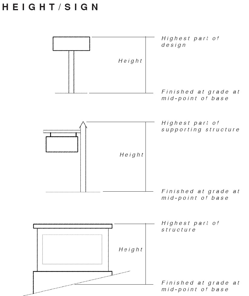
Height, freestanding sign. The vertical distance between the highest part of the sign or its supporting structure, whichever is higher, and finished grade at the midpoint of the base of the sign.
Height, other structure. The vertical distance from the existing grade to the highest point of the structure above such existing grade. For example—with billboards, this measurement shall be used to determine appropriate height of the sign structure in relation to the adjacent road grade of the street the sign is facing. With buildings, this definition shall be interpreted literally.
Home occupation. Any use conducted entirely within a dwelling and carried on by the occupants thereof, which use is incidental and secondary to the use of the dwelling for residential purposes and does not change the character of the dwelling or the neighborhood.
Illicit connection. Any unlawful connection which allows the discharge of non-stormwater to the stormwater conveyance system or waters of the state in violation of this ordinance.
Illicit discharge. Any unlawful disposal, placement, emptying, dumping, spillage, leakage, pumping, pouring, emission, or other discharge of any substance other than stormwater into a stormwater conveyance, the water of the state, or upon the land in such proximity to the same, such that the substance is likely to reach a stormwater conveyance or the waters of the state.
Impact. The effect of one land use upon another as measured by traffic or noise generation, site activity, hours of operation, site lighting, vibration, smoke or odor emissions, or similar factors.
Impervious surface. Improvements including street pavement, driveways, buildings, and other structures that cover the soil surface and prevent infiltration of water into the soil.
Impervious surface coverage. That portion of a lot covered by buildings, structures, paving or other impervious surface materials.
Industrial development. Any non-residential development that requires an NPDES permit for an industrial discharge and/or requires the use or storage of any hazardous material for the purpose of manufacturing, assembling, finishing, cleaning, or developing any product or commodity.
Industrial discharge. The discharge of industrial process treated wastewater or wastewater other than sewage and including:
a.
Wastewater resulting from any process of industry or manufacture, or from the development of any natural resource;
b.
Wastewater resulting from processes of trade or business, including wastewater from laundromats and car washes, but not wastewater from restaurants;
c.
Stormwater contaminated with industrial wastewater; and
d.
Wastewater discharged from a municipal wastewater treatment plant requiring a pretreatment program.
Industry, heavy. A use engaged in the basic processing and manufacturing of materials or products predominately from extracted or raw materials, or a use engaged in the storage of or manufacturing processes using flammable or explosive materials, or storage or manufacturing processes that potentially involve hazardous or commonly recognized offensive conditions.
Industry, light. Research and development activities, the manufacturing, compounding, processing, packaging, storage, assembly, and /or treatment of finished or semi-finished products from previously prepared materials, which activities are conducted wholly within an enclosed building. Light industry typically involves land uses operated in such a manner as to control external effects of the manufacturing process, such as smoke, noise, soot, dirt, vibration, odor, etc.
Integrated multiple use development (IMUD). A development containing three or more stores, service establishments, offices, or other permitted uses planned, organized, and managed to function as a unified whole and featuring all of the following: 1) common driveways, 2) common parking, 3) common signage plan, and 4) common landscaping plan. Examples are shopping centers and office parks having the characteristics listed above. Such integrated developments may include outparcels for lease or for sale. Any such integrated development may be organized as a condominium or in a manner analogous to that of a townhouse development (with ownership parcels beneath the building units and with parking and driveways being in common elements owned and maintained by an owners' association).
Junk/salvage yard. Any land or area used, in whole or in part, for the storage, keeping, or accumulation of material, including scrap metals, wastepaper, rags, or other scrap materials, or used building materials, for the dismantling, demolition or abandonment of automobiles or other vehicles or machinery or parts thereof.
Junked automobile. See "motor vehicle, junked."
Land disturbing activity. Any use of land in residential, industrial, educational, institutional, or commercial development, highway or road construction or maintenance, that results in a change in natural cover or topography that causes or contributes to sedimentation.
Landfill. A facility for the disposal of solid waste on land in a sanitary manner in accordance with G.S. ch. 130A art. 9. For the purpose of these watershed provisions, this term does not include composting facilities.
Landfill, demolition and construction debris (major). A disposal site other than minor demolition and construction debris landfill as defined in this ordinance for stumps, limbs, leaves, concrete, brick, wood, and uncontaminated earth. Disposal of any other types of wastes must be approved by the state division of health services.
Landfill, demolition and construction debris (minor). A disposal site for stumps, limbs, leaves, concrete, brick, wood, and uncontaminated earth which is less than three acres in size and is in operation for less than one year.
Landfill, sanitary/solid waste. A site for solid waste disposal from residential, industrial, or commercial activities.
Lighting, accent. Lighting intended to accentuate an architectural feature such as a window, roofline, or other vertical or horizontal element and consisting of small, non-flashing white lights.
Limited agriculture. The keeping of gardens and animals for non-commercial domestic use. Such agriculture generally refers to but is not limited to, domestic fowl such as chickens, turkeys, ducks and geese, bees, and other small animals (e.g., rabbits). Limited agriculture does not permit livestock such as horses, cows, llamas, sheep, swine, pot-bellied pigs, or the like.
Lot. A portion of a subdivision or any other parcel of land intended as a unit for transfer of ownership or for development or both. The word "lot" includes "plot," "parcel," or "tract."
Lot, corner. A lot abutting two or more streets at their intersection.
Lot, depth. The distance measured along the perpendicular bisector of the smallest possible rectangle enclosing the lot.
Lot of record. A lot, plot, parcel or tract recorded in the office of the register of deeds in conformance with the ordinance(s) in effect at the time of recordation.
Lot, reverse frontage. A through lot which is not accessible from one of the parallel or nonintersecting streets upon which it fronts.
Lot, through. A lot abutting two streets that do not intersect at the corner of the lot.
Lot width. The mean width measured at right angles to its depth at the building front setback line.
Lowest adjacent grade (LAG). The elevation of the ground, sidewalk or patio slab immediately next to the building, or deck support, after completion of the building.
Lowest floor. The lowest floor of the lowest enclosed area (including basement). An unfinished or flood-resistant enclosure, usable solely for parking of vehicles, building access, or limited storage in an area other than a basement area is not considered a building's lowest floor, provided that such an enclosure is not built so as to render the structure in violation of the applicable non-elevation design requirements of this ordinance.
Maintenance (of a sign). Cleaning, painting, repairing, or replacing defective parts in such a manner that does not alter the basic structure of a sign. This definition includes the changing of the copy or listings on a changeable copy, civic event, sandwich board, or directory sign and the replacement of sign copy with other sign copy of the same or smaller size on other permitted signs.
Major watershed variance. A variance from the minimum statewide watershed protection rules that results in the relaxation by a factor greater than five percent of any buffer, density, or built-upon area requirement under the high-density option; any variation in the design, maintenance or operation requirements of a wet detention pond or other approved stormwater management system; or relaxation by a factor greater than ten percent of any management requirement under the low-density option.
Manufactured home. A structure, transportable in one or more sections, which in the traveling mode is eight body feet or more in width, or 40 body feet or more in length, or, when erected on site, is 320 or more square feet; and which is built on a permanent chassis and designed to be used as a dwelling, with or without a permanent foundation when connected to the required utilities, including the plumbing, heating, air conditioning and electrical systems contained therein. For manufactured homes built before June 15, 1976, "manufactured home" means a portable manufactured housing unit designed for transportation on its own chassis and placement on a temporary or semi-permanent foundation having a measurement of over 32 feet in length and over eight feet in width. "Manufactured home" also means a double-wide manufactured home, which is two or more portable manufactured housing units designed for transportation on their own chassis that connect on-site for placement on a temporary or semi-permanent foundation having a measurement of over 32 feet in length and over eight feet in width. The term "manufactured home" does not include a recreational vehicle.
Manufactured home park or subdivision. A site with required improvements and utilities for the long-term placement of manufactured homes which may include services and facilities for the residents.
Market value. The building value, not including the land value, and that of any accessory structures or other improvements on the lot. Market value may be established by independent certified appraisal; replacement cost depreciated for the age of building and quality of construction (actual cash value); or adjusted tax assessed values.
Mean sea level. For purposes of this ordinance, the National Geodetic Vertical Datum (NGVD) as correct in 1929, the North American Vertical Datum (NAVD) as correct in 1988, or other vertical control datum used as a reference for establishing varying elevations within the floodplain, to which base flood elevations (BFEs) shown on a FIRM are referenced. Refer to each FIRM panel to determine datum used.
Minor watershed variance. A variance from the minimum statewide watershed protection rules that results in the relaxation by a factor of up to five percent of any buffer, density, or built-upon area requirements under the high-density option; or relaxation by a factor of ten percent of any management requirement under the low-density option.
Mixed development. A mixture of residential and permitted office and/or commercial uses.
Mixed-use development. The combination of complementary land uses in an integrated fashion through the development of a tract of land, building, or structure.
Modular housing. A dwelling constructed in accordance with the standards set forth in the N.C. State Residential Building Code and composed of components substantially assembled in a manufacturing plant and transported to the building site for final assembly on a permanent foundation.
Motor vehicle, junked. A motor vehicle that does not display a current license plate and is one or more of the following: 1) is partially dismantled or wrecked; or 2) cannot be self-propelled or moved in the manner in which it originally was intended to move; or 3) is more than five years old and appears to be worth less than $100.00.
Multifamily dwelling. A building or portion thereof used or designed as a residence for three or more families living independently of each other with separate housekeeping and cooking facilities for each, and includes apartment, townhouses, and condominiums.
Municipal separate storm sewer system (MS4). A stormwater conveyance or unified stormwater conveyance system (including without limitation: roads with drainage systems, municipal streets, catch basins, stormwater detention facilities, curbs, gutters, ditches, natural or man-made channels, or storm drains), that:
a
Are located within the corporate limits of the Town of Jamestown, North Carolina or in the extraterritorial jurisdiction (ETJ) of the Town of Jamestown, North Carolina;
b.
Is owned or operated by the state, county, the Town, or other public body; and
c.
Discharges to waters of the state, excluding publicly owned treatment works, and lawful connections thereto, which in turn discharge into the waters of the state.
National pollutant discharge elimination system. A permitting system established pursuant to 402 of the Clean Water Act.
Neckdown. Constructed features designed and placed to narrow the width of traffic lanes in order to slow the speed of traffic on town streets. Curb bulbs and chicanes may be used for this purpose.
Neighborhood. An area of the Town with characteristics that distinguish it from others including distinct economic bases, housing types, schools, development styles or patterns, or boundaries defined by distinct physical barriers such as railroads, arterial streets, rivers, or major water bodies.
Neighborhood plan. The plan officially adopted by the Jamestown Town Council for a particular neighborhood or district that provides specific design standards and guidelines regulating the development and use of the property.
New construction. Structures for which the "start of construction" commenced on or after the effective date of the original version of the community's Flood Damage Prevention Ordinance and includes any subsequent improvements to such structures. (This definition applies only with respect to flood hazard regulations.)
New development. Any land-disturbing activity which adds to or changes the amount of built-upon area. (This definition applies only with respect to watershed protection regulations.)
Nonconforming use. Any nonconformity involving the use of the property. This may include, without limitation, nonconformities associated with a use not permitted in the zoning district in which it is located or a use conditionally allowed in the zoning districts in which it is located but for which no special use permit has been obtained.
Nonconformity, dimensional. Any nonconformity involving a dimensional or numerical development requirement except those involving signs which are addressed in Article 17. Dimensional nonconformities may include, without limitation, nonconformities associated with density, landscaping, buffering, lot size, lot width, lot depth, setbacks, height, structure size standards, impervious surface standards, open space, number of parking spaces, or separation requirements between particular uses or zoning districts.
Nonconformity, lawful. Any nonconformity involving a dimensional or numerical requirement or use of property that affects a structure erected or a lot created in conformity with the then-applicable development requirements of the city, but subsequently made nonconforming by action of the Town through a zoning map or Unified Development Code amendment.
Nonencroachment area. The channel of a river or other watercourse and the adjacent land areas that must be reserved in order to discharge the base flood without cumulatively increasing the water surface elevation more than one foot as designated in the Flood Insurance Study report.
Nonprocess discharge. Industrial effluent not directly resulting from the manufacturing process. An example is noncontact cooling water from a compressor.
Nursing home. An establishment that provides full-time convalescent or chronic care, or both, who are not related by blood or marriage to the operator or who, by reason of advanced age, chronic illness or infirmity, are unable to care for themselves.
Occupancy. A separately leased or owned area within a building having ground level frontage on a right-of-way or parking facility.
Off-premises. Not located on the property to which it pertains.
Office warehouse. A land use that includes offices that support showroom or warehouse uses.
On-premises. Located on the property to which it pertains.
On-premises consumption. The consumption of a product within any area, whether inside or outside a permanent or temporary building or structure as defined in these ordinances, where the user of a property has control of the property through a lease, deed, or other legal process.
OPA. An otherwise protected area.
Open space. Any publicly dedicated or privately owned area of land or water that is permanently preserved and maintained. Such an area may be predominately in a natural condition or modified for uses such as recreation, education, aesthetics, cultural or natural resource management or public health and safety.
Passive recreation element. Trials, open space, uncovered picnic areas, and similar facilities provided for recreational use.
Perennial and intermittent streams. Those streams (and rivers), with associated lakes and ponds as indicated on the following:
a.
On the most recent version of the United States Geological Survey 1:24,000 scale (7.5-minute quadrangle) topographical map;
b.
On the most recent version of the Soil Survey of Davidson County, Forsyth County, Guilford County, or Randolph County developed by the United States Department of Agriculture (USDA) Natural Resource Conservation Service (formerly the USDA Soil Conservation Service); or
c.
By other site-specific evidence that indicates to the North Carolina Division of Water Quality (DWQ) the presence of such waters not shown on either of these two maps or evidence that no actual stream or waterbody exists.
Plan, sketch. A rough sketch map of a proposed subdivision or site showing streets, lots, and any other information required by the Town of sufficient accuracy used for discussion of the street system and the proposed development pattern.
Planned community. Real estate with respect to which any person, by virtue of that person's ownership of a lot, is expressly obligated by a declaration to pay real property taxes, insurance premiums, or other expenses to maintain, improve, or benefit other lots or other real estate described in the declaration. For purposes of this act, neither a cooperative nor a condominium is a planned community, but real estate comprising a condominium or cooperative may be part of a planned community. "Ownership of a lot" does not include holding a leasehold interest of less than 20 years in a lot, including renewal options.
Planned unit development. An area of land under unified ownership or control to be developed and improved as a single entity under a Unified Development Plan in accordance with and subject to the requirements of this ordinance.
Planning director. The Town of Jamestown official charged with administering, interpreting, and enforcing the Land Development Ordinance, including the sign regulations, or his/her designee.
Plat. A surveyed map or plan of a parcel of land which is to be or has been subdivided.
Plat, final. The final map of all or a portion of a subdivision or site plan, showing the boundaries and location of lots, streets, easements and other requirements of the Town, which is presented for approval by the town council and subsequent recording in the Guilford County Register of Deeds Office.
Plat, preliminary. A map indicating the proposed layout of the subdivision or site showing lots, streets, water, sewer, storm drainage, and any other requirements of the Town, which is presented for preliminary approval.
Pollution. Man-made or man-induced alteration of the chemical, physical, biological, thermal, and/or radiological integrity of water.
Portable storage unit (POD). A transportable unit designed and used for the temporary storage of household goods, personal items, and other materials which is placed on a site of the use of occupants of a dwelling or building on a limited basis. Such containers are uniquely designed for their east of loading to and from a transport vehicle.
Post-firm. Construction or other development for which the "start of construction" occurred on or after the effective date of the initial flood insurance rate map for the area.
Pre-firm. Construction or other development for which the "start of construction" occurred before the effective date of the initial flood insurance rate map for the area.
Premises. All areas, whether inside or outside a permanent or temporary building or structure as defined in these ordinances, where the user of a property has control of the property through a lease, deed, or other legal process.
Principally above ground. That at least 51 percent of the actual cash value of the structure is above ground.
Principal structure. A structure (or structures) in which the principal use of the lot or property is conducted.
Principal use. The primary use of any lot or property.
Professional office. The office of a member of a recognized profession maintained for the conduct of that profession, including, but not limited to, the offices of doctors, lawyers, dentists, landscape architects, architects, stockbrokers and financial analysts, chiropractors, engineers, surveyors, or city planners.
Protected drainageway (channel). Where drainage is channeled by pervious devices such as sod waterways, berms, channels or swales which have been constructed to resist soil erosion by either vegetating, netting, riprapping, or a combination of those, and which allows infiltration of water into the soil.
Public open space. Open space that is accessible to the general public and maintained by the Town.
Public safety and/or nuisance. Anything injurious to the safety or health of an entire community or neighborhood, or any considerable number of persons, or unlawfully obstructs the free passage or use, in a customary manner, of any navigable lake, or river, bay, stream, canal, or basin. (This definition applies only to flood hazard regulations.)
Recreational vehicle. A vehicle which is built on a single chassis, 400 square feet or less, when measured at the largest horizontal projection, designed to be self-propelled or permanently towable by a light-duty vehicle, and designed primarily for use not as a permanent dwelling but as temporary living quarters for recreational, camping, travel or seasonal use.
Recreational vehicle park. Any site or tract of land, of contiguous ownership, upon which 15 or more recreational vehicles or tent spaces are provided for occupancy according to the requirements set forth in this ordinance.
Reference level. The top of the lowest floor for structures within special flood hazard areas designated as Zone A1.A30, AE, A, or A99.
Regulatory flood protection elevation. The "base flood elevation" plus the "freeboard." In "special flood hazard areas" where base flood elevations (BFEs) have been determined, this elevation shall be the BFE plus two feet of freeboard. In "special flood hazard areas" where no BFE has been established, this elevation shall be at least two feet above the highest adjacent grade.
Regulating plan. A master development plan for a site, parcel, or property, meeting the standards of the Town of Jamestown and identifying buildings, parking, and landscape locations, open spaces, trails, other amenities, and other features as required by the Town. Upon its approval by the Jamestown Town Council, the plan becomes the guide for the development of the property and all development activity on the property must comply with the plan.
Remedy a violation. To bring the structure or other development into compliance with state and community floodplains management regulations, or, if this is not possible, to reduce the impacts of its noncompliance. Ways that impact may be reduced include protecting the structure of other affected development from flood damages, implementing the enforcement provisions of the ordinance or otherwise deterring future similar violations, or reducing federal financial exposure with regard to the structure or other development. (This definition applies only with respect to flood hazard regulations.)
Renovation. The repairing or remodeling of a structure in which the exterior walls, foundation, and roof are maintained structurally intact.
Required drainage channel. The theoretical stream bed section which is required to carry and discharge the runoff from a 100-year storm.
Research and technology production uses. Uses such as medical, optical and scientific research facilities, software production and development, clinics and laboratories, pharmaceutical compounding and photographic processing facilities, and facilities for the assembly of electronic components, optical equipment, and precision instruments.
Residential development. Buildings for use as residences such as attached and detached single-family dwellings, apartment complexes, condominiums, townhouses, cottages, etc., and their associated outbuildings such as garages, storage buildings, gazebos, etc., and customary home occupations.
Retention pond. A wet or dry stormwater holding area, either natural or manmade, which has a permanent pool and does not release stormwater to nearby or adjoining water bodies. See also "best management practices" definition.
Riverine. Relating to, formed by, or resembling a river (including tributaries), stream, brook, etc.
Roofline. The top edge of the roof or the top of the parapet, whichever forms the top line of the building silhouette.
Runoff detention equal to minimum requirements. Velocity control of runoff.
Salvage yard. Any non-residential property used for the storage, collection, and/or recycling of any type of equipment, and including but not limited to vehicles, appliances and related machinery.
Salvage yard, auto parts. Any establishment listed in the Standard Industrial Classification manual under Industry Number 5015. Also, any land or area used, in whole or part, for the storage, keeping accumulation, dismantling, demolition, or abandonment of inoperable vehicles or parts therefrom.
Salvage yard, scrap processing. Any establishment listed in the Standard Industrial Classification Manual under Industry Number 5093. Also, any land or area used, in whole or part, for the storage, keeping, accumulation of scrap or waste materials, including scrap metals, waste paper, rags, building materials, machinery, or other scrap materials.
Scenic corridor. An area providing scenic vistas visible from a highway or roadway that is designated by the Town of Jamestown as having special importance to the character of the Town and meriting special protection and preservation measures as a consequence.
Searchlight. A device that emits an upwardly directed beam of light to attract commercial attention.
Sediment. Solid particulate matter, both mineral and organic, that has been or is being transported by water, air, gravity, or ice from its site of origin.
Sedimentation. The process by which sediment resulting from accelerated erosion has been or is being transported off the site of the land-disturbing activity or into a lake or natural watercourse.
Setback. The minimum required horizontal distance between a structure or activity and the property line, street right-of-way line, or street centerline.
Setback, rear. A setback from an interior property line lying on the opposite side of the lot from the front street setback.
Setback, side. Any interior property line setback other than a rear setback.
Setback, street. Any setback from a street, road, or lane.
Setback, zero side. An alternate form of dimensional requirements that allows a dwelling unit to have one side setback of zero feet from a side property line. This definition does not include townhouses.
Shear wall. Walls used for structural support but not structurally joined or enclosed at the end (except by breakaway walls). Shear walls are parallel or nearly parallel to the flow of the water.
Sign. A communications medium, method, device, structure, or fixture that incorporates motion, lighting, graphics, symbols, or written copy intended to promote the sale of a product, commodity, or service, or to provide direction to or identification of a neighborhood, premises, event or facility.
Sign alteration. Any change to the size, shape, illumination, position, location, or construction of a sign or the supporting structure of a sign.
Sign area. The size of a sign in square feet as computed by the area of not more than two standard geometric shapes (specifically, circles, squares, rectangles, or triangles) that encompass the shape of the sign exclusive of the supporting structure.
Example Illustrating Measurement of the Area of an Irregularly Shaped Sign
Sign copy. Any graphic design, letter, numeral, symbol, figure, device or other media used separately or in a combination that is intended to advertise, identify or notify, including the panel or background on which such media is placed.
Sign face. The side or sides of a sign on which a message is placed.
Sign illumination, types of.
•
Ambient. Illumination of a sign by light from the sign's general surroundings, such as daylight or nearby streetlights.
•
External. Illumination of a sign by a source of light located exterior to the sign, such as a floodlight.
•
Internal. Illumination of a sign by a source of light contained within the sign itself.
Sign, nonconforming. A sign that does not conform to one or more requirements of Article 17.
Sign types.
•
Sign, awning. A sign incorporated into or attached to an awning.
•
Sign, blade (or projecting). A sign attached to and projecting from the building façade, typically at right angles to the building.
•
Sign, canopy. A sign incorporated into or attached to a canopy.
•
Sign, changeable copy. A sign or portion thereof designed to accommodate frequent copy changes through manual, mechanical or digital means.
•
Sign, civic. A temporary sign posted on the premises of a property that contains a civic use, such as a religious institution, educational institution, or similar civic use.
•
Sign, directional. A sign intended to guide the circulation of motorists or pedestrians entering, exiting, or on a site, including signs marking entrances and exits, parking areas, loading zones, or circulation patterns.
•
Sign, directory. A sign listing that is intended to provide on-site directions.
•
Sign, exempt. A sign identified in Article 17, section six that is exempt from the requirements of this ordinance, either conditionally or unconditionally.
•
Sign, flat (or wall). A sign attached directly to and generally parallel with the façade of a building.
•
Sign, incidental. A sign, whose purpose is secondary to the use of the premises on which it is located.
•
Sign, machine. A sign attached to a machine such as a gasoline pump, a drive-through menu kiosk, a soft drink dispensing machine, or an ATM.
•
Sign, model home. A sign located on the premises of a home model of a type that is available for sale in a subdivision.
•
Sign, monument (or ground). A freestanding sign supported by a structure that is at least as wide as the sign to which it is attached.
•
Sign, outdoor advertising (or billboard). A sign as defined in G.S. § 136-128.
•
Sign, permanent. A sign intended or designed for permanent display and permitted as such.
•
Sign, pole. A freestanding sign supported by a structure consisting of not more than two poles.
•
Sign, sandwich board (or A-frame). A temporary freestanding sign designed and displayed to provide information to pedestrians.
•
Sign, snipe. A temporary sign not otherwise defined in this article that is tacked, nailed posted, glazed, or otherwise affixed to a light fixture, utility pole, public building, fence, railing, public telephone pole, traffic control device, or tree or to the ground.
•
Sign, temporary. A sign not intended or designed for permanent display and permitted as such.
•
Sign, V-type. An attached sign consisting of two separate faces arranged in a "V" pattern and having an angle of 120 degrees or less as measured from the side attached to the building.
•
Sign, window. A sign attached to a display window or door window that is intended to be viewed from the exterior. This definition shall include signs attached to the interior of a display window or door window.
•
Sign, yard. A small sign, not exceeding six square feet, that is temporary, self-supporting, and is typically associated with a residential dwelling.
Siltation. Sediment resulting from accelerated erosion which is settleable or removable by properly designed, constructed, and maintained control measures; and which has been transported from its point of origin within the site of a land-disturbing activity, and which has been deposited, or is in suspension in water.
Single family residential. Any development where: 1) no building contains more than one dwelling unit, 2) every dwelling unit is on a separate lot, and 3) where no lot contains more than one dwelling unit.
Site plan. A plan, drawn to scale, showing uses and structures proposed for a parcel of land as required by the regulations, such as lot lines, streets, building sites, reserved open space, buildings, major landscape features, both natural and manmade, and the locations of proposed utility lines.
Site-specific development plan. A plan that has been submitted to the Town by a landowner describing with reasonable certainty the type and intensity of use for a specific parcel or parcels of property. Such plan may be in the form of, but not limited to, any of the following plans or approvals: A subdivision plat, a preliminary or general development plan, a special use permit, a conditional district zoning plan, or any other land-use approval designation as may be utilized by the Town. Such a plan shall include the approximate boundaries of the site; significant topographical and other natural features affecting the development of the site; the approximate location on the site of the proposed buildings, structures, and other improvements; the approximate dimensions, including height, of the proposed building and other structures; the approximate location of all existing and proposed infrastructure on the site, including water, sewer, roads, and pedestrian walkways; and any other information required by the Town for the type of plan or approval requested by the landowner. A variance shall not constitute a site-specific development plan. Neither a sketch plan nor any other document which fails to describe with reasonable certainty the type and intensity of use for a specific parcel or parcels of property may constitute a site-specific development plan.
Sludge. Any solid or semisolid waste generated from a wastewater treatment plant, water treatment plant, or air pollution control facility permitted under authority of the North Carolina Environmental Management Commission.
Solid waste disposal facility. Any facility involved in the disposal of solid waste as defined in G.S. § 130A-290(a)(35).
Solid waste disposal site. As defined in G.S. § 130A-290(a)(36), any place at which solid wastes are disposed of by incineration, sanitary landfill, or any other method.
Special events facility. See "banquet facility."
Special flood hazard area (SFHA). The land in the floodplain subject to a one percent or greater chance of being flooded in any given year, as determined in Section 12.5(B) of this ordinance.
Stabilizing vegetation. Any vegetation that prevents accelerated soil erosion.
Start of construction. Includes substantial improvement and means the date of the building permit was issued, provided the actual start of construction, repair, reconstruction, rehabilitation, addition placement, or other improvement was within 180 days of the permit date. The actual start means either the first placement of permanent construction of a structure on a site, such as the pouring of slab or footings, the installation of piers, the construction of columns, or any work beyond the stage of excavation; or the placement of a manufactured home on a foundation. Permanent construction does not include land preparation, such as clearing, grading, and filling; nor does it include the installation of streets and/or walkways; nor does it include excavation for a basement, footings, piers, or foundations or the erection of temporary forms; nor does it include the installation on the property accessory buildings, such as garages or sheds not occupied as dwelling units or not part of the main structure. For a substantial improvement, the actual start of construction means the first alteration of any wall ceiling, floor, or other structural part of the building, whether or not that alteration affects the external dimensions of the building. (This definition applies only with respect to flood hazard regulations.)
Storm, ten-year. The surface runoff resulting from a rainfall of an intensity expected to be equaled or exceeded, on the average, once in ten years and of a duration which will produce the maximum peak rate of runoff for the watershed of interest under average antecedent wetness conditions.
Storm, 100-year. The surface runoff resulting from a rainfall of an intensity expected to be equaled or exceeded, on the average, once in 100 years and of a duration which will produce the maximum peak rate of runoff for the watershed of interest under average antecedent wetness conditions.
Storm drainage facilities. The system of inlets, conduits, channels, ditches, and appurtenances which serve to collect and convey stormwater through and from a given drainage area.
Stormwater. Any flow resulting from, and occurring during or following, any form of natural precipitation.
Stormwater conveyance or stormwater conveyance system. Any feature, natural or man-made, that collects and transports stormwater, including but not limited to roads with drainage systems, streets, catch basins, curbs, gutters, ditches, man-made or natural channels, pipes, culverts, and storm drains, and any other natural or man-made feature or structure designed or used for collecting or conveying stormwater.
Stormwater runoff. The direct runoff of water resulting from precipitation in any form.
Stream. A watercourse that collects surface runoff.
Stream buffer. A natural, vegetated, or vegetated area through which stormwater runoff flows in a diffuse manner so that the runoff does not become channelized and which provides for infiltration of the runoff and filtering of pollutants. The buffer width is measured landward from the normal pool elevation of impoundments and from the bank of each side of streams or rivers. (This definition applies only with respect to Watershed Protection Regulations).
Street, local. A street whose primary function is to provide access to abutting properties.
Street, major thoroughfare. Major thoroughfares consist of interstate, other freeway, expressway, or parkway links, and major streets that provide for the expeditious movement of high volumes of traffic within and through urban areas.
Street, minor thoroughfare. Minor thoroughfares collect traffic from collector, subcollector, and local streets and carry it to the major thoroughfare system. Minor thoroughfares may be used to supplement the major thoroughfare system by facilitating movement of moderate volumes of traffic within and through urban areas and may also serve abutting property.
Street, private. A vehicular travelway not dedicated or offered for dedication as a public street but resembling a cul-de-sac or a local street by carrying traffic from a series of driveways to the public street system.
Street, public. A dedicated public right-of-way for vehicular traffic which: (1) has been accepted by NCDOT for maintenance, or (2) is not yet accepted, but in which the roadway design and construction have been approved under public standards for vehicular traffic. Alleys are specifically excluded from this definition.
Street, right-of-way. A strip of land occupied or intended to be occupied by a travelway for vehicles and also available, with the consent of the appropriate governmental agency, for installation and maintenance of sidewalks, traffic control devices, traffic signs, street name signs, historical marker signs, water lines, sanitary sewer lines, storm sewer lines, gas lines, power lines, and communication lines.
Street, subcollector. A street whose principal function is to provide access to abutting properties but which is also designed to be used or is used to connect local streets with collector or higher classification streets.
Structure. A walled and roofed building, a manufactured home, or a gas, liquid, or liquefied gas storage tank that is principally above ground. (This definition applies only with respect to flood hazard regulations.)
Subdivision. The division of land into two or more lots by a plat and recorded with the county clerk and register of deeds.
Subdivision, major. Any non-residential subdivision; or a residential subdivision involving more than four lots, or requiring new public street(s) for access to interior property, or requiring extension of public sewage or water line, or requiring a waiver or variance from any requirement of this ordinance.
Subdivision, minor. A residential subdivision involving four or fewer lots fronting on an existing approved public street(s), not requiring any new public or private street(s) for access to interior property, not requiring extension of public sewage or water line, and not requiring a waiver, modification, or variance from any requirement of this ordinance.
Substantial damage. Damage of any origin sustained by a structure during any one-year period whereby the cost of restoring the structure to its before damaged condition would equal or exceed 50 percent of the market value of the structure before the damage occurred. See definition of "substantial improvement." Substantial damage also means flood-related damage sustained by a structure on two separate occasions during a ten-year period for which the cost of repairs at the time of each such flood event, on the average, equals or exceeds 25 percent of the market value of the structure before the damage occurred. (This definition applies only with respect to flood hazard regulations.)
Substantial improvement. Any combination of repairs, reconstruction, rehabilitation, addition, or other improvement of a structure, taking place during any one-year period for which the cost equals or exceeds 50 percent of the market value of the structure before the "start of construction" of the improvement. This term includes structures that have incurred "substantial damage," regardless of the actual repair work performed. The term does not, however, include either:
a.
Any correction of existing violations of state or community health, sanitary, or safety code specifications which have been identified by the community code enforcement officials and which are the minimum necessary to assure safe living conditions; or
b.
Any alteration of a historic structure, provided that the alteration will not preclude the structure's continued designation as a historic structure.
Substantially similar. The same or significantly the same as a prior plan or application as determined by the associated land area, the intensity of development proposed, the range of proposed uses, the type, variety, and scale of signage, and other relevant factors.
Suburban open space amenities. Land available for active or passive recreation including parks, trails, clubhouses, playgrounds, athletic fields and courts, picnic facilities, benches, community gardens, and pools. It can include natural areas including floodplains, waterbodies, wetlands, woodlands, land used for stormwater retention, and slopes over 15 percent.
Surface water buffer. A natural, vegetated, or re-vegetated area through which stormwater runoff flows in a diffuse manner so that the runoff does not become channelized and which provides for infiltration of the runoff and filtering of pollutants. The buffer width is measured landward from the normal pool elevation of impoundments and from the bank of each side of streams or rivers. (This definition applies only with respect to watershed protection regulations.)
Tailgate market. The permanent or regularly periodic offering for sale of fresh agricultural products directly to the consumer at an open-air market.
Tattoo and body-piercing studio. A facility where tattooing (as defined in G.S. § 130A-283) is engaged in or where the business of tattooing is conducted or any part thereof.
Telecommunications tower. For definitions, please see Article 25, Wireless telecommunications facilities or complexes.
Temporary health care structure. A transportable residential structure, providing an environment facilitating a caregiver's provision of care for a mentally or physically impaired person, that (i) is primarily assembled at a location other than its site of installation, (ii) is limited to one occupant who shall be the mentally or physically impaired person, (iii) has no more than 300 gross square feet, and (iv) complies with applicable provisions of the State Building Code and G.S. § 143-139.1(b). Placing the temporary family health care structure on a permanent foundation shall not be required or permitted.
Theater, adult. An enclosed building or premises used for presenting motion pictures, a preponderance of which are distinguished or characterized by an emphasis on matter depicting, describing or relating to sexual activities or anatomical areas.
Thoroughfare plan. A plan adopted by the governing body for the development of existing and proposed major streets that will adequately serve the future travel needs of an area in an efficient and cost-effective manner.
Tobacco product. As defined in G.S. § 14-313, any product that contains tobacco and is intended for human consumption. The term includes a tobacco-derived product, vapor product, or components of a vapor product.
Tobacco derived product. As defined in G.S. § 14-313, any noncombustible product derived from tobacco that contains nicotine and is intended for human consumption, whether chewed, absorbed, dissolved, ingested, or by other means. The term does not include a vapor product or any product regulated by the United States Food and Drug Administration under Chapter V of the Federal Food, Drug, and Cosmetic Act.
Tobacco shop, retail. Consistent with G.S. § 130A-492, a business establishment primarily engaged in the retail sale of tobacco, tobacco products, and accessories for such products, that received no less than 75 percent of its total annual revenues from the sale of tobacco, tobacco products, and accessories for such products, for off-premise consumption. "Tobacco Shop" does not include establishments that offer gathering areas common to vaping shops and hookah lounges.
Tobacco shop with lounge. Consistent with G.S. § 130A-492A business establishment engaged in the retail sale and on-premise consumption of tobacco, tobacco products, and accessories for products, that receives no less than 75 percent of its total annual revenues from the sale of tobacco, tobacco products, and accessories for such products. Establishments such as hookah lounges and cafes and vaping lounges and Cafes are included in this definition. Establishments with a permit to sell alcoholic beverages are not included in this definition.
Tourist home. A private residence in which accommodations are provided for lodging and may include meals for overnight guests for a fee.
Townhouse. Single occupancy units attached to one another in which each unit is located on an individually owned parcel, generally within a development containing drives, walks and open areas owned in common.
Townhouse lot. A parcel of land intended as a unit for transfer of ownership and lying underneath, or underneath and around, a townhouse, patio home, or unit in nonresidential group development.
Toxic substance. Any substance or combination of substances (including disease-causing agents), which after discharge and upon exposure, ingestion, inhalation, or assimilation into any organism, either directly from the environment or indirectly by ingestion through food chains, has the potential to cause death, disease, behavioral abnormalities, cancer, genetic mutations, physiological malfunctions (including malfunctions or suppression in reproduction or growth) or physical deformities in such organisms or their off spring or other adverse health effects.
Tract. All contiguous land and bodies of water in one ownership, or contiguous land and bodies of water in diverse ownership being developed as a unit, although not necessarily all at one time.
Tree, canopy. A species of tree which normally grows to a mature height of 40 feet or more with a minimum mature crown of 30 feet.
Tree, understory. A species of tree which normally grows to a mature height of 15 to 35 feet in height.
Typical required drainage channel section. A cross-sectional view of a required drainage channel.
Undisturbed area. That portion of a lot, tract, or subdivision which has not and will not be occupied and which has not and will not be graded to change land contours or to destroy existing vegetation. Only areas that are wooded or reforested are considered undisturbed for the purposes of watershed protection scoresheet evaluation. (This definition applies only with respect to watershed protection regulations.)
Urban conditions. An area of higher intensity and/or higher density development in which buildings have little or no front and side yard setback, there is significant pedestrian traffic, and on-street parking is permitted. There is typically a mix of uses (residential, office, and retail) in areas with urban conditions.
Urban open space amenities. Facilities for active and passive recreational use located in urban areas that include sidewalks widened beyond what is required by code, plazas, street furniture, outdoor eating or gathering areas, fountains, rooftop gardens, areas featuring public art, or other urban-related amenities.
Use, permitted. A use allowed within the zoning district provided the basic and requirements of the zoning district are met.
Use, special. A use which is generally compatible with other land uses permitted in a zoning district but which, because of its unique characteristics or potential impacts on the surrounding neighborhood and the Town of Jamestown as a whole, requires individual consideration of its location, design, configuration, and/or operation at the particular location proposed.
Use with additional standards. A use permitted by right, provided that the additional standards intended to ensure that the use fits the intent of the zoning districts within which it is permitted and that the use is compatible with other development permitted within the zoning district, are met.
Vapor product. As defined in G.S. § 14-313, any noncombustible product that employs a mechanical heating element, battery, or electronic circuit regardless of shape or size and that can be used to heat a liquid nicotine solution contained in a vapor cartridge. The term includes an electronic cigarette, electronic cigar, electronic cigarillo, and electronic pipe. The term does not include any product regulated by the United States Food and Drug Administration under Chapter V of the federal Food, Drug, and Cosmetic Act.
Variance. Official permission from the board of adjustment to depart from the requirements of this ordinance.
Vegetative buffer. An area meeting regulatory buffer requirements consisting entirely of plant materials that form a screen.
Velocity. The average velocity of flow through the cross-section of the main channel at the peak flow of the storm of interest. The cross section of the main channel shall be that area defined by the geometry of the channel plus the area of flow below the flood height defined by vertical lines at the main channel banks. Overland flows are not to be included for the purpose of computing velocity of flow.
Violation. The failure of a structure or other development to be fully compliant with the community's floodplain management regulations. A structure or other development without the elevation certificate, other certificates, or other evidence of compliance required in Article 18 is presumed to be in violation until such time as that documentation is provided. (This definition applies only with respect to flood hazard regulations.)
Water dependent structures. Structures for which the use requires access or proximity to or siting within surface waters to fulfill its basic purpose, such as boat ramps, boathouses, docks, and bulkheads. Ancillary facilities such as restaurants, outlets for boat supplies, parking lots, and commercial boat storage areas are not water-dependent structures.
Water quality conservation easement. See Section 19.2-2(d), easements.
Water surface elevation (WSE). The height, in relation to mean seal level, of floods of various magnitudes and frequencies in the floodplains of coastal or riverine areas.
Watercourse. A lake, river, creek, stream, wash, channel or other topographic feature on or over which waters flow at least periodically. Watercourse includes specifically designated areas in which substantial flood damage may occur.
Waters of the state. Surface waters within or flowing through the boundaries of the state including the following: any intermittent or perennial stream, river, creek, brook, swamp, lake, sound, tidal estuary, bay, reservoir, wetland, or any other surface water or any portion thereof that is mapped as solid or dashed blue lines on United State Department of the Interior Geological Survey 7.5-minute series topographic maps. Treatment systems, consisting of man-made bodies of water, which were not originally created in waters of the state, which are not the result of impoundment of waters of the state, are not waters of the state.
Watershed critical area. That portion of the watershed within the lake basin of the water supply reservoir as delineated in Article 19 (Watershed Standards).
Watershed, water supply. The entire area contributing drainage to the Town's water supply, in this case Oak Hollow Lake, High Point City Lake, and the proposed Randleman Reservoir. For the purposes of the Watershed Protection Overlay District Regulations, major landmarks such as roads or property lines may be used to delineate the outer boundary of the drainage area if these landmarks are immediately adjacent to the ridgeline.
Wet detention pond. A natural or man-made water body that provides for the storage and gradual release of stormwater runoff by means of a permanent pool of water having an outfall to another water body, and which has a permanent pool that utilizes both settling and biological process to remove both particulate and soluble particulates. See best management practices definition.
Wet retention pond. A natural or man-made water body that provides for the storage of stormwater runoff by means of a permanent pool of water. See best management practices definition.
Wetlands. Those areas that are inundated or saturated by surface or groundwater at a frequency and duration sufficient to support under normal circumstances a prevalence of vegetation typically adapted for life in saturated soil conditions.
Winery, brewery distillery (as accessory use). A facility engaged in the production of manufacturing of beer, wine, or distilled spirits as an ancillary use to an approved use (e.g., as a part of a restaurant facility). Production areas shall not exceed 50 percent of gross floor area.
Winery, brewery distillery (as primary use). A facility engaged in the production of manufacturing of beer, wine, or distilled spirits as the primary use (e.g., micro-brewery with taproom or tasting room). Production areas may exceed 50 percent of gross floor area.
Yard sale (or garage sale). The sale of items outdoors, or from a vehicle, or from a garage or other accessory building, belonging to one or more sponsors of the sale. Only three yard sales per calendar year are permitted on the same zoning lot, unless evidence can be presented of the sale of the lot to a new owner.
Zoning district. An area defined by this ordinance and delineated on the Official Zoning Maps in which the requirements for the use of land and building and development standards are prescribed.
Zoning vested right. A right pursuant to G.S. § 160D-108 to undertake and complete the development and use of property under the terms and conditions of an approved site development plan.