
Maryland Heights City Zoning Code
APPENDIX A
RULES AND DEFINITIONS
A.1.- Rules of construction.
For the purpose of this chapter, certain rules of construction apply to the text, as follows:
A.
Words used in the present tense include the future tense; and the singular includes the plural, unless the context clearly indicates the contrary.
B.
The terms "shall" and "must" are always mandatory and not discretionary; the words "may" or "should" are permissive.
C.
For the purpose of this chapter, certain words and phrases are herein defined. Words and phrases defined herein shall be given the defined meaning. Words and phrases which are not defined shall be given their usual meaning except where the context clearly indicates a different or specified meaning.
D.
The word "person" includes a firm, organization, association, partnership, trust, company, or corporation, as well as an individual.
The words "use or occupy" shall include the words "intended" "designed," or "arranged" to be used or occupied.
A.2. - General definitions.
The following words, terms and phrases, where used in this chapter, shall have the meanings ascribed to them in this section, except when the context clearly indicates a different meaning.
Abutting: To physically touch or border upon; to share a common property line but not overlap. For the purposes of this chapter, a zoning lot line shall be considered to abut a zoning district line even though it may be separated therefrom by a street, parkway, sidewalk, public way, alley, waterway, railroad right-of-way or portion thereof. "Adjacent," "adjoining" and "contiguous" shall have the same meaning as "abutting."
Accessory use: A use incidental to, and on the same lot as, a principal use.
Accessory structure: A subordinate structure detached from but located on the same lot occupied by the main building, the use of which is customarily incidental and subordinate to the main building or use.
Administrative office: An office establishment primarily engaged in overall management and general supervisory functions, such as executive, personnel, finance, legal, and sales activities, performed in a single location or building for other branches or divisions of the same company.
Aisle: The traveled way by which cars enter and depart parking spaces.
Alteration: As applied to a building or structure means a change or re-arrangement in the structural parts; or an enlargement, whether by extending on a side or by increasing in height; or the moving from one location or position to another.
Arbor: See definition in A.4, definitions relating to landscaping design.
Artwork: An original creation of art that involves the application of skill and taste to production of tangible objects, according to aesthetic principles, including but not limited to: sculpture, murals, mosaic, and fountains. These categories may be realized through such mediums as steel, bronze, stained glass, concrete, wood, ceramic tile and stone, as well as other suitable materials.
Athletic field: Outdoor recreational facilities often requiring equipment, designed for formal athletic competition in field sports, such as football, soccer, baseball, softball, and track and field.
Automobile (automotive): As used herein, the term includes passenger cars, motorcycles, vans, pickup trucks, and recreational vehicles.
Automobile sales: The use of any building, land area, or other premise for the display and sale of new or used automobiles, including light trucks or vans. Any automotive repair garage may be conducted as an accessory use to automotive sales.
Automobile service station: Any premises, or portion thereof, used for the retail dispensing or sales of vehicular fuels; light maintenance activities, such as engine tune-ups, lubrication, minor engine repairs are conducted; and including as an accessory use the sale and installation of lubricants, tires, batteries, and similar vehicle accessories.
Automobile wrecking yard: An establishment that cuts up, compresses, or otherwise disposes of motor vehicles.
Automotive garage, repair: Any building, premises, and land in which or upon which a business, service, or industry involving the maintenance, servicing, repair, or painting of vehicle is conducted or rendered.
Awning: A structure that is constructed of fabric or non-rigid materials on a supporting framework projecting from and supported by the exterior wall of a building or structure to which it is attached.
Banking services: Commercial banks as defined in RSMo 362.010, savings and loan as defined in RSMo Ch. 369, credit unions as defined in RSMo Ch. 370, and personal loan businesses governed by RSMo 408.500 and/or RSMo 408.510, excluding financial activities as defined in RSMo Ch. 367.
Bar/tavern (drinking establishment): Premises used primarily for the sale or dispensing of alcoholic beverages by the drink for on-site consumption and where food may be available for consumption by the general public. Food and packaged liquors and beverages may be served or sold only as accessory to the primary use.
Basement: A floored and walled substructure of a building at least fifty (50) percent below the average finished grade of the building.
Bikeway: A bikeway is a path, trail, or paved surface designed for and used by non-motorized bicyclists.
Bioswale: A shallow vegetated basin designed to store and infiltrate stormwater runoff at a specified rate, consisting of a combination of native vegetation, amended soil, sand, and other aggregate materials designed to filter and convey stormwater to a natural or engineered drainage system.
Block: A unit of land within a subdivision bounded by streets or a combination of streets and public land, railroad rights-of-way, waterways or any other barrier to the continuity of development.
Block face: One side of a block. A "block face" includes the portion of a block that abuts a street up to the nearest intersecting street.
Board of adjustment: An officially constituted body established in accordance with RSMo ch. 89 whose principal duties are to hear appeals and, where appropriate, grant variances from the strict application of this chapter.
Buildable area: The area of a lot remaining after the minimum yard and open space requirements of this chapter have been met.
Building: Any structure used or intended to support or house any use or occupancy.
Building commissioner: The officially designated city employee charged with the responsibility for the interpretation, administration, and enforcement of the building code and property maintenance codes, the enforcement of this chapter, and other responsibilities specified by this Code.
Building coverage: The ratio of the horizontal area measured from the exterior surface of the exterior walls of the ground floor of all principal and accessory buildings on a lot to the total lot area.
Building line: A line parallel to a street right-of-way line, edge of a stream, or other property line established on a parcel of land or lot for the purpose of prohibiting construction of a building or structure in the area between such building line and right-of-way, streambank, or other property line.
Building, main or principal: A structure in which the principal use of the lot is conducted.
Building, temporary: A building without any foundation or footings that is intended to be placed or affixed temporarily and which will be removed when the designated time period, activity, or use for which it was erected has ceased.
Buffer strip: Open spaces, landscaped areas, fences, walls, berms, or any combination thereof used to physically separate or screen one use or property from another so as to visually shield or block noise, lights or other nuisances.
Bus shelters: A small, roofed structure, usually having three (3) walls, located near a street and designed primarily for the protection and convenience of bus passengers.
Canopy: A structure that is constructed of rigid materials attached to a building and requiring additional support other than the attachment to the building, or a freestanding structure, with one (1) or more supports, meant to provide shelter from weather elements.
Carport: A roofed structure providing space for the parking of motor vehicles and enclosed on not more than three (3) sides. A carport may be either attached to or detached from a principal structure.
Cemetery: A place for burial of the dead, including crematory facilities as an accessory use.
Church: A building used principally for religious worship, but the word church shall not include or mean an undertaker's chapel or funeral building, a religious educational institution or parochial school, or day care center.
City: The City of Maryland Heights, Missouri.
City council: The officially elected Mayor and City Council of the City of Maryland Heights; the term may be abbreviated in this code as the council.
City engineer: The officially designated or appointed engineer of the city.
City planner: The officially designated city employee charged with the responsibility for the interpretation and administration of this chapter, and other land development ordinances adopted by the city, including the issuance of zoning permits and other responsibilities specified in article 8 of this chapter.
Commercial vehicle: Any vehicle used for commercial purposes (see section 25-14.8, off-street parking restrictions, for restrictions on the parking of commercial vehicles on residential lots).
Community care facility for the elderly: A residential facility that provides residential and personal care services for the elderly and typically includes room, board, supervision and assistance in daily living, such as housekeeping services.
Community/government facility: A building or structure owned, operated or occupied by governmental agency to provide a governmental service to the public.
Comprehensive marijuana dispensaries: A facility licensed by the Missouri Department of Health and Senior Services, or its successor agency, to acquire, process, package, store on site or off site, sell, transport to or from, and deliver marijuana, marijuana seeds, marijuana vegetative cuttings (clones), marijuana-infused products, and drug paraphernalia used to administer marijuana to a qualifying patient or primary caregiver, or to a consumer, anywhere on the licensed property, to a comprehensive facility, a marijuana testing facility, or a medical facility. Transactions may be received by the consumer in person, over the phone, or via the internet (including a third party). The facility's authority to process marijuana shall include the creation of prerolls. All sales must collect the tangible personal property sales tax, in addition to any applicable local tax.
Comprehensive plan: A comprehensive land use plan made and adopted by the planning commission for the City of Maryland Heights which through any combination of text, charts, and maps sets forth proposals for general locations for various land uses, streets, parks, schools, public buildings, utilities and for the physical development of the city.
Condominium: A form of property ownership under the Uniform Condominium Act, RSMo ch. 448, as amended.
Consumption lounge: A permitted premises where cannabis goods and products may be brought for on-site consumption, and consumed by persons twenty-one (21) years of age and over, subject to State regulations as they may change over time.
Convenience store: Any retail establishment offering for sale prepackaged food products, household items, newspapers and magazines, and sandwiches and other freshly prepared foods, such as salads, for off-site consumption.
Convent/monastery: A dwelling owned by a religious order in which no more than five (5) members of that religious order live under strict religious vows and to whom communal living is a substantial component of their religious order and who themselves are engaged in the management or work of health care, residential care, educational or other benevolent institutions.
Data and record storage facility: A building used primarily for the storage of files and records in various forms (paper, tape media, microfilm, computer discs) and available to the general public for a fee.
Day care center: A place which provides shelter and personal care on a regular basis for five (5) or more children who are not related within the third degree computed according to civil law to the operator, for four (4) or more hours per day, whether such place be organized or operated for profit or not. The term "day care center" includes child care facility, kindergarten, nurseries or any other facility that falls within the scope of the definitions set forth above, regardless of auspices.
Dedication: The transfer of property or interest thereto by the owner to another party. Dedication may be affected by formal deeds of conveyance, or by any other method recognized by the laws of the state.
Density, gross: The total number of dwelling units divided by the total project area, expressed as gross dwelling units per acre.
Density, net: The total number of dwelling units divided by the net project area. In determining net density, all land area associated with and accessory to the dwelling unit, including private streets and driveways, off-street parking facilities and common open space and recreational facilities, shall be included in the calculation. Net density calculations exclude rights-of-way of publicly dedicated streets and nonresidential structures, land uses and accessory facilities.
Developer: Any person or government agency undertaking any development as defined in this chapter. The term developer includes such commonly used references as subdivider, owner, and proprietor.
Development: Any subdivision of land as herein defined or any material change in the use or appearance of any parcel of land subject to provisions of this chapter, or the act of building structures and/or installing site improvements.
Director of community development: The officially designated city employee serving as head of the department of community development or his/her designee.
Director of public works: The officially designated city employee serving as head of the department of public works or his/her designee.
District: A section or sections of the city for which the zoning regulations governing the use of buildings and premises, the height of buildings, the size of yards, and the intensity of use are uniform.
Domestic animals: Animals kept exclusively for the personal enjoyment of the occupants of a principal building and including those animals normally kept as pets such as dogs, cats, birds, guinea pigs, etc.
Driveway: An improved access strip of land providing a vehicular connector between the right-of-way of the street and the parking space(s) or garage of a private or public property, in conformance with Section 25-14.6.A, Required Parking Surface.
Dwelling: A building or portion thereof designed exclusively for residential occupancy.
Dwelling area: The area of a dwelling composed of those rooms designed for and exclusively used for residential purposes, including bedrooms, kitchen, dining room, den, library, bathrooms, family and living rooms, and hallways connecting these rooms.
Dwelling, multiple-family: A building or portion thereof, arranged, intended or designed for occupancy by three (3) or more families.
Dwelling, single-family detached: A detached building arranged, intended, or designed for occupancy by one (1) family. For the purpose of this chapter, single-family dwelling shall include any home in which eight (8) or fewer unrelated persons with mental retardation or physical disabilities reside, and may include two (2) additional persons acting as houseparents or guardians who need not be related to each other or to any of the persons with mental retardation or physical disabilities residing in the home.
Dwelling, single-family attached: Two (2) or more single-family dwellings sharing common wall areas, each on its own individual lot.
Dwelling, two-family: A building designed for two (2) families living independently of each other, and being located on a single lot.
Dwelling unit: A room or group of rooms located within a dwelling forming a habitable unit for one (1) family.
Elderly housing, age-restricted: A residential facility containing either single-family or multi-family dwellings designed for and principally occupied by persons fifty-five (55) years or older. Such facilities may include social and recreational amenities, but not meal or health care services.
Elderly housing, assisted living facility: A residential facility that is staffed twenty-four hour-a-day that provides primarily nonmedical resident services to elderly persons in need of personal assistance essential for sustaining the activities of daily living, such as bathing, walking, eating and taking medications. These facilities may also provide other services, such as recreational activities, financial services, and transportation.
Elderly housing, lifecare or continuing care facility: An age-restricted residential facility that provides a continuum of accommodations and care, from independent living, assisted living, and/or nursing home care.
Elderly housing, independent living facility: A residential facility designed for and principally occupied by the elderly that includes a congregate meals program in a common dining area, as well as services such as housekeeping and transportation, but excludes institutional care such as skilled nursing care.
Facade: The exterior side of a building. The facade shall include the entire building walls, including wall faces, parapets, fascia, windows, doors, canopy and visible roof structures of one (1) complete elevation.
Family: One (1) or more persons occupying a dwelling and living as a single housekeeping unit. This definition shall also include up to eight (8) individuals with disabilities with up to two (2) caretakers in accordance with the Fair Housing Act. This definition shall not include any civic and social organization nor shall it include any group of individuals whose association is transient similar to a boarding house, motel, or hotel.
Farm: A parcel of land used for growing or raising agricultural products, including related structures thereon.
Fence: An artificially constructed barrier of wood, masonry, stone, wire, metal or other manufactured material or combination of materials erected to enclose, screen or separate areas.
Flood, base: The flood elevation having a one (1) percent chance of being equaled or exceeded in any given year.
Floodway: The channel of a river or other watercourse and adjacent land areas that must be reserved in order to discharge the base flood without cumulatively increasing the water surface elevation more than one (1) foot.
Floor area, gross: The sum of the gross horizontal area of all floors of a building including basement areas, as measured from the interior perimeter of exterior walls. Such area shall not include the following: interior loading and parking areas, atriums except the first floor area, rooftop mechanical equipment enclosures, and the open mall walkway areas of shopping centers.
Food truck, trailer, or cart: An itinerant merchant engaged in preparing and selling food for immediate consumption from a mobile truck, trailer, or cart.
Frontage: The length of the property abutting on one (1) side of a street measured along the dividing line between the property and the right-of-way.
Garage: A deck, building, or parking structure, or part thereof, used or intended to be used for the parking and storage of vehicles.
Garage, private customer and employee: A structure that is accessory to a nonretail commercial or manufacturing establishment, building, or use and is primarily for the parking and storage of vehicles operated by the customers, visitors, and employees of such building and that is not available to the general public.
Garage, private residential: A structure that is accessory to a residential building and that is used for the parking and storage of vehicles owned and operated by the residents thereof and that is not a separate commercial enterprise available to the general public.
Garage, public: A structure, or portion thereof, other than a private customer and employee garage or private residential garage, used primarily for the parking and storage of vehicles and available to the general public.
Gazebo: See definition in A.4, definitions relating to landscaping design.
Golf course: A tract of land laid out with at least nine (9) holes for playing a game of golf and improved with tees, greens, fairways and hazards. A golf course including a clubhouse and shelters as accessory uses.
Grade: The inclination from the horizontal of a road, unimproved land, etc. and expressed by stating the vertical rise or fall as a percent of the horizontal distance.
Greenway: A linear open space established along a natural corridor, such as a riverfront, stream, valley, or ridgeline that connects two (2) or more geographical points. A greenway does not contain any improved walkways or bikeways.
Group home for the elderly: A facility providing twenty-four-consecutive-hour care for three (3) or more persons who by reason of aging require services furnished by a facility that provides shelter, board, storage and distribution of medicines, and protective oversight, including care during short-term illness or recuperation.
Height, building or structure: The vertical distance from finished grade to the highest point of the roof of a building or highest point of any permanent part of a structure other than a building. Height measurements shall be taken from the average elevation of the finished grade at the front of a building or structure, except that where no front is specified or evident, such measurement shall be taken from the average elevations of the surrounding finished grade.
Heliport: An area, either at ground level or elevated on a structure, licensed by the federal government or an appropriate state agency and approved for loading, landing, and takeoff of helicopters and including auxiliary facilities, such as parking, waiting room, fueling, and maintenance equipment.
Hospital: An institution providing medical and surgical care for humans only on an overnight basis, for both in and out patients, including medical service, training, and research facilities.
Hotel or motor hotel (motel): A building in which lodging is provided to the public, usually on a transient basis. A hotel may include restaurants, banquet rooms, and meeting rooms as accessory uses.
Hotel, extended stay: A facility offering temporary lodging accommodations to the general public (primarily for periods of one (1) week or more) that includes guest rooms with kitchens.
Hotel, full service: A facility offering temporary lodging accommodations to the general public that includes additional facilities and services such as restaurants, meeting rooms, personal services, and/or recreational facilities as accessory uses.
Hotel, limited service: A facility offering temporary lodging accommodations to the general public.
Howard Bend Planning Area: The area designated on the Howard Bend Future Land Use Map.
Howard Bend Future Land Use Map: The map entitled "Planning Districts and Land Use, Howard Bend Planning Area," which map is on file with department of community development, division of planning and zoning, and which map is hereby incorporated by reference.
Impervious surface: Any hard surfaced, manmade area that does not readily absorb or retain water, including but not limited to building roofs, parking and driveway areas, graveled areas, sidewalks and paved recreation areas.
Improvement plans: The engineering drawings showing the construction details and the types of materials for the physical structures and facilities, excluding dwelling units, and other site-related amenities to be installed in conjunction with the development of a project.
Indoor recreation center: A permanent structure containing facilities for recreational activities, such as tennis, platform games, swimming, exercise rooms, handball, and similar activities.
Institutional use: A nonprofit, religious, or public use, such as a church, library, public or private school, hospital, or government owned or operated building, structure, or land used for public purpose.
Interchange: The system of interconnecting ramps between two (2) or more intersecting guideways, rail lines, highways, and so on that are grade separated.
Interior property line: Property lines other than those forming a dedicated public right-of-way.
Intersection: The point at which two (2) or more guideways or roadways meet.
Itinerant merchant: Any person, whether as owner, agent, consignee or employee, who engages in a temporary business for any period of time and who for the purpose of conducting such business uses a vehicle parked on premises where said person does not have the exclusive right of possession under ownership, lease or rental agreement, or any other nonpermanent location or other place within the city for the purpose of offering to distribute or sell such goods, wares, and merchandise.
Exclusions: The aforesaid definition shall not apply to:
1.
The mere transportation of goods, wares, and merchandise and chattels of every description.
2.
Persons using motor vehicles for the transportation of goods, wares and merchandise for delivery to an established list of customers or clientele, or to an established place of business.
3.
Merchants operating under a special event license in accordance with chapter 13 of the Municipal Code.
Kennel: The use of land or buildings for the purpose of selling, breeding, boarding, or training dogs or cats or both, or the keeping of four (4) or more dogs over four (4) months of age, or the keeping of six (6) or more cats over four (4) months of age, or the keeping of more than five (5) dogs and cats. The word "selling" as herein used shall not be construed to include the sale of animals four (4) months of age or younger which are the natural increase of animals kept by persons not operating a kennel as herein defined.
Land surveyor: A land surveyor registered in the State of Missouri.
Loading space: A space within the main building or on the same lot, providing for the standing, loading, or unloading of trucks.
Lot: A designated parcel, tract or other area of land established by a plat as permitted by law and intended to be used, developed, or built upon as a unit under single ownership.
Lot area: The horizontal surface area within the boundaries of a lot exclusive of any area designated for street right-of-way purposes.
Lot, corner: A lot having frontage on two (2) intersecting streets. On corner lots, a building line shall be observed along each frontage and both frontages shall meet the minimum front yard requirement. The street frontage where the main entry into the principal building is located shall be designated as the front yard and the yard opposite the designated front shall be considered the rear yard. The yard opposite the other frontage shall be considered a side yard and shall meet the minimum side yard requirement.
Lot coverage: The percentage of the horizontal area of a lot within the outside of the exterior walls of the ground floor of all principal and accessory buildings on the lot. Open porches, decks, patios, canopies, fire escapes, driveways, parking lots, sheds and swimming pools shall not be included.
Lot depth: The horizontal distance measured from for the midpoint of the front lot line to the midpoint of the rear lot line.
Lot, double frontage: A lot having frontage on two (2) nonintersecting streets, as distinguished from a corner lot.
Lot, interior: A lot other than a corner lot.
Lot lines: The lines bounding a lot as defined herein.
Lot line, front: The boundary between a lot and the street on which it fronts.
Lot line, rear: The boundary line or lines opposite and most distant from the front street line; except that in the case of uncertainty the city planner shall determine the rear line.
Lot line, side: Any lot boundary line not a front or rear line thereof; a side line may be a party lot line.
Lot of record: A lot which is part of a subdivision, the plat of which has been legally approved and recorded in the Office of the Recorder of Deeds of St. Louis County, or a parcel of land which was legally approved and the deed recorded in the office of the recorder of deeds prior to the adoption of this chapter.
Lot width: The horizontal distance between the side lot lines of a lot, measured at right angles to its depth along a line parallel to the front lot line at the minimum required front building line.
Maryland Park Lake District: The area designated in the Comprehensive Plan as the Maryland Park Lake District.
Material improvement: Any repair, reconstruction, or improvement of a structure, the cost of which equals or exceeds fifty (50) percent of the market value of the structure either; (1) before the improvement or repair is started, or (2) if the structure has been damaged and is being restored, before the damage occurred. For the purpose of this definition "material improvements" is considered to occur when the first alteration of any wall, ceiling, floor, or other structural part of the building commences, whether or not that alteration affects the external dimensions of the structure. The term does not, however, include either; (1) any project for improvement of a structure to comply with existing state or local health, sanitary, or safety code specifications which are solely necessary to assure safe living conditions, or (2) any alteration of a structure listed on the national register of historic places or a state inventory of historic places.
Medical Marijuana Dispensary: A facility licensed by the State of Missouri to acquire, store, sell, transport, and deliver marijuana, marijuana-infused products, and drug paraphernalia used to administer marijuana for medical purposes to a qualifying patient, a primary caregiver, another medical marijuana dispensary facility, a medical marijuana testing facility, or a medical marijuana-infused products manufacturing facility.
Motel: An establishment providing sleeping accommodations with a majority of all rooms having direct access to the outside without the necessity of passing through the main lobby of the building.
Motor vehicle oriented business (MVOB): Any commercial business which, by design, type of operation, or nature of business, has as one of its functions, the provision of services to a number of motor vehicles or its occupants in a short time span, or the provision of services to the occupants of motor vehicles while they remain in a vehicle. Businesses included in this category shall have one (1) or more of the following facilities: One (1) or more pump islands for retail sale of gasoline; or, one (1) or more drive-thru lanes/service windows for distribution of products or other transactions; or, an automated car wash facility.
Nightclub: A commercial establishment dispensing alcoholic beverages for consumption on the premises and in which dancing and musical entertainment is permitted.
Nonconforming lot: A lot lawfully existing on the effective date of this chapter, or subsequent amendment thereto, which fails to meet the minimum lot size, width, and/or depth requirements of the zoning district in which it is located.
Nonconforming structure: A structure lawfully existing on the effective date of this chapter, or subsequent amendment thereto, which has been lawfully maintained but is not in conformance with the requirements of the zoning district in which it is located.
Nonconforming use: A use that lawfully occupied a building or land on the effective date of this chapter, or subsequent amendment thereto, which has been lawfully continued but does not conform to the use regulations of the zoning district in which it is located.
Open space: Land dedicated to, or reserved for use by the general public or for use by residents of the subdivision, or land held out of development and retained in its natural conditions, or improved landscaped area, with or without public access. Open space includes, but is not limited to, parks, parkways, playgrounds, stream corridors, wildlife or plant life preserves, and nature study areas.
Outdoor storage: Storage of any material, merchandise or goods on the ground or platform outside of a building.
Parcel (tract) of land: A separately designed area of land delineated by identifiable legally recorded boundary lines.
Paintless dent repair: Repair of minor dents from the body of motor vehicles without the use of paint, harsh chemicals or sanding. Such repair includes hail damage, door dings and small dents and is conducted indoors.
Park: A tract of land, either publicly or privately owned, designated and used by the public for recreation. Such facilities include, but are not limited to, neighborhood parks, community parks, regional parks, and pocket parks, all as described in the open space and parks element of the comprehensive plan.
Parking space: A permanently reserved area provided for the parking of a motor vehicle. The dimensions, layout and construction of parking spaces shall be in accordance with the requirements of [article] 25-14, Parking and Loading Regulations.
Pave (pavement): The act or result of applying portland cement concrete or asphaltic concrete to any ground surface in such manner as to present a uniform surface over a large area.
Pavers: Blocks designed for use as a walking, driving, or parking surface, installed with cavities to minimize impervious surface and reduce runoff.
Pavilion: A structure used for shelter with a covered roof and not more than four (4) open sides, constructed of wood, metal, or vinyl. A pavilion shall not be considered a carport (defined separately).
Pergola: See definition in A.4, definitions relating to landscaping design.
Planned district: A development of land that is under unified control and is planned and developed as a whole in a single development operation or in phases of development. Said development shall be of a harmonious relationship between all project elements including, but not limited to, landscaping, buildings, signage, and other site features.
Planning commission: The Planning and Zoning Commission of the City of Maryland Heights.
Plat: A subdivision of land legally approved and recorded by the St. Louis County recorder.
Plaza: A landscape, paved or hard-surfaced area reserved for pedestrians and surrounded on at least two (2) sides by buildings, and on at least one (1) side by a public or private street. A plaza does not include or abut parking areas.
Potable water supply: Water suitable for drinking or cooking purposes, the source of which is either an on-site well approved by the department of natural resources as mandated by law or a water service extending to the site and connected to facilities of a public water system regulated by the state public service commission.
Property line: The legally recorded boundary of a lot, tract, or other parcel of land.
Public utility facility, local: A public utility facility serving a local area only, including but not limited to electrical substations, telephone switching center, water or gas pumping stations.
Pump station: A structure that is used for lifting or forcing wastewater through the use of pumps and periodic minimal storage.
Recreation, community: A private recreation facility for use solely by the residents and guests of a particular residential development or subdivision, including indoor and outdoor facilities, located within or adjacent to a residential development or subdivision.
Recreation, passive: Activities that involve relatively inactive or less energetic activities, such as walking, sitting, picnicing, hiking, and observation.
Recreation facility: A place designed and equipped for the conduct of sports and leisure-time activities.
Recreation facility, commercial: A recreation facility owned and operated by a private individual or company open to the public for a fee or on a membership basis.
Recreation facility, municipal: A recreation facility operated by a government agency open to the general public.
Recreational vehicle: A temporary dwelling for travel, recreational, and vacation use, which is self-propelled, mounted on, or pulled by another vehicle. Examples include travel trailers, truck campers, motor homes, vans, fifth-wheel trailers, camping trailers, and other trailers with integral living quarters.
Residential health care facility: Residences usually occupied by the frail elderly that provide rooms, meals, personal care, and health monitoring services under the supervision of a professional nurse and that may provide other services, such as recreational, social, and cultural activities, financial services, and transportation.
Residential proximity slope: A plane projected upward and outward from any private property in residential districts. Specifically, the slope is projected from the line formed by the intersection of:
1.
The vertical plane extending through the lot line of the residential property; and
2.
The grade of the restricted building or structure.
The angle of projection of the residential proximity slope is forty-five (45) degrees.
Restaurant: An establishment where food and drink are prepared, served, and consumed primarily within the principal building.
Restaurant, entertainment: An establishment where food and drink are prepared, served, and consumed within a structure that includes, as an integral component of the facility, electronic or mechanical games of skill, simulation and virtual reality play areas, video arcades or similar uses, billiards, and other forms of amusement.
Restaurant, fast food: An establishment whose principal business is the sale of prepared or rapidly prepared food directly to the customer in a ready-to-consume state for consumption either within the restaurant building, in cars on the premises, or off the premises.
Restaurant, micro-brewery/winery: An establishment where food and drink are prepared, served, and consumed within a structure that includes, as an accessory use, the on-site brewing or fermentation of either beer or wine for consumption on the same premises, but not for distribution or sale outside the licensed premises. The accessory use shall not exceed twenty-five (25) percent of the total floor area of the establishment.
Restaurant, take-out: An establishment where food and/or beverages are sold in a form ready for consumption, where all or a significant portion of the consumption takes place or is designed to take place outside the confines of the restaurant and where ordering and pickup of food may take place from an automobile.
Retail sales: Establishments engaged in selling goods or merchandise to the general public for personal or household consumption and rendering services incidental to the sale of such goods.
Retail sales, outdoor: The display and sales of products and services primarily outside of a building or structure, including vehicles, garden supplies, gas, tires and motor oil, food and beverages, boats and aircraft, farm equipment, motor homes, burial monuments, building and landscaping materials, and lumber yards.
Retail services: Establishments providing services or entertainment, as opposed to products, to the general public for personal or household use, including eating and drinking places, hotels and motels, finance, real estate and insurance, personal service, motion pictures, amusement and recreation services, health, educational, and social services, museums, and galleries.
Retaining wall: A structure constructed and erected between lands of different elevations to protect structures and/or prevent erosion by retaining or restraining lateral forces of soil or other materials.
Right-of-way: A strip of land reserved or acquired by dedication, prescription, condemnation, gift, purchase, eminent domain, or any other legal means occupied or intended to be occupied by a street, sidewalk, railroad, utility, sewer; or other similar use.
Seasonal produce truck, trailer, or cart: An itinerant merchant engaged in retailing fresh fruits, vegetables, and home processed food products such as jams, jellies, pickles, sauces, or baked goods from a mobile truck, trailer, or cart.
Self-service storage facility: A structure containing separate, individual, and private storage spaces of varying sizes leased or rented on individual leases for varying periods of time.
Setback: The distance between the required minimum building line and any lot line as measured by a line that is usually parallel to the front, side, or rear lot line established by the minimum space to be provided as the front, side, or rear yard.
Sexually oriented business: Any establishment that meets one (1) or more of the following criteria:
1.
More than twenty-five (25) percent of its merchandise offered for sale or rent consists of items which are distinguished or characterized by an emphasis on matter displaying, describing, or representing sexual activity, masturbation, sexual excitement, nudity, bestiality, or human bodily functions of elimination; and/or objects designed or marketed as useful primarily in the performance of a sexual act or to enhance or entice sexual stimulation or gratification. Such objects include any item which has no substantial nonsexual related utility, such as erotic undergarments and artificial sex organs, but not including devices primarily intended for protection of health or prevention of pregnancy; or
2.
Offers services which constitute exhibitions, either live or by recorded media, of human male or female genitals, pubic area or buttocks with less than full, opaque fabric covering of any portion thereof, or female breast(s) with less than a full, opaque fabric covering of any portion thereof below the top of the nipple.
Shopping center: A building containing four (4) or more shops, stores, and other places of business, and providing off-street parking facilities in common for all of the businesses and their customers.
Short-term rental: Rental of a single-family dwelling or townhouse (attached single-family dwelling) for a period of time generally limited to a maximum of thirty (30) days, subject to the limitations of [article] 25-29, Short-Term Rentals.
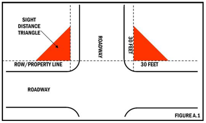
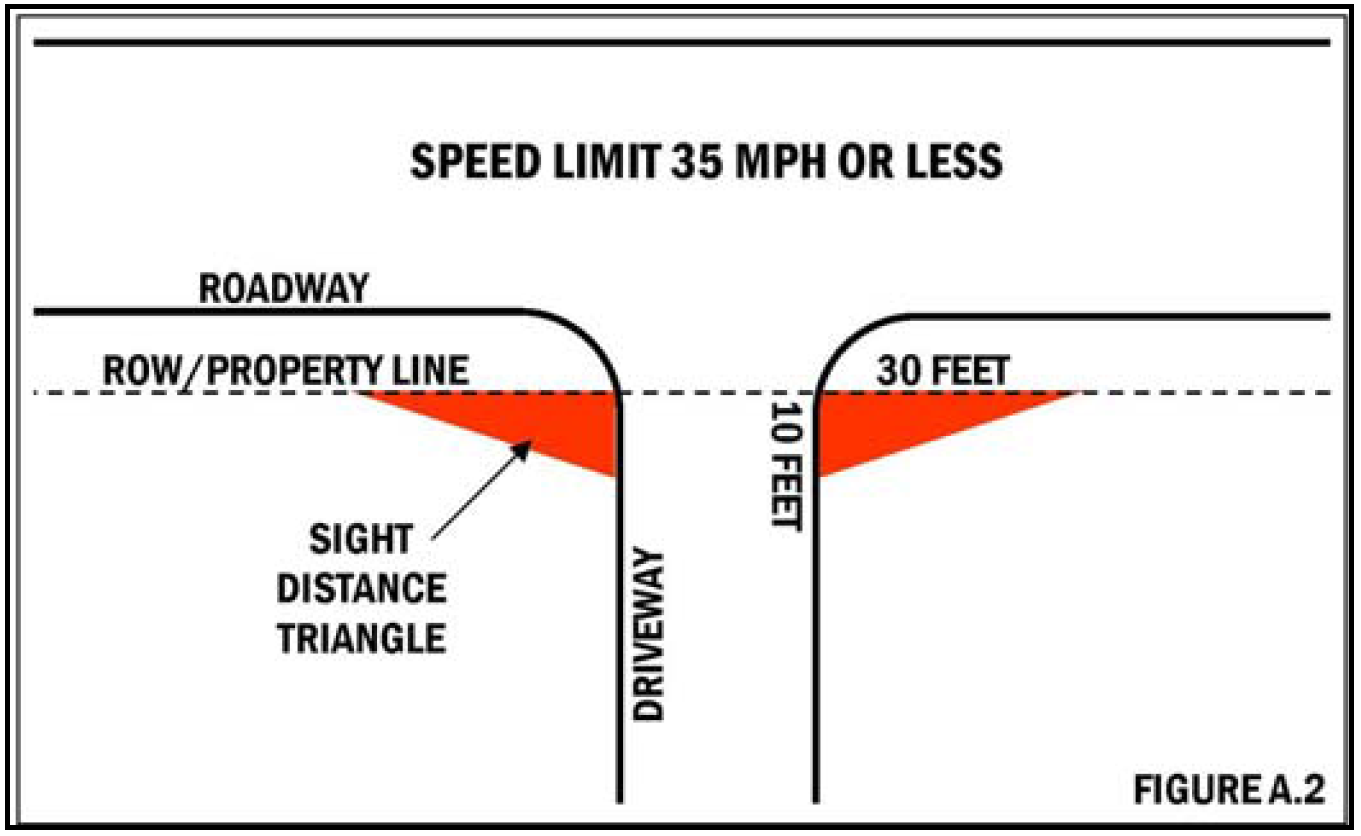
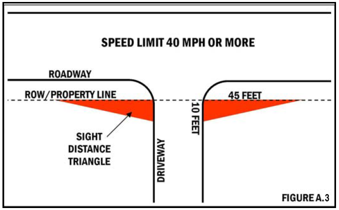
Sight distance triangle: The area of a corner lot bounded by the right-of-way lines and a line connecting the two (2) points on the property lines thirty (30) feet from the intersection of the property lines (see figure A.1). Also, the triangular area formed by a diagonal line connecting a point on a right-of-way line and a point on the curb or edge of a driveway. For a driveway accessing a street having a speed limit of thirty-five (35) miles per hour or less, sight distance triangles of ten (10) feet by thirty (30) feet are required on each side of the driveway with the longer dimension along the right-of-way (see figure A.2). For a driveway accessing a street having a speed limit of forty (40) miles per hour or more, sight distance triangles of ten (10) feet by forty-five (45) feet are required on each side of the driveway with the longer dimension along the right-of-way (see figure A.3).
Single-family detached dwelling: A detached building arranged, intended, or designed for occupancy by one (1) family with the total number of occupants limited by the International Property Maintenance Code as adopted.
Site coverage: The percentage of total site area occupied by structures (building coverage), paving for vehicle use, and all other impervious surfaces. Paving coverage includes areas necessary for the ingress, egress, outdoor parking, and circulation of motor vehicles.
Site plan: An accurately scaled drawing, or set of drawings, that illustrates all of the relevant existing conditions on a land parcel as well as depicting details of a proposed development. Specific site plan requirements are stated in section 25-4.3, site plan requirements.
Skilled nursing facilities: A residential facility licensed by the state that provides twenty-four-hour care and nursing for persons who need nursing care and medical service, but do not require intensive hospital care.
Story: That part of a building included between the surface of one floor and the surface of the floor next above, or if there be no floor above, that part of the building which is between the surface of a floor and the ceiling next above. A top story attic is a half story when the main line of the eaves is not above the middle of the interior height of such story. The first story is a half story when between fifty (50) and seventy-five (75) percent of the area of its exterior walls are exposed to outside light and air entirely above grade and which exterior walls contain windows or doors permitting the entrance of daylight and outside air.
Street: A general term denoting a public or private way which affords the principal means of vehicular access of abutting property. The term includes all facilities which normally occur within the right-of-way; it shall also include such other designations as highway, thoroughfare, parkway, throughway, road, avenue, boulevard, lane, place, court but shall not include an alley or pedestrian way.
Street, collector: Streets which move traffic from major streets, which distribute traffic regionally, to minor streets, which distribute traffic to individual lots, parcels, and uses within subdivision, area, or neighborhood. Collector streets also may serve individual lots, parcels, and uses as a secondary or additional function.
Street, cul-de-sac: A short, independent, minor street terminating in a circular turnaround.
Street, frontage or service: A minor street generally parallel to and adjacent to arterial streets and highways, which provides access to abutting properties and protection from through traffic.
Street, loop: A short, independent street which usually terminates along the same collector street of its origin.
Street, major (arterial): A street utilized for high vehicular speeds or for heavy volumes of traffic on a continuous route.
Street, minor: Streets which serve a local neighborhood and may be in the form of a cul-de-sac or loop street; provided, however, that any combination of loop and cul-de-sac streets may be utilized without the streets being designated as collector streets, provided that such an arrangement serves the same function and also that maximum fronting lots do not exceed the total which would be allowed within provisions of the street specifications matrix.
Street private: A private way which affords the principal means of vehicular access to abutting property and is owned by the abutting property owners or in common by a group of property owners.
Structure: That which is built or constructed, including without limitation because of enumeration, buildings for occupancy or use whatsoever, fences, signs, billboards, fire escapes, chute escapes, railings, water tanks, towers, open grade steps, sidewalks or stairways, tents or anything erected and framed of component parts which is fastened, anchored or rests on a permanent foundation or on the ground. For the purposes of this chapter, items such as basketball goals and uprights, bird baths, and play structures shall not be considered an accessory structure for the purpose of yard requirements.
Structures, landscaping-related: Structures of a decorative or ornamental nature which shall include arbors, benches, gazebos, pergolas, statuary, trellises, yard lighting, and landscaping timbers used to define yard areas.
Subdivision: A distinct area of land divided into lots.
Substantial construction, development or work: Except as noted elsewhere in this chapter, substantial construction, development or work shall include:
1.
Project involving structures. The completion of excavations for footings and foundations of the principal building.
2.
Project with no structures or insignificant structures. The completion of site grading.
Temporary storage unit (portable on demand storage): A transportable box-like container intended for the purpose of storing household goods and other personal property that is intended to be filled, refilled, or emptied while located outdoors on a residential property for a limited period of time.
Temporary structure: A structure without any foundation or footing that is removed when the designated time period, activity, or use for which the temporary structure was erected has ceased.
Transmit: The communication of a decision to an applicant by one of the following means:
1.
By registered mail or certified mail, in which case the communication is shall deemed transmitted as of the date shown on the United States post office records of such registration or certification and mailing; or
2.
Electronic facsimile transmission (fax), in which case the document is deemed filed at the time the applicant receives the fax, as evidenced by a printed confirmation page that displays the applicant's facsimile number and the date and time that the fax was sent, or
3.
Electronic mail (Email), in which case the document is deemed transmitted on the day that the city planner receives an electronic delivery receipt or confirmation of delivery from the applicant's electronic mail address (email address).
If the city planner does not receive confirmation by using options 2 or 3 above, the communication is not deemed transmitted unless option 1 above, is used.
Trellis: See definition in A.4, definitions relating to landscaping design.
Use: The purpose or activity for which a piece of land or its buildings is designed, arranged, or intended, or for which it is occupied or maintained.
Utility, above ground: Any pump station, utility box, or utility facility, any part of which is located above the finished ground surface.
Utility box: Any above-ground structure, cabinet, electric meter, and any other appurtenance installed for or servicing telecommunication or utility purposes above surrounding grade in the public rights-of-way. For the purpose of reviewing allowable utility boxes as part of any preliminary development plan, all structures, cabinets, electric meters, and any other appurtenance that share a common structural foundation shall be defined as one (1) utility box. All structures, cabinets, electric meters, and other appurtenances that are required to operate a facility, but that do not share a common structural foundation, are considered a separate utility box installation.
Utility facility: Any building, structure, plant, equipment or use for the provision and operation of utility services including, but not limited to water, sewage disposal, telephone service, telegraph service, communications services, telecommunications or cable television.
Variance: Relief from or variation of the provisions of these regulations, as applied to a specific piece of property, granted by the board of adjustment.
Walkway: A walkway is a path, trail, or sidewalk, designed for, and used exclusively by pedestrians.
Warehouse: A structure for use as a storage place for goods, materials, or merchandise.
Warehousing, general (storage facilities): A building used primarily for the storage of goods and materials, not produced, manufactured or assembled within that structure, and/or available to the general public for a fee.
Wholesale trade: Establishments or places of business primarily engaged in selling merchandise to retailers; to industrial, commercial, institutional, or professional business users; to other wholesales; or acting as agents or brokers and buying merchandise for, or selling merchandise to, such individuals or companies.
Yard: An open space at grade between a building and the adjoining lot lines, unoccupied and unobstructed by any portion of a structure from the ground upward, except as otherwise provided.
Yard, depth of: In measuring a yard for the purpose of determining the width of a side yard, the depth of a front yard or the depth of a rear yard, the least horizontal distance between the lot line and the building shall be used. Where lots abut a street, all yards abutting said street shall be measured from the street right-of-way.
Yard, front: A yard across the full width of the lot extending from the front line of the main building to the front line of the lot.
Yard, side: A yard between the main building and the adjacent side line of the lot, and extending entirely from a front yard to the rear yard.
Yard, rear: A yard between the rear lot line and the rear line of the main building and the side lot lines.
Zoning Code: The duly approved, enacted, and amended ordinance which controls and regulates land use in the city.
(Ord. No. 2010-3441, §§ 1, 2, 10-21-10; Ord. No. 2011-3531, § 8, 7-21-11; Ord. No. 2013-3712, § 2, 3-7-13; Ord. No. 2013-3713, § 1, 3-7-13; Ord. No. 2013-3819, § 16, 11-21-13; Ord. No. 2014-3924, § 1, 10-2-14; Ord. No. 2016-4122, § 8, 4-21-16; Ord. No. 2018-4359, § 4, 7-19-18; Ord. No. 2018-4388, § 10, 11-15-18; Ord. No. 2019-4406, § 1, 1-17-19; Ord. No. 2022-4705, §§ 1, 2, 7-21-22; Ord. No. 2023-4759, § 1, 2-16-23; Ord. No. 2023-4831, § 2, 10-19-23; Ord. No. 2023-4841, § 5, 12-7-23; Ord. No. 2024-4895, § 1, 8-1-24)
A.3. Definitions - relating to signs.
Banner: A temporary sign made of fabric, vinyl, or other light pliable material, not enclosed in a rigid frame.
Building face or wall: All window and wall areas of a building in one plane or elevation.
Copy: Any text, graphic, symbol, logo, or combination thereof intended to identify, notify, or advertise.
Electronic message center: A sign that utilizes computer generated messages or some other electronic means of changing copy. These signs include displays using incandescent lamps, LEDs, LCDs, or a flipper matrix.
Erect: To build, construct, re-construct, attach, hang, re-hang, alter, place, affix, enlarge, move or relocate and includes the painting and repainting of existing sign structures.
Flag: A piece of fabric (most often rectangular or quadrilateral) with a distinctive design that is used as a symbol, a signaling device, or a decoration, but for purposes of this sign code, does not include flags used for a commercial promotion or as an advertising device.
Logo: A letter, character, or symbol used to represent a person, corporation or business enterprise.
Premises: All contiguous lands, structures, places, used in connection with any business conducted on such site, including the interior of the establishment and the contiguous exterior walls under common ownership, control, or possession.
Property: A designated parcel, tract, or other area of land established by a plat as permitted by law and intended to be used, developed, or built upon as a unit under single ownership.
Sign: Any feature, device, structure, or fixture that incorporates graphics, symbols, written copy, or any part or combination thereof, which provides visual information, identification, direction, advertisement and/or attracts the attention of the public, which is visible from any public place or is located on private property and exposed to the public. The term "sign" shall not include the flag of any governmental unit, nor shall it include any item of merchandise normally displayed within a show window. For the purpose of removal, signs shall also include all sign structures.
Sign, abandoned: A sign which no longer correctly directs or exhorts any person, advertises a bona fide business, lessor, owner, project or activity conducted or product available on the premises where such sign is displayed.
Sign, animated: Any sign which includes action or motion. For purposes of this ordinance, this term does not refer to flashing or changing, all of which are separately defined.
Sign area, net: The area of the sign face which can be viewed at one time.
Sign area, gross: The total area of a sign (including the face and structure) which can be viewed at one time.
Sign, attached: A sign erected or placed upon the wall of any building with the plane of the face parallel to the plane of the wall below the roof line.
Sign, automated teller machine: A sign that is painted or otherwise permanently affixed to a canopy whose principal function is to provide shelter to and identification of an automated teller machine (ATM).
Sign, awning: A sign that is painted or otherwise permanently affixed to an awning.
Sign background: The portion of a sign face, on which text typically appears, which consists of a different color than the wall behind where the sign is attached or placed, the window behind or in front of the sign, or the sign structure immediately behind the text, symbol, or logo.
Sign, canopy: A sign that is painted or otherwise permanently affixed to a canopy.
Sign, changeable copy (manual): A sign on which copy is changed manually in the field, i.e., reader boards with changeable letters or changeable pictorial panels.
Sign, changing (automatic): A sign such as an electronically or electrically controlled public service time, temperature and date sign, message center or reader board, where different copy changes are shown on the same lamp bank.
Sign, double-faced: A sign which has two sides, parallel to each other, facing in exact opposite directions.
Sign face: The part of the sign that displays the message, including the sign copy and sign background.
Sign, flashing: Any sign which contains an intermittent or flashing light source, or which includes the illusion of intermittent or flashing light by means of animation, or an externally mounted intermittent light source. Automatic changing signs such as public service time, temperature and date signs or electronically controlled message centers are not defined as "flashing signs."
Sign, fluttering: A sign which flutters and includes banners, flags, pennants, or other flexible material which moves with the wind or by some artificial means.
Sign frame: The part of the sign surrounding the sign face but excluding the base, supports, uprights, or bracing.
Sign, freestanding: A sign anchored to the ground by a base, pole, or other supports which is not attached to or dependent on support from any building.
Sign, government: A sign erected, owned, leased, or maintained by any city or county, the state, or federal government for the purpose of discharging any government function.
Sign height: The vertical distance measured from the surrounding grade to the highest point of a sign.
Sign, illegal: A sign which contravenes this ordinance, or a nonconforming sign for which a permit required under a previous ordinance was not obtained.
Sign, illuminated: Any sign which is illuminated by light source mounted on or in the sign or at some other location.
Sign, neon: A sign utilizing neon tubing formed into letters, shapes, or images.
Sign, nonconforming: A sign legally erected prior to this ordinance, but which does not conform to the provisions of this Code.
Sign, obscene: A sign of any description or presentation, in whatever form. When it predominately appeals to the prurient, shameful, or morbid interests of minors in sex; is patently offensive to contemporary standards in the adult community as a whole with respect to what is suitable sexual material for minors; and taken as a whole, lacks serious literary, artistic, political, or scientific value.
Sign, off-premises: A sign relating its subject matter to premises other than the premises on which it is located or to products, accommodations, services, or activities available on premises other than the premises on which the sign is located.
Sign, outline lighting: A form of sign utilizing neon tubing, fluorescent tubes or other illuminating device around the perimeter of a sign, window, door, building or other architectural element or portions thereof. Such signs may or may not include any text or images.
Sign, permanent: A sign permanently affixed to a building or structure or to the ground.
Sign, political: A sign with a message in support of or in opposition to a person seeking elected office or a ballot measure, as further defined by the Missouri Revised Statutes.
Sign, portable: A sign which has a supporting structure intended, by design and construction, to rest upon the ground for support and may be easily moved or relocated for reuse, e.g., A-frame or sandwich board signs.
Sign, real estate: A sign pertaining only to the prospective rental, lease, or sale of the property upon which it is located, as further defined by the Missouri Revised Statutes.
Sign structure: The base, supports, uprights, bracing, or framework of or around a sign.
Sign supports: All structures by which a sign is held up, including, for example, poles, braces, guys, and anchors.
Sign, temporary: Any sign intended for a limited or intermittent period of display, such as real estate signs, political signs, or signs displayed during special events. Temporary signs are those signs that are not intended or not constructed for permanent placement pursuant to the requirements of the sign regulations, as well as the city's building and property maintenance codes. Holiday or seasonal decorations shall not be considered temporary signs.
Sign, vehicle: Any lettering or graphic depiction painted on, magnetically attached to, or otherwise visible on or in a vehicle of any nature.
Sign, window: A temporary or permanent sign affixed to the interior or exterior of a window, placed immediately behind or within three (3) feet of a window pane. For the purposes of this ordinance, glass doors are considered windows.
Sign, yard: A temporary sign constructed of corrugated plastic or similar material mounted to a metal post placed in the ground.
Standard outdoor advertising structure and/or billboard: Any sign intended to attract general public interest concerning a commercial enterprise, product, service, industry, or other activity not conducted, sold or offered on the premises upon which the sign is erected. This includes billboards, detached pole signs on separate parcels, wall signs and signs otherwise attached to buildings and/or supported by uprights on braces on the ground. Real estate signs and political signs are excluded from this definition.
Surrounding grade: For the purposes of sign regulation, the mean average grade as measured at the base of the sign.
(Ord. No. 2013-3792, §§ 1, 2, 9-5-13; Ord. No. 2016-4140, § 1, 6-2-16; Ord. No. 2019-4402, § 2, 1-17-19)
A.4. - Definitions relating to landscaping design.
Arbor: An open freestanding structure which serves as an entranceway to a yard or garden, on which climbing plants are typically trained to grow.
Berm: A mound of soil, either natural or man made, used to screen and visually separate in part or entirely, one area, site or property from the view of another area.
Building development area: The limit of construction activity around structures as measured fifteen (15) feet from the exterior edge of the footing of a non-residential structure and ten (10) feet from the exterior edge of the footing of a residential structure.
Caliper: Caliper of the trunk shall be taken six (6) inches above the ground for and up to and including four-inch caliper size, and twelve (12) inches above the ground for larger sizes.
Clearing: Includes, but is not limited to, the removal of trees, understory shrubbery, bush, ground cover and or topsoil from any part of the land but does not include maintenance mowing.
Critical root zone (CRZ): A circular region measured outward from a tree trunk representing the essential area of the roots that must be maintained or protected for the tree's survival. For the purposes of this chapter, the critical root zone shall be considered as one (1) foot of radial distance for every inch of the DBH, with a minimum of eight (8) feet.
Diameter-at-breast height (DBH): Diameter-at-breast-height is tree trunk diameter measured in inches at the height of four and one-half (4.5) feet above ground.
Disturbance: Related to tree preservation, disturbance is the intentional or unintentional removal, destruction, or killing of any tree or causing the loss of more than twenty (20) percent of the tree canopy coverage or critical root zone of such tree.
Drip line (DL): The area under a tree, which is defined as a vertical line extending from the edge of the tree's outer most branches to the ground.
Gazebo: An ornamental structure, with a covered roof and five (5) or more sides (all of which are open), constructed of wood, metal, or vinyl.
Groundcover: Low growing plants are defined as plants that cover the ground, used instead of turf. Plants that do not exceed eighteen (18) inches in height are classified as groundcover.
Height, planting material: Height shall be defined as the measurement taken from grade to the average uppermost point of growth of the plant. Sizes shall be listed in one-foot increments to eight (8) feet and two-foot increments thereafter. Shrub heights shall be given in one-foot increments. On shrubs with spreading habits, the size given shall refer to the spread of the plant and not the height.
Pergola: An open freestanding or attached structure comprised of columns supporting a roof of trelliswork on which climbing plants are typically trained to grow.
Site development area: The limit of construction activity as measured two (2) feet from the edge of a residential or commercial driveway, parking lot or loading/unloading area, or street.
Stormwater management area: Any area required by the city or MSD to retain, detain, store or convey stormwater runoff so that flooding is mitigated.
Street tree: Any tree planted within the public right-of-way, or directly adjacent to public and/or private driveways where the public will encounter the plant material.
Tree, canopy/overstory: A single stem tree that has a roof-like mass of shading limbs and foliage. At maturity, such tree is typically taller than fifty (50) feet in height.
Tree, evergreen: A tree that retains its foliage year round.
Tree, ornamental/understory: A single or multiple stem tree that is smaller by nature than a canopy tree and usually has an interesting flower or other characteristic. At maturity, such tree is typically less than thirty-five (35) feet in height.
Tree preservation area: This area shall apply to residential development only. It shall be a minimum of fifteen (15) feet as measured from the exterior property line of the development, encompassing the entire property.
Trellis: A frame of small boards (lattice) designed to train or support plants.
(Ord. No. 2013-3819, § 17, 11-21-13; Ord. No. 2023-4841, § 5, 12-7-23)
A.5. - Definitions relating to lighting.
Direct light: Light emitted directly from the lamp, off of the reflector or reflector diffuser, or through the refractor or diffuser lens, of a luminaire.
Fixture: The assembly that holds a lamp and may include an assembly housing, a mounting bracket or pole socket, a lamp holder, a ballast, a reflector or mirror, and a refractor or lens.
Fluorescent lamp or tube: Electric-discharge lighting utilizing glass tubing manufactured to standard lengths.
Footcandle: A unit of illumination produced on a surface, all points of which are one-foot from a uniform point source of one candle.
Glare: Direct light emitted by a luminaire that causes reduced vision or momentary blindness.
Illuminance: The level of light measured at a surface.
Lamp: The component of a luminaire that produces the light.
Light-emitting diode (LED): A p-n junction solid-state diode whose radiated output is a function of its physical construction, material used, and exciting current. The output can be in the infrared or in the visible region.
Light pollution: General sky glow caused by the scattering of artificial light in the atmosphere, much of which is caused by poorly-designed luminaires.
Light shield: Any attachment which interrupts and blocks the path of light emitted from a luminaire or fixture.
Light trespass: Light emitted by a luminaire that shines beyond the boundaries of the property on which the luminaire is located.
Lumen: A unit of measure of luminous flux.
Luminaire: The complete lighting system, including the lamp and the fixture.
Luminaire full cutoff: A luminaire that allows no direct light emissions above a horizontal plane through the luminaire's lowest light-emitting part.
Neon tubing: Electric discharge, cold cathode tubing manufactured into shapes that form letters, parts of letters, skeleton tubing, outline lighting, and other decorative elements or art forms, in various colors and diameters and filled with inert gases.
Outdoor light fixture: Outdoor artificial illuminating devices, installed or portable, used for floodlighting, general illumination, or advertisement.
Shielded: A light fixture whose output is controlled in such a manner that a direct view of the light emitting surface from an adjacent property is either minimized or prevented. This control could be as a result of the fixture housing, external or internal control devices (louvers, shields, barn doors, etc.), placement of the luminaire on the subject property, or any combination of these elements. Shielding may either be full or partial.
Shielded-fully: Outdoor light fixtures shielded or constructed so that no light rays are emitted by the installed fixture at angles above the horizontal plane passing through the lowest point of the fixture from which the light is emitted as certified by a photometric test report.
Shielded-partially: Outdoor light fixtures shielded or constructed so that the lower edge of the shield is at or below the centerline of the light source or lamp so as to minimize light emissions above the horizontal plane.
Temporary outdoor lighting: The specific illumination of an outside area of object by any manmade device located outdoors that produces light by any means for a period of no more than thirty (30) days, with at least one hundred eighty (180) days passing before being used again.
A.6. - Definitions relating to wireless communications.[8]
In accordance with RSMo 67.5090 to 67.5125, or other applicable state law, as the same may be amended or supplemented, the following terms shall mean:
Accessory equipment: any equipment serving or being used in conjunction with a wireless communications facility or wireless support structure. The term includes utility or transmission equipment, power supplies, generators, batteries, cables, equipment buildings, cabinets and storage sheds, shelters, or similar structures.
Antenna: communications equipment that transmits or receives electromagnetic radio signals used in the provision of any type of wireless communications services.
Applicable codes: uniform building, fire, electrical, plumbing, or mechanical codes adopted by a recognized national code organization or local amendments to such codes enacted to prevent physical property damage or reasonably foreseeable injury to persons to the extent not inconsistent with RSMo 67.5110 to 67.5121.
Applicant: any person engaged in the business of providing wireless communications services or the wireless communications infrastructure required for wireless communications services who submits an application.
Application: a request submitted by an applicant to an authority to construct a new wireless support structure, for the substantial modification of a wireless support structure, for co-location of a wireless facility or replacement of a wireless facility on an existing structure, for co-location of small wireless facilities on a utility pole or wireless support structure, or to approve the installation, modification, or replacement of a utility pole.
Authority: each state, county, and municipal governing body, board, agency, office, or commission authorized by law and acting in its capacity to make legislative, quasi-judicial, or administrative decisions relative to zoning or building permit review of an application. The term shall not include state courts having jurisdiction over land use, planning, or zoning decisions made by an authority. Additionally, the term shall not include municipal electric utilities or state courts having jurisdiction over an authority.
Authority pole: a utility pole owned, managed, or operated by or on behalf of an authority, but such term shall not include municipal electric utility distribution poles or facilities.
Authority wireless support structure: a wireless support structure owned, managed, or operated by or on behalf of an authority.
Base station: a station at a specific site authorized to communicate with mobile stations, generally consisting of radio transceivers, antennas, coaxial cables, power supplies, and other associated electronics, and includes a structure that currently supports or houses an antenna, a transceiver, coaxial cables, power supplies, or other associated equipment.
Building permit: a permit issued by an authority prior to commencement of work on the co-location of wireless facilities on an existing structure, the substantial modification of a wireless support structure, or the commencement of construction of any new wireless support structure, solely to ensure that the work to be performed by the applicant satisfies the applicable building code.
Co-location: the placement or installation of a new wireless facility on a structure that already has an existing wireless facility, including electrical transmission towers, water towers, buildings, and other structures capable of structurally supporting the attachment of wireless facilities in compliance with applicable codes. For deployment of small cell facilities, co-location shall mean to install, mount, maintain, modify, operate, or replace small wireless facilities on or immediately adjacent to a wireless support structure or utility pole, provided that the small wireless facility antenna is located on the wireless support structure or utility pole.
Communications facility: the set of equipment and network components, including wires, cables, and associated facilities used by a cable operator, as defined in 47 U.S.C. Section 522(5); a telecommunications carrier, as defined in 47 U.S.C. Section 153(51); a provider of information service, as defined in 47 U.S.C. Section 153(24); or a wireless services provider; to provide communications services, including cable service, as defined in 47 U.S.C. Section 522(6); telecommunications service, as defined in 47 U.S.C. Section 153(53); an information service, as defined in 47 U.S.C. Section 153(24); wireless communications service; or other one-way or two-way communications service.
Communications service provider: a cable operator, as defined in 47 U.S.C. Section 522(5); a provider of information service, as defined in 47 U.S.C. Section 153(24); a telecommunications carrier, as defined in 47 U.S.C. Section 153(51); or a wireless provider.
Decorative pole: an authority pole that is specially designed and placed for aesthetic purposes.
Electrical transmission tower: an electrical transmission structure used to support high voltage overhead power lines. The term shall not include any utility pole.
Equipment compound: an area surrounding or near a wireless support structure within which are located wireless facilities.
Existing structure: a structure that exists at the time a request to place wireless facilities on a structure is filed with an authority. The term includes any structure that is capable of supporting the attachment of wireless facilities in compliance with applicable building codes, National Electric Safety Codes, and recognized industry standards for structural safety, capacity, reliability, and engineering, including, but not limited to, towers, buildings, and water towers. The term shall not include any utility pole.
Fee: a one-time, nonrecurring charge.
Historic district: a group of buildings, properties, or sites that are either listed in the National Register of Historic Places or formally determined eligible for listing by the Keeper of the National Register, the individual who has been delegated the authority by the federal agency to list properties and determine their eligibility for the National Register, in accordance with Section VI.D.1.a.i-v of the Nationwide Programmatic Agreement codified at 47 C.F.R. Part 1, Appendix C, or are otherwise located in a district made subject to special design standards adopted by a local ordinance or under state law as of January 1, 2018, or subsequently enacted for new developments.
Micro wireless facility: a small wireless facility that meets the following qualifications:
A.
Is not larger in dimension than twenty-four (24) inches in length, fifteen (15) inches in width, and twelve (12) inches in height; and
B.
Any exterior antenna no longer than eleven (11) inches.
Permit: a written authorization required by an authority to perform an action or initiate, continue, or complete a project.
Person: an individual, corporation, limited liability company, partnership, association, trust, or other entity or organization, including an authority.
Rate: a recurring charge.
Replacement: includes constructing a new wireless support structure of equal proportions and of equal height or such other height that would not constitute a substantial modification to an existing structure in order to support wireless facilities or to accommodate co-location and includes the associated removal of the preexisting wireless facilities or wireless support structure.
Right-of-way: the area on, below, or above a public roadway, highway, street, sidewalk, alley, or similar property used for public travel, but not including a federal interstate highway, railroad right-of-way, or private easement.
Small wireless facility: a wireless facility that meets both of the following qualifications:
A.
Each wireless provider's antenna could fit within an enclosure of no more than six (6) cubic feet in volume; and
B.
All other equipment associated with the wireless facility, whether ground or pole mounted, is cumulatively no more than twenty-eight (28) cubic feet in volume, provided that no single piece of equipment on the utility pole shall exceed nine (9) cubic feet in volume; and no single piece of ground-mounted equipment shall exceed fifteen (15) cubic feet in volume, exclusive of equipment required by an electric utility or municipal electric utility to power the small wireless facility.
C.
The following types of associated ancillary equipment shall not be included in the calculation of equipment volume: electric meter, concealment elements, telecommunications demarcation box, grounding equipment, power transfer switch, cut-off switch, and vertical cable runs and related conduit for the connection of power and other services.
Substantial modification: the mounting of a proposed wireless facility on a wireless support structure which, as applied to the structure as it was originally constructed:
A.
Increases the existing vertical height of the structure by:
1.
More than ten (10) percent; or
2.
The height of one (1) additional antenna array with separation from the nearest existing antenna not to exceed twenty (20) feet, whichever is greater; or
b.
Involves adding an appurtenance to the body of a wireless support structure that protrudes horizontally from the edge of the wireless support structure more than twenty (20) feet or more than the width of the wireless support structure at the level of the appurtenance, whichever is greater (except where necessary to shelter the antenna from inclement weather or to connect the antenna to the tower via cable);
c.
Involves the installation of more than the standard number of new outdoor equipment cabinets for the technology involved, not to exceed four (4) new equipment cabinets; or
d.
Increases the square footage of the existing equipment compound by more than one thousand two hundred fifty (1,250) square feet.
Technically feasible: by virtue of engineering or spectrum usage, the proposed placement for a small wireless facility or its design or site location can be implemented without a reduction in the functionality of the small wireless facility.
Utility: any person, corporation, county, municipality acting in its capacity as a utility, municipal utility board, or other entity, or department thereof or entity related thereto, providing retail or wholesale electric, natural gas, water, waste water, data, cable television, or telecommunications or internet protocol-related services.
Utility pole: a pole or similar structure that is or may be used in whole or in part by or for wireline communications, electric distribution, lighting, traffic control, signage, or a similar function, or for the co-location of small wireless facilities; provided, however, such term shall not include wireless support structures, electric transmission structures, or breakaway poles owned by the state highways and transportation commission.
Water tower: a water storage tank, or a standpipe or an elevated tank situated on a support structure, originally constructed for use as a reservoir or facility to store or deliver water.
Wireless communications service: includes the wireless facilities of all services licensed to use radio communications pursuant to Section 301 of the Communications Act of 1934, 47 U.S.C. Section 301.
Wireless facility: equipment at a fixed location that enables wireless communications between user equipment and a communications network, including equipment associated with wireless communications and radio transceivers, antennas, coaxial or fiber-optic cable, regular and backup power supplies, and comparable equipment, regardless of technological configuration. The term includes small wireless facilities. The term does not include:
A.
The structure or improvements on, under, or within which the equipment is co-located;
B.
Coaxial or fiber-optic cable between wireless support structures or utility poles;
C.
Coaxial or fiber-optic cable not directly associated with a particular small wireless facility; or
D.
A wireline backhaul facility.
Wireless infrastructure provider: any person, including a person authorized to provide telecommunications service in the state, that builds or installs wireless communication transmission equipment or wireless facilities but that is not a wireless services provider.
Wireless provider: a wireless infrastructure provider or a wireless services provider.
Wireless services: any services using licensed or unlicensed spectrum, including the use of Wi-Fi, whether at a fixed location or mobile, provided to the public using wireless facilities.
Wireless services provider: a person who provides wireless services.
Wireless support structure: an existing structure, such as a monopole or tower, whether guyed or self-supporting, designed to support or capable of supporting wireless facilities; an existing or proposed billboard; an existing or proposed building; or other existing or proposed structure capable of supporting wireless facilities, other than a structure designed solely for the co-location of small wireless facilities. Such term shall not include a utility pole.
Wireline backhaul facility: a physical transmission path, all or part of which is within the right-of-way, used for the transport of communication data by wire from a wireless facility to a network.
(Ord. No. 2020-4539, § 2, 9-3-2020)
Editor's note— Ord. No. 2020-4539, § 2, adopted Sept. 3, 2020, repealed the former App. 6, and enacted a new App. 6 as set out herein. The former App. 6 pertained to similar subject matter.
A.7. - Definitions relating to air navigation.
Airplane design group: A grouping of airplanes based on wingspan. The groups are as follows in Table A.7.1.
Airport boundaries: All real property in which an airport has acquired an easement, leasehold or fee interest.
Airport: An area of land or water that is used or intended to be used for the landing and takeoff of aircraft, and includes its buildings and facilities, if any.
Airport approach category: A grouping of aircraft based on one and three-tenths (1.3) times their stall speed in their landing configuration at their maximum certificated landing weight. The categories are as follows in table A.7.2.
Airport boundaries: All real property in which an airport has acquired an easement, leasehold or fee interest.
Airport elevation: The highest point of an airport's usable landing area measured in feet from sea level.
Approach surface: A surface longitudinally centered on the extended runway centerline, extending outward and upward from the end of the primary surface and at the same slope as the approach zone height limitation slope. In plan the perimeter of the approach surface coincides with the perimeter of the approach zone.
Conical surface: A surface extending outward and upward from the periphery of the horizontal surface at a slope of twenty to one (20:1) for a horizontal distance of four thousand (4,000) feet.
Displaced threshold: The portion of pavement behind a displaced threshold may be available for takeoffs in either direction and landings from the opposite direction.
Hazard to air navigation: An obstruction determined to have a substantial adverse effect on the safe and efficient utilization of the navigable airspace.
Height: For the purpose of determining the height limits in all zones set forth in the ordinance and shown on the zoning map, the datum shall be mean sea level elevation unless otherwise specified.
Horizontal surface: A horizontal plane one hundred fifty (150) feet above the established airport elevation, the perimeter of which in plan coincides with the perimeter of the horizontal zone.
Object: A structure, including a mobile structure, constructed or installed by man, or a product of nature, including but without limitation: buildings, towers, cranes, smokestacks, earth formations, trees, overhead transmission lines, and utility poles.
Person: An individual, firm, partnership, corporation, company, association, joint stock association, or governmental entity; includes a trustee, a receiver, an assignee, or similar representative of any of them.
Primary surface: A surface longitudinally centered on a runway. When the runway has a specially prepared hard surface, the primary surface extends two hundred (200) feet beyond each end of that runway; when the runway has no specially prepared hard surface, or planned hard surface, the primary surface ends at each end of that runway.
Relocated threshold: The portion of pavement behind a relocated threshold is not available for takeoff or landing. It may be available for taxiing of aircraft.
Runway: A defined area on an airport prepared for landing and takeoff of aircraft along its length.
Runway protection zone: The RPZ is trapezoidal in shape and centered about the extended runway centerline. It begins two hundred (200) feet beyond the end of the area usable for takeoff or landing. The definition herein is intended to and will be consistent with the definition as given in Advisory Circular 150/5300-13, dated September 29, 1989, or the most recent definition as provided by the Federal Aviation Administration.
Threshold: The beginning of that portion of the runway available for landing. When the threshold is located at a point other than at the beginning of the pavement, it is referred to as either a displaced threshold or a relocated threshold depending on how the pavement behind the threshold may be used.
Transitional surfaces: Those surfaces extending outward at ninety (90) degree angles to the runway centerline and the runway centerline extended at a slope of seven (7) feet horizontally for each foot vertically from the sides of the primary and approach surfaces to where they intersect the horizontal and conical surfaces. Transitional surfaces for those portions of the precision approach surfaces, which project through and beyond the limits of the conical surface, extending a distance of five thousand (5,000) feet measured horizontally from the edge of the approach surface and at ninety (90) degree angles to the extended runway centerline.
Tree: Any object of natural growth.
Utility runway: A runway that is constructed for and intended to be used by propeller driven aircraft of twelve thousand five hundred (12,500) pounds maximum gross weight and less.
Visual runway: A runway intended solely for the operation of aircraft using visual approach procedures.
A.8. - Definitions relating to excursion gaming.
Dock: The location where an excursion gambling boat is continuously docked or where an excursion gambling boat moors for the purpose of embarking passengers for and disembarking passengers from a gambling excursion.
Excursion gambling boat or floating facility: A boat, vessel, ferry, or other floating facility built or originally built as a boat, ferry or barge licensed by the Missouri Gaming Commission on which gambling games are allowed.
(Ord. No. 2008-3179, § 1, 12-18-08)