
Mesa City Zoning Code
ARTICLE 1
INTRODUCTORY PROVISIONS
CHAPTER 1 - INTRODUCTORY PROVISIONS[2]
Editor's note— Previously, Chapter 1 derived from Ord. No. 4842, 5-19-08; Ord. No. 4843, 5-19-08; Ord. No. 4913, 2-17-09; Ord. No. 5025, 2-7-11.
CHAPTER 2 - RULES FOR THE CONSTRUCTION OF LANGUAGE AND INTERPRETATION[3]
Editor's note— Previously, Chapter 2 derived from Ord. No. 5032, 3-21-11; Ord. No. 5123, 9-24-12; Ord. No. 5447, 7-9-18.
CHAPTER 3 - DESIGNATION OF ZONING DISTRICTS, ZONING MAP, AND BOUNDARIES[4]
Editor's note— Previously, Chapter 3 derived from Ord. No. 3746, 2-22-00; Ord. No. 4262, 8-16-04.
11-1-1: - TITLE AND AUTHORITY
Title 11 of the City Code shall be known and cited as the "City of Mesa Zoning Ordinance," "Zoning Ordinance of the City of Mesa," "Zoning Ordinance", or "this Ordinance". Whenever reference is made to any portion of the ordinance set out in this Title 11, or of any other law or ordinance, the reference applies to all amendments and additions to this Title made hereafter.
(Ord. No. 3746, 2-22-00)
11-1-2: - PURPOSE
The purpose of this Ordinance is to implement the City's General Plan and to protect and promote the public health, safety, peace, comfort, convenience, prosperity and general welfare. More specifically, this Ordinance is intended to:
A.
Provide a guide for the physical development of the City in a manner that progressively achieves the arrangement of land uses depicted in the General Plan, consistent with the goals and policies of the General Plan.
B.
Promote combinations and mixtures of harmonious land uses, limit the effects of incompatible land uses, and do so in a manner that reduces transportation requirements, promotes livability, and raises the quality of life for residents, guests, students, workers, business owners, tourists and other visitors.
C.
Foster a harmonious, convenient and workable relationship among land uses and ensure compatible infill development, consistent with the General Plan.
D.
Support economic development and job creation.
E.
Provide for the diverse housing needs of all economic segments of the community.
F.
Promote high quality architecture and design.
G.
Promote the stability of existing land uses that conform to the General Plan, protecting them from inharmonious influences and harmful intrusions.
H.
Promote a safe and efficient traffic circulation system; foster the provision of adequate off-street parking and off-street loading facilities, bicycle facilities and pedestrian amenities, and support a multi-modal transportation system. Encourage improved connectivity between residential, commercial, educational, employment and recreational uses.
I.
Facilitate the appropriate location of community facilities, institutions and parks and recreational areas.
J.
Protect and enhance real property values.
K.
Promote environmental quality and encourage development patterns that meet the following sustainability goals: improve air quality; improve energy conservation and renewable energy production; integrate land use and mobility; allow housing diversity; improve community health and safety; increase water conservation; and mitigate stormwater pollution.
L.
Provide diverse settings, with a wide-range of employment, housing and commercial options and a variety of intensities of land uses.
M.
Provide development options that are designed in an aesthetically pleasing manner, incorporate public spaces in manners that are integral to projects, and provide effective transitions between abutting parcels appropriate to the context of the circumstance.
N.
Safeguard and enhance the appearance of the City.
O.
Define duties and powers of administrative bodies and officers responsible for implementation of this Ordinance.
11-1-3: - STRUCTURE OF ZONING REGULATIONS
A.
Organization of Regulations. This Ordinance consists of eight articles:
Article 1: Introductory Provisions
Article 2: Base Zones
Article 3: Overlay Zones
Article 4: Development Regulations
Article 5: Sign Regulations
Article 6: Form-Based Development Regulations
Article 7: Administration and Permits
Article 8: General Terms
B.
Types of Regulations. Four types of zoning regulations control the use and development of property in the City:
1.
Land Use Regulations. These regulations specify land uses permitted, conditionally permitted or specifically prohibited in each zone, and include special requirements, if any, applicable to specific uses. Land use regulations for base zones are in Article 2 of this Ordinance and in Article 3 for overlay zone regulations. Certain regulations, applicable in some or all of the districts, and performance standards that govern special uses, are in Article 4. When used in conjunction with an adopted regulating plan, use standards related to specific building forms located within specified transects are found in Article 6.
2.
Development Regulations. These regulations control the height, bulk, density, intensity, location and appearance of structures on development sites. Development regulations for base zones are in Article 2 of this Ordinance. The regulations for overlay zones are in Article 3. Certain development regulations, applicable to some or all zones are in Article 4. These include regulations for specific uses, development and site regulations, performance standards, parking, sign, antennas and wireless telecommunications and nonconforming uses. Sign regulations are found in Article 5. Certain other development regulations principally oriented on building form and building placement (also known as Form-Based Code) are found in Article 6.
3.
Administrative Regulations. These regulations contain detailed procedures for the administration of this Ordinance, and include responsibilities of the planning agency, common procedures, processes and standards for discretionary entitlement applications and other permits. Administrative regulations are found in Article 7.
4.
General Terms and Use Classifications.Article 8 provides a list of use classifications and a list of terms and definitions used in this Ordinance.
(Ord. No. 4006, 8-5-02)
11-1-4: - GENERAL RULES FOR APPLICABILITY OF ZONING REGULATIONS
A.
Applicability to Property. This Ordinance shall apply, to the extent permitted by law, to all property within the City of Mesa, including all uses, structures and land owned by any private person, firm, corporation or organization, or local, state or federal agencies. Any governmental agency shall be exempt from the provisions of this Ordinance only to the extent that such property may not be lawfully regulated by the City of Mesa.
B.
Compliance with Regulations. No land shall be used, and no structure shall be constructed, occupied, enlarged, altered, demolished or moved in any zoning district, except in accordance with the provisions of this Ordinance.
C.
Provisions Interpreted as Minimum Requirements. In interpreting and applying the provisions of Title 11, the applicant shall meet or exceed the minimum requirements for the promotion of the public health, safety, comfort, convenience and general welfare.
D.
Relation to Other Regulations. The regulations of this Ordinance and requirements or conditions imposed pursuant to this Ordinance shall not supersede any other regulations or requirements adopted or imposed by the State of Arizona, or any federal agency that has jurisdiction by law over uses and development authorized by this Ordinance. All uses and development authorized by this Ordinance shall comply with all other such regulations and requirements. Where conflict occurs between the provisions of the Ordinance and any other City Ordinance, chapter, resolution, guideline or regulation, the more restrictive provisions shall control, unless otherwise specified.
E.
Relation to Private Agreements. The provisions of this Ordinance shall apply regardless of any private agreements in the event that the provisions of this Ordinance are more restrictive. Otherwise, this Ordinance shall not interfere with, affect or annul any recorded easement, covenant, or other private agreement now in effect, unless a Development Agreement has been authorized by the City Council and executed by recording the Development Agreement with the County Recorder's Office, pursuant to ARS 9-500.05.
11-1-5: - CONSISTENCY WITH THE GENERAL PLAN
Each application for Special Use Permits, Council Use Permits, site plan review, site plan modification or request to modify the zoning classification of a parcel of land shall be reviewed and evaluated for consistency with the City of Mesa General Plan. With regard to requests to modify the zoning classification of specific parcels of land, where there is a conflict between this Ordinance and the General Plan, the General Plan shall prevail.
(Ord. No. 3943, 11-5-01)
11-1-6: - EFFECT ON PREVIOUSLY APPROVED PROJECTS AND PROJECTS IN PROGRESS
Upon the effective date of this Ordinance, the following requirements shall apply to all properties:
A.
Violations Continue. Any violation of the Zoning Ordinance previously in effect will continue to be a violation under this Ordinance and shall be subject to penalties and enforcement under Title 11, Chapter 79 unless the use, development, construction or other activity complies with the provisions of this Ordinance.
B.
Projects with Approvals or Permits.
1.
Design Review Approved Prior to Effective Date of this Ordinance. A project which has received Design Review approval prior to the effective date of the this Ordinance may file an application for a building permit in compliance with the approved Design Review plan and conditions of approval, even if the project does not comply with the provisions of the this Ordinance. Upon approval of the construction plans, a building permit may be issued. The Design Review approval for projects approved prior to the effective date of this Ordinance shall be valid for 3 years from the effective date of approval of this Ordinance. No time extensions shall be permitted.
2.
Preliminary Subdivision Plat Approved Prior to Effective Date of the This Ordinance. A project which has a preliminary plat approved prior to the effective date of the this Ordinance may file an application for a final subdivision plat and improvement plan approval, even if the subdivision does not fully comply with the provisions of the this Ordinance. If a final plat application is not filed within 1 year, unless extended as provided by the Subdivision Regulations, of the date of preliminary plat approval, the preliminary plat shall expire. No time extensions shall be permitted. Subsequent preliminary plat applications shall comply with this Ordinance.
3.
Conditional Use Permit Approved Prior to Effective Date of this Ordinance, No Design Review Required. A project which has received a conditional use permit (including Special Use Permits or Council Use Permits prior to the effective date of this Ordinance may file an application for a building permit, even if the project does not fully comply with the provisions of the this Ordinance. If a building permit application is not filed within 1 year of the date of the conditional use permit approval, the use permit shall expire. No time extensions shall be permitted.
4.
Conditional Use Permit Approved Prior to Effective Date of this Ordinance, Design Review Required. A project which has an approved conditional use permit (including Special Use Permits or Council Use Permits may file an application for Design Review even if the use does not fully comply with the provisions of the this Ordinance. If a Design Review application is not filed within 1 year of the date of the conditional use permit approval, the conditional use permit shall expire. If an application is made for design review approval within 1 year and that approval is received, the conditional use permit shall remain valid for a period of 1 more year provided a building permit is applied for and construction commences within that year. No time extensions shall be permitted. Subsequent applications for design review shall comply with this Ordinance.
5.
Building Permit Application Filed Prior to Effective Date of this Ordinance. Any building, structure, or sign for which a completed building permit application is filed prior to the effective date of the this Ordinance may be issued a building permit and may be constructed in compliance with the building permit and other applicable approvals, permits and conditions, even if such building, structure or sign does not fully comply with the this Ordinance. If construction has not commenced in compliance with the applicable permit terms, the Building Official may grant an extension pursuant to the provisions of the building code. If the building, structure, or sign has not been completed before the building permit or any extension of the permit expires, then the building, structure, or sign shall be constructed, completed or occupied only in compliance with the this Ordinance.
6.
Building Permit Issued Prior to Effective Date of this Ordinance. Any building, structure, or sign for which a lawful building permit is issued prior to the effective date of this Ordinance may be completed in conformance with the permit and other applicable permits and conditions, even if such building, structure or sign does not fully comply with this Ordinance. If construction has not commenced in compliance with the applicable permit terms, the Building Official may grant an extension pursuant to the provisions of the building code. If the building, structure, or sign has not been completed in conformance with the building permit and any extension thereof, then the building, structure, or sign shall be constructed, completed or occupied only in compliance with this Ordinance.
C.
Planning Applications Filed Prior to the Effective Date of this Ordinance.
1.
Applications for Design Review, Site Plan Review and Preliminary Plats, or Modifications to Previously Approved Applications, Submitted Prior to the Effective Date of this Ordinance. Complete applications filed prior to the effective date of this Ordinance may be approved under the provisions of the Zoning Ordinance in place prior to the effective date of this Ordinance. Applicants may elect to develop under the provisions of this Ordinance, but in that case shall comply with all provisions of this Ordinance. If a building permit application is not filed within 3 years of the date of approval of the Design Review, or 1-year after the approval of the preliminary plat, the approval shall expire. No time extensions shall be permitted, unless approval of the preliminary plat is extended, based on the requirements of the Subdivision Regulations (Title 9, Chapter 6 of the Mesa City Code).
2.
Applications for Conditional Use Permit Submitted Prior to the Effective Date of this Ordinance. Complete applications filed prior to the effective date of this Ordinance may be approved under the provisions of the Zoning Ordinance in place prior to the effective date of this Ordinance. Applicants may elect to develop under the provisions of this Ordinance, but in that case shall comply with all provisions of this Ordinance. If a building permit application is not filed within 1 year of the date of approval of the use permit, the approval shall expire. If the building permit application expires, or once issued, the building permit expires, the conditional use permit approval shall also expire. No time extensions shall be permitted.
3.
Applications for Rezoning Filed Prior to the Effective Date of this Ordinance. Rezoning applications filed prior to the effective date of this Ordinance shall be governed by the provisions of the Zoning Ordinance in place prior to the effective date of this Ordinance. The applicant may elect to comply with this Ordinance by submitting a written preference when filing the application for rezoning with the Planning Division office, but in that case shall comply with all provisions of this Ordinance. If a building permit application is not filed within 3 years of the date of the effective date of this Ordinance, the approval to use the provisions of the previous Zoning Ordinance shall expire. If the building permit application expires, or once issued, the building permit expires, then any plans adopted as part of the approved rezoning shall be modified to comply with the provisions of this Ordinance. No time extensions shall be permitted.
D.
Partially Constructed Project. If a project has begun construction or has been issued a building permit based on conditions described in Paragraphs B or C of this Section (above), but has started and stopped construction midway through the development of the site without receiving a completed certificate of occupancy, or has not completed all requirements associated with the project, such as installation of perimeter landscaping or completion of paving requirements, then such projects shall be allowed 3 years from the effective date of this Ordinance to restart and complete the remainder of the project based on the approved plan and construction permit(s). In the event the project is not restarted, or actively under construction before the 3 year period specified expires, the project shall have the option to be brought entirely into compliance with requirements of this Ordinance, or to apply for and be subject to all conditions and requirements of an approved Substantial Compliance Improvement Permit (SCIP), as specified in Title 11, Chapter 73 of this ordinance.
E.
Development of Projects Located within an Existing PC District, or within a PAD, DMP or BIZ Overlay Zoning Districts. A lot or parcel located within the Planned Community (PC) District, or within overlay districts such as Planned Area Development (PAD), Development Master Plan (DMP), under the zoning ordinance in effect prior to September 3, 2011, or Bonus Intensity Zone (BIZ), subject to a preliminary development plan, standards and/or with conditions of approval, and adopted prior to the effective date of the Zoning Code, shall be developed in accordance with the approved preliminary development plan, standards, and/or conditions of approval. The development standards and requirements of this Ordinance shall apply if not specifically modified by the adopted plan submitted, associated or conditioned with the ordinance adopting the PAD/BIZ/DMP overlay zoning district or the PC District. This provision is not intended to limit minor modifications to approved plans approved by the Planning Director.
F.
Planning Applications Filed After the Effective Date of This Ordinance. All applications for rezoning, design review, use permits, and preliminary subdivision plats filed after the effective date of this Ordinance, including modifications and amendments, shall conform to the provisions of this Ordinance.
(Ord. No. 3430, 1-20-98; Ord. No. 3817, 2-22-00; Ord. No. 3943, 11-5-01; Ord. No. 4005, 8-5-02; Ord. No. 4006, 8-5-02; Ord. No. 4084, 6-30-03; Ord. No. 4101, 9-22-03; Ord. No. 4262, 8-16-04; Ord. No. 4467, 10-24-05; Ord. No. 4681, 4-2-07; Ord. No. 4770, 10-15-07)
11-1-7: - SEVERABILITY
If any section, subsection, paragraph, sentence, clause or phrase of this Ordinance is for any reason held to be invalid or unconstitutional by the decision of any court of competent jurisdiction, such decision shall not affect the validity of the remaining portions of this Ordinance. The City of Mesa hereby declares that it would have passed this Ordinance, and each section, subsection, sentence, clause and phrase thereof, regardless of the fact that any or one or more sections, subsections, sentences, clauses or phrases be declared invalid or unconstitutional.
11-2-1: - PURPOSE
The purpose of this Chapter is to provide precision in the interpretation of the planning and zoning regulations. The meaning and construction of words and phrases defined in this Chapter apply throughout the Ordinance, except where the context indicates a different meaning. Rules for measurement of height, floor area, sign area, setbacks and other development standards also are established. Finally, this Chapter prescribes rules and procedures for interpretation of regulations, where there may be uncertainty in deciding on a particular application of a provision of the Ordinance.
(Ord. No. 4770, 10-15-07)
11-2-2: - RULES FOR CONSTRUCTION OF LANGUAGE
In interpreting the various provisions of the Ordinance, the following rules of construction shall apply:
A.
The particular controls the general.
B.
Unless the context clearly indicates the contrary, the following conjunctions shall be interpreted as follows:
1.
"And" indicates that all connected words or provisions shall apply.
2.
"And/or" indicates that the connected words or provisions may apply singly or in any combination.
3.
"Or" indicates that the connected words or provisions may apply singly or in any combination.
4.
"Either … or" indicates that the connected words or provisions shall apply singly but not in combination.
C.
In case of conflict between the text and a diagram or graphic, the text controls.
D.
All references to departments, committees, commissions, boards, or other public agencies are to those of the City of Mesa, unless otherwise indicated.
E.
All references to public officials are to those of the City of Mesa, and include designated deputies of such officials, unless otherwise indicated.
F.
All references to days are to calendar days, unless otherwise indicated. If a deadline falls on a weekend or holiday, or a day when the city offices are closed, it shall be extended to the next working day. The end of a time period shall be the close of business on the last day of the period.
G.
All references to "section," "chapter," or "article" shall refer to this zoning ordinance unless another meaning is clear from the context of the reference.
H.
The words "shall," "will," "must," and "is to" are always mandatory and not discretionary. The words "should" and "may" are permissive.
I.
The present tense includes the past and future tenses, and the future tense includes the past.
J.
The singular number includes the plural, and the plural, the singular.
K.
Sections and section headings contained herein shall not be deemed to govern, limit, modify, or in any manner affect the scope, meaning, or intent of any section.
11-2-3: - RULES FOR MEASUREMENT
The purpose of this Section is to explain how various measurements referred to in this Ordinance are to be calculated.
A.
Applicant's Responsibility. For all calculations, the applicant shall be responsible for supplying drawings illustrating the measurements that apply to a project. These drawings shall be drawn to scale and of sufficient detail to allow easy verification upon inspection by the Planning Director or designee.
B.
Fractions. Whenever the result of a required arithmetical calculation, using a stated mathematical formula or ratio, contains a fraction of a whole number, fractions of ½ or greater shall be rounded up to the nearest whole number and fractions of less than ½ shall be rounded down to the nearest whole number. This rule shall be superseded when an alternate rule for rounding is specified by the same chapter of this Ordinance that describes the requirement.
C.
Measuring Distances.
1.
Measurements are Shortest Distance. When measuring a required distance, such as the minimum distance between a structure and a lot line, the measurement is made at the closest or shortest distance between the two objects.
2.
Distances are Measured Horizontally. When determining distances for setbacks and structure dimensions, all distances are measured along a horizontal plane from the appropriate line, edge of building, structure, storage area, parking area, or other object. These distances are not measured by following the topography or slope of the land.
3.
Measurements Involving a Structure. Measurements involving a structure, such as required yards, separations between buildings, or distances between structures, are made to the closest support wall, post or column of the structure. Structures or portions of structures that are entirely underground are not included in measuring required distances.
4.
Measurement of Vehicle Stacking or Travel Areas. Measurement of a minimum travel distance for vehicles, such as garage entrance setbacks and stacking lane distances, are measured down the center of the vehicle travel area. For example, curving driveways and travel lanes are measured along the center arc of the driveway or traffic lane.
5.
Measurement from an Intersection. Measurements involving a distance from an intersection are measured in a straight line from all points along the lot line of the subject property to the nearest edge of right-of-way.
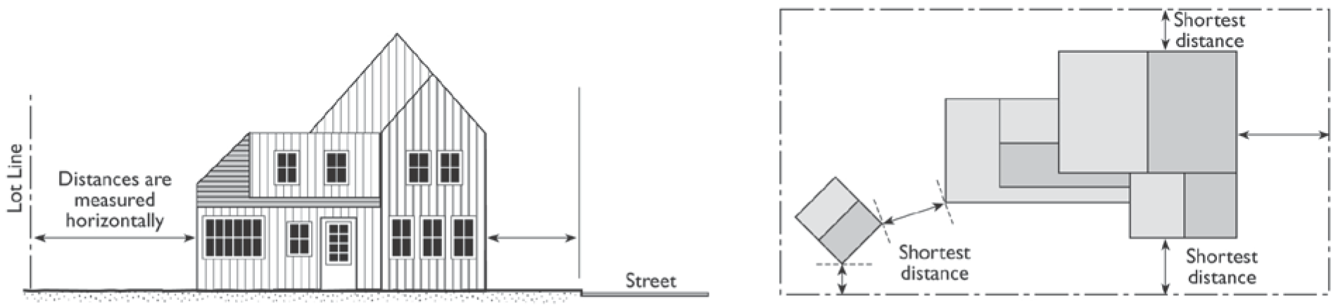
FIGURE 11-2-3.C: MEASURING DISTANCES
D.
Measuring Radius. When a specified land use is required to be located a minimum distance from another land use, the minimum distance is measured in a straight line from all points along the lot line of the subject project. In the event the lot line is curved, the separation radius shall also curve in a similar manner to maintain the specified minimum radius distance. The starting point for the measurement shall be the closest point on the outermost property line for the lot or development site of the protected use, including multiple parcel development sites acting as a campus, or sharing parking, access aisles and other appurtenant shared facilities, such as group development sites. The distance shall be measured to the outside nearest wall of the building intended to house the proposed use.
E.
Measuring Height.
1.
Measuring Building Height. Building Height is measured from the average level of the highest and lowest point of that portion of the lot covered by the building to the mean point between the plate line (where the vertical wall attaches to the roof) and the highest point of the roof ridge, or to the top of a parapet wall or flat roof.
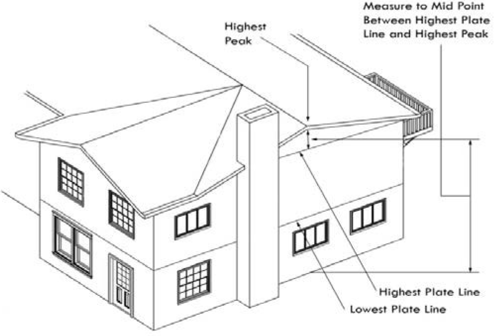
FIGURE 11-2-3.E.1: MEASURING HEIGHT GABLE OR HIP ROOF
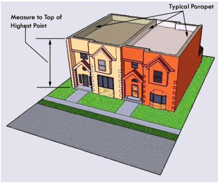
FIGURE 11-2-3.E.2: MEASURING HEIGHT FLAT ROOF WITH PARAPET
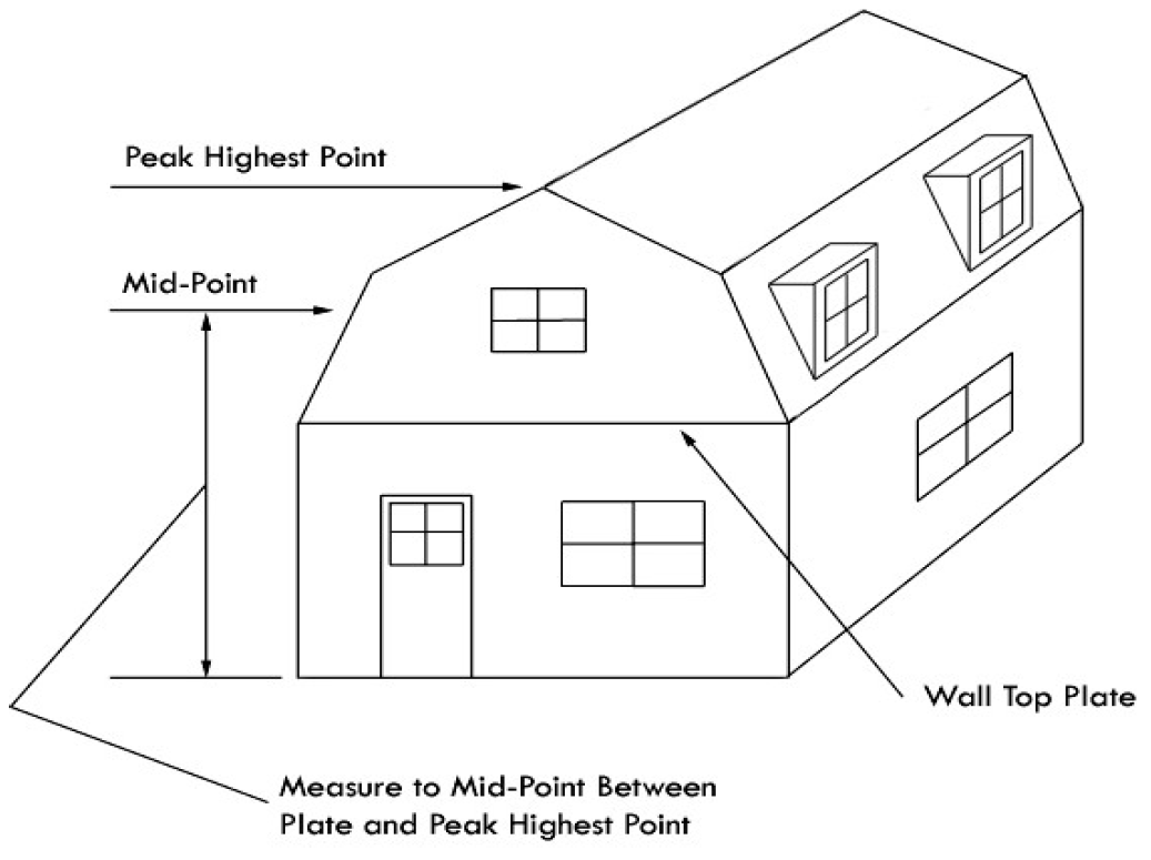
FIGURE 11-2-3.E.3: MEASURING HEIGHT MANSARD or GAMBREL ROOF
2.
Measuring Height of Other Structures. The height of other structures such as fences is the vertical distance from the ground level immediately under the structure to the top of the structure. Special measurement provisions are also provided below:
a.
Measuring the Height of Fences on Retaining Walls. The height of a fence that is on top of a retaining wall is measured from the ground level on the highest side of the fence and wall.
b.
Measuring the Height of Decks. Deck height is determined by measuring from the ground to the top of the floor of the deck.
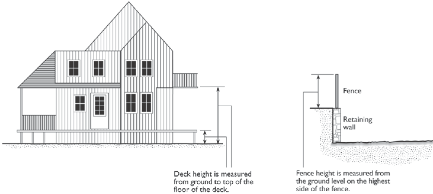
FIGURE 11-2-3.E.4: MEASURING HEIGHT DECKS AND FENCES ON RETAINING WALLS
F.
Measuring Lot Width and Depth.
1.
Lot Width. Lot width is the horizontal distance between the side lot lines, measured at right angles to the lot depth. Minimum lot width is measured perpendicular to the lot depth at both the front and rear setbacks, based on the applicable zoning district applied to the property.
2.
Lot Depth. Lot depth is measured along an imaginary straight line drawn from the midpoint of the front property line of the lot to the midpoint of the rear property line or to the most distant point on any other lot line where there is no rear lot line.
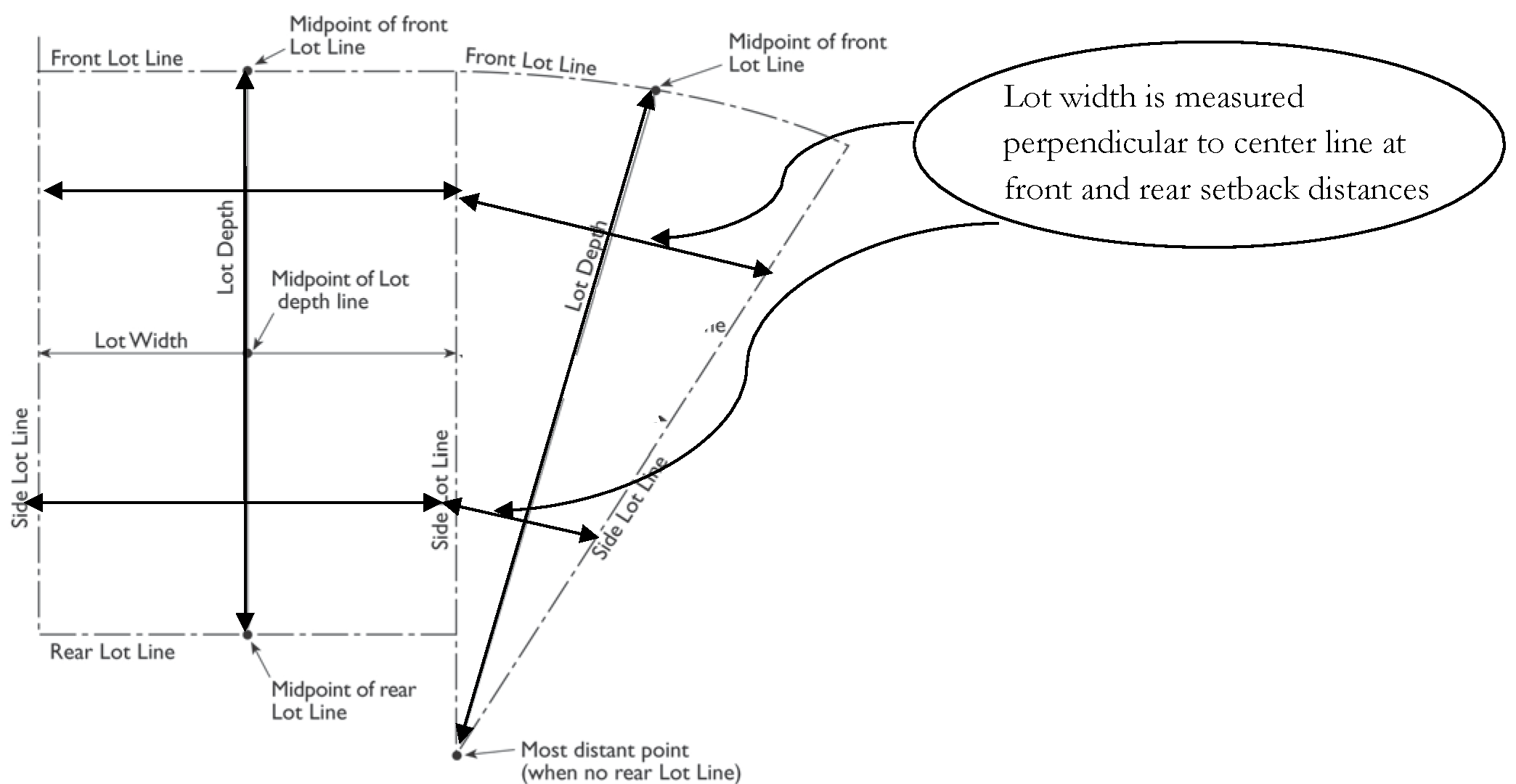
FIGURE 11-2-3.F: MEASURING LOT WIDTH AND DEPTH
G.
Determining Average Slope. The average slope of a parcel is calculated using the following formula: S = 100(I) (L)/A, where:
1.
S = Average slope (in percent).
2.
I = Contour interval (in feet).
3.
L = Total length of all contour lines on the parcel (in feet).
4.
A = Area of subject parcel (in square feet).
H.
Determining Floor Area.
1.
Gross Floor Area. As defined in Chapter 87, includes the floor area of garages, carports, ventilation shafts, shafts, elevators, stairways, corridors, bathrooms, mechanical rooms, closets, storage and equipment storage rooms, open porches, balconies, courts, atriums, lobby areas, basements, and attics.
2.
Floor Area (Net Floor Area). As defined in Chapter 87, excludes the floor area of garages, carports, ventilation shafts, shafts, elevators, stairways, corridors, bathrooms, mechanical rooms, closets, storage and equipment storage rooms, open porches, balconies, courts, atriums, lobby areas, basements, and attics.
I.
Determining Floor Area Ratio. The Floor Area Ratio (FAR) is the ratio of the floor area of all principal and accessory buildings on a lot to the lot area. To calculate FAR, floor area is divided by lot area, and typically expressed as a decimal. For example, if the floor area of all buildings on a lot totals 20,000 square feet, and the lot area is 10,000 square feet, the FAR is expressed as 2.0.
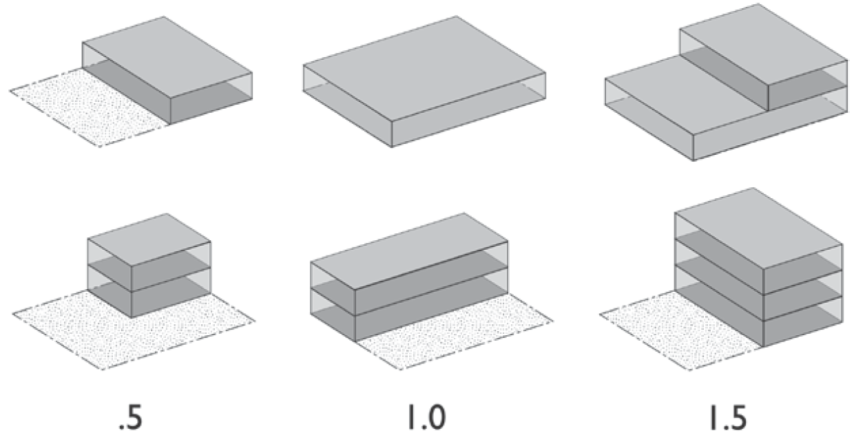
Figure 11-2-3.1: Determining Floor Area Ratio
J.
Determining Building Coverage. Building coverage is the ratio of the total footprint area of all structures on a lot to the net lot area, typically expressed as a percentage. The total footprint of all principal and accessory structures, including garages, carports, covered patios, and roofed porches, is used to calculate building coverage; except the calculation excludes the following areas:
1.
Decks, patio slabs, landings, balconies and stairways (less than 6-feet in height), when unenclosed, unroofed, and/or uncovered;
2.
Eaves and roof overhangs projecting up to two-and-a-half feet from a building wall;
3.
Trellises and similar structures that do not have solid roofs;
4.
Swimming pools and hot tubs that are not enclosed in roofed structures or decks; and
5.
One small, non-habitable accessory structure under 120 square feet and under seven feet high. All other accessory structures are included in building coverage.
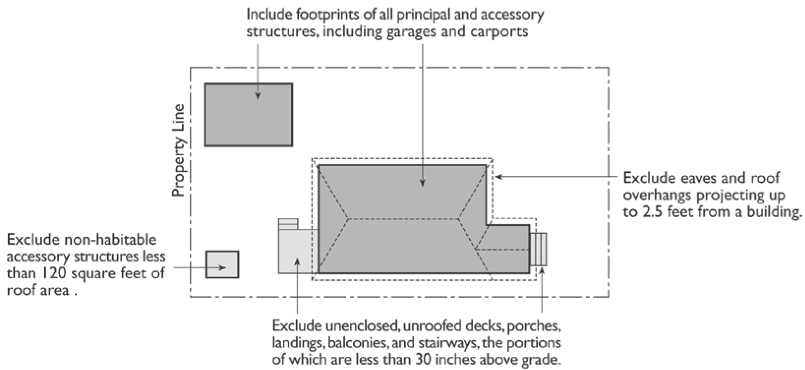
FIGURE 11-2-3.J: DETERMINING BUILDING COVERAGE
K.
Determining Lot Frontage.
1.
Corner Lot. The front of a lot is the narrowest dimension of the lot with street frontage.
2.
Through Lot (Double Frontage Lot). The front yard borders the street primarily used as frontage by neighboring lots. If both street fronts of the Through Lot are adjacent to lots that also front onto the same street, both street fronts of the though lot shall be considered as required front yards for the purpose of determining building setbacks and fence height requirements.
L.
Determining Setbacks for Yards. A setback line defining a required yard is parallel to and at the specified distance from the corresponding front, side, or rear property line. The following special regulations for determining yards apply when a lot abuts a proposed street or alley:
1.
Yards Abutting Planned Street Expansions. If a property abuts an existing or proposed street for which the existing right-of-way is narrower than the right-of-way ultimately required for the street as determined by the City Council through the latest adopted transportation and/or street plan, the required setback shall be established from the future right-of-way rather than the property line. In the event that the street is not listed under the latest adopted transportation plan, the street width shall be determined based on the street classification and right-of-way width requirements specified in Title 9, Chapter 6 of the Mesa City Code.
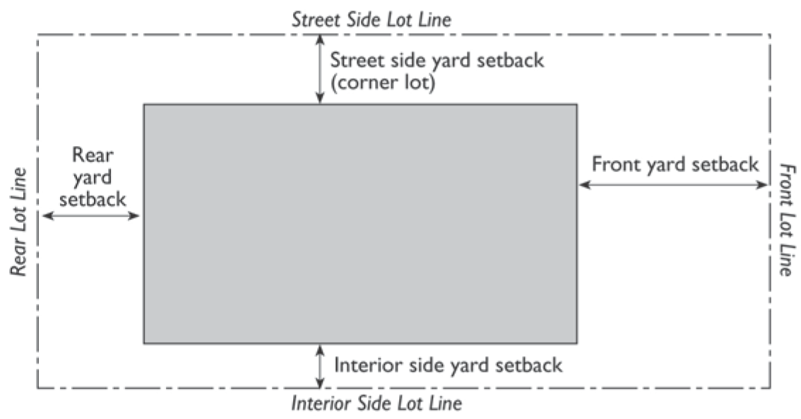
FIGURE 11-2-3.L: DETERMINING SETBACKS
2.
Yards on Alleys.
a.
If a side lot line abuts an alley, the yard shall be considered an interior side yard rather than a corner side yard.
b.
In computing the minimum yard for any lot where such yard abuts an alley, no part of the width of the alley may be considered as part of the required yard except rear yards in RS districts, as specified by Section 11-5-3(D).
M.
Measuring Signs. The height of signs is measured in the same method as the height of other structures. Calculation of sign area is described in Article 5, Signs.
(Ord. No. 5592, § 1, 12-1-20; Ord. No. 5593, § 1, 12-1-20; Res. No. 12269, § 1, 9-23-24; Ord. No. 5883, § 3, 10-7-24)
11-2-4: - RULES OF INTERPRETATION
The Zoning Administrator shall interpret any provision or any method of measurement not expressly identified in this Chapter, and provide clarification and determination of these rules and their application to a specific site. The Zoning Administrator shall maintain a record of these interpretations.
The Particular Controls the General
Whenever a general provision in a rule shall be in conflict with a particular provision in the same or another rule, the two shall be construed, if possible, so that effect may be given to both. If the conflict between the two provisions is irreconcilable, the particular provisions shall prevail and shall be construed as an exception to the general provision, unless the general provision shall be promulgated later and it shall be the manifest intention of the Supreme Court that such general provision shall prevail.
(Ord. No. 5447, 6-4-18)
11-3-1: - DISTRICTS ESTABLISHED
The City shall be classified into districts or zones. The designation and regulation of which are set forth in this Ordinance.
A.
Base Zones. Base zones into which the City is divided are established as follows:
B.
Overlay Zones. Overlay zones, one or more of which may be combined with one or more base districts, are established as follows:
C.
Community Character Designators. Recognizing that not all areas of the City are the same, two community character designators have been established to enhance some multi-residence, commercial and mixed-use districts. These designators are combined with the base district abbreviations in order to establish area-specific development standards according to the intended development character.
1.
Urban (-U). This designation is intended for areas with an urban character, where buildings are built close to the street and sidewalk to provide a close relationship between pedestrians and shops. Site and building design standards will reinforce this character and require treatments that provide an interesting, safe and comfortable pedestrian environment. This designation may apply to some areas where a few auto-oriented uses exist, but where creating, restoring, or maintaining a pedestrian character is called for in the General Plan, a Sub-Area Plan or other City policy.
2.
Auto-Oriented (-A). This designation is intended for areas that provide for easy automobile access. Examples include Large Commercial Development buildings that may be located at the back or side of a site with parking in front. Standards are intended to mitigate the impact of the parking lots and buffer adjacent residential areas.
3.
Associated Districts. The districts that may utilize the character designators are as follows:
D.
References to Classes of Base Districts. Throughout the Ordinance, base zoning districts may be referred to as a group or in a singular manner through the use of the associated words listed as "Synonymous Terms" in the table below, based on the context of how the phrase is used.
11-3-2: - OFFICIAL ZONING MAP AND DISTRICT BOUNDARIES
The boundaries of the zones established by this Ordinance are not included in this Ordinance but are shown on the Official Zoning Map maintained by the City. The Official Zoning Map, together with all legends, symbols, notations, references, zoning district boundaries, map symbols, and other information on the maps, has been adopted by the City Council and are hereby incorporated into this Ordinance by reference, together with any amendments previously or hereafter adopted, as though they were fully included here.
A.
Uncertainty of Boundaries. Where uncertainty exists as to the boundaries of any district shown on the Official Zoning Map, the following rules shall apply:
1.
Boundaries indicated as approximately following property or land parcel lines, street or alley rights-of-way, city limits, or extraterritorial boundary lines shall be construed as following such lines, limits or boundaries.
2.
In the case of un-subdivided property or where a district boundary divides a lot and no dimensions are indicated, the following shall apply:
a.
Lots Greater than One Acre. The location of such boundary shall be determined by the use of the scale appearing on the Official Zoning Map.
b.
Lots Less than One Acre. The lot shall be deemed to be included within the zone which is the more restrictive.
3.
In the case of any remaining uncertainty, the Zoning Administrator shall determine the location of boundaries.
4.
Where any public street or alley is officially vacated or abandoned, the land underlying the street or alley will be added to abutting lots as required by state law. The regulations that applied to the abutting parcel or parcels before the vacation or abandonment shall apply to the entire new larger parcel or parcels that result from such vacation or abandonment.
5.
Where any private right-of-way or easement of any railroad, railway, transportation or public utility company is vacated or abandoned the land underlying the right-of-way or easement shall be added to abutting lots as required by state law. If the abandoned or vacated property is unclassified, the property shall be automatically classified as being in the same zone of the abutting land to which it is added.
B.
Conditions. Conditions imposed by special ordinance in conjunction with amendments to the Zoning Map are referenced by separate files maintained in the Planning Division and are made a part of the Zoning Map.
(Ord. No. 4467, 10-24-05)