
Mesa City Zoning Code
ARTICLE 6
FORM-BASED CODE
CHAPTER 56 - FORM-BASED CODE OVERVIEW[1]
Editor's note— Ord. No. 5948, § 1, adopted July 1, 2025, repealed the former Ch. 56, §§ 11-56-1—11-56-7, and enacted a new Ch. 56 as set out herein. The former Ch. 56 pertained to similar subject matter and derived from Ord. No. 5514, § 1, 7-8-19.
CHAPTER 57 - RESERVED[2]
Editor's note—Ord. No. 5948, § 1, adopted July 1, 2025, repealed the former Ch. 57, § 11-57-1. The former Ch. 57 pertained to maps.
CHAPTER 58 - BUILDING FORM STANDARDS[3]
This Chapter provides regulatory standards for land use and building form within the Transect Zones.
(Ord. No. 5948, § 1, 7-1-25)
Editor's note—Ord. No. 5948, § 1, adopted July 1, 2025, repealed the former Ch. 58, §§ 11-58-1—11-58-12, and enacted a new Ch. 58 as set out herein. The former Ch. 58 pertained to similar subject matter, and derived from Ord. No. 5514, § 1, 7-8-19; Ord. No. 5576, § 1, 6-1-20; Ord. No. 5632, § 1, 7-8-21; Ord. No. 5758, § 1, 12-8-22; Ord. No. 5759, § 1, 12-8-22; Ord. No. 5813, § 1(Exh. 1), 10-16-23.
11-56-1: - PURPOSE
The purpose of the Form-Based Code is to implement the community's vision for a vibrant, walkable, mixed-use urban environment in downtown Mesa and surrounding areas. The standards outlined in the following chapters are intended to:
A.
Preserve and enhance community character.
B.
Encourage appropriately-scaled infill and development.
C.
Reinforce a pattern of walkable neighborhoods and retrofit those that are not walkable.
D.
Support a diverse range of housing options at appropriate locations along the Transect.
E.
Foster and sustain small local businesses.
F.
Establish a framework of well-designed streets that are safe and accessible for pedestrians and cyclists.
(Ord. No. 5948, § 1, 7-1-25)
11-56-2: - AUTHORITY AND APPLICABILITY
A.
The Form-Based Code (FBC) replaces the zoning regulations for parcels designated with a Transect Zone.
1.
Area of Initial Application. In its initial application, the FBC was applied to the Downtown and Pioneer/Temple Neighborhoods as a floating zone, as shown on Map 11-56-2.A.1 below. The rezoning to a designated transect zone is made effective through completion of the opt-in process (Subsections C and D, below).
2.
Areas of Future Use. FBC and transect zones may be established in other areas of the City as set forth in Chapter 63: Smart Growth Community Plans (SGCP).
3.
Relationship of FBC to Zoning Ordinance. This FBC is a subpart of the Zoning Ordinance. All provisions of the Zoning Ordinance apply within the areas mapped with Transect Zones unless otherwise provided in Article 6: Form-Based Code.
4.
Applicability of Non-Transect Development Standards. The FBC shall be considered in combination with any applicable standards in Article 3: Overlay Districts and Chapter 31 of Article 3: Standards for Specific Uses. Requirements referenced in Chapter 30: General Site Development Standards may be applicable when directly referenced as part of a requirement of Article 6: Form-Based Code.
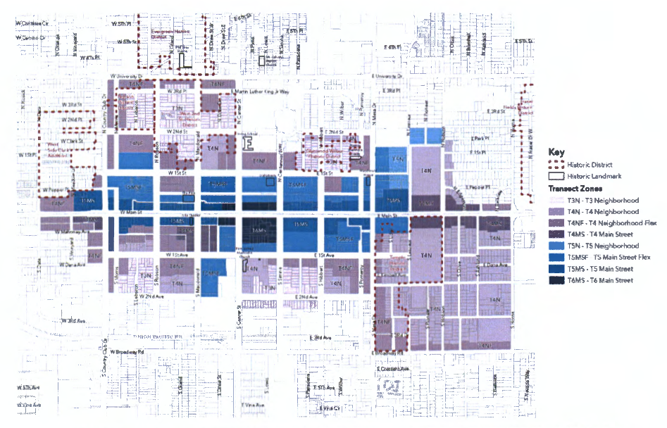
MAP 11-5602.A.1: DOWNTOWN AND PIONEER/TEMPLE NEIGHBORHOODS REGULATING PLAN
B.
Designation of Transect Zones, Status of Existing Zoning Districts, and Optional Use of Floating Zone. When adopting a regulating plan, the City Council may change the existing zoning district to a transect zone or retain the existing zoning district until such time as a property owner chooses to opt-in to the transect zone (floating zone).
1.
When a floating zone is adopted, if the existing zoning district is retained, a property owner may continue to apply the standards of the non-transect zone to the entire parcel (see Subsection D, below) or, may choose to designate the entire parcel as, and apply the standards of a transect zone, pursuant to the Opt-in Procedures in this Section.
2.
In no case may a parcel be developed using a mixed set of standards from both transect and non-transect zones at the same time, unless a transect requirement makes reference to a non-transect standard.
C.
Opt-In Procedures. To opt-in, a property owner shall sign before a notary public a "Form-Based Code Opt-In" form prepared by the Zoning Administrator and approved by the City Attorney's Office.
1.
Such form shall state that the Transect Zone standards are in effect for the identified parcel(s) as of the signature date of the Opt-in Form.
2.
The requirements of the previous zoning district are no longer applicable for that site.
3.
Any future development shall conform with the standards of the FBC.
D.
Other Agreements. If conflicts occur between the requirements of this FBC and applicable standards adopted by City Council as part of any other agreement, the more restrictive requirements shall apply.
(Ord. No. 5948, § 1, 7-1-25)
11-56-3: - EFFECT ON EXISTING DEVELOPMENT AND LAND USES AFTER OPT-IN TO FBC
A.
Complies with FBC. Existing development and land uses that comply with all applicable requirements of Article 6: Form-Based Code of this Title may continue to operate and shall only be altered or replaced in compliance with Article 6: Form-Based Code.
B.
Non-compliance with FBC. Any development or land use that was lawfully built in conformance with non-Transect Zone requirements (the Zoning Ordinance), and does not comply with the requirements effective for the applicable Transect Zone, shall be considered as legal, but nonconforming, and may continue to operate in compliance with the City's regulations for nonconformities in the Zoning Ordinance (see Zoning Ordinance Chapter 36: Nonconforming Uses, Structures and Lots). Sites that are non-conforming relative to site development standards may redevelop or expand only in conformance with the following:
1.
Existing structures may stay in place without modification or demolition, except as necessary to accommodate redevelopment or expansion.
2.
When the expansion of an existing development amounts to an increase of 20% or less of the existing floor area, up to a maximum of 1,000 square feet, then such expansion may proceed in accordance with any conditions attached to the Zoning Clearance by the Planning Director.
3.
When expansion of an existing development amounts to a 21% or greater increase of the existing floor area, or the total floor area exceeds 1,000 square feet, then such expansion may only proceed in accordance with an approved Substantial Conformance Improvement Permit (SCIP), as per Chapter 73 of this Ordinance. Said SCIP application shall be reviewed prior to issuance of a Zoning Clearance.
(Ord. No. 5948, § 1, 7-1-25)
11-56-4: - PERMIT PROCESSING, REZONING AND ADMINISTRATION
A.
Processing and Procedures. The standards, permits, procedures, and other requirements of this Code shall be administered and enforced per Zoning Ordinance requirements, unless specifically stated otherwise in this FBC.
B.
Text Amendments. Text amendments to this FBC, or to adopted regulating plans, shall be processed in accordance with the procedures and standards found in Chapter 76: Amendments to Zoning Map.
C.
Rezoning of Parcels within Adopted Regulating Plans.
1.
Parcels within Adopted Regulating Plans - Rezone from One Transect Zone to Another Transect Zone. Amendments to the floating zone (Transect Zones) as shown on Map 11-56-2.A.1 shall be processed in accordance with the procedures and standards in Chapter 76: Amendments to Map.
2.
Properties Outside of Adopted FBC Mapped Area(s) - Rezone from a Non-Transect Zone to a Transect Zone.
a.
Requests for Transect Zones outside of areas with adopted regulating plans shall include all Smart Growth Community Plan (Chapter 63) requirements when an application includes a request for a regulating plan and the project involves:
i.
Parcels of ten (10) acres or greater; or
ii.
Parcels designated by City Council as a redevelopment site.
b.
Requests for Transect Zones on parcels other than those described by Subsection C(2)(a), above:
i.
Parcels or project sites abutting and/or coterminous with an existing regulating plan may request rezoning to a Transect Zone in conformance with Chapter 76: Amendments to Zoning Map in the Zoning Ordinance. Such rezoning to a Transect Zone shall be a natural extension of the standards adopted in the abutting and/or coterminous regulating plan and include the updating of that regulating plan to include the area being rezoned.
ii.
Other parcels may request rezoning to a Transect Zone only by determination of the Planning Director that a successful application will result in more complete conformance with goals and objectives as found in the Mesa General Plan, applicable sub-area plans, and other adopted Council policies, than the use of non-Transect Zones and requirements.
D.
Conditional Use Permit Procedures. Uses or activities of the FBC requiring an Administrative Use Permit, Council Use Permit, Special Use Permit, or Temporary Use Permit shall be processed according to the requirements of Chapter 70: Conditional Use Permits.
E.
Zoning Clearance - Review Process for FBC Compliant Projects.
1.
Zoning Clearance Required before Application for Building Permit. Prior to submitting a building permit, an application for a Zoning Clearance shall be filed with the Development Services Department, who shall then review the project for compliance with the requirements of FBC.
a.
Fee Payment. Payment of a fee for this service shall be in accordance with the adopted Planning Division fee schedule.
b.
Design Review. Upon determination that one (1) or both of the two (2) following items is present, the Planning Director may elect to also review the project under the provisions of Design Review, Chapter 71 of this Title:
i.
That the project largely conforms to the minimum requirements of the FBC, and may benefit from review and comments generated by the Design Review process to achieve full compliance, or
ii.
That the project conforms to the minimum requirements of the FBC, but fails to contribute to the creation of a visually interesting built environment that includes a variety of building styles and designs with well-articulated structures that present well designed building façades on all sides, rooflines, and building heights within a unifying context that encourages increased pedestrian activity and promotes compatibility among neighboring land uses within the same or different districts.
2.
Zoning Clearance Issuance. Zoning Clearance is issued after the Planning Director, or designee, determines the project complies with the minimum requirements of the FBC and Design Review, if applicable. Zoning Clearance allows an application to be filed for a construction or a building permit in accordance with Title 4 of the Mesa City Code. Concurrent review of applications for building permit and FBC Zoning Clearance may be requested and allowed upon agreement by both the Planning Director and Building Official.
3.
Zoning Clearance Modification. Any modification to an issued Zoning Clearance shall be reviewed according to the review process in Subsection (1) above.
F.
Variances. In the event that an applicant believes special circumstances applicable to a property, a variance may be requested in accordance with provisions set forth in Chapter 80: Variances.
G.
Administrative Modifications to Form-Based Code Standards.
1.
Purpose and Intent. The purpose of this section is to provide an administrative process to allow minor administrative modifications to specific standards of Article 6: Form-Based Code (FBC). The intent of this section is to allow relief when the application of specific FBC standards creates practical difficulties developing the property and to allow flexibility in order to create high quality development while maintaining the intent of the FBC which focuses on physical form rather than the separation of uses as an organizing principle.
2.
Process for Requesting Administrative Modification. An applicant may only apply for an administrative modification under this section concurrently with an application for Zoning Clearance, Administrative Use Permit, Special Use Permit, or Council Use Permit. An administrative modification may be requested for a single building or for a specified area. An application for an administrative modification must include a narrative that specifically identifies and describes the administrative modification sought.
3.
Eligible Modifications. An administrative modification is limited to and must comply with the following limitations and requirements:
a.
No more than a 10% increase to the maximum build-to line.
b.
No more than a 10% reduction of a required side and/or rear setback if adjacent to public right-of-way or public open space.
c.
No more than a 10% reduction to the required façade within the façade zone.
d.
No more than a 20% reduction to the ground floor and upper floor ceiling heights for building types with 12 or less units.
e.
A reduction in the required ground floor building transparency if the project is located outside of the Downtown Pedestrian Area (DPA). Any reduction in the required ground floor building transparency shall include pedestrian scale design, building articulations and fenestrations, and superior façade materials such as brick, stone, architectural precast concrete, etc.
f.
No more than 10% increase or reduction of any other exterior design feature not specifically stated above.
4.
Administrative Decision Process and Review Criteria. An administrative modification can be approved as submitted, approved with conditions or modifications, or denied. The basis for approval or denial will be included in the written decision. An administrative modification shall only be granted if the Planning Director determines that the requested modification strictly complies with Subsection (3) of this Section and conforms to all of the following findings:
a.
Conforms to the purpose and intent of the City's General Plan and Zoning Ordinance.
b.
Conforms to the intent of the Transect Zone for the proposed development.
c.
Does not change the intended building types and form within a Transect Zone.
d.
Results in a superior building design standard including pedestrian scale design.
e.
Is necessary for the proposed development.
5.
Administrative Modification Request Referral. The Planning Director may refer a request for an administrative modification to the Design Review Board for review and recommendation. If referred to the Design Review Board, the applicant shall address the recommendations of the Design Review Board. The Planning Director shall have the final authority to approve the request for administrative modifications. Any request for a modification other than those listed above is considered major and shall follow the processes established in the Zoning Ordinance.
6.
Appeals.
a.
Process. The applicant, the property owner, or any other person aggrieved by a decision may appeal the Planning Director's decision to the Planning and Zoning Board in accordance with Section 11 -77 of the Zoning Ordinance. If the Planning Director refers the request to the Design Review Board, an applicant or property owner may appeal the Design Review Board decision to City Council in accordance with Chapter 77: Appeals of the Zoning Ordinance.
b.
Evaluation of Administrative Modification Appeals. Appeals of an administrative modification decision are reviewed using the same standards and criteria required for the decision.
(Ord. No. 5948, § 1, 7-1-25)
11-58-2: - APPLICABILITY
A.
The standards within this Chapter shall apply to all proposed development within Transect Zones.
B.
For Nonconforming Uses, Structures, and Lots, See Chapter 36 (Nonconforming Uses, Structures, and Lots).
(Ord. No. 5948, § 1, 7-1-25)
11-58-3: - LAND USE REGULATIONS
Table 11-58-3.A provides the land use regulations for all Transect Zones.
• "P" designates permitted uses.
• "AUP" designates use classifications permitted on approval of an Administrative Use Permit.
• "SUP" designates use classifications permitted on approval of a Special Use Permit.
• "CUP" designates use classifications permitted on approval of an Council Use Permit.
• "TUP" designates use classifications permitted on approval of a Temporary Use Permit.
• "(x)" a number in parenthesis refers to limitation following the table.
• "-" designates a prohibited use.
Separate requirements exist for ground floor uses, uses on upper floor(s), and uses behind an allowed ground floor use.
(Ord. No. 5948, § 1, 7-1-25)
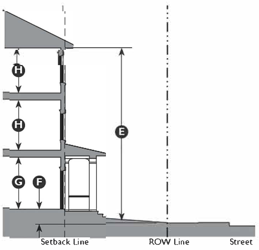
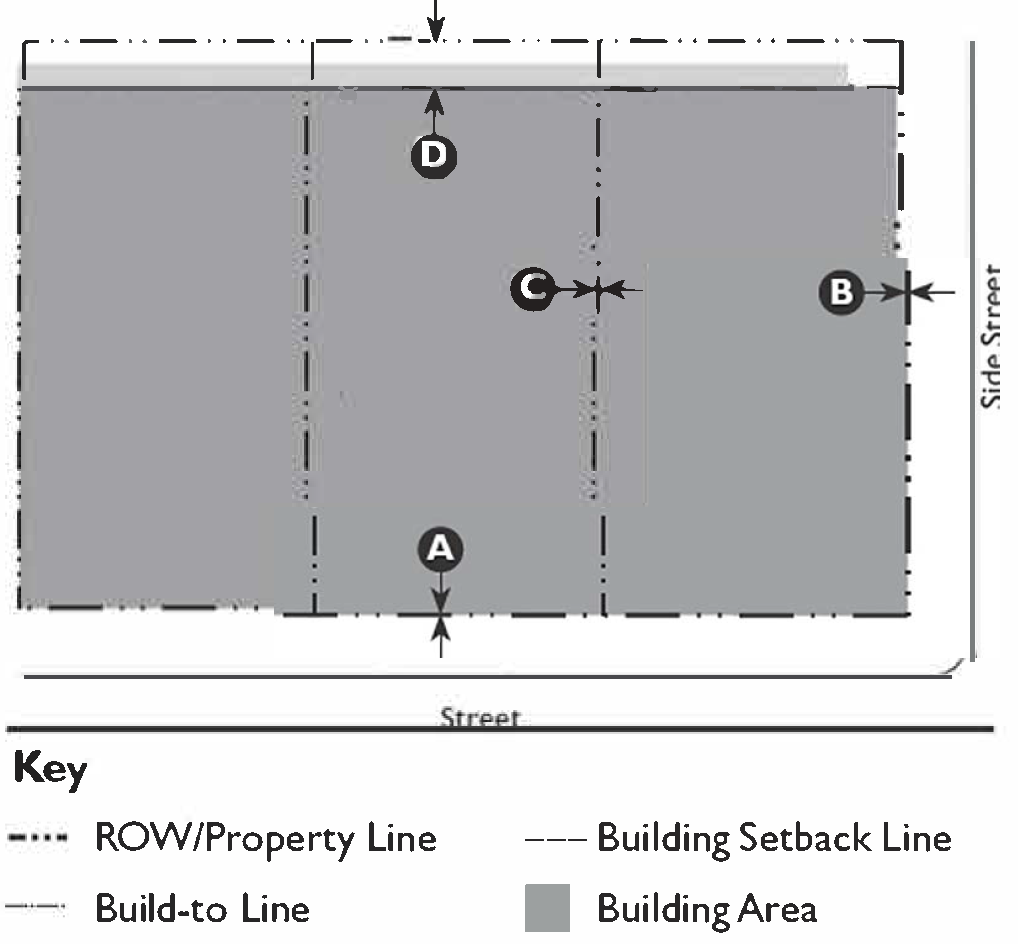
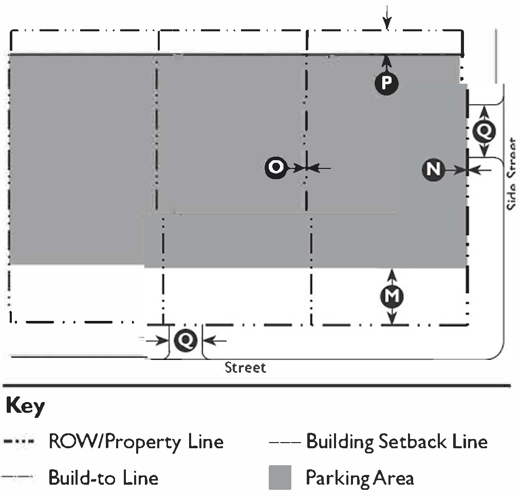
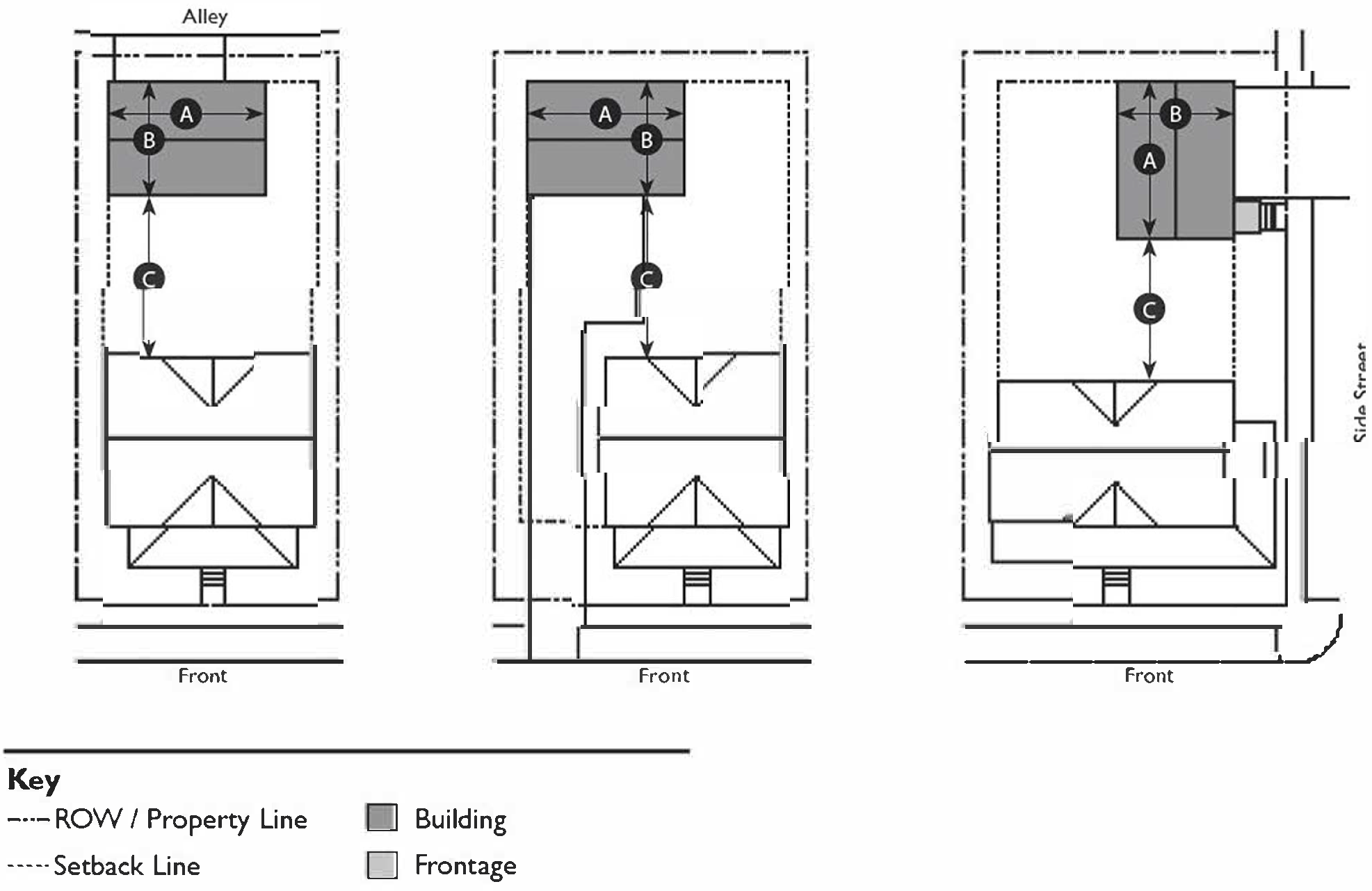
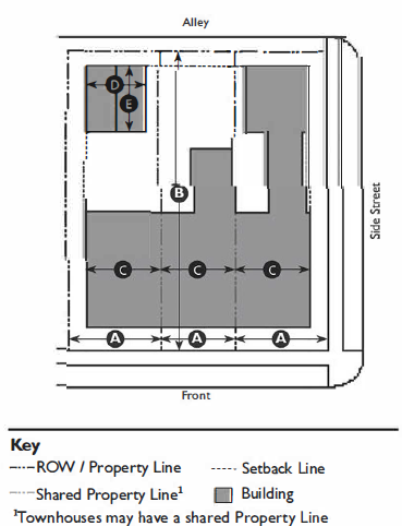
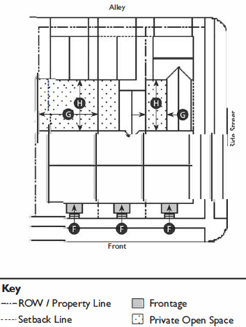
11-58-4: - T3 NEIGHBORHOOD (T3N) STANDARDS
| A. Zone Intent and Description | ||
| To provide a walkable predominantly single-family neighborhood that integrates appropriate multifamily housing types such as duplexes, mansion apartments, and bungalow courts within walking distance to transit and commercial areas. | ||
 | ||
| B. Building Types | ||
| Allowed Building Types |
Carriage House
Single Unit House, Village Single Unit House, Cottage Bungalow Court Duplex Mansion Apartment | See Chapter 59: Building Type Standards for descriptions and regulations |
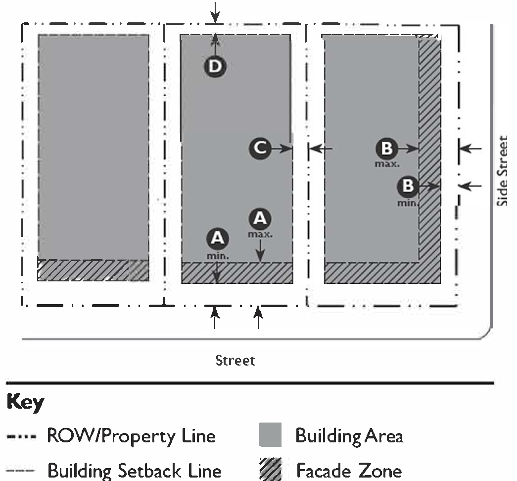
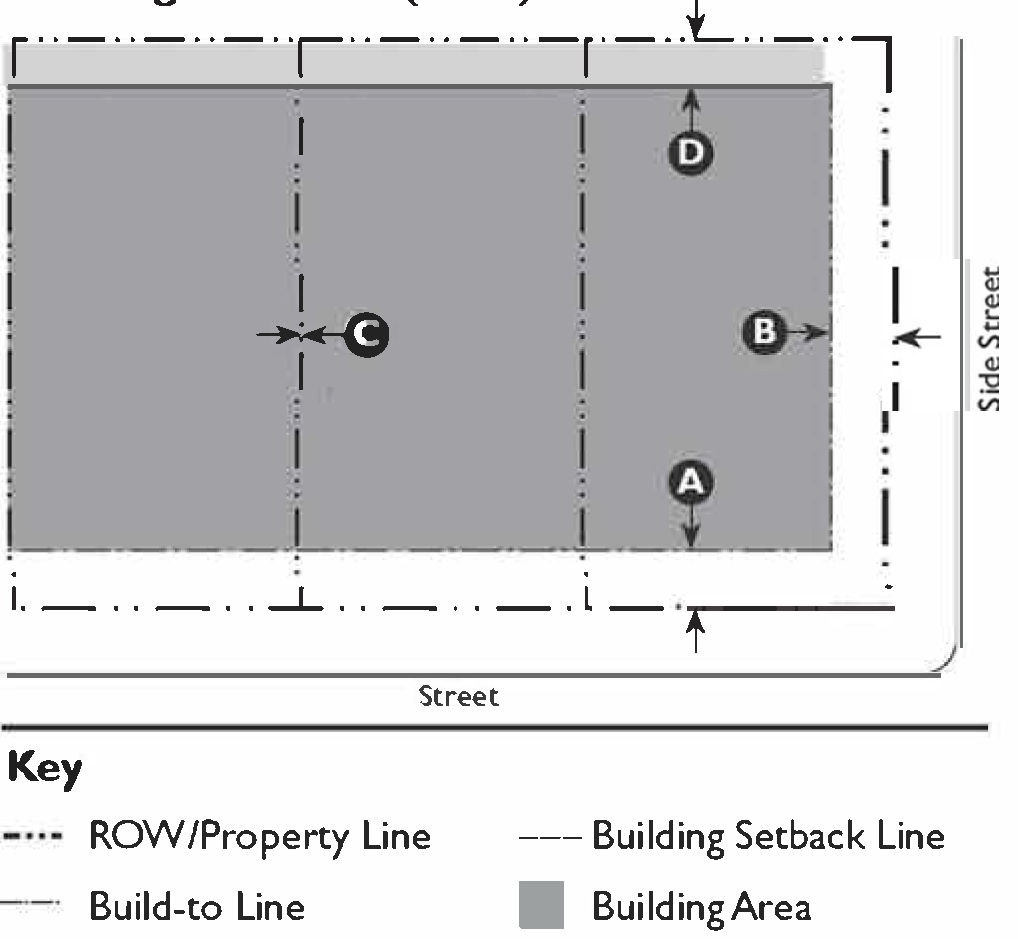
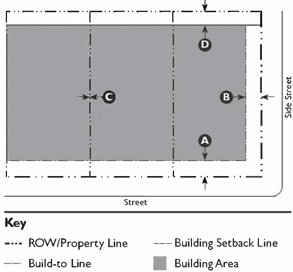
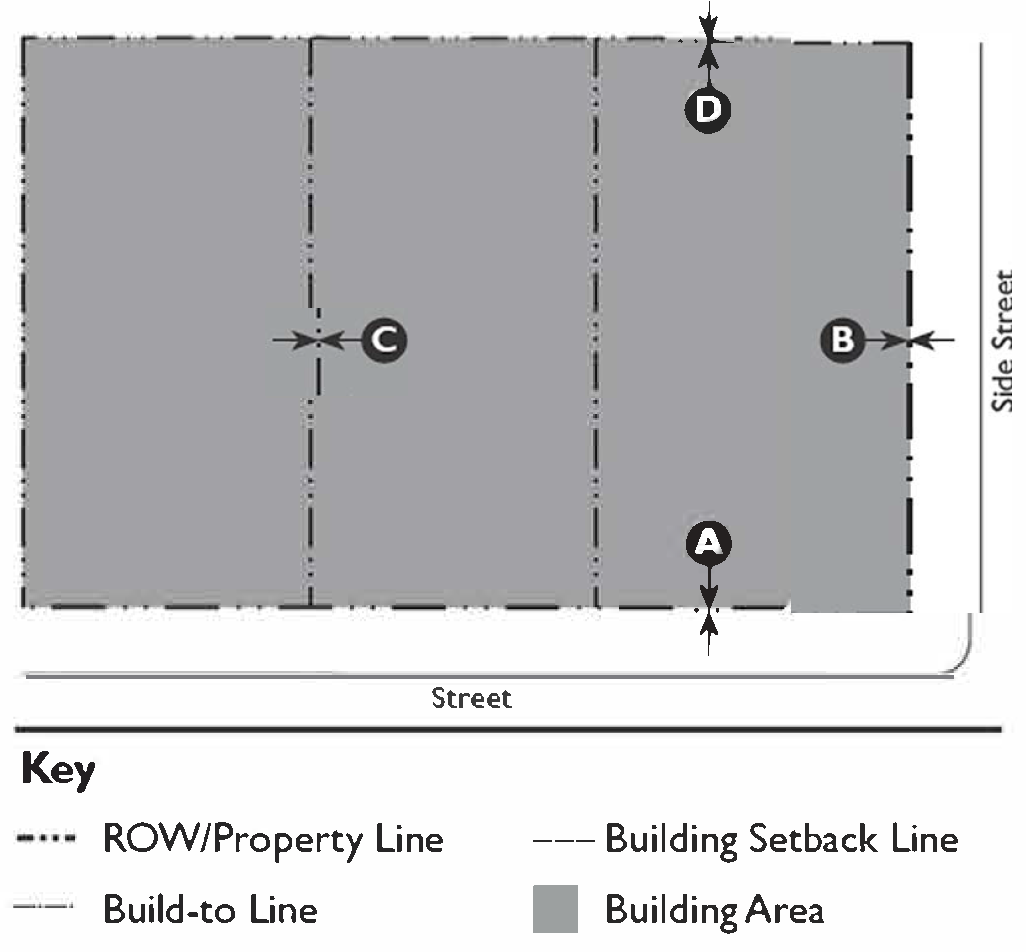
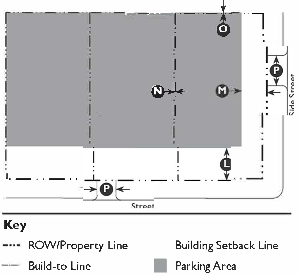
| C. Building Placement | ||
 | ||
| Setbacks (Distance from Property Line/ROW) | ||
| Main Building | ||
| Front | 15' min. 1, 2 , 25' max. 2 | |
| Side Street | 10' min.; 20' max. | |
| Side | 5' min. 3 | |
| Rear | 30' min. | |
| Accessory Structure | ||
| Front | 15' min. 4 | |
| Side Street | 10' min. | |
| Side | 5' min. 3 | |
| Rear | 5' min. | |
| Accessory Dwelling Unit 5 | See Section 11-31-3: Accessory Dwelling Unit | |
| Façade within Façade Zone | ||
| Front | 50% min. | |
| Side Street | 50% min. | |
| Miscellaneous | ||
| Only one Main Building and one Accessory Structure may be built on each lot. | ||
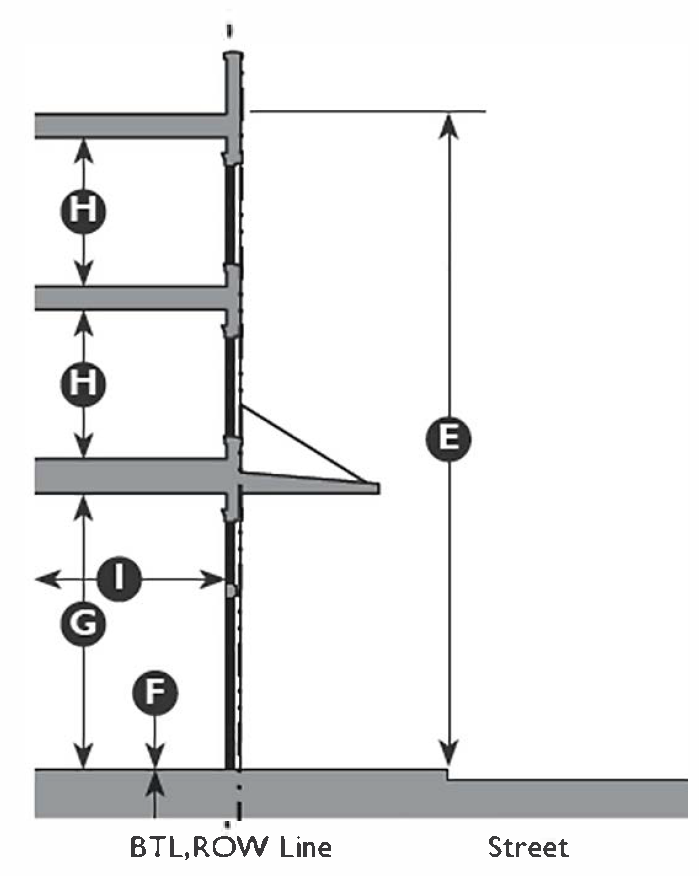
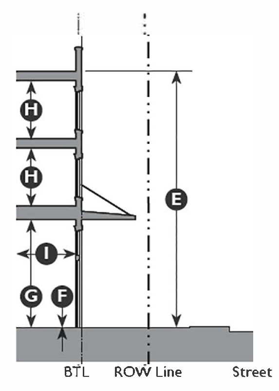
| D. Building Form | ||
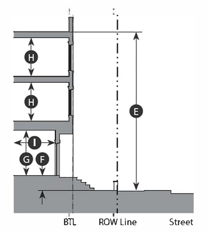
 | ||
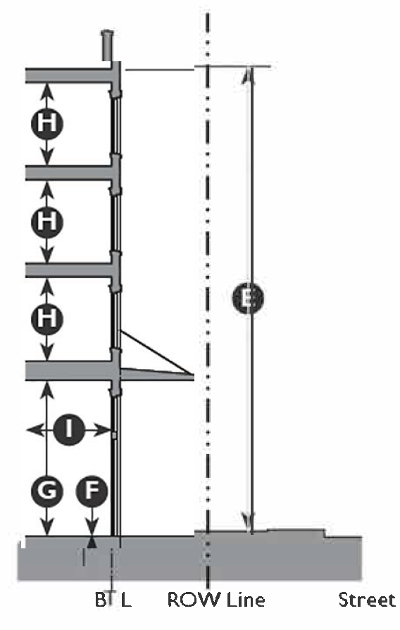
| Height | ||
| Main Building | 2 Stories max. | |
| Ground Floor Ceiling | 10' min. clear | |
| Upper Floor(s) Ceiling | 9' min. clear | |
| Accessory Structure | 1½ stories max. | |
| Accessory Dwelling Unit | See Section 11-31-3: Accessory Dwelling Unit | |
| Footprint | ||
| Per Building Type Standards (see Chapter 59). | ||
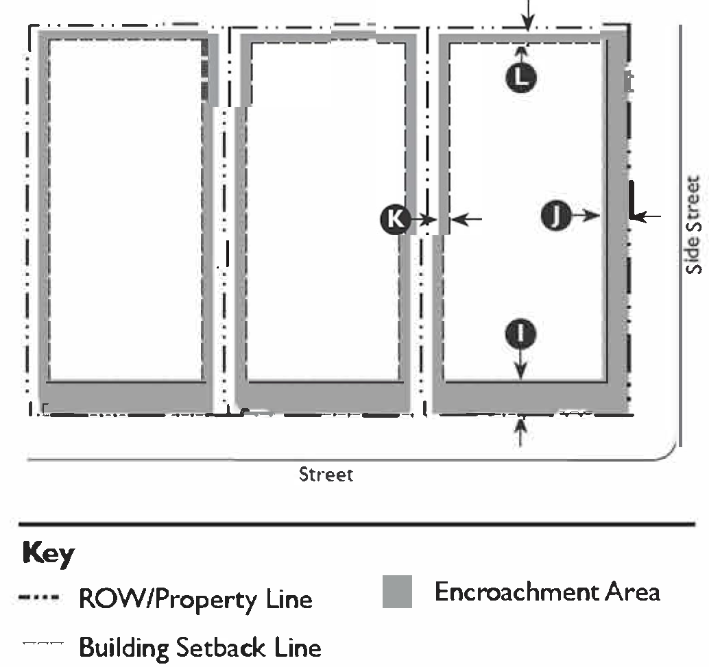
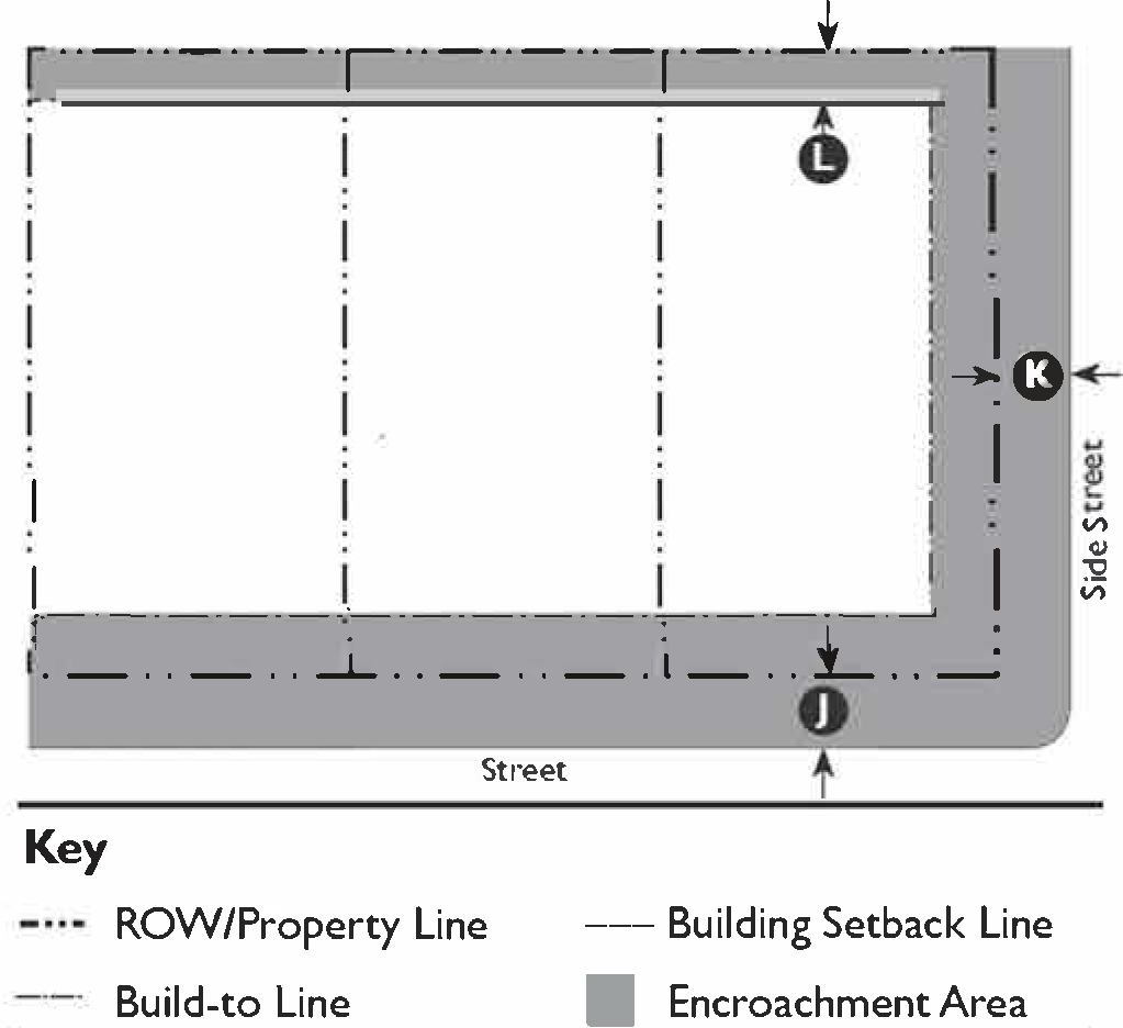
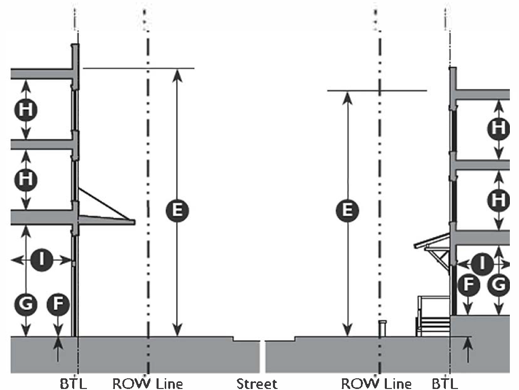
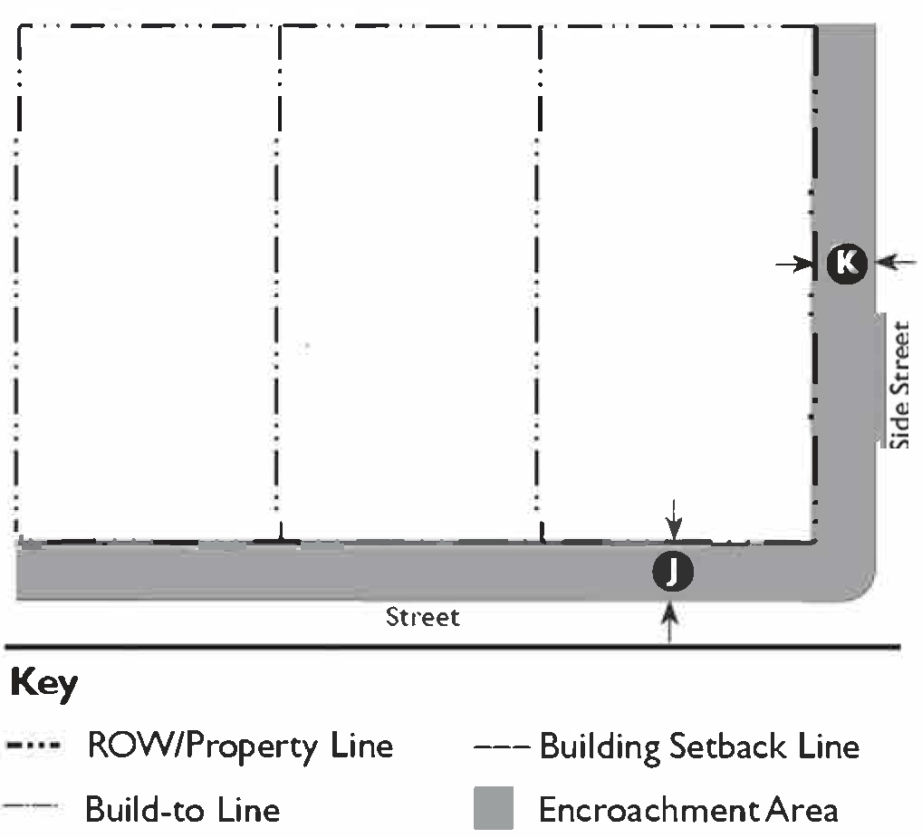
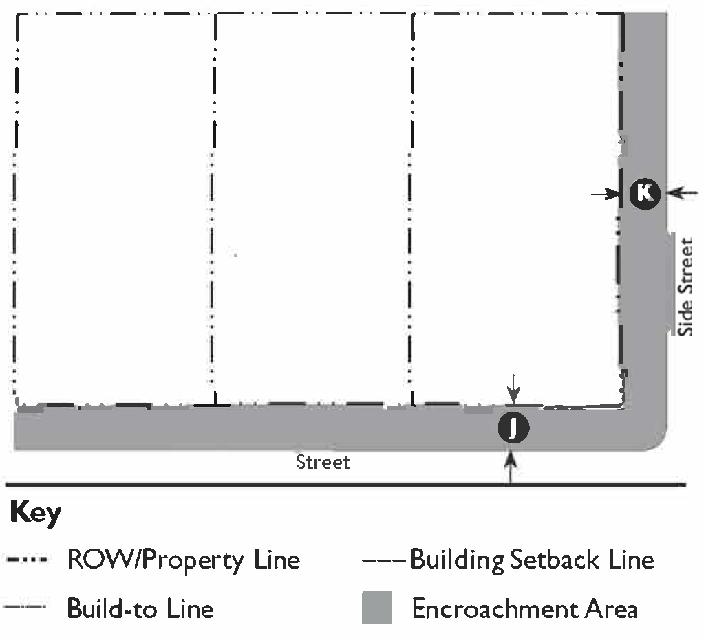
| E. Encroachments | ||
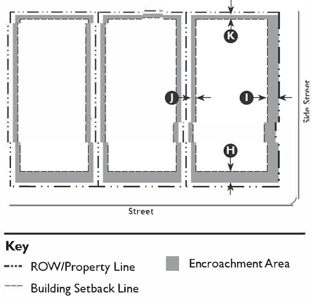 | ||
| Allowed Encroachments | ||
| Front | 10' max. 6 | |
| Side Street | 10' max. 6 | |
| Side | 2'-6" max. 6 | |
| Rear | 2'-6" max. 6 | |
| Miscellaneous | ||
| See Chapter 60: Private Frontage Standards for additional encroachment standards specific to frontage types | ||
| F. Private Frontage Types | ||
| Allowed Private Frontage Types |
Common Yard
Porch, Engaged Porch, Projecting Stoop | See Chapter 60: Private Frontage Standard for private frontage type descriptions and regulations |
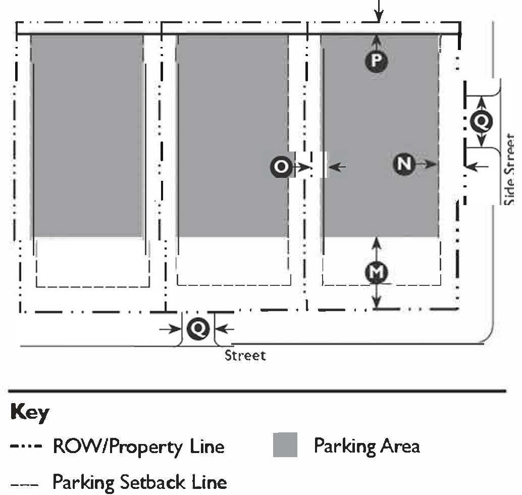
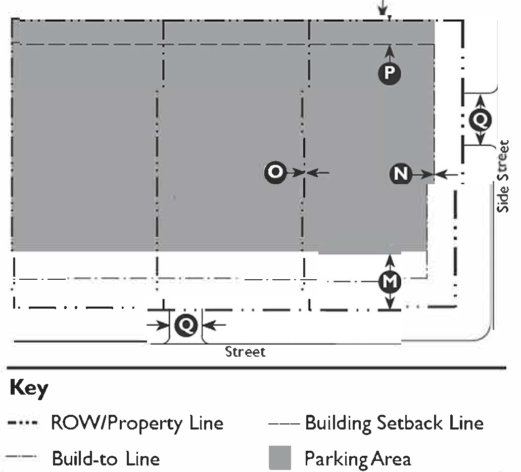
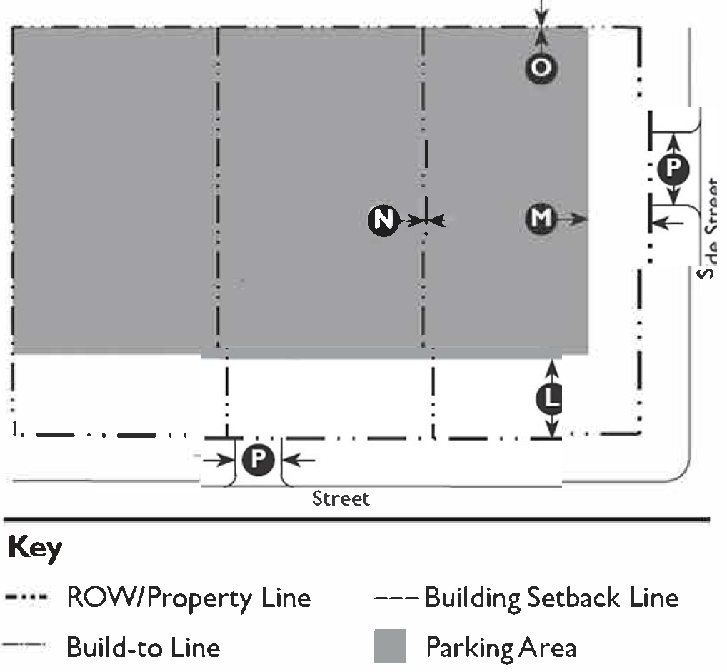
| G. Parking | ||
 | ||
| Required Spaces | ||
| Residential Uses | 1 space per unit min. 7 | |
| Location (Distance from Property Line/ROW) | ||
| Front Setback | 20' min. 8 | |
| Side Street Setback | 15' min. 8 | |
| Side Setback | 5' min. | |
| Rear Setback | 5' min. | |
| Parking Access Drive | ||
| Width | 12' max. | |
| Footnotes: | ||
| 1. Where existing adjacent buildings are located closer to the street than the regulated front setback, a new building may be aligned with the façade of the front most immediately adjacent property. | ||
| 2. For parcels within a designated historic district, the minimum and maximum front setbacks are determined by the setbacks of the existing buildings along the block. | ||
| 3. No side setback required along the common property line between townhouse and/or duplex building types or for accessory structures when in conjunction with a townhouse or duplex building type. | ||
| 4. Accessory Structures may not be placed in front of the main building regardless of the minimum setback. | ||
| 5. Only allowed in conjunction with Single-Unit House, Village: Single-Unit, Cottage, and Duplex Building Types. | ||
| 6. Encroachments are not allowed within a street or public alley, or across a property line. | ||
| 7. No additional parking is required for Accessory Dwelling Units. | ||
| 8. Parking must be placed at least five (5) feet behind the building's façade. | ||
(Ord. No. 5948, § 1, 7-1-25)
11-58-5: - T4 NEIGHBORHOOD (T4N) STANDARDS
| A. Zone Intent and Description | ||
| To provide high quality, medium-density residential building types such as townhouses, small courtyard housing, mansion apartments, duplexes, or fourplexes, all within walking distance to transit and commercial areas. | ||
 | ||
| B. Building Types | ||
| Allowed Building Types 1 : |
Carriage House
Single-Unit House, Village Single-Unit House, Cottage Bungalow Court Duplex Townhouse Mansion Apartment Apartment House Courtyard Building Mid-Rise Main Street Mixed-Use | See Chapter 59: Building Type Standards for descriptions and regulations |
| C. Building Placement | ||
 | ||
| Setbacks (Distance from Property Line/ROW) | ||
| Main Building | ||
| Front | 10' min.; 15' max. 1 | |
| Side Street | 5' min.; 10' max. | |
| Side | 5' min. 2 | |
| Rear | 5' min. | |
| Accessory Structure | ||
| Front | 10' min. 3 | |
| Side Street | 5' min. | |
| Side | 5' min. 2 | |
| Rear | 5' min. | |
| Accessory Dwelling Unit 4 | See Section 11-31-3: Accessory Dwelling Unit | |
| Façade within Façade Zone | ||
| Front | 75% | |
| Side Street | 75% | |
| D. Building Form | ||
 | ||
| Height | ||
| Main Building | 4 stories max. 5 | |
| Ground Floor Finish Level | 18" min. | |
| Ground Floor Ceiling | 10' min. clear | |
| Upper Floor(s) Ceiling | 9' min. clear | |
| Accessory Structure | 2 stories max. | |
| Accessory Dwelling Unit | See Section 11-31-3: Accessory Dwelling Unit | |
| Footprint | ||
| Per Building Type Standards (see Chapter 59). | ||
| Miscellaneous | ||
| Loading docks, overhead doors, and other service entries may not be located on street-facing façades. | ||
| E. Encroachments | ||
 | ||
| Allowed Encroachments | ||
| Front | 10' max. 6 | |
| Side Street | 5' max. 6 | |
| Side | 2'-6" max. 6 | |
| Rear | 2'-6" max. 6 | |
| Miscellaneous | ||
| See Chapter 60: Private Frontage Standards for additional encroachment standards specific to frontage types | ||
| F. Private Frontage Types | ||
| Allowed Private Frontage Types |
Porch, Engaged
Porch, Projecting Stoop Forecourt Dooryard | See Chapter 60: Private Frontage Standards for private frontage type descriptions and regulations |
| G. Parking | ||
 | ||
| Required Spaces | ||
| Residential Uses | 1/1,000 sf min. 7 | |
| Location (Distance from Property Line/ROW) | ||
| Front Setback | 15' min. 8 | |
| Side Street Setback | 10' min. | |
| Side Setback | 5' min. | |
| Rear Setback | 5' min. | |
| Parking Access Drive | ||
| Width | 12' min. 9 | |
| Footnotes: | ||
| 1. Where existing adjacent buildings are in front of the regulated BTL, the building may be set to align with the façade of the front most immediately adjacent property. | ||
| 2. No side setback required along the common property line between townhouse and/or duplex building types or for accessory structures when in conjunction with a townhouse or duplex building type. | ||
| 3. Only allowed in conjunction with Carriage House and Single-Unit House, Single-Unit House, Village, and Cottage Building Types. | ||
| 4. Accessory Structures may not be placed in front of the main building regardless of the minimum setback. | ||
| 5. Five (5) stories maximum permitted for buildings with more than 25% affordable or senior housing or for LEED Gold (or equivalent) certified buildings. | ||
| 6. Encroachments are not allowed within a street, public alley, or across a property line. | ||
| 7. No parking spaces required for the first 2,000 sf of residential use, affordable housing units, senior housing units, or Accessory Dwelling Units. | ||
| 8. Parking must be placed at least five (5) feet behind the building's façade. | ||
| 9. Maximum parking access drive width to be determined by Solid Waste and Fire access requirements. | ||
(Ord. No. 5948, § 1, 7-1-25)
11-58-6: - T4 NEIGHBORHOOD FLEX (T4NF) STANDARDS
| A. Zone Intent and Description | ||
| To provide flexible areas that can accommodate smaller, neighborhood-serving commercial uses in a main street form while allowing for interim uses such as live/work and ground floor residential until the commercial corridor matures. | ||
 | ||
| B. Building Types | ||
| Allowed Building Types |
Carriage House
Single-Unit House, Cottage Bungalow Court Duplex Townhouse Mansion Apartment Apartment House Courtyard Building Mid-Rise Main Street Mixed Use | See Chapter 59: Building Type Standards for descriptions and regulations |
| C. Building Placement | ||
 | ||
| Build-to Lines (Distance from Property Line/ROW) | ||
| Front | 0' min.; 15' max. 1, 2 | |
| Side Street | 0' min.; 15' max. | |
| Build-to Lines Defined by a Building | ||
| Front, Lots <50' wide | 100% 3 | |
| Front, Lots ≥50' wide | 75% min. 3, 4 | |
| Side Street | 50% min. 3, 4 | |
| Building Façade at Front BTL | 75% min. | |
| Setbacks (Distance from Property Line/ROW) | ||
| Main Building | ||
| Side | 0' min. | |
| Rear | ||
| Adjacent to T5N, T4N or T3N | 5' min. | |
| Adjacent to All Other Transect Zones | 0' min. | |
| Adjacent to Alley | 0' min. | |
| Accessory Structure | ||
| Side | 0' min. | |
| Rear | ||
| Adjacent to T5N, T4N or T3N | 5' min. | |
| Adjacent to all other Transect Zones | 0' min. | |
| Adjacent to Alley | 0' min. | |
| Accessory Dwelling Unit 5 | See Section 11-31-3: Accessory Dwelling Unit | |
| Miscellaneous | ||
| A building form with a chamfered corner is permitted only if a corner entry is provided. | ||
| D. Building Form | ||
 | ||
| Height | ||
| Main Building | 20' min.; 4 stories max. 6 | |
| Ground Floor Finish Level | ||
| Residential BTL/Setback <8' | 24" min. | |
| Residential BTL/Setback ≥8' | 18" min. | |
| Commercial | 6" max. | |
| Ground Floor Ceiling | ||
| Residential | 10' min. clear 7 | |
| Commercial | 14' min. clear | |
| Upper Floor(s) Ceiling | 9' min. clear | |
| Accessory Dwelling Unit | See Section 11-31-3: Accessory Dwelling Unit | |
| Footprint | ||
| Per Building Type Standards (see Chapter 59). | ||
| Depth, Ground-Floor Space | ||
| Residential | 20' min. | |
| Commercial | 15' min. | |
| Distance Between Entries | ||
| Ground Floor | 100' max. | |
| Miscellaneous | ||
| Upper Floors shall have a primary entrance along the front. | ||
| Loading docks, overhead doors, and other service entries may not be located on street-facing façades. | ||
| E. Encroachments | ||
 | ||
| Allowed Encroachments | ||
| Front | 14' max. 8 | |
| Side Street | 14' max. 8 | |
| Rear | 5' max. 8 | |
| Miscellaneous | ||
| See Chapter 60: Private Frontage Standards for additional encroachment standards specific to frontage types | ||
| F. Private Frontage Types | ||
| Allowed Frontage Types |
Porch, Projecting
Porch, Engaged Stoop Forecourt Dooryard Shopfront Gallery Arcade | See Chapter 60: Private Frontage Standards for descriptions and regulations |
| G. Parking | ||
 | ||
| Required Spaces | ||
| Residential Uses | 1/1,000 sf min. 9, 11 | |
| Retail and Service Uses | 2/1,000 sf min. 10, 11, 12 | |
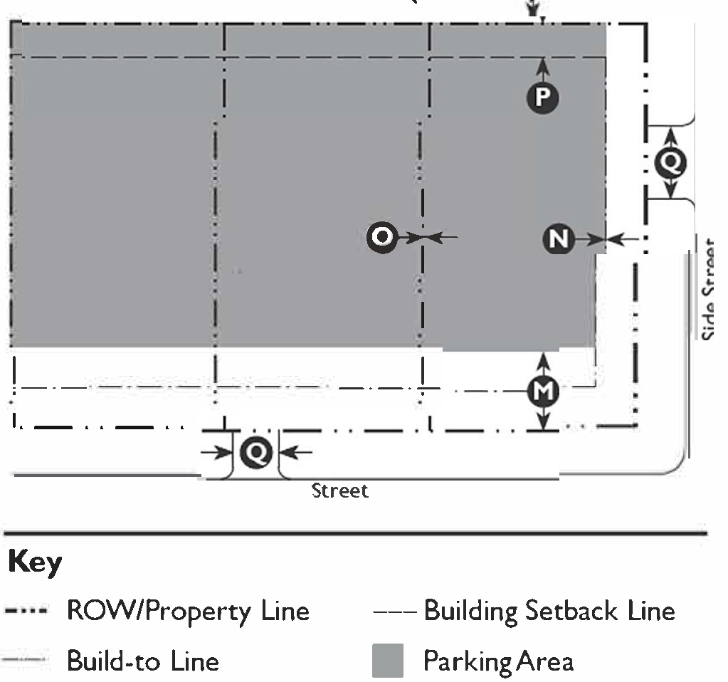
| Location (Distance from Property Line/ROW) | ||
| Front Setback | 5' min. 13 | |
| Side Street Setback | 0' min. from BTL | |
| Side Setback | 0' min. | |
| Rear Setback | ||
| Adjacent to T5N, T4N or T3N | 5' min. | |
| Adjacent to all other Transect Zones | 0' min. | |
| Adjacent to Alley | 0' | |
| Parking Access Drive | ||
| Width | 12' min. 14 | |
| Miscellaneous | ||
| All garages shall be screened from the front and the street by habitable space. | ||
| Footnotes: | ||
| 1. Where existing adjacent buildings are in front of the regulated BTL, the building may be set to align with the façade of the front most immediately adjacent property. | ||
| 2. The exact location of the BTL, within the range listed above shall be established by the first building along each block frontage to receive Planning Division approval. All subsequent buildings along that block frontage shall match the first building's BTL. | ||
| 3. Entire BTL shall be defined by a building or a 24" to 42" high hedge, fence or stucco or masonry wall, except for entry ways, driveways, and walkways. | ||
| 4. On corner lots, the BTL must be defined by a building for the first 30' from the corner. | ||
| 5. Only allowed in conjunction with Single-Unit House, Village; Single-Unit, Cottage, and Duplex Building Types. | ||
| 6. Five (5) stories maximum permitted for buildings with more than 25% affordable or senior housing or for LEED Gold (or equivalent) certified buildings. Within 20' of the rear property line, buildings may not be more than a half-story taller than the allowed height of adjacent buildings. | ||
| 7. A 14' ground floor ceiling height is required for both residential and commercial uses in Mid-rise and Main Street Mixed Use Building Types. | ||
| 8. Encroachments only allowed within the ROW and public alleys within the Downtown Pedestrian Area. Encroachments must have a minimum 14' clear height and approval of an encroachment permit. | ||
| 9. No parking spaces required for the first 2,000 sf of residential use, for affordable housing units, senior housing units, or Accessory Dwelling Units. | ||
| 10. No parking spaces required for ground floor, non-residential uses less than 5,000 sf. | ||
| 11. Shared parking may be used to meet parking requirements through a recorded parking agreement. | ||
| 12. Off-site parking within 1,200' may be used to meet parking requirements for non-residential uses. | ||
| 13. Parking must be placed at least five (5) feet behind the building's façade. | ||
| 14. Maximum parking access drive width to be determined by Solid Waste and Fire access requirements. | ||
(Ord. No. 5948, § 1, 7-1-25)
11-58-7: - T4 MAIN STREET (T4MS) STANDARDS
| A. Zone Intent and Description | ||
| To integrate vibrant main-street commercial and retail environments into neighborhoods, providing access to daily amenities within walking distance, creating opportunities for transit stops and serving as a focal point for the neighborhood. | ||
 | ||
| B. Building Types | ||
| Allowed Building Types: |
Main Street Mixed Use
Mid-Rise | See Chapter 59: Building Type Standards for descriptions and regulations |
| C. Building Placement | ||
 | ||
| Build-to Lines (Distance from Property Line/ROW) | ||
| Front | 0' max. | |
| Side Street | 0' max. | |
| Build-to Lines Defined by a Building | ||
| Front, Lots <50' wide | 100% | |
| Front, Lots ≥50' wide | 75% min. 1, 2 | |
| Side Street | 50% min. 1, 2 | |
| Building Façade at Front BTL | 100% | |
| Setbacks (Distance from Property Line/ROW) | ||
| Main Building | ||
| Side | 0' min. 3 | |
| Rear | ||
| Adjacent to T5N, T4N or T3N | 5' min. | |
| Adjacent to All Other Transect Zones | 0' min. | |
| Adjacent to Alley | 0' min. | |
| Accessory Dwelling Unit 4 | See Section 11-31-3: Accessory Dwelling Unit | |
| Miscellaneous | ||
| A building form with a chamfered corner is permitted only if a corner entry is provided. | ||
| D. Building Form | ||
 | ||
| Height | ||
| Main Building | 20' min.; 4 Stories max. 5, 6 | |
| Ground Floor Finish Level | 6" max. | |
| Ground Floor Ceiling | 14' min. clear | |
| Upper Floor (s) Ceiling | 9' min. | |
| Footprint | ||
| Per Building Type Standards (see Chapter 59). | ||
| Depth, Ground-Floor Space | ||
| Commercial, Front | 50' min. | |
| Commercial, Side Street | 15' min | |
| Distance Between Entries | ||
| Ground Floor | 50' max. | |
| Miscellaneous | ||
| Upper floors shall have a primary entrance along the front. | ||
| Loading docks, overhead doors, and other service entries may not be located on street-facing façades. | ||
| E. Encroachments | ||
 | ||
| Allowed Encroachments | ||
| Front | 14' max. 7 | |
| Side Street | 14' max. 7 | |
| Rear | 5' max. 7 | |
| Miscellaneous | ||
| See Chapter 60: Private Frontage Standards for additional encroachment standards specific to frontage types. | ||
| F. Private Frontage Types | ||
| Allowed Frontage Types |
Forecourt
Shopfront Gallery Arcade | See Chapter 60: Private Frontage Standards for private frontage type descriptions and regulations |
| G. Parking | ||
 | ||
| Required Spaces | ||
| Residential Uses | 1/1,000 sf min. 8, 9 | |
| Retail and Service Uses | 2/1,000 sf min. 9, 10, 11 | |
| Location (Distance from Property Line/ROW) | ||
| Front Setback | ||
| Ground Floor | 50' min. | |
| Upper Floors | 30' min. | |
| Side Street Setback | 0' min. | |
| Side Setback | 0' min. | |
| Rear Setback | ||
| Adjacent to T5N, T4N or T3N | 5' min. | |
| Adjacent to all other Transect Zones | 0' min. | |
| Adjacent to Alley | 0' min. | |
| Parking Access Drive | ||
| Width | 12' min. 12 | |
| Miscellaneous | ||
| All garages shall be screened from the front and the street by habitable space. | ||
| Footnotes: | ||
| 1. Entire BTL shall be defined by a building or a 24" to 42" high stucco or masonry wall, except for entryways, driveways, and walkways. | ||
| 2. On corner lots, the BTL must be defined by a building for the first 30' from the corner. | ||
| 3. No side setback required along the common property line between townhouse and/or duplex building types or for accessory structures when in conjunction with a townhouse or duplex building type. | ||
| 4. Only allowed in conjunction with the Duplex Building Type. | ||
| 5. Six (6) stories maximum permitted for buildings with more than 25% affordable or senior housing or for LEED Gold (or equivalent) certified buildings. | ||
| 6. Within 20' of the rear property line, buildings may not be more than a half-story taller than the allowed height of adjacent buildings. | ||
| 7. Encroachments only allowed within the ROW and public alleys within the Downtown Pedestrian Area. Encroachments must have a minimum 14' clear height and approval of an encroachment permit. | ||
| 8. No parking spaces required for the first 2,000 sf of residential use, for affordable housing units, senior housing units, or Accessory Dwelling Units. | ||
| 9. Shared parking may be used to meet parking requirements through a recorded parking agreement. | ||
| 10. No parking spaces required for ground floor, non-residential uses less than 5,000 sf. | ||
| 11. Off-site parking within 1,200' may be used to meet parking requirements for non-residential uses. | ||
| 12. Maximum parking access drive width to be determined by Solid Waste and Fire access requirements. | ||
(Ord. No. 5948, § 1, 7-1-25)
11-58-8: - T5 NEIGHBORHOOD (T5N) STANDARDS
| A. Zone Intent and Description | ||
| To provide a medium- to high-density residential building types such as apartment houses, courtyard buildings, and mid-rise buildings that transition from lower-density surrounding residential neighborhoods to the higher-density mixed-use neighborhoods. | ||
 | ||
| B. Building Types | ||
| Allowed Building Types |
Apartment House
Courtyard Building Bungalow Cour Mid-Rise | See Chapter 59: Building Type Standards for descriptions and regulations |
| C. Building Placement | ||
 | ||
| Build-to Lines (Distance from Property Line/ROW) | ||
| Front | 0' min.; 15' max. 1, 2 | |
| Side Street | 0' min.; 15' max. | |
| Build-to Lines Defined by a Building | ||
| Front | 60% min. 3, 4 | |
| Side Street | 60% min. 3, 4 | |
| Setbacks (Distance from Property Line/ROW) | ||
| Side | 0' min. | |
| Rear | ||
| Adjacent to T5N, T4N or T3N | 5' min. | |
| Adjacent to All Other Transect Zones | 0' min. | |
| Adjacent to Alley | 0' min. | |
| D. Building Form | ||
 | ||
| Height | ||
| Main Building | 2 Stories min.; 55' max. 5 | |
| Ground Floor Finish Level | ||
| Residential BTL/Setback <8' | 24" min. | |
| Residential BTL/Setback ≥8' | 18" min. | |
| Ground Floor Ceiling | 10' min. clear | |
| Upper Floor(s) Ceiling | 9' min. clear | |
| Footprint | ||
| Per Building Type Standards (see Chapter 59). | ||
| Depth, Ground-Floor Space | 20' min. | |
| Distance between Entries | ||
| Ground Floor | 50' max. | |
| Miscellaneous | ||
| Upper Floors shall have a primary entrance along the front. | ||
| Loading docks, overhead doors, and other service entries may not be located on street-facing façades. | ||
| E. Encroachments | ||
 | ||
| Allowed Encroachments | ||
| Front | 14' max. 6 | |
| Side Street | 14' max. 6 | |
| Rear | 5' max. 6 | |
| Miscellaneous | ||
| See Chapter 60: Private Frontage Standards for additional encroachment standards specific to frontage types. | ||
| F. Private Frontage Types | ||
| Allowed Frontage Types |
Stoop
Forecourt Dooryard | See Chapter 60: Private Frontage Standards for private frontage type descriptions and regulations |
| G. Parking | ||
 | ||
| Required Spaces | ||
| Residential Uses | No min.; 1/unit max. 7 | |
| Location (Distance from Property Line/ROW) | ||
| Front Setback | 30' min. | |
| Side Street Setback | 0' min. from BTL | |
| Side Setback | 0' min. | |
| Rear Setback | ||
| Adjacent to T4N or T3N | 5' min. | |
| Adjacent to all other Transect Zones | 0' min. | |
| Adjacent to Alley | 0' min. | |
| Parking Access Drive | ||
| Width | 12' min. 8 | |
| % of Frontage along Front | 20% max. | |
| Miscellaneous | ||
| All garages shall be screened from the front and the street by habitable space. | ||
| Footnotes: | ||
| 1. Where existing adjacent buildings are in front of the regulated BTL, the building may be set to align with the façade of the front most immediately adjacent property. | ||
| 2. The exact location of the BTL within the range listed above shall be established by the first building along each block frontage to receive planning department approval. All subsequent buildings along that block frontage shall match the first building's BTL. | ||
| 3. Entire BTL shall be defined by a building or a 24" to 42" high fence or stucco or masonry wall, except for entry ways, driveways, and walkways. | ||
| 4. On corner lots, the BTL must be defined by a building for the first 50' from the corner. | ||
| 5. Within 20' of the rear property line, buildings may not be more than a half-story taller than the allowed height of adjacent buildings. | ||
| 6. Encroachments only allowed within the ROW and public alleys within the Downtown Pedestrian Area. Encroachments must have a minimum 14' clear height and approval of an encroachment permit. | ||
| 7. Off-site parking within 600' may be used to meet parking requirements for residential uses. | ||
| 8. Maximum parking access drive width to be determined by Solid Waste and Fire access requirements. | ||
(Ord. No. 5948, § 1, 7-1-25)
11-58-9: - T5 MAIN STREET FLEX (T5MSF) STANDARDS
| A. Zone Intent and Description | ||
| To provide a flexible area that transitions from the commercial districts to residential districts by allowing for a mixture of ground floor uses, including live/work and ground floor residential that could transition to commercial space when the commercial corridor matures. | ||
 | ||
| B. Building Types | ||
| Allowed Building Types |
Apartment House
Courtyard Building Main Street Mixed-Use Mid-Rise | See Chapter 59: Building Type Standards for descriptions and regulations |
| C. Building Placement | ||
 | ||
| Build-to Lines (Distance from Property Line/ROW) | ||
| Front | 0' min.; 10' max. 1,2 | |
| Side Street | 0' min.; 10' max. | |
| Build-to Lines Defined by a Building 3 | ||
| Front, Lots <50' wide | 100% | |
| Front, Lots ≥50' wide | 75% min. 4 | |
| Side Street | 60% min. 4 | |
| Setbacks (Distance from Property Line/ROW) | ||
| Main Building | ||
| Side | 0' min. | |
| Rear | ||
| Adjacent to T5N, T4N or T3N | 5' min. | |
| Adjacent to All Other Transect Zones | 0' min. | |
| Adjacent to Alley | 0' min. | |
| Miscellaneous | ||
| A building form with a chamfered corner is permitted if a corner entry is provided. | ||
| D. Building Form | ||
 | ||
| Height | ||
| Main Building | 2 Stories min.; 75' max. 5, 6 | |
| Ground Floor Finish Level | ||
| Residential BTL/Setback <8' | 24" min. | |
| Residential BTL/Setback ≥8' | 18" min. | |
| Commercial | 6" max. | |
| Ground Floor Ceiling | ||
| Residential | 10' min. clear | |
| Commercial | 14' min. clear | |
| Upper Floor(s) Ceiling | 9' min. clear | |
| Footprint | ||
| Per Building Type Standards (see Chapter 59). | ||
| Depth, Ground-Floor Space | ||
| Residential | 20' min | |
| Commercial | 15' min. | |
| Distance Between Entries | ||
| To Ground Floor | 50' max. | |
| To Upper Floor(s) | 100' max. | |
| Miscellaneous | ||
| Upper floors shall have a primary entrance along the front. | ||
| Loading docks, overhead doors, and other service entries may not be located on street-facing façades. | ||
| E. Encroachments | ||
 | ||
| Allowed Encroachments | ||
| Front | 14' max. 7 | |
| Side Street | 14' max. 7 | |
| Rear | 5' max. 7 | |
| Miscellaneous | ||
| See Chapter 60: Private Frontage Standards for additional encroachment standards specific to frontage types. | ||
| F. Private Frontage Types | ||
| Allowed Frontage Types |
Stoop
Forecourt Dooryard Shopfront Terrace Gallery Arcade | See Chapter 60: Private Frontage Standards for private frontage type descriptions and regulations |
| G. Parking. | ||
 | ||
| Required Spaces | ||
| Residential Uses | No min.; 1/unit max. 8, 9 | |
| Retail and Service Uses | 2/1,000 sf min. 9, 10, 11 | |
| Location (Distance from Property Line/ROW) | ||
| Front Setback | 30' min. | |
| Side Street Setback | 0' min. (from BTL) | |
| Side Setback | 0' min. | |
| Rear Setback | ||
| Adjacent to T5N, T4N or T3N | 5' min. | |
| Adjacent to all other Transect Zones | 0' min. | |
| Adjacent to Alley | 0' min. | |
| Parking Access Drive | ||
| Width | 12 min. 12 | |
| % of Frontage along Front | 20% max. | |
| Miscellaneous | ||
| All garages shall be screened from the front and the street by habitable space. | ||
| Footnotes: | ||
| 1. Where existing adjacent buildings are in front of the regulated BTL, the building may be set to align with the façade of the front most immediately adjacent property. | ||
| 2. The exact location of the BTL within the range listed above shall be established by the first building along each block frontage to receive Planning Division approval. All subsequent buildings along that block frontage shall match the first building's BTL. | ||
| 3. Entire BTL shall be defined by a building or a 24" to 42" high stucco or masonry wall, except for entry ways, driveways, and walkways. | ||
| 4. On corner lots, the BTL must be defined by a building for the first 50' from the corner. | ||
| 5. 85' maximum permitted for buildings with more than 25% affordable or senior housing; 105' maximum for LEED Gold (or equivalent) certified buildings. | ||
| 6. Within 20' of the rear property line, buildings may not be more than a half-story taller than the allowed height of adjacent buildings. | ||
| 7. Encroachments only allowed within the ROW and public alleys within the Downtown Pedestrian Area. Encroachments must have a minimum 14' clear height and approval of an encroachment permit. | ||
| 8. Off-site parking within 600' may be used to meet parking requirements for residential uses. | ||
| 9. Shared parking may be used to meet parking requirements through a recorded parking agreement. | ||
| 10. No parking spaces are required for lodging uses and ground floor uses less than 5,000 sf. | ||
| 11. Off-site parking within 1,200' may be used to meet parking requirements for non-residential uses. | ||
| 12. Maximum parking access drive width to be determined by Solid Waste and Fire access requirements. | ||
(Ord. No. 5948, § 1, 7-1-25)
11-58-10: - T5 MAIN STREET (T5MS) STANDARDS
| A. Zone Intent and Description | ||
| To integrate medium-intensity, vertically mixed-uses that seemlessly transition into adjacent neighborhoods in central Mesa, near transit stops, or other pedestrian-oriented urban area areas. | ||
 | ||
| B. Building Types | ||
| Allowed Building Types |
Main Street Mixed-Use
Mid-Rise High-Rise | See Chapter 59: Building Type Standards for descriptions and regulations |
| C. Building Placement | ||
 | ||
| Build-to Lines (Distance from Property Line/ROW) | ||
| Front | 0' max. | |
| Side Street | 0' max. | |
| Build-to Lines Defined by a Building Front | ||
| Front | 100% 1 | |
| Side Street | 60% min. 1, 2 | |
| Setbacks (Distance from Property Line/ROW) | ||
| Main Building | ||
| Side | 0' min. | |
| Rear | 0' min. | |
| Lot Size | ||
| Width | 50' min. 3 | |
| Miscellaneous | ||
| A building form with a chamfered corner is permitted if a corner entry is provided. | ||
| D. Building Form | ||
 | ||
| Height | ||
| Main Building |
4 Stories min.;
105' max. 3, 4 | |
| Ground Floor Finish Level | 6" max. | |
| Ground Floor Ceiling | 14' min. clear | |
| Upper Floor (s) Ceiling | 9' min. clear | |
| Footprint | ||
| Per Building Type Standards (see Chapter 59). | ||
| Depth, Ground-Floor Space | ||
| Front | 50' min. | |
| Side Street | 15' min. | |
| Distance Between Entries | ||
| Ground Floor | 50' max. | |
| Miscellaneous | ||
| Upper Floors shall have a primary entrance along the front. | ||
| Loading docks, overhead doors, and other service entries may not be located on street-facing façades | ||
| E. Encroachments | ||
 | ||
| Allowed Encroachments | ||
| Front | 14' max. 5 | |
| Side Street | 14' max. 5 | |
| Rear | 14' max. 5 | |
| Miscellaneous | ||
| See Chapter 60: Private Frontage Standards for additional encroachment standards specific to frontage types. | ||
| F. Private Frontage Types | ||
| Allowed Frontage Types |
Stoop
Forecourt Dooryard Shopfront Terrace Gallery Arcade | See Chapter 60: Private Frontage Standards for private frontage type descriptions and regulations |
| G. Parking | ||
 | ||
| Required Spaces | ||
| Residential Uses | No min.; 1/unit max. 6, 7 | |
| Retail and Service Uses | 2/1,000 sf min. 7, 8, 9 | |
| Location (Distance from Property Line/ROW) | ||
| Front Setback | ||
| Ground Floor | 50' min. | |
| Upper Floors | 15' min. 10 | |
| Side Street Setback | ||
| Ground Floor | 15' min. | |
| Upper Floors | 0' min. 10 | |
| Side Setback | 0' min. | |
| Rear Setback | 0' min. | |
| Parking Access Drive | ||
| Width | 12' min. 11 | |
| % of Frontage along Front | 20% max. | |
| Miscellaneous | ||
| All garages shall be screened from the front and the street by habitable space. | ||
| Footnotes: | ||
| 1. Entire BTL shall be defined by a building or a 24" to 36" high stucco or masonry wall, except for entry ways, driveways, and walkways. | ||
| 2. On corner lots, the BTL must be defined by a building for the first 50' from the corner. | ||
| 3. Two (2) stories minimum permitted in the Historic Downtown Overlay (See Regulating Plan); 135' maximum permitted for buildings with more than 25% affordable or senior housing; 155 maximum for LEED Gold (or equivalent) certified buildings. | ||
| 4. Within 20' of the rear property line, buildings may not be more than a half-story taller than the allowed height of adjacent buildings. | ||
| 5. Encroachments only allowed within the ROW and public alleys within the Downtown Pedestrian Area. Encroachments must have a minimum 14' clear height and approval of an encroachment permit. | ||
| 6. Off-site parking within 600' may be used to meet parking requirements for residential uses. | ||
| 7. Shared parking may be used to meet parking requirements through a recorded parking agreement. | ||
| 8. No parking spaces required for lodging uses and ground floor uses less than 5,000 sf. | ||
| 9. Off-site parking within 1,200' may be used to meet parking requirements for non-residential uses. | ||
| 10. Parking located above the ground floor may occupy the entire floor space and is not required to be set back. | ||
| 11. Maximum parking access drive width to be determined by Solid Waste and Fire access requirements. | ||
(Ord. No. 5948, § 1, 7-1-25)
11-58-11: - T6 MAIN STREET (T6MS) STANDARDS
| A. Zone Intent and Description | ||
| To enable designated areas within the core of central Mesa to evolve into higher-intensity mixed-use development that can support transit and foster a vibrant urban environment. | ||
 | ||
| B. Building Types | ||
| Allowed Building Types |
Main Street Mixed-Use
Mid-Rise High-Rise | See Chapter 59: Building Type Standards for descriptions and regulations |
| C. Building Placement | ||
 | ||
| Build-to Lines (Distance from Property Line/ROW) | ||
| Front | 0' max. | |
| Side Street | 0' max. | |
| Build-to Lines Defined by a Building | ||
| Front | 100% | |
| Side Street | 80% min. 1 | |
| Setbacks (Distance from Property Line/ROW) | ||
| Side | 0' min. | |
| Rear | 0' min. | |
| Lot Size | ||
| Width | 50' min. | |
| D. Building Form | ||
 | ||
| Height | ||
| Main Building | 4 Stories min.; 135' max. 2 | |
| Ground Floor Finish Level | 6" max. | |
| Ground Floor Ceiling | 14' min. clear | |
| Upper Floor(s) Ceiling | 9' min. clear | |
| Footprint | ||
| Per Building Type Standards (see Chapter 59). | ||
| Depth, Ground-Floor Space | 50' min. | |
| Distance Between Entries | ||
| Ground Floor | 50' max. | |
| Miscellaneous | ||
| Upper floors shall have a primary entrance along the front. | ||
| Loading docks, overhead doors, and other service entries may not be located on street-facing façades. | ||
| E. Encroachments | ||
 | ||
| Allowed Encroachments | ||
| Front | 14' max. 3 | |
| Side Street | 14' max. 3 | |
| Rear | 0' max. 3 | |
| Miscellaneous | ||
| See Chapter 60: Private Frontage Standards for additional encroachment standards specific to frontage types. | ||
| F. Private Frontage Types | ||
| Allowed Frontage Types |
Shopfront
Terrace Gallery Arcade | See Chapter 60: Private Frontage Standards for private frontage type descriptions and regulations |
| G. Parking. | ||
 | ||
| Required Spaces | ||
| Residential Uses | No min.; 1/unit max. 4, 5 | |
| Retail and Service Uses | 2/1,000 sf min. 5, 6, 7 | |
| Location (Distance from Property Line/ROW) | ||
| Front Setback | ||
| Ground Floor | 50' min. | |
| Upper Floors | 30' min. | |
| Side Street Setback | ||
| Ground Floor | 30' min. | |
| Upper Floors | 0' min. | |
| Side Setback | 0' min. | |
| Rear Setback | 0' min. | |
| Parking Access Drive | ||
| Width | 12' min. 8 | |
| % of Frontage along Front | 20% max. | |
| Footnotes: | ||
| 1. On corner lots, the BTL must be defined by a building for the first 50' from the corner. | ||
| 2. 155' maximum for buildings with more than 25% affordable or senior housing. No maximum for LEED (or equivalent) certified buildings. | ||
| 3. Encroachments only allowed within the ROW and public alleys within the Downtown Pedestrian Area. Encroachments must have a minimum 14' clear height and approval of an encroachment permit. | ||
| 4. Off-site parking within 600' may be used to meet parking requirements for residential uses. | ||
| 5. Shared parking may be used to meet parking requirements through a recorded parking agreement. | ||
| 6. Off-site parking within 1,200' may be used to meet parking requirements for non-residential uses. | ||
| 7. No parking spaces required for ground floor uses less than 5,000 sf. | ||
| 8. Maximum parking access drive width to be determined by Solid Waste and Fire access requirements. | ||
(Ord. No. 5948, § 1, 7-1-25)
11-58-12: - ADDITIONAL STANDARDS FOR ALL TRANSECT ZONES
A.
Open Space Standards for All Transect Zones. The Civic Space Standards set forth in Chapter 62: Civic Space Standards provide the regulations for civic and open space within the FBC Transect Zones.
B.
Landscape Standards.
1.
See Chapter 33: Landscaping for landscaping standards on private lots within the FBC Transect Zones.
2.
Unbuilt areas on private lots, such as front yards and rear yards, should remain pervious and be landscaped in order to encourage soft edges and transitions between the public and private realms, reduce the heat island effect, and aid in compliance with the stormwater quality standards, to the maximum extent possible.
3.
Landscape treatments shall be limited to low-water-use plants, including those drought-tolerant plants listed by the Arizona Department of Water Resources for the Phoenix Active Management Area.
C.
Lighting Standards.
1.
All lighting shall comply with the standards found in the Mesa Lighting and Electrical Code, Title 4, Chapter 4 of the Mesa City Code.
2.
All lighting shall comply with Section 11-30-5 of this Zoning Code.
3.
All Outdoor lighting for sport courts/fields requires a Special Use Permit (SUP).
D.
Parking Requirements.
1.
Vehicle Parking. On-street parking spaces adjacent to the lot or parcel may be counted toward the minimum required off-street parking, subject to the following conditions:
a.
Only legal, parallel or angled head-in parking spaces along the lot frontage may be counted.
b.
The space must be located entirely along the frontage of the subject property.
c.
Spaces shall not be located within 30 feet of an intersection or 25 feet of a driveway.
d.
Spaces must remain public parking spaces and may not be designated for the development.
2.
Bicycle Parking.
a.
Required Spaces. Bicycle parking shall be provided at a minimum ratio of one (1) bicycle space for every 10 vehicular spaces with a maximum requirement of 20 bicycle spaces.
b.
Design and Location. Required bicycle parking spaces must:
i.
Be located in close proximity to entrances and other high activity areas that are highly visible, active, and well-lighted, without interfering with pedestrian movements or located within a building.
ii.
Consist of anchored racks or lockers that cannot be easily removed, be of solid construction, and be resistant to rust, corrosion, hammers, and saws.
iii.
Be designed so as not to cause damage to the bicycle.
iv.
Allow both the bicycle frame and the wheels to be locked using a standard U-lock.
v.
Maintain a separation of at least 24 inches from the nearest wall.
c.
Credit. For every 10 publicly accessible bicycle parking spaces provided, the required commercial parking spaces may be reduced by one (1) space with a maximum reduction of 15% of the required vehicular parking spaces.
E.
Parking Space Design.
1.
All parking spaces must be accessible from a public right-of-way.
2.
Except for designated accessible parking spaces, no parking spaces shall be required to be individually accessible.
3.
Tandem, stacking, and valet parking may be used to meet parking requirements.
4.
Parking spaces may be directly accessed from an accessible alley.
5.
On lots adjacent to an alley, all drives shall be accessed only from the alley.
6.
On corner lots, all drives shall be accessed only from the alley or side street.
7.
Shared drives are encouraged between adjacent lots to minimize curb cuts along the street.
8.
Off-street parking spaces do not have to be covered.
9.
Vehicles parked off-street may not encroach on a sidewalk.
10.
Underground parking may be placed up to the right-of-way or property line.
11.
Underground parking shall not be visible to pedestrians from a public way.
12.
Parking spaces shall be designed according to the dimensions in Section 11-32-2(H): Size of Parking Spaces and Maneuvering Aisles.
13.
If park-lifts or mechanically-ventilated garages are used next to residential uses, the noise and vibration of the mechanical systems shall be mitigated.
14.
All surface parking areas along a street or civic space that are not behind buildings shall be screened by a 3'6" tall minimum hedge, fence, or wall in character with the building at the ROW.
15.
All exposed structured parking shall be architecturally incorporated into the façade composition.
16.
On corner lots less than 100 feet wide, a maximum length of 60 feet of parking podium or garage is allowed along a side street.
17.
The minimum number of parking spaces required for buildings within ¼ mile of transit stop or transit station may be reduced by 20%.
18.
Temporary parking lots that will be replaced by a permanent building or structure are not subject to the parking location regulations in the Building Form Standards, but shall comply with all landscaping requirements.
19.
At least 10% of the area of an off-street parking with more than 30 spaces shall be reserved for landscaping.
19.
All off-street parking lots with 10 or more surface parking spaces shall meet the landscaping requirements of Section 11-33-4: Interior Parking Lot Landscaping.
(Ord. No. 5948, § 1, 7-1-25)
11-59-1: - PURPOSE
This Chapter outlines the development standards for Building Types and supplement the regulations for each permitted Transect Zone and the City of Mesa's Quality Development Design Guidelines. The names of the Building Types do not limit uses within a building. For example, a single-unit house may have non-residential uses within it, such as a cafe or an office.
(Ord. No. 5948, § 1, 7-1-25)
11-59-2: - APPLICABILITY
The standards within this Chater shall apply to all proposed development within Transect Zones and shall be considered along with the standards for the applicable Transect Zone in Chapter 58: Building Form Standards and Chapter 60: Private Frontage Standards.
(Ord. No. 5948, § 1, 7-1-25)
11-59-3: - CARRIAGE HOUSE
| A. Description | ||
| Carriage House: A secondary structure, typically located at the rear of a lot, which provides habitable or occupiable space for an Accessory Dwelling Unit, detached garage, storage, home office, or small commercial/service use. Carriage houses play an important role in supporting affordable housing and nurturing small businesses in walkable neighborhoods, contributing to both community livability and economic vitality. | ||
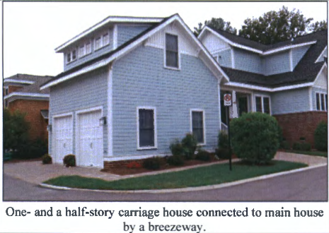 | 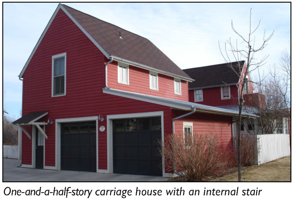 | |
| (All photos are illustrative, not regulatory) | ||
| B. Permitted Transects. | ||
 | ||
| C. Lot Requirements. | ||
| Allowed on lots when accompanying the following building types: Single-Unit House, Village; Single-Unit House, Cottage; Duplex, Townhouse; and Mansion Apartment | ||
| D. Number of Units. | ||
| Accessory Structure | 1 max. | |
| Accessory Dwelling Unit | See Section 11-31-3: Accessory Dwelling Unit | |
| E. Building Size, massing, and height | ||
 | ||
| Main Body | ||
| Height | See Chapter 58: Building Form Standards | |
| Width | 36' max. 1, 2 | |
| Depth | 30' max. 1, 2 | |
| Separation from main building | 6' min. 3 | |
| F. Frontage Requirements. | ||
| Allowed Private Frontages 4 | Stoop | See Chapter 60: Private Frontage Standards for private frontage type descriptions and regulations |
| Entrance Locations | Side street, alley, or internal to the lot 5 | |
| G. Vehicle Access and Parking. | ||
| Parking may be accessed from the alley, side street, or front. | ||
| Parking may be accessed from the front only when there is no adjacent alley or side street. | ||
| All parking spaces provided shall be separate from the principal building and may be enclosed, covered, or open. | ||
| H. Private Open Space. | ||
| The private open space requirements shall be determined by the main building on the lot. | ||
| No additional private open space is required for a Carriage House. | ||
| Footnotes: | ||
| 1. Carriage Houses shall not have a larger footprint than the main building on the lot. | ||
| 2. Standards do not apply to Accessory Dwelling Units. | ||
| 3. Carriage House may be connected to the main building by uninhabitable space such as a breezeway. | ||
| 4. Carriage Houses are not required to have a Frontage Type. | ||
| 5. The main entrance may not be through a garage. | ||
(Ord. No. 5948, § 1, 7-1-25)
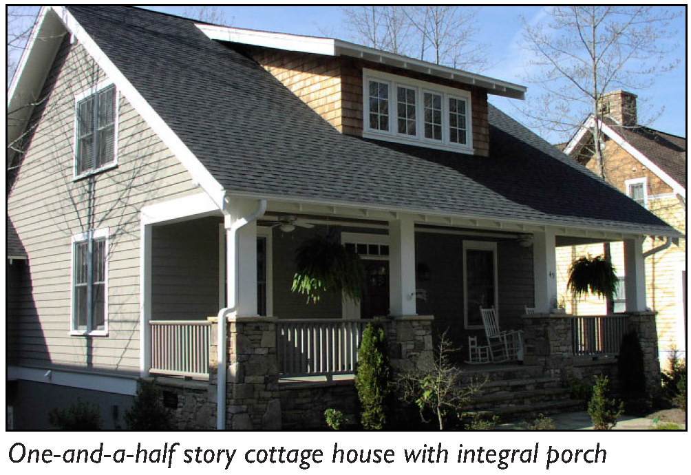
11-59-4: - SINGLE-UNIT HOUSE, VILLAGE
| A. Description | ||
| Single-Unit House, Village: This Building Type is a medium-sized detached structure on a medium-sized lot that incorporates one (1) unit. It is typically located within a primarily single residence residential neighborhood in a walkable urban setting, potentially near a neighborhood main street. | ||
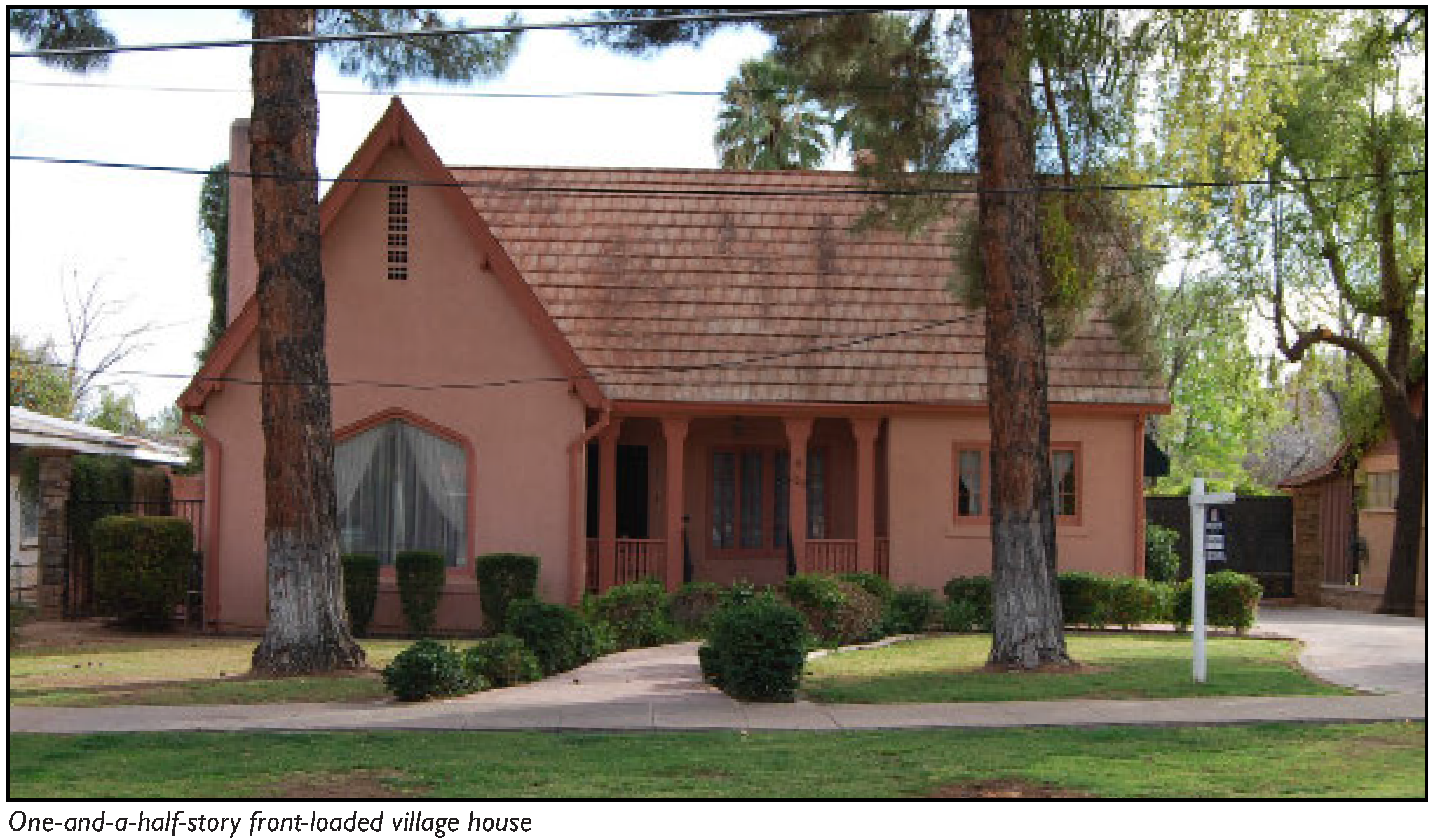 | ||
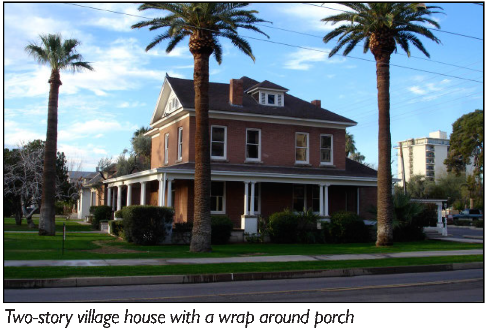 | 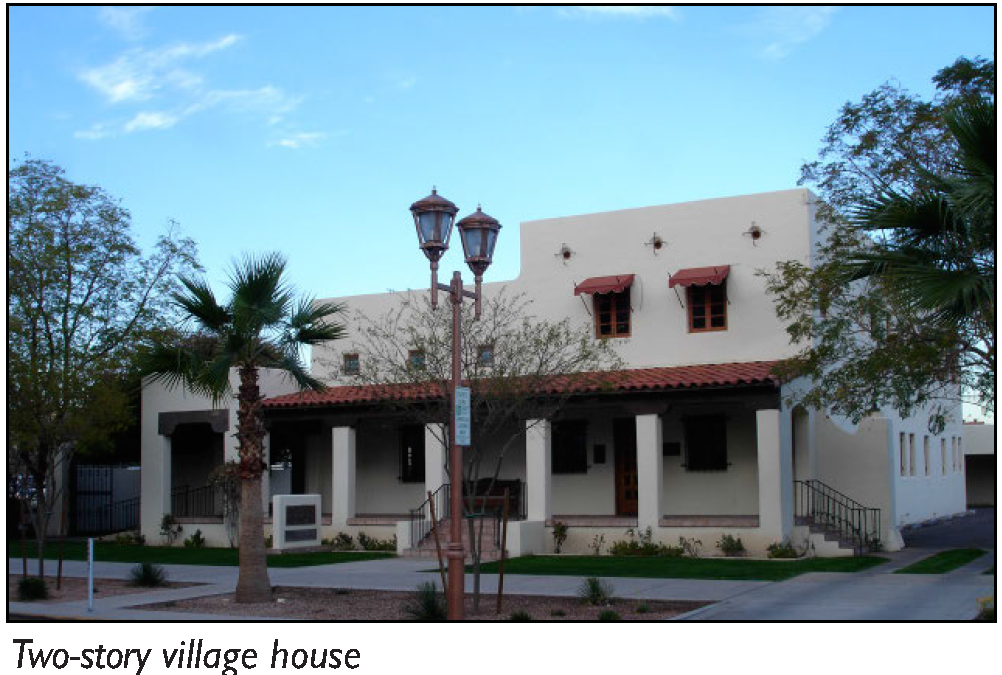 | |
| (All photos are illustrative, not regulatory) | ||
| B. Permitted Transects. | ||
 | ||
| C. Number of Units. | ||
| Single-Unit House, Village | 1 max. | |
| Accessory Dwelling Unit | See Section 11-31-3: Accessory Dwelling Unit | |
| D. Building Size and Massing | ||
 | ||
| Main Body | ||
| Height | See Chapter 58: Building Form Standards | |
| Width | 48' max. 1 | |
| Secondary Wing(s) | ||
| Width | 30' max. 1 | |
| Depth | 30' max. 1 | |
| Accessory Structure(s) | ||
| Width | 24' max. 1 | |
| Depth | 30' max. 1 | |
| E. Frontages | ||
 | ||
| Allowed Private Frontages |
Porch, Engaged
Porch, Projecting | See Chapter 60: Private Frontage Standards for private frontage type descriptions and regulations. |
| Entrance Locations | Front | |
| F. Vehicle Access and Parking. | ||
| Parking may be accessed from the alley, side street or front. | ||
| Parking may be accessed from the front only when there is no adjacent alley or side street. | ||
| Parking spaces may be enclosed, covered or open. | ||
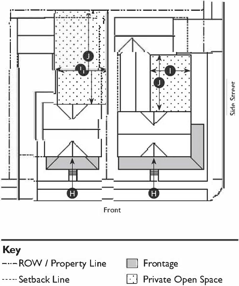
| G. Private Open Space | ||
| Width | 20' min. | |
| Depth | 20' min. | |
| Area | 500 sf min. 2 | |
| Footnotes: | ||
| 1. Standards do not apply to Accessory Dwelling Units. | ||
| 2. Required street setbacks and driveways shall not be included in the private open space area calculation. | ||
(Ord. No. 5948, § 1, 7-1-25)
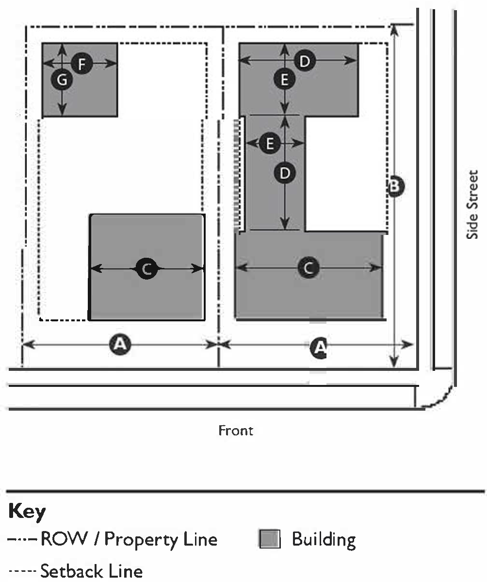
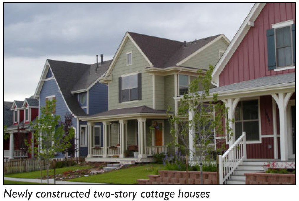
11-59-5: - SINGLE-UNIT HOUSE, COTTAGE
| A. Description | ||
| Single-Unit House, Cottage: This Building Type is a small detached structure on a small lot that incorporates one (1) unit. It is typically located within a primarily single residence neighborhood in a walkable urban setting, potentially near a neighborhood main street. This Building Type enables appropriately-scaled, well-designed higher densities and is important for providing a broad choice of housing types and promoting walkability. | ||
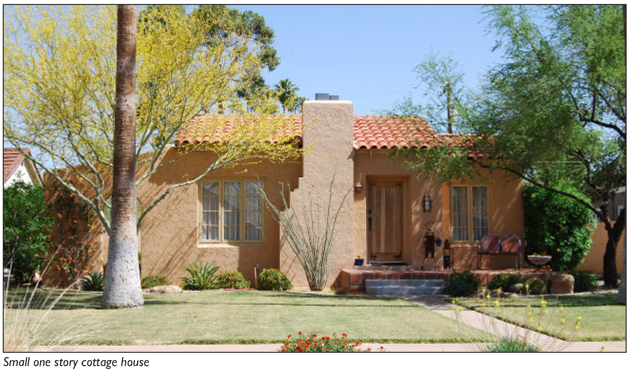 | ||
 |  | |
| (All photos are illustrative, not regulatory) | ||
| B. Permitted Transects | ||
 | ||
| C. Number of Units | ||
| Single-based Unit House, Cottage | 1 max. | |
| Accessory Dwelling Unit | See Section 11-31-3: Accessory Dwelling Unit | |
| Accessory Structure | 1 max. | |
| D. Building Size, Massing, and Height | ||
 | ||
| Main Body | ||
| Height | See Chapter 58: Building Form Standards | |
| Width | 36' max. | |
| Secondary Wing(s) | ||
| Width | 30' max. | |
| Depth | 30' max. | |
| Accessory Structure | ||
| Width | 24' max. 1 | |
| Depth | 30' max. 1 | |
| E. Frontage Requirements | ||
 | ||
| Allowed Private Frontages |
Stoop
Porch, Projecting | See Chapter 60: Private Frontage Standards for private frontage type descriptions and regulations. |
| Entrance Locations | Front | |
| F. Vehicle Access and Parking | ||
| Parking shall be accessed from a side street or alley. | ||
| Parking spaces may be enclosed, covered or open. | ||
| G. Private Open Space | ||
| Width | 15' min. | |
| Depth | 15' min. | |
| Area | 300 sf min. 2 | |
| Footnotes: | ||
| 1. Standards do not apply to Accessory Dwelling Units. | ||
| 2. Required street setbacks and driveways shall not be included in the private open space area calculation. | ||
(Ord. No. 5948, § 1, 7-1-25)
11-59-6: - BUNGALOW COURT
| A. Description | |||
| Bungalow Court: This Building Type consists of a series of small, detached structures, which provide multiple units arranged to define a shared court that is typically perpendicular to the street and defined on three (3) sides by buildings. The shared court takes the place of a private rear and becomes an important community-enhancing element of this Building Type. A Bungalow Court is appropriately scaled to fit within primarily single residence or medium-density neighborhoods. It enables appropriately scaled, well-designed higher densities and is important for providing a broad choice of housing types and promoting walkability. | |||
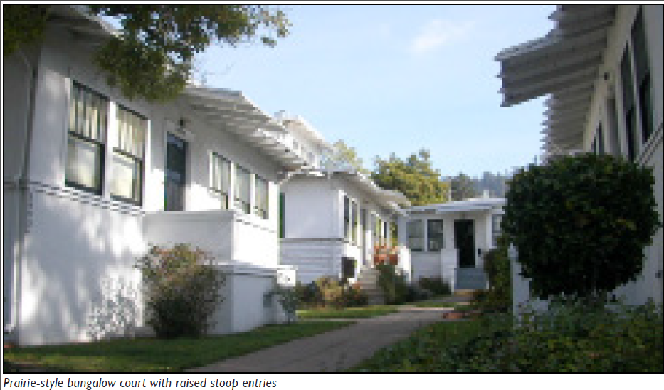 | |||
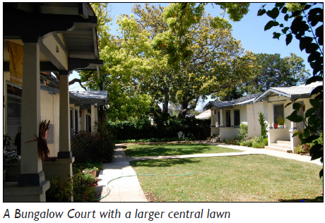 | 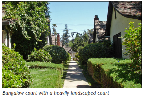 | ||
| (All photos are illustrative, not regulatory) | |||
| B. Permitted Transects | |||
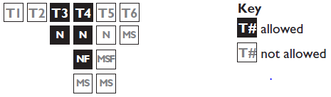 | |||
| C. Number of Units | |||
| Units | 3 min.; 9 max. | ||
| D. Building Size, Massing, and Height | |||
 | |||
| Main Body | |||
| Height | 1½ stories max. | ||
| Width | 32' max. | ||
| Depth | 24' max. | ||
| Secondary Wing(s) | |||
| Width | 24' max. | ||
| Depth | 12' max. | ||
| Accessory Structure | |||
| Width | 24' max. 1 | ||
| Depth | 24' max. 1 | ||
| E. Frontage Requirements | |||
 | |||
| Allowed Private Frontages |
Porch, Projecting
Stoop | See Chapter 60: Private Frontage Standards for private frontage type descriptions and regulations | |
| Entrance Locations | Front | ||
| F. Vehicle Access and Parking | |||
| Parking shall be accessed from the alley, side street or front. | |||
| Parking spaces may be accessed from the front only when there is no adjacent alley or side street. | |||
| Parking spaces may be enclosed, covered, or open. | |||
| G. Private Open Space | |||
| Width | 20' min. | ||
| Depth | 20' min. | ||
| Area | 400 sf min. 2 | ||
| Footnotes: | |||
| 1. Standards do not apply to Accessory Dwelling Units. | |||
| 2. Required street setbacks and driveways shall not be included in the private open space area calculation. | |||
(Ord. No. 5948, § 1, 7-1-25)
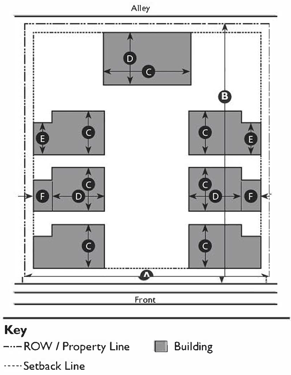
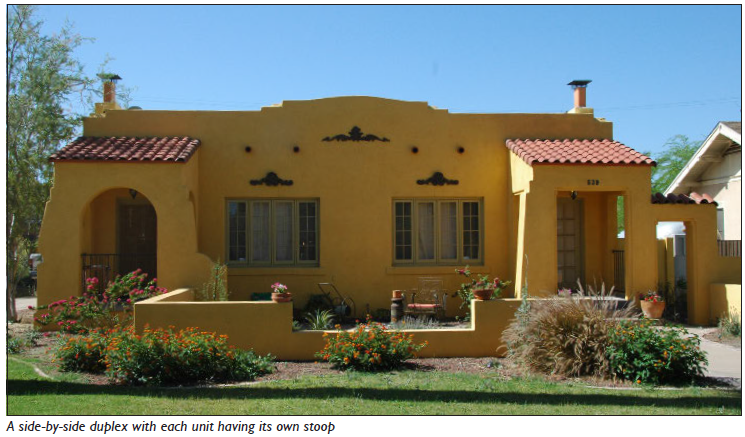
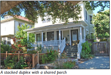
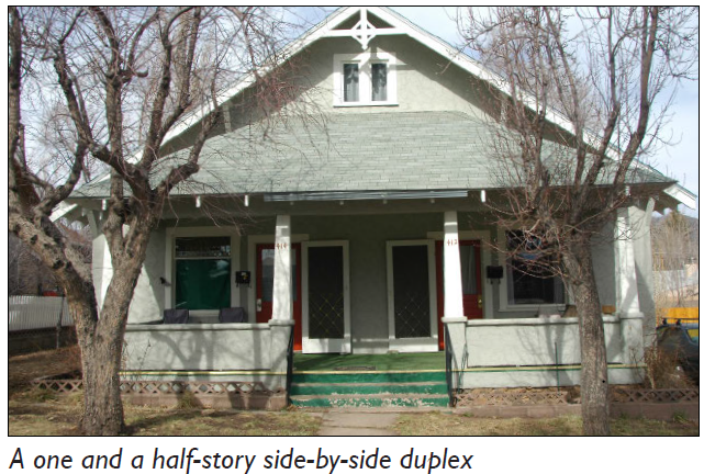
11-59-7: - DUPLEX
| A. Description | |||
| Duplex: This Building Type is a small-to-medium-sized structure that consists of two (2) side-by-side or stacked dwelling units, both facing the street, and sharing one (1) common party wall. A Duplex has the appearance of a medium to large single residence home and is appropriately scaled to fit within primarily single residence neighborhoods or medium-density neighborhoods. It enables appropriately-scaled, well-designed higher densities and is important for providing a broad choice of housing types and promoting walkability. | |||
 | |||
 |  | ||
| (All photos are illustrative, not regulatory) | |||
| B. Permitted Transects | |||
 | |||
| C. Number of Units | |||
| Duplex | 2 max. | ||
| Accessory Dwelling Unit | See Section 11-31-3: Accessory Dwelling Unit | ||
| D. Building Size, Massing, and Height | |||
 | |||
| Main Body | |||
| Height | See Chapter 58: Building Form Standards | ||
| Width | 48' max. | ||
| Secondary Wing(s) | |||
| Width | 30' max. | ||
| Accessory Structure(s) | |||
| Width | |||
| Individual unit ownership | 24' max. 2 | ||
| Shared between units | 48' max. 2 | ||
| Depth | 30' max. 2 | ||
| E. Frontage Requirements. | |||
 | |||
| Allowed Private Frontages |
Porch, Engaged
Porch, Projecting Stoop | See Chapter 60: Private Frontage Standards for private frontage type descriptions and regulations | |
| Entrance Locations | Front 3, 4 | ||
| F. Vehicle Access and Parking | |||
| Parking shall be accessed from the alley, side street or front. | |||
| Parking may be accessed from the front only when there is no adjacent alley or side street. | |||
| Parking spaces may be enclosed, covered, or open. | |||
| G. Private Open Space | |||
| Width | 15' per unit min. | ||
| Depth | 15' per unit min. | ||
| Area | 300 sf min. 5 | ||
| Footnotes: | |||
| 1. Total width of lot(s) if there is a shared property line. | |||
| 2. Standards do not apply to Accessory Dwelling Units. | |||
| 3. On corner lots, each unit shall front a different street. | |||
| 4. Each unit shall have an individual entry facing the street on or no more than 10' behind the front façade. | |||
| 5. Required street setbacks and driveways shall not be included in the private open space area calculation. | |||
(Ord. No. 5948, § 1, 7-1-25)
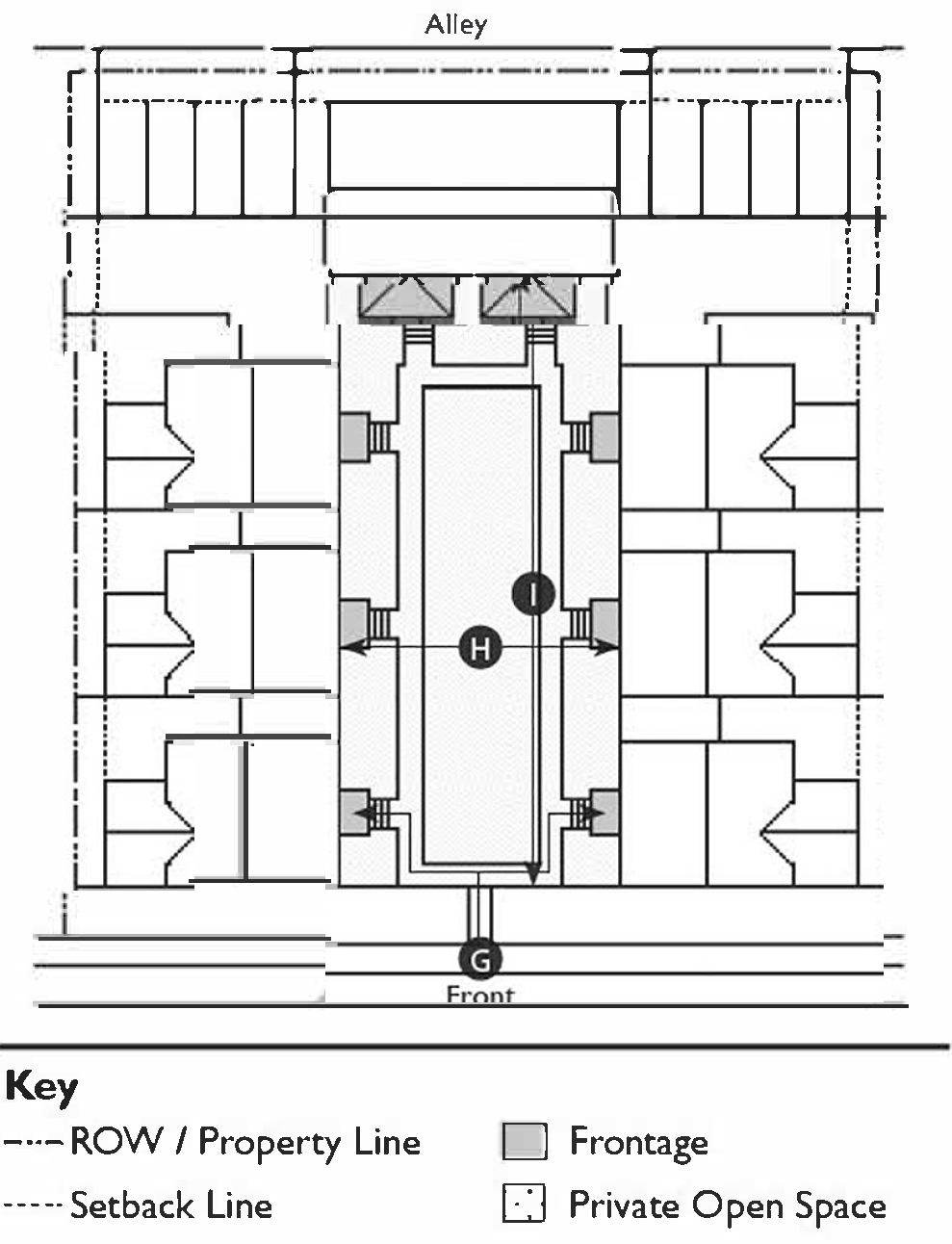
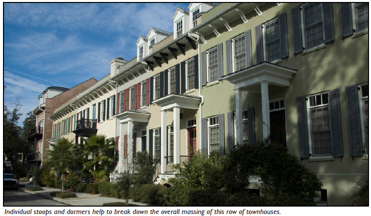
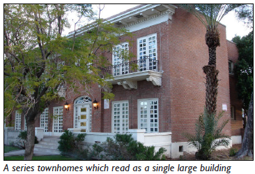
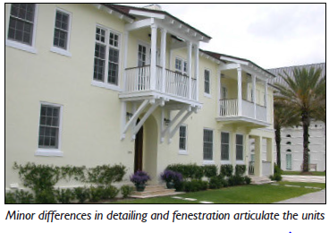
11-59-8: - TOWNHOUSE
| A. Description | |||
| Townhouse: This Building Type is a small-to-medium-sized attached structure that consists of one (1) or three (3) or more dwelling units placed side-by-side. A Townhouse is typically located within medium-density neighborhoods or in a location that transitions from a primarily single residence neighborhood into a neighborhood main street. This type enables appropriately-scaled, well-designed higher densities and is important for providing a broad choice of housing types and promoting walkability. Syn: Rowhouse | |||
 | |||
 |  | ||
| (All photos are illustrative, not regulatory) | |||
| B. Permitted Transects | |||
 | |||
| C. Number of Units | |||
| Units | 3 min.; 8 max. | ||
| Accessory Dwelling Unit | See Section 11-31-3: Accessory Dwelling Unit | ||
| D. Building Size, Massing, and Height | |||
 | |||
| Main Body | |||
| Height | See Chapter 58: Building Form Standards | ||
| Width | 18' min.; 36' max. | ||
| Secondary Wing(s) | |||
| The footprint area of the secondary wing(s) may not exceed the footprint area of the main body. | |||
| Width | 24' max. 1 | ||
| Depth | 30' max. 1 | ||
| Miscellaneous | |||
| The footprint area of an accessory structure may not exceed the footprint area of the main body. | |||
| E. Frontage Requirements | |||
 | |||
| Allowed Private Frontages |
Porch
Dooryard Stoop | See Chapter 60: Private Frontage Standards for private frontage type descriptions and regulations | |
| Entrance Locations | Front 2 | ||
| F. Vehicle Access and Parking | |||
| Parking shall be accessed from the alley, side street or front. | |||
| Parking may be accessed from the front only when there is no adjacent alley or side street. | |||
| When accessed from the front, a single shared drive shall be used. | |||
| Parking spaces may be enclosed, covered, or open. | |||
| G. Private Open Space | |||
| Width | 8' min. | ||
| Depth | 8' min. | ||
| Area | 100 sf min. 3 | ||
| Footnotes: | |||
| 1. Standards do not apply to Accessory Dwelling Units. | |||
| 2. Each unit shall have an individual entry facing a street. | |||
| 3. Required street setbacks and driveways shall not be included in the private open space area calculation. | |||
(Ord. No. 5948, § 1, 7-1-25)
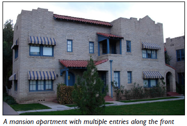
11-59-9: - MANSION APARTMENT
| A. Description | ||
| Mansion Apartment: This Building Type is a medium structure that consists of three (3) to six (6) side-by-side and/or stacked dwelling units, typically with one (1) shared entry or individual entries along the front. A Mansion Apartment has the appearance of a medium-sized single residence home and is appropriately scaled to fit in sparingly within primarily single residence neighborhoods or into medium-density neighborhoods. This Building Type enables appropriately-scaled, well-designed higher densities and is important for providing a broad choice of housing types and promoting walkability. | ||
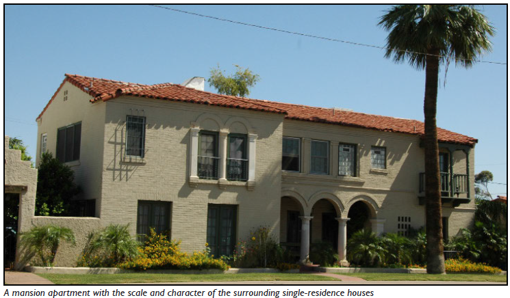 | ||
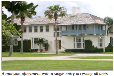 |  | |
| (All photos are illustrative, not regulatory) | ||
| B. Permitted Transects | ||
 | ||
| C. Number of Units | ||
| Units | 3 min.; 6 max. | |
| D. Building Size and Massing | ||
 | ||
| Main Body | ||
| Height | See Chapter 58: Building Form Standards | |
| Width | 48' max. | |
| Depth | 36' max. | |
| Secondary Wing(s) | ||
| Width | 30' max. | |
| Depth | 30' max. | |
| Accessory Structure(s) | ||
| Width | 48' max. 1, 2 | |
| Depth | 30' max. 1, 2 | |
| E. Frontage Requirements. | ||
 | ||
| Allowed Private Frontages |
Porch, Engaged
Porch, Projecting Stoop Dooryard | See Chapter 60: Private Frontage Standards for private frontage type descriptions and regulations |
| Entrance Locations | Front 3 | |
| F. Vehicle Access and Parking | ||
| Parking shall be accessed from the alley, side street or front. | ||
| Parking may be accessed from the front only when there is no adjacent alley or side street. | ||
| Parking spaces may be enclosed, covered, or open. | ||
| G. Private Open Space | ||
| Width | 8' min. | |
| Depth | 8' min. | |
| Area | 100 sf min. 4 | |
| Footnotes: | ||
| 1. Standards do not apply to Accessory Dwelling Units. | ||
| 2. The footprint area of an accessory structure may not exceed the footprint area of the main body. | ||
| 3. Each unit shall have an individual entry. | ||
| 4. Required street setbacks and driveways shall not be included in the private open space area calculation. | ||
(Ord. No. 5948, § 1, 7-1-25)
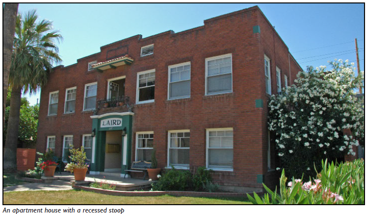
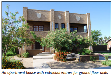
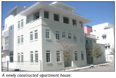
11-59-10: - APARTMENT HOUSE
| A. Description | ||
| Apartment House: This Building Type is a medium-to-large-sized structure that consists of seven (7) to 12 side-by-side and/or stacked dwelling units, typically with one (1) shared entry. An Apartment House is appropriately scaled to fit in within medium-density neighborhoods or sparingly within large lot predominantly single residence neighborhoods. This Building Type enables appropriately-scaled, well-designed higher densities and is important for providing a broad choice of housing types and promoting walkability. | ||
 | ||
 |  | |
| (All photos are illustrative, not regulatory) | ||
| B. Permitted Transects | ||
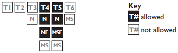 | ||
| C. Number of Units | ||
| Units | 7 min.; 12 max. | |
| D. Building Size, Massing, and Height | ||
 | ||
| Main Body | ||
| Height | See Chapter 58: Building Form Standards | |
| Width | 60' max. | |
| Depth | 50' max. | |
| Secondary Wing(s) | ||
| Width | 48' max. | |
| Depth | 36' max. | |
| Accessory Structure(s) | ||
| Width | 48' max. 1, 2 | |
| Depth | 30' max. 1, 2 | |
| E. Frontage Requirements | ||
 | ||
| Allowed Private Frontages |
Porch, Projecting
Forecourt Stoop Dooryard | See Chapter 60: Private Frontage Standards for private frontage type descriptions and regulations |
| Entrance Locations | Front 3, 4 | |
| F. Vehicle Access and Parking | ||
| Parking shall be accessed from the alley, side street or front. | ||
| Parking may be accessed from the front only when there is no adjacent alley or side street. | ||
| Parking spaces may be enclosed, covered, or open. | ||
| G. Private Open Space | ||
| No private open space requirement. | ||
| Footnotes: | ||
| 1. Standards do not apply to Accessory Dwelling Units. | ||
| 2. The footprint area of an accessory structure may not exceed the footprint area of the main body. | ||
| 3. Units located in the main body shall be accessed by a common entry along the front. | ||
| 4. On corner lots, units in a secondary wing may front the side street. | ||
(Ord. No. 5948, § 1, 7-1-25)
11-59-11: - COURTYARD BUILDING
| A. Description | ||
| Courtyard Building: This Building Type is a grouping of small structures or an individual medium-to-large-sized structure that is oriented around a shared courtyard or series of courtyards. The units consist of multiple side-by-side and/or stacked dwelling units primarily accessed directly from a courtyard. A Courtyard Building is primarily applicable for medium-density neighborhoods but is also appropriately scaled to fit in sparingly within primarily single-residence neighborhoods. It enables appropriately-scaled, well-designed higher densities and is important for providing a broad choice of housing types and promoting walkability. | ||
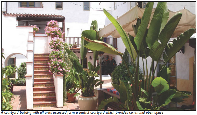 | ||
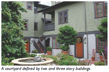 | 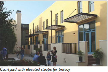 | |
| (All photos are illustrative, not regulatory) | ||
| B. Permitted Transects | ||
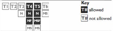 | ||
| C. Number of Units | ||
| Units | 4 min.; 24 max. | |
| D. Building Size and Massing | ||
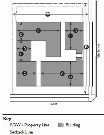 | ||
| Main Body/Secondary Wing(s) | ||
| Height | 2 stories min.; 4 stories max. 1 | See Chapter 58: Building Form Standards |
| Width | 100' max. | |
| Depth | 40' max. | |
| Accessory Structure(s) | ||
| No accessory structures are allowed. | ||
| E. Frontage Requirements | ||
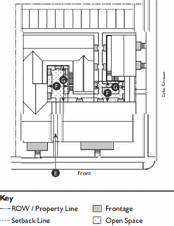 | ||
| Allowed Private Frontages |
Porch, Projecting
Shopfront Stoop Forecourt Gallery Arcade Dooryard | See Chapter 60: Private Frontage Standards for private frontage type descriptions and regulations |
| Entrance Locations | ||
| Main Entry 2 | ||
| Ground Floor Units | Accessible directly off of a courtyard or a street. | |
| Upper Floor Units | Stairs accessing upper floors may serve no more than three units. | |
| Courtyards |
Accessible from the front.
3
| |
| F. Vehicle Access and Parking | ||
| Parking shall be accessed from the alley, side street or front. | ||
| Parking may be accessed from the front only when there is no adjacent alley or side street. | ||
| Parking spaces may be structured, tuck-under, or open. | ||
| Pedestrian connections should link all buildings to the public right-of-way, courtyards, and parking areas. | ||
| G. Private Open Space | ||
| No private open space requirement. | ||
| Courtyard(s) | ||
| Width | 20' min.; 50' max. 4 | |
| Width-to-Height Ratio | 1:2 min. to 2:1 max. 4 | |
| Depth | 20' min.; 150' max. 4 | |
| Depth-to-Height Ratio | 1:1 to 3:1 4 | |
| Area (total) | 400 sf min.; 50 sf/unit min. 4 | |
| Footnotes: | ||
| 1. Height must also comply with Building Form Standards. | ||
| 2. Each unit may have an individual entry. | ||
| 3. Passages through buildings (zaguans) and between buildings should be provided to connect multiple courtyards. | ||
| 4. Buildings must define a minimum of two (2) courtyard edges. Courtyard edges not defined by building should be defined by a six (6) foot stucco or masonry wall. | ||
(Ord. No. 5948, § 1, 7-1-25)
11-59-12: - MAIN STREET MIXED-USE
| A. Description | ||
| Main Street Mixed-Use: This Building Type is a small-to-medium-sized structure, typically attached, intended to provide a vertical mix of uses with ground-floor commercial, service, or retail uses and upper-floor commercial, service, or residential uses. Smaller versions of this Building Type include live/work units. This Building Type makes up the primary component of a neighborhood main street and portions of a downtown main street, therefore being a key component to providing walkability. | ||
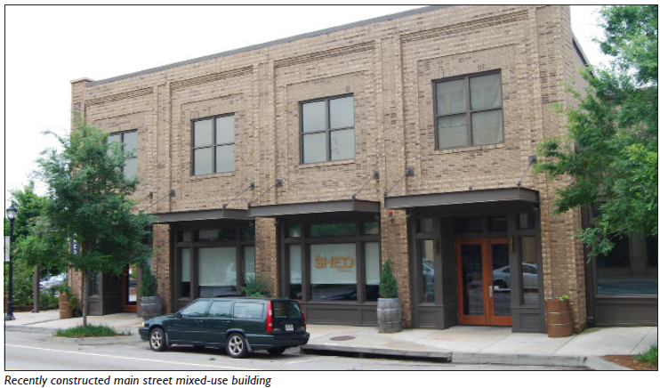 | ||
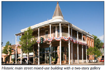 | 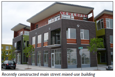 | |
| (All photos are illustrative, not regulatory) | ||
| B. Permitted Transects | ||
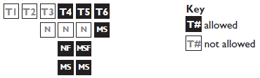 | ||
| C. Number of Units | ||
| Units | 2 min. | |
| D. Building Size and Massing | ||
 | ||
| Main Body | ||
| Height | 2 stories min.; 4 stories max. 1 | See Chapter 58: Building Form Standards |
| Width | 150' max. | |
| Depth | 65' max. | |
| Secondary wing(s)/Accessory Structure(s) | ||
| Width | 100' max. 2 | |
| Depth | 65' max. 2 | |
| Separation from main body | 10' min. | |
| E. Frontage Requirements | ||
 | ||
| Allowed Private Fronages |
Dooryard
Forecourt Gallery Arcade Shopfront Terrace | See Chapter 60: Private Frontage Standards for private frontage type descriptions and regulations |
| Entrance Locations | ||
| Main Body 2 | ||
| Upper Floor Units | Accessed by a common entry along the front. | |
| Ground Floor Units | May have individual entries along the front or side street. | |
| Secondary Wing/Accessory Structure Units | On corner lots, units may front the side street. | |
| F. Vehicle Access and Parking | ||
| Parking shall be accessed from a side street or alley. | ||
| Parking drives and access may be shared on adjacent lots. | ||
| On-site parking spaces may be enclosed or open. | ||
| Garages may be detached or tuck-ender. | ||
| G. Private Open Space | ||
| No private open space requirement. | ||
| Footnotes: | ||
| 1. Height must also comply with Building Form Standards. | ||
| 2. A secondary wing/accessory structure shall have a smaller footprint, a narrower width, and a depth than the main body. | ||
(Ord. No. 5948, § 1, 7-1-25)
11-59-13: - MID-RISE
| A. Description | ||
| Mid-Rise: This Building Type is a medium-to-large-sized structure, four (4) to eight (8) stories tall built on a large lot that incorporates structured parking. This building type can be used to provide a vertical mix of uses with ground-floor commercial, service, or retail uses and upper-floor commercial, service, or residential uses; or may be a single use building, typically service or residential, where ground floor retail is not appropriate. This Building Type is a primary component of an urban downtown providing high-density buildings. | ||
 | ||
 | 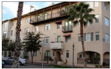 | |
| (All photos are illustrative, not regulatory) | ||
| B. Permitted Transects | ||
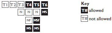 | ||
| C. Lot Requirements | ||
| Lot Coverage | 100% max. | |
| D. Number of Units | ||
| Unrestricted | ||
| E. Building Size, Massing, and Height | ||
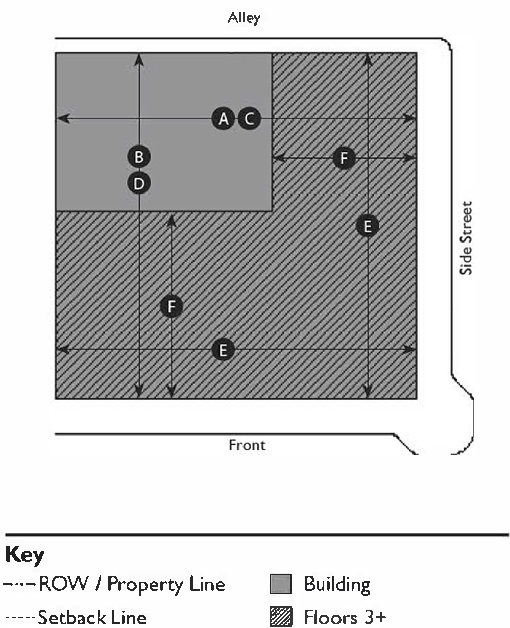 | ||
| Height | 4 stories min.; 8 stories max. 1 | See Chapter 58: Building Form Standards |
| Footprint | ||
| Floors 1—2 | ||
| Width | 200' max. 2 | |
| Depth | 150' max. 2 | |
| Floors 3+ | ||
| Depth | 65' max. 2 | |
| F. Frontage Requirements | ||
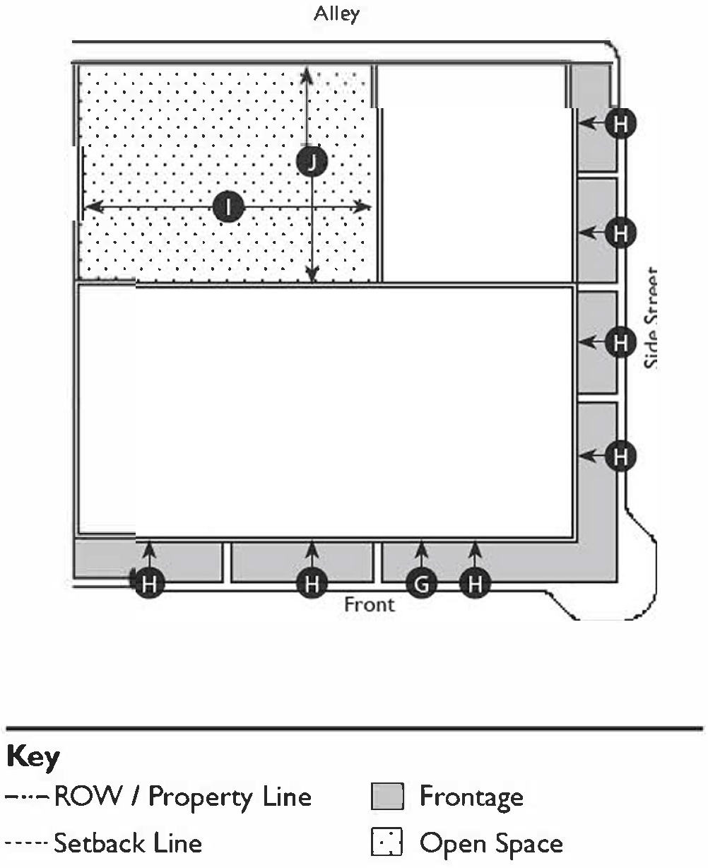 | ||
| Allowed Private Fronages |
Dooryard
Shopfront Gallery Arcade Terrace | See Chapter 60: Private Frontage Standards for private frontage type descriptions and regulations |
| Entrance Locations | ||
| Upper Floor Units | Accessed by a common entry along the front. | |
| Ground Floor Units | May have individual entries along the front or side street. | |
| G. Vehicle Access and Parking | ||
| Parking shall be accessed from the front, alley or side street. | ||
| Parking may be accessed from the front only when there is no adjacent alley or side street. | ||
| On-site parking spaces shall be in a structured garage. 3 | ||
| H. Open Space | ||
| No private open space requirement. | ||
| Building rooftops, including parking structures, should be used to provide open space. | ||
| Courtyard(s) | ||
| Width | 20' min.; 50' max. | |
| Width-to-Height Ratio | 1:2 to 2:1 | |
| Depth | 20' min.; 150' max. | |
| Depth-to-Height Ratio | 1:1 to 3:1 | |
| Footnotes: | ||
| 1. Height must also comply with Building Form Standards. | ||
| 2. The floorplate of any floor may not be larger than the floor below. | ||
| 3. A limited number of surface parking spaces along an alley may be approved by the Planning Director. | ||
(Ord. No. 5948, § 1, 7-1-25)
11-59-14: - HIGH-RISE
| A. Description | ||
| High-Rise: This Building Type is a large-sized structure, more than eight (8) stories tall built on a large lot that incorporates structured parking. This Building Type is used to provide a vertical mix of uses with ground-floor commercial, service, or retail uses and upper-floor commercial, service, or residential uses. It is a primary component of an urban downtown providing high-density buildings | ||
 | ||
 |  | |
| (All photos are illustrative, not regulatory) | ||
| B. Permitted Transects | ||
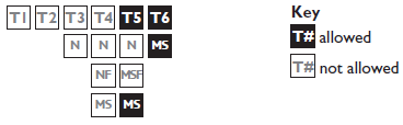 | ||
| C. Lot Requirements | ||
| Lot Coverage | 100% max. | |
| D. Number of Units | ||
| Unrestricted | ||
| E. Building Size, Massing, and Height | ||
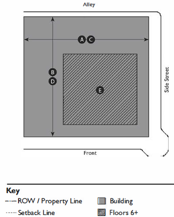 | ||
| Height | 8 stories min. | See Chapter 58: Building Form Standards |
| Footprint | ||
| Floors 1—5 | ||
| Width | 300' max. 1 | |
| Depth | 300' max. 1 | |
| Floors 6—8 | ||
| Floorplate | 80% of lot max. 1 | |
| Floors 9+ | ||
| Residential Floorplate | 15,000 sf max. 1 | |
| Commercial Floorplate | 30,000 sf max. 1 | |
| F. Frontage Requirements | ||
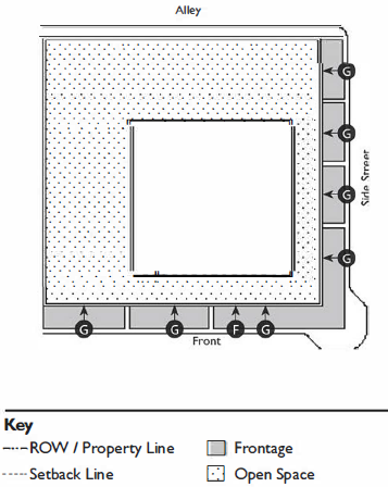 | ||
| Allowed Private Fronages |
Shopfront
Dooryard Gallery Terrace | See Chapter 60: Private Frontage Standards for private frontage type descriptions and regulations |
| Entrance Locations | ||
| Upper Floor Units | Accessed by a common entry along the front. | |
| Ground Floor Units | May have individual entries along the front or side street. | |
| G. Vehicle Access and Parking | ||
| Parking may be accessed from the front, alley or side street. | ||
| Parking may be accessed from the front only when there is no adjacent alley or side street. | ||
| On-site parking spaces shall be in a structured garage. 2 | ||
| H. Private Open Space | ||
| No private open space requirement. | ||
| Building rooftops, including parking structures, should be used to provide open space. | ||
| Footnotes: | ||
| 1. The floorplate of any floor may not be larger than the floor below. | ||
| 3. A limited number of surface parking spaces along an alley may be approved by the Planning Director. | ||
(Ord. No. 5948, § 1, 7-1-25)
11-59-15: - ADDITIONAL STANDARDS FOR MID-RISE AND HIGH-RISE BUILDINGS
| A. High-Rise/Mid-Rise Buildings in T6MS | ||
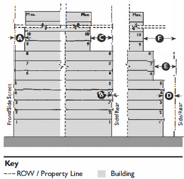 | ||
| Front/Side Street Setback | ||
| Floors 9+ | 10' min. | |
| Side/Rear Setback | ||
| Abutting T6 | ||
| Floors 1—8 | 0' min. | |
| Floors 9+ | 30' min. | |
| Abutting T5 | ||
| Floors 1—5 | 0' min. | |
| Floors 6—8 | 10' min. | |
| Floors 9+ | 30' min. | |
| Abutting T4 | ||
| Floors 1—5 | 10' min. | |
| Floors 6—8 | 10' min. | |
| Floors 9+ | 30' min. | |
| B. High-Rise/Mid-rise Buildings in T5MS | ||
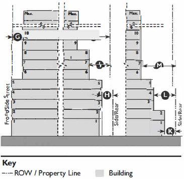 | ||
| Front/Side Street Setback | ||
| Floors 6+ | 10' min. | |
| Side/Rear Setback | ||
| Abutting T6/T5 | ||
| Floors 1—5 | 0' min. | |
| Floors 6—8 | 10' min. | |
| Floors 9+ | 30' min. | |
| Abutting T4 | ||
| Floors 1—5 | 10' min | |
| Floors 6—8 | 20' min. | |
| Floors 9+ | 30' min. | |
| Abutting T3 | ||
| Floors 1—2 | 10' min. | |
| Floors 3—5 | 20' min. | |
| Floors 6+ | 30' min. | |
| C. High-Rise/Mid-Rise Buildings in T5MSF/T5N | ||
 | ||
| Front/Side Street Setback | ||
| Floors 69+ | 10' min. | |
| Side Setback | ||
| Abutting T6/T5/T4 | ||
| Floors 1—5 | 0' min. | |
| Floors 6—8 | 10' min. | |
| Floors 9+ | 30' min. | |
| Abutting T3 | ||
| Floors 1—5 | 10' min. | |
| Floors 6—8 | 20' min. | |
| Floors 9+ | 30' min. | |
| Rear Setback | ||
| Abutting T6/T5/T4 | ||
| Floors 1—5 | 10' min. | |
| Floors 6—8 | 20' min. | |
| Floors 9+ | 30' min. | |
| Abutting T3 | ||
| Floors 1—2 | 10' min. | |
| Floors 3—5 | 20' min. | |
| Floors 6+ | 30' min. | |
| D. Mid-Rise Buildings in T4MS | ||
 | ||
| Front/Side Street Setback | ||
| Floors 4+ | 10' min. | |
| Side Setback | ||
| Floors 1—3 | 0' min. | |
| Floors 4+ | 10' min. | |
| Rear Setback | ||
| Abutting T6/T5/T4 | ||
| Floors 1—3 | 10' min. | |
| Floors 4+ | 20' min. | |
| Abutting T3 | ||
| Floors 1—2 | 10' min. | |
| Floor 3 | 20' min. | |
| Floors 4+ | 30' min. | |
(Ord. No. 5948, § 1, 7-1-25)
11-60-1: - PURPOSE
This Chapter sets forth the standards applicable to the development of private frontages. Private frontages are the components of a building that provide an important transition and interface between the public realm (street and sidewalk) and the private realm (yard or building). These standards supplement the standards for each Transect Zone that the frontage types are allowed within.
(Ord. No. 5948, § 1, 7-1-25)
11-60-2: - APPLICABILITY
The standards within this Chapter shall apply to all proposed development within Transect Zones and shall be considered in combination with the standards for the applicable zone in Chapter 58: Building Form Standards and Chapter 59: Building Type Standards.
(Ord. No. 5948, § 1, 7-1-25)
11-60-3: - COMMON YARD
| A. Description | ||
| Common Yard: The building's main façade features a spacious, landscaped setback from the right-of-way, providing a buffer from traffic. The front yard is unfenced, creating a visually seamless connection with adjacent yards and contributing to a cohesive streetscape. | ||
 |  | |
| (All photos are illustrative, not regulatory) | ||
| B. Size | ||
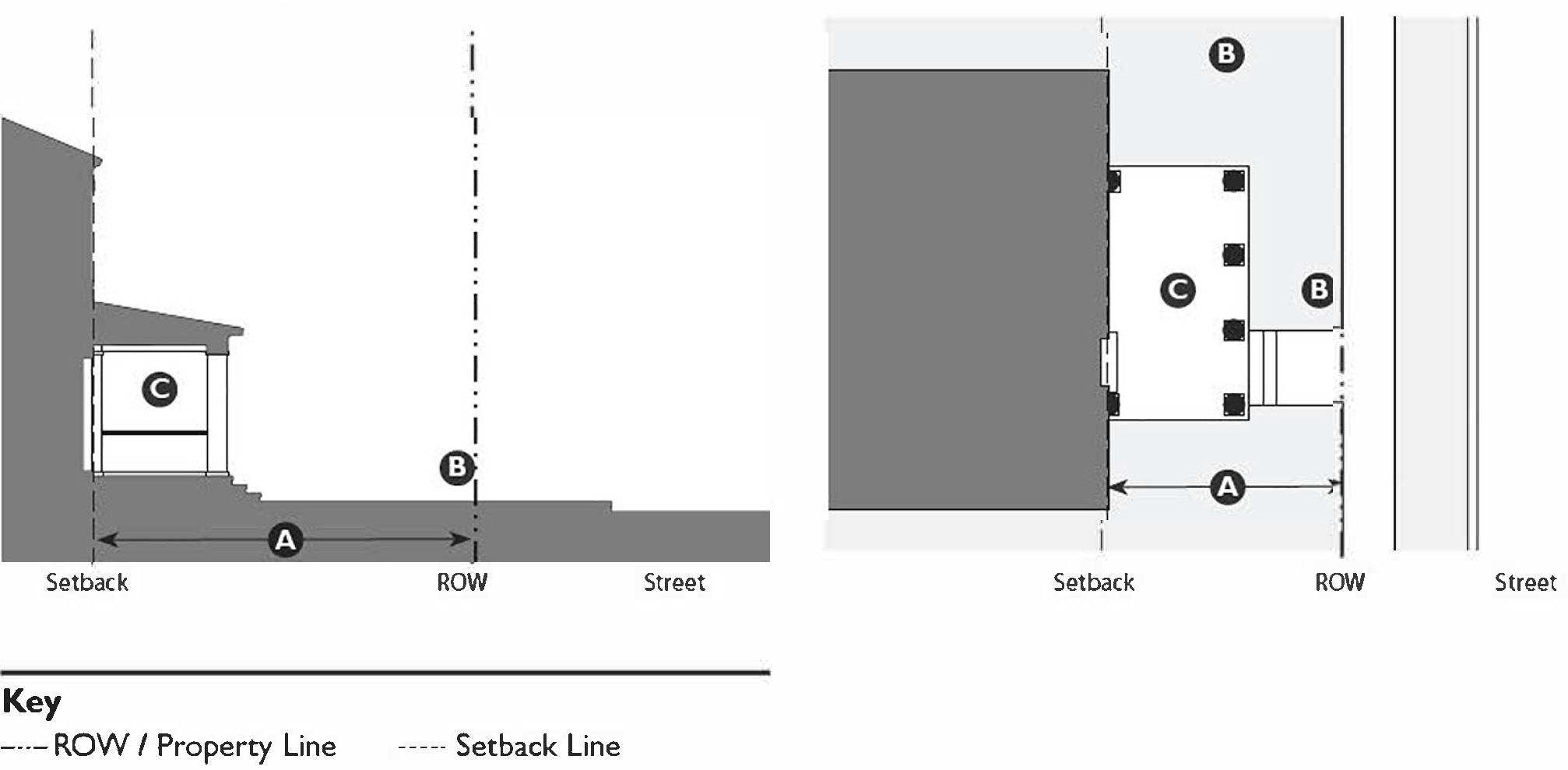 | ||
| Depth | 20' min. | |
| C. Miscellaneous | ||
| Fences are not permitted in front yards including fences on side property lines | ||
| Common Yard Frontages may only be used in conjunction with another allowed private frontage type, such as porch. | ||
(Ord. No. 5948, § 1, 7-1-25)
11-60-4: - PORCH: PROJECTING
| A. Description | ||
| Porch, projecting: The building's main façade features a modest setback from the right-of-way, creating a small front yard that may be defined by a fence or hedge to define the street edge. The projecting porch is open on three (3) sides, with all habitable space located behind the setback line. | ||
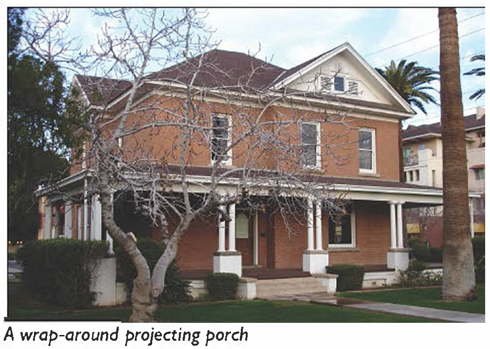 | 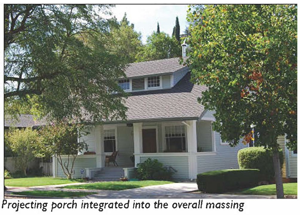 | |
| (All photos are illustrative, not regulatory) | ||
| B. Size | ||
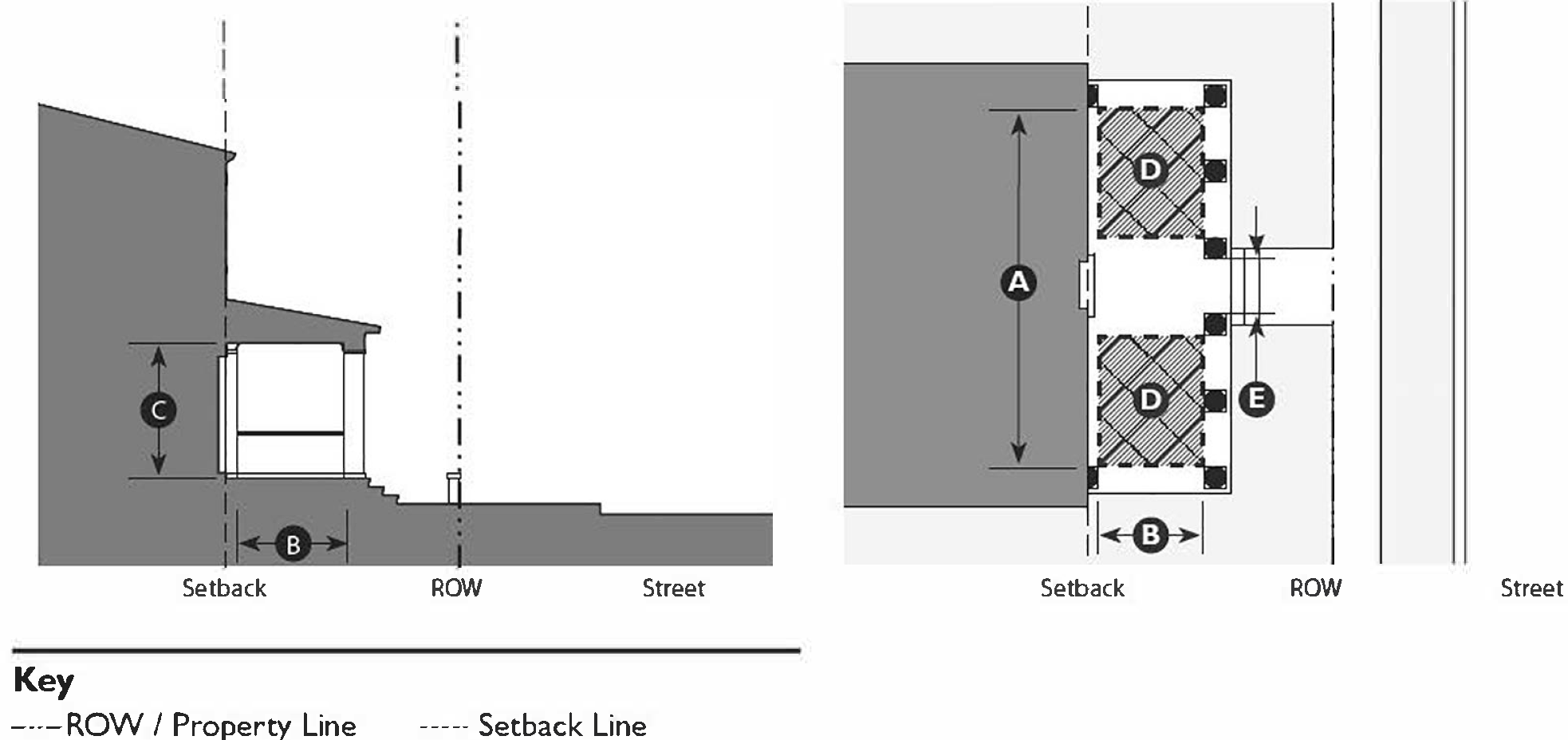 | ||
| Width, clear | 10' min. 1 | |
| Depth, clear | 8' min. 1 | |
| Height, clear | 8' min. | |
| Height, top of covering | 2 stories max. | |
| Furniture area, clear | 4' × 6' min. | |
| Path of travel | 3' wide min. | |
| Footnotes: | ||
| 1. A Projecting Porch must have a roof that covers the entire porch. | ||
(Ord. No. 5948, § 1, 7-1-25)
11-60-5: - PORCH: ENGAGED
| A. Description | ||
| Porch, engaged: The building's main façade features a modest setback from the right-of-way, creating a small front yard, often defined by a fence or hedge to clearly define the street edge. The engaged porch is attached to the building on two (2) sides, while the remaining two (2) sides are open. | ||
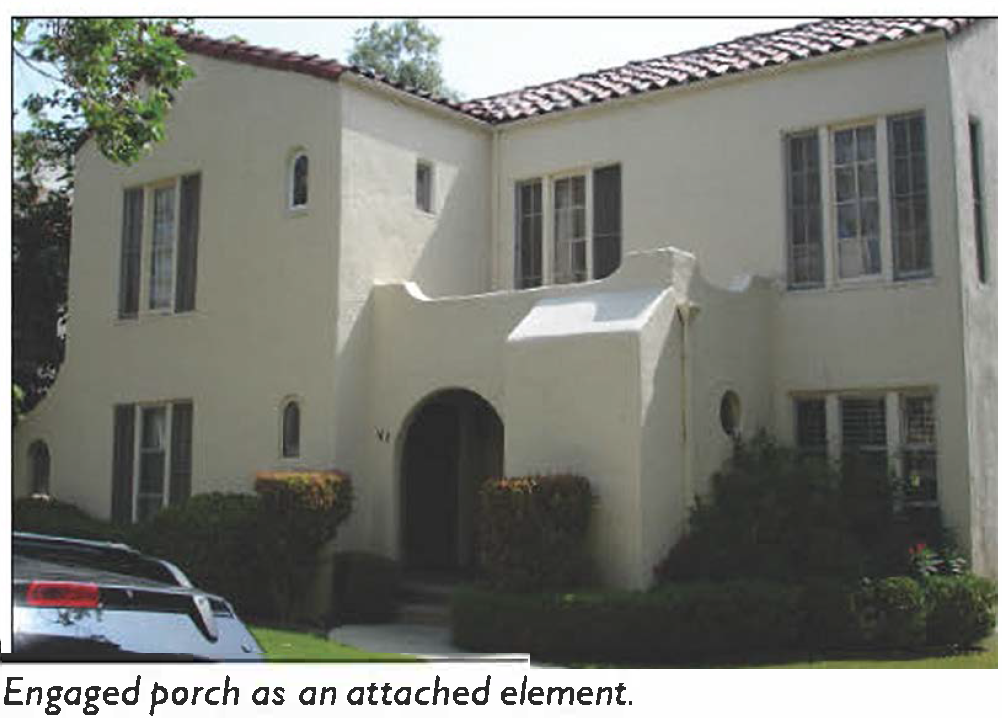 | 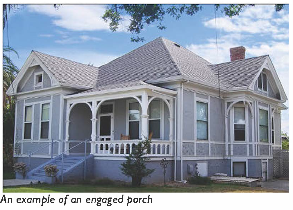 | |
| (All photos are illustrative, not regulatory) | ||
| B. Size | ||
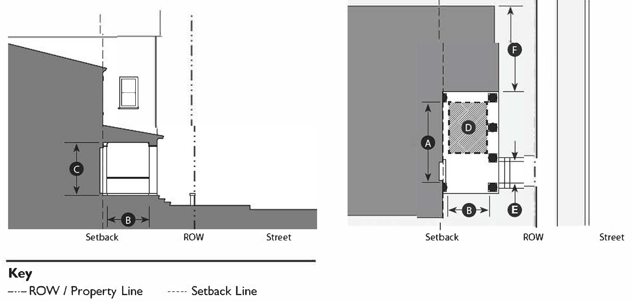 | ||
| Width, clear | 10' min. 1 | |
| Depth, clear | 8' min. 1 | |
| Height, clear | 8' min. | |
| Height, top of covering | 2 stories max. | |
| Furniture area, clear | 4' × 6' min. | |
| Path of travel | 3' wide min. | |
| C. Encroachments | ||
| Up to ⅖ of the building façade may project beyond the setback line into the encroachment area for this frontage type. | ||
| Footnotes: | ||
| 1. An Engaged Porch must have a roof that covers the entire porch. | ||
(Ord. No. 5948, § 1, 7-1-25)
11-60-6: - STOOP
| A. Description | ||
| Stoop: The building's main façade is located near the right-of-way, with an elevated stoop that engages the sidewalk. The stoop is raised above the sidewalk to ensure privacy within the building. Stairs from the stoop may lead directly to the sidewalk or may be perpendicular to the sidewalk. Stoops are appropriate for residential uses with small setbacks. | ||
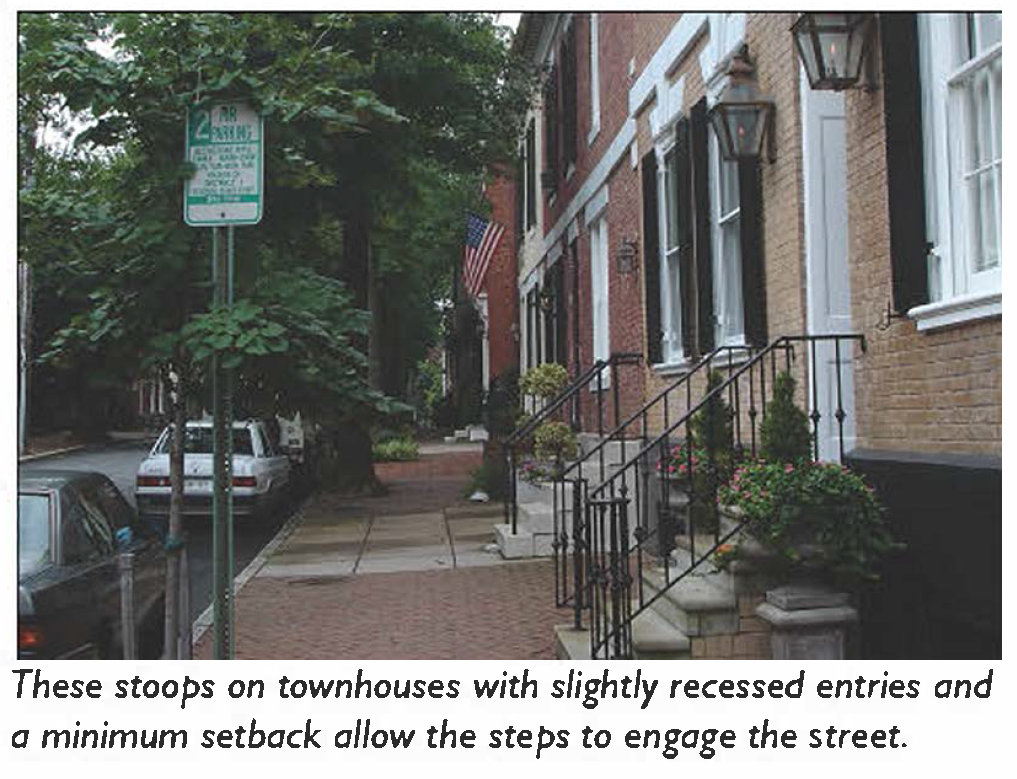 | 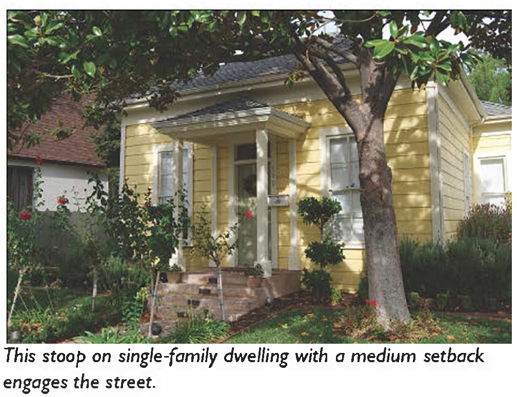 | |
| (All photos are illustrative, not regulatory) | ||
| B. Size | ||
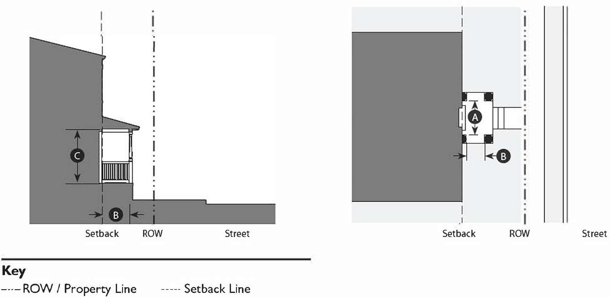 | ||
| Width, clear | 5' min.; 8' max. | |
| Depth, clear | 5' min.; 8' max. | |
| Height, clear | 8' min. | |
| Height, top of covering | 1 story max. | |
| Depth of recessed entries | 6' max. | |
| C. Miscellaneous | ||
| Stairs may be perpendicular or parallel to the building façade. | ||
| Ramps shall be parallel to façade or along the side of the building. | ||
| The entry door shall be covered or recessed to provide shelter from the elements. | ||
| All doors must face the street. | ||
(Ord. No. 5948, § 1, 7-1-25)
11-60-7: - FORECOURT
| A. Description | ||
| Forecourt: The building's main façade is at or near the right-of-way, with a small portion of the façade set back to create a small courtyard. This area can serve as an entry court, a shared garden space for apartment buildings, or as an additional shopping or restaurant seating area. | ||
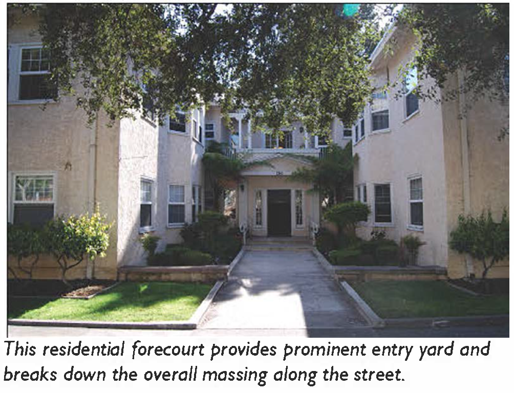 | 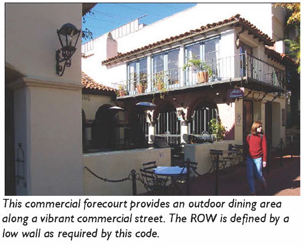 | |
| (All photos are illustrative, not regulatory) | ||
| B. Size | ||
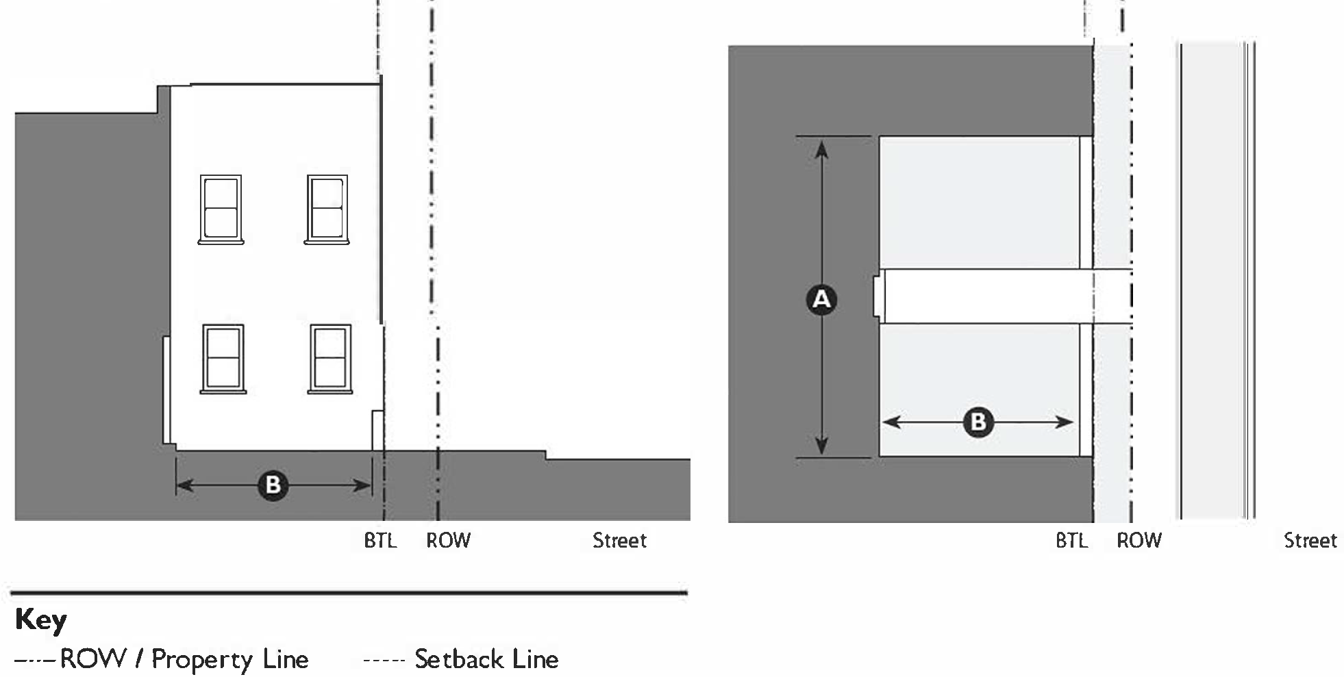 | ||
| Width, clear | 12' min. | |
| Depth, clear | 12' min. | |
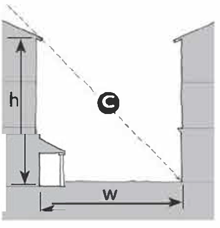 | ||
| Ratio, Height to Width | 2:1 max. | |
| C. Miscellaneous | ||
| Within Neighborhood and Flex zones, a Forecourt cannot be used on parcels with more than one (1) adjacent parcel using a Forecourt. | ||
| Within Main Street zones, a Forecourt cannot be used on a parcel if an adjacent parcel has a Forecourt. | ||
| The proportions and orientation of these spaces should be carefully considered for solar orientation and user comfort. | ||
(Ord. No. 5948, § 1, 7-1-25)
11-60-8: - DOORYARD
| A. Description | ||
| Dooryard: The transition from the public to private realm is defined by a low wall or hedge placed just behind the right-of-way with the main building façade setback a small distance, creating a small dooryard. The dooryard may be raised, sunken, or at grade, and is intended for ground floor residential in flex zones, live/work, and small commercial uses ≤2,500 sf. | ||
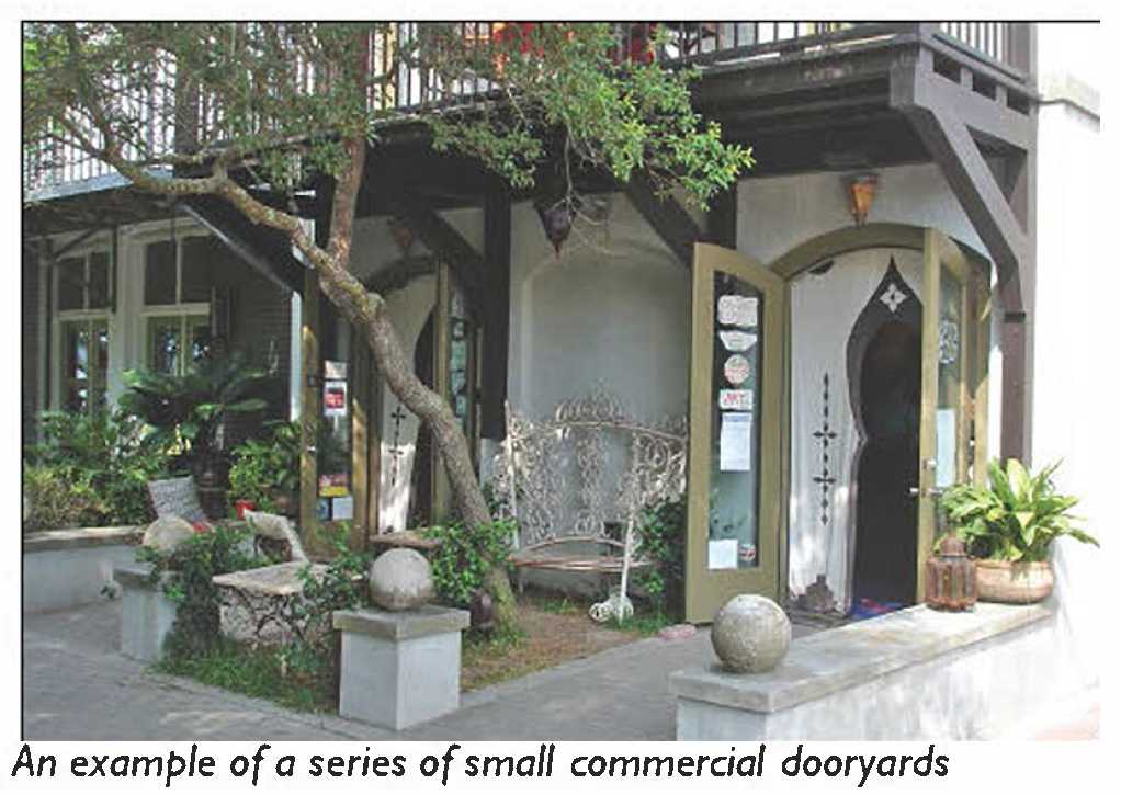 | 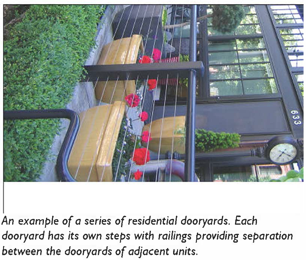 | |
| (All photos are illustrative, not regulatory) | ||
| B. Size | ||
 | ||
| Depth, clear | 8' min. | |
| Length | 50' max. | |
| Distance between glazing | 4' max. 1 | |
| Ground floor transparency | 50% min. 2, 3 | |
| Depth of recessed entries | 5' max. | |
| Path of travel | 3' wide min. | |
| Finish level above sidewalk | 3'-6' max. | |
| Finish level below sidewalk | 6' max. | |
| C. Miscellaneous | ||
| For Live/Work and Commercial Uses, these standards are to be used in conjunction with those for the Shopfront Frontage Type. In case of conflict between them, the Dooryard standards shall prevail. | ||
| Low walls (12"-36") used as seating are encourage. | ||
| Shall not be used for circulation for more than one (1) ground floor entry. | ||
| Footnotes: | ||
| 1. May be increased if located outside of the Downtown Pedestrian Area, and superior building design standards are utilized including building wall articulation and changes in materials and colors, as reviewed with the Zoning Clearance. | ||
| 2. For live/work and commercial uses only. | ||
| 3. Minimum 40% if located outside the Downtown Pedestrian Area and superior, pedestrian-scale building design, with changes in color, material and texture is utilized, as reviewed with the Zoning Clearance. | ||
(Ord. No. 5948, § 1, 7-1-25)
11-60-9: - SHOPFRONT
| A. Description | ||
| Shopfront: The building's main façade is at or near the right-of-way with an at-grade entrance directly accessible from the public right-of-way. Designed primarily for retail use, it features substantial glazing at the sidewalk level and may include an awning that extends over the sidewalk. Shopfronts may be used in conjunction with other frontage types. Syn: Retail Frontage, Awning. | ||
 |  | |
| (All photos are illustrative, not regulatory) | ||
| B. Size | ||
 | ||
| Distance between glazing | 2' max. 1 | |
| Ground floor transparency | 75% min. 2 | |
| Depth of recessed entries | 5' max. | |
| C. Awning | ||
| Depth | 4' min. | |
| Setback from curb | 2' min. | |
| Height, clear | 8' min. | |
| D. Miscellaneous | ||
| Residential windows shall not be uses. | ||
| Operable awnings are encouraged. | ||
| Open-ended awnings encourage. | ||
| Rounded and hooped awnings are discourage. | ||
| Shopfronts with accordion-style doors/windows or other operable windows that allow the space to open to the street are encouraged. | ||
| Footnotes: | ||
| 1. May be increased if located outside of the Downtown Pedestrian Area, and superior building design standards are utilized including building wall articulation and changes in materials and colors, as reviewed with the Zoning Clearance. | ||
| 2. May be reduced to 50% if located outside the Downtown Pedestrian Area and results in superior building wall articulation and design, with further reduction to 40% if pedestrian-scale design is utilized, with changes in color, material and texture, as reviewed with the Zoning Clearance. | ||
(Ord. No. 5948, § 1, 7-1-25)
11-60-10: - TERRACE
| A. Description | ||
| Terrace: The building's main façade is at or near the right-of-way, with an elevated terrace providing public circulation along the façade. This design allows for at-grade access while allowing grade changes. Frequent steps leading up to the terrace are essential to avoid blank walls and ensure accessibility. Terraces may be used in historic industrial areas to mimic historic loading docks. | ||
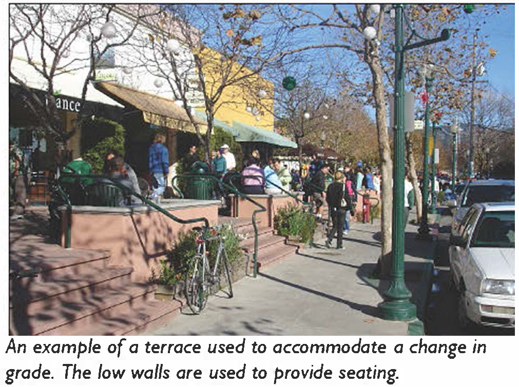 | 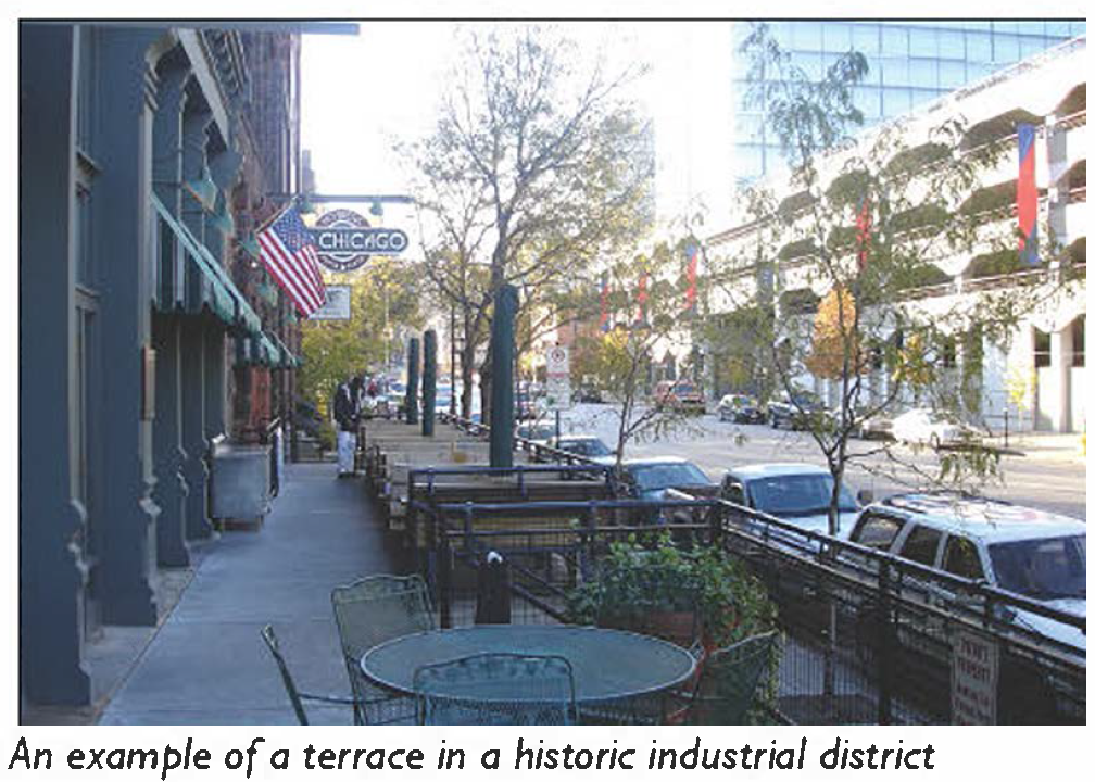 | |
| (All photos are illustrative, not regulatory) | ||
| B. Size | ||
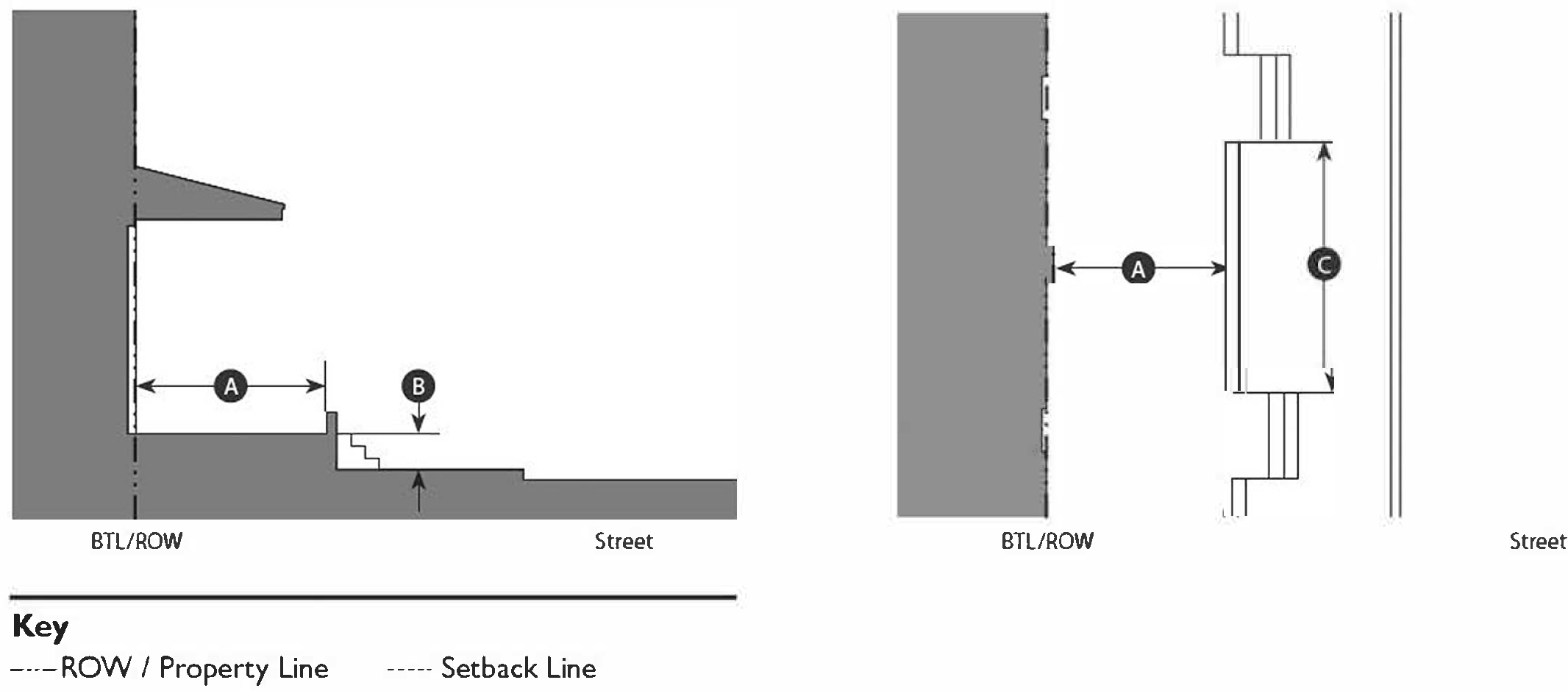 | ||
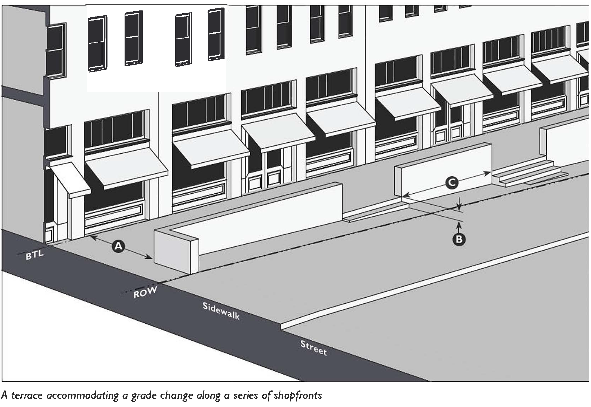 | ||
| Depth, clear | 8' min. | |
| Finish level above sidewalk | 3'6" max. | |
| Length of terrace | 150' max. | |
| Distance between stairs | 50' max. | |
| C. Miscellaneous | ||
| These standards are to be used in conjunction with those for the Shopfront Frontage Type. In case of conflict between them, the Terrace standards shall prevail. | ||
| Low walls used as seating are encouraged. | ||
(Ord. No. 5948, § 1, 7-1-25)
11-60-11: - GALLERY
| A. Description | ||
| Gallery: The building's main façade is at the right-of-way, and the gallery element extends over the sidewalk. Designed for buildings with ground-floor commercial uses, the gallery can be one (1) or two (2) stories high. The gallery provides primary circulation along the building frontage, projecting far enough from the building to provide both protection and adequate space for pedestrians. | ||
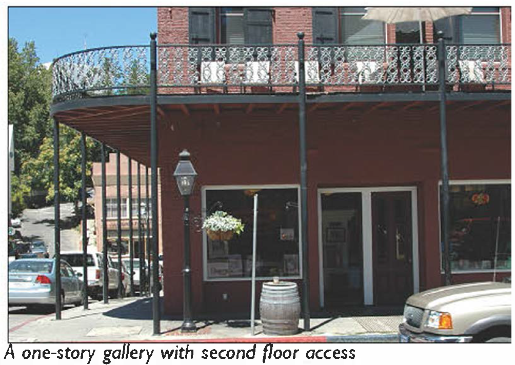 | 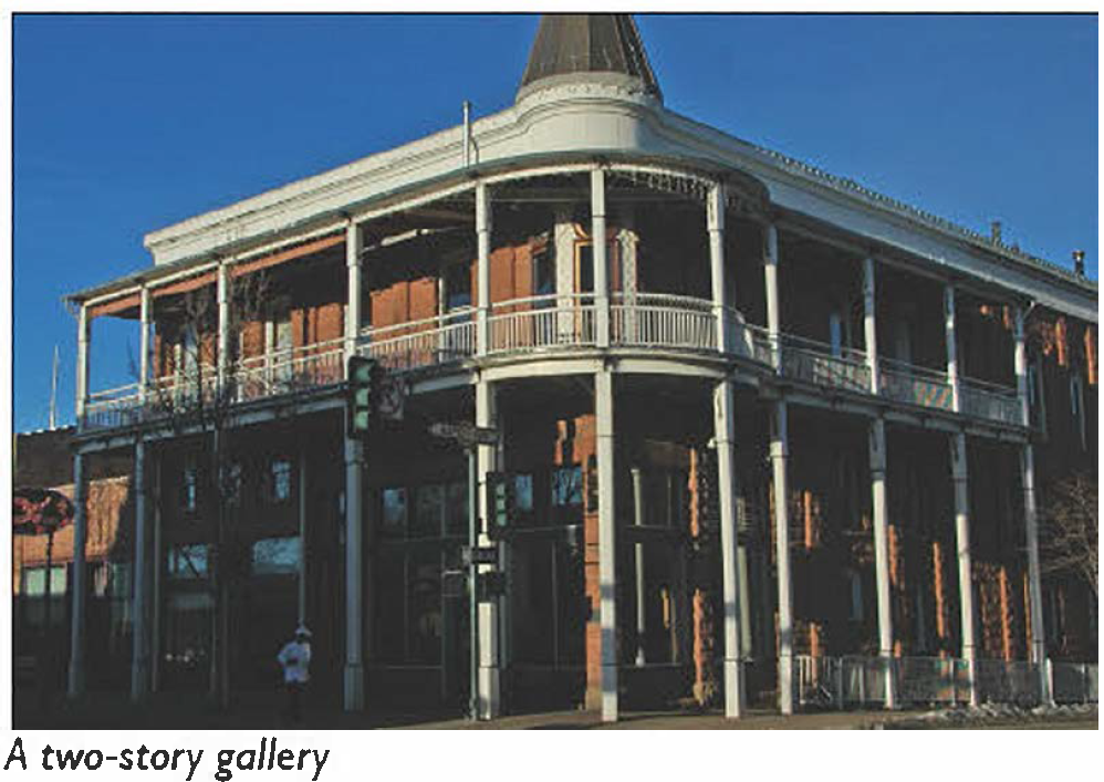 | |
| (All photos are illustrative, not regulatory) | ||
| B. Size | ||
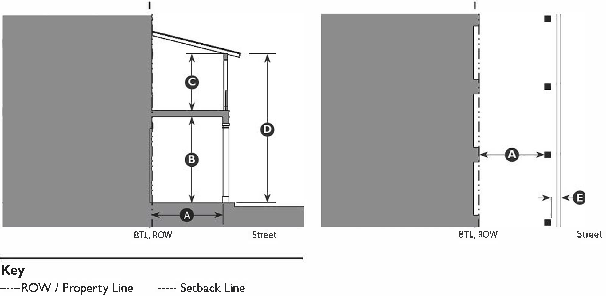 | ||
| Depth, clear | 8' min. 1 | |
| Ground floor height, clear | 11' min. | |
| Upper floor height, clear | 9' min. | |
| Height, top of covering | 3 stories max. | |
| Setback from curb | 3' min. 2 | |
| C. Miscellaneous | ||
| These standards are to be used in conjunction with those for the Shopfront Frontage Type. In case of conflict between them, the Terrace standards shall prevail. | ||
| Upper-story galleries facing the street must not be used to meet primary circulation requirements. | ||
| Footnotes: | ||
| 1. Galleries must have a consistent depth along a frontage. | ||
| 2. Galleries must project over a sidewalk. | ||
(Ord. No. 5948, § 1, 7-1-25)
11-60-12: - ARCADE
| A. Description | ||
| Arcade: A covered walkway with habitable space above, and often extending over, the right-of-way. The arcade serves as the primary circulation space along the frontage, projecting sufficiently from the building to provide protection and facilitate pedestrian movement. This design is typically used for buildings with ground floor commercial uses and is commonly found along public courtyards and paseos. | ||
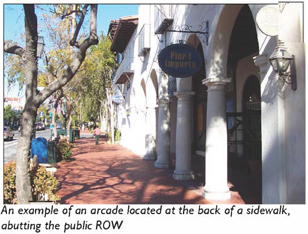 | 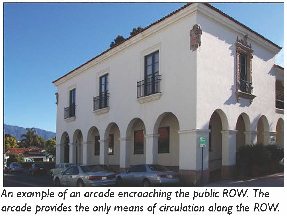 | |
| (All photos are illustrative, not regulatory) | ||
| B. Size | ||
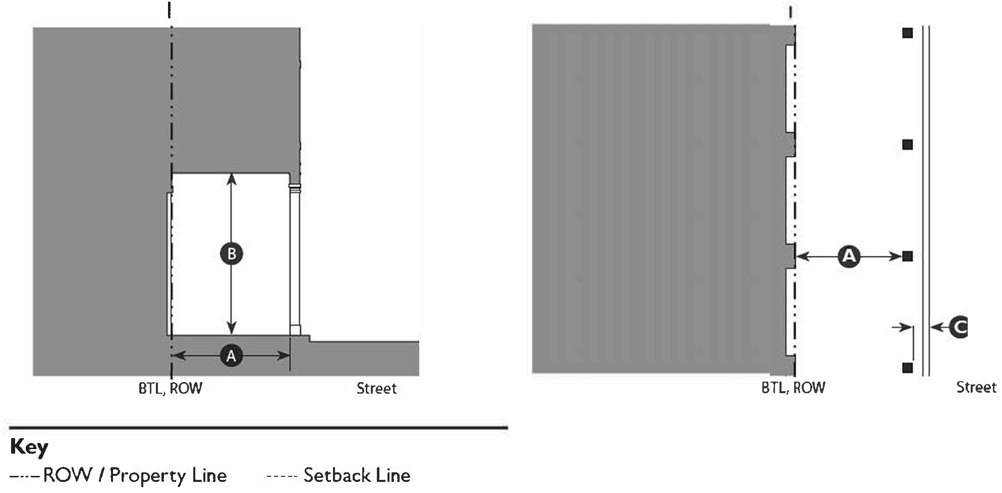 | ||
| Depth, clear | 12' min. 1 | |
| Ground floor height, clear | 14' min. clear | |
| Setback from edge of curb | 3' min. | |
| C. Miscellaneous | ||
| These standards are to be used in conjunction with those for the Shopfront Frontage Type. In case of conflict between them, the Terrace standards shall prevail. | ||
| Arcades with more than two (2) floors of habitable space above the colonnade may not encroach into the right-of-way and must be located so that it abuts the right-of-way. | ||
| Footnote: | ||
| 1. Arcades must have a consistent depth along a frontage. | ||
(Ord. No. 5948, § 1, 7-1-25)
11-61-1: - PURPOSE
A.
The intent of this Chapter is to provide a catalog of pre-approved thoroughfare assemblies and components that are appropriate to use within transect zones. These components can be combined to form thoroughfares that can be used in developments. The standards in this Chapter are intended to help minimize the amount of back-and-forth with the Planning Department, City Traffic Engineer, Fire Department, Solid Waste Management, and City Engineer.
B.
Application of thoroughfares will balance the needs of pedestrians with vehicles. To make a more pedestrian-friendly environment, design speeds will generally be lower and traffic congestion will generally be higher when compared to thoroughfares in other parts of the City.
11-61-2: - APPLICABILITY
A.
This Chapter describes thoroughfare assemblies, formulas, and components and assemblies approved for the development of thoroughfares in transect zones. It supplements the "Engineering Standards." Where these standards conflict with the "Engineering Standards", the standards of this Chapter shall prevail.
B.
These thoroughfare standards are applicable for the transformation of existing thoroughfares and the creation of new thoroughfares in any areas within the transect zones.
C.
The placement and use of thoroughfare assemblies is subject to review through the development of a Street Regulating Plan per Chapter 63 (Smart Growth Community Plans) Section 11-63-6 (Thoroughfares).
D.
Additional thoroughfare assemblies can be integrated into this Chapter as they are approved by the City.
11-61-3: - ALLOWED THOROUGHFARES
Allowed throughfares shall follow the process diagram in Table 11-61-3.A (Allowed Thoroughfare Process Diagram) and are allowed by right or with the specified approvals as follows:
A.
Predefined thoroughfare assemblies found in Section 11-61-8 (Thoroughfare Assemblies) are allowed by right.
B.
Thoroughfares that meet the standards found in Table 11-61-9.A (Thoroughfare Formulas) and use only the predefined components in Tables 11-61-9.B-H are allowed By Right or By Review as follows (Thoroughfares allowed By Review are allowed if approved by the Director and City Traffic Engineer.):
1.
If all of the selected predefined components are allowed By Right, the thoroughfare is allowed By Right.
2.
If one or more of the selected predefined components is allowed By Review, the thoroughfare is allowed By Review.
C.
Thoroughfares that meet the standards found in Table 11-61-9.A (Thoroughfare Formulas) but do not use only the predefined components in Tables 11-61-9.B-H are allowed if approved by the Director, City Traffic Engineer, Fire Department, Solid Waste Management, and City Engineer.
D.
Thoroughfares that do not meet the standards in items A-C above are not allowed in any Transect zones.
Table 11-61-3.A: Allowed Thoroughfare Process Diagram
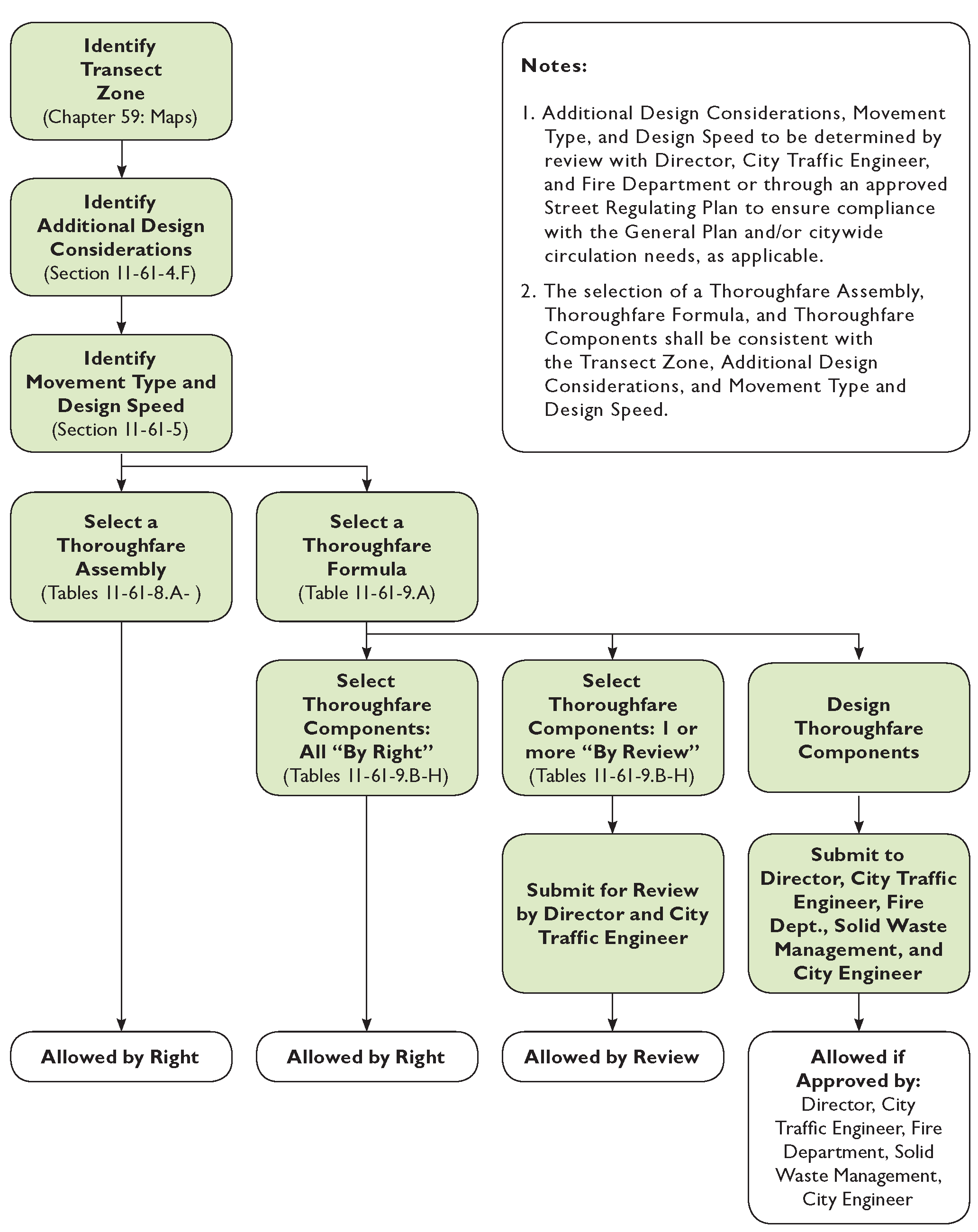
11-61-4: - THOROUGHFARE DESIGN
A.
Thoroughfares are intended for use by vehicular and pedestrian traffic and to provide access to lots and open spaces.
B.
Thoroughfares shall generally consist of vehicular lanes and public frontages.
C.
Thoroughfares shall be designed in context with the urban form and general intention of the transect zones through which they pass.
1.
Within the more urban transect zones (T3 through T6) pedestrian comfort shall be a primary consideration of the thoroughfare design. Design conflict between vehicular and pedestrian movement generally shall be decided in favor of the pedestrian.
2.
Within the most rural transect zones (T1 and T2) pedestrian comfort shall be a secondary consideration of the thoroughfare design. Design conflict between vehicular and pedestrian movement generally shall be decided in favor of the vehicle.
D.
The requirements for pedestrian and bicyclist safety, comfort and access shall establish thoroughfare movement type and design speed. The movement type and design speed shall be the primary consideration used to determine the dimensions of each thoroughfare element, such as vehicular lanes and turning (curb) radii.
E.
Thoroughfares shall be designed to accommodate the types of vehicles expected to use each thoroughfare on a daily basis. Occasionally, large vehicles are expected on all thoroughfares. All thoroughfares shall allow these vehicles to safely pass without major difficulty. It is expected that large vehicles may encroach on the opposing lane when making turning movements.
F.
Additional Design Considerations. Other factors that may need to be considered in the selection of an appropriate thoroughfare type in transect zones include the following:
1.
Topography. Thoroughfares that traverse steep slopes may need to incorporate additional design consideration for such elements as drainage facilities, additional width for bicycle lanes on the uphill side of the thoroughfare, etc.
2.
Parking. The provision of parking on site or on the thoroughfare may need to be considered in the selection of the appropriate thoroughfare type.
3.
Truck Access. Thoroughfares that provide access to high volumes of large trucks may need additional design considerations to mitigate potential negative effects on walkability.
4.
Bus Service. Thoroughfares that will serve as public transit or school bus routes may need additional design considerations, including, but not limited to, the location of bus stops.
5.
Fire/Emergency Access. Additional design considerations may be needed to accommodate Fire/Emergency Access, including, but not limited to, the location of rolled curbs and bulb-outs to accommodate fire truck outriggers.
G.
All lane dimensions shall be measured to the face of the curb. Where no curb and gutter is provided, the lane dimension shall be to the edge of the pavement. For Yield movement types, lane dimensions assume two-way traffic and are for a single lane accommodating two-way traffic.
H.
Shared lanes with sharrow markings on the travel lanes or a bicycle boulevard, a road shared by bicycles and vehicles, are allowed and may be required on streets with a design speed of 25 mph or less. Bike Lanes may also be required to provide continuity between neighborhoods or based on traffic volumes. See Table 11-61-9.B (Bicycle Facilities Standards) for minimum dimensions.
11-61-5: - MOVEMENT TYPES AND DESIGN SPEED
Movement types are intended to assist in the selection of the appropriate thoroughfare design for the necessary level of pedestrian and bicyclist safety and comfort at any given location. Design speed is the primary determinant of movement type. A list of approved movement types (along with their assigned lane widths and curb radii) is provided for each transect zone in Tables 11-61-9.A-D.
Following is a list of movement types:
A.
Yield. Drivers must proceed slowly, with extreme care, and must yield to approaching traffic when vehicles are parked on both sides of the thoroughfare creating essentially one through lane. A Yield Thoroughfare is the functional equivalent of traffic calming. In addition to Yield movement use on normal thoroughfares, this movement is used for Alleys and Rear Lanes. For these applications, the primary purpose is access to rear loaded driveways/access for residential and commercial property. The 12' travel lane for Rear Lanes can be configured for one-way or two-way operation. When used for two way travel, parking is required on both sides of street in order to facilitate the Yield Movement Type and drivers exiting garages or driveways will have to yield to those vehicles occupying the lane therefore the number of properties connected to the Rear Lane should be considered. Parking in Alleys and Rear Lanes should only occur in driveways or parking structures to allow access for trash collection, service trucks and emergency access. Design speed is less than 20 mph.
B.
Slow. Drivers can proceed carefully with an occasional stop to allow a pedestrian to cross or another car to park. The character of the thoroughfare should make drivers uncomfortable exceeding the design speed due to the presence of parked cars, sense of enclosure from buildings and street trees, tight turning radii, and other design elements. Design speed is 20-25 mph.
C.
Low. Drivers can generally expect to travel without delay at the appropriate design speed. Thoroughfare design supports safe pedestrian movement at the higher design speed. This movement type is appropriate for thoroughfares designed to traverse longer distances or connect to higher intensity locations. Design speed is 30-35 mph.
D.
Suburban. This is a conventional thoroughfare design in which drivers can expect a separation of modes, (i.e., bike lanes, walking paths and roads) allowing automobiles to travel unimpeded by pedestrians or walkability concerns. This movement type is rarely used in T3 through T6 transect zones, but may be needed when a thoroughfare crosses through T1 or T2 transect zones. Design speed may be above 35 mph.
The design criteria for Yield, Slow, and Low Thoroughfares shall be commensurate with local thoroughfares. Design speeds higher than 35 mph shall not be used in areas intended to support moderate or high levels of pedestrian or bicycle activity due to concerns with safety and comfort.
11-61-6: - INTERSECTIONS
A.
Street design of narrow streets and compact intersections requires designers to pay close attention to the operational needs of transit, fire and rescue, waste collection and delivery trucks. For this reason, early coordination with transit, fire and rescue, waste collection and other stakeholder groups is essential.
B.
More regular encroachment of turning vehicles into opposing lanes will occur at compact intersections. Therefore, frequency of access, traffic volumes and the speeds on intersecting streets at those intersections must be considered when designing intersections. For fire and rescue, determination of the importance of that street for community access should be determined, e.g. primary or secondary access.
C.
The designer should use turning templates or software to evaluate intersections to ensure adequate operation of vehicles can occur. Location of on street parking around intersections should be evaluated during this analysis to identify potential conflicts between turning vehicles and on street parking. Bike lanes and on-street parking will increase the effective curb return radius, when curb extensions are not employed, by providing more room for the wheel tracking of turning vehicles.
11-61-7: - PUBLIC FRONTAGES
A.
General to All Transect Zones
1.
The public frontage contributes to the character of the transect zone, and includes the types of sidewalk, curb, planter, and street trees.
2.
Public frontages shall be designed and allocated within transect zones as shown in Tables 11-61-9.E-F
3.
Within the public frontages, the prescribed types of public planting and public lighting shall be as shown in Tables 11-61-9.E-H. The spacing of the public planting may be adjusted with the approval of the Director to accommodate specific site conditions.
B.
Specific To Transect Zones T1, T2, T3
1.
The public frontage shall include trees of various species, naturalistically clustered, as well as understory.
2.
The introduced landscape shall consist primarily of native species requiring minimal irrigation, fertilization and maintenance. Lawn shall be permitted only with approval by the Director.
C.
Specific To Transect Zones T4, T5, T6
1.
The introduced landscape shall consist primarily of durable species tolerant of soil compaction.
2.
Above ground utility facilities shall be placed to minimize the impact on pedestrians.
D.
Specific To Transect Zones T4
1.
The public frontage shall include trees planted in a regularly-spaced allee pattern of single or alternated species with shade canopies of a height that, at maturity, clears at least one Story.
E.
Specific To Transect Zones T5, T6
1.
The public frontage shall include trees planted in a regularly-spaced allee pattern of single species with shade canopies of a height that, at maturity, clears at least one Story. At retail frontages, the spacing of the trees may be irregular, to avoid visually obscuring the shopfronts.
2.
Streets with a Right-of-Way width of 40 feet or less shall be exempt from the tree requirement.
11-61-8: - THOROUGHFARE ASSEMBLIES
A.
This section provides thoroughfare assemblies that have been approved by the City for use in transect zones.
B.
The tables in this section are added into the City of Mesa Engineering and Design Standards.
 | |
| Highway: | HW |
| Boulevard: | BV |
| Avenue: | AV |
| Commercial Street: | CS |
| Drive: | DR |
| Street: | ST |
| Road: | RD |
| Rear Alley: | RA |
| Rear Lane: | RL |
| Bicycle Trail: | BT |
| Bicycle Lane: | BL |
| Bicycle Route: | BR |
| Path: | PT |
| Passage: | PS |
| Transit Route: | TR |
Table 11-61-8.A: Thoroughfare Assembly BV-130-84
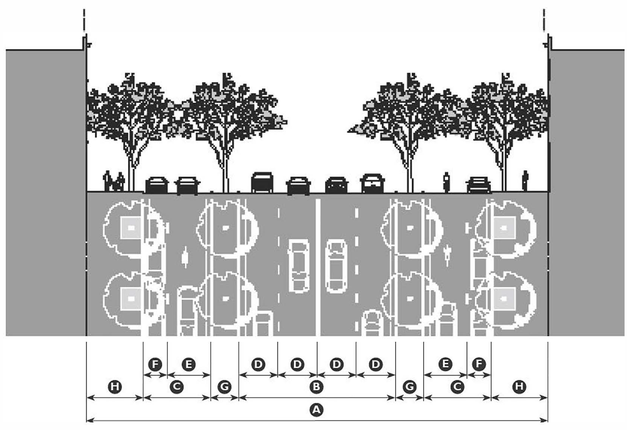
| Application | ||
| Transect Zones | T5MSF, T5MS, T6MS | |
| Movement Type | Low/Slow | |
| Design Speed | ||
| Through Travel Lanes | 35 mph | |
| Local Travel Lanes | 20 mph | |
| Overall Widths | ||
| Right-of-Way (ROW) Width | 130' | |
| Pavement Width | ||
| Through Travel Lanes | 44' | |
| Local Travel | 2@20' | |
| Lane Assembly | ||
| Traffic Lanes | ||
| Through Travel Lanes | 4@11' | |
| Local Travel Lanes 1 | 2@12' | |
| Parking Lanes | 2@8', marked | |
| Medians | 2@8' | |
| 1 Local travel lanes shall be shared bicycle lanes. | ||
| Public Frontage Assembly | ||
| Frontage Type | Boulevard | |
| Drainage Collection Type | Curb and Gutter | |
| Planter Type | 4'×4' Tree Well | |
| Landscape Type | Trees at 30' o.c. Avg. | |
| Lighting Type | Column/Double Column | |
| Walkway Type | 15' Sidewalk | |
| Curb Type | Square | |
Table 11-61-8.B: Thoroughfare Assembly CS-100-60
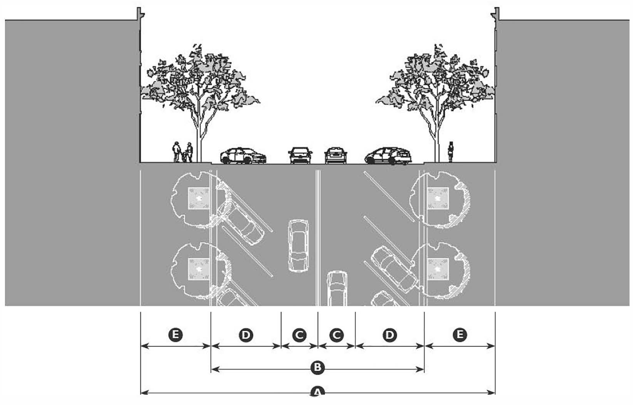
| Application | ||
| Transect Zones | T4MS, T5MSF, T5MS | |
| Movement Type | Slow | |
| Design Speed | 20 mph | |
| Overall Widths | ||
| Right-of-Way (ROW) Width | 100' | |
| Pavement Width | 60' | |
| Lane Assembly | ||
| Traffic Lanes | 2@12' | |
| Bicycle Lanes | None | |
| Parking Lanes | 2@18', marked | |
| Medians | None | |
| Public Frontage Assembly | ||
| Frontage Type | Commercial Street | |
| Drainage Collection Type | Curb and Gutter | |
| Planter Type | 4'×4' Tree Well | |
| Landscape Type | Trees at 30' o.c. avg. | |
| Lighting Type | Post, Column, or Double Column | |
| Walkway Type | 20' sidewalk | |
| Curb Type | Square | |
Table 11-61-8.C: Thoroughfare Assembly CS-100-48-BL
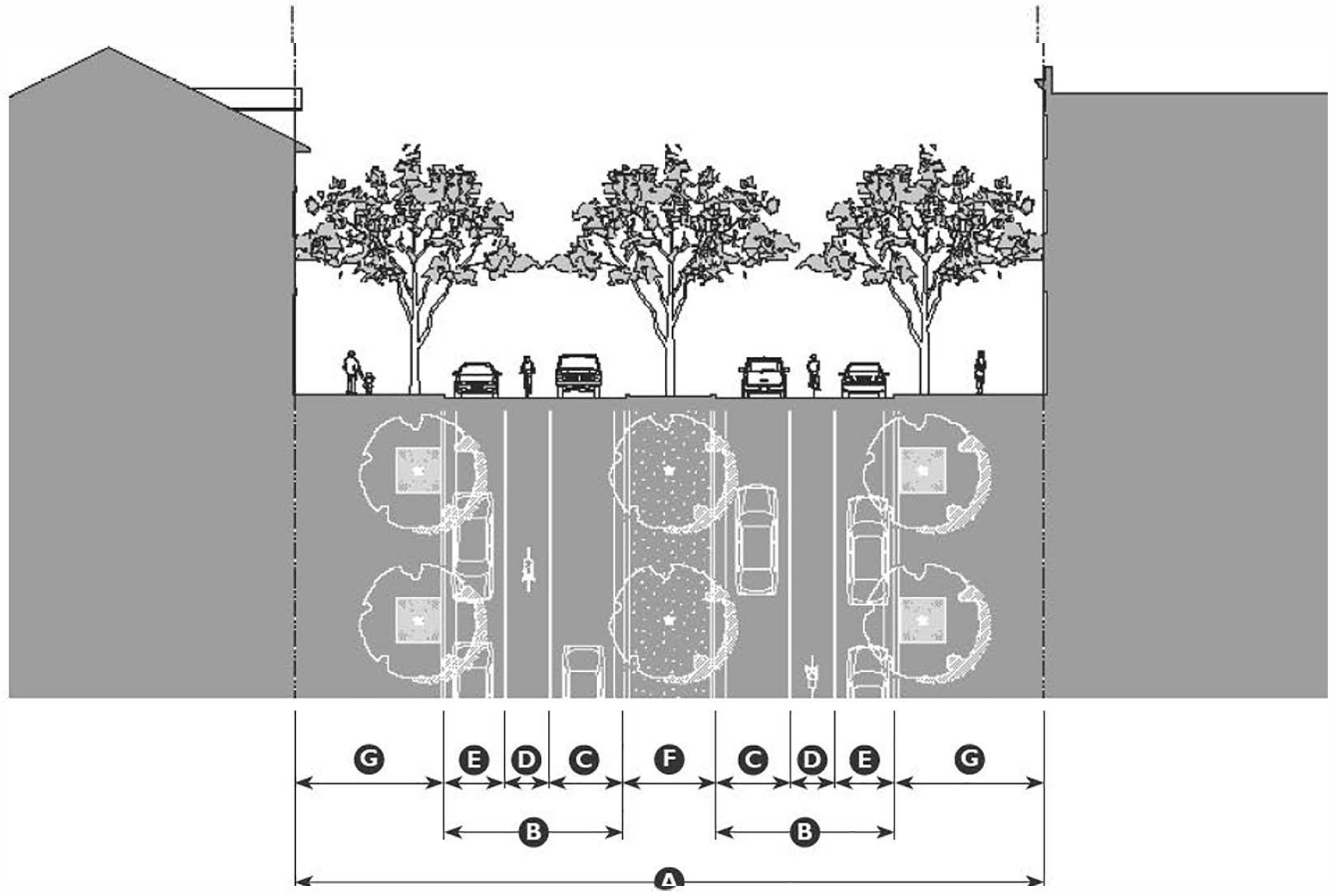
| Application | ||
| Transect Zones | T4MS, T5MSF, T5MS | |
| Movement Type | Low | |
| Design Speed | 30 mph | |
| Overall Widths | ||
| Right-of-Way (ROW) Width | 100' | |
| Pavement Width | 24' | |
| Lane Assembly | ||
| Traffic Lanes | 2@10' | |
| Bicycle Lanes | 2@6' | |
| Parking Lanes | 2@8', marked | |
| Medians | 12' | |
| Public Frontage Assembly | ||
| Frontage Type | Commercial Street | |
| Drainage Collection Type | Curb and Gutter | |
| Planter Type | 4'×4' Tree Well | |
| Landscape Type | Trees at 30' o.c. avg. | |
| Lighting Type | Post, Column, or Double Column | |
| Walkway Type | 20' sidewalk | |
| Curb Type | Square | |
Table 11-61-8.D: Thoroughfare Assembly DR-100-36
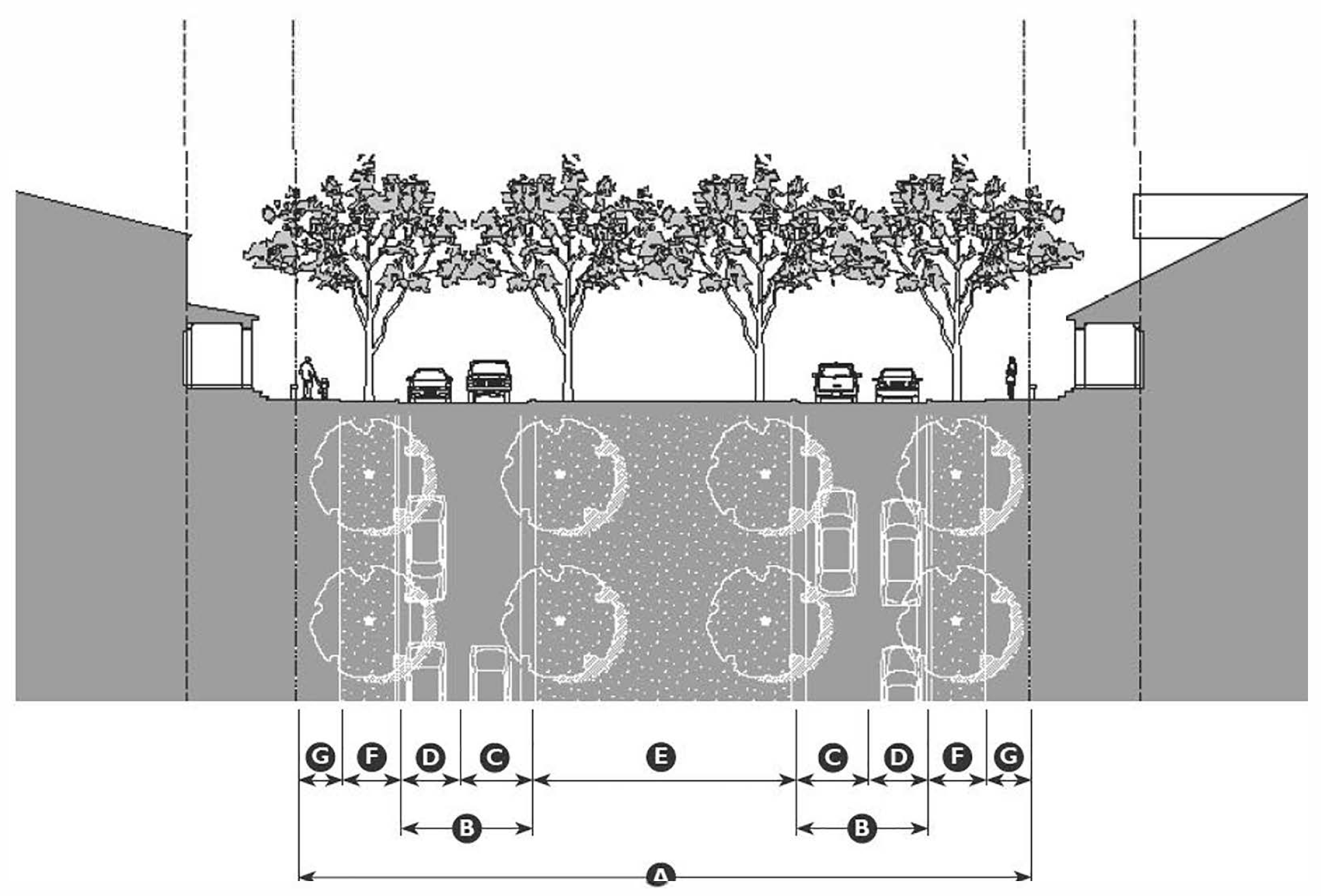
| Application | ||
| Transect Zones | T3N, T4N, T4NF, T5N | |
| Movement Type | Low | |
| Design Speed | 30 mph | |
| Overall Widths | ||
| Right-of-Way (ROW) Width | 100' | |
| Pavement Width | 18' | |
| Lane Assembly | ||
| Traffic Lanes | 2@10' | |
| Bicycle Lanes | None | |
| Parking Lanes | 2@8', marked | |
| Medians | 36' | |
| Public Frontage Assembly | ||
| Frontage Type | Drive | |
| Drainage Collection Type | Curb and Gutter | |
| Planter Type | 8' continuous planter 1 | |
| Landscape Type | Trees at 30' o.c. avg. | |
| Lighting Type | Post, Pipe, Column, or Double Column | |
| Walkway Type | 6' sidewalk 1 | |
| Curb Type | ||
| Along planter | Square | |
| Along median | Rolled 2 | |
| 1 7' Continuous planter and 7' Sidewalk for T5 Application | ||
| 2 Median curbs must be mountable in order to meet requirements for fire/emergency access. | ||
Table 11-61-8.E: Thoroughfare Assembly CS-60-32
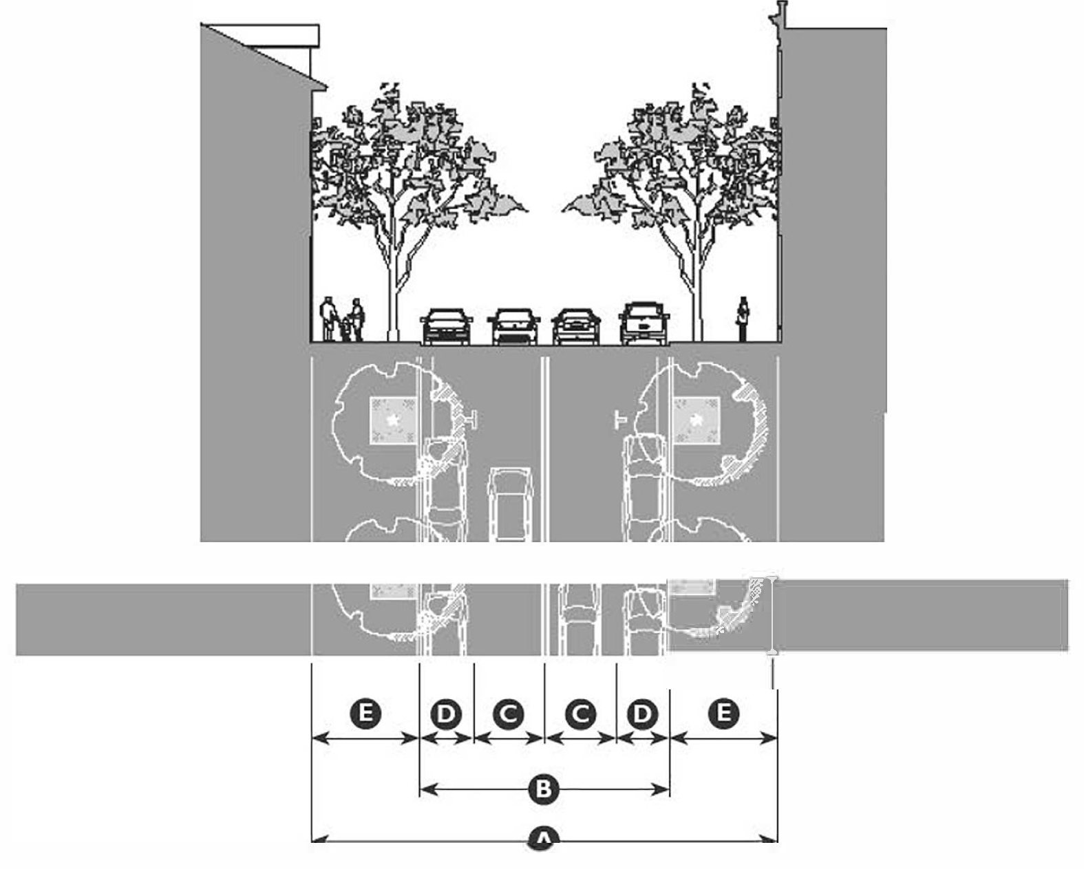
| Application | ||
| Transect Zones | T4MS, T5MSF, T5MS | |
| Movement Type | Slow | |
| Design Speed | 20 mph | |
| Overall Widths | ||
| Right-of-Way (ROW) Width | 60' | |
| Pavement Width | 32' | |
| Lane Assembly | ||
| Traffic Lanes | 2@9' | |
| Bicycle Lanes | None | |
| Parking Lanes | 2@7', marked | |
| Medians | None | |
| Public Frontage Assembly | ||
| Frontage Type | Commercial Street | |
| Drainage Collection Type | Curb and Gutter | |
| Planter Type | 4'×4' tree well | |
| Landscape Type | Trees at 30' o.c. avg. | |
| Lighting Type | Post or Column | |
| Walkway Type | 14' sidewalk | |
| Curb Type | Square | |
Table 11-61-8.F: Thoroughfare Assembly CS-60-34
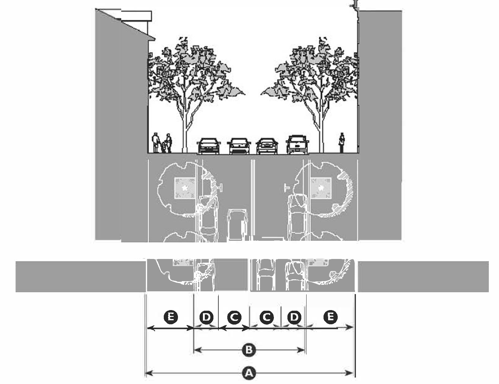
| Application | ||
| Transect Zones | T4MS, T5MSF, T5MS | |
| Movement Type | Slow | |
| Design Speed | 25 mph | |
| Overall Widths | ||
| Right-of-Way (ROW) Width | 60' | |
| Pavement Width | 34' | |
| Lane Assembly | ||
| Traffic Lanes | 2@10' | |
| Bicycle Lanes | None | |
| Parking Lanes | 2@7', marked | |
| Medians | None | |
| Public Frontage Assembly | ||
| Frontage Type | Commercial Street | |
| Drainage Collection Type | Curb and Gutter | |
| Planter Type | 4'×4' tree well | |
| Landscape Type | Trees at 30' o.c. avg. | |
| Lighting Type | Post or Column | |
| Walkway Type | 13' sidewalk | |
| Curb Type | Square | |
Table 11-61-8.G: Thoroughfare Assembly CS-60-36
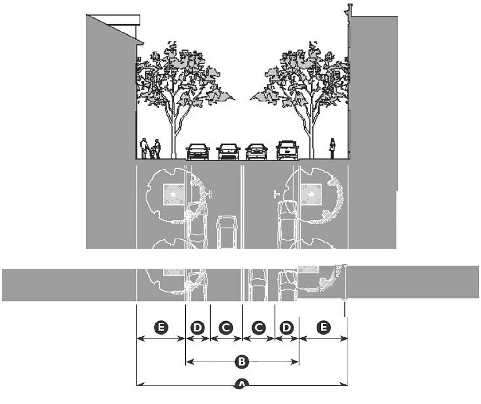
| Application | ||
| Transect Zones | T4MS, T5MSF, T5MS | |
| Movement Type | Low | |
| Design Speed | 30 mph | |
| Overall Widths | ||
| Right-of-Way (ROW) Width | 60' | |
| Pavement Width | 36' | |
| Lane Assembly | ||
| Traffic Lanes | 2@10' | |
| Bicycle Lanes | None | |
| Parking Lanes | 2@8', marked | |
| Medians | None | |
| Public Frontage Assembly | ||
| Frontage Type | Commercial Street | |
| Drainage Collection Type | Curb and Gutter | |
| Planter Type | 4'×4' tree well | |
| Landscape Type | Trees at 30' o.c. avg. | |
| Lighting Type | Post or Column | |
| Walkway Type | 12' sidewalk | |
| Curb Type | Square | |
Table 11-61-8.H: Thoroughfare Assembly CS-60-32
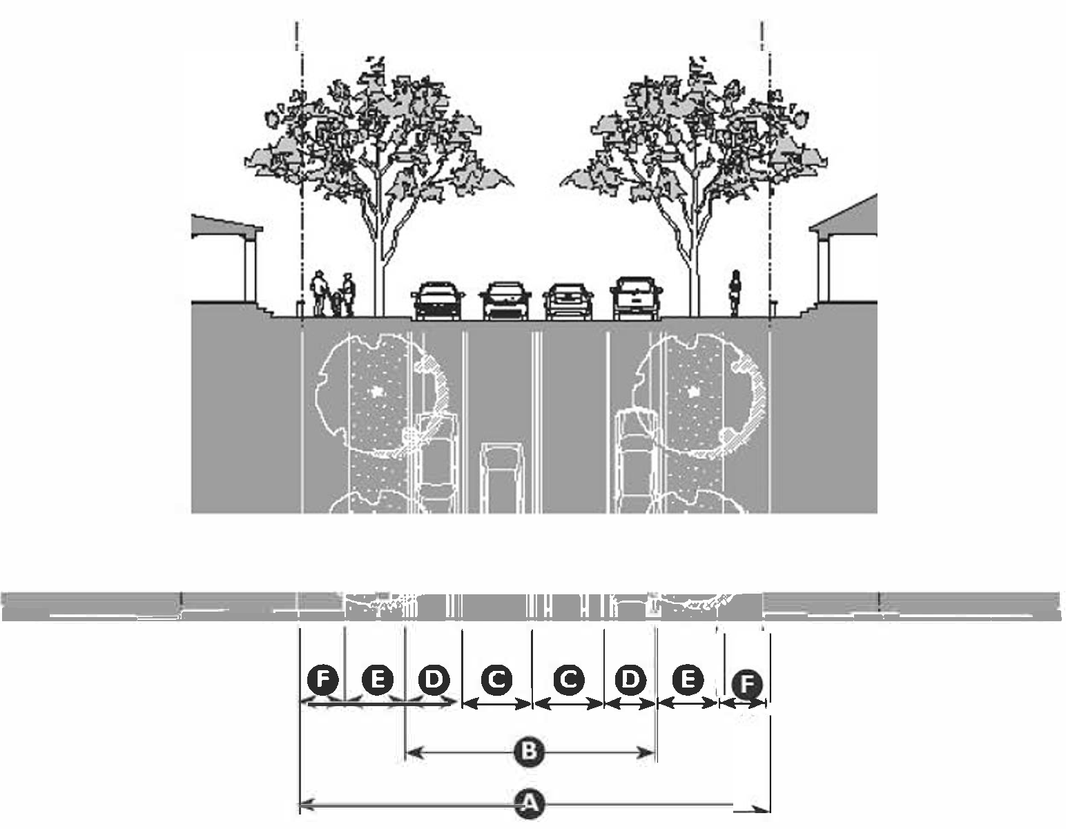
| Application | ||
| Transect Zones | T3N, T4N, T4NF, T5N | |
| Movement Type | Slow | |
| Design Speed | 20 mph | |
| Overall Widths | ||
| Right-of-Way (ROW) Width | 60' | |
| Pavement Width | 32' | |
| Lane Assembly | ||
| Traffic Lanes | 2@9' | |
| Bicycle Lanes | None | |
| Parking Lanes | 2@7', marked | |
| Medians | None | |
| Public Frontage Assembly | ||
| Frontage Type | Street | |
| Drainage Collection Type | Curb and Gutter | |
| Planter Type | 8' continuous planter 1 | |
| Landscape Type | Trees at 30' o.c. avg. | |
| Lighting Type | Pipe, Post or Column | |
| Walkway Type | 6' Sidewalk 1 | |
| Curb Type | Square | |
| 1 7' Continuous planter and 7' Sidewalk for T5 Application | ||
Table 11-61-8.I: Thoroughfare Assembly ST-60-34
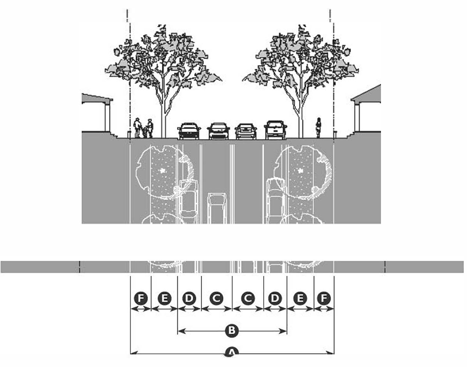
| Application | ||
| Transect Zones | T3N, T4N, T4NF, T5N | |
| Movement Type | Slow | |
| Design Speed | 25 mph | |
| Overall Widths | ||
| Right-of-Way (ROW) Width | 60' | |
| Pavement Width | 34' | |
| Lane Assembly | ||
| Traffic Lanes | 2@10' | |
| Bicycle Lanes | None | |
| Parking Lanes | 2@7', marked | |
| Medians | None | |
| Public Frontage Assembly | ||
| Frontage Type | Street | |
| Drainage Collection Type | Curb and Gutter | |
| Planter Type | 7' continuous planter 1 | |
| Landscape Type | Trees at 30' o.c. avg. | |
| Lighting Type | Pipe, Post or Column | |
| Walkway Type | 6' Sidewalk 1 | |
| Curb Type | Square | |
| 1 6' Continuous planter and 7' Sidewalk for T5 Application | ||
Table 11-61-8.J: Thoroughfare Assembly ST-60-36
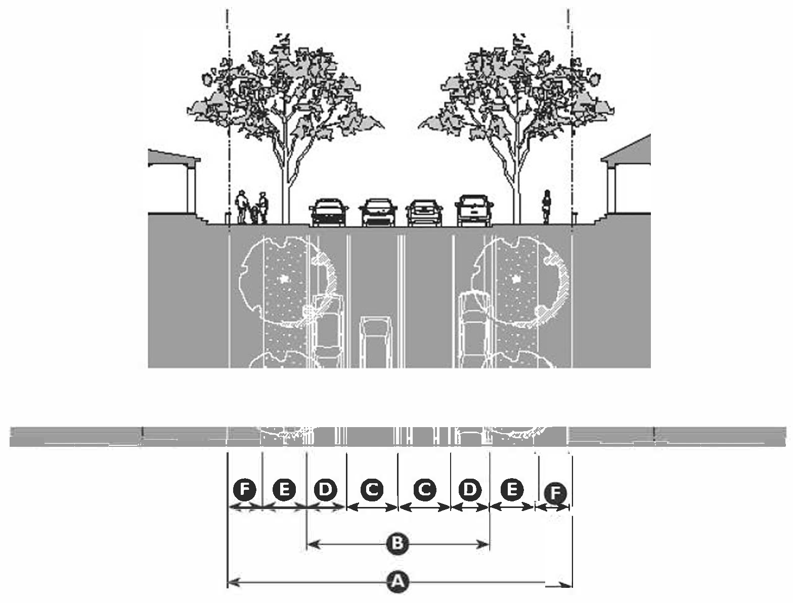
| Application | ||
| Transect Zones | T3N, T4N, T4NF, T5N | |
| Movement Type | Low | |
| Design Speed | 30 mph | |
| Overall Widths | ||
| Right-of-Way (ROW) Width | 60' | |
| Pavement Width | 36' | |
| Lane Assembly | ||
| Traffic Lanes | 2@10' | |
| Bicycle Lanes | None | |
| Parking Lanes | 2@8', marked | |
| Medians | None | |
| Public Frontage Assembly | ||
| Frontage Type | Street | |
| Drainage Collection Type | Curb and Gutter | |
| Planter Type | 6' continuous planter 1 | |
| Landscape Type | Trees at 30' o.c. avg. | |
| Lighting Type | Pipe, Post or Column | |
| Walkway Type | 6' Sidewalk 1 | |
| Curb Type | Square | |
| 1 5' Continuous planter and 7' Sidewalk for T5 Application | ||
Table 11-61-8.K: Thoroughfare Assembly ST-40-26
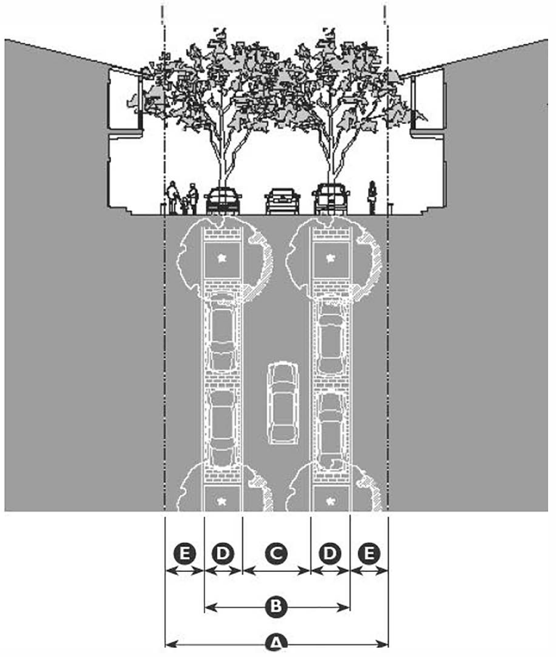
| Application | ||
| Transect Zones | T3N, T4N, T4NF | |
| Movement Type | Yield | |
| Design Speed | <20 mph | |
| Overall Widths | ||
| Right-of-Way (ROW) Width | 40' | |
| Pavement Width | 26' | |
| Lane Assembly | ||
| Traffic Lanes | 1@12' | |
| Bicycle Lanes | None | |
| Parking Lanes | 2@7', marked | |
| Medians | None | |
| Public Frontage Assembly | ||
| Frontage Type | Street | |
| Drainage Collection Type | Valley Gutter or Sheet Flow | |
| Planter Type | 6'×6' planter at 50' o.c. | |
| Landscape Type | Trees at 50' o.c. avg. | |
| Lighting Type | Post or Column | |
| Walkway Type | 7' Sidewalk | |
| Curb Type | Rolled or flush | |
Table 11-61-8.L: Thoroughfare Assembly RL-20-12
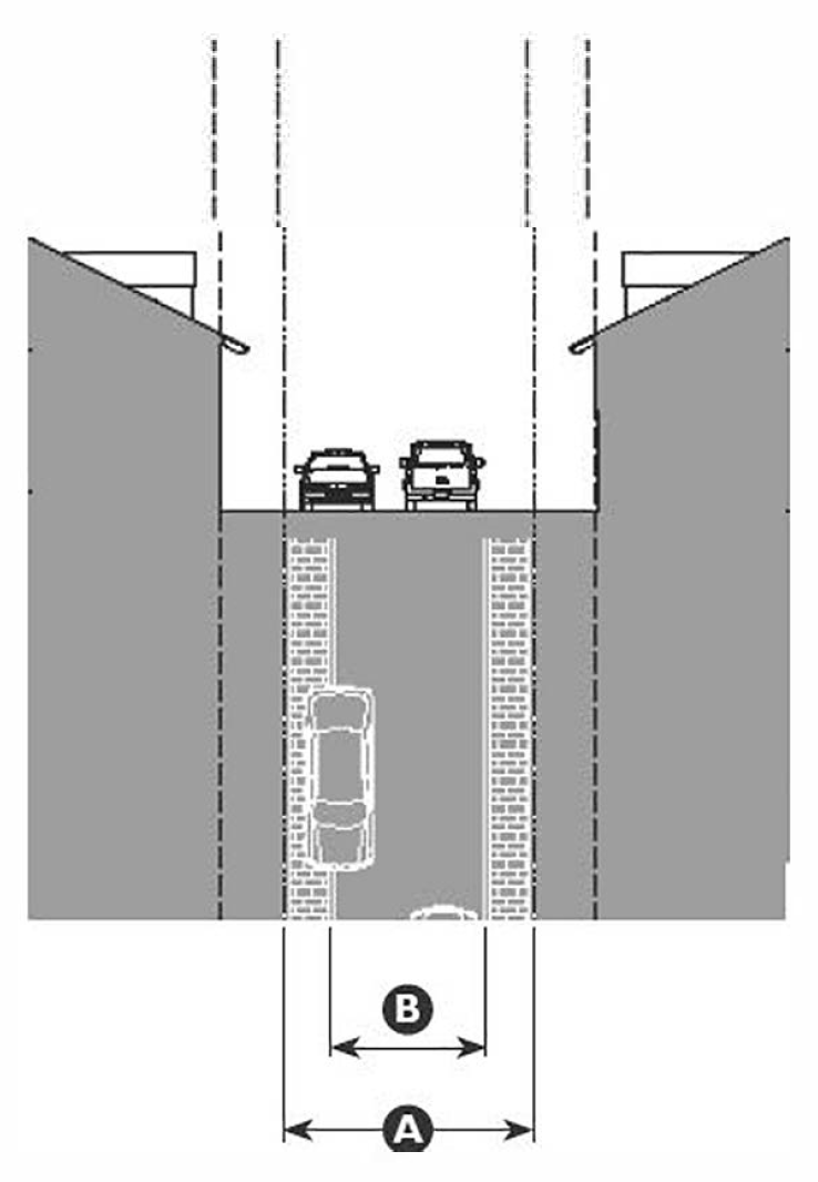
| Application | ||
| Transect Zones | T3N, T4N, T4NF | |
| Movement Type | Yield | |
| Design Speed | <20 mph | |
| Overall Widths | ||
| Right-of-Way (ROW) Width | 40' | |
| Pavement Width | 12' | |
| Lane Assembly | ||
| Traffic Lanes | 1@12' | |
| Bicycle Lanes | None | |
| Parking Lanes | None | |
| Medians | None | |
| Public Frontage Assembly | ||
| Frontage Type | Rear Lane | |
| Drainage Collection Type | Valley Gutter or Sheet Flow | |
| Planter Type | None | |
| Landscape Type | None | |
| Lighting Type | Pipe or Post (if provided) | |
| Walkway Type | None | |
| Curb Type | Rolled or flush | |
Table 11-61-8.M: Thoroughfare Assembly RA-24-21
| Application | ||
| Transect Zones | T4MS, T5N, T5MSF, T5MS, T6MS | |
| Movement Type | Slow | |
| Design Speed | <20 mph | |
| Overall Widths | ||
| Right-of-Way (ROW) Width | 24' | |
| Pavement Width | 21' | |
| Lane Assembly | ||
| Traffic Lanes | 2@10'6" | |
| Bicycle Lanes | None | |
| Parking Lanes | None | |
| Medians | None | |
| Public Frontage Assembly | ||
| Frontage Type | Rear Alley | |
| Drainage Collection Type | Valley Gutter or Sheet Flow | |
| Planter Type | None | |
| Landscape Type | None | |
| Lighting Type | Pipe or Post (if provided) | |
| Walkway Type | None | |
| Curb Type | Rolled or flush | |
11-61-9: - THOROUGHFARE FORMULAS AND COMPONENTS
A.
This section provides thoroughfare components that have been approved by the Planning Department, City Traffic Engineer, Fire Department, Solid Waste, and City Engineer for use in transect zones.
B.
The tables in this section are added into the City of Mesa Engineering and Design Standards.
Table 11-61-9.A: Thoroughfare Formulas
 | |||||||
| Movement Type | Speed | Lane Assembly | Public Frontage Assembly | ||||
| Travel Lanes | Parking Lanes | Planting min. | Walkway min. | Assembly min. | Edge Treatment | ||
| T1 and T2 Allowed Movement Types | Speed | Lane Assembly | Public Frontage Assembly | ||||
| Travel Lanes | Parking Lanes | Planting 1 min. | Walkway 1 min. | Assembly min. | Edge Treatment | ||
| Slow: 20 | 20 mph | 9' | - | 5' | 5' | 13' | R or C |
| Slow: 25 | 25 mph | 10' | - | 5' | 5' | 13' | R or C |
| Low: 30 | 30 mph | 10' | - | 5' | 5' | 13' | R or C |
| Low: 35 | 35 mph | 11' | - | 5' | 5' | 13' | R or C |
| T3 Allowed Movement Types | Speed | Lane Assembly | Public Frontage Assembly | ||||
| Travel Lanes | Parking 1 Lanes | Planting min. | Walkway min. | Assembly min. | Edge Treatment | ||
| Yield | <20 mph | 12' | 7' | 5' | 5' | 10' | C |
| Yield: Rear Lane | 10 mph | 12' | - | - | - | 4' | R, C, or RB |
| Slow: 20 | 20 mph | 9' | 7' | 5' | 5' | 10' | C |
| Slow: 25 | 25 mph | 10' | 7' | 5' | 5' | 10' | C |
| Low: 30 | 30 mph | 10' 2 | 8' | 5' | 5' | 10' | C |
| T4 Allowed Movement Types | Speed | Lane Assembly | Public Frontage Assembly | ||||
| Travel Lanes | Parking Lanes | Planting 1 min. | Walkway min. | Assembly min. | Edge Treatment | ||
| Yield | <20 mph | 12' | 7' | 5' | 6' | 11' | C |
| Yield: Rear Lane | 10 mph | 12' | - | - | - | 4' | R, C, or RB |
| Yield: Alley | 10 mph | 21' | - | - | - | 1.5' | RB |
| Slow: 20 | 20 mph | 9' | 7' | 5' | 6' | 12' | C |
| Slow: 20 w/45° angle parking | 20 mph | 12' | 16'/18' 3 | 5' | 6' | 12' | C |
| Slow: 25 | 25 mph | 10' | 7' | 5' | 6' | 12' | C |
| Slow: 25 w/45° angle parking | 25 mph | 12'/10' 4 | 16'/18' 3 | 5' | 6' | 12' | C |
| Low: 30 | 30 mph | 10' 2 | 8' | 5' | 6' | 12' | C |
| T5 Allowed Movement Types | Speed | Lane Assembly | Public Frontage Assembly | ||||
| Travel Lanes | Parking Lanes | Planting 1 min. | Walkway min. | Assembly min. | Edge Treatment | ||
| Yield: Alley | 10 mph | 21' | - | - | - | 1.5' | RB |
| Slow: 20 | 20 mph | 9' | 7' | 5' | 7' | 12' | C |
| Slow: 20 w/45° angle parking | 20 mph | 12' | 16'/18' 3 | 5' | 7' | 12' | C |
| Slow: 25 | 25 mph | 10' | 7' | 5' | 7' | 12' | C |
| Slow: 25 w/45° angle parking | 25 mph | 10'/12' 4 | 16'/18' 3 | 5' | 7' | 12' | C |
| Low: 30 | 30 mph | 10' 2 | 8' | 5' | 7' | 12' | C |
| Low: 35 | 35 mph | 11' | 8' | 5' | 7' | 12' | C |
| T6 Allowed Movement Types | Speed | Lane Assembly | Public Frontage Assembly | ||||
| Travel Lanes | Parking Lanes | Planting 1 min. | Walkway min. | Assembly min. | Edge Treatment | ||
| Yield: Alley | 10 mph | 21' | - | - | - | 1.5' | RB |
| Slow: 20 | 20 mph | 9' | 7' | - | 12' | 12' | C |
| Slow: 20 w/45° angle parking | 20 mph | 12' | 16'/18' 3 | - | 12' | 12' | C |
| Slow: 25 | 25 mph | 10' | 7' | - | 12' | 12' | C |
| Low: 30 | 30 mph | 10' 2 | 8' | - | 12' | 12' | C |
| Low: 35 | 35 mph | 11' | 8' | - | 12' | 12' | C |
| End Notes | |||||||
| 1 If provided. | |||||||
| 2 11' wide travel lanes adjacent to a median for assemblies with a median separating multiple travel lanes in each direction. | |||||||
| 3 16' min. for reverse angled parking; 18' min. for head-in angled parking. | |||||||
| 4 25 mph design speed requires 2 lanes in each direction with 12' outside travel lanes (adjacent to angled parking) and 10' inside travel lanes | |||||||
| Key - = Not Allowed R = Rural Edge Treatment C = Curb Edge Treatment RB = Ribbon Curb (18") | |||||||
Table 11-61-9.B: Vehicular Lane Assemblies
| Movement Type | Yield | Slow | Slow | Low | Low |
|---|---|---|---|---|---|
| Design Speed | <20 MPH | 20 MPH | 25 MPH | 30 MPH | 35 MPH |
| No Parking |  |  |  |  |  |
| No Parking |  |  |  | ||
| Limited Parking |  | ||||
| One-Side Parking |  |  |  | ||
| Two-Side Parking |  |  |  |  | |
| Angle Parking | 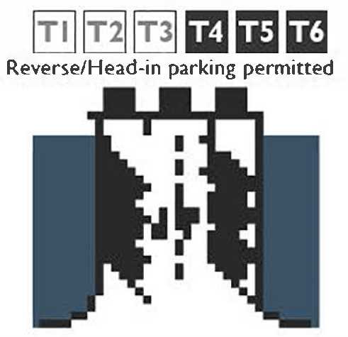 | 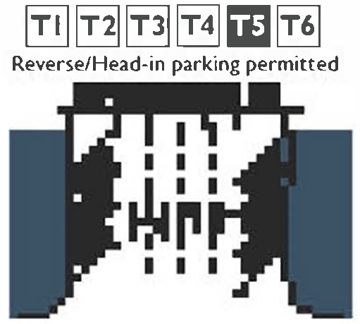 | |||
| Medians With Parking |  |  | |||
| Medians With Parking |  | 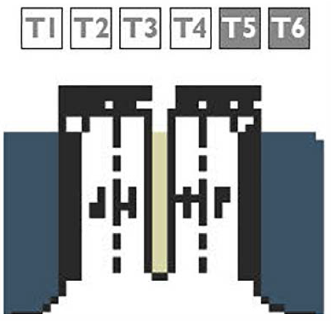 | |||
| Medians With Parking | 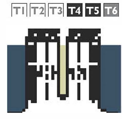 |  | |||
| Medians With Angled Parking | 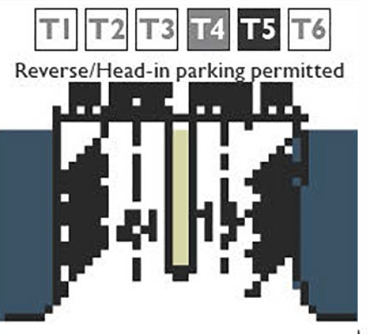 |
| Table 11-61-9.C: Bicycle FacilitiesStandards | |
| Class I: Multi-Use Trail | |
| Transect Zones | |
| Movement Types | Slow, Low |
| Width | |
| One-way | 10' min. |
| Two-way | 12' min. |
| Class II: Bicycle Lane | |
| Transect Zones | |
| Movement Types | Slow, Low 1 |
| Width Adjacent to: | |
| Rural Edge | 5' min. |
| Parking | 6' min. |
| Curb and Gutter | 5½' to face of curb |
| Class III: Shared Lanes/Bicycle Boulevard | |
| Transect Zones | |
| Movement Types | Yield, Slow |
| Width | no minimum |
| 1 Bicycle Lanes on Thoroughfares with a design speed >30 mph are allowed By Review only. | |
| Table 11-61-9.D: Curb Radius | ||
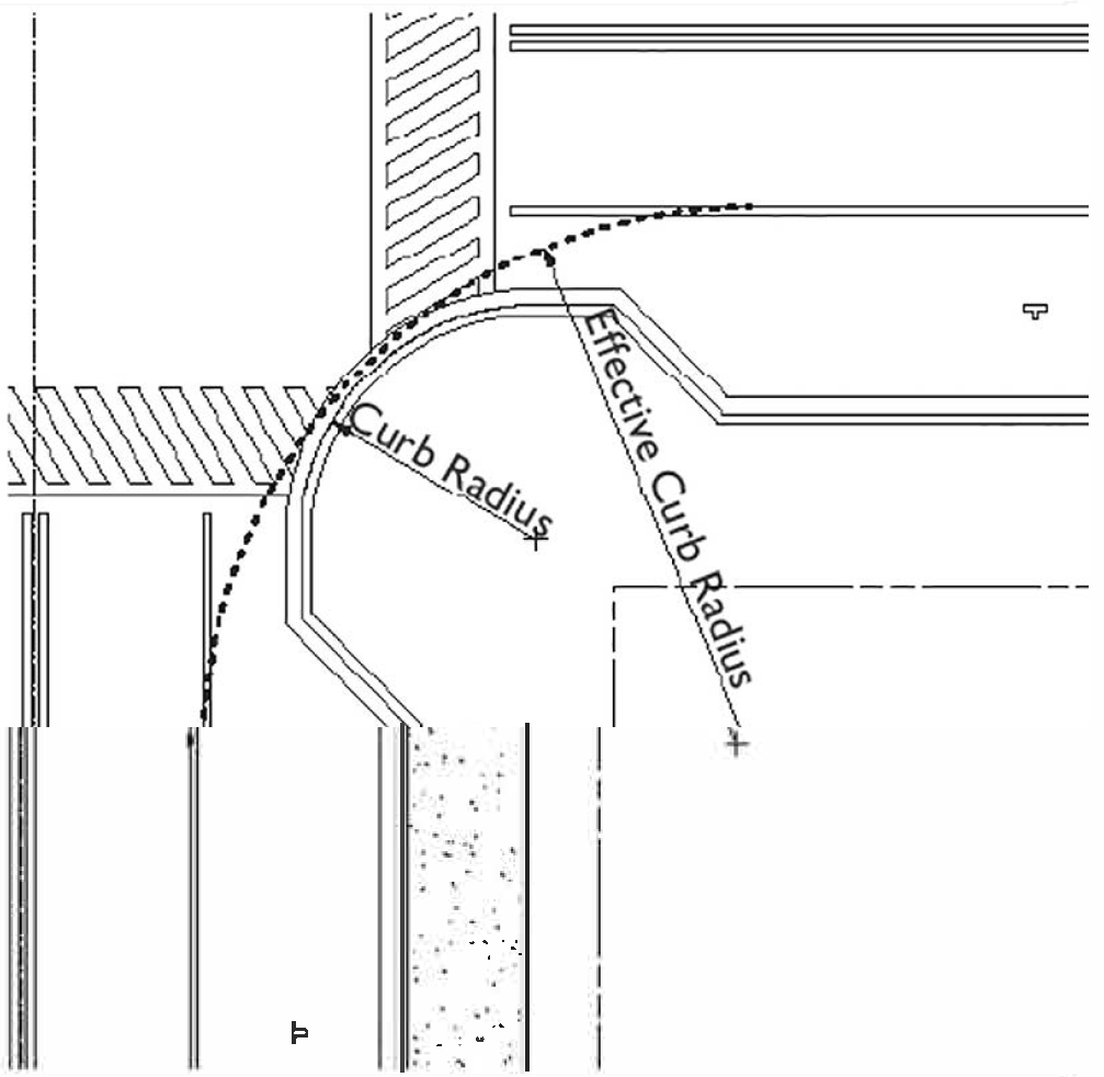 | ||
| Movement Type | Speed | Curb Radius1 |
| Yield | <20 mph | 5'—10' |
| Slow | 20—25 mph | 10'—15' |
| Low | 30—35 mph | 15'—20' |
| 1 This table provides the allowed curb radius range by movement type and speed. The dimensions above require the provision of an effective curb radius and/or mountable curbs that meet the needs of fire and emergency access. All intersections shall be designed to meet the requirements in 11-61-6 (Intersections) | ||
| Table 11-61-9.E: Public Frontage Types | ||
| The public frontage is the area between the curb of the vehicular lanes and the Property Line/ROW. Dimensions are provided in Table F (Public Frontage Standards). | ||
| Public Frontage Type |  | Transect Zone |
| (HW) For Highway. The For Highway Frontage has bicycle trails, no parking and open swales. The landscaping consists of the natural condition or multiple species arrayed in naturalistic clusters. Buildings are buffered by distance or berms. | 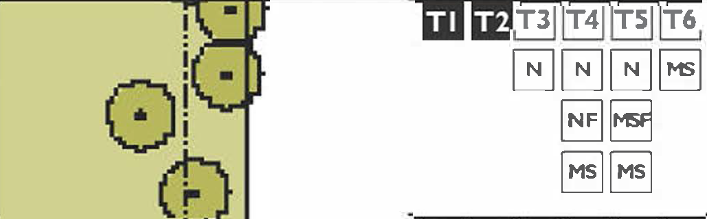 | |
| (RD) For Road. The For Road Frontage has open swales, a walking path or bicycle trail along one or both sides, and yield parking. The landscaping consists of multiple species arrayed in naturalistic clusters. | 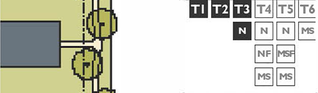 | |
| (ST) For Street. The For Street Frontage has raised curbs drained by inlets and sidewalks separated from the vehicular lanes by individual or continuous planters. The landscaping consists of street trees of a single or alternating species aligned in a regularly spaced allee. |  | |
| (DR) For Drive. The For Drive Frontage has raised curbs drained by inlets and a wide sidewalk or paved path along one side, related to a Civic Space. It is separated from the vehicular lanes by individual or continuous planters. The landscaping consists of street trees of a single or alternating species aligned in a regularly spaced allee. |  | |
| (AV) For Avenue. The Avenue Frontage has raised curbs drained by inlets and wide sidewalks separated from the vehicular lanes by a narrow continuous planter with parking on both sides. The landscaping consists of a single tree species aligned in a regularly spaced allee. |  | |
| (CS) For Commercial Street or Avenue. The For Commercial Street or Avenue Frontage has raised curbs drained by inlets and very wide sidewalks along both sides separated from the vehicular lanes by separate tree wells with grates. The landscaping consists of a single tree species aligned with regular spacing where possible. |  | |
| (BV) For Boulevard. The Boulevard Frontage has slip roads on both sides. It consists of raised curbs drained by inlets and sidewalks along both sides, separated from the vehicular lanes by planters. The landscaping consists of double rows of a single tree species aligned in a regularly spaced allee. |  | |
| (RA) For Rear Alley. The Rear Alley Frontage is located to the rear of lots. It consists of a paved surface and ribbon curb at the edges adjacent to property lines or buildings. Alleys are typically not landscaped. |  | |
| (RL) For Rear Lane. The Rear Lane Frontage is located to the rear of lots. It consists of a paved surface and compacted gravel or similar material placed on the outer edges. Lanes are typically not landscaped. | 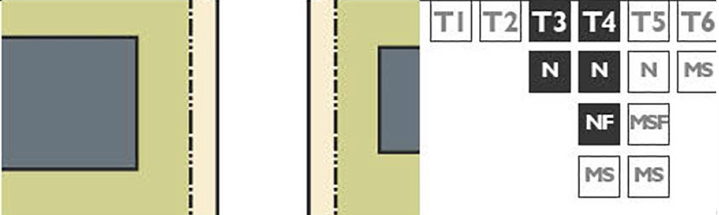 | |
| Table 11-61-9.F Public Frontage Standards | ||||||
| This table assembles prescriptions and dimensions for the public frontage elements - curbs, walkways, and planters - relative to specific frontage types within transect zones. The Assembly row assembles all of the elements for the various frontage types. | ||||||
| Transect Zone | ||||||
| Public Frontage Type | HW-RD-ST | RD-ST | ST-DR-AV-BV | ST-DR-AV-BV | CS-DR-AV-BV | CS-DR-AV-BV |
| Assembly: The principal variables are the type and dimension of curbs, walkways, planters and landscape. |  |  |  |  |  | |
| Total Width | 13' - 22' | 13' - 22' | 10' - 17' | 12' - 16' | 12' - 19' | 12' - 30' |
| Curb: The detailing of the edge of the vehicular pavement, incorporating drainage. |  |  |  |  |  |  |
| Type | Rural | Raised Curb | Raised Curb | Raised Curb | Raised Curb | Raised Curb |
| Walkway: The pavement dedicated exclusively to pedestrian activity. |  |  |  |  |  | 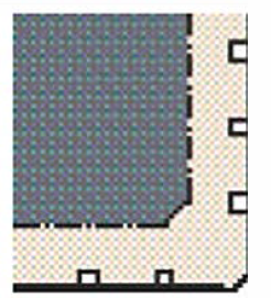 |
| Type | Path (if provided) | Sidewalk | Sidewalk | Sidewalk | Sidewalk | Sidewalk |
| Width | 6' min. | 5' min. | 5' min. | 6' min. | 7' min. | 12' min. |
| Note: the placement of curb ramps shall match the desired path of pedestrian travel. See Mesa Engineering and Design Standards and Standard Details and Specifications for curb ramp design. | ||||||
| Planter: The layer which accommodates street trees and other landscape |  |  |  | 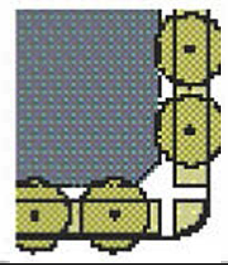 |  |  |
| Arrangement | Clustered | Clustered | Regular | Regular | Regular | Opportunistic |
| Species | Multiple | Multiple | Multiple | Single/Alternating | Single | Single |
| Type | Continuous Planter | Continuous Planter | Continuous Planter | Continuous Planter | Continuous Planter | Tree Well |
| Width | 5' min. | 5' min. | 5' min. | 5' min. | 5' min. | 4' - 6' (tree wells located within Walkway Width) |
| Table 11-61-9.G Public Planting | ||
| This table shows common street tree types and their appropriateness within the transect zones. The "City of Mesa Engineering Design and Construction Standards and Specifications for New Construction" provides detailed specifications for landscaping along thoroughfares. | ||
| Standards | Illustration | Recommended Species |
 | Willow Acacia, Shoestring Acacia, Palo Blanco, Floss-Silk Tree, Indian Rosewood, Red-Cap Gum, Coolibah, Afghan Pine, Canary Island Pine, Mexican Ebony, Tipu Tree | |
|
Tree Shape: Oval
Placement: Spacing 20' - 35' o.c. | ||
 | Leather-Leaf Acacia, Mulga, Fruitless Olive, ironwood, Chinese Pistache | |
|
Tree Shape: Ball
Placement: Spacing 20' - 30' o.c. | ||
 | Palo Brea, Honey Mesquite, Chilean Mesquite, Velvet Mesquite, Screwbean Mesquite, Live Oak, Evergreen Elm | |
|
Tree Shape: Umbrella
Placement: Spacing 20' - 30' o.c. | ||
 | Guajillo, Sweet Acacia, Cascalote, Canyon Hacberry, Blue Palo Verde, Hybrid Palo Verde, Desert Willow, Feather Bush | |
|
Tree Shape: Vase
Placement: Spacing 25' - 35' o.c. | ||
 | Mexican Blue Palm, Mexican Fan Palm, California Fan Palm, Canary Island Date Palm, Texas Sabal Palm, Queen Palm | |
|
Tree Shape: Palm
Placement: Spacing 20' - 30' o.c. | ||
| Note: All Street trees shall be planted and maintained to avoid conflicts with fire/emergency vehicles and have a minimum canopy clearance of 14' at maturity. | ||
| Table 11-61-9.H Public Lighting | |||||
| Lighting varies in brightness and also in the character of the fixture according to the transect zones. This table shows the types of light poles and fixtures allowed within the transect zones. Within these fixture types, the City Traffic Engineer must be included in the selection of light poles and light fixtures. | |||||
| Transect Zone | |||||
| Fixture Type | Cobra Head | Pipe | Post | Column | Double Column |
| Illustration | |||||
11-62-1: - PURPOSE
The purpose of this Chapter is to provide a set of civic space types and their associated standards to use within the transect zones.
11-62-2: - APPLICABILITY
The standards established in this Chapter shall apply to all proposed development within the transect zones, and shall be considered in combination with the standards found within the other Chapters in Article 6 (Form-Based Zoning).
11-62-3: - CIVIC SPACES
A.
The standards established in this Chapter provide the transect zones with a diverse palette of parks and other publicly accessible civic spaces, publicly or privately owned, that are essential components of walkable urban environments.
B.
There are 11 different civic space types defined in Table A (Civic Space Type Standards). Two of the civic space types, Playgrounds and Community Gardens, may be incorporated into any of the other nine types or may stand alone.
C.
In Table A (Civic Space Type Standards), the illustration and description of each civic space type are illustrative in nature and not regulatory.
D.
The service area, size, frontage and disposition of elements standards of each civic space types are regulatory.
1.
Service Area. Describes how the civic space relates to the City as a whole and the area that will be served by the civic space.
2.
Size. The overall range of allowed sizes of the civic space.
3.
Frontage. The relationship along property lines of a civic space to adjacent buildings or lots.
a.
The front of the lots attached to or across a thoroughfare from a civic spaces should face on to the civic space to the maximum extent possible.
b.
Building. Lots that are attached to or across a thoroughfare from civic spaces listed as having an "Building" frontage shall have the front of the lot facing on to the civic space for a minimum of three quarters of the civic space perimeter.
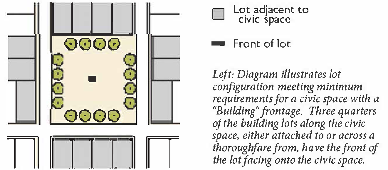
c.
Independent. Lots that are attached to or across a thoroughfare from civic spaces listed as having an "Independent" may have the front, side street, or rear of the lot facing on to the civic space.
4.
Disposition of Elements. The placement of objects within the civic space.
a.
Natural. Civic spaces with natural character are designed in a natural manner with no formal arrangement of elements.
b.
Formal. Civic spaces with a formal character have a more rigid layout that follows geometric forms and has trees and other elements arranged in formal patterns.
c.
Informal. Civic spaces with an informal character have a mix of Formal and Natural characteristics.
E.
Typical Facilities. A list of the typical facilities found within the civic space. This list is not intended to be a complete list of facilities allowed nor is it intended that every civic space would contain each of the facilities listed. Facilities larger than indicated gross square footage (gsf) require review and approval by the Director and Parks Director.
F.
The civic spaces specified in Table A (Civic Space Type Standards) are allowed By Right or By Review in the designated transect zones. (Civic Space allowed By Review are allowed if approved by the Director and Parks Director.)
| Table 11-62-3.A Civic Space Type Standards | |||
| Transect Zone | |||
| Civic Space Type | Regional Park | Sport Complex | Community Park |
| Illustration | 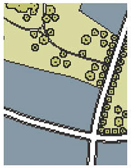 | 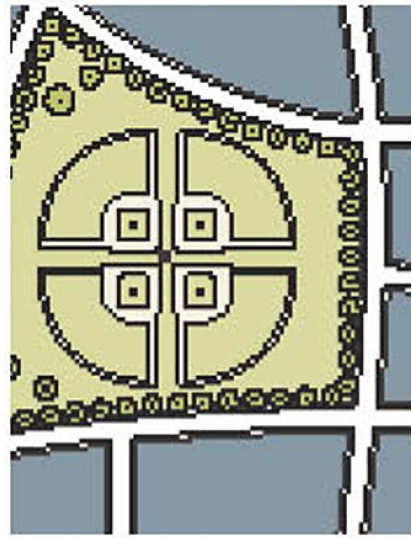 | 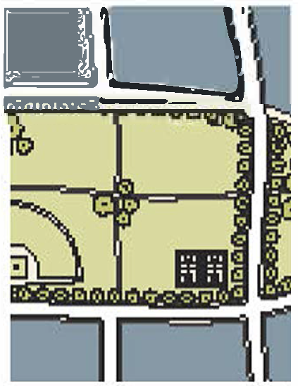 |
| Description | A natural preserve available for unstructured recreation. | An open space that consolidates heavily programmed athletic fields and associated facilities. | An open space available for unstructured recreation and a limited amount of structured recreation. |
| Location and Size | |||
| Location | |||
| Service Area | Regional | Regional | Multiple Neighborhoods |
| Size | |||
| Minimum | 200 acres | 25 acres | 12 acres |
| Maximum | - | - | - |
| Character | |||
| Frontage | Independent | Independent | Independent |
| Disposition of Elements | Natural, Formal or Informal | Formal or Informal | Informal |
| Typical Facilities | |||
| Passive and Active Recreation, Accessory Structure, Drinking Fountains, Community Facility <7,500 gsf, Paths and Trails | Passive and Active Recreation, Accessory Structure, Drinking Fountains, Community Facility <7,500 gsf, Paths and Trails | Passive and Active Recreation, Accessory Structure, Drinking Fountains, Community Facility <5,000 gsf, Paths and Trails | |
| Table 11-62-3.A Civic Space Type Standards (continued) | |||
| Transect Zone | |||
| Civic Space Type | Greenway | Neighborhood Green | Neighborhood Square |
| Illustration | 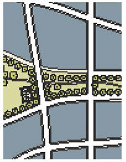 | 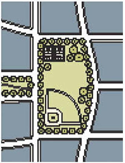 |  |
| Description | A linear open space that may follow natural corridors providing unstructured and limited amounts of structured recreation. | An open space available for unstructured and limited amounts of structured recreation. | An open space available for civic purposes, unstructured and limited amounts of structured recreation. |
| Location and Size | |||
| Location | |||
| Service Area | Multiple Neighborhoods | Neighborhood | Neighborhood |
| Size | |||
| Minimum | 8 acres (60' wide by 1 mile long) | 1 acre | ½ acre |
| Maximum | - | 15 acres | 5 acres |
| Character | |||
| Frontage | Independent or Building | Building | Building |
| Disposition of Elements | Natural or Informal | Informal | Formal |
| Typical Facilities | |||
| Passive and Active Recreation, Accessory Structure, Drinking Fountains, Community Facility <5,000 gsf, Paths and Trails | Passive and Active (unstructured or structured) Recreation, Accessory Structure, Drinking Fountains, Community Facility <5,000 gsf, Paths and Trails | Passive and Active (unstructured or structured) Recreation, Accessory Structure, Drinking Fountains, Community Facility <5,000 gsf, Paths and Trails | |
| Table 11-62-3.A Civic Space Type Standards (continued) | |||
| Transect Zone | |||
| Civic Space Type | Plaza | Pocket Plaza | Pocket Park |
| Illustration |  |  |  |
| Description | A formal open space available for civic purposes and commercial activities. Plazas are typically hardscaped. Commercial activities shall be subordinate to Civic use. | A formal open space available for civic purposes and commercial activities. Pocket Plazas are typically hardscaped. Commercial activities shall be subordinate to Civic use. | An open space available for informal activities in close proximity to neighborhood residences. |
| Location and Size | |||
| Location | |||
| Service Area | Neighborhood | Neighborhood | Neighborhood |
| Size | |||
| Minimum | ½ acre | 2,000 sf | 2,000 sf |
| Maximum | 2½ acres | ½ acre | 1 acre |
| Character | |||
| Frontage | Building | Building | Building |
| Disposition of Elements | Formal | Formal | Formal or Informal |
| Typical Facilities | |||
| Passive Recreation, Accessory Structure, Drinking Fountains, Paths and Trails | Passive Recreation, Accessory Structure, Drinking Fountains, Paths and Trails | Passive Recreation, Accessory Structure, Drinking Fountains, Paths and Trails | |
| Table 11-62-3.A Civic Space Type Standards (continued) | ||
| Transect Zone |  | |
| Civic Space Type | Playground | Community Garden1 |
| Illustration | 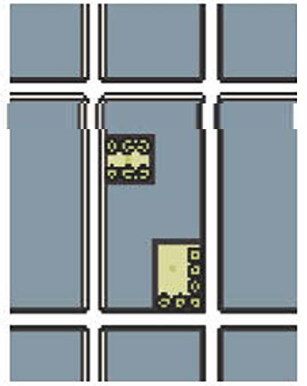 | 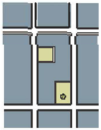 |
| Description | An open space designed and equipped for the recreation of children. A Playground should be fenced and may include an open shelter. Playgrounds may be included within other civic spaces. | An open space designed as a grouping of garden plots that are available to nearby residents for small-scale cultivation. Community Gardens may be included within other civic spaces. |
| Location and Size | ||
| Location | ||
| Service Area | Neighborhood | Neighborhood |
| Size | ||
| Minimum | - | - |
| Maximum | - | - |
| Character | ||
| Frontage | Independent or Building | Independent or Building |
| Disposition of Elements | Formal or Informal | Formal or Informal |
| Typical Facilities | ||
| Accessory Structure, Drinking Fountains, Paths and Trails | Accessory Structure, Drinking Fountains, Paths and Trails | |
| 1 See Section 11-31-10 (Community Gardens) for specific standards. | ||
11-62-4: - ADDITIONAL STANDARDS
A.
Accessory Structure Standards. All accessory structures within parks and open spaces, including, but not limited to, restrooms, open-air pavilions, gazebos, picnic shelters and outdoor theaters, shall not be subject to the physical requirements of the Building Form Standards in Chapter 58 (Building Form Standards). They shall be designed and furnished to be consistent with the character of the transect zone in which they are located. Such consistency may require accessory structures to maintain building setbacks, frontage, massing, disposition and character similar to adjacent development as determined by the Director.
B.
Lighting Standards.
1.
All lighting shall comply with the standards found in the Mesa Lighting and Electrical Code, Title 4, Chapter 4 of the Mesa City Code.
2.
All lighting shall comply with § 11-30-5 of this Zoning Code.
3.
All athletic field/sport court lighting shall be Dark Sky Compliant and shall require a Special Use Permit (SUP).
11-63-1: - PURPOSE
The purpose of this Chapter is to provide standards for the application of Form-Based Code standards to reinforce walkable urban neighborhoods or create new walkable urban neighborhoods within the City of Mesa. This application will start with the downtown Main Street area to reinforce the implementation of light rail and to put a proper regulatory framework in place to encourage transit-oriented development (TOD).
Smart Growth Community Plans (SGCP) are intended to create and reinforce walkable urban environments with a mix of housing, civic, retail and service choices within a compact, walkable, and transit-oriented or transit-ready environment.
This Chapter shall be used to achieve the following goals and objectives:
A.
Improve the built environment and human habitat.
B.
Promote development patterns that support safe, effective, and multi-modal transportation options, including auto, pedestrian, bicycle, and transit, and therefore minimize vehicle traffic by providing for a mixture of land uses, walkability, and compact community form.
C.
Provide neighborhoods with a variety of housing types to serve the needs of a diverse population.
D.
Remove barriers and provide incentives for walkable urban projects.
E.
Promote the greater health benefits of a pedestrian-oriented environment.
F.
Reinforce the character and quality of downtown and adjacent neighborhoods.
G.
Reduce sprawling, auto-dependent development.
H.
Protect and enhance real property values.
I.
Reinforce a unique identity for Mesa that builds upon the local context, climate, and history.
11-63-2: - APPLICABILITY
A.
The owner(s) of a parcel, or abutting parcels, consisting of 10 acres or more of contiguous lots within an area subject to the Smart Growth Overlay may apply to prepare an Infill SGCP. In consultation with the Planning Office, an Infill SGCP must assign transect zones, civic zones, thoroughfares, special districts and/or special requirements as provided in this Chapter, with appropriate transitions to abutting areas.
B.
For a site less than 10 acres or any area designated by the City Council for redevelopment, an Infill SGCP may be approved if the Director determines that:
1.
The goals and objectives of this Chapter can be achieved with the smaller site; or
2.
The project will provide an appropriate and logical extension of an existing transect zone or zones or existing walkable urban environment.
C.
The owner of a parcel, or abutting parcels, consisting of 30 acres or more of contiguous lots, whether inside or outside an area subject to the Smart Growth Overlay, may initiate the preparation of a New Smart Growth Community Plan. The plan shall connect and blend with the scale and character of the surrounding urbanism.
D.
In the event that any of the standards in this Chapter conflict with other standards in this Code the standards in this Chapter override.
11-63-3: - SMART GROWTH COMMUNITY PLAN REQUIREMENTS
Each SGCP shall:
A.
Be structured with pedestrian sheds to determine the scale and center. See Section 11-63-4 (Pedestrian Sheds).
B.
Allocate Transect Zones as per Section 11-63-5 (Transect Zones) and Table 11-63-5.A.
C.
Lay out a thoroughfare network according to standards in Section 11-63-6 (Thoroughfares).
D.
Allocate civic spaces and civic buildings according to the standards in Section 11-63-7 (Civic Buildings and Civic Spaces).
E.
Provide Neighborhood Centers/Main Streets to meet the standards in Section 11-63-8 (Neighborhood Centers/Main Streets).
F.
Provide a mix of building types to meet the standards in Section 11-63-9 (Mix of Building Types).
G.
Provide a mix of lot sizes to meet the standards in Section 11-63-10 (Mix of Lot Types) and Table 11-63-10.A.
H.
Have all lots facing a vehicular thoroughfare, except that 20% of the lots within each Transect Zone may face a pedestrian passage or a courtyard.
I.
Connect and blend with the scale and character of the surrounding walkable urbanism.
J.
The SGCP shall be calibrated to suit specific topographical, environmental, site layout, and design constraints unique to the site or its location within the City, yet each SGCP will be consistent in terms of structure and content based on the provisions of this Chapter.
K.
In addition to the requirements of this Section, the SGCP should promote the Mesa General Plan, or other applicable plans adopted by the city. This can be measured by the achievement of LEED certification (Leadership in Energy and Environmental Design) by the US Green Building Council, or equivalent, for all residential and mixed-use buildings. Also, LEED-ND certification (Leadership in Energy and Environmental Design for Neighborhood Development) for the SGCP should be pursued.
(Ord. No. 5928, § 24, 2-3-25)
11-63-4: - PEDESTRIAN SHEDS
Pedestrian sheds are useful in planning as they provide an understanding of how far a typical pedestrian might be willing to walk. They are based on the understanding that most people are willing to walk up to five minutes before they will choose to drive and up to ten minutes to a major destination or transit stop. SGCPs use pedestrian sheds to define the boundaries and the relationship of development patterns to create walkable environments.
A.
Pedestrian Sheds shall be centered on a Neighborhood Center or a Main Street.
B.
Types of Pedestrian Sheds.
1.
Standard Pedestrian Shed. A pedestrian shed that is based on a one-quarter mile (1320 feet) radius around a node. Standard pedestrian sheds are useful in planning neighborhoods. See diagram on the following page.
2.
Linear Pedestrian Shed. A pedestrian shed that is based on a one-quarter mile (1320 feet) radius around a series of block lengths. Linear pedestrian sheds are useful in planning neighborhood main streets or neighborhoods with multiple nodes. See diagram on the following page.
3.
Long Pedestrian Shed. A pedestrian shed that is based on a one-half mile (2640 feet) radius around a series of block lengths. Long pedestrian sheds are useful in planning major destinations and downtowns. See diagram on the following page.
C.
Maximum Size of Pedestrian Shed.
1.
Individual standard pedestrian sheds shall be no more than 160 acres.
2.
Linear pedestrian sheds shall be no more than 200 acres. The site or any plan may be smaller than its associated pedestrian shed.
3.
Long pedestrian sheds shall be no more than 510 acres.
D.
Remnants of the site outside the pedestrian sheds shall meet the following requirements:
1.
Remnant areas outside of a pedestrian shed shall be assigned transect zones, civic spaces, or special districts; and
2.
If the remnant areas assigned as T3, T4, and T5 transect zones exceed 35 acres, an additional pedestrian shed shall be created to encompass these remnant areas.
E.
The pedestrian shed shall be mapped on the regulating plan.
11-63-5: - TRANSECT ZONES
A.
General.
1.
Transect Zones established in Chapter 58 (Building Form Standards) shall be used for the regulating plan.
2.
Modifications to Transect Zone Standards After Smart Growth Community Plan Approval.
a.
Administrative Modifications. An Applicant may request administrative modifications to the Transect Zone standards in accordance with Section 11-56-3(G) of this Ordinance.
b.
City Council approved modifications. Any modification to a Transect Zone standard that does not qualify as an administrative modification shall be processed as an amendment to the approved Smart Growth Community Plan and is subject to City Council approval.
B.
Allocation of Transect Zones.
1.
Any portion of a development site within one-quarter mile of a major transit stop may be considered transit-oriented development (TOD). Any sites outside this radius shall be considered a traditional neighborhood development (TND).
2.
Community plans for complete new neighborhoods and smaller infill sites over 10 acres shall assign and map transect zones to each pedestrian shed according to the percentages allocated in the table on the following page.
3.
For sites 10 acres or less, the Director shall determine the appropriate mix of Transect Zones and the location of the center of the pedestrian shed for the area to determine if a main street is needed on the site based on existing conditions. For these sites, property owners shall submit a letter of intent to apply a regulating plan to their site to the Director, and a Pre-Application Meeting shall be held prior to Preliminary Review. Following this meeting and the further review of the project area, the Director shall make this determination.
a.
The criteria for determining the appropriate mix of Transect Zones are as follows:
(1)
Proximity to existing or future transit stops;
(2)
Scale and uses adjacent to site;
(3)
Existing zoning and entitlement of property;
(4)
Size of the site;
(5)
Site constraints and opportunities;
(6)
Ability of site to create a complete walkable neighborhood; and/or
(7)
Role of this site in Smart Growth strategy for the larger city based on sector mapping or macro scale analysis.
4.
Any TOD frontage along main streets shall have a T4 or T5 Main Street zone designation.
5.
The Director may approve a variance for up to 15% for the transect zone allocation within Table 11-63-5.A (Required Allocation Mix of Transect Zones) as long as the proposed regulating plan meets the objectives of this Chapter.
(Ord. No. 5948, § 2, 7-1-25)
11-63-6: - THOROUGHFARES
Thoroughfares define the public streets that refine pedestrian sheds into walkable environments. Care should be taken in the layout and sizing of thoroughfares, as wide thoroughfares and a lack of connectivity reduce the pedestrian friendliness of the area.
A.
Design.
1.
Thoroughfares shall be designed per Chapter 61 (Thoroughfare Standards).
2.
The thoroughfare network shall be mapped on a Street Regulating Plan that shall:
a.
Indicate the layout of thoroughfares and the block network according to the standards established in Subsections 11-63-6.B (Block Size) and 11-63-6.C (Connectivity); and
b.
Be reviewed and approved by the Director, City Traffic Engineer, and Fire Department.
3.
Thoroughfares that pass from one transect zone to another shall adjust their public frontages to match the character of the transect zone. For example a thoroughfare that goes from an urban transect zone with retail shops may change in character from wide sidewalks with trees in tree grates to a narrower sidewalk with a planting strip as the thoroughfare transitions to a less urban transect zone composed of various residential building types.
B.
Block Size. Individual block faces and the total block perimeter shall follow the standards established in the table below. If a block contains multiple transect zones, the most intense transect zone shall be used to establish the requirements for block size.
C.
Connectivity.
1.
Interconnected Thoroughfares. Proposed thoroughfares shall be interconnected and shall connect with adjacent thoroughfares external to the site to provide multiple routes for pedestrian and vehicle trips from, to, and within the site.
2.
Thoroughfares shall terminate/connect to other thoroughfares. Thoroughfares shall not terminate on alleys and lanes.
3.
Thoroughfare Extensions and Thoroughfare Stubs.
a.
Where a plan adjoins non-subdivided land, thoroughfares shall be extended to the adjacent non-subdivided land, as prescribed by the maximum block length requirements to provide access to the non-subdivided land in the event of its future subdivision.
b.
Where a plan adjoins developed or entitled parcels, thoroughfares shall connect to existing or entitled thoroughfare right-of-ways and stubs.
4.
Dead-End Thoroughfares and Cul-de-Sacs.
a.
Thoroughfares shall not include dead-end thoroughfares or cul-de-sacs except where through-streets cannot be provided because of an environmental feature requiring protection and/or preservation (e.g., a creek channel).
b.
The length of dead-end thoroughfares shall not exceed 300 feet, as measured from the center of the closest intersection to the center of the cul-de-sac bulb, and these thoroughfares shall provide a suitable turn-around designed to the satisfaction of the Director.
11-63-7: - CIVIC BUILDINGS AND CIVIC SPACES
Civic buildings and civic spaces provide important gathering places for communities and access to outdoor activities. The civic buildings and civic spaces should be carefully located within the pedestrian shed and accessible to all. The following standards shall be met for providing and locating civic buildings and civic spaces.
A.
General.
1.
SGCPs shall designate civic spaces and civic buildings on a Regulating Plan.
2.
The design of civic spaces shall meet the standards set forth in Chapter 62 (Civic Space Types).
3.
Civic buildings and the associated civic spaces shall cover less than 20% of a pedestrian shed. To request that civic buildings and the associated civic spaces cover 20% or more of a pedestrian shed, the applicant may apply for a special exception to create a special district.
B.
Civic Space Allocation.
1.
Projects shall set aside a minimum of five percent of the project area as civic space. This number shall be calculated after street right-of-way are subtracted from the project area. The following are exceptions:
a.
For sites less than four acres, no civic spaces beyond the playground requirements of Subsection 3 are required.
b.
For sites less than eight acres and within 1,500 feet of an existing public park of at least one acre, no civic spaces beyond the playground requirements of Subsection 3 are required.
2.
For sites greater than ten acres, the required amount of civic space shall be distributed throughout the neighborhood as multiple smaller civic spaces.
3.
Each residential lot shall be within 1,500 feet of an existing or proposed publicly accessible playground or tot lot.
C.
Civic Building Allocation.
1.
Sites greater than four acres or providing 100 units or more shall provide an indoor public meeting space that is a minimum of 30 feet by 30 feet and a maximum of 10,000 square feet. This may be a freestanding building or integrated within another building. This requirement may be waived for Infill SGPS if an existing public meeting space is located within 1,500 feet of the site.
2.
Schools that are integrated into the regulating plan shall be located near the designated center of the pedestrian shed.
3.
If a pool and a pool building are integrated into the plan, the space allocated for the pool use (building and grounds) may count for 1.25 times the actual space toward the required civic space.
11-63-8: - NEIGHBORHOOD CENTERS/MAIN STREETS WITHIN NEW SMART GROWTH COMMUNITY PLANS
A.
General.
1.
Neighborhood centers/main streets shall be located near the center of each pedestrian shed within a New SGCP.
2.
Lots designated as part of a neighborhood centers/main streets within New SGCPs shall have a minimum depth of 130 feet; lots less than 130 feet may be approved by the Director.
3.
Main streets shall be located as follows:
a.
Along a thoroughfare that will have development consistent with a Main Street Transect Zone on both sides or one side if the other side is a civic space/civic use; and
b.
Along a primary through-thoroughfare that connects to other existing or planned main streets or neighborhood centers; or
c.
Perpendicular to and directly engaging a primary through-thoroughfare.
4.
Neighborhood centers shall include one or more civic spaces that contain one or more civic buildings and/or uses. Limited retail or service uses may also be incorporated within the civic space or buildings.
B.
Allocation. A main street within a New SGCP shall have a minimum of 400 linear feet of frontage as measured from the edge of lots.
C.
Phasing. A minimum of one lot designated as part of a main street shall be included and built during the first phase of a project.
11-63-9: - MIX OF BUILDING TYPES WITHIN NEW SMART GROWTH COMMUNITY PLANS
A mix of building types introduces variety into the character of SGCPs.
A.
In T3 Neighborhood Zones, a minimum of five percent of buildings shall be multi-residence/unit building types.
B.
In the T4 Neighborhood Zones, a minimum residential mix of three building types shall be required.
C.
No single building type may represent more than 60 percent of the total number of buildings, except in T5.
D.
Blocks shall provide a diversity of residential and mixed-use building types in a manner that fulfills the intent of each Transect Zone as they are described in Chapter 2.20 and the following formulas. In the event that blocks are composed of more than one Transect Zone, the minimum mixing requirements of the most intense Transect Zone shall apply across the block.
1.
Blocks within the T3N Transect Zone are intended to be primarily composed of single-residence/unit and duplex building types, while accommodating limited multi-residence building types that are compatible with single-residence/unit form.
a.
Blocks within the T3N Transect Zone shall provide a minimum of two building types per block.
b.
At least 50% of the residential units on block shall be located within single-residence/unit and/or duplex building types.
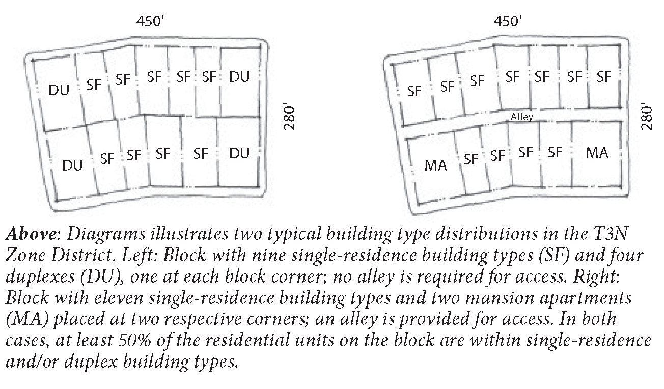
2.
Blocks within the T4N Transect Zone are intended to provide a mix of single-residence/unit, duplex and multi-residence/unit types.
a.
Blocks within the T4N Transect Zone shall provide a minimum of two building types per block.
b.
No block may be entirely composed of single-residence/unit and/or duplex building types.
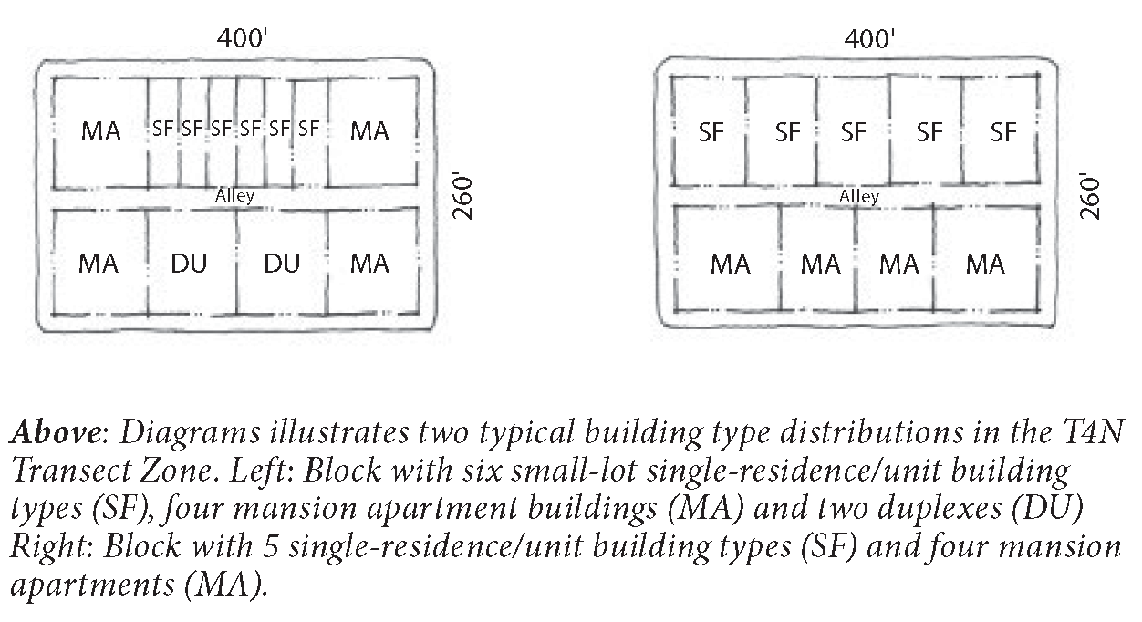
3.
Blocks within the T4NF or T5MSF Transect Zone are intended to provide the greatest diversity of building types.
a.
Blocks within the T4NF or T5MSF Transect Zone shall provide a minimum of three distinct building types per block.
b.
No more than 50% of the residential units on a block shall be located within single-residence/unit or duplex building types.
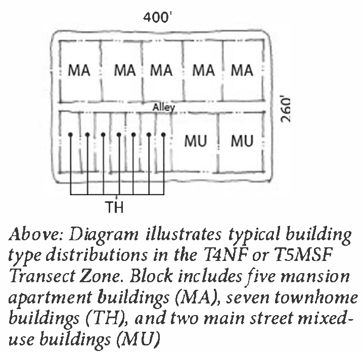
11-63-10: - MIX OF LOT SIZES
A mix of lot sizes introduces variety into the character of Smart Growth Community Plans.
A.
A mix of lot sizes shall be provided within pedestrian sheds and blocks as established in the table below.
B.
Lot shall vary by a minimum of 5 feet in width.
11-63-11: - INCENTIVES
To encourage the use of the SGCPs Chapter, the City Council shall grant the following incentives, to the extent authorized by State law:
A.
With an application for a Infill SGCP, separate review of a conceptual plat is no longer necessary, as it will be combined with the review for the Infill SGCP.
B.
An application for a preliminary plat and regulating plan with its associated Form-Based Code may be considered together. This has the advantage of reducing the amount of time required for project review and reduces otherwise applicable fees.
C.
A request for rezoning may occur concurrent with the request for a General Plan amendment to the Traditional Neighborhood or Mixed Use land use designation.
D.
Following approval of the SGCP, all applications for site plan and architectural review shall be reviewed and processed through the Director subject to the reduced fees established in the Appendix 2 (Planning Fee Schedule).
11-63-12: - SPECIAL REQUIREMENTS
A SGCP may designate any of the following special requirements:
A.
A differentiation of the thoroughfares as A-grid and B-grid. The review of Use Permits for buildings along the A-grid shall prioritize uses supportive of pedestrian activity. Buildings along the B-grid may be more readily considered for Use Permits allowing automobile-oriented standards. The frontages assigned to the B-grid shall not exceed 30% of the total length of frontages within a pedestrian shed.
B.
Designations for mandatory and/or recommended terminated vista locations, requiring or advising that the building be provided with architectural articulation of a type and character that responds visually to the location, as approved by the Director.
C.
A designation for cross block passages, requiring that a minimum 8-foot-wide pedestrian access be reserved between buildings.
D.
A designation for Buildings of Value, requiring that such buildings and structures may be altered or demolished only in accordance with Municipal Preservation Standards and Protocols.
E.
A designation for coordinated frontage, requiring that the standards in Table 11-61-9.E (Public Frontage Types), Table 11-61-9.F (Public Frontage Standards), and Chapter 11-60 (Private Frontage Standards) be coordinated as a single, coherent landscape and paving design.
F.
May designate one of the following mandatory retail frontage types:
1.
Shopfront. Designations for mandatory and/or recommended Shopfront Frontage, requiring or advising that a building provide a Shopfront Frontage at sidewalk level along the entire length of its private frontage. See Section 11-60-10 (Shopfront Frontage) for standards.
2.
Gallery. Designations for mandatory and/or recommended Gallery Frontage, requiring or advising that a building provide a permanent cover over the sidewalk, either cantilevered or supported by columns. See Section 11-60-12 (Gallery Frontage) for standards.
3.
Arcade. Designations for mandatory and/or recommended Arcade Frontage, requiring or advising that a building overlap the sidewalk such that the first floor façade is a colonnade. See Section 11-60-13 (Arcade Frontage) for standards.
G.
A designation of required Architectural Styles. The designation of required architectural styles requires the submittal of Architectural Guidelines or Pattern Book as part of a Final Development Plan.
11-63-13: - APPLICATIONS AND PROCESSING
A.
Submittal Requirements. Submittal requirements for each step in the approvals process can be found in the City of Mesa's SGCP submittal requirements handout.
B.
Pre-Submittal Meetings. Pre-submittal meetings allow potential applicants to review preliminary development proposals with the Director before substantial commitments of time and money have been made. During the pre-submittal phase the Director shall review submitted materials for compliance with the Form-Based Code and make recommendations to the applicant with regards to improvements that can increase compliance with the Code and ensure that future development processes are streamlined. The Director may forward review of relevant items to a Technical Advisory Committee as necessary to provide additional input and recommendations.
C.
Preliminary Development Plans. Preliminary development plans provide a public process for the evaluation and review of initial land development. These development plans enable detailed master planning for neighborhoods in a manner that assures that compliance with the intent and standards of the Code, while maintaining some degree of flexibility regarding the future build out of these areas. Such development plans will require the organization of streets, development blocks, and publicly accessible open spaces.
1.
The following information is required in order to demonstrate preliminary development plan compliance:
a.
A refined building form regulating plan that identifies pedestrian sheds and clarifies the location, size, and disposition of the transect areas;
b.
A refined streets and circulation regulating plan that clarifies the location of all primary streets and the type and location of all secondary streets, alleys, and other publicly accessible right-of-ways;
c.
A refined parks and open space regulating plan that identifies the types, sizes, and locations of all parks and open spaces;
d.
Existing conditions, indicating natural resources, topography, and site constraints.
e.
Utility locations and setbacks.
2.
Approval of preliminary development plan is granted by the Planning and Zoning Board. Appeals may be forwarded to the City Council.
3.
Modifications to preliminary development plans may be made through the final development plan process, provided that such modifications maintain substantial compliance with this Code and the refined regulating plans, and/or are within the bounds of a Minor Adjustment.
4.
Any modifications to existing zoning require approval by City Council.
D.
Final Development Plans. Final development plans provide a process for detailed administrative review and evaluation of development proposals to ensure compliance with the requirements of this Code. Final development plans may be prepared for all or portions of a preliminary subdivision plan area.
Final development plans shall demonstrate compliance with preliminary development plans. Minor deviations may be characterized as Minor Adjustments. Final development plans that do not demonstrate substantial compliance will require an amendment to an existing preliminary development plan, with additional approvals by the Planning and Zoning Board.
1.
The following information, in addition to the information required to demonstrate preliminary plan compliance, is required to demonstrate final development plan compliance:
a.
Neighborhood block development plans, including the following:
(1)
Lot lines and dimensions;
(2)
Individual lot layouts illustrating buildable areas as per transect zones, setbacks, and encroachment;
(3)
Identification of allowed building types;
(4)
Preliminary landscape and lighting plans for all civic spaces and public right-of-ways.
(5)
Preliminary grading plans showing modifications to existing conditions; and
(6)
Detailed utility locations, sizes and setbacks.
b.
Architectural Guidelines or Pattern Book, if required
2.
Preliminary and final development plans may be processed simultaneously.
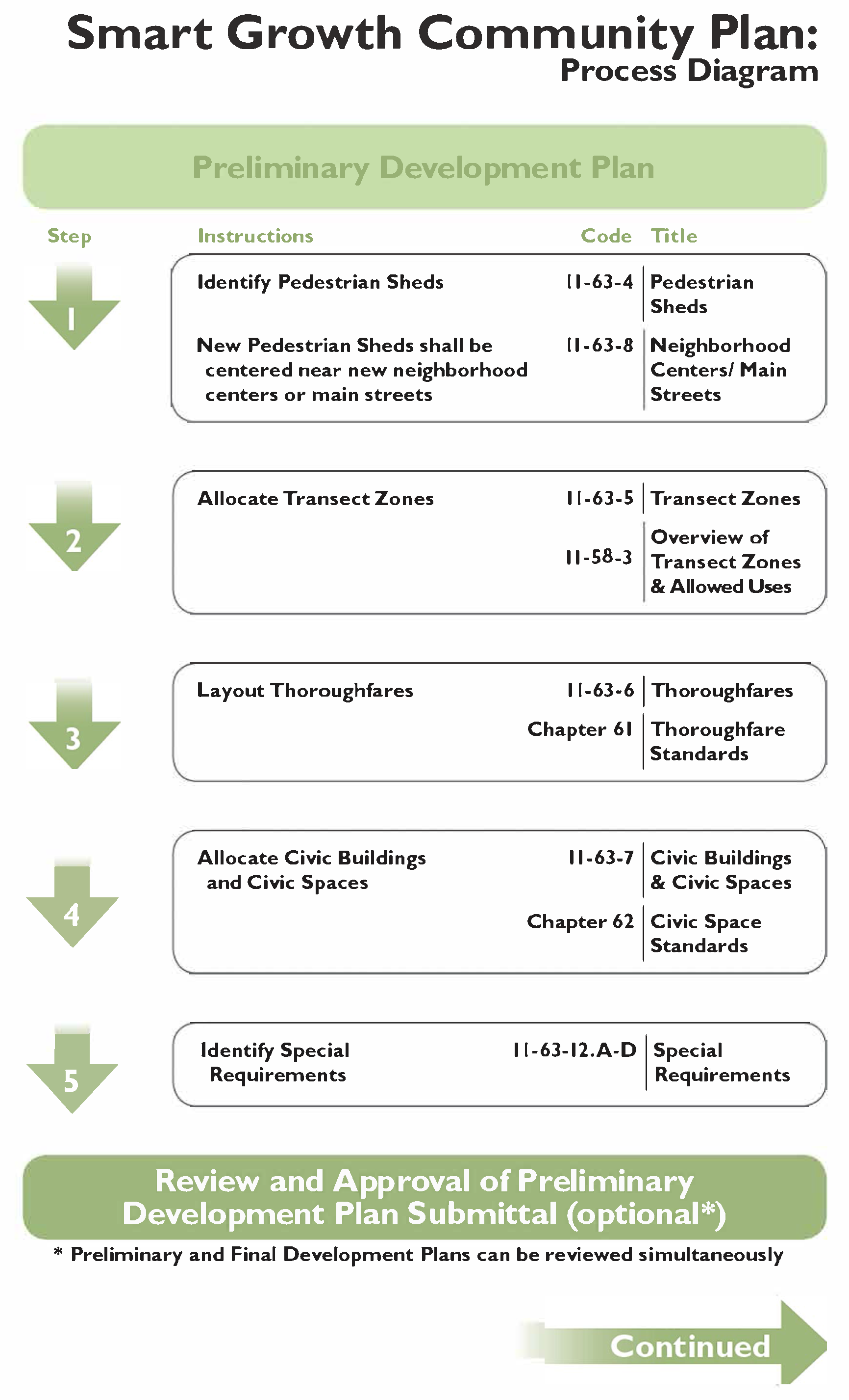
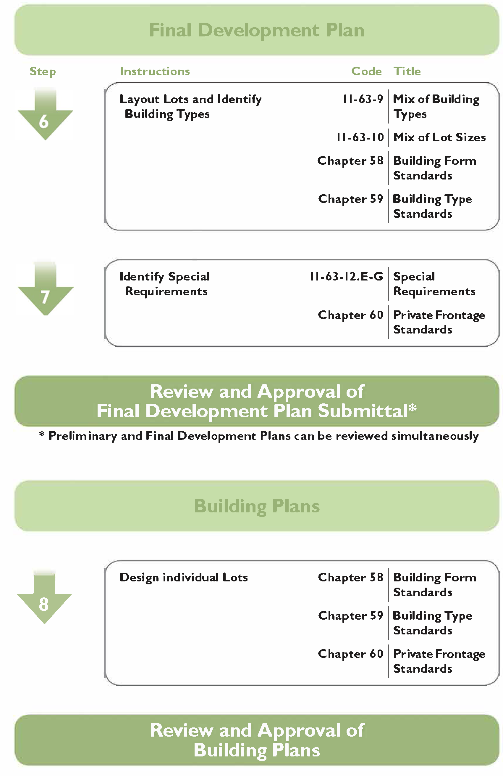
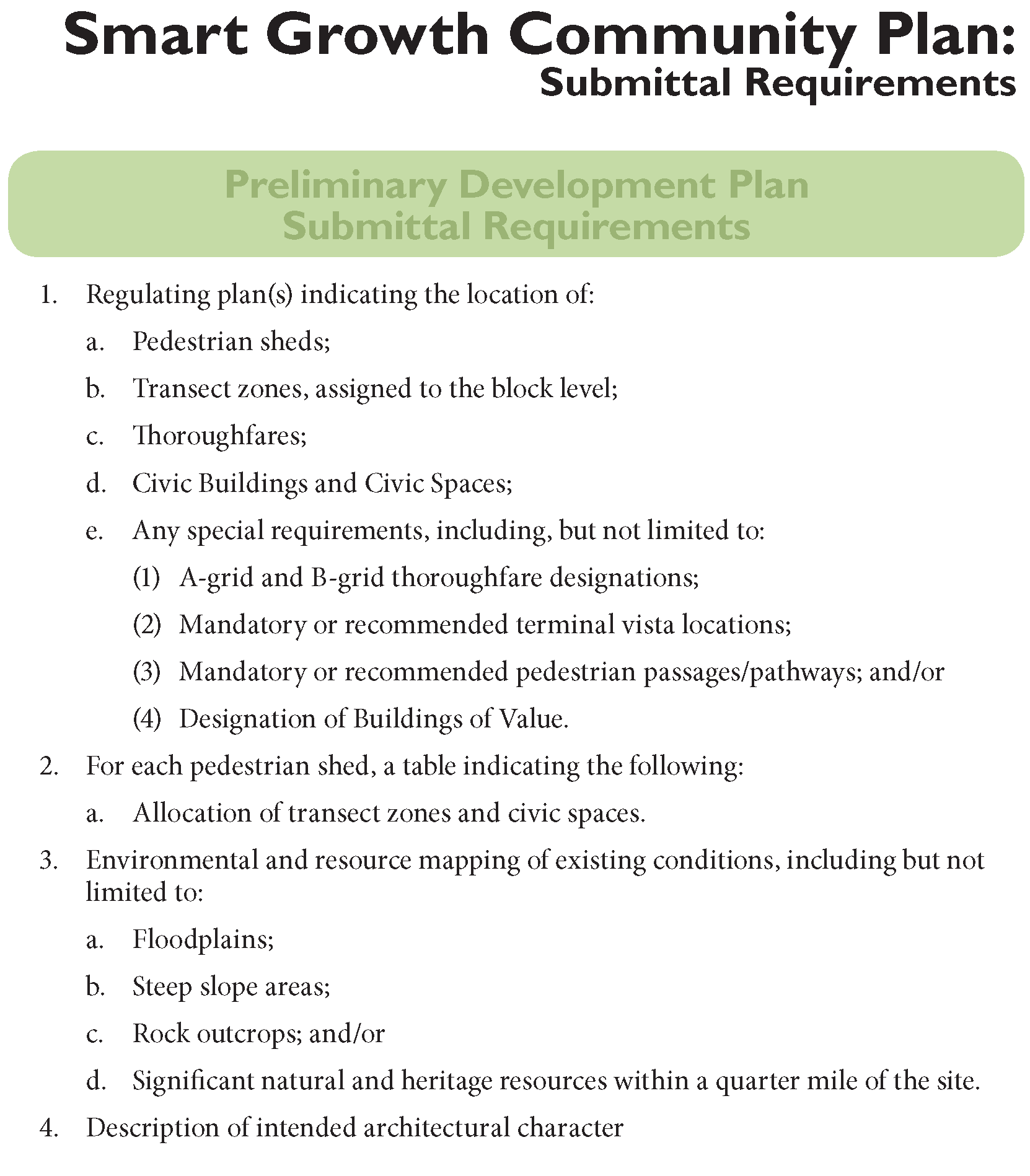
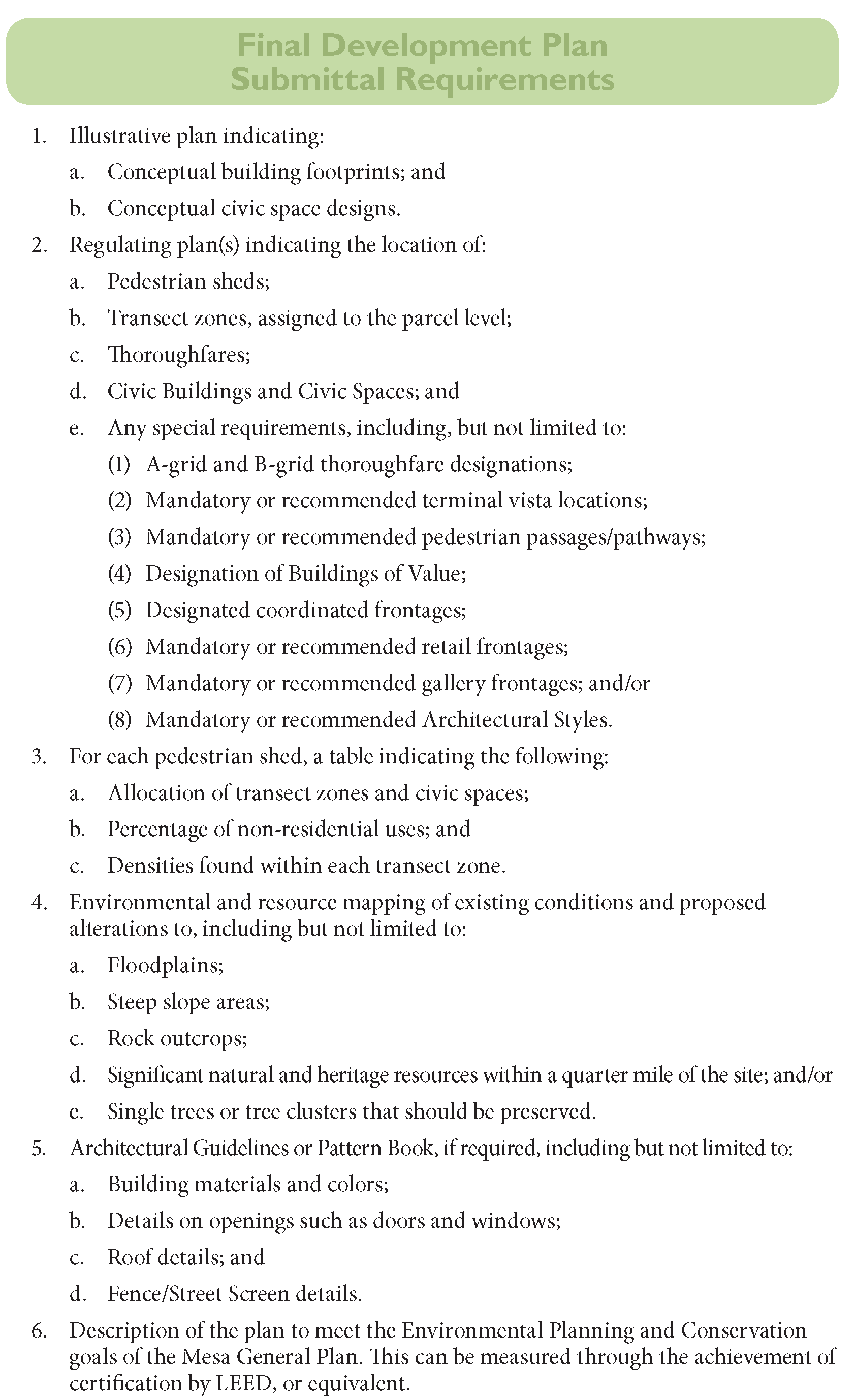
11-64-1: - PURPOSE
This Chapter provides the definitions of Land Uses and Specialized Terms and Phrases used in the Form-Based Code.
11-64-2: - APPLICABILITY
A.
The definitions in this Chapter shall apply to all proposed development within transect zones.
B.
In the event of conflict between the definitions found in this Chapter and the definitions found within the Zoning Code outside of Article 6 (Form-Based Development Regulations) these definitions shall prevail for all proposed development within transect zones.
11-64-3: - DEFINITIONS OF SPECIALIZED TERMS AND PHRASES
A.
Definitions.
Accessory Structure. A structure that is physically detached from, secondary and incidental to, and commonly associated with a primary structure and/or use on the same site. The use of the Accessory Structure must not change the character of the use for the site.
This definition includes, but is not limited to, the following detached accessory structures that are associated with a residential use property:
Garages (covered or enclosed) for the storage of automobiles (including incidental personal restoration and repair), personal recreational vehicles and other personal property; guest houses, studios, workshops, greenhouses (noncommercial), enclosed cabanas and pool houses, storage sheds, outdoor saunas, and other similar enclosed structures.
This definition also includes, but is not limited to, the following detached accessory structures normally associated with a nonresidential use property:
Garages (covered or enclosed) for the storage of automobiles and work related vehicles and equipment (including incidental restoration and repair), storage structures, workshops, studios, other similar enclosed or unenclosed structures.
A permitted Accessory Structure is not permitted by right to have an Accessory/Secondary Unit. This use is regulated separately as "Dwelling, Accessory/Secondary Unit."
Accessory Use. A use customarily incidental to, related and clearly subordinate to a principal use established on the same lot or parcel of land, which accessory use does not alter said principal use nor serve property other than the lot or parcel of land on which the principal use is located. "Appurtenant use" means the same as accessory use.
Adjoining. 2 or more lots or parcels of land sharing a common boundary line, or 2 or more objects in contact with each other. Lots or parcels of land which touch at corners only shall not be deemed adjoining. "Abut" or "abutting" and "contiguous" means the same as adjoining.
Administrative Use Permit (AUP). An AUP is a discretionary use permit issued by the Zoning Administrator for uses that are generally permitted within a district and usually are of low impact to the community and environment. Conditions of approval, mandatory review periods, and expiration periods may be required at the discretion of the Zoning Administrator. In granting conditional approval, the Zoning Administrator may impose requirements and conditions with respect to location, sitting, construction, maintenance, operation, duration, and overall development as deemed reasonable and necessary for the protection of adjacent properties and the public interest. If an Administrative Permit is denied by the Zoning Administrator, it may be appealed in accordance with Chapter 77 of the Zoning Ordinance.
Alcoholic Beverage Sales. The retail sale of beer, wine, and/or spirits for on-site or off-site consumption, either as part of another retail use, or as a primary business activity.
Ancillary Structure/Ancillary Building. See "Accessory Structure."
Apartment House. A Building Type. See Chapter 59 (Building Type Standards) for a description of and regulations for this building type.
Arcade. A Private Frontage Type. See Chapter 60 (Private Frontage Standards) for a description of and regulations for this private frontage.
Architectural Features. Exterior building elements intended to provide ornamentation to the building massing, including, but not limited to: eaves, cornices, bay windows, window and door surrounds, light fixtures, canopies, and balconies.
B.
Definitions.
Building Type. The structure defined by the combination of configuration, disposition, and function. See Chapter 59 (Building Type Standards) for a description of and regulations for allowed building types.
Build-to Line (BTL). A line parallel to a property line or right-of-way where a building façade must be placed. The BTL may appear graphically on the regulating plan or be stated as a maximum setback dimension from the property line or right-of-way. Examples 1 and 2 below depict how to calculate the percent of BTL Defined by a Building and percent of Building at the BTL as may be required in the Building Form Standards. Minor deviations from the BTL are allowed for Architectural Features, recessed entries, and recessed balconies. These minor deviations do not count against the calculations of percent of BTL Defined by a building or percent of Building at the BTL.
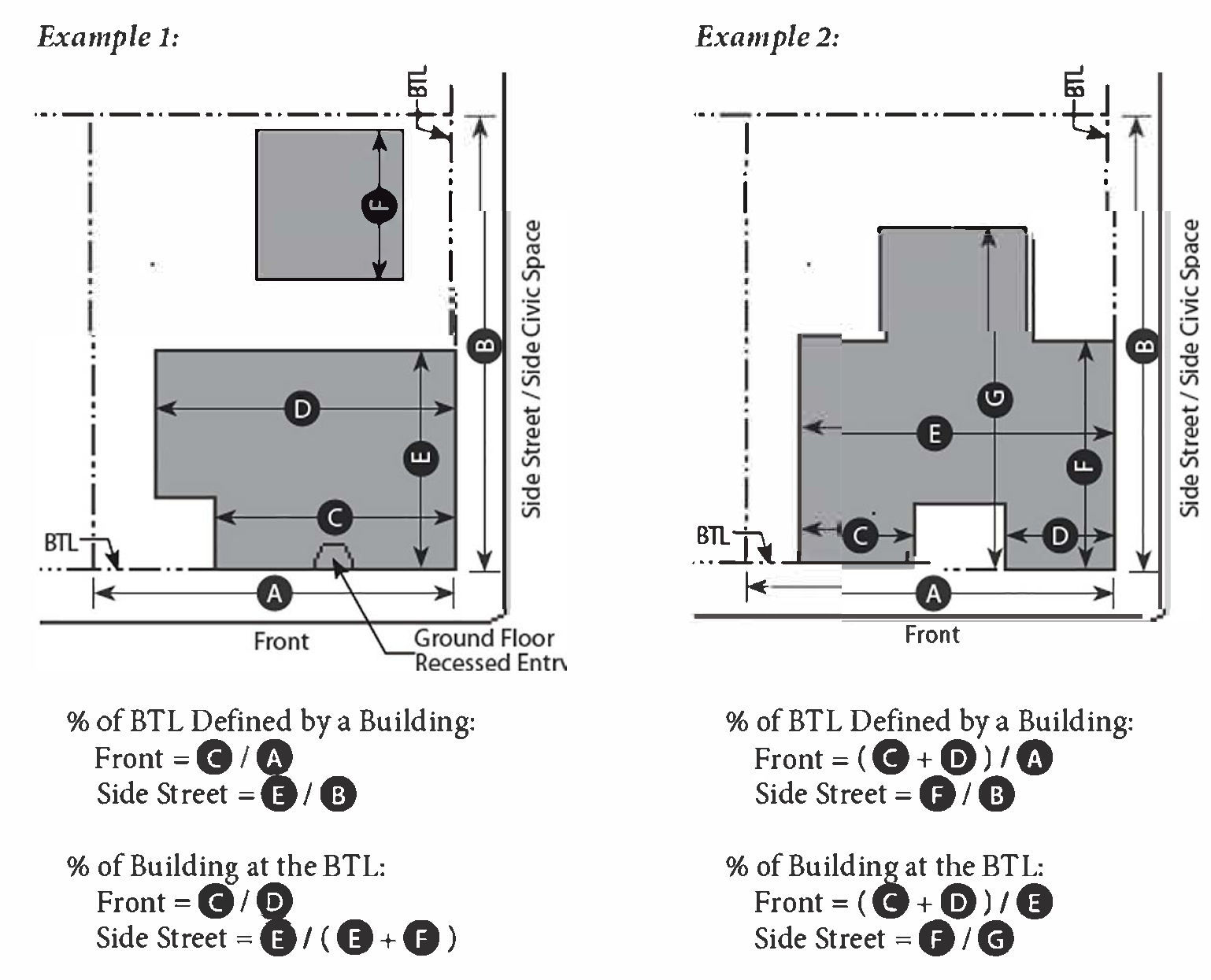
Bungalow Court. A Building Type. See Chapter 59 (Building Type Standards) for a description of and regulations for this building type.
C.
Definitions.
Carriage House. A Building Type. See Chapter 59 (Building Type Standards) for a description of and regulations for this building type.
Ceiling Height. See Measurements.
Civic. A term defining not-for-profit organizations, dedicated to arts, culture, education, religious activities, recreation, government, transit, and public parking facilities.
Civic Building. A structure operated by governmental or not-for-profit organizations and limited to civic and related uses.
Commercial. A term defining workplace, office and retail uses collectively.
Common Yard. See Chapter 60 (Private Frontage Standards) for a description of and regulations for this private frontage.
Common Courtyard. A Private Frontage Type. An entry court, forecourt or courtyard shared by multiple residential units or commercial spaces.
Community Garden. A Civic Space Type. See Chapter 62 (Civic Space Standards) for a description of and regulations for this Civic Space Type.
Community Park. A Civic Space Type. See Chapter 62 (Civic Space Standards) for a description of and regulations for this Civic Space Type.
Corner Element. A prominent architectural element, such as a tower, corner bay window (chamfered or round) or significant façade articulation, designed to accent the corner of a building and typically used to terminate a view or mark an important entrance.
Council Use Permit (CUP). A CUP is a discretionary permit issued by the City Council after review and recommendation by the Planning and Zoning Board. Council Use Permits will be reviewed in accordance with Section 11-70-6 of the Zoning Ordinance.
Courtyard Building. A Building Type. See Chapter 59 (Building Type Standards) for a description of and regulations for this building type.
D.
Definitions.
Depth, Ground-floor Commercial Space. See Measurements.
Development. Any man-made change to improved or unimproved real estate, including but not limited to the division of a parcel of land into 2 or more parcels; the construction, reconstruction, conversion, structural alteration, relocation, or enlargement of any structure; any mining, excavation, landfill or land disturbance; and any use or extension of the use of land.
Director. The Planning Director of the City of Mesa, or his or her duly appointed representative.
Dooryard. A Private Frontage Type. See Chapter 60 (Private Frontage Standards) for a description of and regulations for this private frontage.
Duplex. A Building Type. See Chapter 59 (Building Type Standards) for a description of and regulations for this building type.
Dwelling, Dwelling Unit, or Housing Unit. A room or suite of rooms, including permanent provisions for living, sleeping, eating, sanitation, and cooking, and designed or occupied as separate living quarters.
Accessory Dwelling Unit. An attached or detached self-contained living unit that is on the same lot or parcel as a single-family dwelling of greater square footage than the accessory dwelling unit, that includes its own sleeping and sanitation facilities and that may include its own kitchen.
Single-Unit Residence. A primary dwelling unit designed for occupancy by one household, and located on a separate lot from any other unit (except accessory living quarters, where permitted).
Multiple-Unit Residence. Two or more primary dwelling units on a single lot. Types of multiple residence dwellings include, but are not limited to duplexes, garden apartments, and multi-story apartment buildings.
E.
Definitions.
Encroachment. Any architectural feature, structure or structural element, such as a gallery, fence, dooryard, garden wall, porch, stoop, balcony, bay window, terrace or deck, that breaks the plane of a vertical or horizontal regulatory limit extending into a setback, beyond the build-to-line, into the public frontage, or above a height limit.
F.
Definitions.
Façade. The vertical surface of a building.
Façade Zone. The area between the minimum and maximum setback lines.
Street Façade. The vertical surface of a building located at the Build-to Line.
Flex Space. Space designed to accommodate an evolution of use over time in response to an evolving market demand. Typically designed to accommodate future commercial uses, while accommodating less intense short term uses such as residential or live/work, until the full commercial demand has been established.
Floor Finish Level. See Measurements.
Forecourt. A Private Frontage Type. See Chapter 60 (Private Frontage Standards) for a description of and regulations for this private frontage.
Formally Disposed. Composed in a regular, classical, and symmetrical manner.
Front. The primary frontage(s) of a lot, determined as follows:
For lots with frontages along multiple thoroughfares, the frontage along the thoroughfare with the most pedestrian activity, as determined by the Director, will always be treated as a Front. At key gateways, as identified by the Director, corner lots may be required to have multiple frontages along thoroughfares treated as Fronts. All other frontages along thoroughfares may be considered to be Side Street Frontages.
For lots with frontages along a thoroughfare and a civic space, the Front may be the frontage along either the thoroughfare or the civic space, or both frontages may be treated as Fronts, with the following exception: the frontage along certain Civic Spaces may be required to be a Front, as per the Civic Space Standards (see Chapter 62).
For lots with a single frontage along a thoroughfare or a Civic Space, but not both, that frontage is the Front.
Frontages along Alleys, Service Drives, and Parking Drives may never be a Front.
Frontage. The portion of a lot or parcel of land which borders on a thoroughfare or other public right-of-way or civic space.
Frontage, Private. The area between the property line or right-of-way and the building façade, which may be coterminous. See Chapter 60 (Private Frontage Types) for a description of and regulations for allowed Private Frontage Types.
Frontage, Public. The area between the curb of the vehicular lanes and the frontage line. See Table 11-61-9.E (Public Frontage Types) for a description of and regulations for allowed Public Frontage Types.
Frontage Line. The property lines of a lot along a thoroughfare or other public way, or a civic space.
G.
Definitions.
Gallery. A Private Frontage Type. See Chapter 60 (Private Frontage Standards) for a description of and regulations for this private frontage.
Greenway. A Civic Space Type. See Chapter 62 (Civic Space Standards) for a description of and regulations for this Civic Space Type.
H.
Definitions.
Hardscape. Part of a building's grounds consisting of elements such as plazas, retaining walls and sidewalks, made with materials such as but not limited to, concrete and sidewalk pavers.
Height. See Measurements.
High-Rise. A Building Type. See Chapter 59 (Building Type Standards) for a description of and regulations for this building type.
I.
Definitions.
Infill/Redevelopment. The development of vacant land that was bypassed by earlier waves of development and is now largely surrounded by developed land or land that previously developed, then cleared.
J.
Definitions.
No specialized terms beginning with the letter J are defined at this time.
K.
Definitions.
No specialized terms beginning with the letter K are defined at this time.
L.
Definitions.
Landscaping. The planting, configuration and maintenance of trees, ground cover, shrubbery and other plant material, decorative natural and structural features (walls, fences, hedges, trellises, fountains, sculptures), earth patterning and bedding materials, and other similar site improvements that serve an aesthetic or functional purpose.
Landscaped Area. The area within a parcel containing landscaping, excluding building footprints, paved driveways, parking areas, decks, patios, walkways and undisturbed natural areas. Water features are included in the landscaped area.
Liner Building. An occupiable structure specifically designed to mask a parking lot or a parking structure from a frontage.
Live/Work Unit. An integrated housing unit and working space occupied and utilized by a single household in a structure that has been designed or structurally modified to accommodate joint residential occupancy and work activity, and which includes complete kitchen space and sanitary facilities in compliance with the Building Code; and Working space reserved for and regularly used by one or more occupants of the unit.
M.
Definitions.
Main Street Mixed-Use. A Building Type. See Chapter 59 (Building Type Standards) for a description of and regulations for this building type.
Mansion Apartment. A Building Type. See Chapter 59 (Building Type Standards) for a description of and regulations for this building type.
Measurements.
Depth, Ground-floor Commercial Space. The depth of the ground floor space available to a commercial tenant. Service cores (stairs and elevators), double height lobbies, trash rooms, and other building elements may encroach upon the required depth up to 50% of the required depth for a maximum of 25% of the width of the tenant space.
Ceiling Height. Height from finished floor to finished ceiling of primary rooms, not including secondary rooms such as bathrooms, closets, utility rooms, and storage spaces.
Floor Finish Level. Height difference between public walk adjacent to the front and the floor. Regulations for ground floor finish level for ground floor residential uses do not apply to ground floor lobbies and common areas in multi-unit buildings.
Ground Floor Transparency. The percentage of the area, measured from floor to ceiling, of the ground floor wall along the frontage that is constructed with transparent materials. Includes the transparent glazing of storefronts, windows, transoms, and doors.
Height. A limit to the vertical extent of a building that is measured in number of stories. Where maximum height is measured in feet, the measurement is taken to the eave of a sloped roof or the base of a parapet wall. Height limits do not apply to masts, belfries, clock towers, chimney flues, water tanks, elevator bulkheads, and similar structures that do not occupy greater than ten percent (10%) of the roof, which may be of any height approved by the Planning Director.
Upper Floor Ceiling Height. Height from finished floor to finished ceiling of primary rooms on the upper floors not including secondary rooms such as bathrooms, closets, utility rooms, and storage spaces.
Mid-Rise. A Building Type. See Chapter 59 (Building Type Standards) for a description of and regulations for this building type.
Mixed-use. Multiple functions vertically superimposed within the same building or horizontally superimposed across the same development site or same general area through adjacency.
Mixed-Use Project. A development that combines both commercial and residential uses on the same site.
N.
Definitions.
Naturally Disposed. A preservation of the existing natural condition or a composition of elements arranged as they would appear in nature, with irregular shapes, patterns, rhythms, and asymmetry.
Neighborhood Green. A Civic Space Type. See Chapter 62 (Civic Space Standards) for a description of and regulations for this Civic Space Type.
Neighborhood Square. A Civic Space Type. See Chapter 62 (Civic Space Standards) for a description of and regulations for this Civic Space Type.
O.
Definitions.
Open Space. The area or areas of a lot or parcel intended to provide light and air, and designed for either scenic and/or recreational purposes, excluding buildings, parking, driveways and other vehicular surfaces.
Common Open Space. An open space intended for the shared, common use of the occupants of a development.
Private Open Space. An open space intended for the exclusive use of the occupants of a dwelling unit.
P.
Definitions.
Parking Access Drive. An accessway within a public right-of-way that provides vehicular access between a street or alley and the on-site parking.
Paseo. A pedestrian alley located and designed to reduce the required walking distance within a neighborhood.
Pedestrian Shed. An area centered on a major destination. Its size is limited by an average distance that may be traversed at an easy walking pace in a given amount of time from its center to its edge. Specific Pedestrian sheds are established through a regulating plan. See Section 11-63-4 (Pedestrian Sheds).
Permitted Use. Any use allowed in a Transect Zone without a requirement for approval of a discretionary use permit, but subject to any restrictions applicable to that transect.
Playground. A Civic Space Type. See Chapter 62 (Civic Space Standards) for a description of and regulations for this Civic Space Type.
Plaza. A Civic Space Type. See Chapter 62 (Civic Space Standards) for a description of and regulations for this Civic Space Type.
Pocket Plaza. A Civic Space Type. See Chapter 62 (Civic Space Standards) for a description of and regulations for this Civic Space Type.
Pocket Park. A Civic Space Type. See Chapter 62 (Civic Space Standards) for a description of and regulations for this Civic Space Type.
Porch, Projecting or Engaged. A Private Frontage Type. See Chapter 60 (Private Frontage Standards) for a description of and regulations for this private frontage.
Prohibited Uses. Uses not listed in Table 11-58-3.A "Composite Use Table" are specifically prohibited unless an interpretation of the Zoning Administrator determines that a use is consistent pursuant to the Code.
Q.
Definitions.
No specialized terms beginning with the letter Q are defined at this time.
R.
Definitions.
Regional Park. A Civic Space Type. See Chapter 62 (Civic Space Standards) for a description of and regulations for this Civic Space Type.
Residential. Enclosed space with a minimum 400 gross square feet used primarily for human habitation.
S.
Definitions.
Setback. The area between a property line and a building or structure which must be kept clear or open.
Shared Parking. Any parking spaces assigned to more than one use, where persons utilizing the spaces are unlikely to need the spaces at the same time of day.
Shopfront. A Private Frontage Type. See Chapter 60 (Private Frontage Standards) for a description of and regulations for this private frontage.
Single-Unit House, Cottage or Village. A Building Type. See Chapter 59 (Building Type Standards) for a description of and regulations for this building type.
Special Use Permit (SUP). A SUP is a discretionary permit issued by the Zoning Administrator or Board of Adjustment. Special Use Permits will be reviewed in accordance with Section 11-70-5 of the Zoning Ordinance.
Sport Complex. A Civic Space Type. See Chapter 62 (Civic Space Standards) for a description of and regulations for this Civic Space Type.
Stoop. A Private Frontage Type. See Chapter 60 (Private Frontage Standards) for a description of and regulations for this private frontage.
Storefront. The portion of a frontage that is composed of the display window and/or entrance and its components including windows, doors, transoms and sill pane that is inserted into various frontage types, such as a shopfront or gallery, to accommodate retail.
Story. A habitable floor level within a building, typically 8' to 14' high from floor to ceiling. The number of stories is measured from the sidewalk of the primary street.
Story, Half. A conditioned space that rests primarily underneath the slope of the roof, usually having dormer windows and occupying about half the area of the floor or floors below.
Structure. Anything constructed or erected, which requires a fixed location on the ground, or is attached to something having a fixed location on the ground. For the purposes of this Code, the term "structure" includes "buildings," and tents, but does not include swimming pools.
Structured Garage. (syn. Structured Parking). A Parking facility in or under a multi-story building.
Substantial Conformance. Substantial conformance shall mean physical improvements to the existing development site which constitute the greatest degree of compliance with this Ordinance that can be attained without causing or creating any of the following conditions:
1.
The demolition or reconstruction of existing buildings or other significant structures (except signs); or
2.
The cessation of the existing conforming use, or the preclusion of any other lawful, permitted use.
3.
The creation of new non-conforming conditions.
T.
Definitions.
Terrace. A Private Frontage Type. See Chapter 60 (Private Frontage Standards) for a description of and regulations for this private frontage.
Temporary Parking Lots. Parking lots that are not permanent and are only intended to fulfill a short-term need and will ultimately be replaced by a permanent building or structure.
Townhouse. A Building Type. See Chapter 59 (Building Type Standards) for a description of and regulations for this building type.
Transect. A geographical cross-section of a region used to reveal a sequence of environments. For human environments, this cross section can be used to identify a set of habitats that vary by their level and intensity of urban character, a continuum that ranges from rural to urban. Transects form the basis for organizing the components of the built world, including building, lot, land use, street, and all of the other physical elements of the human habitat.
Transect Zone. Transect Zones are administratively similar to the land use zones in conventional codes, except that in addition to the usual building use, density, height, and setback requirements, other elements of the intended habitat are integrated, including those of the private lot and building and the enfronting public streetscape. The elements are determined by their location on the Transect scale.
Transit Station. A lot, or structure used for the purpose of parking, loading, unloading of passengers from light-rail, train, or bus transportation. May include parking facilities and other commercial amenities to service transit.
Transit Stop. Locations designated by the transit authority in which patrons may access or exit from regularly scheduled BRT or bus service.
Transparency, Ground-floor. See Measurements.
U.
Definitions.
No specialized terms beginning with the letter U are defined at this time.
V.
Definitions.
No specialized terms beginning with the letter V are defined at this time.
W.
Definitions.
No specialized terms beginning with the letter W are defined at this time.
X.
Definitions.
No specialized terms beginning with the letter X are defined at this time.
Y.
Definitions.
No specialized terms beginning with the letter Y are defined at this time.
Z.
Definitions.
No specialized terms beginning with the letter Z are defined at this time.
(Ord. No. 5948, §§ 3, 4, 7-1-25)
11-64-4: - DEFINITIONS OF LAND USES
A.
Definitions.
Alcohol Beverage Sales. The retail sale of beer, wine, and/or spirits in sealed containers for on-site or off-site consumption, either as part of another retail use, or as a primary business activity.
Animal Day Care. Facilities in which owners of small animals, principally dogs and cats, may contract with the operator for the keeping of pets for short, temporary periods, usually 1 day or less, but occasionally up to a week or so while the pet owner(s) are unable to care for the animals.
ATM. An automated teller machine (computerized, self-service machine used by banking customers for financial transactions, including deposits, withdrawals and fund transfers, without face-to-face contact with financial institution personnel), located outdoors at a bank, or in another location. Does not include drive-up ATM's.
B.
Definitions.
Bank, Financial Services. Financial institutions providing retail banking services. This classification includes only those institutions engaged in the on-site circulation of money, including credit unions, but excluding non-chartered financial institutions and check-cashing stores as a primary use. (See also, "ATM")
Boarding House. A residential dwelling for five (5) or more unrelated individuals in which the owner(s) provides lodging for compensation. A boarding house is occupied by individuals where rent is charged separately for the individual rooms or partitioned areas and may or may not be equipped with kitchen facilities and congregate dining facilities. The term includes similar congregate living arrangements but does not include community residences, hotels, motels, residential inns or bed and breakfasts.
Business Support Service. Establishments that primarily provide goods and services to other businesses on a fee or contract basis, including printing and copying, blueprint services, advertising and mailing, equipment rental and leasing, office security, custodial services, photo finishing, and model building.
C.
Definitions.
Civic Space. See Chapter 11-62 (Civic Space Types).
Commercial Recreation Facility. Provision of participant or spectator recreation to the general public, excluding public park and recreation facilities.
Small Indoor. This classification includes small, indoor facilities less than or equal to 3,000, such as billiard parlors, bowling centers, card rooms, dance halls, poolrooms, amusement arcades, and similar activities as interpreted by the Zoning Administrator. This classification may include restaurants, snack bars, and other incidental food and beverage services to patrons.
Medium Indoor. This classification includes small, indoor facilities greater than 3,000 sf but less than 10,000 sf, such as billiard parlors, bowling centers, card rooms, dance halls, amusement arcades, and similar activities as interpreted by the Zoning Administrator. This classification may include restaurants, snack bars, and other incidental food and beverage services to patrons.
Large, Indoor. This classification includes large indoor facilities of 10,000 square feet or larger in building area, including ice or roller skating rinks; swimming or wave pools; miniature golf courses; archery or indoor shooting ranges, and similar activities as interpreted by the Zoning Administrator. This classification may include restaurants, snack bars, and other incidental food and beverage services to patrons.
Outdoor. This classification includes large generally outdoor facilities such as amusement and theme parks, sports stadiums and arenas, racetracks, amphitheaters, driving ranges, golf courses (daily fee), riding stables, campgrounds, and similar activities as interpreted by the Zoning Administrator. This classification may include restaurants, snack bars, and other incidental food and beverage services to patrons.
Community Residence. A community residence is a residential living arrangement for five to ten individuals with disabilities, excluding staff, living as a family in a single dwelling unit who are in need of the mutual support furnished by other residents of the community residence as well as the support services, if any, provided by the staff of the community residence. Residents may be self-governing or supervised by a sponsoring entity or its staff, which provides habilitative or rehabilitative services related to the residents' disabilities. A community residence seeks to emulate a biological family to foster normalization of its residents and integrate them into the surrounding community. Its primary purpose is to provide shelter in a family-like environment. Medical treatment is incidental as in any home. Supportive interrelationships between residents are an essential component. Community residence includes sober living homes and assisted living homes but does not include any other group living arrangement for unrelated individuals who are not disabled nor any shelter, rooming house, boarding house or transient occupancy.
Family Community Residence. A community residence is a relatively permanent living arrangement with no limit on the length of tenancy as determined in practice or by the rules, charter, or other governing documents of the community residence. The minimum length of tenancy is typically a year or longer.
Transitional Community Residence. A community residence that provides a relatively temporary living arrangement with a limit on length of tenancy less than a year that is measured in weeks or months, as determined either in practice or by the rules, charter, or other governing document of the community residence.
D.
Definitions.
Day Care Centers. Establishments providing non-medical care for persons on a less than 24-hour basis other than Day Care Homes. This classification includes nursery schools, preschools, and day care facilities for children or adults, and any other day care facility licensed by the State of Arizona.
Day Care Home. A facility, the primary use of which is a residence, in which care of individuals is regularly provided for compensation for periods of less than 24 hours per day.
Small Day Care Home. Home day care for 5 or less people full-time or part-time.
Large Day Care Home. Home day care for more than 5 people full-time and part-time but no more than 10 people full-time and part-time.
Dwelling, Dwelling Unit, or Housing Unit. A room or suite of rooms, including permanent provisions for living, sleeping, eating, sanitation, and cooking, and designed or occupied as separate living quarters.
Accessory Dwelling Unit. An attached or detached self-contained living unit that is on the same lot or parcel as a single-family dwelling of greater square footage than the accessory dwelling unit, that includes its own sleeping and sanitation facilities and that may include its own kitchen.
Single-Unit Residence. A primary dwelling unit designed for occupancy by one household, and located on a separate lot from any other unit (except accessory living quarters, where permitted).
Multiple-Unit Residence. Two or more primary dwelling units on a single lot. Types of multiple residence dwellings include duplexes, garden apartments, and multi-story apartment buildings.
E.
Definitions.
Eating and Drinking Establishments. Businesses primarily engaged in serving prepared food and/or beverages for consumption on or off the premises. Includes, but is not limited to the following sub-categories:
Bars/Clubs/Lounges. Businesses serving beverages for consumption on the premises as a primary use including on-sale service of alcohol including beer, wine, or mixed drinks, and businesses for which food sales are less than 30 percent of gross revenue.
Restaurants, Bar and Grill. Restaurants providing food and beverage services to patrons who order and are served while seated and pay after eating. Takeout service may be provided, food sales are at least 30 percent but less than 40 percent of gross sales revenue.
With Outdoor Seating Areas. Provision of outdoor dining facilities on the same property or in the adjacent public right-of-way.
F.
Definitions.
Family. An individual or two (2) or more individuals related by blood, marriage or adoption, or a group of no more than four (4) unrelated individuals, living together as a single housekeeping unit. A family includes a couple in a domestic relationship and biological, adopted, and foster children of either partner. The term family includes unrelated persons with developmental disabilities (as defined in A.R.S. § 36-581) living together in compliance with A.R.S. § 36-582.
Farmer's Market. Periodic outdoor sales activities involving the display and sale of fresh produce and locally produced food and beverage items, including baked goods, jams, jellies, and similar food products. The display and sale of hand-crafted artisan items may be considered as an accessory activity, provided the principal activity remains the sale of the food- or produce-related items.
G.
Definitions.
General Retail. Stores and shops intended to serve the City as convenience shopping or destination retail. The retail sale or rental of merchandise not specifically listed under another use classification. This classification includes grocery stores, neighborhood markets, department stores, clothing stores, furniture stores, pet supply stores, small hardware stores, and businesses retailing the following goods: toys, hobby materials, handcrafted items, jewelry, cameras, photographic supplies and services (including portraiture and retail photo processing), medical supplies and equipment, pharmacies, electronic equipment, records, sporting goods, kitchen utensils, hardware, appliances, antiques, art galleries, art supplies and services, paint and wallpaper, carpeting and floor covering, office supplies, bicycles, video rental, and new automotive parts and accessories (excluding vehicle service and installation). Retail sales may be combined with other services such as office machine, computer, electronics, and similar small-item repairs. This classification includes secondhand and wholesale stores, but does not include pawn shops.
On-Site Production. The assembly, fabrication, and conversion of materials into products for sale as an accessory use to a permitted General Retail activity. Such uses include, but are not limited to: artisan/craft products such as jewelry, pottery and other ceramics, small glass and metal art; tailoring of clothing; small, handmade custom furniture; musical instruments; toys; and other similar uses as interpreted by the Zoning Administrator.
H.
Definitions.
Health/Fitness Facility. A fitness center, gymnasium, health and athletic club, which may include any of the following:
Exercise machines, weight facilities, group exercise rooms, sauna, spa or hot tub facilities, indoor tennis, handball, racquetball, and other indoor sports activities, indoor or outdoor pools.
Home Occupation. Residential premises used for the transaction of business or the supply of professional services. Home occupation shall be limited to the following: agent, architect, artist, broker, consultant, draftsman, dressmaker, engineer, interior designer, lawyer, notary public, teacher, and other similar occupations, as determined by the Zoning Administrator. The total gross area of the home occupation use shall not exceed 25 percent of the gross square footage of the residential unit. The home occupation use shall not disrupt the generally residential character of the neighborhood.
I.
Definitions.
No land uses beginning with the letter I are defined at this time.
J.
Definitions.
No land uses beginning with the letter J are defined at this time.
K.
Definitions
Kennel. Facilities for keeping, boarding, training, breeding or maintaining for commercial purposes, four (4) or more dogs, cats, or other household pets not owned by the kennel owner or operator. This classification excludes pet shops and animal hospitals that provide 24-hour accommodation of animals receiving medical or grooming services.
L.
Definitions.
Library, Museum. Public or quasi-public facilities, examples of which include: aquariums, arboretums, art galleries and exhibitions, historic buildings and exhibits, libraries, museums, and planetariums. May also include accessory retail uses such as a gift/book shop, restaurant, etc.
Lodging:
Bed & Breakfast Inn (B&B). Establishments providing not more than 5 guest rooms for lodging on a less than weekly basis typically in a converted single-residence or multi-residence dwelling, with incidental eating and drinking service provided from a single kitchen for lodgers and residents only.
Hostel. A facility for residence of under twenty-nine (29) days that provides simple dormitory or sleeping rooms and common rooms for cooking, meeting, recreational, and educational use; that is chartered or approved by the International Hostel Federation or its national or regional affiliates, or similar organizations; and that is supervised by resident house-parents or managers.
Hotel/Motel. Establishments with guest rooms or suites, with or without kitchen facilities, rented to the general public for transient lodging. These establishments may provide additional accessory services, such as conference and meeting rooms, restaurants, or bars available to guest and general public. Also includes accessory guest facilities such as swimming pools, tennis courts, indoor athletic facilities, accessory retail uses, etc. This classification includes motels, extended-stay hotels, and tourist courts, but does not include rooming houses, boarding houses, or private residential clubs. The lengths of stays for the majority of guests at these facilities are for 30 days or less.
Inn/Lodge. A building used for temporary accommodation that includes the business of renting out no fewer than have (5) and no greater than twenty (20) guest rooms, where payment for occupancy is on a daily or weekly basis. The Inn/Lodge may include common lobby, indoor recreation, living and dining areas.
M.
Definitions.
Medical Services:
Hospitals. Institutions providing medical and surgical care to the sick or injured, including operating facilities and beds for patients to stay overnight. These establishments may include nursing facilities, extended care facilities, physical therapy, gift shops, retail pharmacies, employee housing, temporary housing for patient families, cafeterias or restaurants, and related uses operated primarily for the benefit of patients, staff, and visitors.
Medical/Dental Clinic. Facilities with five or more licensed practitioners and/or medical specialist, other than hospitals, where patients are admitted for examinations and treatment on either a "walk-in" or "appointment" basis. Patients are treated on an outpatient basis and are not admitted for overnight treatment or observation. This classification includes emergency medical services offered exclusively on an out-patient basis, such as urgent care centers.
Medical/Dental Office. Offices where medical and dental services are provided by no more than four licensed primary practitioners (e.g. physicians, dentists, chiropractors, optometrists, and similar medical professionals). This classification also includes physical therapy, massage therapy, and counseling services related to medical conditions.
Meeting Facility, Public or Private. A facility for public or private meetings, including: Community centers, civic and private auditoriums, reception centers halls, union halls, meeting halls for clubs and other membership organizations, etc. Also includes functionally related internal facilities such as kitchens, multi-purpose rooms, and storage. Does not include conference and meeting rooms, accessory and incidental to another primary use, and which are typically used only by on-site employees and clients, and occupy less floor area on the site than the offices they support. Cinemas, performing arts theaters, indoor commercial sports assembly or other commercial entertainment and related on-site facilities such as day care centers and schools are separately defined and regulated.
N.
Definitions.
Non-charted Financial Institution. A business, other than a state or federally chartered bank, credit union, mortgage lender or savings and loan association, that offers check cashing services and loans for payment of a percentage fee. Specifically included are check cashing businesses that charge a percentage fee for cashing a check or negotiable instrument, and payday loan businesses that make loans upon assignment of wages received. Excluded are retail uses in which a minimum of 70 percent of the floor area of the store is devoted to the display or sale of merchandise.
O.
Definitions.
Office, Professional, administrative. Offices of firms or organizations providing professional, executive, management, administrative or design services, such as accounting, architectural, computer software design, engineering, graphic design, interior design, investment, and legal offices.
P.
Definitions.
Parking Facility, Public or Commercial. Parking lots or structures operated by the City, or a private entity, providing parking either for free or for a fee. Does not include towing impound and storage facilities.
Pawn Shops. A business in which a principal business activity involves advancing money on the security of pledged goods or purchasing tangible personal property on the condition that it may be redeemed or repurchased by the seller for a fixed or variable price within a fixed or variable period of time.
Personal Services. Provision of recurrently needed services of a personal nature. This classification includes barber and beauty shops, seamstresses, tailors, dry cleaning agents (excluding large-scale bulk cleaning plants), shoe repair shops, self-service laundries, photocopying and photo finishing services, and travel agencies.
Place of Worship. A facility for religious worship and incidental religious education and offices, and may include private schools (Grades: Kindergarten through 12) for primary or secondary education, as defined in this section. This classification includes churches, temples, and other facilities used primarily for religious services or activities.
Public Safety Facility. Facilities providing public-safety and emergency services, including police and fire protection and emergency medical services, with incidental storage, and maintenance facilities.
Q.
Definitions.
No land uses beginning with the letter Q are defined at this time.
R.
Definitions.
Recycling - small collection facility. A center, occupying an area of 350 square feet or less, where the public may donate, redeem or sell recyclable materials. Includes reverse vending machines.
S.
Definitions.
Schools, Public or Private.
K-12. Facilities for primary or secondary education, including public schools, charter schools, and private institutions having curricula of general academic education consistent with the academic requirements of the State of Arizona, including kindergarten, elementary, junior high school, and high school, including accessory facilities traditionally associated with schools, such as athletic stadia, cafeterias and libraries.
Colleges or Universities, Public or Private. A post-secondary institution of higher learning that grants associate and/or bachelor's degrees, and may also have research facilities and/or professional schools that grant master and/or doctoral degrees. This classification includes community colleges that grant associate degrees, and/or certificates of completion in business or technical fields.
Commercial Trade Schools, Public or Private. Schools established to provide teaching of clerical, managerial, or artistic skills, such as accounting, data processing, or computer repair. This classification excludes schools offering training in industrial trades, such as welding or metal fabrication and establishments providing training for activities that are not otherwise allowed in the zoning district.
Does not include pre-schools and child day care facilities (see "Day Care"). See also the definition of "Studio: Art, Dance, Martial Arts, Music, etc." for smaller-scale facilities offering specialized instruction
Skilled Nursing Facility. A health care institution other than a hospital, assisted living facility or nursing and convalescent home which provides resident beds or dwelling units, supervisory care services, personal care service, directed care services or health-related services for persons on a temporary basis. Skilled nursing facilities do not emulate a family and normalization and community integration are not among their core goals. This classification does not include community residences, assisted living homes, assisted living centers, or social service facilities.
Social Service Facility. A facility where the primary purpose is to provide either: 1) On-site food, clothing, shelter, employment or other related services, such as counseling for employment, or other services for individuals with limited ability for self care; or 2) Alcohol, drug, or substance abuse or other treatment or medical programs or services, such as detoxification, where shelter is incidental and of limited duration. The term includes homeless shelters, charity dining facilities, rescue missions, day labor hiring centers, substance abuse and detoxification center, and similar facilities, but does not include care facilities such as community residences, group foster homes, correctional transitional housing facilities, nursing and convalescent homes, or assisted living facilities.
Stealth Wireless Telecommunications Facility. Any commercial wireless communications facility that is designed to blend into the surrounding environment by means of screening, concealment, or camouflage. The antenna and supporting antenna equipment are either not readily visible beyond the property on which they are located, or, if visible, appear to be part of the existing landscape or environment rather than identifiable as a wireless communications facility.
Studio - Art, Dance, Martial Arts, Music, etc. Small-scale facilities, that provide instructional space for groups of students. Examples of these facilities include: Individual and group instruction and training in the arts; production rehearsal; photography, and the processing of photographs produced only by users of the studio facilities; martial arts training studios; gymnastics instruction, and aerobics and gymnastics studios with no other fitness facilities or equipment. Also includes production studios for individual musicians, painters, sculptors, photographers, and other artists.
T.
Definitions.
Tattoo and Body Piercing Parlors. Establishments whose principal business activity is one (1) or more of the following: 1) using ink or other substances that result in the permanent coloration of the skin through the use of needles or other instruments designed to contact or puncture the skin; or 2) creation of an opening in the body of a person for the purpose of inserting jewelry or other decoration. Exception: Piercing earlobes as an accessory or subordinate activity when done at a shop or store selling jewelry as primary activity.
Theater, Cinema or Performing Arts. An indoor facility for group entertainment, other than sporting events. Examples of these facilities include: Civic theaters, facilities for "live" theater and concerts, and movie theaters.
Temporary Event Parking. Parking areas intended for overflow parking for stadiums, performing arts centers, competitive aquatic facilities, and similar public event facilities and located within 600 feet of the public facility being served.
U.
Definitions.
No land uses beginning with the letter U are defined at this time.
V.
Definitions.
Veterinary Services. Medical care for small and large animals on a commercial basis. This classification allows 24-hour accommodation of animals receiving medical or grooming services but does not include kennels. This classification includes animal hospitals and clinics providing services such as medical examinations, diagnosis, and procedures; dispensing of medications for animals; providing surgical procedures, and space for supervised recuperation from medical and surgical procedures.
W.
Definitions.
No land uses beginning with the letter W are defined at this time.
X.
Definitions.
No land uses beginning with the letter X are defined at this time.
Y.
Definitions.
No land uses beginning with the letter Y are defined at this time.
Z.
Definitions.
No land uses beginning with the letter Z are defined at this time.
(Ord. No. 5632, § 4, 7-8-21; Ord. No. 5948, § 5, 7-1-25)