
Mesa City Zoning Code
ARTICLE 3
OVERLAY ZONES
CHAPTER 22 - PLANNED AREA DEVELOPMENT OVERLAY DISTRICT[1]
Editor's note—Ord. No. 5957, § 3, adopted July 8, 2025, repealed the former Ch. 22, §§ 11-22-1—11-22-3, and enacted a new Ch. 22 as set out herein. The former Ch. 22 pertained to similar subject matter and derived from Ord. No. 5544, § 4, 12-9-19.
CHAPTER 24 - DOWNTOWN EVENTS (DE) OVERLAY ZONING DISTRICT[2]
Editor's note— Previously, Chapter 24 derived from Ord. No. 5123, 9-24-12.
11-19-1: - PURPOSE AND INTENT
The purpose of the Airfield (AF) Overlay District is to recognize the effects and hazards associated with the operation of aircraft in designated areas and the effect of aircraft operation on nearby areas. This district is intended to promote the public health and safety in the vicinity of aircraft operation areas by establishing Runway Protection Zones and Overflight Areas and designating permitted land uses, public notification and noise attenuation requirements within these areas to minimize exposure to the hazards, high noise levels, and overflight activity generated by aircraft operations and encourage future development compatible with and supportive of the continued operation of airports and other approved aircraft operation areas. Implementation of this district assists in achieving compliance with CFP 14 Part 77 with regards to the safe, efficient use, and preservation of navigable air space.
(Ord. No. 5446, 6-4-18)
11-19-2: - RUNWAY PROTECTION ZONES AND AIRPORT OVERFLIGHT AREAS
A.
Establishment of Runway Protection Zones and Airport Overflight Areas. The Runway Protection Zones and Airport Overflight Areas described below are established as shown on Map AF-1 or AF-2: Airport Overflight. Within the Airfield Overlay District there are four sub-areas:
1.
Runway Protection Zones (RPZ)
2.
Airport Overflight Area One (AOA 1)
3.
Airport Overflight Area Two (AOA 2)
4.
Airport Overflight Area Three (AOA 3)
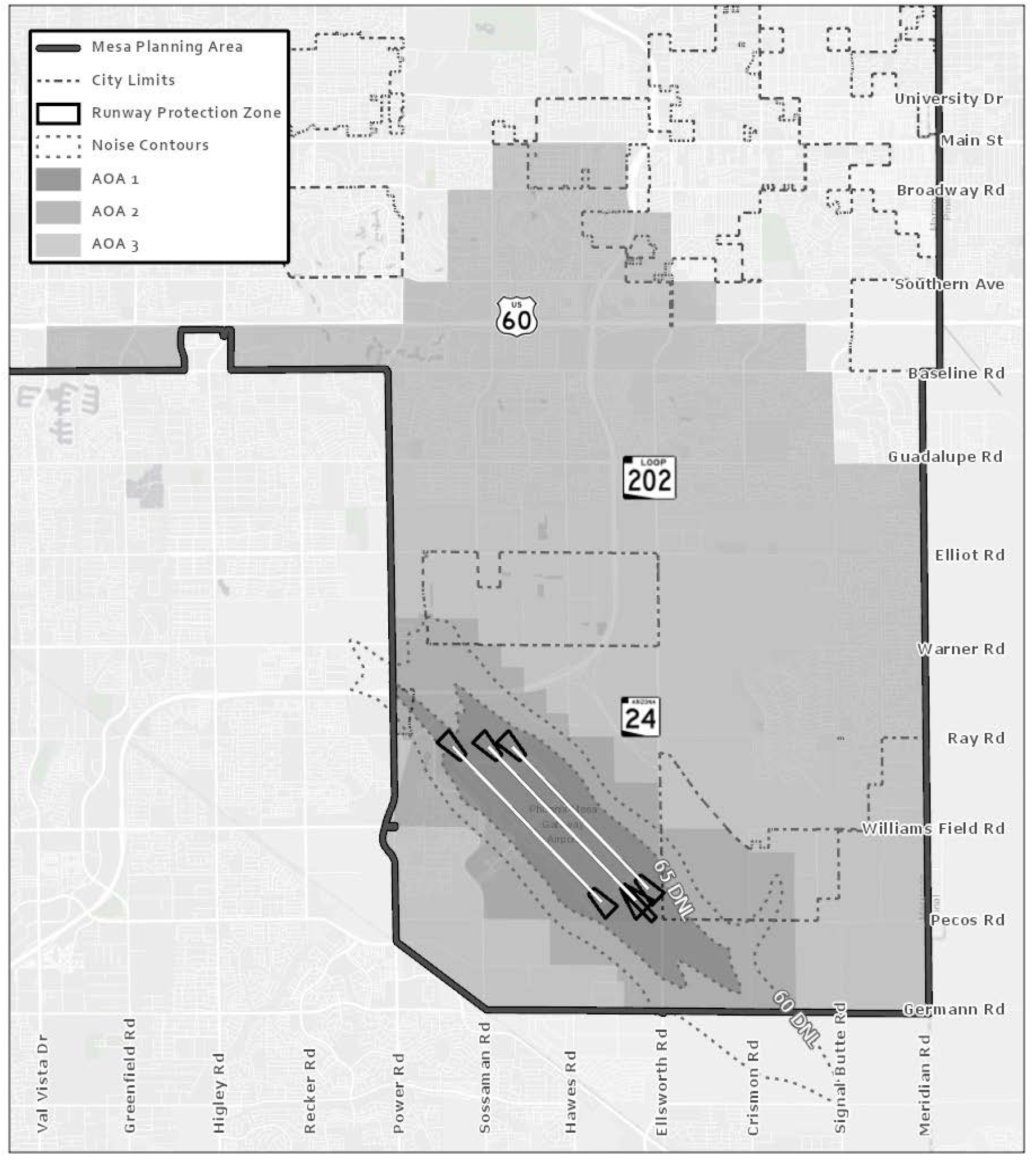
MAP AF-1: AIRFIELD OVERLAY - PHOENIX-MESA GATEWAY AIRPORT
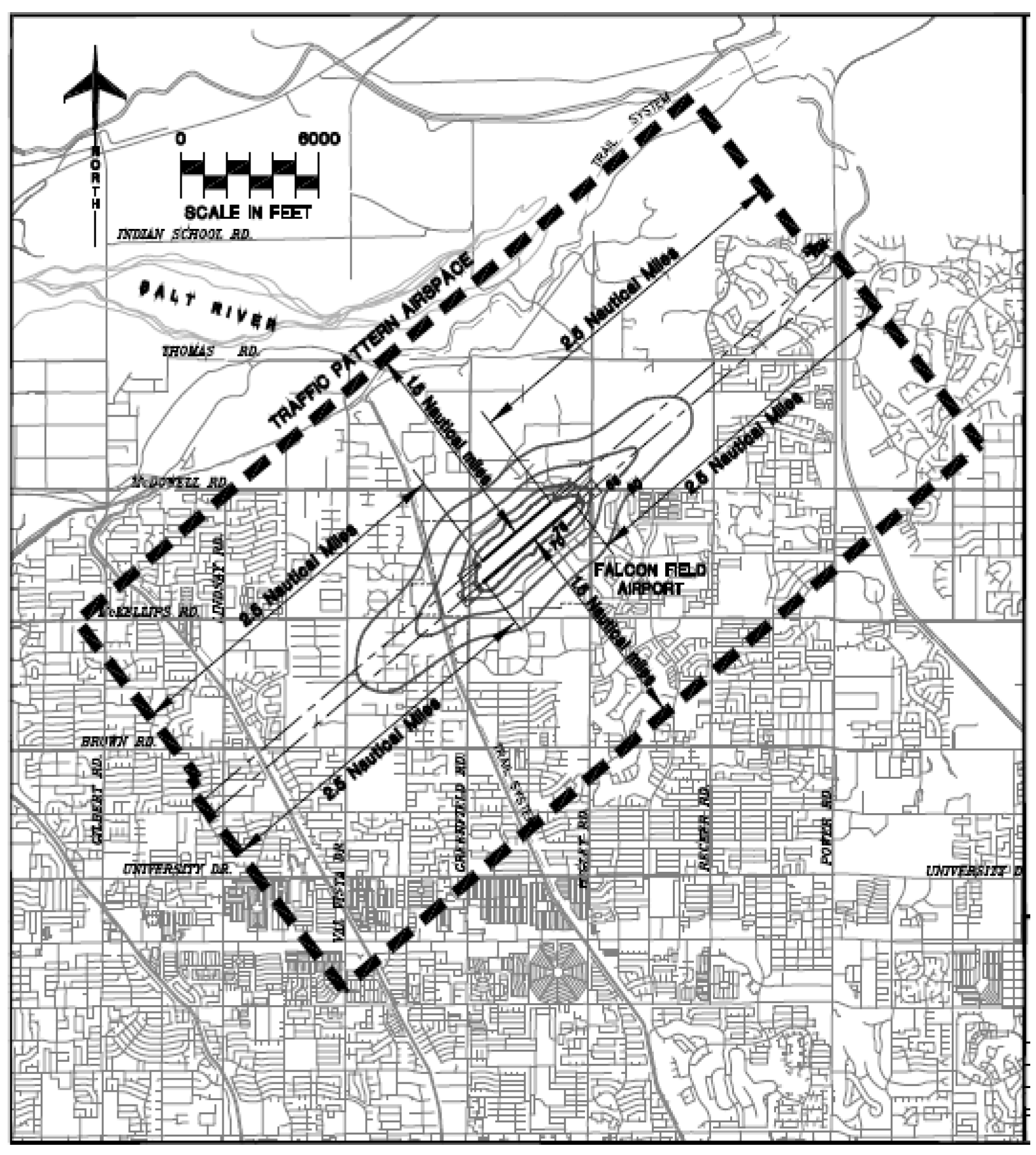
MAP AF-2: AIRFIELD OVERLAY - MESA-FALCON FIELD
AIRPORT
B.
Uncertainty of Boundaries. Where uncertainty exists as to the boundaries of the Runway Protection Zones and Airport Overflight Areas shown on map AF-1 or AF-2, the following rules shall apply:
1.
Boundaries shall be scaled from the nearest physical feature shown on the map, such as roads and canals;
2.
Boundaries on the map shall be scaled from the nearest lot line; or
3.
Distances not specifically indicated on either map AF-1 or Map AF-2 shall be determined by a scaled measurement on the map.
C.
Where physical features on the ground differ from the information shown on Maps AF-1 or AF-2, or when there arises a question as to how or where a parcel of property is zoned or in which Runway Protection Zone or Overflight Area the property is located and such questions cannot be resolved by the application of the above rules, the property shall be considered to be classified as the more restrictive Runway Protection Zone or Airport Overflight Area.
D.
Where a parcel of land lies within more than one (1) Runway Protection Zone or Airport Overflight Area, the Runway Protection Zone or Airport Overflight Area within which each portion of the property is located shall apply individually to each portion of the development.
(Ord. No. 5446, 6-4-18)
11-19-3: - DEFINITIONS SPECIFIC TO AIRFIELD OVERLAY DISTRICTS
Aircraft: Any contrivance, now known or hereafter invented, for use or designed for navigation of or flight in the air, including helicopters, fixed-wing aircraft and gliders, and lighter-than-air vehicles, such as hot-air balloons, blimps and dirigibles.
Airport: The Phoenix - Mesa Gateway Airport owned and operated by the Phoenix- Gateway Airport Authority, or Falcon Field Airport, owned and operated by the City of Mesa, as may be applicable. Airports (plural) refers to both places.
Airport Overflight Area: The areas described in technical studies of airport operation order Federal Aviation Administration (FAA) procedures. The entire Airport Overflight Area consists of 3 Airport Overflight sub-areas: Area One, Area Two and Area Three.
Airport Overflight Area One (AOA 1): The area within the 65 DNL contour.
Airport Overflight Area Two (AOA 2): The area between the 60 and 65 DNL noise contours, as "squared off" by addition of an additional one-half mile for ease of application.
Airport Overflight Area Three (AOA 3): The area outside the 60 DNL contour area as defined by Airport Overflight Area Two, which extends to the balance of the Airport Overflight Area.
Airport hazard: Any structure or object of natural growth, use of land, or other item classified by the FAA as an obstruction to the airspace required for the flight of aircraft arriving at, or departing from, the Airport.
Avigation easement: An easement granted for aviation purposes over and across a property which acknowledges the property will be subject to aircraft overflights and which holds the City, the public and either of the Airports harmless from any damages caused by noise, vibration, fumes, dust, fuel, fuel particles, or other effects that may be caused by aircraft landing, departing or operating at or near either of the Airports, not including the physical impact of aircraft or parts thereof.
DNL (Day-Night Level): The 24-hour average sound level in A-weighted decibels, obtained after the addition of 10 decibels (dB) to sound levels for the periods between 10:00 P.M. and 7:00 A.M. as averaged over a span of 1 year. It is the Federal Aviation Administration (FAA) standard metric for determining the cumulative exposure of individuals to noise.
Decibel (dB): A standard measure of sound intensity, sound power or sound pressure equal to 20 times the common logarithm of the ratio of the pressure produced by the sound wave to a reference pressure, usually 0.0002 microbar.
Noise Level Reduction (NLR): The reduction of outside noise transmitted inside a structure achieved through the incorporation of noise attenuation into the design and construction of the structure.
Noise sensitive uses: Those activities considered to be adversely affected by high noise levels including, but not limited to: single residence or multiple residence housing, hotels, motels, hospitals, nursing homes, places of worship, libraries, public and private schools, standalone day care centers, and places of public assembly.
Runway: A defined area on an airport prepared for landing and takeoff of aircraft along its length. The runway includes any proposed runway or runway extension as shown on the most current Phoenix - Mesa Gateway Airport Layout Plan, Falcon Field Airport Layout Plan, or any other Council approved airport planning document.
(Ord. No. 5446, 6-4-18)
11-19-4: - LAND USE REGULATIONS
A.
Runway Protection Zones (RPZ). In order to minimize public exposure to accident hazard and crash potential as generated by aircraft operations, no building shall be located within any portion of a runway protection zone as defined and designated by this Code. However, such onsite improvements as vehicle parking, storm water retention, landscaping, and yard setbacks, as otherwise required by this Code or other city regulation, may be permitted within the designated runway protection zones. No element of any landscaping shall be allowed to penetrate any runway protection zone slope or other approach surface.
B.
Airport Overflight Areas One and Two (AOA 1, AOA 2). Use limitations are imposed for the AOA 1 and AOA 2 Overflight Areas as shown in the district Land Use Regulation Tables, See Tables 11-4-2, 11-5-2, 11-6-2, 11-7-2, and 11-10-2.
C.
Airport Overflight Area Three (AOA 3). For areas within the AOA 3 Overflight Area, there are no use limitations beyond those in the base district.
11-19-5: - SUPPLEMENTARY PROVISIONS
A.
Avigation Easement. The owners of any property, including mortgagees, other lien holders and easement holders, located within the Airfield Overlay District shall execute an avigation easement prior to or concurrently with the recordation of any subdivision final plat, or issuance of any building permit, whichever occurs first. The easement shall be in a form approved by the Mesa Planning Director and City Attorney. This easement shall hold the City, the public and the associated Airport harmless from any damages caused by noise, vibration, fumes, dust, fuel, fuel particles, or any other effects that may be caused by aircraft landing, departing or operating at or near a designated Airport, not including the physical impact of aircraft or parts thereof.
B.
Notification of Buyers. No person shall sell or offer for sale any property located within the Airfield Overlay District unless the prospective buyer has been notified of the fact that the property is located within the Airfield Overlay District.
C.
Disclosure. The following notice shall be provided in accordance with paragraphs one (1) and (2) below for all single and multiple residence housing and other noise sensitive uses. "This property, due to its proximity to a designated Airport, will experience aircraft overflights, which is expected to generate noise levels that may be of concern to some individuals. The mix of aviation activities and types of aircraft expected to be located at the airport now and in the future may include: scheduled and unscheduled commercial charters, commercial air carriers and commercial air cargo operations, all of which are expected to use large commercial aircraft, corporate and executive jets, helicopters, general aviation aircraft, aviation flight training schools using training aircraft and high performance military jets. The size of aircraft and frequency of use of such aircraft may change over time depending on market and technology changes."
1.
Final Subdivision Plats and Public Reports. For all areas within an AF overlay district, final subdivision plats and public reports filed with the Arizona Department of Real Estate shall provide notice that discloses the location of the Airport and the potential for aircraft overflights and objectionable aircraft noise and shall include, at minimum, the disclosure in Subsection C above.
2.
Real Estate and Similar Sales and Leasing Offices. Sales and leasing offices shall provide notice to all prospective buyers and lessees stating that the project is located within an Overflight Area. Such notice shall consist of a sign at least 4-foot × 4-foot installed at the entrance to the sales office or leasing office at each project. The sign shall be installed prior to commencement of sales or leases and shall not be removed until the sales office is permanently closed or leasing office no longer leases units in the project. The sign shall state the disclosure in Subsection C above letters of at least 2" in height.
D.
Noise Level Reduction. A building permit shall not be issued for any structure requiring a Certificate of Occupancy or designed for habitation, within the Airfield Overlay District, until the plans and specifications accompanying the application for the building permit have been certified by a registered Professional Engineer or registered Professional Architect in the State of Arizona as demonstrating that indoor noise levels attributable to airport operations shall not exceed 45 db for all portions of a structure where the public is received, office areas, public assembly rooms, sleeping areas, noise-sensitive areas and other areas where the ambient noise level is expected to be low. Plazas, courtyards, outside displays, covered/partially enclosed work areas, storage areas, loading bays, and similar areas are excluded.
E.
Provisions. Notwithstanding any other provisions of this Chapter and in compliance with CFR 14 Part 77, no use may be made within any area affected by this Chapter in such a manner as to obstruct navigable airspace, interfere with navigational signals, impair radio communication between the Air Traffic Control Tower and aircraft, impair visibility in the vicinity of the Airport, create bird strike hazards, or otherwise materially endanger or interfere with the landing, takeoff, operation or movement of aircraft.
(Ord. No. 4059, 4-7-03; Ord. No. 4105, 9-22-03; Ord. No. 4157, 2-17-04; Ord. No. 4193, 5-17-04; Ord. No. 5446, 6-4-18)
11-20-1: - PURPOSE
The purpose of the Age-Specific (AS) Overlay District is to provide a residential environment conducive to the lifestyle and particular needs of senior citizens and retirees. This district is intended to be utilized for existing and proposed planned residential developments developed, advertised, and sold under certain age-specific conditions that contain facilities and services specifically designed to meet the physical and social needs of older persons.
11-20-2: - LAND USE REGULATIONS
A.
The Age-Specific overlay district is to be used in conjunction with an underlying residential zoning district, thereby permitting the same uses as the underlying base zoning district.
1.
Each dwelling unit, if occupied, shall be occupied by at least 1 person not less than 55 years of age. Unless a person of not less than 55 years of age also occupies the residence, no person less than 55 years of age shall reside in any dwelling unit for a period of time exceeding 90 days, unless except pursuant to an Administrative Use Permit issued in accordance with Chapter 70, Conditional Use Permits. Evaluation and Issuance of the Administrative Use Permit shall be based on the following criteria:
(a)
The residence has been occupied by some person of not less than 55 years of age within the last 12 months.
(b)
The person that is less than 55 years of age is a spouse or blood relative related to the previous occupant mentioned in (a), above, or listed as a recipient of the estate or trust of the previous occupant.
2.
Administrative Use Permit shall be issued for a period no greater than one year, and shall be renewable.
11-20-3: - SUPPLEMENTAL REGULATIONS
A.
An application for Age-Specific overlay zoning may be approved by the City Council only after submission of the following materials:
1.
A petition signed by 100 percent of the owners of property within the proposed district; or
2.
Documentation that all of the property within the proposed district has been, and will continue to be, developed, advertised, and sold or rented under specific age restrictions; and
3.
Documentation of the existence and availability of facilities and services designed to meet the physical and social needs of older persons.
B.
Age-Specific overlay zoning district may be established only on parcels of 40 or more contiguous acres.
11-21-1: - PURPOSE
The purpose of the Bonus Intensity Zone (BIZ) Overlay District is to provide for variation from the application of residential densities and other development standards to allow greater intensity of development and encourage unique, innovative developments of superior quality. It must be demonstrated that the resulting development will further the goals and objectives of the General Plan, Specific Plans, and Council policies and will provide significant social or economic benefits to the City. This overlay district applies more frequently to individual projects which may consist of one or more buildings. Moreover, the purposes of this district are to:
A.
Encourage unique, innovative development of superior quality that utilizes sustainable development practices and promotes pedestrian activity.
B.
Allow for the establishment of unique land use regulations and development standards to achieve the goals of the General Plan for the area.
C.
Promote development patterns that encourage conservation of natural resources and provide opportunities for renewable energy production.
11-21-2: - LAND USE REGULATIONS
The BIZ overlay-zoning district is used in conjunction with an underlying zoning district, thereby permitting the same uses as the underlying base zoning district, except those land uses that may be excluded by the City Council. Before the City Council excludes a land use from a base zoning district, a development agreement that also excludes those specified land uses shall be adopted previous to or concurrently with the adoption of the overlay district.
11-21-3: - DEVELOPMENT STANDARDS
A.
Unless specifically modified by the City Council, the specified development standards are based upon the requirements of the underlying base zoning district; including but not limited to minimum lot area, maximum density, maximum building height, minimum setbacks, and maximum lot coverage for each underlying zoning district.
B.
The City Council may approve modifications to the underlying district standards proportionate to number of items and degree of compliance provided by projects that comply either with a combination of Items 1 and 2, below; or with a combination of 1 and 3, below. Projects with few modifications need comply with a lower percentage of criteria. Projects with a higher number and greater deviation from adopted standards shall comply with a higher percentage of criteria.
1.
Provide distinctive, superior quality designs. (See Section 11-31-32, Superior Design)
2.
Address environmental performance standards outlined below:
a.
Site selection criteria. Sites shall meet one or more of the following criteria.
i.
Redevelop and rehabilitate economically distressed properties (particularly greyfield sites), damaged sites or environmentally contaminated 'brownfield' sites.
ii.
Utilize areas with existing utility and transportation infrastructure and existing community services. This criterion is preferred for higher density and higher intensity development, when feasible.
iii.
Utilize locations within ½ mile of a planned light rail line or ¼ mile from an existing or planned bus stop. This criterion is preferred for higher density and higher intensity development, when feasible
b.
Site design criteria. Designing the site to facilitate alternative modes of transportation and to reduce onsite environmental impacts.
i.
Provide safe and secure storage for bicycles. For commercial, employment or institutional projects, bicycle storage areas shall be within 200 yards of the building entrance, and shall have a designated and convenient pedestrian access route connecting the storage area to the building. For residential projects, safe and secure bicycle storage areas shall be provided on-site for a minimum 15% of the residents.
ii.
Include priority location parking for low-emission vehicles in parking areas.
iii.
Provide priority location parking spaces for carpool or vanpool vehicles.
iv.
Provide the number of parking spaces designed to serve a development site consistent with the number of spaces required to meet the minimum parking ratio. Parking spaces over the minimum number is discouraged.
v.
For greenfield sites, protect or restore natural areas on site with native vegetation to encourage biodiversity and for enjoyment by people. For previously developed sites, restore areas with native or adapted vegetation to encourage biodiversity and for enjoyment by people. The size of the space should be appropriate for the size of the site and the activity level or use of the site.
vi.
Design the project to be energy efficient including, but not limited to, designed to reduce summer heat gain, reduce winter heat loss, utilize day lighting strategies and provide the opportunity for occupants to take advantage of renewable energy. The design also mitigates the effects of solar exposure for users and pedestrians. For purposes of this criterion, buildings that have efficient HVAC systems, incorporate passive solar heating, cooling and day lighting strategies within an efficient building envelope, as recommended by the Department of Energy's Energy Efficiency and Renewable Energy (EERE) section, including buildings designed to earn the EPA ENERGY STAR or designed to meet LEED™ Silver or equivalent third-party criteria are considered to be energy efficient and no higher standard shall be used
c.
Provide documented evidence that the building(s) will meet or exceed nationally recognized environmental performance standards. For purposes of this criterion, buildings that are designed to earn LEED™ Silver, Green Globes, and/or equivalent third-party criteria, and no higher standard shall be required. Avoid sites considered inappropriate, such as prime farmland, land identified as habitat for endangered species, and wetlands or riparian areas associated with wildlife.
d.
Utilize areas with existing utility and transportation infrastructure and existing community services. This criterion is preferred for higher density and higher intensity development, when feasible.
e.
Redevelop and rehabilitate economically distressed properties (particularly greyfield sites), damaged sites or environmentally contaminated 'brownfield' sites.
f.
Utilize locations within ½ mile of a planned light rail line or ¼ mile from an existing or planned bus stop. This criterion is preferred for higher density and higher intensity development, when feasible.
3.
Provide documented evidence that the building(s) will meet or exceed nationally recognized environmental performance standards. For purposes of this criterion, buildings that are designed to earn Green Globes, LEED™ Silver, or to be in compliance with the International Green Construction Code and/or equivalent third-party criteria, are considered to be energy efficient and no higher standard shall be required.
11-21-4: - SUPPLEMENTAL REGULATIONS
A.
Land developed under this Chapter may consist of building(s) on individual or multiple lots.
B.
Common open space shall be an essential element of the plan. Open areas should provide an efficient, aesthetic, and desirable usage.
C.
Every structure containing residential, commercial, or industrial units shall have access to a public street. The access shall occur either directly to an abutting public right-of-way, or by use of a recorded access easement, or by utilizing a court, walkway, or other common area. If a common area is used, it shall be owned and maintained in common by a property owner's association organized through private covenants, conditions and restrictions attached to the deed.
11-21-5: - REVIEW OF PLANS
A.
Application. Requests for BIZ overlays shall follow the same procedures specified for zoning amendments in Article 7, Administration of this Ordinance.
B.
Modifications to Plans. Changes to the approved development plan shall be reviewed and approved in accord with Chapter 67 Common Procedures.
C.
Building Permits and Regulations.
1.
An approved development may be built in phases upon approval of a phasing plan. Any phasing plan must provide, at a minimum, that the construction and provision of all necessary elements associated with that phase, including parking, drainage, common open spaces, and public and recreational facilities, which are shown on the approved site plan, are constructed prior to or contemporaneously with the construction of buildings for that phase. If the City Manager or designee determines that the rate of building construction does not conform to the approved phasing plan, he shall notify the developer that no new building permits shall be issued until the developer obtains approval of a supplemental Phasing Plan designed to restore compliance with the previously approved Phasing Plan. In the alternative, the developer may submit a proposed revision to the Phasing Plan for Planning Director review and possible approval. Failure to comply with the terms of this Section in a timely manner following notification shall result in all building construction being halted and all existing building permits shall be suspended until a supplemental or revised Phasing Plan is approved by the Planning Director.
2.
When the project has been completed, the use of the land and the construction, modification, or alteration of any buildings or structures within the development shall remain in conformance with the development plan, except that any minor extension, alteration, or modification of existing buildings or structures may be authorized by the Zoning Administrator or Board of Adjustment in accordance with Article 7, Administration of this Ordinance if they are consistent with the purpose and intent of the approved development plan.
11-22-1: - PURPOSE
The purpose of the Planned Area Development Overlay (PAD) District is to permit flexibility in the application of zoning regulations by allowing modifications to land use regulations and development standards in order to:
A.
Support innovative, high-quality, cohesive development.
B.
Facilitate creative land planning that results in superior design outcomes that may not be achievable under conventional zoning regulations.
C.
Elevate the overall quality of development by fostering design excellence and promoting sustainable, livable, and well-connected communities.
Because the PAD Overlay District may be tailored to an individual proposed development, relative to land use regulations and development standards, each PAD Overlay District may differ considerably from another. However, developments within a PAD Overlay District should exemplify:
A.
Thoughtful building, site, and land use planning that creates a unique sense of place and enhances the image and character of the area.
B.
Well designed, accessible, and integrated open space, amenities, and/or recreational facilities of a scale that is proportionate to the use.
C.
High-quality architectural and site design that retains functional relevance, aesthetic appeal, and structural integrity over time.
D.
A balanced mix of land uses that are compatible with each other and surrounding development.
(Ord. No. 5957, § 3, 7-8-25)
11-22-2: - LAND USE REGULATIONS
The PAD overlay district shall be used in combination with one (1) or more underlying zoning districts and may modify land use regulations as follows:
A.
Permit and prohibit the same land uses and activities as the underlying base zoning district(s).
B.
Permit additional land uses not otherwise permitted in the underlying base zoning district(s), as determined by the City Council.
C.
Restrict or prohibit specific land uses to ensure compatibility with surrounding areas and community objectives, as determined by the City Council. To restrict or prohibit land uses in the PAD Overlay District, a development agreement that restricts or prohibits those specified land uses shall be adopted previous to or concurrently with, the adoption of the PAD Overlay District.
(Ord. No. 5957, § 3, 7-8-25)
11-22-3: - DEVELOPMENT STANDARDS
A.
Minimum Site Area. The minimum site area for a PAD shall be five (5) acres. Residential and mixed-use applications for sites that are smaller than five (5) acres may be considered in the event the project includes a minimum of 20 dwelling units.
B.
Compliance with Development Standards. The general development standards established in this Ordinance and the specific development standards for each underlying base zoning district are required, unless specifically modified by the City Council with the approval of the PAD Overlay District.
C.
Standards for Specific Uses.
1.
When a PAD Overlay District is used to permit a land use that is not otherwise permitted in the underlying base zoning district, the land use shall comply with the applicable development standards set forth in Title 11, Chapter 31: Standards for Specific Uses and Activities; and
2.
If no specific development standards exist in Title 11, Chapter 31 for the proposed land use, the City may require additional development standards with the approval of the PAD Overlay District as necessary to ensure compatibility with surrounding uses and to mitigate any potential adverse impacts.
(Ord. No. 5957, § 3, 7-8-25)
11-22-4: - SUPPLEMENTAL REGULATIONS
A.
The submitted plan shall list permitted development and land use options, which may be assigned to specific parcels. Multiple development and land use options may be assigned and described as available alternatives. Land developed under this Chapter may consist of multiple parcels or may have common building sites.
B.
Common open space shall be an essential and major element of the plan. Open areas should provide an efficient, aesthetic, and desirable usage.
C.
Every structure shall have access to a public street, directly across either a coterminous property line; or using recorded access easements; or using a court, walkway or other common area owned and maintained as common ground.
11-22-5: - REVIEW OF PLANS
A.
Application. Requests for PAD overlays shall follow the same procedures specified for zoning amendments in Chapter 76, Zoning Ordinance: Amendments to Map and Text, of this Ordinance. In addition, applications requesting PAD overlays shall include a planning document(s) that incorporates the following items:
1.
Graphic depictions of the following, as may be applicable:
a.
Land use plan, drawn to scale, including:
i.
Dimensions and acreage of overall project site;
ii.
Dimensions and acreage of each underlying zoning district;
iii.
Dimensions and acreage of each unit or stage of development; and,
iv.
Locations of properties proposed for conceptual and specific review.
b.
Site Plan(s), drawn to scale, including typical lot sizes and building placement for residential development (Site Plans not required for conceptual requests).
c.
Elevation(s) of proposed building(s), drawn to scale (Elevations not required for conceptual requests).
d.
Locations of commonly owned, property, including open space and recreational amenities.
e.
Locations of all proposed streets alignments and subdivisions of land.
2.
Narrative description(s) and explanation(s) of the following:
a.
Compliance of the proposed project with the requirements of the Mesa General Plan, and the Purpose statements of the PAD Overlay District (Section 11-22-1).
b.
Development standards for the project, including how proposed deviations from base zoning district development standards and general development standards are of equal or superior quality.
c.
Phasing plans, if the project consists of multiple units or stages of development.
d.
Specific and/or conceptual land uses, as applicable.
e.
Properties and amenities to be held in common ownership, including open space and recreational amenities.
f.
Intensity of development expressed as a ratio (specific plan) or as a range (conceptual plan).
g.
Description of design themes and character.
h.
Incorporation of sustainable development practices.
B.
Conceptual and Specific Plans. Applications for PAD Overlay may specify the project is proposed for conceptual and/or specific approval.
1.
Requests for Conceptual Plan approval permits submittal of generalized plans describing land uses and development themes, and ranges of intensity of development described as ratios of activity, such as floor area ratio or dwelling units per acre. Approved Conceptual Plans require review and approval of a Specific Plan prior to development.
2.
Requests for Specific Plan approval requires submittal of detailed drawings of the proposed development, including site plans, landscape plans and building elevations, depicting the project as it is anticipated to be constructed on the specific location. Specific Plans may be approved by the Planning & Zoning Board in the event a Conceptual Plan has been approved by the City Council, and the submitted Specific Plan indicates the land use is consistent with the range of intensity and other applicable descriptions of development documented on the approved Conceptual Plan or conditions of approval.
3.
The initial submittal for rezoning for the PAD overlay may include both specific plan areas and conceptual plan areas.
C.
Modifications to Plans. Changes to the approved development plan shall be reviewed and processed in accordance with the provisions in Chapter 67 Common Procedures, of this Ordinance.
D.
Phased Development. An approved development may be built in phases as part of the project's plan, if the construction and provision of all necessary elements, including parking, drainage, common open spaces, and public and recreational facilities, which are shown on the approved plan, proceed at a rate commensurate with the construction of buildings. If the Development and Sustainability Department Director determines that the rate of building construction is not commensurate with the construction of the aforementioned necessary elements, the Planning Director or designee shall notify the developer that no permits for building construction will be issued until the rate of construction conforms accordingly. Failure to comply with the terms of this Section in a timely manner following notification shall result in all building construction being halted until compliance is restored.
E.
Conformance with Approved Plan - Modification after Initial Construction. When the project has been completed, the use of the land and the construction, modification, or alteration of any buildings or structures within the development shall remain in conformance with the approved development plan except that any minor extension, alteration, or modification of existing buildings or structures may be reviewed and approved by the Zoning Administrator Hearing Officer or Board of Adjustment in accordance with Chapter 67 Common Procedures, of this Ordinance if the request is found to be consistent with the purpose and intent of the approved development plan.
(Ord. No. 5544, § 5, 12-9-19)
11-23-1: - PURPOSE
The specific purposes of this Chapter are to:
A.
Recognize that the form and character of the City of Mesa are reflected in its cultural, historical, and architectural heritage;
B.
Preserve the unique cultural heritage, to encourage and facilitate public knowledge and appreciation of the past, to foster civic and neighborhood pride, and to encourage public participation in identifying and preserving historical and architectural resources;
C.
Enhance property values, protect and enhance the City's attraction to tourists and visitors, stimulate business and industry, and identify and resolve possible conflicts between the preservation of cultural and historic resources and alternative land uses;
D.
Stabilize neighborhoods through preservation of historic and cultural resources and maintenance of the existing built environment; and
E.
Preserve the diverse architectural styles, patterns of development, and design preferences that reflect phases of the City's history, and encourage complementary contemporary design and construction.
11-23-2: - MESA HISTORIC PROPERTY REGISTER
A.
The Mesa Historic Property Register is hereby established for the purpose of listing the landmarks, historic properties, and historic districts, as designated under the provisions of this Chapter and listed on the National Register of Historic Places. This register, as may be amended from time to time, shall serve as the official record of all such designations and shall be maintained by the Historic Preservation Officer (HPO) and available for public reference at the Office of Historic Preservation.
B.
Supplemental to the historic property register shall be the list of properties classified as historically eligible and archaeologically sensitive. This list, as may be amended from time to time, shall be maintained by the Historic Preservation Officer, and available for public reference at the Office of Historic Preservation.
11-23-3: - APPLICATION FOR HD OR HL
Requests for Historic District (HD) or Historic Landmark (HL) overlays shall follow the same procedures specified for zoning amendments in Chapter 74 and Chapter 76 of this Ordinance. In addition, requests for HD or HL overlays shall also be reviewed by the Historic Preservation Board and a recommendation considered prior to the request being reviewed by the Planning & Zoning Board.
11-23-4: - CRITERIA FOR HISTORIC DISTRICTS AND LANDMARKS
A.
Historic District (HD) Criteria.
1.
Required Minimum Area. An HD overlay district shall have either:
a.
Seven or more properties, whether or not separated by a street; or
b.
At least four or more adjacent and adjoining lots or parcels with at least 300 feet of consecutive street frontage.
2.
Required Historical Elements. An HD overlay district may be established only if at least one (1) of the following exists:
a.
The area meets the criteria for historic districts adopted by the State of Arizona through the State Historic Preservation Office;
b.
The area substantially meets the criteria for the listing of districts to the National Register of Historic Places adopted by the United States Secretary of the Interior, copies of which shall be on file in the Office of Historic Preservation and made available there for public inspection; or
c.
Both of the following are found:
i.
The area possesses a significant concentration, linkage, or continuity of sites, buildings, structures, or objects which are united by past events of 50 or more years ago, or aesthetically by plan or physical development of 50 or more years ago; and
ii.
The area is worthy of preservation and protection for aesthetic interest or value, educational potential, or significance in the history of Mesa.
B.
Historic Landmark (HL) Overlay District Criteria. A building, structure, or object within or without an HP overlay district in the City may be designated as an "Historic Landmark" only if it displays exceptional historic, visual, or architectural significance and at least one of the following exists:
1.
It meets the criteria for historic sites adopted by the State of Arizona through the State Historic Preservation Office;
2.
Any part of it is 50 or more years old; or
3.
It substantially meets the following criteria for individual listing in the National Register of Historic Places adopted by the Secretary of the Interior, copies of which shall be on file in the Office of Historic Preservation:
a.
Value as a significant reminder of the cultural, historical, architectural or archaeological heritage of the city, state, or nation.
b.
Location is the site of a significant local, state or national event.
c.
Identified with a person or persons who significantly contributed to the development of the city, state, or nation.
d.
Identified as the work of a master builder, designer, or architect whose individual work has influenced the development of the city, state, or nation.
e.
Value as a building is recognized for the quality of its architecture, and it retains sufficient elements showing its architectural significance.
f.
Distinguishing characteristics of an architectural style valuable for the study of a period.
11-23-5: - LAND USE REGULATIONS
The HD and HL overlay districts are to be used in conjunction with an underlying zoning district, thereby permitting the same uses as the underlying base zoning district, including those uses that may be specified by the City Council.
11-23-6: - BUILDING PERMITS
Prior to issuance of a building permit for the construction, alteration, rehabilitation, or maintenance of a structure, building, sign, or other object within a designated historic district or historic landmark, the Building Official shall first refer such application to the Historic Preservation Officer for review and approval of a Certificate of Appropriateness as specified in Section 11-74-3. No building permit shall be issued without such Certificate and an issued permit must be in conformance with the requirements specified in the Certificate of Appropriateness.
11-24-1: - PURPOSE AND INTENT
The purpose of this Chapter is to recognize that temporary events of a civic and commercial nature foster and encourage a sense of community. Special events and other temporary activities, such as carnivals, rodeos, festivals, parades and other temporary activities encourage the gathering of citizens of the community for community, civic, recreational, commercial and promotional reasons, when held in the downtown area, benefit the citizens and visitors of Mesa.
(Ord. No. 5862, § 1, 7-8-24)
11-24-2: - DESCRIPTION OF OVERLAY DISTRICT BOUNDARIES
This overlay district shall be the area as shown on Map 11-24-2, and the boundaries of which may be described as:
By a line beginning at the intersection of the west right-of-way line of Country Club Drive and the north right-of-way line of 1st Street; then extending east along the north right-of-way line of 1st Street to the west right-of-way line of Center Street Alley; then extending north along the west right-of-way line of Center Street Alley to the north right-of-way line of 2nd Street; then extending east along the north right-of-way line of 2nd Street to the west right-of-way line of Center Street; then extending north along the west right-of-way line of Center Street to south right-of-way line of University Drive; then extending east along the south right-of-way line of University Drive to the east right-of-way line of Pasadena; then extending south along the east right-of-way line of Pasadena to the south right-of-way line of 2nd Street; then extending west along the south right-of-way line of 2nd Street to the east right-of-way line of Centennial Way; then extending south along the east right-of-way line of Centennial Way to the north right-of-way line of 1st Street; then extending east along the north right-of-way line of 1st Street to the east right-of-way line of Mesa Drive; then extending south along the east right-of-way line of Mesa Drive to approximately 440 feet north of Main Street; then extending east to the west right-of-way line of Lesueur; then extending north along the west right-of-way line of Lesueur to the north right-of-way line of 2nd Street; then extending east along the north right-of-way line of 2nd Street to the east right-of-way line of Hobson; then extending south along the east right-of-way line of Hobson to the south right-of-way line of 2nd Avenue; then extending west along the south right-of-way line of 2nd Avenue to the west right-of-way line of Lesueur; then extending north along the west right-of-way line of Lesueur to the south right-of-way line of Main Street; then extending west along the south right-of-way line of Main Street to the east right-of-way line of Mesa Drive; then extending south along the east right-of-way line of Mesa Drive to the south right-of-way line of 1st Avenue; the extending west along the south right-of-way line of 1st Avenue to the east right-of-way line of Sirrine; then extending south along the east right-of-way line of Sirrine to the south right-of-way line of 2nd Avenue; then extending west along the south right-of-way line of 2nd Avenue to the west right-of-way line of MacDonald; then extending north along the west right-of-way line of MacDonald to the south right-of-way line of 1st Avenue; and then extending west along the south right-of-way line of 1st Avenue to the west right-of-way line of Country Club Drive; then extending north along the west right-of-way line of Country Club Drive and ending at the intersection of the west right-of-way line of Country Club Drive and the north right-of-way line of 1st Street.
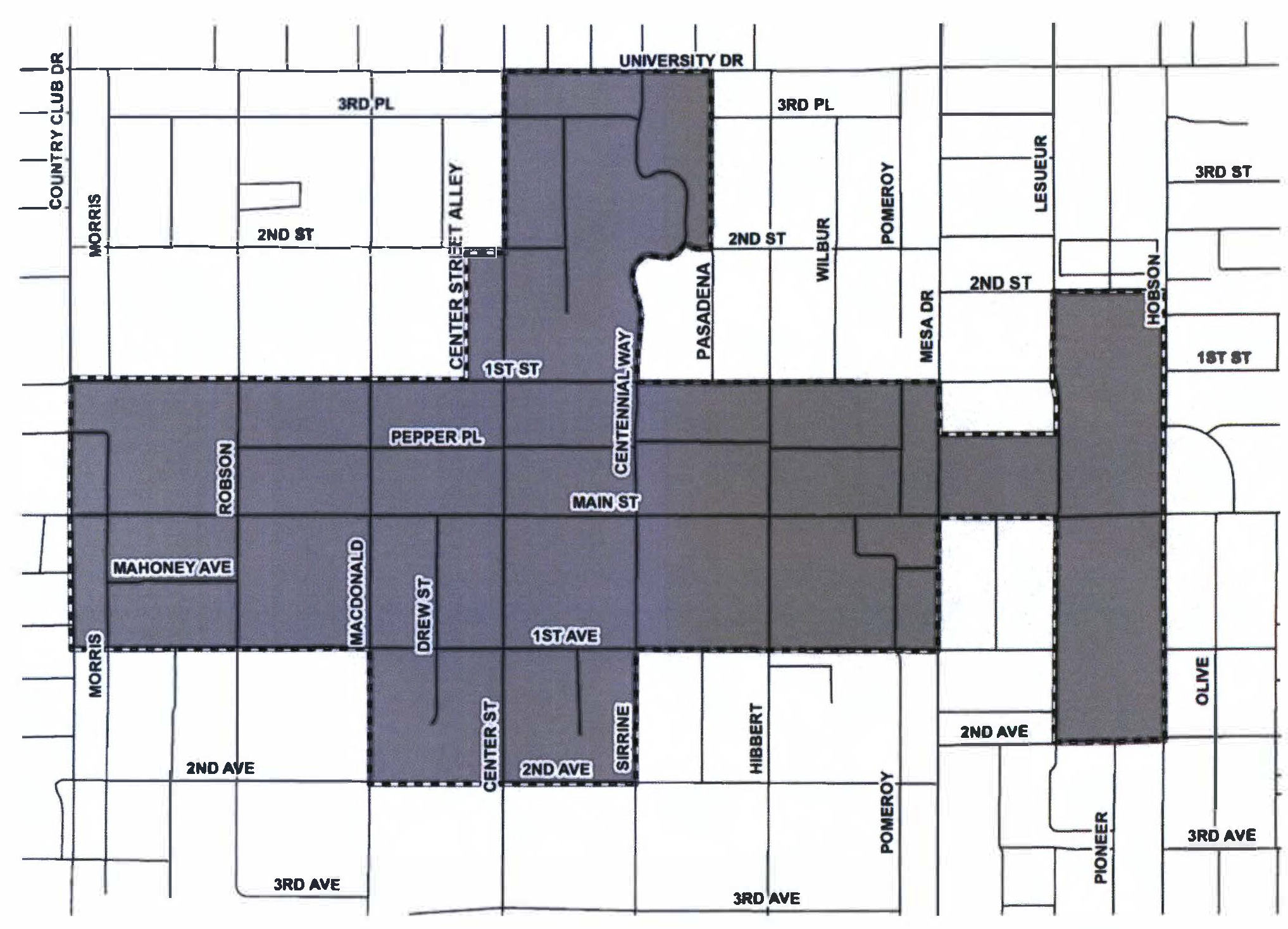
MAP 11-24-2
(Ord. No. 5862, § 2, 7-8-24)
11-24-3: - PERMITTED ACTIVITIES
A.
The number of Special Events, as that term is defined in Chapter 87, held within the Downtown Events Overlay District shall not be limited by the number of events during a calendar year.
B.
Each individual Special Event held within the Downtown Event Overlay District shall be limited to a maximum of 4 consecutive days, unless it is a City-sponsored special event, a City-supported special event, or a temporary use permit or a Special Use Permit is approved in accordance with Chapter 70 of this Ordinance.
(Ord. No. 5759, § 2, 12-8-22; Ord. No. 5862, § 3, 7-8-24)
11-24-4: - SPECIAL EVENT LICENSE REQUIRED
Special events held within the Downtown Event Overlay District shall require approval of a Special Event License, pursuant to Section 11-31-27 of this Ordinance, and in accordance with Title 5, Chapter 1 of the Mesa City Code.
11-25-1: - PURPOSE AND INTENT
The purpose of the Billboard Overlay District is to encourage the development or redevelopment of large or underutilized sites near a Freeway while conserving and promoting public health, safety, and general welfare. The Billboard Overlay District promotes an aesthetically pleasing environment while minimizing distractions for motorists through regulations limiting the location, number, size, and height of Billboards, and requiring spacing, illumination, maintenance, and other development standards for Billboards.
(Ord. No. 5847, § 1, 3-4-24)
11-25-2: - LAND USE REGULATIONS
A.
The Billboard Overlay District shall only be used in conjunction with the Infill Development District-2 (ID-2), Public and Semi-Public District (PS), or Mixed-Use District (MX).
B.
The Billboard Overlay District allows Billboards in accordance with this Chapter and permits the same land uses as the underlying base zoning district, except those land uses that may be excluded by the City Council through a development agreement.
(Ord. No. 5847, § 1, 3-4-24)
11-25-3: - ELIGIBILITY REQUIREMENTS
To be eligible for a Billboard Overlay District, a site must meet the requirements of this Section.
A.
Minimum Site Area.
1.
The site must be at least fifty (50) acres in size.
2.
This requirement may be met by one parcel of land fifty (50) acres or more in size, or a combination of adjoining parcels of land under the same ownership, that are not separated by a right-of-way dedicated to the City, that are collectively fifty (50) acres or more in size.
B.
Minimum Freeway Frontage. The site must have a minimum of 1,500 feet of frontage along a Freeway.
(Ord. No. 5847, § 1, 3-4-24)
11-25-4: - DEVELOPMENT STANDARDS FOR BILLBOARDS
A.
General Development Standards.
1.
Billboards are required to comply with A.R.S. Title 28, Chapter 23, Article 1, and the development standards established in this Chapter.
2.
No deviations from the development standards identified in this Chapter are permitted unless the deviation is more restrictive.
3.
For all other land uses on the site, compliance with the specific development standards for the underlying base zoning district is required and cannot be modified through the Billboard Overlay District.
B.
Setback Requirements. Setbacks for Billboards must adhere to the standards of the underlying base zoning district except for setbacks from the Freeway, in which the following setbacks shall apply:
1.
Minimum Setback from Freeway. The minimum setback to a Freeway right-of-way is zero (0) feet, distance measured from the nearest edge of the Billboard face to the nearest edge of the Freeway right-of-way.
2.
Maximum Setback from Freeway. A Billboard must be located within 250 feet of a Freeway right-of-way, distance measured from the furthest edge of the Billboard face to the nearest edge of the Freeway right-of-way.
3.
Encroachment into Right-of-Way Prohibited. No portion of a Billboard shall overhang or encroach into the right-of-way.
C.
Spacing Requirements.
1.
Billboards or Freeway Landmark Monuments. No portion of a Billboard may be placed within 1,000 feet of another Billboard or Freeway Landmark Monument, including Billboards and Freeway Landmark Monuments located in neighboring jurisdictions, distance measured from the nearest edge of the Billboard face to the nearest edge of the nearest Billboard face or Freeway Landmark Monument face.
2.
Residential Zoning District or Residential Use. No portion of a Billboard may be placed within 500 feet of a Residential Zoning District (RS, RSL, or RM) or residential use unless:
A.
The residential use is part of a mixed-use development; or
B.
A line-of-sight study or balloon test is conducted and demonstrates the Billboard will not be visible to or from any residential use that is not part of a mixed-use development or residential zoning district within 500 feet.
C.
In no case may any portion of the Billboard be placed within 400 feet of a residential use that is not part of a mixed-use development or a residential zoning district.
D.
Number and Size Requirements.
1.
Maximum Number. No more than two (2) Billboards are permitted within a Billboard Overlay District.
2.
Billboard Sign Area.
a.
Maximum Sign Area. The maximum sign area of a Billboard is limited to 672 square feet per sign face.
b.
Sign Area Dimensions. The maximum vertical dimension of a Billboard's sign face is fourteen (14) feet and the maximum horizontal dimension of a Billboard's sign face is forty-eight (48) feet.
c.
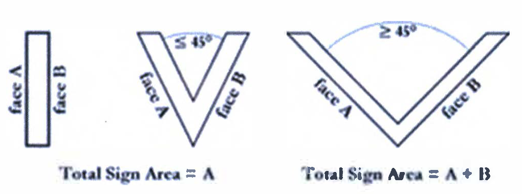
Back-to-Back. Back-to-Back are permitted with the maximum sign area allowed for each face as shown on Figure 11-25-4.C.2.
d.
"V" Shaped Billboards.
i.
A Billboard may be "V" shaped, provided the interior angle between the two sign faces is forty-five (45) degrees or less.
ii.
If the angle between the two (2) sign faces is greater than forty- five (45) degrees, the sign area is the sum of the areas of the two (2) sign faces as shown on Figure 11-25-4.C.2.
e.
Embellishments. A Billboard's maximum sign area may be exceeded by up to 20% by a Billboard embellishment.
f.
Standards of Measurement for Billboards and Embellishments. Billboards and embellishments shall be measured by the smallest square, rectangle, triangle, circle or combination of the smallest square, rectangle, triangle, or circle that will encompass the entire Billboard or the entire embellishment, excluding base or apron supports, pylons, and other structural parts.
3.
Billboard Height.
a.
The maximum height of a Billboard, including any supporting structures, attachments, and embellishments, shall not exceed 60 feet.
b.
Height measurement.
i.
If the natural grade at the base of a Billboard is higher than, or at the same grade as the Freeway, the Billboard height shall be measured as the vertical distance from the average elevation of the natural grade within a 50-foot radius from all sides of the Billboard base to the highest point of the Billboard.
ii.
If natural grade at the base of a Billboard is lower than the grade of the Freeway or has been reduced to provide a storm water retention basin, the height of the Billboard shall be measured from the Freeway elevation to the highest point of the Billboard.
E.
Auditory Effects. Auditory effects, including music, are prohibited as part of any Billboard.
F.
Electronic Billboard Requirements. Electronic Billboards must comply with the following:
1.
Copy Change. Copy must not change more than once every eight (8) seconds.
2.
Message Animation.
a.
Animation, video, flashing, blinking, or moving lights are prohibited.
b.
In the transition between copy, there must not be any sense of movement from one message to the next.
3.
Malfunction. An electronic Billboard must contain a default design mechanism that freezes copy in one (1) position if a malfunction occurs.
G.
Lighting Controls.
1.
Electronic Billboards.
a.
Evening Illumination. Illumination of electronic Billboards must not exceed 300 nits in full white mode in evening hours (from sunset until 11:00 p.m.).
b.
Automatic Dimming. Electronic message panels must include automatic lighting control technology to dim, control, and vary the intensity of the display based on ambient light conditions (e.g. daytime, nighttime, partial shade, or cloudy conditions) through a photoelectric sensor that detects ambient light levels and automatically adjusts the display intensity to ensure compliance with the maximum nit levels in this Section.
2.
Nighttime Illumination. All electronic and non-electronic Billboard illumination must be extinguished in nighttime hours (from 11:00 p.m. until sunrise), except for amber alerts and emergency messaging.
(Ord. No. 5847, § 1, 3-4-24; Ord. No. 5889, §§ 1, 2, 11-4-24)
11-25-5: - BILLBOARD APPLICATION, PERMITS, AND MAINTENANCE
A.
Application Requirements. The requirements and procedures for submission and consideration of an application for a Billboard permit are provided in Chapter 67, Common Procedures, and must include:
1.
Graphic depictions of the Billboard, in plan and elevation views, including:
a.
A description of the Billboard type and materials used for the Billboard and Billboard structure.
b.
Dimensions of the Billboard defining the proposed Billboard sign area including copy.
c.
Dimensions of the Billboard structure.
2.
A site plan depicting, at a minimum:
a.
The Billboard location.
b.
The Billboard's distance from all property lines.
c.
The Billboard's distance from structures on the site.
B.
Building Permit. A Billboard is required to obtain a permit and comply with all requirements of Title 4, Chapter 1 of the Mesa City Code including the requirements relating to permits, inspections, fees, and penalties.
C.
Maintenance. All Billboards must be maintained according to this Section.
1.
It is unlawful for a Billboard to remain in a damaged or deteriorated condition that constitutes a danger or hazard to public safety or a visual blight.
2.
All Billboards must be maintained to the following standards of structural repair and visual appearance:
a.
All structural and nonstructural components must be positioned and secured in accordance with approved plans for the Billboard;
b.
Any deteriorated, damaged, or weakened components must be promptly repaired or replaced;
c.
All copy and painted surfaces of a Billboard must be free of chipping, peeling, rusting or other oxidation of metals, and fading of colors;
d.
Billboards must be maintained in working order; and
e.
If a permit is required per Title 4 of the Mesa City Code for any Billboard maintenance or repair activities, the permit must be obtained prior to commencing work and all work must be done in accordance with permit requirements.
(Ord. No. 5847, § 1, 3-4-24)
11-25-6: - DEVELOPMENT AGREEMENT OR INTERGOVERNMENTAL AGREEMENT
A.
A development agreement or intergovernmental agreement is required in conjunction with a Billboard Overlay District.
B.
The agreement must be approved prior to or concurrently with the approval of the Billboard Overlay District.
C.
The development agreement or intergovernmental agreement may include, but is not limited to:
1.
Requirements that Billboards, or permission for Billboards to, display public service announcements, public announcements, event announcements, or other announcements.
2.
Removal of an existing Freeway Landmark Monument on the site.
3.
Requirements, standards, or limitations for Billboards which may be established as conditions of approval for the Billboard Overlay District.
(Ord. No. 5847, § 1, 3-4-24)