
Mesa City Zoning Code
ARTICLE 2
BASE ZONES
CHAPTER 4 - AGRICULTURAL DISTRICT[1]
Editor's note— Previously, Chapter 4 derived from Ord. No. 4262, 8-16-04; Ord. No. 4913, 2-17-09; Ord. No. 5025, 2-7-11.
CHAPTER 8 - DOWNTOWN DISTRICTS[2]
Editor's note— Previously, Chapter 8 derived from Ord. No. 3864, 3-5-01; Ord. No. 4970, 1-25-10; Ord. No. 5233, 6-2-14.
CHAPTER 9 - (RESERVED FOR FUTURE USE)[3]
Editor's note— Previously, Chapter 9 derived from Ord. No. 4262, 8-16-04.
CHAPTER 10 - PUBLIC AND SEMI-PUBLIC DISTRICT[4]
Editor's note— Previously, Chapter 10 derived from Ord. No. 4262, 8-16-04.
CHAPTER 12 - ID - INFILL DEVELOPMENT DISTRICTS[5]
Editor's note— Previously, Chapter 12 derived from Ord. No. 4262, 8-16-04.
CHAPTER 13 - (RESERVED FOR FUTURE USE)[6]
Editor's note— Previously, Chapter 13 derived from Ord. No. 4005, 8-5-02; Ord. No. 4006, 8-5-02; Ord. No. 4084, 6-30-03; Ord. No. 4101, 9-22-03; Ord. No. 4134, 1-5-04; Ord. No. 4395, 5-16-05; Ord. No. 4532, 4-3-06; Ord. No. 4681, 4-2-07; Ord. No. 4769, 10-15-07; Ord. No. 5025, 2-7-11.
CHAPTER 14 - EMPLOYMENT OPPORTUNITY DISTRICT[7]
Editor's note—Ord. No. 5962, § 1, adopted September 22, 2025, repealed the former Ch. 14, §§ 11-14-1—11-14-10, and enacted a new Ch. 14 as set out herein. The former Ch. 14 pertained to similar subject matter and derived from Ord. No. 4262, 8-16-04; Ord. No. 4770, 10-15-07.
CHAPTERS 16—18 - (RESERVED FOR FUTURE USE)[8]
Previously, Chapter 15 derived from Ord. No. 3987, 5-20-02; Ord. No. 4075, 6-30-03; Ord. No. 4262, 8-16-04; Ord. No. 4383, 5-2-05; Ord. No. 4770, 10-15-07.
Previously, Chapter 16 derived from Ord. No. 4262, 8-16-04; Ord. No. 4770, 10-15-07.
Previously, Chapter 17 derived from Ord. No. 3689, 11-2-98; Ord. No. 3943, 11-5-01; Ord. No. 4268, 9-7-04; Ord. No. 4615, 11-6-06; Ord. No. 4884, 9-22-08; Ord. No. 4913, 2-17-09.
Previously, Chapter 18 derived from Ord. No. 3546, 11-2-98; Ord. No. 3616, 11-2-98; Ord. No. 3818, 2-22-00; Ord. No. 3911, 7-16-01; Ord. No. 4005, 8-5-02; Ord. No. 4006, 8-5-02; Ord. No. 4024, 11-4-02; Ord. No. 4076, 6-30-03; Ord. No. 4269, 9-7-04; Ord. No. 4294, 11-1-04; Ord. No. 4468, 10-24-05; Ord. No. 4476, 11-21-05; Ord. No. 4497, 12-19-05; Ord. No. 4578, 8-14-06; Ord. No. 4605, 11-6-06; Ord. No. 4648, 12-18-06; Ord. No. 4676, 3-19-07; Ord. No. 4712, 6-25-07; Ord. No. 4769, 10-15-07; Ord. No. 4770, 10-15-07; Ord. No. 4832, 5-5-08; Ord. No. 4970, 1-25-10; Ord. No. 4998, 8-30-10.
11-4-1: - PURPOSE
The purpose of the Agricultural (AG) District is to protect and preserve agricultural lands and related activities in their present character. The intent of this district is to protect agricultural lands from incompatible land uses and urban encroachment. This district encourages the use of land for local food production. This district may also be used as a means to limit premature development, or to assure development of property takes place when suitable infrastructure and adopted plans are in place to support development of the area in a manner consistent with the applicable General Plan designation.
11-4-2: - LAND USE REGULATIONS
In Table 11-4-2, the land use regulations for each Agricultural zoning district are established by letter designations as follows:
• "P" designates use classifications permitted in the Agriculture District.
• "SUP" designates use classifications permitted on approval of a Special Use Permits.
• "CUP" designates use classifications permitted on approval of a Council Use Permits.
• "(x)" a number in parentheses refers to a limitation following the table.
• "TUP" designates use classifications permitted on approval of a Temporary Use Permit.
Use classifications not listed are prohibited. The "Additional Use Regulations" column includes specific limitations applicable to the use classification or refers to regulations located elsewhere in this Ordinance.
(Ord. No. 5249, 10-6-14; Ord. No. 5632, § 1, 7-8-21; Ord. No. 5759, § 1, 12-8-22; Ord. No. 5814, § 1(Exh. 1), 10-16-23; Ord. No. 5976, § 1, 1-12-26)
11-4-3: - DEVELOPMENT STANDARDS
Table 11-4-3 prescribes the Development Standards for the AG district.
(Ord. No. 4754, 9-4-07)
11-4-4: - SUPPLEMENTAL REGULATIONS
A.
Fences and Freestanding Walls.
1.
"Corral fences" for the keeping of livestock are permitted consistent with the standards provided in Section 11-30-4(A)(2), Corral Fences.
2.
In addition, all fences, freestanding walls, and corral fences shall meet the standards of Section 11-30-4, Fences and Freestanding Walls and Section 11-30-14, Visibility of Intersections.
B.
Animal Keeping. Animal-keeping is subject to the following standards in the AG District:
1.
Aviaries and Apiaries.
a.
Buildings or hives for apiaries may not be closer than 75 feet to any neighboring residence.
b.
Pens and structures for aviaries may not be closer than 40 feet to any neighboring residence.
2.
Poultry, Bird, and Egg Farms. Poultry, bird, and egg farms are subject to the following standards:
a.
Pens, buildings, and enclosures other than open pasture may not be located closer than 200 feet to any residential, commercial, or employment district.
3.
Livestock. Commercial breeding, raising, training, and grazing of horses, cattle, sheep, goats, ostriches, and other livestock is subject to the following standards:
a.
Sites must be at least 10 acres in area.
b.
Notwithstanding any other provision of this Ordinance, the number of livestock shall be limited to no more than the maximum number permitted by Title 8, Chapter 6, Article 4(IV) of the Mesa City Code, unless a Special Use Permit is approved by the Zoning Administrator acting as a Hearing Officer, or by the Board of Adjustment.
c.
Pens, corrals, and similar structures may not be closer than 40 feet to any neighboring residence.
d.
Barns, stables and similar buildings used to house animals, not including shade structures open at minimum on 3 sides, may not be closer than 75 feet to any neighboring residence.
4.
With regard to items 1 through 3 of this subsection B, in the event that an animal pen, corral or other structure is located outside of the required separation distance when constructed, and subsequent construction is placed closer than the required separation specified, the item constructed first does not have to move its location unless it is expanded, enlarged, or moved.
C.
Plant Nurseries and Garden Centers. Plant Nurseries and Garden Centers oriented principally towards retail trade require approval of a Special Use Permit and are subject to the following standards:
1.
With or without a garden center, plant nurseries that cater principally towards retail trade shall be located on sites with direct frontage on a street designated by the Mesa General Plan as an arterial or as a mid-section collector.
2.
Total floor area for all buildings, except greenhouses used to raise or display plants, shall not exceed 10,000 square feet.
3.
Items displayed outdoors are limited to plants, soils, gravel, soil amendments and fertilizer.
4.
Development standards shall comply with requirements of the GC-A district, see Table 11-6-3 B.
D.
Building Projections into Required Yards. Building projections of a single residence may extend into required yards, subject to the following standards:
1.
No projection may extend into a public utility easement or closer than 2 feet to an interior lot line.
2.
Awnings, eaves, overhangs, or basement window wells may encroach up to 3 feet into any required yard.
3.
Vestibules, bay windows, nooks, chimneys, or similar wall projections with or without footings may encroach not more than 3 feet into any required front or rear yard and not more than 2 feet into any required side yard, provided the aggregate width of all such projections adjacent to any yard does not exceed 1/3 of the length of the building wall.
4.
Staircases may encroach:
a.
Up to 3 feet into any required front yard,
b.
Up to 10 feet into any required rear yard; and
c.
Up to 2 feet into any side.
5.
Attached open porches, open patios, open carports or open balconies may encroach up to 10 feet into a required rear yard. Such open structures may include window screens, knee walls, and other partial enclosures as specified in the Building Code for patio covers.
(Ord. No. 5544, § 2, 12-9-19)
11-4-5: - AGRICULTURE-BASED ENTERTAINMENT
Agriculture-based entertainment and educational related activities, such as corn mazes, facility tours, petting zoos and farm animal exhibits, are permitted as an accessory use in the AG district subject to review and approval of a Special Use Permits in accordance with Chapter 70, Conditional Use Permits. Evaluation of the Special Use Permit shall be based on a review of the following items to assure the entertainment and educational related activities remain compatible with and not detrimental to surrounding land uses:
A.
Site Plan. A finding that an acceptable site plan has been submitted for review and consideration. Such site plan shall adequately addresses issues relating to vehicle access, traffic circulation, and pedestrian safety.
B.
Parking. Parking, which shall be dustproof, and provided at a minimum ratio of 1 space per 1,000 square feet of designated entertainment area.
C.
Accessory Use. The entertainment and educational activities shall remain as an accessory activity, and the primary uses for the site shall remain agricultural related activities as permitted under Section 11-4-2.
D.
Applicable Policies. The use is found to be in compliance with the General Plan, and with applicable Sub Area Plans, Neighborhood Plans and other recognized development plans or policies, and will be compatible with surrounding uses; and
E.
Operational Plan. A finding that an acceptable operational plan in narrative form has been submitted for review and consideration, which includes, but is not limited to, descriptions of acceptable measures to ensure ongoing compatibility with adjacent uses. Such policies shall include, but are not limited to measures that control: dust, vectors, litter, noise and light. The Operational Plan shall also include the name and telephone number of the manager or person responsible for the operation of the facility; and complaint response procedures, including investigation, remedial action, and follow-up.
(Ord. No. 4262, 8-16-04)
11-4-6: - REVIEW OF PLANS
Administrative Use Permits, Special Use Permits, and Council Use Permits shall follow the standards established in Chapter 70 of this Ordinance. All other uses and development shall comply with the review procedures, standards and criteria established in Article 7, Administration.
(Ord. No. 4262, 8-16-04)
11-5-1: - PURPOSE
A.
General Purpose of Residential Districts. The purposes of the residential districts are to:
1.
Provide for the orderly, well-planned, and balanced growth of residential neighborhoods.
2.
Provide for a variety of housing types in a range of densities.
3.
Promote the development of residential neighborhoods with well-designed transportation links to educational, employment, commercial and recreational destinations, and which encourage multiple methods of transportation, including walking, biking, and the use of public transit.
4.
Establish design standards to help create distinct and attractive residential neighborhoods, upgrade the quality of multi-family housing, and ensure that new residential development is well integrated with surrounding neighborhoods.
5.
Provide for appropriate public and quasi-public uses such as parks, playgrounds, religious facilities, and day care centers where they are compatible with and preserve and/or improve the quality of life in residential neighborhoods.
6.
Provide development patterns that encourage energy conservation and provide opportunities for renewable energy production.
B.
Specific Purposes of Each District.
1.
RS Single Residence. To provide areas for detached single residence housing at densities of up to 7 units per net acre. Designators (-90, -43, -35, -15, -9, -7 and -6) are used to denote the minimum lot size in thousands of square feet. This district also provides for community residences, assisted living homes, day care group homes, park and recreation facilities, and civic and institutional uses such as churches and places for religious assemblies that are appropriate in a residential environment. Non-residential uses of a strictly limited scale under the specific conditions listed may also be allowed.
2.
RSL Small Lot Single Residence. To provide areas for small-lot single dwelling development at densities of up to 17 units per net acre, subject to development standards to ensure land use compatibility. Designators (-4.5, -4.0, -3.0 and -2.5) are used to denote the minimum average lot size in thousands of square feet. This district also allows for community residences, assisted living homes, family day care, park and recreation facilities, and civic and institutional uses.
3.
RM Multiple Residence. To provide areas for a variety of housing types at densities of up to 43 units per gross acre. Designators (-2, -3, -4, and -5) are used to denote variations in the maximum allowed development intensity (See Table 11-5-5). Appropriate types of dwelling units include small-lot single residences, townhouses, cluster housing, and multiple residence housing. This district also provides for community residences, assisted living facilities, residential home-based day care, boarding house manufactured home parks and subdivisions, recreational vehicle parks and subdivisions, park and recreation facilities, limited and small-scale residential support (including limited scale mixed-use commercial) activities, and civic and institutional uses such as churches and places for religious assembly that are appropriate in a residential environment.
(Ord. No. 5541, § 2, 12-9-19; Ord. No. 5632, § 2, 7-8-21)
11-5-2: - LAND USE REGULATIONS
In Table 11-5-2, the land use regulations for each Residential Zoning District are established by letter designations as follows:
• "P" designates use classifications permitted in the Residential District.
• "SUP" designates use classifications permitted on approval of a Special Use Permits.
• "CUP" designates use classifications permitted on approval of a Council Use Permits.
• "TUP" designates use classifications permitted on approval of a Temporary Use Permits.
• "(x)" a number in parentheses refers to a limitation following the table.
Use classifications not listed are prohibited. The "Additional Use Regulations" column includes specific limitations applicable to the use classification or refers to regulations located elsewhere in this Ordinance.
(Ord. No. 5541, § 2, 12-9-19; Ord. No. 5592, § 2, 12-1-20; Ord. No. 5593, § 2, 12-1-20; Ord. No. 5632, § 1, 7-8-21; Ord. No. 5759, § 1, 12-8-22; Ord. No. 5813, § 1(Exh. 1), 10-16-23; Ord. No. 5814, § 1(Exh. 1), 10-16-23; Res. No. 12269, § 2, 9-23-24; Ord. No. 5883, § 3, 10-7-24; Ord. No. 5989, § 1, 12-8-25; Ord. No. 5876, § 2, 1-12-26)
11-5-3: - DEVELOPMENT STANDARDS FOR THE RS AND RSL DISTRICT
A.
Zoning District Standards. Tables 11-5-3.A and 11-5-3.B prescribes the development standards for the RS and RSL Districts. The "Additional Standards" column lists additional standards that apply in some or all districts. Section numbers in this column refer to other sections of the Zoning Ordinance, while individual letters refer to subsections that directly follow the table.
1.
Reductions to Lot Area. Creation of a new lot that is less than the required minimum lot area, as specified below, requires approval of a Planned Area Development (PAD) or Bonus Intensity Zone (BIZ) Overlay. It must be demonstrated that the resulting development will further the goals and objectives of the General Plan, specific plans, and Council policies and will provide significant social or economic benefit to the City.
a.
The minimum lot area by right in the RS district is 6,000 square feet, indicated by the designator RS-6.
b.
The minimum lot area in the RSL District is 4,500 square feet, indicated by the designator RSL-4.5.
2.
Additional Lot Width for Corner Lots.
a.
At Local or Local-Collector Street Intersections. Additional lot width equivalent to ten percent (10%) of the standard lot width for the zoning district shall be provided on the recorded document for corner lots located at the intersection of:
i.
Two (2) local streets, or
ii.
A local street and collector street.
b.
At Arterial and Collector or Arterial and Local Street Intersections. Additional lot width equivalent to 15 percent (15%) of the standard lot width for the zoning district shall be provided on the recorded document for corner lots located at the intersection of:
i.
Two (2) collector streets,
ii.
Two (2) arterial streets, or
iii.
A collector and arterial street.
c.
Lots With 2 or More Intersection Corners. For lots that have more than one (1) corner, the percent of lot increase required will be based on the highest classified intersection.
d.
Lot Depth Adjacent to Arterial Street. Where the rear lot line of a lot in the RS-7 or RS-6 District directly abuts the right-of-way of an arterial street, the minimum lot depth shall be increased by an additional ten (10) feet. Rear lot lines separated from arterial street right-of-way by a separate tract of land with a depth of ten (10) or more feet are excluded from this requirement.
3.
Yards.
a.
Rear Yard Adjacent to Arterial Street. A rear yard adjacent to an arterial street shall be at least 30 feet in depth. If a landscape tract, stormwater retention basin or privately owned and maintained recreation open space separate, any of which is a minimum of ten (10) feet deep from the street, separates the residential lot from the arterial street, this requirement shall not apply.
b.
Rear Yard Adjacent to Alley or Canal. Rear yard setbacks adjacent to a 16-foot or wider alley or canal right-of-way may be measured from the centerline of the alley, up to a maximum of ten (10) feet.
c.
Zero-Lot-Line Developments. Zero-lot-line developments are permitted in the RS-6, RS-7, and RSL Districts.
i.
In a zero-lot-line development, no interior side yard need be provided on one (1) side of a lot if the minimum aggregate setback stated in Table 11-5-3, or ten (10) feet, whichever is greater, is provided on the opposite side of the same lot.
ii.
Where a zero-side yard is used, the abutting property must be held under the same ownership at the time of initial construction, or the owner of the property abutting the zero-side yard must sign an agreement that permanently grants consent in writing to such zero setback. Additionally, owners of zero-lot-line developments must provide a permanent access and maintenance easement providing the owner of the zero-lot-line structure with access to the adjacent lot with the side yard to maintain the structure. A copy of the easement shall be provided to the City prior to recording the document in the Maricopa County Recorder's Office.
d.
Setback Adjacent to RS District. Where a lot in the RSL District is adjacent to a lot in the RS District, the minimum interior side yard (for a single side) that is required on the RS-zoned lot shall also be provided on the lot in the RSL District.
e.
Limitation on Paving of Street-Facing Yards. No more than 50 percent (50%) of any required front or street-facing side yard may be covered with a paved surface.
4.
Third-Story Structures. A single-residence dwelling unit may have a third story subject to the following:
a.
The third story is located inside a roof that is pitched at a vertical to horizontal ratio of least 1 to 3 (1:3). The third story may include dormers that are not more than 15 feet in depth or width and located wholly below the ridge of the roof. The roofs of dormers shall have a minimum slope of 1 to 6 (1:6); or
b.
The horizontal area of the third story (measured from exterior walls) does not exceed sixty percent of the footprint of the building, and the third story is set back a minimum of eight (8) feet from the front exterior wall(s) of lower stories, or set back at least five (5) feet from the front exterior wall and five (5) feet on at least one (1) side exterior wall of lower stories.
5.
RSL Open Space Requirements. The open space requirement in the RSL Districts may be satisfied in one of two ways:
a.
A minimum of 400 square feet of open space shall be provided on each lot. The following criteria apply to the provision of this open space:
i.
The open space may be contained in one (1) large area, or multiple areas. No single space shall be smaller than 80 square feet.
ii.
To count toward the required open space, the open space must have a minimum depth of at least six (6) feet as an upper story balcony, eight (8) feet as a porch or patio and ten (10) feet as a courtyard or lawn area.
iii.
Items such as covered porches or patios, open on two sides; or designated courtyards with two (2) sides defined by a knee wall of not more than three (3) feet in height may be considered as open space when located in front and street-side facing yards, provided the minimum dimension of the open space in any direction is:
(1)
Ten (10) feet in the RSL-4.5, 4.0. and 3.0 districts; and
(2)
Eight (8) feet in the RSL-2.5 district.
b.
A combination of open space provided on the lot and in a common open space areas:
i.
For properties zoned RSL 4.5 or 4.0, the open space requirement may be met by providing at least 350 square feet of private open space on each lot, and providing common open space areas to serve the development at the rate of 100 square feet per lot.
ii.
For properties zoned RSL-3.0 or 2.5, the open space requirement may be met by providing at least 280 square feet of private open space on each lot and providing common open space areas to serve the development at a rate of 120 square feet per lot.
iii.
Minimum open space dimension standards provided above, apply to the size and location of the on-lot open space.
iv.
To qualify as common open space, all of the following standards must be met:
(1)
The area shall be readily accessible and open to the community intended to benefit from the open space;
(2)
The common area must be at least 0.25 acres in size with a minimum usable width of at least 75 feet in any direction;
(3)
The open space must be at least 50 percent (50%) open to the sky. At least 75 percent (75%) of open space areas that are open to the sky and not otherwise used as active recreation facilities shall be landscaped and maintained with live plant materials;
(4)
Open space areas shall be improved with facilities that provide for active and/or passive recreation, such as benches, paths, playground equipment, ball courts, picnic tables, and barbeque facilities; and
(5)
Open space areas shall be centrally located.
B.
Site Planning and Design Standards.
1.
Neighborhood Character and Image. In accordance with the City of Mesa's Design Guidelines, residential subdivisions of five (5) acres or more should be designed so that they are resilient communities that stand the test of time. New developments should be built using a diverse set of materials, access options, colors, architectural styles, and scales. Additionally, streetscapes, parks, parking, and community access should accent the neighborhood through both function and design.
a.
Connectivity. Residential subdivisions shall provide vehicular, pedestrian and bicycle connectivity to adjacent schools, places of work or services, and abutting residential developments.
i.
All development applications must accommodate the street standards and transportation facilities identified by the City's Transportation Plan.
ii.
The street or roadway pattern shall be designed in regards to topography and existing natural features.
iii.
Streets stubbed or platted to the boundary of previously approved development plans shall be incorporated and continued, to provide for logical, orderly, and convenient movement from one neighborhood to the next.
iv.
Sidewalks, trails, and greenbelts shall be utilized to provide pedestrian/bicycle connections between neighboring subdivisions and major activity areas.
b.
Neighborhood Identity and Amenity Features. Open space, recreational amenities, and subdivision features shall be thoughtfully designed and sited as to create a sense of place and foster a sense of community.
i.
Community Character/Monumentation. Provide enhanced entryway design where entry streets intersect arterials or major collectors. Such gateway features provide a sense of arrival through the use of monument signage, special landscaping, specialty pavement, enhanced wall details, architectural tower or arch features and/or water features.
ii.
Perimeter Walls and Fences.
(1)
Perimeter walls along arterial or collector roads in excess of 40 linear feet shall provide articulation through the use of columns, varied heights, and protrusions and recesses in the horizontal plane. Posts or columns must protrude a minimum of six (6) inches from the adjacent plane.
(2)
Perimeter walls along or adjacent to arterial or collector roads shall be constructed of high-quality, durable materials such as stucco finish, textured block, brick, decorative cap block, wrought iron, or other similar high-quality material.
c.
Architectural Variation. Developments shall provide visual interest by providing architectural variety through the use of distinct building elevations, exterior materials, roof lines, garage placement, and building placement. Such variation in buildings shall not consist solely of combinations of the same building features.
i.
For developments consisting of three (3) to nine (9) lots, there shall be at least two (2) different types of building elevations.
ii.
For projects of ten (10) to 39 lots, there shall be at least three (3) different building elevations.
iii.
An additional building elevation shall be provided for each additional 40 lots.
iv.
No two (2) of the same building elevation shall be located next to each other or across the street from one another.
2.
Massing and Scale. Buildings should contain varied massing and scale elements to ensure an interesting streetscape, provide shading, and define different uses and activities in the house.
a.
Façade Articulation.
i.
The front façade of buildings must have at least one (1) change in building plane, exclusive of the garage.
ii.
Two-story Dwellings on Corner Lots. No second-story street-facing wall shall run in a continuous plane of more than twenty feet without a window, or without a projection, offset, or recess of the building wall at least one (1) foot in depth.
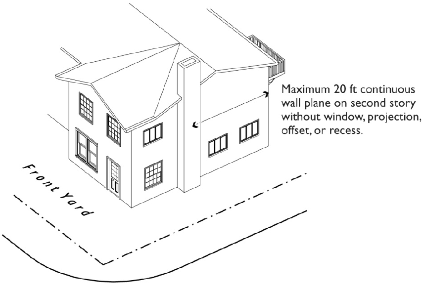
FIGURE 11-5-3.B(1): TWO-STORY DWELLINGS ON CORNER LOT
iii.
Encroachments. Building projections may extend into required yards, subject to the following standards:
(1)
No projection may extend into a public utility easement or closer than two (2) feet to an interior lot line.
(2)
Awnings, eaves, overhangs, or basement window wells may encroach up to three (3) feet into any required yard.
(3)
Vestibules, bay windows, nooks, chimneys, or similar wall projections with or without footings may encroach not more than three (3) feet into any required front or rear yard and not more than two (2) feet into any required side yard, provided the aggregate width of all such projections adjacent to any yard does not exceed one-third (⅓) of the length of the building wall.
(4)
Staircases may encroach up to three (3) feet into any required front yard, and up to ten (10) feet into any required rear yard.
(5)
Attached open porches, open patios, open carports or open balconies may encroach into a required rear yard, but shall be no closer than 15 feet to a rear property line, except in the RS-6 and RS-7 Districts, where these structures may encroach to within ten (10) feet of the rear property line. Such open structures may include window screens, knee walls, and other partial enclosures as specified in the Mesa Building Code for patio covers.
(6)
In RS districts only, enclosed livable rooms may encroach up to ten (10) feet into a required rear yard for up to one-half (½) the width of the building, provided a minimum of ten (10) feet remains between the building face and the rear property line.
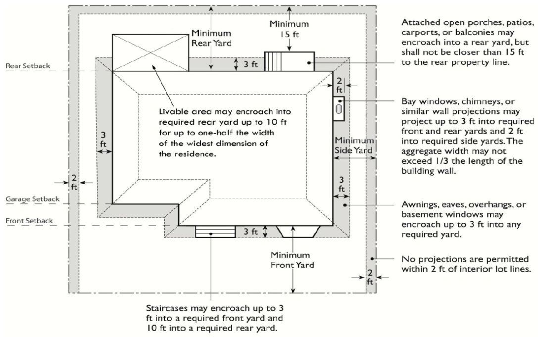
FIGURE 11-5-3.B(2): BUILDING PROJECTION
3.
Primary Entrances. The front entrance should facilitate the transition between public and private spaces and be clearly defined to help orient visitors. Entryways shall consist of:
a.
A front porch with a minimum depth of six (6) feet, as measured from the building façade to the posts, and a minimum length of eight (8) feet; or
b.
A portico, awning, recess, or stoop measuring at least four (4) by four (4) feet which is well defined by a gabled entry, distinct change in roof line or columns, or has some other significant architectural distinction.
4.
Garage Frontage and Location. To prevent residential streetscapes from being dominated by protruding garage doors, and to allow the active, visually interesting features of a house to be dominant, the following standards shall apply:
a.
Front Loaded Garages. Where garage doors face the front property line of the lot, the aggregate width of garage doors shall not exceed 50 percent (50%) of the aggregate width of the front building elevation forward facing garages shall be located at least three (3) feet behind the primary wall facing the street, and never less than the required garage setback. A covered front porch, patio, side loaded carport, or porte-cochere with sufficient size and substantial massing, as determined by the Planning Director, may be considered a wall of the home for the purposes of this requirement. This requirement shall apply to all new homes with plans or product approved after October 2011.
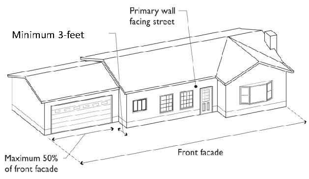
FIGURE 11-5-3.B(3): GARAGE FRONTAGE AND LOCATION
b.
Garages with three (3) or more doors, or designed to accommodate three (3) or more non-tandem parked cars, are permitted only on lots 75 feet wide or greater, and at least one (1) garage front must be separated from the remaining garage fronts by at least two (2) feet. Exceptions:
i.
Garages entries oriented parallel or within ten (10) degrees of parallel to side or rear property lines and that do not directly face a street, or
ii.
Garages set a distance of 1.5 times the minimum front yard for garages and carports, based on the requirement for each zoning district, from the front property line, as specified by Table 11-5-3.
c.
Alternative garage door treatments may be accepted by the Planning Director if:
i.
The configuration of the lot or other physical existing conditions make the application of these standards impractical; and
ii.
The proposed design meets the intent of the Chapter to line streets with active living space, create pedestrian-oriented streetscapes, and provide variety in visual interest in the exterior design of residential dwellings.
5.
Driveways—Maximum Number and Width.
a.
For lots less than 75 feet wide:
i.
A maximum of one (1) driveway up to 19 feet wide is permitted for required parking;
ii.
One (1) additional driveway up to ten (10) feet wide is permitted, if it leads to an interior side yard at least 12 feet wide.
iii.
The combined paved areas do not exceed 50 percent (50%) of the area of the front yard.
b.
For lots greater than or equal to 75 feet wide:
i.
A maximum of one (1) driveway up to 29 feet wide is permitted for required parking; or
ii.
One (1) 19-foot driveway and one (1) additional ten (10) foot driveway which leads to in interior side yard, at least 12 feet in width; and
iii.
The combined paved areas do not exceed 50 percent (50%) of the front yard.
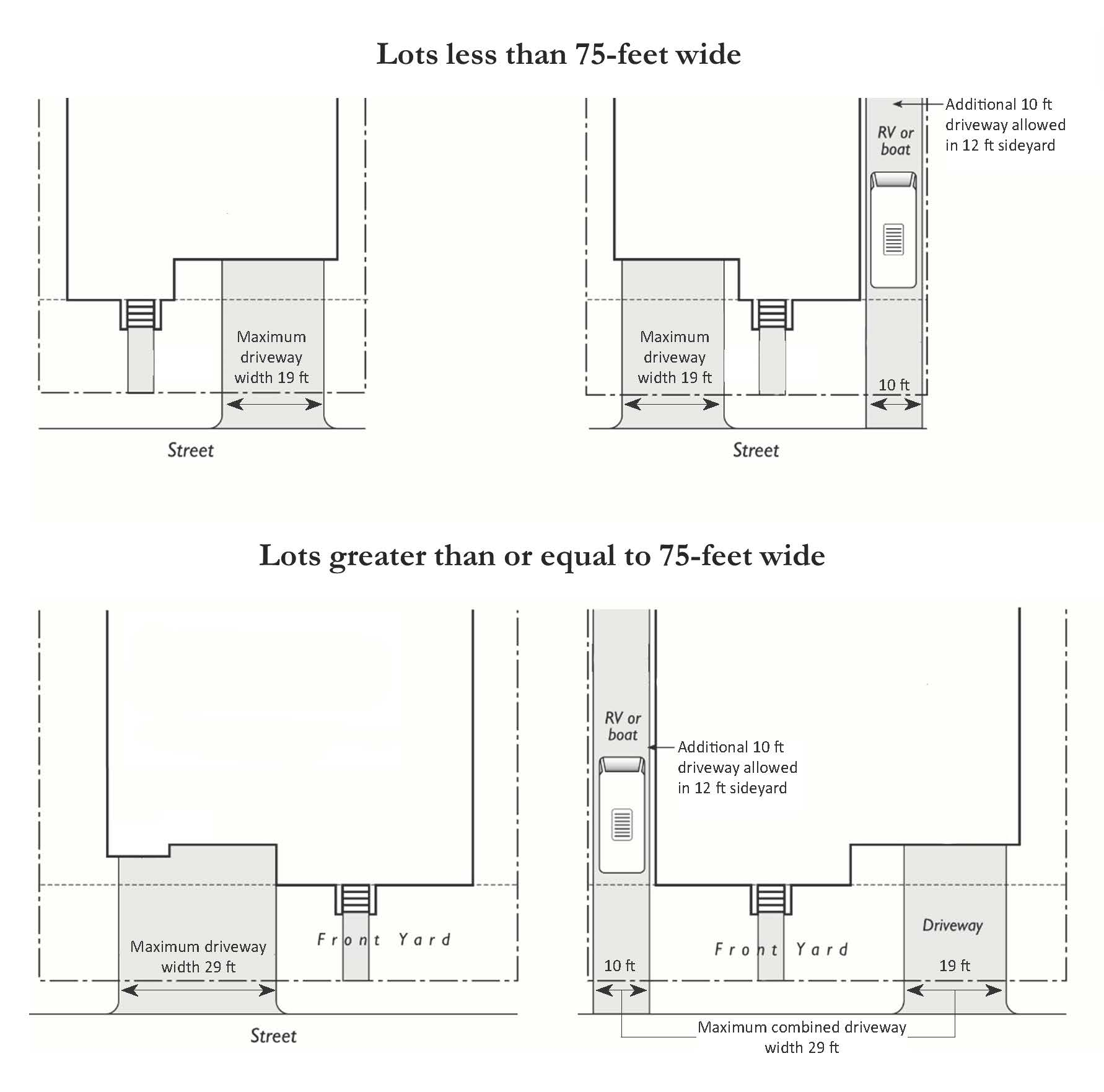
FIGURE 11-5-3.B(4): DRIVEWAYS
6.
Windows.
a.
Window Trim or Recess. On all street-facing facades, trim at least two (2) inches in depth must be provided on at minimum two (2) sides of all windows, or windows must be recessed at least four (4) inches from the outside plane of the surrounding exterior wall. This includes rear facing facades for lots with rear property lines abutting open space, parks, streets or alleys.
b.
Corner Lots. Dwellings located on corner lots shall include windows on the façade facing each street. such window area should constitute at least ten percent (10%) of the façade's area.
7.
Materials. Buildings must contain at least two (2) kinds of primary exterior materials distinctively different in texture or masonry pattern, such as brick, stone, integrally tinted and textured masonry block, precast concrete, wood, natural and synthetic stone, stucco and synthetic stucco.
a.
Any one (1) material must be used on at least 15 percent (15%) of the front façade.
b.
Where brick or stone veneer is used as wainscoting, it shall be wrapped a minimum of two (2) feet around side walls.
8.
Factory-Built Buildings. Factory-built buildings designed, manufactured and approved for residential purposes as dwelling units and attached to permanent foundations are permitted in all residential districts, if such buildings are installed in conformance with all applicable provisions of the Mesa City Code including applicable development standards.
9.
Alternative Compliance. Site Planning and Design Standards are not intended to limit creative solutions. Conditions may exist where strict compliance to Site Planning and Design Standards of this Chapter are impractical or impossible, or where maximum achievement can only be obtained through alternative compliance. Alternative compliance does not modify or reduce requirements of the Building Code or any other chapters or sections of the Zoning Code. Alternative compliance allows development to satisfy the Site Planning and Design Standards in this Chapter by providing comparable standards in a creative way.
a.
Requests for alternative compliance may be accepted for any application to which Site Planning and Design Standards apply. A written request must be provided in conjunction with the applicable land use application describing how the proposed alternative meets the criteria below.
b.
The approving body shall find that the request meets one (1) or more of the following criteria:
i.
Topography, soil, vegetation or other site conditions are such that full compliance is impossible or impractical; or improved environmental quality would result from alternative compliance.
ii.
Space limitations, unusually shaped lots and prevailing practices in the surrounding neighborhood, may justify alternative compliance for bypassed parcels and for improvements and redevelopment in older neighborhoods.
iii.
Safety considerations make alternative compliance necessary.
iv.
The proposed alternative is aesthetically more complementary to the site, better fits into the context of the area, improves the overall architectural appeal of the area and/or meets or exceeds the design objectives as described in the City's General Plan.
(Ord. No. 5593, §§ 3, 4, 12-1-20; Ord. No. 5858, § 1, 7-1-24; Ord. No. 5989, § 2, 12-8-25)
11-5-5: - DEVELOPMENT STANDARDS FOR THE RM DISTRICT
A.
Zoning District Standards. Table 11-5-5 prescribes the development standards for the RM Districts including those districts that may utilize the "U" character designator. Section numbers in this column refer to other sections of the Zoning Ordinance, while individual letters refer to subsections that directly follow the table.
1.
Yards.
a.
Setback Adjacent to RS District. Where a lot located in an RM District is adjacent to the RS District, a single-story building on the RM-zoned lot shall be set back from the RS District property line at least 25 feet. Multiple story buildings shall be setback a minimum of 15 feet of setback for each story (i.e., two story buildings must be set back at least 30 feet; three stories, 45 feet), except RM-5, in which the minimum setback is limited to 25 feet from a RS district, with no additional setback per story. At least 20 feet of the depth of such setbacks must be landscaped consistent with the standards of Chapter 33, Landscaping, and shall remain free from parking, driveways, and encroachment by any structures that are not part of the landscaping design. On lots of five (5) acres or more, at least 25 feet of the depth of such setbacks must be landscaped and free from parking or encroachments.
b.
Setback Adjacent to Canal. A building setback of at least 15 feet shall be maintained along property lines that abut a canal.
c.
Zero Setback for Attached Single Residences. Attached single-residence structures may have zero-setback on both sides of the structure.
i.
The minimum interior side yard shall be ten (10) feet on the end units.
ii.
Any portion of the building not placed on a zero-setback line shall maintain a minimum of ten (10) foot building setback.
iii.
Where a zero-side yard is used, the abutting property must be held under the same ownership at the time of initial construction, or the owners of the abutting property must sign an agreement that grants consent in writing to such zero setback. Additionally, owners of zero-lot-line developments must provide a maintenance easement providing the owner of the zero-lot-line structure with access to the zero side to maintain the structure. A copy of the easement shall be provided to the City and recorded in the Maricopa County Recorder's Office prior to recording the subdivision plat.
d.
Limitation on Paving of Street-Facing Yards. No more than 50 percent (50%) of any required front or street-facing side yard may be covered with a paved surface.
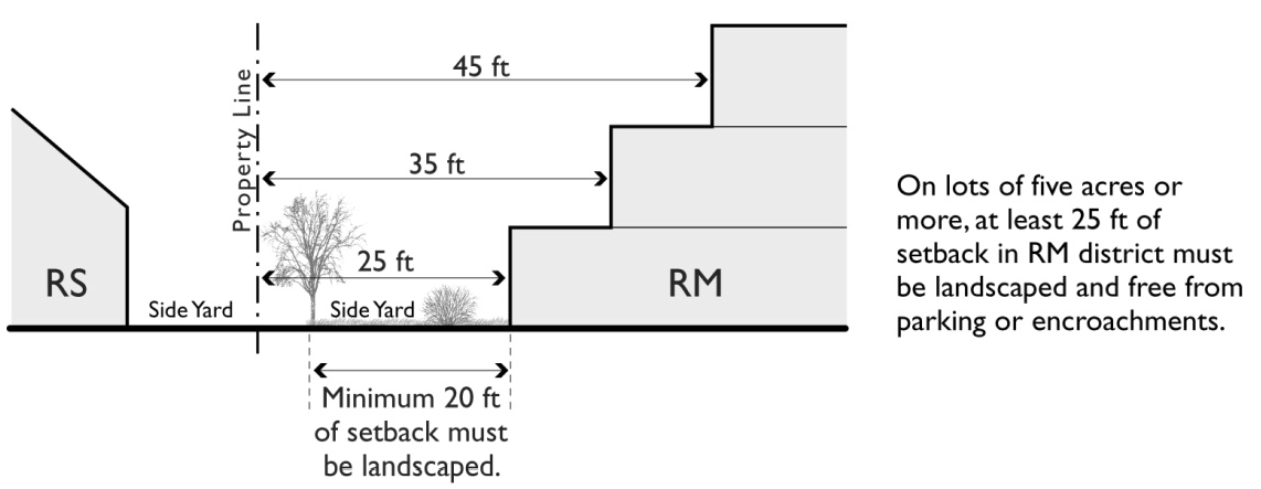
FIGURE 11-5-5.A(1): SETBACK ADJACENT TO RS DISTRICT
2.
Building Separation. Design Objective: Arrange buildings with residential units in a manner that addresses privacy issues for individual units and allows sufficient separation so that daylight and air is available for each residential unit. If building projections encroach into the required building separation space, ensure that remaining open space is attractive, useable and complies with CPTED design principals.
a.
Non-Parallel Buildings. For non-parallel buildings, the minimum building separation requirement shall be calculated by determining the open area that would be required between any two (2) buildings if they were parallel and met the minimum requirement; then assuring that the same or greater total open area is available between the two (2) buildings. At no time shall any points of the buildings be closer than ten (10) feet.
b.
Ground Floor Separation. Ground floor building separation distance may be reduced up to 20 percent if the upper floor steps back an equal distance. For example, if the required building separation between two (2), three (3) story buildings is 35 feet, the ground floor units may be separated by 28 feet provided the upper stories are stepped back so that the building separation for upper stories is no less than 42 feet.
c.
Maximum Encroachment. A maximum encroachment of three (3) feet is allowed for individual building projections, including but not limited to balconies, patios, bay windows, fireplaces, and stairs.
3.
Standards for Required Open Space. Provide residents with both private and public outdoor space that may be used for social, recreational, aesthetic, and economic purposes.
a.
Proportion of Private and Common Open Space. Open space may be provided in any combination of private and common open space, as long as studio and one (1) bedroom units have at least 60 square feet of private open space, two (2) bedroom units have at least 100 square feet of private open space and three (3) bedroom or more have at least 120 square feet of private open space.
b.
Surfacing. Surfaces provided for outdoor activities shall allow convenient use for outdoor activities. Such surface may be any combination of lawn, garden, brick, flagstone, wood planking, concrete, or other serviceable, dust-free surface.
c.
Slope. The slope of required open space areas shall not exceed ten percent (10%).
d.
Exclusive Dedication. Off-street parking and loading areas, driveways, and service areas shall not be counted as usable open space.
e.
Additional Standards for Private Open Space.
i.
Accessibility and Location. Private open space shall be accessible to only one (1) living unit by a doorway to a habitable room or hallway. Multiple spaces may be provided for individual living units to meet the aggregate open space requirement, provided at least one (1) private open space meets the minimum dimensions below:
(1)
Private open space located at the ground level (e.g., yards, decks, patios) shall have no dimension less than ten (10) feet.
(2)
Above-ground private open space (e.g., balconies) shall be a minimum of 60 square feet and shall not be less than eight (8) feet wide or less than six (6) feet deep.
ii.
Openness. Open space shall be at least 50 percent (50%) covered and shall have at least one (1) exterior side that is open and unobstructed between three (3) and eight (8) feet above its floor level.
f.
Additional Standards for Common Open Space.
i.
Accessibility. Common open space shall be easily accessible to all dwelling units that it is intended to serve and centrally located.
ii.
Location. Common open space shall be located within the same development as the units served. It may not be located within the required front or street-facing side setback. Up to 20 percent (20%) of common open space may be located on the roof of a building. In districts with a U-designator, up to 67 percent (67%) common open space may be on a roof.
iii.
Minimum Dimensions. Common open space shall have no dimension less than 15 feet.
iv.
Openness. Common open space shall be unroofed and unobstructed, except for facilities that enhance its usability, such as armadas or playground shade structures, and except that up to 25 percent (25%) of ground-level common open space may be covered by a balcony projecting from a higher story.
v.
Amenities. Common open space must be designed and provide sufficient amenities (e.g. seating, recreation facilities, armadas, shade, etc.) to encourage or invite one or more uses by the residents of the development.
B.
Site Planning and Design Standards.
1.
Character and Image.
a.
Monumentation. Provide enhanced entryway design where entry streets intersect arterials or major collectors. Such gateway features provide a sense of arrival through the use of monument signage, special landscaping, specialty pavement, enhanced wall details, architectural tower or arch features and/or water features.
b.
Identity and Amenity Features. Open space, recreational amenities, and community features shall be thoughtfully designed and sited as to create a sense of place and foster a sense of community.
c.
Architectural Variation. Where adjacent to existing multiple residence dwellings, unique massing and architectural design shall be provided to avoid the appearance of large contiguous developments.
2.
Massing and Scale.
a.
Architectural Articulation. Long facades shall be broken up into smaller modules. This requirement shall be met by using two (2) or more of the following methods:
i.
Façade Articulation. All street-facing facades have at least one (1) horizontal or vertical projection or recess of at least four (4) feet in depth, or two (2) projections or recesses of at least 2.5 feet in depth, for every 25 horizontal feet of wall. If located on a building with two (2) or more stories, the articulated elements must be greater than one (1) story in height and may be grouped rather than evenly spaced in 25-foot modules so long as the total amount of articulation meets or exceeds that which would be required if no grouping occurred. Building entrances and front porches and projections into required yards such as stoops, bays, overhangs, fireplaces, and trellises count towards this requirement.
ii.
Variable Roof Form. Variable roof forms are incorporated into the building design, and no more than two (2) side-by-side units may be covered by one (1) unarticulated roof. Articulations may be accomplished by changing roof height, offsets, and direction of slope, and by introducing elements such as dormers, towers, or parapets.
iii.
Façade Detailing and Materials. All visible building façades incorporate details, such as window trim, window recesses, cornices, changes in materials or other design elements, in an integrated composition. Each side of a building that is visible from a public right-of-way, parking lot, or common open space shall be designed with a complementary level of detailing and quality of materials.
iv.
Use of Balconies, Bay Windows, and Other Such Projections or Recesses. The building incorporates balconies, bay windows, entry porches or other projections and recesses in a pattern that creates architectural interest across approximately 30 percent (30%) of the length per floor of the façade or an alternative approved by the Planning Director. In approving such an alternative design, the Planning Director shall find the alternative to consist of a superior design that those required by the zoning ordinance.
v.
Encroachments. To facilitate the use of architectural features, building projections may extend into required yards, subject to the following standards:
(1)
Entry porches, balconies and patios may encroach no more than an additional ten (10) feet into required street side setbacks of 20 feet or greater in depth (measured from property line to building).
(2)
No projection may extend into a public utility easement or closer than two (2) feet to an interior lot line.
(3)
Awnings, eaves, overhangs, or basement window wells may encroach up to three (3) feet into any required yard.
(4)
Vestibules, bay windows, nooks, chimneys, or similar wall projections with or without footings may encroach not more than three (3) feet into any required front or rear yard and not more than two (2) feet into any required side yard, provided the aggregate width of all such projections adjacent to any yard does not exceed one-third (⅓) of the length of the building wall.
(5)
Staircases may encroach up to three (3) feet into any required front yard, and up to ten (10) feet into any required rear yard.
3.
Building Entrances.
a.
Dwelling Unit Access. Exterior entrances to units shall be in the form of individual or shared entrances at the ground floor of the building. Unit entrances located above the ground floor are also permitted; however, access corridor located above the ground floor are discouraged from providing access to more than four (4) units per floor.
b.
Orientation. All units located along public rights-of-way must have the primary entrance to the building, or individual unit entrances, facing this right-of-way. Exceptions to this requirement may be approved for projects where multiple-residence housing is located on four (4) or six (6) lane streets carrying high traffic volumes. In such cases, the project may be oriented around courtyards or civic spaces.
c.
Projection or Recess. Building entrances and individual exterior unit entrances must have a roofed projection (such as a porch) or recess with a minimum depth of at least five (5) feet and minimum horizontal area of 50 square feet. Alternative designs that create a welcoming entry feature facing the street, such as a trellis or landscaped courtyard entry, may be reviewed and approved through the Design Review process.
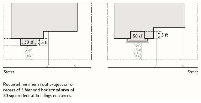
FIGURE 11-5-5.B(1): BUILDING
ENTRANCE PROJECTION OR RECESS
d.
Rental Office Location. The rental office location and orientation shall be accessible by a defined pedestrian path from the public street.
4.
Access, Circulation and Parking. The parking and circulation system within each development shall accommodate the movement of vehicles, bicycles, pedestrians and transit, throughout the proposed development and to and from surrounding areas, safely and conveniently, and shall contribute to the attractiveness of the development.
a.
Directness and Continuity. Walkways within the site shall be located and aligned to provide continuous connection between buildings, and various site amenities such as play areas, club houses, pools, mailboxes, etc. Walkways shall not be located and aligned solely based on the outline of a parking lot configuration that does not provide such direct pedestrian access.
b.
Off-Site Access. Pedestrian and bicycle circulation system must be designed to provide, or allow for, direct connections to trails, parks, schools, transit stops or other public amenities adjacent to the development. Drive aisles leading to main entrances shall have walkways on both sides of the drive aisle.
c.
Location of Parking Areas. Parking areas shall primarily be located to the side or rear of buildings with the exception of visitor parking, which may be located between a building and the adjacent street. The total frontage of parking areas visible from the street, including open parking, carports, and garages, but excluding underground parking and parking located behind buildings, shall not exceed 30 percent (30%) of the lot frontage.
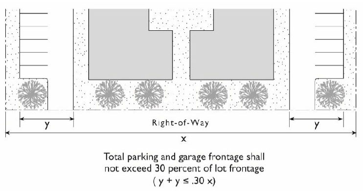
FIGURE 11-5-5.B(2): PARKING AND
GARAGE FRONTAGE LIMITATION
d.
Parking Area Scale. Large surface parking lots shall be visually and functionally segmented into several smaller lots providing residents with short and direct access to dwelling units. Parking lot clusters can be separated by elements such as, landscaping, pedestrian connections, building placement, cross aisles, and common open space.
e.
Guest Parking. Guest parking spaces shall be distributed proportionally to the dwelling unit locations that they are intended to serve.
f.
Attached Garages.
i.
In one (1) story buildings that include livable floor area, walls containing garage doors shall be set back a minimum of three (3) feet from the front façade of the building.
ii.
In multi-story buildings that include livable floor area, garage doors located below upper-story living space shall be recessed at least three (3) feet from the upper story facade.
iii.
When multiple garage doors are located within one (1) building, the maximum number of garage doors adjacent to one another shall be limited to three (3), unless there is a break in the building façade between garage doors. The break shall contain a major architectural feature, such as a building entrance or equivalent feature.
g.
Detached Garages. Perimeter garages that face public right-of-way or private property shall be designed to provide interest and avoid long blank walls through articulation in horizontal wall plane and roof line, detailing around doors, mix of materials, windows or other fenestration.
5.
Materials.
a.
Required primary exterior building materials shall be brick, stone, integrally tinted and textured masonry block, precast concrete, wood, natural and synthetic stone, stucco and synthetic stucco, and glazing. A minimum of seventy-five percent (75%) of all exterior building walls shall be covered with required primary building materials or other materials approved by the Planning Director or designee. Metal shall not be used as a primary exterior building material.
b.
Buildings must contain at least two (2) kinds of primary exterior materials distinctively different in texture or masonry pattern, with each of the required materials covering at least twenty-five percent (25%) of the exterior walls of the building.
c.
Architectural metals, such as bronze, brass, copper and wrought iron, may be used on the primary facade of any building but may not exceed twenty-five percent (25%) of the area of the primary facade. Other materials may be evaluated for use as primary or accent materials by the Planning Director or designee to determine whether the proposed materials are equal or superior to the required primary building materials and permissible for use.
6.
Alternative Compliance. Site Planning and Design Standards are not intended to limit creative solutions. Conditions may exist where strict compliance to Site Planning and Design Standards of this Chapter are impractical or impossible, or where maximum achievement can only be obtained through alternative compliance. Alternative compliance does not modify or reduce requirements of the Building Code or any other chapters or sections of the Zoning Code. Alternative compliance allows development to satisfy the Site Planning and Design Standards in this chapter by providing comparable standards in a creative way.
a.
Requests for alternative compliance may be accepted for any application to which Site Planning and Design Standards apply. A written request must be provided in conjunction with the applicable land use application describing how the proposed alternative meets the criteria below.
b.
The approving body shall find that the request meets one (1) or more of the following criteria:
i.
Topography, soil, vegetation or other site conditions are such that full compliance is impossible or impractical; or improved environmental quality would result from alternative compliance.
ii.
Space limitations, unusually shaped lots and prevailing practices in the surrounding neighborhood, may justify alternative compliance for bypassed parcels and for improvements and redevelopment in older neighborhoods.
iii.
Safety considerations make alternative compliance necessary.
iv.
The proposed alternative is aesthetically more complementary to the site, better fits into the context of the area, improves the overall architectural appeal of the area and/or meets or exceeds the urban design characteristics as described in the City's General Plan.
(Ord. No. 5541, § 2, 12-9-19; Ord. No. 5593, § 5, 12-1-20; Res. No. 12269, § 3, 9-23-24; Ord. No. 5883, § 3, 10-7-24; Ord. No. 5928, §§ 1, 2, 2-3-25)
11-5-6: - ADDITIONAL STANDARDS FOR RM DISTRICTS WITH URBAN COMMUNITY CHARACTER DESIGNATOR (-U)
The regulations of this section apply to the RM-3U, RM-4U, and RM-5 districts in order to support pedestrian-oriented development. Design Objective: Create an attractive, comfortable, safe urban environment defined by building fronts, streets and the community space in between.
A.
Building Entrance. Design Objective: The main access into the development should be readily visible from the street and engage the street to help create an active street life.
The main entry into a multiple residence building shall be designed with a direct connection with the adjacent public street either by being immediately adjacent to the street or through a courtyard that directly connects to the street. The entry into individual units not in a multi-residence structure shall be through small individual courtyards, or by the first floor of the structure being raised a half story above street level.
B.
Location of Parking Areas. Design Objective: Minimize the distance from the entrance features to the street and provide convenient access for alternative transportation modes.
Parking areas shall only be located to the side or rear of buildings and shall not be located between a building and the adjacent street. On corner lots, the requirements of this subsection apply to the frontage on the street with the highest functional classification. If a site fronts two (2) public streets of equal classification identified in the Mesa Transportation Plan, the applicant shall meet the requirement on both streets.
C.
Maximum Building Setbacks. Design Objective: To align buildings in a predictable manner that creates a street wall, minimizes the walking distance to the building from the street, and yet provides opportunities for environmentally comfortable public interactive spaces, such as plazas and courtyards, to be designed and placed between the building and the right-of-way in a manner considered to be traditional for urban contexts.
The street-facing facades of buildings must be located no farther from street-facing property lines than the maximum setback distance specified in Table 11-5-5. The following additional provisions apply:
1.
Corner Properties. Where a property fronts on two (2) or more streets, the building shall be placed no farther than the maximum setback on two (2) sides for at least 30 feet on each side. This standard shall be met along the frontage of the streets with the highest functional classification identified in the Mesa Transportation Plan. If streets adjacent to the property have the same functional classification, the developer shall choose which frontages for which the standard applies.
2.
Sites with More than One Building. Where multiple buildings are placed on one (1) site, the ground level of a building or buildings shall be placed no further back than the maximum setback for a minimum of 65 percent (65%) of the width of the lot.
3.
Building Additions. For any addition to a building that increases the width of a street-facing façade, 100 percent (100%) of the addition must be located on or within the maximum setback until the requirement of C.2, above, is met for the entire building.
4.
Exceptions to Maximum Setback Requirements. The following exceptions to the maximum setback requirement are permitted:
a.
Articulated Building Street Face. Where a portion of the building is placed back from the maximum setback to provide an entry or other feature creating variation in the facade, the total area of the space created by the setback must be less than the area of one (1) square foot per linear foot of building frontage.
b.
Outdoor Eating Areas. Where an outdoor eating area will be installed on the street frontage, that portion of the building adjacent to the eating area may be set back up to 12 feet farther than the maximum setback line, if at least 40 percent (40%) of the building facade is no farther than the maximum setback.
c.
Residential Uses. For buildings or portions of buildings that are in residential use, open porches located at or within the maximum setback shall count toward meeting the build-to requirement if such porches are at least ten (10) feet wide and six (6) feet deep.
D.
Fences, Walls, and Screening. Design Objective: When using the -U designator, the goal is to create lively, pedestrian oriented, mixed-use environments. Therefore, fences, walls, and screening should only be used when required to provide a separation from a less intense use or to screen service areas or parking.
Fences, walls, and screening as required by this Ordinance shall be provided to screen service areas, trash receptacles, and similar uses. Fences and walls may be required to provide a separation from less intense uses, but shall be discouraged in other situations.
(Ord. No. 5541, § 2, 12-9-19; Ord. No. 5928, §§ 3, 4, 2-3-25)
11-5-8: - COMPREHENSIVE YOUTH RESIDENCE
A.
Comprehensive youth residences are allowed in the RS-90 District upon approval of a Special Use Permit, provided all of the following items are present:
1.
The site contains at least 20 contiguous acres; and
2.
The facility is licensed by the State of Arizona; and
3.
The number of beds provided by the facility exceeds 25; and
4.
The facility provides on-site counseling, education and recreation catering specifically to the resident population; and
5.
All applicable setbacks and building height requirements for the R1-90 District are maintained.
B.
In addition to the mandatory items listed above, such facilities may include, but are not required to have, such uses as on-site retail stores, offices, indoor or outdoor recreation (including equestrian) facilities, and detached staff residences, all of which directly relate both to the support and to the operation of the facility, and are clearly considered as an accessory use to the primary activity. If provided, accessory retail and accessory office uses, in aggregate for both uses, shall not exceed 10 percent (10%) of the aggregate gross floor area as shown on an approved Comprehensive Site Plan of the entire facility. On-site detached staff residences may consist of manufactured housing.
C.
Spaces with utility connections may be provided for Recreational Vehicles (RVs) for use by temporary or seasonal volunteers as temporary quarters, provided:
1.
No park model RV units are used,
2.
No space is used for longer than six (6) months out of a 12-month calendar year by an individual or family, and
3.
No RV accessory structures, as defined in Chapter 87, are constructed.
(Ord. No. 5541, § 2, 12-9-19)
11-5-9: - REVIEW OF PLANS
Permit and review procedures shall follow the standards established in Article 7, Administration.
(Ord. No. 5541, § 2, 12-9-19)
11-6-1: - PURPOSE
A.
General Purposes of Commercial and Mixed-Use Districts. The purposes of the commercial and mixed-use districts are to:
1.
Provide for the orderly, well-planned, and balanced growth of commercial areas.
2.
Plan for and allow office and commercial development to expand the variety of goods and services to meet the needs of Mesa residents and those living within Mesa's market area.
3.
Allow mixed-use commercial/residential development, where consistent with the General Plan, to promote less reliance on automobiles for mobility and result in a reduction in vehicle miles traveled.
4.
Establish development standards that improve the visual quality of commercial and mixed-use development and create a unified, distinctive, and attractive character along commercial streets.
5.
Contribute to the pedestrian environment with standards that promote ground-floor visibility, orientation of buildings to the street, shaded connectivity, opportunities for community interaction, and pedestrian access across parking lots and between commercial centers and adjacent land uses.
6.
Integrate new development into existing or planned context, as appropriate, address transitions, and provide appropriate buffers between commercial and residential uses.
7.
Encourage improvements, such as architectural features and landscaping to mitigate air and storm water pollution and reduce the effects of the urban heat island.
8.
Encourage commercial and mixed-use developments to include improvements, such as landscaping, to mitigate air and storm water pollution, to provide shade to reduce the effects of the urban heat island, and to consider solar orientation to take full advantage of sun angles and reduce potential energy consumption.
B.
Specific Purposes of Each District.
1.
NC Neighborhood Commercial. To provide areas for locally oriented retail and service uses that serve the surrounding residential trade area within a ½ to two (2) mile radius. Typical uses include, but are not limited to retail stores, grocery-store-anchored shopping centers, drug stores, restaurants and cafes, gas stations, and convenience stores. Other compatible uses include small-scale medical and professional offices, personal services, as well as public and semi-public uses. Large commercial development buildings are not appropriate in the Neighborhood Commercial District.
2.
LC Limited Commercial. To provide areas for indoor retail, entertainment and service-oriented businesses that serve the surrounding residential trade area within a one (1) to ten-mile radius. Typical uses include, but are not limited to, grocery store and additional large commercial developments, anchored tenant shopping centers with additional drug stores, fast-food restaurants, hardware and building supply stores, gas stations with convenience stores, and restaurants and cafes. Other typical uses include, but are not limited to, those anchors and large commercial developments that are typically located within a regional mall, retail outlet, or power center. Other compatible uses include medical and professional offices, as well as public and semi-public uses.
3.
GC General Commercial. To provide indoor retail, limited outdoor display and related service-oriented businesses that serve a large surrounding residential trade area within a 4- to 5-mile radius. This district includes several automobile-oriented uses and similar support services related to automobiles, welding, and light assembly and fabrication related to an on-site commercial use. Other supportive uses may include, but are not limited to commercial lodging, automotive, restaurant, and movie uses, as well as office uses and public- and semi-public uses.
4.
OC Office Commercial. To provide areas for small-scale medical and professional offices intended to serve the community and remain compatible with adjacent residential areas.
5.
MX Mixed Use. To provide areas for a variety of purposes including employment centers, retail and service commercial uses, medical and professional offices, and residential uses at densities of 15 to 25 units per acre. Residential densities in excess of 25 dwelling units per acre may be appropriate in selected locations.
(Ord. No. 5541, § 2, 12-9-19; Ord. No. 5928, § 5, 2-3-25)
11-6-2: - LAND USE REGULATIONS
In Table 11-6-2, which follows, the land use regulations for each Commercial and Mixed-Use zoning district are established by letter designations as follows:
• "P" designates use classifications permitted in commercial districts.
• "SUP" designates use classifications permitted on approval of a Special Use Permit.
• "CUP" designates use classifications permitted on approval of a Council Use Permit.
• "TUP" designates use classifications permitted on approval of a Temporary Use Permit.
• "(x)" a number in parentheses refers to limitation following the table.
• "—" designates a prohibited use.
All activities shall be conducted entirely within an enclosed building with no outside storage or display, unless otherwise specified. Use classifications not listed are prohibited. The "Additional Use Regulations" column includes specific limitations applicable to the use classification or refers to regulations located elsewhere in this Ordinance.
(Ord. No. 5541, § 2, 12-9-19; Ord. No. 5592, § 3, 12-1-20; Ord. No. 5593, § 6, 12-1-20; Ord. No. 5632, § 1, 7-8-21; Ord. No. 5758, § 1, 12-8-22; Ord. No. 5759, § 1, 12-8-22; Ord. No. 5813, § 1(Exh. 1), 10-16-23; Ord. No. 5814, § 1(Exh. 1), 10-16-23; Ord. No. 5858, § 2, 7-1-24; Res. No. 12269, § 4, 9-23-24; Ord. No. 5883, § 3, 10-7-24; Ord. No. 5904, § 1, 12-9-24; Ord. No. 5957, § 1, 7-8-25; Ord. No. 5976, § 3, 1-12-26)
11-6-3: - DEVELOPMENT STANDARDS
A.
Zoning District Standards. Table 11-6-3(A) prescribes the development standards for the commercial districts without the additional character designators. Table 11-6-3(B) prescribes the development standards for the commercial and mixed-use districts with the character designators. The "Additional Standards" column lists additional standards that apply in some or all commercial districts. Section numbers in this column refer to other sections of the Zoning Ordinance, while individual letters refer to subsections that directly follow the table.
B.
Site Planning and Design Standards.
1.
Character and Image. Development shall contribute to the uniqueness of the zone district in which it is located, and/or the Mesa community with predominant materials, elements, features, color range, and activity areas tailored specifically to the site and its context. This character and image shall conform to the following standards:
a.
Group Commercial. In multiple building developments, each individual building shall include predominant characteristics shared by each building so that the buildings within the development appear to be part of a cohesive, planned area, yet are not monotonous in design. Compatibility shall be achieved through techniques such as, the replication of roof lines, the use of similar proportions in building mass and outdoor spaces, similar relationships to the street, similar window and door patterns, or the use of building materials that have color shades and textures that are similar to or complimentary to those existing on, or in the immediate area of, the subject property.
i.
Developments located within a planning sub-area, such as Desert Uplands, Mesa Gateway, Citrus Sub-Area, Downtown, or any other designated sub-area, shall be consistent with any City design policy adopted for such sub-area.
b.
No Established Theme or Stand-alone Development. Where there is no established or consistent neighborhood or area character or unifying theme, or where the existing character is not desirable to continue, because it does not reflect a design theme consistent with the development standards as described in this Chapter, the proposed development shall be designed to establish character and a sense of place through the strategic use of architectural elements, building form, materials, landscaping, lighting, etc. which creates a cohesive theme or style for future developments and buildings within the area to follow.
c.
Corporate Architecture. Where the proposed architecture of a building or structure is the result of a franchise style, prototypical or franchise architectural design, including materials and color, shall be modified if necessary to meet these development standards and set a standard, or contribute to a high-level of quality for future developments and buildings within the area.
d.
Large Commercial Development. Each large commercial development (over 25,000 square feet or commercial centers with four (4) or more buildings whose combined gross floor area exceeds 25,000 square feet shall contribute to the establishment or enhancement of the community and public spaces.
i.
Open Space. Public space shall be provided at a rate of five (5) square feet per 1,000 square feet of building floor area but shall not exceed 15,000 square feet of open space. Required sidewalks shall not be included in the open space calculation.
ii.
Location. Such public space shall be visible from a public street, or from on-site areas normally frequented by customers, and shall be accessible during business hours. Areas within required setbacks may count toward the public space requirement. Areas designated for customers to wait for rideshare services may be combined with required public space.
iii.
Amenities. On-site public space shall include amenities and a ground surface that is landscaped or surfaced with distinguishable and durable paving materials. Amenities shall enhance the comfort, aesthetics, or usability of the space, and may consist of but are not limited to, patio/seating areas, pedestrian plazas with benches, transportation centers, paseos, outdoor playground areas, kiosk areas, water features, amphitheaters, clock towers or other such deliberately shaped area and/or a focal feature or amenity.
e.
Pad Developments. Freestanding pad development site design shall be complementary to the surrounding center in terms of building scale, materials, colors, and other architectural details.
2.
Massing and Scale. The design of buildings shall avoid the appearance of a single, large, dominant building mass by using design techniques that include stepping back portions of the building facade, breaking up the mass into smaller elements and/or using material changes.
a.
Wall Articulation. Exterior building walls shall be subdivided and proportioned to human scale, using projections, overhangs and recesses in order to add architectural interest and variety and to avoid the effect of a single, massive wall with no relation to human size.
i.
Publicly visible facades (viewed from rights-of-way or private property), may not have blank, uninterrupted wall lengths exceeding 50 feet without including at least two (2) of the following: change in plane, change in texture or masonry pattern, windows, trellis with vines, or an equivalent element that subdivides the wall into human scale proportions.
ii.
Side or rear walls, not publicly visible from rights-of-way or private property, may include false windows and door openings when actual doors and windows are not feasible because of the of the use of the building. Such fenestration, (false windows and door openings) shall be defined by frames, sills and lintels, or similarly proportioned modulations of the wall.
iii.
Encroachments. Awnings, eaves, overhangs, and light shelves may encroach up to three (3) feet into any required yard but shall not be closer than two (2) feet to any property line. Exception, the zoning administrator may approve minor building projections that extend into the required setback upon finding that the encroachment responds to functional requirements of the project, does not adversely affect the adjacent property, and complies with all requirements of the building code.
b.
Roof Articulation. Provide architectural interest at the skyline and accentuate appropriate building elements.
i.
Vary building height, providing at least two (2) changes in height or roof forms that are varied over different portions of the building through changes in pitch, plane, and orientation.
ii.
Flat roofs or facades with a horizontal eave, fascia, or parapet, in excess of one hundred feet in length, must provide vertical modulation. The minimum vertical modulation is two (2) feet or one-tenth ( 1/10 ) multiplied by the wall height, not to exceed one-third (⅓) of the height of the supporting wall.
iii.
All parapets must have detailing such as cornices, moldings, trim, or variations in brick coursing.
iv.
Multi-building developments shall be configured to locate the tallest and largest structures within the core of the site and provide a gradual decrease in building height and mass towards adjacent residential land uses.
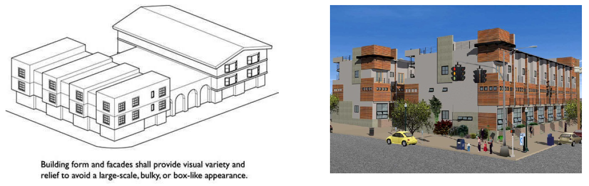
FIGURE 11-6-3.B(1): MASSING & SCALE
3.
Building Entrances. Primary public building entrances shall be clearly defined, shaded, and inviting. The architectural details of building entrances shall be integrated with the overall building design in terms of materials, scale, proportion, and design elements and are appropriately scaled for people.
a.
Entries shall be recessed, projected or framed by elements such as awnings, arcades or porticos.
b.
Orientation. Primary entries shall face the street or primary pedestrian areas.
4.
Access, Circulation, and Parking. The parking and circulation system within each development shall accommodate the movement of vehicles, bicycles, pedestrians and transit, throughout the proposed development and to and from surrounding areas, safely and conveniently, and shall contribute to the attractiveness of the development.
a.
Pedestrian Facilities and Amenities. Pedestrian facilities shall integrate landscaping, shading, lighting, surface treatment, and other amenities to create an attractive, quality environment.
i.
Pedestrian Walkways. A continuous system of hard-surfaced, safe, and convenient pedestrian walkways at least five (5) feet wide shall be provided pedestrian walkways shall connect on-site buildings to one another, to automobile and bicycle parking areas, to any on-site open space areas or pedestrian amenities, and to the adjacent public right-of-way. A minimum of 50 percent (50%) of pedestrian walkways shall be shaded either by structures or with landscaping.
ii.
Safety Considerations. Where pedestrian walkways cross-vehicular traffic aisles and driveways, potential hazards shall be minimized by the use of techniques such as special paving, raised surfaces, pavement marking, signs or striping, bollards, median refuge areas, traffic calming features, landscaping, lighting or other means to clearly delineate pedestrian areas, for both day and night use.
b.
Bicycle Parking. Adequate, safe, and convenient bicycle parking facilities shall be provided short-term bicycle parking spaces for the use of customers and visitors shall be located close to building entrances, easily identifiable, visible to those passing by, and separate from pedestrian circulation areas. Long-term bicycle parking for the use of employees, such as bicycle lockers, designated areas within buildings, or outside areas with visual monitoring is strongly encouraged.
c.
Transit Facilities. When transit facilities are located directly adjacent to development; the development shall provide efficient and comfortable pedestrian routes to the transit facilities. Pedestrian routes shall include design features such as, shading structures, seating, landscaping, decorative paving, or public art features.
d.
Parking spaces shall be located behind buildings. If there are physical attributes of the property that prevents the parking spaces from being located behind the buildings, the property owner may seek alternative compliance.
e.
Large Commercial Development. Large commercial development shall:
i.
Provide one (1) major driveway entrance feature such as a landscaped entry corridor, landscape median, round-about, or similar entryway feature that provides an organizing element to the site design.
ii.
Entry Plazas/Passenger Loading Areas. A plaza shall be provided at the entry to each anchor tenant building, that provides for pedestrian circulation and vehicle passenger loading and unloading. Entry plazas and passenger loading areas shall provide decorative paving materials, adequate seating areas, adequate shade, and attractive landscaping including trees and/or raised planters.
iii.
No more than fifty percent (50%) of required parking spaces shall be located between the front facade and the abutting street (the "front parking area"). The front parking area shall be determined by drawing a line from the front corners of the building to the nearest property corners. Supermarkets are exempt from this requirement.
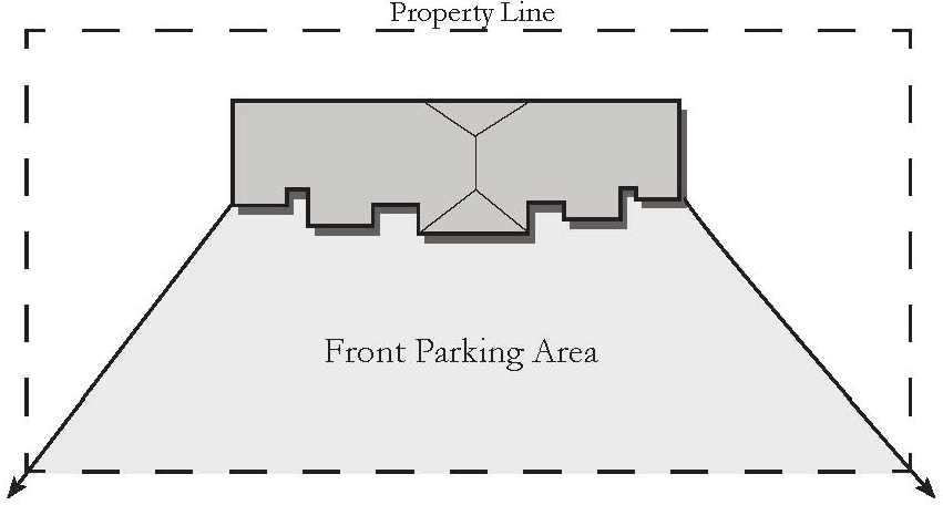
FIGURE 11-6-3.B(2): FRONT PARKING AREA
5.
Materials and Colors. Buildings and structures shall be constructed of durable, high-quality materials appropriate for Mesa's climate such as, brick, stone, integrally tinted and textured masonry block, precast concrete, wood, natural and synthetic stone, stucco and synthetic stucco, and glazing.
a.
Pre-engineered metal buildings are not allowed in the commercial and mixed-use districts.
b.
All visible pitched roofs shall consist of metal seam, clay tile, concrete tile, or a similar grade of roofing material.
c.
To reduce the apparent massing and scale of buildings, facades shall incorporate at least three (3) different and distinct materials.
d.
No more than fifty percent (50%) of the total facade may be covered with one (1) single material.
e.
Buildings larger than 10,000 square feet shall be finished with more than one (1) color on all elevations that are visible from the street.
f.
Predominant facades colors shall be low reflectance, subtle, neutral or earth tone colors. The use of high-intensity colors as the predominant building color, such as black or fluorescent colors, are prohibited. Building trim and accent areas may feature brighter colors. Accent colors shall cover no more than five percent (5%) of street-facing facades.
g.
Base and Top Treatments. All facades shall have:
i.
A recognizable "base" consisting of (but not limited to):
(1)
Thicker walls, ledges or sills;
(2)
Integrally textured materials such as stone or other masonry;
(3)
Integrally colored and patterned materials such as smooth finished stone or tile; or
(4)
Lighter or darker colored materials, mullions or panels; or planters.
ii.
A recognizable "top" consisting of (but not limited to):
(1)
Cornice treatments, other than just colored "stripes" or "bands," with integrally textured materials such as stone or other masonry or differently colored materials;
(2)
Sloping roof with overhangs and brackets; or
(3)
Stepped parapets.
h.
All Side Architecture. Architectural detailing on facades may vary depending on visibility and orientation; however, all publicly visible facades shall provide equivalent architectural detailing commensurate with the main façade.
6.
Loading and Service Areas. Loading and service areas must be located on the side or the rear of buildings and away from public view. Loading and servicing area may not face public streets.
7.
Alternative Compliance. Site Planning and Design Standards are not intended to limit creative solutions. Conditions may exist where strict compliance to Site Planning and Design Standards of this Chapter are impractical or impossible, or where maximum achievement can only be obtained through alternative compliance. Alternative compliance does not modify or reduce requirements of the Building Code or any other chapters or sections of the Zoning Code. Alternative compliance allows development to satisfy the Site Planning and Design Standards in this Chapter by providing comparable standards in a creative way.
a.
Requests for alternative compliance may be accepted for any application to which Site Planning and Design Standards apply. A written request must be provided in conjunction with the applicable land use application describing how the proposed alternative meets the criteria below.
b.
The approving body shall find that the request meets one (1) or more of the following criteria:
i.
Topography, soil, vegetation or other site conditions are such that full compliance is impossible or impractical; or improved environmental quality would result from alternative compliance.
ii.
Space limitations, unusually shaped lots and prevailing practices in the surrounding neighborhood, may justify alternative compliance for bypassed parcels and for improvements and redevelopment in older neighborhoods.
iii.
Safety considerations make alternative compliance necessary.
iv.
The proposed alternative is aesthetically more complementary to the site, better fits into the context of the area, improves the overall architectural appeal of the area and/or meets or exceeds the urban design characteristics as described in the City's General Plan.
(Ord. No. 5541, § 2, 12-9-19; Ord. No. 5593, § 7, 12-1-20; Ord. No. 5928, §§ 7, 8, 2-3-25)
11-6-4: - SPECIAL STANDARDS FOR DISTRICTS WITH -U COMMUNITY CHARACTER DESIGNATOR
The regulations of this section apply to the NC-U, LC-U, OC-U, and MX-U Districts in order to support pedestrian-oriented development. Design Objective: Create an attractive, comfortable, safe urban environment defined by building fronts, streets and the community space in between.
A.
Building Main Entry Orientation. Design Objective: Focus activity on the urban streets and walkways by providing direct connections from sidewalks to building entrances.
The primary entrance(s) of a building shall face or be oriented to within 45 degrees of parallel to the street frontage. This entrance(s) must allow pedestrians to both enter and exit the building. Where a site is located on two public streets, a primary entrance shall be oriented toward the street with the higher functional classification identified in the Mesa Transportation Plan. If a site fronts two public streets of equal classification, the applicant may choose which frontage on which to meet the requirement.
B.
Ground-Floor Transparency. Design Objective: Create vibrant, safe environments along urban streets and walkways.
Exterior walls facing any front or street-facing lot line shall include windows, doors, or other openings for at least 50 percent (50%) of the building wall area located between 2.5 and seven feet above the elevation of the sidewalk. No wall may run in a continuous plane for more than 20 feet without an opening. Openings fulfilling this requirement shall have transparent glazing and provide views into work areas, display areas, sales areas, lobbies, or similar active spaces, or into window displays that are at least three (3) feet deep.
1.
Exception for Structured Parking Facilities. Multi-level parking garages, where permitted, must meet the standards of Chapter 32, On-site Parking, Loading, and Circulation.
2.
Sites with Multiple Buildings. On sites that contain multiple buildings, the building ground-floor transparency requirement does not need to be met along street-facing facades of buildings if the façade is located behind other buildings and not visible from the adjacent public street.
3.
Reduction through Site Plan Review. The building transparency requirement may be reduced or waived, if it is found that:
a.
The proposed use has unique operational characteristics with which providing the required windows and openings is incompatible, such as in the case of a cinema or theater; and
b.
Street-facing building walls shall exhibit architectural relief and detail, or the building shall be enhanced with landscaping in such a way as to create visual interest at the pedestrian level and soften or mitigate the scale of the building form. Architectural relief and detail may be provided by exhibiting variety in the color, building massing, wall plane, and materials used. Building detailing shall be consistent with the proportions, rhythm, style and form of architecture presented.
C.
Location of Parking Areas.
1.
NC-U, LC-U, OC-U. Parking shall be located to the rear or side of buildings and shall not be located between a building and adjacent street. This requirement does not apply to structured parking garages.
2.
MX-U. Parking spaces shall be located to the rear or side of buildings, or between two (2) or more buildings on a lot. No parking space shall be located between a building and adjacent street. Any parking space located to the side of a building must meet the screening standard of Section 11-30-9(H), Parking Areas.
3.
Corner Lots. On corner lots, the requirements of this subsection apply to the street front with the highest functional classification identified in the Mesa Transportation Plan. If a site fronts two (2) public streets of equal classification, the applicant shall meet the requirement on both streets.
D.
Maximum Building Setbacks. The street-facing facades of buildings must be located no farther from street-facing property lines than the maximum setback distance specified in Table 11-6-3. The following additional provisions apply:
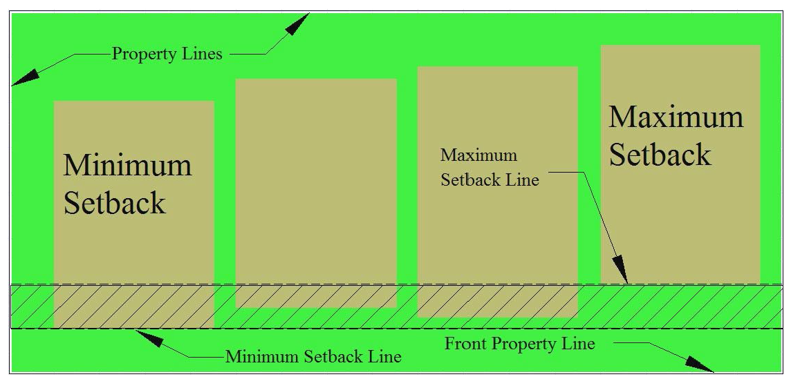
FIGURE 11-6-4.D(1): MAXIMUM BUILDING SETBACKS
1.
Corner Properties. Where a property fronts on two (2) or more streets, the building shall be placed at the maximum setback, or closer to the street right-of-way, on two (2) sides for at least 30 feet on each side. This standard shall be met along the frontage of the two (2) streets with the highest functional classification identified in the Mesa Transportation Plan. If all streets adjacent to the property have the same functional classification, the developer shall choose which frontages with which to meet the standard.
2.
Sites with More than One Building. Where multiple buildings are placed on one (1) site, the ground level of a building or buildings shall be placed no further back than the maximum setback for a minimum of 65 percent (65%) of the width of the lot.
3.
Building Additions. For any addition to a building that increases the width of a street-facing façade, 100 percent (100%) of the addition must be located on or within the maximum setback until the requirement of (D)2, above, is met for the entire building.
4.
Retention Basins. Retention basins shall be designed as an integral part of the site design theme and should be a usable element of the project, capable of serving multiple purposes.
5.
Exceptions to Maximum Setback Requirements. The following exceptions to the maximum setback requirement are permitted:
a.
Articulated Building Street Face. Where a portion of the building is placed back from the maximum setback to provide an entry or other feature creating variation in the facade, the total area of the space created by the setback must be less than the area of one (1) square foot per linear foot of building frontage.
b.
Outdoor Eating Areas and Plazas. Where an outdoor eating area or plaza will be installed on the street frontage, a portion of the building may be set back up to 12 feet farther than the maximum setback line, if at least 40 percent (40%) of the building facade is no farther than the maximum setback.
c.
Residential Uses. For buildings or portions of buildings that are in residential use, open porches or stoops located at or within the maximum setback shall count toward meeting the build-to requirement if such porches are at least ten (10) feet wide and six (6) feet deep.
(Ord. No. 5541, § 2, 12-9-19; Ord. No. 5928, §§ 9—11, 2-3-25)
11-6-6: - REVIEW OF PLANS
Permit and review procedures shall follow the standards established in Article 7, Administration.
(Ord. No. 5541, § 2, 12-9-19)
11-7-1: - PURPOSE
A.
General Purpose of Employment Districts. The purposes of the employment districts are to:
1.
Designate land for industrial, office, and research and development uses to provide a range of employment opportunities in Mesa.
2.
Provide for the appropriate location of businesses that may have the potential to generate off-site impacts, while providing compatibility in use and form.
3.
Provide appropriate buffers between employment and residential uses to preserve both employment feasibility and residential quality.
4.
Provide diverse options for types of employment-oriented areas, ranging from landscaped sites in campus-like settings, to mixed-use commercial and industrial areas, to industrial-only areas, to sites that are still well designed, but convey a minimalist or utilitarian approach, the entire range of which may contribute to providing the appropriate context for a successful business environment.
B.
Specific Purposes of Each District.
1.
PEP Planned Employment Park. To provide areas where professional and medical office parks, research and development facilities, light manufacturing, and data and information processing centers are integrated in a campus setting with ancillary restaurants, retail and other supportive establishments.
2.
LI Light Industrial. To provide areas for limited manufacturing and processing, wholesaling, research, warehousing, and distribution activities take place within enclosed buildings, with restricted accessory outdoor storage as needed to support the primary uses. Light Industrial areas can be used to buffer General Industrial uses from other less intense uses. This district also provides for a full range of commercial activities, generally on a limited scale, including high-impact commercial uses, outdoor display and outdoor sale. Individual developments include well-designed buildings on sites that may or may not have campus-like settings, and areas visible to the general public include well-designed landscape areas.
3.
GI General Industrial. To provide areas for manufacturing, processing, assembly, research, wholesale, and storage, and similar activities that require separation from residential uses due to noise, vibration, use of hazardous materials, or other characteristics. These activities principally take place indoors, but may also include some outdoor activities. This district also permits a full range of commercial activities.
4.
HI Heavy Industrial. To provide areas that are set aside principally for manufacturing, assembly, wholesaling, distribution and storage activities, with limited amounts of moderately scaled commercial activities provided only to the extent necessary to support industrial related activities. HI activities may take place indoors or outdoors. Land uses in this district include those activities that may adversely affect surrounding uses because of the after effects of the manufacturing, assembly and/or production process.
(Ord. No. 5541, § 2, 12-9-19)
11-7-2: - LAND USE REGULATIONS
In Table 11-7-2, which follows, the land use regulations for each Employment Zoning District are established by letter designations as follows:
• "P" designates use classifications permitted.
• "TUP" designates use classifications permitted on approval of a Temporary Use Permit.
• "SUP" designates use classifications permitted on approval of a Special Use Permit.
• "CUP" designates use classifications permitted on approval of a Council Use Permit.
• "(x)" a number in parentheses refers to limitation following the table.
• "SE" designates use classifications that are not allowed by right but are permitted if approved through a particular review procedure.
• "—" designates a prohibited use.
Use classifications not listed are prohibited. The "Additional Use Regulations" column includes specific limitations applicable to the use classification or refers to regulations located elsewhere in this Ordinance.
(Ord. No. 5541, § 2, 12-9-19; Ord. No. 5593, § 8, 12-1-20; Ord. No. 5633, § 2, 7-8-21; Ord. No. 5758, § 1, 12-8-22; Ord. No. 5759, § 1, 12-8-22; Ord. No. 5813, § 1(Exh. 1), 10-16-23; Ord. No. 5814, § 1(Exh. 1), 10-16-23; Ord. No. 5861, § 1, 7-8-24; Res. No. 12269, § 5, 9-23-24; Ord. No. 5833, § 3, 11-7-24; Ord. No. 5904, § 2, 12-9-24; Ord. No. 5957, § 2, 7-8-25; Ord. No. 5976, § 3, 1-12-26)
11-7-3: - DEVELOPMENT STANDARDS
A.
Zoning District Standards. Table 11-7-3 prescribes the development standards for the employment districts. The "Additional Standards" column lists additional standards that apply in some or all employment districts. Section numbers in this column refer to other sections of the Zoning Ordinance, while individual letters refer to subsections that directly follow the table.
B.
Site Planning and Design Standards.
1.
Character and Image. Development shall contribute to the uniqueness of the zone district in which it is located, and/or the Mesa community with predominant materials, elements, features, color range, and activity areas tailored specifically to the site and its context. This character and image shall conform to the following standards:
a.
In multiple building developments, each individual building shall include predominant characteristics shared by each building so that the buildings within the development appear to be part of a cohesive, planned area, yet are not monotonous in design. Compatibility shall be achieved through techniques such as, the replication of roof lines, the use of similar proportions in building mass and outdoor spaces, similar relationships to the street, similar window and door patterns, or the use of building materials that have color shades and textures that are similar to or complimentary to those existing on, or in the immediate area of, the subject property.
i.
Developments located within a planning sub-area, such as Desert Uplands, Mesa Gateway, Citrus Sub-area, Downtown, or any other designated sub-area, shall be consistent with any city design policy adopted for such sub-area.
b.
No Established Theme or Stand-alone Development. Where there is no established or consistent neighborhood or area character or unifying theme, or where the existing character is not desirable to continue, because it does not reflect a design theme consistent with the development standards as described in this Chapter, the proposed development shall be designed to establish character and a sense of place through the strategic use of architectural elements, building form, materials, landscaping, lighting etc. which creates a cohesive theme or style for future developments and buildings within the area to follow.
c.
Corporate Architecture. Where the proposed architecture of a building or structure is the result of a franchise style, prototypical or franchise architectural design, including materials and color, shall be modified if necessary to meet these development standards and set a standard, or contribute to a high-level of quality for future developments and buildings within the area.
d.
Employee and Visitor Amenities. Development within the Employment District shall provide common open space and amenities for the useful enjoyment of employees and visitors to the site. Common open space should be arranged for functionality and shall be furnished with eating areas, site furniture (such as benches, tables, waste receptacles, planters) or other amenities.
i.
Buildings 30,000 square feet or larger, shall be provided common open space at a rate of one percent (1%) per building gross floor area (GFA). A collection of smaller buildings linked by common walls is considered one building.
ii.
Multiple areas of common open space are encouraged; however, the minimum size of any one (1) common open space shall be 300 square feet with a minimum dimension of 15 feet in any direction.
iii.
At least 50 percent (50%) of common open space must be open to the sky. At least 75 percent (75%) of the open space area must be landscaped and maintain live plant material if the area is not otherwise used as active recreation facilities.
2.
Massing and Scale. Architectural elements and techniques shall be utilized to reduce the apparent massing and scale of buildings.
a.
Wall Articulation. Exterior building walls shall be subdivided and proportioned to human scale, using projections, overhangs and recesses in order to add architectural interest and variety and to avoid the effect of a single, massive wall with no relation to human size.
i.
Publicly visible facades (viewed from rights-of-way or private property), may not have blank, uninterrupted wall lengths exceeding 50 feet without including at least two (2) of the following: change in plane, change in texture or masonry pattern, windows, trellis with vines, or an equivalent element that subdivides the wall into human scale proportions.
ii.
Side or rear walls, not publicly visible from rights-of-way or private property, may include false windows and door openings when actual doors and windows are not feasible because of the of the use of the building. Such fenestration, (false windows and door openings) shall be defined by frames, sills and lintels, or similarly proportioned modulations of the wall.
b.
Building Projections into Setbacks. Maintain appropriate separations between buildings on adjacent properties to allow for light, air, and circulation while recognizing the need to allow minor projections that improve the effectiveness of environmental or aesthetic features.
i.
Awnings, eaves, overhangs, light shelves and basement window wells may encroach up to three (3) feet into any required setback, but shall not be closer than two (2) feet to any property line. Building projections shall be no closer than 15 feet to any property line adjacent to sites located in the RS and RSL Districts.
c.
Roof Articulation. Provide architectural interest at the skyline and accentuate appropriate building elements.
i.
Vary building height, providing at least two (2) changes in height or roof forms that are varied over different portions of the building through changes in pitch, plane, and orientation.
ii.
Flat roofs or facades with a horizontal eave, fascia, or parapet, in excess of 100 feet in length, must provide vertical modulation. The minimum vertical modulation is two (2) feet or one-tenth ( 1/10 ) multiplied by the wall height, not to exceed one-third (⅓) of the height of the supporting wall.
iii.
All parapets must have detailing such as cornices, moldings, trim, or variations in brick coursing.
iv.
Multi-building developments shall be configured to locate the tallest and largest structures within the core of the site and provide a gradual decrease in building height and mass towards adjacent residential land uses.
3.
Building Entrances. Primary entrances along major facades shall be clearly defined with facade variations, porticos, roof variations, recesses or projections, or other integral building forms.
4.
Access, Circulation, and Parking.
a.
Screening and Separation of Parking Areas. Parking areas located between a building and street shall be screened with a screening wall or berms at least 2.5 feet high and no more than 3.5 feet high. In addition, parking areas shall be separated from on-site buildings by a distance of at least ten (10) feet. This separation shall be landscaped and may include a pedestrian walkway.
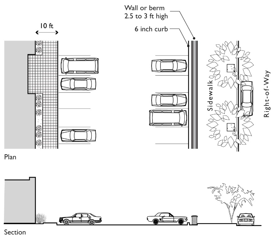
FIGURE 11-7-3.B(1): SCREENING AND SEPARATION OF PARKING AREA
5.
Materials and Colors. Buildings and structures shall be constructed of durable, high-quality materials appropriate for the climate, such as brick, stone, integrally tinted and textured masonry block, precast concrete, wood, architectural metals, natural and synthetic stone, stucco and synthetic stucco, and glazing.
a.
To reduce the apparent massing and scale of buildings, facades shall incorporate at least three (3) different and distinct materials.
b.
No more than fifty percent (50%) of the total façade may be covered with one (1) single material.
c.
Buildings larger than 10,000 square feet shall be finished with more than one (1) color on all elevations that are visible from public streets.
6.
Alternative Compliance. Site Planning and Design Standards are not intended to limit creative solutions. Conditions may exist where strict compliance to Site Planning and Design Standards of this Chapter are impractical or impossible, or where maximum achievement can only be obtained through alternative compliance. Alternative compliance does not modify or reduce requirements of the Building Code or any other chapters or sections of the Zoning Code. Alternative compliance allows development to satisfy the Site Planning and Design Standards in this chapter by providing comparable standards in a creative way.
a.
Requests for alternative compliance may be accepted for any application to which Site Planning and Design Standards apply. A written request must be provided in conjunction with the applicable land use application describing how the proposed alternative meets the criteria below.
b.
The approving body shall find that the request meets one (1) or more of the following criteria:
i.
Topography, soil, vegetation or other site conditions are such that full compliance is impossible or impractical; or improved environmental quality would result from alternative compliance.
ii.
Space limitations, unusually shaped lots and prevailing practices in the surrounding neighborhood, may justify alternative compliance for bypassed parcels and for improvements and redevelopment in older neighborhoods.
iii.
Safety considerations make alternative compliance necessary.
iv.
The proposed alternative is aesthetically more complementary to the site, better fits into the context of the area, improves the overall architectural appeal of the area and/or meets or exceeds the urban design characteristics as described in the City's General Plan.
(Ord. No. 5541, § 2, 12-9-19; Ord. No. 5928, §§ 12, 13, 2-3-25)
11-7-4: - REVIEW OF PLANS
Permit and review procedures shall follow the standards established in Article 7, Administration.
(Ord. No. 5541, § 2, 12-9-19)
11-8-1: - PURPOSE
A.
General Purposes. The Downtown districts are intended to promote the development and redevelopment of land within the Downtown Area to insure the future growth and vitality of the original square mile and adjacent areas (See Map 11-8-2). The regulations of this chapter are also intended to promote sustainable development patterns and encourage the development of high-intensity land uses where appropriate and where such uses add to the visual image and sense of place of Mesa's Downtown.
B.
Specific Purposes of Each District.
1.
Downtown Residence Districts (DR-1, DR-2, DR-3). In order to maintain a viable downtown area, stable residential neighborhoods must be protected and enhanced. The purpose of the DR Districts is to protect existing residential uses and to encourage the redevelopment of blighted or under-utilized sites for new residential usage. It is also the purpose of these districts to encourage pedestrian linkages between residential neighborhoods and the business, cultural and entertainment core of Downtown. It is the intent of the DR Districts to retain a real and perceived sense of neighborhood in urban-oriented residential areas by excluding most non-residential uses. It is also the intent of these districts to enhance the quality of residential neighborhoods through establishing compatible architectural and site design elements and regulating residential densities. The numerical designators -1, -2, and -3 are applied to the DR Districts to represent different development intensities.
2.
Downtown Business District 1 (DB-1). The purpose of the DB-1 District is to provide for general retailing, services, and medium-density residential uses. It is the intent of this district to allow multiple residences, professional office, and commercial uses as a major component of the Downtown Area.
3.
Downtown Business District 2 (DB-2). The purpose of the DB-2 District is to provide for a combination of intensive commercial, light manufacturing, and related uses. The intent of the district is to provide a suitable location for those commercial and manufacturing uses which may require arterial street or railway access.
4.
Downtown Core District (DC). The purpose of the Downtown Core District is to encourage the highest intensity of land uses to be developed, redeveloped and maintained within the Downtown. It is also the purpose of the DC District to provide incentives for the development or redevelopment of under-utilized and bypassed properties within Downtown and to promote the development of a vital, vibrant activity area. The regulations for the DC District are intended to ensure that higher-intensity land uses are appropriate for the fulfillment of the purpose of the Downtown Core District as a vibrant focal point for the city. At the same time, the Downtown Core District is created to serve residents, businesses, employees and visitors and to ensure that the visual image of the core of the Mesa Downtown will be maintained and enhanced.
(Ord. No. 3746, 2-22-00)
11-8-2: - APPLICABILITY
The Downtown Area is established within the area bounded by University Drive, Broadway, Country Club Drive, Mesa Drive, Second Street, Second Avenue, and LeSueur and on property adjoining or within 300 feet of the rights-of-way bounding this area in the furtherance of the stated purpose and intent of this Section. If this 300-foot distance puts at least ½ of a property within the Downtown Area, the entire property shall be within the Downtown Area; if less than ½ of the property is within the area then the entire property will be outside the Downtown Area.
11-8-3: - LAND USE REGULATIONS
In Table 11-8-3, which follows, the land use regulations for each Downtown zoning district are established by letter designations as follows:
• "P" designates use classifications permitted in downtown districts.
• "TUP" designates use classifications permitted on approval of a Temporary Use Permit
• "SUP" designates use classifications permitted on approval of a Special Use Permit.
• "CUP" designates use classifications permitted on approval of a Council Use Permit.
• "(x)" a number in parentheses refers to limitation following the table.
• "—" designates a prohibited use.
Use classifications not listed are prohibited. The "Additional Use Regulations" column includes specific limitations applicable to the use classification or refers to regulations located elsewhere in this Ordinance.
(Ord. No. 3817, 2-22-00; Ord. No. 4280, 10-4-04; Ord. No. 5096, 6-4-12; Ord. No. 5544, § 3, 12-9-19; Ord. No. 5592, § 4, 12-1-20; Ord. No. 5632, § 1, 7-8-21; Ord. No. 5758, § 1, 12-8-22; Ord. No. 5759, § 1, 12-8-22; Ord. No. 5813, § 1(Exh. 1), 10-16-23; Ord. No. 5814, § 1(Exh. 1), 10-16-23; Res. No. 12269, § 6, 9-23-24; Ord. No. 5883, § 3, 10-7-24; Ord. No. 5904, § 9, 12-2-24; Ord. No. 5928, § 14, 2-3-25; Ord. No. 5989, § 3, 12-8-25; Ord. No. 5976, § 3, 1-12-26)
11-8-4: - DEVELOPMENT STANDARDS—DOWNTOWN RESIDENCE DISTRICTS
Table 11-8-4 prescribes the development standards for the DR districts. The "Additional Standards" column lists additional standards that apply. Section numbers in this column refer to other sections of the Zoning Ordinance, while individual letters refer to subsections that directly follow the table.
A.
Transitional Standards. For a residential structure in the DR-3 District that is adjacent to the DR-1 District or the DR-2 District, the following shall apply:
1.
Front Yard Setback. The required front-yard setback shall be the same as that in the DR-1 and DR-2 Districts, i.e. 15 feet from the street right-of-way. This 15-foot front yard setback shall be required for the first 40 feet of lot street frontage adjacent to the DR-1 or DR-2 District.
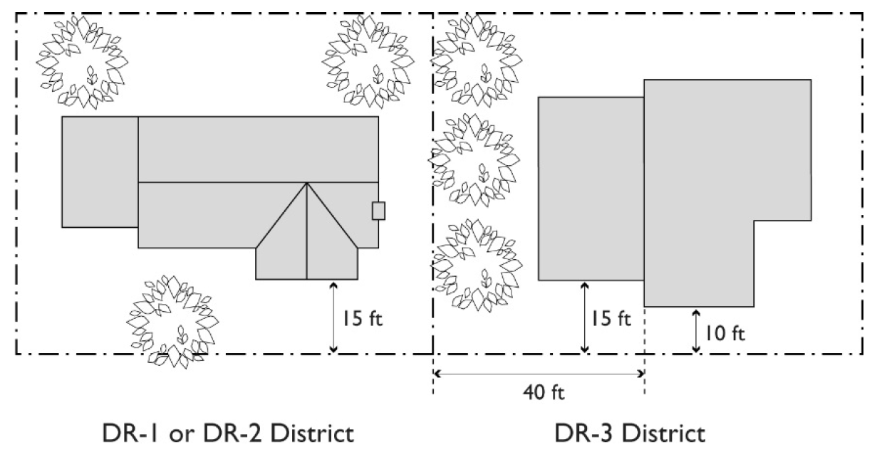
FIGURE 11-8-4.A.1: TRANSITION TO RESIDENTIAL STRUCTURE IN DR-3 DISTRICT
2.
Roof Profile. The relative height and roof profile of new residential structures in the DR-3 District shall complement and be compatible with the roof profiles of residential structures in the adjacent DR-1 or DR-2 Districts.
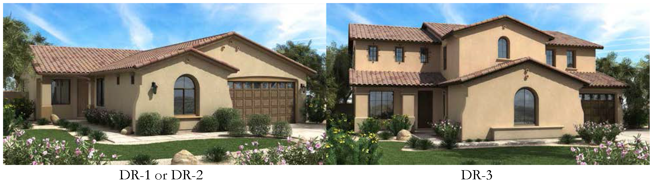
FIGURE 11-8-4.A.2: TRANSITION TO RESIDENTIAL STRUCTURE ROOF PROFILE
Roof Profile, in this context, refers to the relative height of a roof or roofs of a building, together with the shape or form of the roof structure that are placed above residential dwelling units, such as gable, gambrel, hip, mansard, parapet, pitched and shed.
B.
Minimum Open Space.
1.
Single Residence Detached and Attached. Single residence detached and attached developments in the DR-1, DR-2, and DR-3 Districts, shall have a minimum of 400 square feet of individual, private outdoor space for each dwelling unit provided adjacent to the dwelling unit.
2.
Multiple Residence Developments. Multiple residence developments in the DR-2 and DR-3 Districts, shall have a minimum of 200 square feet of open space for each dwelling unit. This open space shall not include any required front or side yard. The open space requirement shall be provided by one of the following options.
a.
At least 200 square feet of private open space or patio area attached to the individual unit,
b.
A private balcony or deck of at least 60 square feet in area adjacent to the individual dwelling unit and the remainder of the open space (140 square feet per unit) provided in a usable common open-space, or
c.
Where no individual private open space is provided adjacent to a dwelling unit, 300 square feet per dwelling unit shall be required to be provided in a usable common open space.
C.
Landscaping.
1.
Landscaping materials and quantities shall be installed and maintained in compliance with Chapter 33, Landscaping, unless specified by a landscape design plan or specific redevelopment plan adopted by the City Council. The following landscaping regulations shall also apply:
a.
Existing lawns and/or vegetated ground cover shall be maintained in the street right-of-way area between the curb and the property line.
b.
The required front yard area shall be maintained in lawn and/or vegetative ground cover. In the DR-1 and DR-2 Districts not more than 20 percent of the front-yard ground cover shall be inorganic materials.
c.
The required quantity of trees, shrubs and vegetation, as specified in Chapter 33, shall be located in the street right-of-way and in the required front-yard setbacks. Where conflict occurs between the requirements of Chapter 33 and the minimum yards listed in this Chapter (in Table 11-8-4), the minimum yards listed in this chapter shall prevail.
d.
All required yard areas shall be landscaped, as specified in Chapter 33, Landscaping, and maintained free from encroachments.
e.
Where a parcel is used for multiple residences, or office, the required side and rear yards shall also be landscaped.
D.
Screening. Whenever a new multiple residence is constructed, or floor area is added to an existing single residence to convert it to a multiple residence use, a privacy wall shall be constructed along the property lines separating the multiple residence use, its parking areas and driveways from any adjacent existing single residence. Conversion of existing single residence without increasing floor area does not invoke the screening requirement. The privacy wall shall be of masonry construction with stucco, mortar wash or other finish to match that of the main building and shall be 6 feet in height. The privacy wall shall extend along interior side lot lines to the front-yard setback of the main building or to the front-yard setback of the existing adjacent residence, whichever is closer to the street right-of-way, but shall not extend past the setback into the front yard without being reduced in height to a maximum of 3 feet. All other screening standards of Section 11-30-9 shall apply.
(Ord. No. 3423, 1-20-98; Ord. No. 3430, 1-20-98; Ord. No. 3817, 2-22-00; Res. No. 12269, § 7, 9-23-24; Ord. No. 5883, § 3, 10-7-24)
11-8-5: - DEVELOPMENT STANDARDS—DOWNTOWN BUSINESS DISTRICTS
Table 11-8-5 prescribes the development standards for the DB districts. The "Additional Standards" column lists additional standards that apply. Section numbers in this column refer to other sections of the Zoning Ordinance, while individual letters refer to subsections that directly follow the table.
A.
Intrusion on Adjacent Residential. Multi-storied structures with windows on sides adjacent to residential districts or uses shall utilize methods such as increased setbacks, window screens, and/or window placement, as determined by the Planning Director, to limit intrusion on the adjacent residential district or use.
B.
Landscaping. Landscape materials and quantities shall be installed and maintained in compliance with Chapter 33, Landscaping, unless specified by a landscape design plan or specific redevelopment plan adopted by the City Council. The following landscape requirements shall also apply:
1.
The required front-yard setback and street right-of-way area shall have low-water usage, vegetative ground cover and plants; no more than 20 percent may be covered with inorganic materials. Street rights-of-way shall be landscaped in accordance with any landscape design plan or specific redevelopment plan adopted by the decision making authority.
2.
The required quantity of trees, shrubs and vegetation specified in Chapter 33, Landscaping, shall be located in the required front-yard setback and street right-of-way area. Front yards shall be as noted in Table 11-8-5 of this section. Where conflict occurs between the landscaped setbacks specified in Chapter 33, and the yard requirements of this section (in Table 11-8-5), the yard requirements of this section shall prevail.
3.
Landscaping also shall be installed and maintained free from encroachments such as parking spaces, driveways, mechanical equipment or buildings in side and rear yards as specified in Chapter 33, Landscaping.
C.
Screening. In addition to the screening standards of Section 11-30-9, Screening, the following standards shall apply:
1.
A 6-foot masonry wall with mortar wash finish, stucco or other finish, designed to match the main building on the site, shall be installed with the first phase of commercial development along all interior property lines adjacent to residential districts or uses.
2.
All refuse and ground mounted mechanical equipment areas shall be:
a.
Screened on at least 3 sides by 6-foot high masonry walls,
b.
Located at least 10 feet away from adjacent residential property lines and
c.
Shall not be located within required street-yard setbacks.
D.
Additional Height to Buildings. For sites located within DB-1 or DB-2 districts, additional height may granted, up to a 20-percent increase over the district maximum, through a site plan review hearing by the Planning & Zoning Board.
(Ord. No. 3423, 1-20-98; Ord. No. 3817, 2-22-00)
11-8-6: - DEVELOPMENT STANDARDS—DOWNTOWN CORE DISTRICT
This section establishes standards for the Downtown Core District.
A.
Density, Area, Buildings and Yards. Minimum lot area and yard setbacks will vary according to the type of development, the proposed use, and the size, scope and density of the project. The decision making authority or designee may determine that certain projects shall be reviewed by the Planning & Zoning Board who shall determine the specific density, area, building, and yard regulations for such projects. Maximum residential densities and building heights are through approval by the Planning & Zoning Board.
B.
Landscaping.
1.
Conformance with U Designator Standards. All landscape designs, materials and quantities and maintenance shall conform to "-U" designator standards as specified in Chapter 33, Landscaping, unless specified by a landscape design plan or specific redevelopment plan adopted by the decision making authority.
2.
Landscape Materials. Landscape materials shall be used to enhance street right-of-way and building frontages by the following:
a.
Street trees shall be planted in street right-of-way areas consistent with adopted City streetscape plans and also may be installed in on-site pedestrian walkway areas and plazas.
b.
Building foundation plantings shall be conform to "-U" designator standards specified in Chapter 33 unless specified by a landscape design plan or specific redevelopment plan adopted by the decision making authority.
C.
Parking. In addition to the regulations of Chapter 32, On-Site Parking, Loading, and Circulation, and Section 11-8-7(A) and (B) of this chapter, the following standards apply to the DC District:
1.
Covered multi-level parking structures are encouraged; open surface parking shall be discouraged.
2.
All parking area and structure designs and off-site parking accommodations are subject to approval by the Planning & Zoning Board through site plan review.
(Ord. No. 3423, 1-20-98; Ord. No. 3817, 2-22-00)
11-8-7: - SUPPLEMENTAL REGULATIONS FOR ALL DOWNTOWN DISTRICTS
A.
Parking. In addition to the standards of Chapter 32, On-Site Parking, Loading, and Circulation, the following standards apply to the Downtown districts.
1.
Off-Site Parking. Required parking may be provided off-site in a privately or municipally owned parking garage, commercial parking lot or other approved facility. If such off-site parking is leased, the length of the term of such lease shall be the same as the length of the term of the lease of the property for which such spaces are provided. Terms of the lease shall be provided upon request of the city.
2.
Shared Parking. Required parking spaces may be shared between differing commercial and mixed-use projects when located on the same or adjacent parcels, if the principal operating hours of the uses involved are significantly different, i.e. daytime versus nighttime uses. Assurances of different operating hours for each use must be provided in writing in a form acceptable to the Zoning Administrator, pursuant to Section 11-32-5.
3.
Enclosed Structures. In the DR-1 and DR-2 Districts, enclosed structures shall be provided for required parking when the parking space is located in the front half of a lot.
4.
Interconnectivity. In the DB-1 and DB-2 Districts, parking areas should be interconnected on- site to allow vehicular access between parcels and to avoid numerous driveway cuts along street rights-of-way.
B.
Loading. In addition to the standards of Chapter 32, On-Site Parking, Loading, and Circulation all non-residential uses shall demonstrate availability of convenient, paved space for loading and unloading of commercial vehicles within 300 ft. of the site.
C.
Building Projections into Required Yards. Building projections may extend into required yards, subject to the following standards:
1.
No projection may extend closer than 2 feet to an interior lot line or into a public utility easement.
2.
Awnings, eaves, overhangs, or basement window wells may encroach up to 3 feet into any required yard.
3.
Vestibules, bay windows, nooks, chimneys, or similar wall projections with or without footings may encroach not more than 3 feet into any required front or rear yard and not more than 2 feet into any required side yard, provided the aggregate width of all such projections adjacent to any yard does not exceed ⅓ of the length of the building wall.
4.
Staircases may encroach up to 3 feet into any required front yard, and up to 10 feet into any required rear yard.
5.
Attached open porches, open patios, open carports or open balconies may encroach to within 10-feet of the rear property line. Such open structures may include window screens, knee walls, and other partial enclosures as specified in the Building Code for patio covers.
6.
In DR-1 and DR-2 districts only, enclosed rooms may encroach up to 10-feet into a required rear yard for up to one-half the width of the building, provided a minimum of 10-feet remains between the building face and the rear property line.
(Res. No. 12269, § 8, 9-23-24; Ord. No. 5883, § 3, 10-7-24)
11-8-8: - REVIEW OF PLANS
Permit and review procedures shall follow the standards established in Article 7, Administration.
11-10-1: - PURPOSE
The purpose of the Public and Semi-Public (PS) District is to accommodate large-scale governmental, public utility, recreational, and educational facilities. It is the intent of this district to:
A.
Recognize those uses that are provided by public entities for public usage and convenience;
B.
Ensure high quality development;
C.
Encourage the use of sustainable development practices; and,
D.
Insure compatibility with surrounding uses.
11-10-2: - LAND USE REGULATIONS
Facilities owned, leased, or operated by city, county, state, or federal governments or agencies thereof or school districts are considered permitted in this district. In addition, Table 11-10-2, which follows, specifies additional land use regulations for each Public and Semi-Public zoning district, established by letter designations as follows:
• "P" designates use classifications permitted in public and semi-public districts.
• "TUP" designates use classifications permitted on approval of a Temporary Use Permit
• "SUP" designates use classifications permitted on approval of a Special Use Permit.
• "CUP" designates use classifications permitted on approval of a Council Use Permit.
• "(x)" a number in parentheses refers to limitation following the table.
Use classifications not listed are prohibited. The "Additional Use Regulations" column includes specific limitations applicable to the use classification or refers to regulations located elsewhere in this Ordinance.
(Ord. No. 5759, § 1, 12-8-22; Res. No. 12269, § 9, 9-23-24; Ord. No. 5883, § 3, 10-7-24; Ord. No. 5976, § 3, 1-12-26)
11-10-3: - DEVELOPMENT STANDARDS
Table 11-10-3 and the subsection that follows it prescribe the development standards for the PS District.
A.
Buffer Yards. A screening wall 6 feet in height is required wherever a lot located in the PS District abuts an R or DR district at the time of development. In addition, if a lot in the PS District abuts a lot in an RS or DR-1 district at the time of development, a landscape buffer of at least 15 feet wide shall be provided on the PS-zoned lot.
(Ord. No. 5814, § 1(Exh. 1), 10-16-23)
11-10-4: - REVIEW OF PLANS
Permit and review procedures shall follow the standards established in Article 7, Administration.
11-11-1: - PURPOSE AND INTENT
The purposes of the Planned Community (PC) District are to:
A.
Accommodate large-scale, unified and comprehensively planned developments that encourage and promote innovative and sustainable residential and non-residential land uses;
B.
Allow flexibility for innovative and high quality development while meeting the goals of the Mesa General Plan and establishing planning and development control parameters tailored to the opportunities and constraints of the property;
C.
Conserve scarce energy resources, using technologies, materials and designs that are sustainable;
D.
Provide for creative and high quality design and materials, for buildings and landscape, to accomplish efficient, aesthetic, sustainable, and desirable development that highlights special features of the geography, topography, size, or shape of a particular property and that include exceptional public amenities and facilities;
E.
Provide environmental improvements that mitigate air and storm water pollution. Provide shade and reduce the effects of the urban heat island;
F.
Ensure that areas designated as neighborhood centers, urban centers or regional centers in the Mesa General Plan contain an appropriate variety and mix of employment, office, retail, medical, educational, community service, tourism, entertainment, open space, recreational, and residential uses to provide center(s) with a sense of place within the community;
G.
Ensure that residential neighborhoods utilize a variety of housing types and densities that contain parks and schools that are located within convenient walking or bicycling distance from all homes, and neighborhood village centers with shops, restaurants, service uses, schools, and other civic uses that provide each neighborhood an individual identity and foster community interaction;
H.
Ensure that demands on streets, utilities and other public infrastructure do not exceed the capacity of existing or planned facilities, and ensure that the development will accommodate new and future technologies for utilities and other public infrastructure;
I.
Provide reasonable assurances to the City and land developer that the proposed development may be planned and carried out in one or more phases over an extended period, in accord with an approved Community Plan; and
J.
Provide for cohesive development patterns that integrate well with surrounding development; and encourage a variety of transportation options.
(Ord. No. 5928, § 15, 2-3-25)
11-11-2: - LAND USE AND DEVELOPMENT REGULATIONS
A.
General Plan and Zoning. PC Districts may be established within areas designated mixed residential, urban residential, neighborhood center, urban center, or regional center in the Mesa General Plan. The PC District and adopted Community Plan are the zoning for the property. The adopted Community Plan also is the principal reference for implementation and review of future development within the boundary of the overall site. All development that takes place within the boundaries of a PC District shall be governed by and built in accordance with the adopted Community Plan or approved amendments to the Community Plan.
B.
Minimum Area. The minimum area required for a PC District is 160 contiguous acres.
C.
Permitted Uses and Land Use Groups. The permitted and conditional land uses for a PC District shall be listed in, and established by, an adopted Community Plan. As part of the Community Plan, the uses shall be individually listed for each development unit, and the uses shall be grouped into land use groups. A land use group may be subdivided into sub-land use groups. Such groups may be based in whole or in part on existing Mesa Base Zoning Districts or may be new categories. In addition to listing all permitted uses in the land use groups and any sub-land use groups, the Community Plan shall have a narrative describing the intent and purpose for each.
1.
The Community Plan. The Community Plan may establish any land use as a conditional use that requires review and approval of Council Use Permit, Special Use Permit, or Administrative Use Permits in accordance with Chapter 70 of this Title.
2.
Land Use Budget. In the Community Plan, the land use groups and any sub-land use groups shall be designated for each development unit, and have a minimum and maximum range (the land use budget) for each designated land use group and/or the budget may be specific to sub-land use groups or individual land uses. The land use budget shall be expressed in the following manner:
a.
Dwelling units (DU) shall be used as the measure to express the number of residences.
b.
The density of a residential project, expressed as a ratio of the number of dwelling units per acre (DU /AC), shall be the measure of the intensity of a Residential Land Use.
c.
Gross Floor Area (GFA) shall be the measure used to express the amount of mixed and non-residential land use.
d.
Floor Area Ratio (FAR) shall be the measure used to express the intensity of development for all mixed and non-residential land uses.
e.
The approved Community Plan may include additional measures for the land use budget.
f.
The amounts (e.g. DU, GFA) and intensities (e.g. DU /AC, FAR), expressed in minimum and maximum ranges, for each land use group (and any sub-land use groups or specific land uses) for the development units, in aggregate, shall not exceed the total adopted for the Community Plan.
3.
Development Unit Land Use Plan. With the approval of each development unit there shall be a Development Unit Land Use Plan that shall identify:
a.
The general location for the land use group and any sub-land use group (and may identify general locations for specific uses),
b.
The approximate amount of acreage for such group (or specific use),
c.
The intensity of development proposed at each location.
4.
Site Plan. With the approval of each Site Plan the permitted uses shall be specified on the Site Plan by reference to sub-land use group(s) or specific uses. Permitted uses at a specific site shall be limited to those specified on the approved Site Plan; all other uses are prohibited.
D.
Development Standards. The Community Plan shall specify General Development Standards, as defined in Chapter 87, for the PC District.
1.
Application of the General Development Standards. The General Development Standards shall apply to each development unit, site plan, and all development in the PC District.
2.
Zoning Ordinance Standards as Default Standards. Site plans and improvements to individual lots or sites shall conform with the standards set forth in the Zoning Ordinance (the Zoning Ordinance Standards) for the district or use most nearly approximating the proposed uses, where applicable, and intensities of use unless the approved General Development Standards for the adopted Community Plan include a specific standard.
a.
Modifications to Default Standards. The Community Plan may establish a process that authorizes the Zoning Administrator to grant minor modifications to an applicable Zoning Ordinance Standard and/or General Development Standards.
b.
Criteria for Modifications to Default Standards. The Zoning Administrator shall use, at a minimum, the following criteria when evaluating all requests for minor modifications to Zoning Ordinance Standards and/or General Development Standards:
i.
The minor modification is consistent with the application of design requirements designated in the Community Plan; and
ii.
The minor modification is consistent with the implementation of the Community Plan and the Development Unit Plan; and
iii.
The minor modification will result in a project design that meets or exceeds the design goals and guidelines as expressed by the Community Plan; and
iv.
The minor modification results in a building of superior architectural design, as determined by building form and massing, use of materials and colors, and relationship of the building to the building site; and
v.
The minor modification is in accord with the Mesa Building Code and adopted Engineering Division requirements, as may be applicable.
E.
Standards not in the Zoning Ordinance. Modifications to development standards not established within the Zoning Ordinance shall be in accordance with procedures and processes established in the Mesa City Code. With the application of the PC District, certain modifications may be sought in accordance with 9-5-3(C), 9-6-7(C), and 9-8-4(C).
11-11-3: - APPLICATION REQUIREMENTS
A.
Pre-Submittal Conference. A pre-submittal conference with the City Planning Director and Engineer, or their designees, is required prior to submittal of an application for PC District zoning. The applicant shall provide a description of the boundary of the proposed PC District, a conceptual land use summary and budget, proposed development units, project narrative, proposed General Development Standards, and any proposed modifications that may be sought in accordance with sections 9-5-3(C), 9-6-7(C), and 9-8-4(C).
B.
Application and Submittal Requirements. In addition to the requirements for rezoning amendments as described in Chapter 76 of this Title, each application for rezoning to the PC District shall be accompanied by the following information. Submittals that fail to include all of the items listed in the below subsections shall not be scheduled for consideration.
1.
An application form, available in the Planning Division office, and payment of required fees.
2.
A map showing the ownership of the property within the proposed PC District, and a current Title report for the property.
3.
The name(s) and current address(s) of the applicant, owner, and developer.
a.
If the applicant, owner or developer is a corporation, the names and current addresses of the principal officers and members of its board of directors shall be submitted in addition to the information required above.
b.
If the applicant, owner or developer is a partnership, the names and current addresses of the general and managing partners shall be submitted in addition to the information required above.
c.
A material change in any of the information regarding the identity of the applicant, owner or developer or in any address thereof shall be filed with the City within 30 days of the change.
4.
A legal description with dimensions and bearings of the proposed PC District boundary.
5.
A narrative describing and explaining how the proposed PC District and Community Plan complies with and meets the purpose, intent, and requirements of the Mesa General Plan and the PC District. This narrative shall be separate from the Community Plan.
6.
Development Schedule shall be submitted as part of the Community Plan that includes the following:
a.
The timeframe in which construction or development is expected to begin and the estimated duration of time required for completion of all development including public infrastructure improvements necessary to serve the Community;
b.
Anticipated phasing, including phasing of infrastructure improvements, if the project will not be developed as one unit, including a plan for the interim use, maintenance and management of the undeveloped phase or phases;
c.
The anticipated completion of development for each development unit; and
d.
Anticipated initiation and completion dates for each phase or development unit, in no greater than three-year increments.
7.
A Community Plan, which shall include all the minimum required elements listed in Section 11-11-4.
C.
Evaluation. The Planning & Zoning Board and City Council shall consider at a minimum the following goals and objectives when evaluating the proposed Community Plan. The proposed Community Plan should:
1.
Conform to applicable policies, land use map designations, and land use definitions of the Mesa General Plan;
2.
Conform to the purposes and intents of the PC District as listed in Section 11-11-1;
3.
Provide the following when the PC District is located on a site designated as a mixed residential, urban residential, neighborhood center, urban center, or regional center placetype on the Mesa General Plan placetype map:
a.
A mix of land uses in a wide variety of building forms which creates a complete community environment; and
b.
An appropriate mix of non-residential uses, including commercial, employment (such as office and industrial), and public/semi-public, in addition to multiple forms of residential uses; and
c.
One or more areas designated as villages or urban cores that will serve and complement surrounding residential development.
4.
Provide a combination of land uses that are arranged and designed in such a manner as to be well integrated with other land uses, the immediate surrounding area, the planned thoroughfare system, and other public facilities such as water and sewer systems, parks, schools, transit routes and utilities.
5.
Include adequate provisions and sites for schools, playgrounds, parks, trails, and other recreational facilities that are adequate to serve the anticipated population and interconnected with other public open spaces and recreational resources within the city.
6.
Adequately, reasonably, and conveniently integrate into existing and planned streets, transit systems, and public services, utilities, and public facilities and will not result in a reduction in service levels to adjacent properties.
7.
Promote development that is appropriate to and well integrated with its environmental setting, including existing vegetation, soils, geology, topography, and drainage patterns.
8.
Preserve, where possible, any significant historical, cultural, and archaeological features of the site.
9.
Provide superior design and environmental sustainability in comparison with development reviewed under other base zoning district regulations.
10.
Provide a level of detail that adequately describes the relative quality and design themes of the built environment of the project, both at completion and during the phased implementation of the Community Plan.
11.
Be compatible with, and not detrimental to, adjacent properties or the surrounding neighborhood(s).
D.
Conditions. The City Council may place conditions on its approval of a PC District, Community Plan, and/or modifications to either a PC District or a Community Plan. Such conditions of approval may include, but are not limited to: conditions to ensure implementation of the Community Plan in accordance with the Mesa General Plan, and other applicable plans and policies adopted by the City; conditions to achieve the purposes and intents described in Section 11-11-1; and, conditions requiring additional or different approval processes for development units, design guidelines, site plans, and/or areas within the PC District.
(Ord. No. 5928, §§ 15—17, 2-3-25)
11-11-4: - COMMUNITY PLAN REQUIRED
A.
Contents. A Community Plan shall be submitted concurrently with the application for the PC District, and shall include the following:
1.
Community Plan Map. A map, which may consist of multiple sheets, drawn to a suitable scale and that includes the following elements:
a.
The boundary with dimensions and bearings of the proposed PC District.
b.
Division of the entire site into separate land development increments, referred to as Development Units. The size and number of Development Units shall be sufficient to provide understanding of the pattern, phasing and intensity of development authorized by the Community Plan.
c.
The approximate location of proposed freeways, parkways, arterial streets, and streets which provide connectivity between development units and other major transportation and transit corridors.
d.
Major drainage elements within the proposed PC District and vicinity.
e.
Existing and proposed utility corridors.
f.
Any major trails and/or bikeways, including their proposed connections to conceptual trail locations identified in the Mesa General Plan or other applicable plans adopted by the city.
g.
Location of any known significant historical, cultural, and archaeological features of the site.
2.
Land Use Regulations. Permitted land uses, land use groups, and any sub- land use groups, as described in Section 11-11-2(C), and a Land Use budget, as described in Section 11-11-2(C)(1).
3.
Master Developer. The Community Plan shall identify a Master Developer or other entity that shall be designated to ensure all future development requests are in compliance with the land use budget and in compliance with the provisions of the Community Plan.
4.
Community Facilities Element. A narrative describing the estimated need for community facilities, including public schools, parks, open space, fire stations, police substations and other similar community facilities, by type and land area.
5.
Infrastructure Element. Major street system and transportation plan, and Utilities and storm water drainage master plans.
6.
General Development Standards. Defined in Chapter 87 of this Title.
7.
Design Guidelines. Community Plan Design Guidelines for the development of the property, including illustrations of proposed architectural, urban design, streetscape, and landscape concepts, thematic design elements such as architectural materials, building colors and landscape plants, and any proposed variation from Chapter 30, General Site Development Standards. The Community Plan Design Guidelines may describe broadly based design or architectural themes and concepts, sufficient to convey an idea and general pattern of development. With the application of the Development Units and Development Unit Design Guidelines shall be submitted that are consistent with, and provide further detail to, the Community Plan Design Guidelines.
8.
Supplemental Reports. Each Community Plan shall be accompanied by the following supplemental reports, as determined by the Planning Director and City Engineer at the time of the Pre-Submittal Conference.
a.
Traffic impact analysis, soils engineering report, geology report, and/or drainage report.
b.
Additional information as necessary to facilitate understanding, review and action on the application by the Planning & Zoning Board and the City Council.
9.
Requirements and Administration for Future Development Unit Plans. Consistent with, and in addition to the requirements in this Chapter, the Community Plan shall set forth additional elements for the Development Unit Plans, additional submittal and process requirements for Development Unit Plans and amendments thereto, and additional criteria for reviewing Development Unit Plans. Such additional requirements shall include, but are not limited to, the process and public body or position that reviews, and may approve, future Development Unit Plans. Such additional elements and criteria shall include, but are not limited to, criteria and requirements to ensure that future development plans will facilitate development compatible with adjacent properties and surrounding neighborhoods, will facilitate the implementation of the Community Plan, will facilitate appropriate transitions between differing developments, and will not overburden the transportation system, utility infrastructure or community facilities. If a Development Unit Plan Application is filed prior to the approval of the Community Plan, such a Development Unit Plans may be approved by City Council with the approval of the Community Plan.
10.
Requirements and Administration for Future Site Plans. Consistent with, and in addition to the requirements of this Chapter, the Community Plan shall set forth additional elements required of Site Plan Review, additional submittal and process requirements for a site plan, Site Plan Modification, and additional criteria for review or modification of site plans. Such additional requirements shall include, but are not limited to, specifying how Site Plan Review requirements will be administered within a development unit, and set forth the review and approval process for Site Plan Review. Such additional elements and criteria shall include, but are not limited to, criteria and requirements to ensure that site plans will facilitate development compatible with adjacent properties and surrounding neighborhoods, will facilitate the implementation of the Community Plan, will facilitate appropriate transitions between differing developments, and will not overburden the transportation system, utility infrastructure or community facilities.
B.
Review of PC District and Community Plans. The PC District and Community Plan shall be reviewed, and a recommendation to City Council shall be made, by the Planning & Zoning Board. The Community Plan Design Guidelines shall also be reviewed, and a recommendation to City Council shall be made, by the Planning & Zoning Board. The PC District and Community Plan shall be reviewed, and are subject to approval by City Council. These processes shall be in accordance with the requirements of this Chapter 76 of this Title.
(Ord. No. 5928, § 18, 2-3-25)
11-11-5: - REVIEW AND CONSIDERATION OF DEVELOPMENT UNIT PLANS
A.
Pre-Submittal Conference. A Pre-Submittal Conference with the City Planning Director and Engineer, or their designee, is required prior to submittal of a Development Unit Plan Application.
B.
Consideration of Request. Development Unit Plans shall be reviewed, and are subject to approval, in accordance with the requirements and process established by the adopted Community Plan. The Development Unit Plans include, but are not limited to, Development Unit Design Guidelines and a Development Unit Land Use Plan.
C.
Development Unit Design Guidelines. Development Unit Design Guidelines shall be submitted that are consistent with, and provide further detail to, the Community Plan Design Guidelines. The Development Unit Guidelines shall include design themes, additional standards and concepts unique to the development unit, and shall be of sufficient detail to ensure cohesive, integrated, high-quality design. All site plans and development shall conform to, and be consistent with, the approved Development Unit Design Guidelines.
D.
Development Unit Land Use Plan. A Development Unit Land Use Plan, as described in Section 11-11-2(C)(3), shall be of sufficient detail to ensure the compatibility of future development in the unit and compatibility with properties surrounding the unit, to ensure appropriate transitions between differing developments, to ensure that development will not overburden the transportation system, utility infrastructure or community facilities, and to facilitate the implementation of the Community Plan. All site plans and development shall conform to, and be consistent with, the approved Development Unit Land Use Plan.
E.
Review of Development Unit Plans. Applications for Development Unit Plans within an adopted PC District shall only be approved if the application and supporting materials are consistent with the approved Community Plan, as well as any conditions or modifications of the Community Plan that were imposed by the City Council. In addition to the requirements and criteria established in this Chapter and Community Plan to evaluate development units. Development Unit Plans shall be consistent with the approved Community Plan as follows:
1.
The land use budget for a development unit shall remain identical to, or within the range established by the approved Community Plan budget for that development unit.
2.
Development Unit Plans shall be consistent with any major or minor amendments of the Community Plan.
3.
All other relevant policies and guidelines as outlined in the Community Plan shall remain as adopted.
11-11-6: - SITE PLAN REVIEW
A.
Pre-Submittal Conference. A Pre-Submittal Conference with the City Planning Director and Engineer, or their designee, is required prior to submittal of a site plan application.
B.
Site Plan Approval Required. All non-single residence development within a PC District shall require an approved site plan. All single residence developments shall meet this requirement through the subdivision process as required by Chapter 6, of Title 9 of the Mesa City Code. For all development requiring an approved site plan, no building permit shall be issued for such sites until there is an approved site plan.
C.
Site Plan Review. All sites shall be reviewed, and be subject to approval, by the Planning Director and his/her designees, unless otherwise designated by the adopted Community Plan.
D.
Review and Conditions. Site plans shall be reviewed for consistency with the requirements of this Chapter, the Community Plan and Development Unit Plans. Unless otherwise specified in the Community Plan, conditions may be imposed on the approval of any site plan as may be deemed necessary to ensure that the site is designed in a way to facilitate compatibility with adjacent property and to ensure that the development will be in accordance with the Community Plan, the General Development Standards, Community Plan Design Guidelines, Development Unit Design Guidelines, and the Land Use Budget. The Community Plan may establish additional criteria for such conditions. Consistent with this Chapter and any additional criteria established in the Community Plan such conditions may include:
1.
Revised building setbacks;
2.
Revised landscaping;
3.
Revised on-site parking and loading spaces;
4.
Height and area limitations on structures;
5.
Limited vehicular access;
6.
Placement and/or installation of walls, fences and screening devices;
7.
Installation of noise attenuating construction; and
8.
Off-site improvements in public rights-of-way adjacent to the subject property.
E.
Required Information. All applications for Site Plan Review for development within an approved PC District shall include drawings (drawn to scale) and other supporting materials and documents, as determined by the Community Plan. Additional materials and plans may be requested, as needed, by the Planning Director to determine the full compatibility of the project to neighboring development.
F.
Land Use Budget Update. The Master Developer shall review all site plans prior to submittal to ensure compliance with the land use budget. All site plans shall be submitted with a chart, approved by the Master Developer, updating the land use budgets for the Community Plan and the applicable Development Unit Plan.
G.
Permitted Uses. The permitted uses shall be limited to those identified on the site plan as described in Section 11-11-2(C)(4).
H.
Appeal of a Site Plan Review Decision Made by a City Board or the Planning Director. The applicant, any owner of property within 750 feet of the boundaries of the Site Plan Review case or the City Manager (or his designee) may appeal a Site Plan Review decision. The appeal shall be made in writing, specifying the grounds for the appeal, within 15 business days of the decision. An appeal from a decision by a City board shall be forwarded to the City Council for review and consideration. An appeal from a decision by the Planning Director shall be forwarded to the Planning and Zoning Board (unless specified otherwise in the Community Plan for review and consideration. It shall be the responsibility of the applicant to complete all citizen participation requirements. The appellate body shall rehear the request, and shall have the ability to affirm, reverse or modify the previous decision.
11-11-7: - EXPIRATION AND RENEWAL OF SITE PLAN REVIEWS
A.
Expiration. The approval of a site plan shall expire 2 years following the date of the approval, unless a building permit has been issued and construction diligently pursued.
B.
Extension. Site plan approval may be extended once for a period of not more than an additional two years by the Planning Director. Application for an extension shall be made in writing not less than 30 days after and not more than 60 days before the expiration of the original approval. The Planning Director may extend a site plan approval if the site plan remains consistent with the purpose and intent of this Chapter, the Community Plan, and the applicable Development Unit Plan.
C.
New Application. If the approval of a site plan expires and an extension to the approval is not, or cannot, be granted, a new application for Site Plan Review shall be filed.
11-11-8: - AMENDMENTS TO AN APPROVED PC DISTRICT
A.
Initiation. Amendments to a Community Plan may be requested by the Master Developer or an owner of property located within a PC District. Amendments requested by a property owner shall provide documentation that notice of such request has been provided to the Master Developer.
B.
Limitation of Affected Area. Amendments to the approved Community Plan may be limited to one or more development units and any proposed change will not extend to, or affect, another development unit unless specifically included in the area to be affected by the proposed amendment.
C.
Land Use Budget Transfer. A Community Plan may establish the process and criteria for permitting an unused portion of a development units' land use budget to be transferred to another development unit. To allow such transfers, the Community Plan must establish criteria to categorize transfers as major amendments or minor amendments. Such criteria shall be consistent with the requirements of this Chapter.
D.
Major Amendments. The Planning Director shall determine if the proposed amendment constitutes a major or minor amendment. If the Planning Director determines an amendment to be major, the amendment request shall be processed as an amendment to the PC District and Community Plan. An amendment will be deemed major if it involves any one of the following:
1.
A change in the overall PC District boundary.
2.
A change to the permitted uses in the PC District or any development unit.
3.
A change to the General Development Standards.
4.
An increase in the total number of approved dwelling units, floor area ratio (FAR) or gross floor area (GFA) for the overall PC District.
5.
A significant change to the boundary or gross area of a development unit from that approved in the PC District, as determined by the Planning Director. A 10 percent increase or decrease to the gross area of a development unit as approved in the PC District shall automatically be determined a significant change.
6.
Any change to the land use budget for the PC District. Any change to the land use budget for a particular development unit, except if the change is a result of an approved Land Use Budget Transfer.
7.
Any change in land use intensity that is likely to negatively impact or burden public facilities, transportation systems, major street systems, and utilities infrastructure as determined by the appropriate department head.
8.
Any proposed change to the Community Plan that substantively alters one or more components or required elements of the PC District or Community Plan as determined by the Planning Division.
E.
Minor Amendments. Amendments not meeting one or more of the criteria listed in above subsections shall be considered minor. If the Planning Division determines the amendment to be minor, the Planning Director may administratively act on the amendment and attach stipulations or conditions of approval thereto.
F.
Notice. Unless otherwise provided for in the Community Plan, notice of the proposed minor amendment shall be mailed, or otherwise made as determined by the Planning Director, to each owner of property as last disclosed by county assessor records, situated wholly or partly within 750 feet of the affected development unit(s) to which the amendment relates. For purposes of giving mailed notice, if required, the Planning Division shall require the applicant to prepare the letters, and stamp and address the envelopes of all affected property owners as determined above. The fully prepared letters will then be submitted to Planning Division staff, who will place the envelopes in the mail.
G.
Written protest. If written protest to any minor amendment is received from any notified property owner within 15 days of the notification mailing date and such protest cannot be resolved, then the minor amendment shall be reclassified as a major amendment. No additional application shall be required, however, all provisions governing major amendments shall then apply.
H.
Planning Director Decision. If written protest is not received as described above, the Planning Director shall render a decision on the minor amendment request. The Planning Director's decision shall be final unless appealed under section 11-11-9. The Planning Director or assigned designee shall send copies of the decision to the applicant, interested parties of record and members of the Planning & Zoning Board.
11-11-9: - ADMINISTRATIVE DECISION APPEALS
A.
Appeal to Planning and Zoning Board. An action or decision by the Planning Director on minor amendments may be appealed by the applicant, or by an owner of property located within 750 feet of the area affected by the minor amendment. The appeal shall be filed within 15 days from the date of the Planning Director's decision.
1.
Appeals shall be made in writing and submitted to the Planning Director, and
2.
Appeals shall include: the specific items being appealed, the conclusion the appellant believes should occur and why the initial decision should be changed. The Planning Division will submit a report and any background material regarding the appeal to the Planning & Zoning Board. The applicant associated with the action being appealed shall be informed by the Planning Division of the date, time and location of the appeal hearing.
3.
The applicant shall notify adjacent property owners of the Planning and Zoning Board meeting in the same manner as described in Section 11-11-8.
4.
The Planning and Zoning Board's decision on the appeal will be sent to the applicant and interested parties of record. The decision of the Planning and Zoning Board will be final, unless the applicant or an owner of property within 750 feet of the area affected by the minor amendment initiates an appeal to the City Council in accordance with Sub-section (B) of this Section.
B.
Appeal to Council. The applicant or an owner of property located within 750 feet of the area affected by the minor amendment or any action or decision involving a development unit plan or an appeal of a minor amendment to a Community Plan.
1.
The appeal shall be filed within 15 days of the board's decision.
2.
Appeals shall be made in writing and submitted to the Planning Director, and shall include: the specific items being appealed, the conclusion the appellant believes should occur, and why the initial decision should be changed.
3.
City Council's review on appeal is de novo. The City Council may consider any information before it when hearing an appeal under this Section. City Council may remand the matter for further proceedings or may affirm, reverse, or modify the decision.
11-11-10: - SUPPLEMENTARY PROVISIONS
A.
For the PC District, Community Plan, Development Unit Plan, Site Plan Review, and amendment thereto, notice and citizen participation shall be in accordance with Article 7, Administration this Ordinance, except an adopted Community Plan may modify these notice and citizen participation requirements for approvals and amendments that the Community Plan establishes are to be subject to approval by the Planning Director or designee.
B.
The owner(s) of property located in the PC District shall notify all prospective purchasers of the existence of the PC District and the Community Plan. Upon approval of the PC District, the owner(s) shall record a notice in the County Recorder's Office that provides notice to purchasers that the property is subject to the PC District and a Community Plan and that the development and use of the property is subject to other property owner's use of the Land Use Budget in the development unit.
C.
Prior to or with the approval of a PC District, there shall be a Development Agreement that includes Development Unit Phasing Schedule, Infrastructure Phasing Plan, and other terms to ensure that the future development fulfills the purposes of this Chapter and the Community Plan.
11-12-1: - PURPOSE
A.
General Purpose. The purpose of the Infill Development (ID) Districts is to promote and facilitate the development and redevelopment of by-passed, underutilized, or abandoned properties. This district provides for the establishment of specific land uses, development standards, alternative fees and streamlined review processes as incentives to stimulate re-investment and development of these properties in a manner that will contribute to the creation of a high quality context for employment opportunities and improve the overall economic viability of that area of the city. The ID Districts may be used when other tools available in the Zoning Ordinance will not work to address the needs of the properties involved. It is the intent of this district to:
1.
Encourage flexibility in the development, redevelopment, investment and reinvestment of by-passed, underutilized and/or abandoned properties that meet the criteria below for establishment of this district through the use of Infill Incentive Plans.
2.
Encourage the use of innovative approaches to development that utilize sustainable development practices and incorporate environmental performance standards.
3.
Where an urban form is anticipated or desired, encourage a mix of uses in close proximity of each other to promote pedestrian activity and reduce vehicle miles traveled. This goal includes consideration of off-site activities.
4.
Facilitate the development, redevelopment, and use of properties in Mesa where the public infrastructure is in place.
B.
Specific Purposes of Each District. There are two Infill Development districts:
1.
ID-1. The ID-1 District is for use with small sites of less than 5 acres that need relief from only a few development standards in order to develop or redevelop.
2.
ID-2. The ID-2 District is for use with sites of 2.5 acres or more that would benefit from a more comprehensive modification of standard development requirements in order to develop or redevelop.
11-12-2: - APPLICABILITY
An ID District may be established for any area where the City Council finds that the property meets the definition of "by-passed parcel" as defined in this Ordinance, without regard to lot size. The Council must also find that the area within the district meets at least 3 of the following requirements:
A.
There is a high percentage of vacant older or dilapidated buildings or structures;
B.
There is a high percentage of vacant or underused parcels of property, obsolete or inappropriate lot or parcel sizes, buildings designed for obsolete land uses, or environmentally contaminated sites;
C.
There is a high percentage of buildings or other places where nuisances exist or occur;
D.
There is an absence of development and investment activity compared to other areas in the City;
E.
There is a high occurrence of crime; or,
F.
There is a continuing decline in population.
11-12-3: - LAND USE REGULATIONS
A.
ID-1 Districts. Land use regulations will be established for a given ID-1 district by referencing a base zoning district established in this Ordinance in the Infill Incentive Plan (IIP) and in the ordinance adopting the zoning designation. The uses allowed in that referenced district will be allowed on the property following approval of the rezoning. Example, the adopting ordinance would state that the uses permitted would be the same as the LC, Limited Commercial District.
B.
ID-2 Districts. The land uses permitted in a given ID-2 district will be established uniquely for that district based on the Infill Incentive Plan (IIP) approved by City Council with the adoption of the ID district. The requirements for the IIP are described in Section 11-12-5.
11-12-4: - DEVELOPMENT STANDARDS
A.
ID-1 Districts. The General Development Standards established in this Ordinance and the specific development standards for the base zoning district are required, unless specifically modified by the City Council with the approval of the ID-1 district.
B.
ID-2 Districts. The General Development Standards and specific development standards for property zoned ID-2 shall be established through the review and approval of an IIP as described in Section 11-12-5.
C.
Standards not in the Zoning Ordinance. Modifications to development standards not established within the Zoning Ordinance shall be in accordance with procedures and processes established in the Mesa City Code (MCC). With the application of the ID District, certain modifications may be sought in accordance with MCC Sections 9-5-3(C), 9-6-7(C), and 9-8-4(C).
(Ord. No. 4262, 8-16-04)
11-12-5: - INFILL INCENTIVE PLAN (IIP)
The request for an ID shall be accompanied with an Infill Incentive Plan (IIP). The IIP shall be reviewed and approved as the regulating document for property development within the ID. The adopted IIP will establish objectives, land uses, development standards, and incentives for the specific infill district. The IIP shall be submitted concurrently with the application for the ID, and shall include the following:
A.
IIP Map. A map, which may consist of multiple sheets, drawn to a suitable scale and that includes the following elements:
1.
Required map elements for ID-1 and ID-2.
a.
Boundary of the proposed ID District.
b.
The approximate location of existing and proposed transit and bus routes, bike lanes, freeways, parkways, arterial streets, and streets which provide connectivity between ID District area other major transportation and transit corridors.
c.
Existing site improvements, including adjacent street improvements.
d.
Requested deviations from General Development Standards and other development standards not established by the Zoning Ordinance, pursuant to Section 11-12-4.
2.
Additional required map elements for ID-2.
a.
Major drainage elements within the proposed ID-2 District and vicinity.
b.
Existing and proposed utility corridors.
c.
Any major trails and/or bikeways, including their proposed connections to conceptual trail locations identified in the Mesa General Plan or other applicable plans adopted by the city.
d.
Location of any known significant historical, cultural, and archaeological features of the site.
B.
Statement of Need. The statement of need shall describe the existing conditions of the area proposed for inclusion in the ID and address the items listed in Section 11-12-2 that establish the reasons for use of this district.
C.
Development Goals. The IIP shall contain a description of the goals to be accomplished through the adoption and implementation of the ID. This description may be written and/or graphic and include a description of the final developments envisioned for the property that will meet the intent of this zoning district.
D.
Development Regulations. The IIP shall list permitted General Development Standards and land use options, which may be assigned to specific parcels. Multiple development and land use options may be assigned and described as available alternatives.
1.
ID-1 applications shall state the zoning district or districts, as listed in Section 11-3-1(A) Base Zones, being used to establish the uses permitted on the property. If more than one district is utilized, then the boundaries of each district shall be delineated on the IIP Map. The development standards associated with the designated district(s) shall govern development on the site unless deviations are requested as part of the application and approved with the adoption of the ID. If applicable, a character designation, as listed in Section 11-3-1(C), Community Character Designators, may be used to define the default development standards. The application must also include any requests for modification of development standards contained in, or authorized by Title 9 of the Mesa City Code.
2.
ID-2 applications shall submit either of the following:
a.
A list of base district(s) and/or character designator(s), as described in 1, above, or
b.
A specific land use plan including allowed land uses and activities that may or may not necessarily correspond to specific base zoning districts. If this option is chosen, the adopted IIP shall govern allowed land use activities for the project site.
E.
General Development Standards. The IIP may, but is not required to include deviations to Chapter 30, General Development Standards, as defined in Chapter 87, Definitions of this Title. In the event the IIP does not specify deviations to General Development Standards, the IIP shall specify how and when General Development Standards apply to specific sites.
F.
Design Guidelines. The IIP may, but is not required to include IIP Design Guidelines for the development of property, including illustrations of proposed architectural, urban design, streetscape, and landscape concepts, thematic design elements such as architectural materials, building colors and landscape plants, and any proposed variation from the Design Standards or guidelines contained in this ordinance. The IIP Design Guidelines may describe broadly based design or architectural themes and concepts, sufficient to convey an idea and general pattern of development. In the event an IIP does not include Design Standards or guidelines specific to that Infill District, then the requirements of the declared base district and Article 4, Chapters 30 through 33 of this Ordinance shall apply.
G.
Review and Development Procedures. The adoption of the ID-2 District allows for the specification of review procedures for future rezoning, site planning, design review and/or construction permit review and approval as well as waivers from other City ordinances and/or fees. If modifications are not included in the approved IIP, standard City procedures will apply. Options include:
1.
Zoning Procedures. Procedures for expedited zoning or rezoning of a site, if desired.
2.
Scheduled Timeframes. Customized or expedited building plan review and permitting schedule, if desired.
3.
Waivers. A provision for waivers of certain municipal fees for development activities as long as the waivers are not funded by other development fees, if desired.
H.
Additional Information/Requirements. Additional information that may be required by the City as part of the IIP for the ID-2 District are:
1.
Infrastructure Element. An infrastructure element, which includes plans for incorporating transportation, stormwater drainage and utility options may be required by the City Engineer and City Traffic Engineer to evaluate current conditions and consider requested modifications.
2.
Supplemental Reports. Each IIP shall be accompanied by the following supplemental reports, as determined by the Planning Director, City Engineer and City Traffic Engineer at the time of the Pre-Submittal Conference.
a.
Applicability Analysis: a narrative explaining how the area within the ID District complies with the Applicability Criteria specified in Section 11-12-2.
b.
Additional information as necessary to facilitate understanding, review and action on the application by the City Council and administration of the implementation of the IIP by the Development and Sustainability Department.
3.
Neighborhood Compatibility. The IIP shall include criteria and requirements to ensure that future development plans; will facilitate development compatible with adjacent properties and surrounding neighborhoods, will facilitate the implementation of the IIP, will facilitate appropriate transitions between differing developments, and will not overburden the transportation system, utility infrastructure or community facilities.
(Ord. No. 4262, 8-16-04; Ord. No. 5928, § 19, 2-3-25)
11-12-6: - REVIEW OF ID DISTRICT AND INFILL INCENTIVE PLAN
A.
The City Council may approve an application for an ID after review and holding public hearing in accordance with ARS § 9-499.10 and the requirements of Article 7 of this Ordinance. The required IIP shall be reviewed concurrently with this application. In addition to the Planning & Zoning Board, the Council, at its discretion, may request that Design Review Board or any other citizen advisory board or committee identified by Council, review and make recommendations on any or all parts of the application for compliance with the applicability and evaluation criteria, and the general appropriateness of the IIP.
B.
Evaluation: the Planning & Zoning Board and City Council shall consider at a minimum the following goals and objectives when evaluating the proposed ID District and IIP. The proposed IIP shall:
1.
Conform to applicable policies, land use map designations, and land use definitions of the Mesa General Plan.
2.
Conform to the purposes and intents of the ID District as listed in Section 11-12-1.
3.
Address the concerns outlined in the statement of need in support of the ID district.
4.
Provide a land use, or a combination of land uses that are arranged and designed in such a manner as to be well integrated with other land uses, the immediate surrounding area, the planned thoroughfare system, and other public facilities such as water and sewer systems, parks, schools, transit routes and utilities.
5.
Adequately, reasonably, and conveniently integrate into existing and planned streets, transit systems, and public services, utilities, and public facilities.
6.
Promote development that is appropriate to and well integrated with its environmental setting, including existing vegetation, soils, geology, topography, and drainage patterns.
7.
Justify any deviations from Standard Development Requirements based upon the overall quality of the plan provided, the need to address specific concerns outlined in the Statement of Need, and the need to address other conditions that may affect the viability of reasonably developing the property in a manner consistent with stated objectives of the Mesa General Plan.
8.
Provide superior design and environmental sustainability in comparison with development reviewed under other base zoning district regulations.
9.
Be compatible with, and not detrimental to, adjacent properties or the surrounding neighborhood(s).
(Ord. No. 4262, 8-16-04)
11-14-1: - PURPOSE
The purpose of the Employment Opportunity District (EO District) is to:
A.
Facilitate entitlements for the development of projects aligned with City Council adopted plans and policies, particularly those projects that attract industries providing significant employment opportunity;
B.
Accommodate large-scale, unified and planned employment developments that encourage and promote innovative and sustainable land uses;
C.
Allow flexibility that accommodates market changes while providing incentives for high-quality development that is consistent with the goals of both the Mesa General Plan and any applicable sub-area plans;
D.
Establish planning and development criteria tailored to the opportunities and constraints of the property;
E.
Encourage creative and high-quality design, and establish standards leading to an efficient, aesthetic, sustainable, and desirable development; and
F.
Allow flexibility that promotes unified, mixed-use development on land and improvements owned by political subdivisions of the State of Arizona.
(Ord. No. 5962, § 1, 9-22-25)
11-14-2: - APPLICABILITY AND AUTHORITY
A.
Applicability to Qualified Political Subdivisions of the State of Arizona. This Chapter contains requirements, standards, exceptions, and exemptions specific to political subdivisions of the State of Arizona that own all the land and all the improvements on the land that is within the area to be designated as an EO District (referred to in this Chapter as a "Qualified Political Subdivision"). If a political subdivision of the State of Arizona does not own all the land and all the improvements on the land that is within the area to be designated as an EO District, the political subdivision cannot utilize the provisions in this Chapter that are for Qualified Political Subdivisions.
B.
Eligibility. An EO District shall only be established for an area when the City Council finds that the property meets the following requirements:
1.
General Plan. EO Districts may be established within areas designated in the Mesa General Plan as Regional Center or Regional Employment Center, or any combination thereof.
2.
Minimum Area. The minimum area required to establish an EO District is 160 contiguous acres, except:
a.
Qualified Political Subdivisions. The minimum area required to establish an EO District is 140 contiguous acres.
b.
Adding Land to an Approved EO District.
i.
After an EO District is approved, additional contiguous land may be added to the EO District following the procedures in this Chapter.
ii.
There shall be no minimum area required for additional land to be added to an approved EO District.
iii.
Execution of a development agreement, intergovernmental agreement, or similar agreement, or an amendment to an existing agreement may be required to add additional land to an approved EO District.
C.
Designation of Employment Opportunity District and Optional Use of a Floating Zone. City Council's approval of an EO District shall either:
1.
Apply immediately as the zoning district on a property; or
2.
Create a floating zone over the property that:
a.
Retains the existing non-EO zoning district as the active zoning district until a property owner opts-in to the EO District.
b.
All requirements of the existing non-EO zoning district remain in effect until a property owner opts-in to the EO District.
c.
The property owner may be required to execute a development agreement, intergovernmental agreement, intergovernmental development agreement, or similar agreement, or amend such agreement prior to opting-in to the EO District.
3.
An EO District for a Qualified Political Subdivision cannot be created as a floating zone over the property and shall apply immediately as the zoning district on the property.
D.
Opt-In Procedures.
1.
When an EO District is approved by City Council as a floating zone, a property owner may opt-in to the EO District and EO Development Plan as follows:
a.
The property owner must sign before a notary public the City's Employment Opportunity Development Plan Opt-In Form ("Opt-In Form") and submit the signed and notarized Opt-In form to the City.
b.
The property owner must comply with all conditions of approval of the EO District.
c.
A signed development agreement, intergovernmental agreement, intergovernmental development agreement, or similar agreement, or an amendment to such agreement, if required by the City, must be submitted to the City.
2.
The Opt-In Form shall state, at a minimum:
a.
The EO District standards are in effect for the identified parcels(s) as of the signature date of the Opt-In Form;
b.
The requirements of the previous zoning district are no longer applicable for the identified parcel(s); and
c.
Any future development on the identified parcel(s) shall conform with the standards of the applicable EO Development Plan.
3.
The City of Mesa Planning Division shall maintain an official record of the Opt-In Forms and shall update the Official Zoning Map of the City to reflect the agreed change to the zoning district.
E.
Effect Before and After Opt-In to an EO District.
1.
Compliance with Existing Zoning Until Opt-In. When an EO District is approved as a floating zone, the development and use of the property shall remain in compliance with the existing non-EO zoning district until a property owner opts-in to the EO District pursuant to the opt-in procedures in this Chapter.
2.
Compliance After Opting-In. Once the Opt-In Form is signed and notarized, in no case may any subsequent development for the parcel(s) included in the EO District:
a.
Be based upon the standards of the former non-EO zoning district; or
b.
Be developed using standards of the former, non-EO zoning district combined with the EO District or EO Development Plan at the same time.
3.
Effects on Existing Development and Land Uses After Opt-In to an EO District.
a.
Complies with EO Development Plan. Existing development and land uses that comply with all applicable requirements of the approved EO Development Plan may continue to operate and shall only be altered or replaced in compliance with the requirements of the applicable EO Development Plan.
b.
Non-compliance with EO Development Plan. Any existing development or land use that was lawfully built in conformance with the Zoning Ordinance requirements that does not comply with the requirements of the approved EO Development Plan shall be considered legal nonconforming and may continue to operate in compliance with the City's regulations for nonconformities to the Zoning Ordinance (Chapter 36).
F.
Other Agreements. If the Zoning Administrator, in consultation with the City Attorney's Office, determines there is a conflict between the requirements of the approved EO District, EO Development Plan, or applicable standards approved by City Council as part of any other agreement, the more restrictive requirements shall apply.
(Ord. No. 5962, § 1, 9-22-25)
11-14-3: - LAND USE REGULATIONS AND DEVELOPMENT STANDARDS
A.
Zoning.
1.
Once the EO District becomes effective on a property, either directly by City Council action, or through the opt-in procedures in this Chapter, the approved EO District and EO Development Plan are the zoning for the property.
2.
The approved EO Development Plan shall be the principal reference for implementation and review of future development within the boundary of the overall site.
3.
All development that takes place within the boundaries of an EO District shall be governed by and built in accordance with the approved EO Development Plan and approved amendments, and any development agreement, intergovernmental agreement, intergovernmental development agreement, or similar agreement that was executed as a condition of the EO District.
B.
Land Uses. The permitted, conditional, and prohibited land uses for an EO District shall be listed in, and established by, an approved EO Development Plan.
1.
Permitted, conditional, and prohibited land uses may be based in whole or in part on the land use classification descriptions in the Zoning Ordinance or based on land use classification descriptions or Land Use Groups (LUGs) established in an EO Development Plan.
a.
The EO Development Plan may establish land uses are not listed in the Zoning Ordinance.
b.
If a proposed land use is not listed in an approved EO Development Plan, it is prohibited unless the Zoning Administrator determines the proposed land use is within or equivalent to a permitted land use in the approved EO Development Plan as identified in Section 11-86-1: Purpose and Applicability.
2.
Land Uses for Qualified Political Subdivisions. In addition to Section 11-14-3(A) and 11-14-3(B), an EO Development Plan for a Qualified Political Subdivision may, with the approval of both an EO Development Plan and an intergovernmental agreement, intergovernmental development agreement, or similar agreement, establish:
a.
Categories of land uses, development activities, projects, and sites.
b.
Exemptions from the regulations in the Zoning Ordinance, the EO Development Plan, or both, that are based on the category of land use, development activity, project, or site.
i.
Any exemption shall be expressly set forth in the EO Development Plan; and
ii.
Exemptions shall be subject to further regulation in, and compliance with, an intergovernmental agreement, intergovernmental development agreement, or other similar agreement.
c.
Flexibility in defining minor and major adjustments to permitted, prohibited, and restricted land uses, and an administrative review and approval process for such requests.
C.
General Development Standards. The EO Development Plan shall expressly set forth the General Development Standards (as defined in Chapter 87 of the Zoning Ordinance) for the EO District.
1.
Application of the General Development Standards. General Development Standards, including those amended by the EO Development Plan, shall apply to all development in the EO District.
2.
Zoning Ordinance Standards as Default Standards.
a.
A default standard base zoning district shall be selected as part of the EO Development Plan.
b.
Any General Development Standards not specified within the approved EO Development Plan shall conform with the standards set forth in the Zoning Ordinance.
3.
Adjustments to the General Development Standards in an approved EO Development Plan. A request for an adjustment to any General Development Standard in an approved EO Development Plan for a specific project or site will be reviewed and processed as follows:
a.
Minor Adjustments.
i.
The Planning Director may administratively evaluate requests for minor adjustments to the General Development Standards for a specific development project or site and may grant the minor adjustment if it complies with the criteria in this Section.
ii.
A minor adjustment is an adjustment that is less than 20% of the required number, dimension, or measurement, as determined by the Planning Director.
iii.
The Planning Director shall use, at a minimum, the following criteria when evaluating a request for a minor adjustment:
(1)
The minor adjustment is consistent with the application of design requirements designated in the approved EO Development Plan;
(2)
The minor adjustment is consistent with the implementation of the EO Development Plan;
(3)
The minor adjustment will result in a project design that meets or exceeds the design goals and guidelines in the approved EO Development Plan;
(4)
The minor adjustment will result in a building of equivalent quality and architectural design, as determined by building form and massing, use of materials and colors, relationship of the development project to the project context, and relationship of the building to the building site; and
(5)
The minor adjustment is in accordance with the Mesa Building Code (Title 4 of the Mesa City Code), adopted Engineering Division requirements, and associated requirements of the City of Mesa, as may be applicable.
b.
Major Adjustments.
i.
A major adjustment is an adjustment that is either 20% or greater than the required number, dimension, or measurement or an adjustment that the Planning Director determines does not meet the criteria for a minor adjustment in this Section.
ii.
A request for a major adjustment to the General Development Standards for a specific development project or site will be reviewed and processed as per Chapter 67 of the Zoning Ordinance.
4.
Flexibility in the Review Process for Adjustments to General Development Standards.
a.
An EO Development Plan may establish administrative processes and review criteria for approving requests for adjustments to the General Development Standards that may be different than the requirements in this Section and may include different processes and review criteria for adjustments based on the category of land use, development activity, project, or site.
b.
The process must be expressly set forth in the EO Development Plan and may be subject to further regulation in, and compliance with, a development agreement, intergovernmental agreement, intergovernmental development agreement, or other similar agreement.
5.
Compliance Required with FAA Requirements. In addition to the requirements in Section 11-14-3(C), any General Development Standards or review process and review criteria for adjustments to General Development Standards are subject to the following:
a.
Any modification to a height requirement must comply with Federal Aviation Administration (FAA) Code of Federal Regulations (CFR) Title 14 Part 77.
b.
Any modification must comply with all requirements and standards in Chapter 19, Airfield Overlay District, of the Zoning Ordinance.
c.
Any other requirements that are set forth in a development agreement, intergovernmental agreement, intergovernmental development agreement, or similar agreement and compliance with such agreement.
(Ord. No. 5962, § 1, 9-22-25)
11-14-4: - APPLICATION REQUIREMENTS
A.
Pre-Submittal Conference.
1.
A Pre-Submittal Conference that includes the Planning Director, or their designee(s), is required prior to submittal of an application for EO District zoning.
2.
The applicant shall provide: a description of the boundary of the proposed EO District; a project narrative with proposed Land Use Groups ("LUGs"); and proposed General Development Standards.
B.
Application and Submittal Requirements.
1.
In addition to the requirements for rezoning amendments in Chapter 76 of the Zoning Ordinance, applications for the EO District shall be accompanied by all the following information:
a.
A complete application and payment of required fees.
b.
A map showing the ownership of the property within the proposed EO District, as listed in the records of the Maricopa County Assessor's Office.
c.
A general description of the proposed EO District boundary including bordering streets and canals.
d.
A project narrative describing and explaining how the proposed EO District and associated EO Development Plan comply with the purpose, intent, and requirements of both the Mesa General Plan and the EO District. This narrative shall be separate from the EO Development Plan.
e.
An EO Development Plan, which shall include all the minimum required elements listed in Section 11-14-5.
2.
A submittal that fails to include all the information in Subsection (B)(1) above shall be considered incomplete and will not be scheduled for consideration.
C.
Evaluation. The Planning and Zoning Board and City Council shall consider, at a minimum, the following goals and objectives when evaluating a proposed EO Development Plan. The proposed EO Development Plan shall:
1.
Conform to applicable policies, land use map designations, and land use definitions of the Mesa General Plan, any Sub-area plans, and/or strategic plans and policies of the City Council;
2.
Conform to the purpose of the EO District as required in this Chapter;
3.
Provide a combination of land uses that are designed to be integrated with other land uses in the immediate surrounding area, the planned thoroughfare system, and other public facilities such as water and sewer systems, parks, schools, transit routes, and utilities;
4.
Promote development that creates concentrated areas of employment; and
5.
Provide a level of detail adequately describing high-quality development and design themes that will implement the built environment described by the EO Development Plan.
D.
Conditions. In approving an EO District, the City Council may place conditions for its approval, and the approval of the associated EO Development Plan. Such conditions of approval may include, but are not limited to:
1.
Conditions to ensure implementation of the EO Development Plan in accordance with the Mesa General Plan, and other applicable plans and policies adopted by the City;
2.
Conditions to achieve the purpose of this Chapter;
3.
Conditions requiring additional or different approval processes for site plans within the EO District; and
4.
Conditions requiring execution of a development agreement, intergovernmental agreement, intergovernmental development agreement or similar agreement, or an amendment to an existing agreement.
E.
Intergovernmental Agreement for Qualified Political Subdivisions.
1.
In addition to the conditions above, a Qualified Political Subdivision that is applying for an EO District will be required to enter into an intergovernmental agreement, intergovernmental development agreement, or similar agreement concurrently with the EO Development Plan and the execution of such agreement(s) will be a condition of approval for the EO District.
2.
After an EO District is approved, if a Qualified Political Subdivision wishes to add additional land to the approved EO District or make major modifications to an approved EO Development Plan, in addition to the conditions above, the Qualified Political Subdivision will be required to enter into an intergovernmental agreement, intergovernmental development agreement, or similar agreement, or amend an existing agreement, concurrently with the amendment to the EO Development Plan and the execution of such agreement(s) will be a condition of approval for the EO District.
(Ord. No. 5962, § 1, 9-22-25)
11-14-5: - EO DEVELOPMENT PLAN CONTENTS
An EO Development Plan shall be submitted concurrently with the application for the EO District, and shall include, at a minimum, the following:
A.
EO Development Plan Map. A map, which may consist of multiple sheets, drawn to a suitable scale, which includes the following elements:
1.
The boundary of the proposed EO District.
2.
The approximate location of proposed freeways, parkways, arterial and other streets, and other transportation facilities which provide connectivity to surrounding development.
3.
An EO Development Plan may consist of one (1) or more LUGs. The EO Development Plan Map shall include approximate locations of differing LUGs, if used.
B.
Development Goals.
1.
The EO Development Plan shall contain a list of goals and objectives, and a narrative explanation of these goals, that are to be accomplished through approval and implementation of the EO Development Plan.
2.
This description may include graphic and photographic examples and shall include descriptions of the anticipated types of development envisioned for the property that will meet the intent of the zoning district and associated economic development benefits.
C.
Land Use Regulations. The EO Development Plan shall contain permitted, conditional, and prohibited land uses, as described in Section 11-14-3.
D.
General Development Standards. The EO Development Plan shall expressly set forth the General Development Standards as required in Section 11-14-3.
E.
Design Guidelines and Standards. The EO Development Plan shall contain design standards and guidelines for the development of the property. The guidelines must include the following items as applicable:
1.
Broadly based design or architectural themes and concepts, sufficient to convey an idea and general pattern of development.
2.
Written standards and guidelines for proposed architectural, urban design, streetscape, and landscape concepts, thematic design elements such as architectural materials, building colors and landscape plants.
3.
Any proposed variation from Chapter 30, General Site Development Standards.
4.
The guidelines may include supplementary narrative and/or graphic formats.
F.
Sign Regulations.
1.
The EO Development Plan shall specify temporary and permanent sign requirements, using one (1) or a combination of the following:
a.
Providing sign allowances for LUGs by citing requirements of identified default base zoning districts, or by citing sections of the Mesa Sign Ordinance; or
b.
Identifying specific sign allowances for permanent signs that differ from standard allowances for identified base zoning districts; or
c.
Specifying that a Comprehensive Sign Plan shall be required for developments governed by that specific EO Development Plan. The requirement for a Comprehensive Sign Plan may apply to all development sites governed by the EO Development Plan or may be limited to a few selected development sites.
2.
Sign Regulations for Qualified Political Subdivisions. Qualified Political Subdivisions are subject to the Mesa Sign Ordinance (including without limitation Billboards and Freeway Landmark Monuments regulations) and the sign regulations above, unless exempt under Arizona law.
G.
Site Specific Requirements Based on Location. An EO Development Plan shall include any measures necessary to address compatibility with surrounding properties and provide for appropriate transitions.
H.
EO Development Plan Requirements for Qualified Political Subdivisions. To evaluate the land use regulations and General Development Standards being proposed by a political subdivision of the State of Arizona, the Planning Director may eliminate, modify, or expand the minimum EO Development Plan content requirements, and the Qualified Political Subdivision shall provide such information that the Planning Director deems necessary to review its application.
(Ord. No. 5962, § 1, 9-22-25)
11-14-6: - SITE PLAN REVIEW
A.
Pre-Submittal Conference.
1.
A Pre-Submittal Conference with the Planning Director and City Engineer, or their designee(s), is required prior to submittal of a site plan application; except
2.
A Pre-Submittal Conference may be waived for Qualified Political Subdivisions if expressly set forth in the approved EO Development Plan.
B.
Site Plan Approval Required.
1.
All development within an EO District shall require Site Plan Review approval from the City of Mesa; except
2.
The requirement for Site Plan Review may be waived for Qualified Political Subdivisions if expressly set forth in the approved EO Development Plan and the intergovernmental agreement, intergovernmental development agreement, or similar agreement for the EO District.
C.
Required Information. Unless exempt from Site Plan Review, development applications within an approved EO District shall include:
1.
Identification of the proposed range of land use classifications, or, when used, the LUGs specified for the development site by the EO Development Plan;
2.
Drawings (drawn to scale), including a site plan, landscape plan, and building elevations;
3.
Other supporting materials and documents, as determined by the EO Development Plan; and
4.
Additional materials and plans may be requested by the Planning Director to determine full compliance with the EO Development Plan, and compatibility of the project to neighboring development.
D.
Land Use Boundaries Set by Site Plan Review.
1.
When distinct, multiple LUGs are used in an EO Development Plan, the site plan approved for a specific location or land parcel will set boundaries and shall designate which LUG applies.
2.
All future use and development of that site shall conform to the requirements of that specified LUG unless a different LUG is otherwise approved by the Planning Director as a part of a subsequent Site Plan Review application.
E.
Site Plan Review Process.
1.
Unless exempt under an approved EO Development Plan, site plans shall be reviewed and approved by the Planning Director or designee(s), through the administrative process unless a site within the EO Development Plan area is otherwise designated for review by public hearing by the approved EO Development Plan.
2.
Exemptions for Qualified Political Subdivisions.
a.
A Qualified Political Subdivision may identify in the EO Development Plan and the intergovernmental agreement, intergovernmental development agreement, or similar agreement for the EO District, the categories of land uses, development activities, projects, and sites that are exempt from the City's site plan review and approval process and which site plans are subject to the Qualified Political Subdivision's review and approval processes (including site plan modification and renewal processes), and site plan expiration timeframes.
b.
Any exemption must be expressly set forth in the EO Development Plan and is subject to further regulation in, and compliance with, an intergovernmental agreement, intergovernmental development agreement, or similar agreement.
3.
Unless specifically exempt from the City's Site Plan Review process, no building permit shall be issued for a site until there is a site plan approved by the City.
F.
Review and Conditions.
1.
Site plans shall be reviewed for consistency with the requirements of the EO District and the approved EO Development Plan.
2.
Conditions may be imposed on the approval of any site plan as may be deemed necessary by the Planning Director to ensure that the site is designed in a way to facilitate compatibility with adjacent property, and to ensure that the development will be built in accordance with the approved EO Development Plan.
3.
The EO Development Plan may establish additional criteria for such conditions. Consistent with this Chapter and any additional criteria established in the EO Development Plan, such conditions may include:
a.
Revised building setbacks;
b.
Revised landscaping;
c.
Revised on-site parking and loading spaces;
d.
Height and area limitations on structures;
e.
Limited vehicular access;
f.
Placement and/or installation of walls, fences and screening devices;
g.
Installation of noise attenuating devices or construction;
h.
Off-site improvements in public rights-of-way adjacent to the subject property; and
i.
Placement of all detached signs.
F.
Expiration and Renewal of Site Plan Approvals.
1.
Expiration. The approval of a site plan located within an approved EO District shall expire two (2) years following the date of the approval, unless a building permit has been issued and construction diligently pursued.
2.
Extension.
a.
Site plan approval may be extended once for a period of not more than an additional two (2) years by the Planning Director.
b.
Application for an extension shall be made in writing not more than 60 days before and not more than 30 days after the expiration of the original approval.
c.
The Planning Director may extend a site plan approval if the site plan and any minor revisions approved since the initial adoption of the Site Plan Review remain consistent with the purpose and intent of this Chapter, and the applicable EO Development Plan.
3.
New Application. If the approval of a site plan expires and an extension to the approval is not, or cannot, be granted, a new application for Site Plan Review shall be required.
(Ord. No. 5962, § 1, 9-22-25)
11-14-7: - AMENDMENTS TO AN APPROVED EO DISTRICT
A.
Amendments. The Planning Director shall determine if a proposed amendment to an approved EO District (including an amendment to an EO District for a Qualified Political Subdivision) constitutes a major or minor amendment.
1.
Major Amendments.
a.
If the Planning Director determines an amendment to be major, the amendment request shall be processed as an amendment to the EO District and EO Development Plan, which shall require review and approval by both the Planning and Zoning Board and the City Council in accordance with the requirements of Chapter 67 of the Zoning Ordinance.
b.
An amendment will be deemed major if it involves a change or modification to any of the following:
i.
The overall EO District boundary;
ii.
The permitted, conditional, or restricted land uses in the EO District as listed in the EO Development Plan;
iii.
The General Development Standards not deemed as minor by the Planning Director; or
iv.
Any change to the EO Development Plan that substantively alters one (1) or more components or required elements of the EO District or EO Development Plan as determined by the Planning Director.
2.
Minor Amendments. Amendments not meeting the criteria listed in Subsection A(1)(b), above, shall be considered minor. If the Planning Director determines the amendment to be minor, the Planning Director may administratively act on the amendment and attach stipulations or conditions of approval thereto.
(Ord. No. 5962, § 1, 9-22-25)
11-14-8: - ADMINISTRATIVE NOTICING, PROCESS, AND APPEALS
A.
Administrative Actions. The following requests shall be reviewed on an administrative basis:
1.
Site Plan Reviews unless a site within the EO Development Plan area is otherwise designated for review by public hearing by the approved EO Development Plan;
2.
Site Plan Modifications;
3.
Minor Adjustments to General Development Standards; and
4.
Minor Amendments to the EO Development Plan.
B.
Notice of Administrative Action Requests.
1.
Letters delivered by first-class mail shall be sent to owners of those properties located within 750 feet of the exterior boundaries of the property that is the subject of the administrative action.
2.
The notice letters shall be mailed a maximum of five (5) working days after the application for administrative action is received.
3.
The notice letter shall:
a.
Provide a brief narrative summary of the requested action.
b.
Provide copies of any graphic plans and drawings submitted by the applicant in support of the requested action.
c.
Provide the following information in order that the recipient of the notice letter may communicate with the applicant and the Mesa Planning Division staff planner assigned to manage the request:
i.
Telephone numbers;
ii.
E-mail addresses; and
iii.
Street addresses.
d.
Provide an explanation that the intended recipient of the notice letter, or their assigned representative, may:
i.
Express interest in, and be notified of, the decision made on request.
ii.
Provide comments expressing support or concern regarding the request and list the basis for the support or concern.
e.
Specify that the recipient has ten (10) days from the postmark on the notice letter to submit comments on the proposed request to the Mesa Planning Division.
C.
Administrative Decision Process.
1.
The Planning Director or Zoning Administrator, as applicable, shall review the application and make a decision, which may include conditions of approval.
2.
Notice of the decision shall be sent to the applicant and those owners of properties within 750 feet of the exterior boundaries of the application site that have expressed written interest in being notified of the decision by the filing date described in Subsection B, above.
3.
Included with the decision notice, there shall be a statement of the ability to file an appeal of the decision, a description of the appeal process, and a deadline by which to file an appeal.
D.
Appeals to the Planning and Zoning Board.
1.
A Planning Director action or decision on a site plan, site plan modification, minor EO Development Plan amendment, or minor General Development Standards adjustment may be appealed by the applicant, or by an owner of property located within 750 feet of the property that is the subject of the Planning Director's decision.
2.
A written notice of appeal shall set forth the information required in Section 11-77-4(B) and shall be filed within 15 calendar days from the date of the Planning Director's decision and shall be heard by the Planning and Zoning Board.
E.
Appeals to the Board of Adjustments. A decision by the Zoning Administrator in determining an equivalent land use may be appealed by the applicant, or by a property owner located within 750 feet of the property that is the subject of the Zoning Administrator's decision. A written notice of appeal shall set forth the information required in Section 11-77-4(B) and the appeal shall be filed within 15 calendar days from the date of the Zoning Administrator's decision and shall be heard by the Board of Adjustment.
F.
Evaluation of Administrative Action Appeals. An appeal of an administrative decision shall be evaluated based on the same criteria used by the Planning Director or Zoning Administrator when making the decision that is the subject of the appeal.
G.
Notice of Appeals.
1.
Notice of any appeal shall be sent to the property owner of the project, and any property owner filing the appeal.
2.
Notice of appeals to the Planning and Zoning Board shall be in the same manner as described in Section 11-67-5(A)(1).
3.
Notice of appeals to the Board of Adjustment shall be in the same manner as described in Section 11-67-5(A)(2).
H.
Further Appeals. Any further appeals of the decision of the Planning and Zoning Board or the decision of the Board of Adjustment shall be in accordance with Section 11-67-12 and Chapter 77 of this Ordinance.
(Ord. No. 5962, § 1, 9-22-25)
11-15-1: - PURPOSE
The purpose of the Leisure and Recreation (LR) District is to allow public and private parks as a specific base zoning district. The district provides for a variety of recreation-related facilities and uses for residents and visitors of the City.
(Ord. No. 5554, § 3, 2-10-20)
11-15-2: - LAND USE REGULATIONS
In Table 11-15-2, the land use regulations for each Leisure and Recreation Zoning District are established by letter designations as follows:
* "P" designates use classifications permitted in the Leisure and Recreation District.
* "SUP" designates use classifications permitted on approval of a special use permit.
* "CUP" designates use classifications permitted on approval of a council use permit.
* "(X)" a number in parentheses refers to a limitation following the table.
Use classifications not listed are prohibited. The "additional use regulations" column includes specific limitations applicable to the use classification or refers to regulations located elsewhere in this Ordinance.
(Ord. No. 5554, § 3, 2-10-20; Ord. No. 5759, § 1, 12-8-22)
11-15-3: - REVIEW OF PLANS
Administrative use permits, special use permits, and council use permits shall follow the standards established in Chapter 70 of this Ordinance. All other uses and development shall comply with the review procedures, standards and criteria established in Article 7, Administration.
(Ord. No. 5554, § 3, 2-10-20)