Milpitas City Zoning Code
SECTION 45
"H" Hillside Combining District*
* Prior ordinance history: Ord. 38, as amended by portions of Ords. 38.536, 38.633, 38.635 and 38.646.
XI-10-45.01 - Findings, Purpose and Intent
The City Council of the City of Milpitas finds and declares:
45.01-1 The hillsides which are a part of the City and within its urban planning area represent a unique scenic asset to the community and a part of the history and tradition of the community.
45.01-2 The inventory of open space and natural scenery in the City and County is rapidly diminishing.
45.01-3 The congestion of traffic, commerce, development and people may require a counterbalance of pleasant vistas bearing in mind preservation and conservation of the natural landscaping and open space while at the same time permitting orderly and regulated residential development.
45.01-4 Pleasant communities attract business, industry and people. They improve public morale and pride and encourage public support for safe, healthful and productive development.
45.01-5 Citizens have shown that they wish this community to be attractive as well as clean and safe and that they want to avoid hillside visual pollution. Therefore, it is necessary to create a special zoning district which insures an orderly and harmonious residential development that will minimize the amount of disturbance to the natural terrain.
45.01-6 If Milpitas is to avoid the hillside safety, ecological/environmental, and financial disasters which have occurred elsewhere in California, seismic risk, geologic hazards, fire protection, groundwater protection, flood prevention and erosion control require the regulation of hillside development as to density, construction practices, building sites and landscaping.
45.01-7 That all environmental concerns be included in hillside development (in order to take into account nationally recognized Pacific Flyway Habitat designations and not to disturb nesting areas or resting areas).
45.01-8 The purpose of the "H" Hillside Combining District is to promote and encourage the orderly development of the hillside area of the City by the application of regulations and requirements established to meet the particular problems associated with development of hillside areas, including but not limited to geologic problems, slope, safe access and visibility.
(Ord. 38.672 (part), 9/15/92)
XI-10-45.02 - Establishment and Designation
"H" Hillside Combining Districts shall be established only in conjunction with other districts. An "H" designation shall be required in areas designated in the adopted General Plan as "Hillside" and may be combined with "R1" Single-Family Residential District.
The provisions of this section shall apply in the "H" Hillside Combining District, in addition to those conditions specified for the basic zone classification. Where there is a conflict between these regulations and the regulations specified in the basic zone, the provisions in this section shall prevail.
(Ord. 38.672 (part), 9/15/92)
XI-10-45.03 - Maximum Allowable Densities and Minimum Lot Sizes
The following requirements shall apply in the "H" Hillside Combining District:
45.03-1 The average land area per dwelling unit is determined by calculating the average slope of the parcel and then using this figure in the slope density equation to get minimum average land area per dwelling unit.
45.03-2 The slope density equation. If the parcel has an average slope of ten (10) percent or less, the average land area per dwelling unit shall be no less than ten (10) acres. If the parcel has an average slope of fifty (50) percent or more, the minimum average land area per dwelling unit shall be no less than eighty (80) acres. If the parcel has an average slope of ten (10) percent to fifty (50) percent, the average land area per dwelling unit shall be determined by the following equation:
Where: a is the average land area per dwelling; and
S is the average slope of the lot in percent.
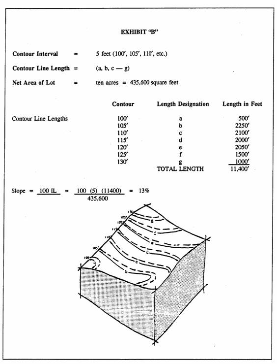
45.03-3 Average slope shall be based on existing contours as shown on aerial maps on file in the office of the City Engineer dated April 1964. Where slope cannot be directly determined by observation, the average slope will be determined by the formula:
Where: I is the contour interval in feet;
L is the combined length of the contour lines in scale feet; and
A is the net area of the lot in square feet.
Exhibit "B" is an example of the use of this formula.
45.03-4 The maximum number of dwelling units permitted in a subdivision shall be determined by dividing the gross land area by the average land area per dwelling unit, computed to the third significant figure, and then rounded to the nearest whole number.
45.03-5 Reduction of Density. The City may require a reduction in the number of dwelling units below the maximum otherwise permitted under this Section if the City determines that such reduction is necessary or appropriate by reason of site restrictions or geologic hazards.
45.03-6 Further Subdivision Prohibited. Upon recordation of a final subdivision or parcel map covering any site zoned "R1-H," no lots or parcels shown on such map may be thereafter further subdivided so as to increase the total density permitted under this Section for the entire subdivision or parcel depicted on the final map.
45.03-7 Exempted Lots. Any lot shown as a unit on a recorded subdivision or land division, or any lot otherwise legally created, is exempt from the density requirements set forth in this Section provided such lot was created prior to the effective date of the ordinance codified in this chapter. Any lot so exempted will not lose its exempt status if either of the following events takes place subsequent to the effective date of the ordinance codified in this chapter:
(a)
A portion of the lot is exchanged for a portion of any adjoining lot, the result of which does not decrease the original square footage of the lot; or
(b)
The lot is enlarged by the addition of land from any adjoining parcel.
Under no circumstances shall the number of dwelling units be greater than the number permitted prior to any modification for lot line adjustment.
45.03-8 Density Exception. Notwithstanding the density provisions of the "H" District set forth in Section XI-10-45.03, a commercial development which was approved prior to the October 15, 1992 effective date of the ordinance codified in this section may, upon site and architectural approval, pursuant to Section XI-10-45.03, be replaced with one less intensive single-family residential dwelling that complies with all other conditions of Section 45 and all other relevant provisions of the Municipal Code.
(Ord. 38.732, 10/7/97; Ord. 38.672 (part), 9/15/92)
XI-10-45.04 - Height Regulations
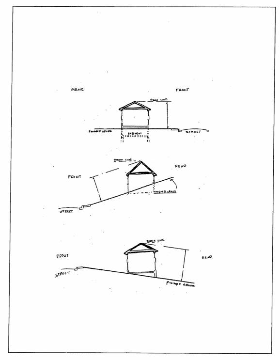
45.04-1 Under no circumstances shall any main building on the west side of the crestline exceed a height of seventeen (17) feet and one (1) story (excluding basements) from the lowest finished grade to the highest ridgeline of the building.
45.04-2 Under no circumstances shall any main building on the east side of the crestline exceed a height of twenty-seven (27) feet and two (2) stories from the lowest finished grade to the highest ridgeline of the building.
45.04-3 Accessory structure(s) shall not exceed seventeen (17) feet and one (1) story from the lowest finished grade to the highest ridgeline of the building anywhere in the hillside.
(Ord. 38.672 (part), 9/15/92)
XI-10-45.05 - Yard Requirements
For lands in the R1 residential zoning district, the following requirements shall apply:
45.05-1 All dwellings shall have a minimum side yard of forty (40) feet.
45.05-2 Minimum front yard setbacks shall be twenty-five (25) feet when the average slope of the lot is less than sixteen (16) percent, or when the front yard slope does not exceed sixteen (16) percent; otherwise, the minimum front yard setback shall be forty (40) feet.
45.05-3 The minimum rear yard setback for the principal dwelling shall be forty (40) feet.
(Ord. 38.672 (part), 9/15/92)
XI-10-45.06 - Crestline Zone of Protection
45.06-1 The purpose of the crestline zone of protection is to preserve the natural quality of the crestline and the slopes immediately below, when viewed from the valley floor.
45.06-2 The crestline zone of protection is defined as the area westerly of the perceived crestline and between the perceived crestline and an elevation one hundred (100) feet below. In the area within three hundred (300) feet easterly of the crestline, structure heights shall be restricted so that no structure extends above the crestline site line.
45.06-3 The perceived crestline is the crestline identified when viewed from the three (3) closest viewpoints of those nine (9) shown on the zoning map and designated as "VP."
45.06-4 The land within the crestline zone of protection shall remain in a natural condition and structures, grading and non-native plant materials are prohibited. All fences constructed within the crestline zone of protection shall be subject to review and approval by the Planning Commission.
45.06-5 In demonstrating compliance with the crestline zone of protection, an applicant shall submit cross-sections from each of the three (3) closest viewpoints from their site. Each cross-section shall include the viewpoint, any proposed structure(s) on the applicant's site, the perceived crestline, and the lower edge of the zone of protection. Each cross-section shall be drawn commencing from the closest viewpoint with lines projecting through the highest point of any and all structures. No structure may visually intrude into the "crestline zone of protection" area. Exception may be granted where development would not be visible from the three (3) closest viewpoints.
(Ord. 38.672 (part), 9/15/92)
XI-10-45.07 - Special Provisions for PUD's in Hillside
45.07-1 When land in Hillside is to be subdivided and is also approved as a PUD, the following rules shall apply in addition to those specified elsewhere in this chapter for PUD's.
45.07-2 There shall be no minimum lot size requirements for PUD's. Clustering of development for PUD's is encouraged and shall be located on not more than ten (10) percent of the total lot area that exists prior to any subdivision.
45.07-3 Land included in a PUD but not included in lots shall be held in common and shall be encumbered with an open space easement in favor of the City unless such common ownership and easement would be inconsistent with approved uses such as public streets or public utilities.
(Ord. 38.672 (part), 9/15/92)
XI-10-45.08 - Open Space Easements
45.08-1 In any subdivision which is not approved as a PUD, at least fifty (50) percent of the gross area within the subdivision shall be encumbered with an open space easement in favor of the City. Side yard and front yard setback areas will not be allowed to be a part of nor encroach on the open space easement. Said easement shall be identified at the time of submittal of the tentative map.
45.08-2 Reconfiguration of the open space easement may be granted, at a public hearing, by the City Council provided that the area (net acreage) is not decreased.
45.08-3 No open space easement dedicated to the City within the "H" Hillside Combining District shall be abandoned by resolution of the City Council without a majority of those voting on the matter in a City election approving of such abandonment. The election shall be held at one (1) of the regularly scheduled election dates for general law cities.
(Ord. 38.672 (part), 9/15/92)
XI-10-45.09 - Site and Architectural Approval
45.09-1 Purpose. It is the policy of the City to review the proposed construction or expansion of single-family dwellings and certain accessory structures under circumstances where such structures might constitute an invasion of privacy, unreasonable interference with views, light and air, and create adverse impacts upon the aesthetic character of neighboring residential structures. The purpose of this Section is to establish standards and procedures to be followed with respect to the design review of single-family dwellings and certain accessory structures to ensure that new development occurs in a manner which is consistent with the objectives of this Chapter and the policies of the General Plan.
45.09-2 Applicability-Requirement for Site and Architectural Review. In each of the following cases, no building permit shall be issued for the construction or expansion of a single-family structure or accessory structure in any "H" District, until such structure has received a site and architectural review approval by the Planning Commission and City Council pursuant to this Section:
(a)
Prior to any grading;
(b)
Prior to construction of any new structure; or
(c)
Prior to any modification that requires a building permit, any interior alteration, or any alteration or conversion where such alteration or conversion does not result in any exterior modifications to the existing structure beyond the installation of skylights in the roof, installation of new windows or doors, fireplaces or chimneys, or any other minor alteration which in the opinion of the Community Development Manager meets the intent of this Subsection.
45.09-3 Application Requirements-Public Hearing. Site plan and building elevations, which portray as accurately as possible the ultimate development of the lot, shall be submitted to the City. The plans shall include all structures, grading, landscaping, colors and materials.
45.09-4 The applicant shall in addition propose a "building envelope" within which all development other than specified minor improvements such as fences (permitted by Section XI-10-45.13, Fences) and driveways shall be located.
45.09-5 A public hearing on the site and architectural review application shall be required at the planning commission level only. The review before the city council shall not be a public hearing. Provided, however, that any modifications or addition onto an existing structure, on parcels twenty thousand (20,000) square feet or less, shall not require a review by either the Planning Commission or City Council but said modifications or addition must comply with the site and architectural guidelines contained in this Section.
45.09-6 Application Materials. Application for site and architectural review ("S" Zone Approval) shall be made, with the Community Development Department, on a form prescribed for this purpose.
The application shall include the following exhibits such as, but not limited to:
Site plan
Building envelope and open space plan
Existing topographic plan
Architectural plan(s)
Roof plan
Floor plan(s)
Line of sight-view restriction/obstruction analysis
Landscape plan
Crestline zone of protection plan, where appropriate
Grading plan
The application shall be accompanied by the payment of a processing fee(s), in such amount(s) as established by the City Council.
45.09-7 Site and Architectural Guidelines. The Planning Commission and City Council shall consider the following guidelines in its review process:
(a)
Avoid Unreasonable Interference with Views and Privacy. The height, elevations and placement on the site of the proposed main or accessory structure, when considered with reference to the nature and location of residential structures on adjacent lots, will avoid unreasonable interference with views and privacy.
(b)
Preserve Natural Landscape. The natural landscape will be preserved insofar as practicable by designing structures to follow the natural contours of the site and minimizing tree and soil removal.
(c)
Minimize Perception of Excessive Bulk. The design of the proposed main and/or accessory structure(s) in relation to the immediate neighborhood should minimize the perception of excessive bulk.
(d)
Impairment of Light and Air. The proposed main or accessory structure(s) shall not unreasonably impair the light and air of adjacent properties nor unreasonably impair the ability of adjacent properties to utilize solar energy.
(e)
Grading. All grading shall be kept to an absolute minimum and shall comply with the grading ordinance criteria.
(Ord. 38.672 (part), 9/15/92)
XI-10-45.10 - Slope Planting
The face of all cut-and-fill slopes may be required to be planted and maintained with a ground cover as recommended by the geotechnical report in order to protect the slopes against erosion as soon as practical and prior to the final approval of the grading. This plant material shall be shown on the landscape plan.
(Ord. 38.672 (part), 9/15/92)
XI-10-45.11 - Residential Driveways and Parking
45.11-1 Privately owned and maintained access from the public road to each single-family dwelling shall be a minimum of fourteen (14) feet in width. Turning radius shall be designed to meet the Fire Department's requirements.
45.11-2 Turnout space shall be provided on driveways over one hundred fifty (150) feet in length with a maximum spacing of one hundred fifty (150) feet if driveway is less than eighteen (18) feet wide.
45.11-3 Turnaround. All dwelling units shall provide an on-site area for vehicles to turn around if served by a driveway over one hundred fifty (150) feet in length to meet Fire Department's requirements.
45.11-4 Vertical Clearance. All privately owned and maintained roads and drives shall assure a minimum fourteen (14) foot vertical clearance.
45.11-5 There shall be provided at the time of erection of any dwelling at least two (2) permanently maintained parking spaces on the same lot with the dwelling, for each dwelling unit. Said parking spaces shall be not less than ten (10) feet wide and twenty (20) feet long with adequate provisions for ingress and egress.
45.11-6 Private parking may be required to be located to the rear of the front setback line. Criteria used to determine need for parking to be located behind the front setback line shall be based on providing safe access which is harmonious with adjacent natural land slope, and structures existing and proposed.
45.11-7 The design of the driveway and parking areas shall consist of an all-weather surface conforming to Section II-13-18, Paving Standards, and Section XI-10-54.03, Improvement of: Parking Areas, Auto Sales Areas and Loading Areas, of this Code.
45.11-8 The Planning Commission and City Council may grant exceptions to the above requirements pursuant to the guidelines set forth in Subsection 45.09-7, Site and Architectural Guidelines, of this Section.
(Ord. 38.672 (part), 9/15/92)
XI-10-45.12 - Non-Residential Off-Street Parking
Off-street parking shall be provided on-site for all nonresidential uses. The number and design of parking spaces shall be in accordance with Section XI-10-53, Off-Street Parking Regulations, and Section XI-10-54.03, Improvement of: Parking Areas, Auto Sales Areas and Loading Areas.
(Ord. 38.672 (part), 9/15/92)
XI-10-45.13 - Fencing
Fencing on hillside lots shall be minimized and shall be of an open variety, except fencing around the immediate vicinity of each house. Fencing criteria will be found in Section XI-10-54.11, Fences.
(Ord. 38.672 (part), 9/15/92)
XI-10-45.14 - Recreation Courts
45.14-1 Grading for tennis courts and other recreation courts shall not exceed six (6) feet of fill or twelve (12) feet of cut and fill. A site development application for a tennis or other recreation court which proposes grading in excess of the limits of this Chapter may be approved by the City upon finding that the excess cut or fill:
(a)
Will not result in slopes prone to landslides or soil creep;
(b)
Can be landscaped and/or contours rounded to render the cut or fill inconspicuous when viewed from off the site; and
(c)
Can be properly drained according to methods approved by the Building Division.
45.14-2 Screening. Recreation courts shall be landscaped and screened so as to be unobtrusive from off-site. The structure will not be permitted unless this screening can be accomplished without interfering with the function of the structure.
45.14-3 Color. All surface and retaining walls shall be colored in natural tones and screened as appropriate so that the court is not conspicuous when viewed from off-site.
(Ord. 38.672 (part), 9/15/92)
XI-10-45.15 - Outdoor Lighting.
45.15-1 Tennis—Recreation Courts. No artificial lighting shall be permitted for tennis and other recreation courts.
45.15-2 Swimming Pools and Spas. Artificial lighting of swimming pools and spas shall be permitted only under the following conditions:
(a)
Light(s) are placed beneath the surface of water in the pool or spa to illuminate the water;
(b)
Other exterior lights used to illuminate the surrounding area;
(c)
Light(s) use the minimum wattage which will safely illuminate the area;
(d)
No direct light is cast beyond the immediate area of the pool or spa; and
(e)
No light sources are directly visible from off the site.
45.15-3 Outdoor Lighting-General. Outdoor lighting should use the minimum wattage lights which will safely illuminate the area. Outdoor light sources shall be shielded so as not to be directly visible from off-site. This section does not pertain to motion-induced/activated or motion-sensor security-type lights.
(Ord. 38.672 (part), 9/15/92)
XI-10-45.16 - Underfloor Clearance
All new single-family main structures and accessory buildings, or additions thereto, shall be designed to follow the slope of the site so as to reduce the clearance between ground-floor levels and finish grade to not more than five (5) feet. This underfloor clearance shall not be enclosed. The Planning Commission and City Council may grant exceptions to this requirement pursuant to the guidelines set forth in Subsection 45.09-7 of this Section.
(Ord. 38.672 (part), 9/15/92)
XI-10-45.17 - Maximum Size of Residence, Accessory Structures, and Impervious Surface Coverage
45.17-1 Purpose and Intent. The purpose and intent of limiting the amount of impervious surface coverage allows for the site and area to remain in its natural setting, as much as possible, without incorporating unnatural man-made features. Impervious surfaces also increase stormwater runoff, which is to be considered in the design of drainage systems.
45.17-2 Definition. "Impervious surfaces" are meant to include surfaces that will not allow or will greatly reduce the penetration of water into the ground. Impervious surfaces include the following: concrete, asphalt, bricks, paving stones, swimming pools, "turf stones," plastic sheeting, compacted gravel and rock areas, and similar surfaces. Impervious surfaces shall also include any and/or accessory structures located on a specific site.
45.17-3 On parcels less than three (3) acres, the amount of impervious surface on the site is limited to eight thousand (8,000) square feet or ten (10) percent of the total lot area, whichever is greater (including the building footprint). The maximum size of the main residence shall not exceed six thousand (6,000) square feet.
45.17-4 On parcels three (3) acres or greater, the amount of impervious surface on the site is limited to ten (10) percent of the total lot area (including the building footprint). Under no circumstances shall the impervious surface coverage exceed thirty thousand (30,000) square feet. The maximum size of the main residence shall not exceed ten thousand (10,000) square feet.
45.17-5 The maximum size of an accessory structure shall not exceed one thousand two hundred (1,200) square feet.
(Ord. 38.672 (part), 9/15/92)
XI-10-45.18 - Grading Requirements
45.18-1 Purpose and Intent. The intent of this Section is to regulate use, development and alteration of land in hill areas so that essential natural characteristics such as land form, vegetation and wildlife communities, scenic qualities, and open space can substantially be maintained; to preserve unique and significant geologic, biologic and hydrologic features of public value; to encourage alternative approaches to conventional hillside construction practices by achieving land use patterns and intensities that are consistent with the natural characteristics of hill areas such as slope land form, vegetation and scenic quality. It is further the intent of this Chapter to protect predominant views of and from hill areas in order to maintain the identity, image and environmental quality of the City; and to achieve land use densities that are in keeping with the General Plan.
45.18-2 Definition. "Grading" means an excavation or fill, or the stockpiling or any combination thereof, or the conditions resulting from any excavation or fill. All grading quantities shall be measured in their compacted state.
45.18-3 Design Standards and Requirements.
(a)
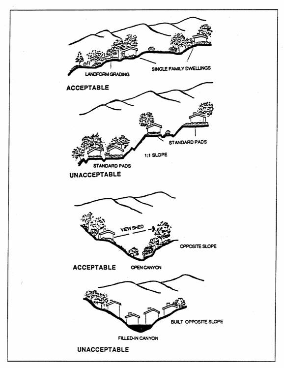
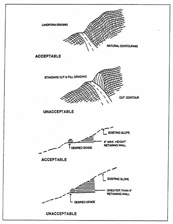
Grading will "blend" in with the natural land forms and native vegetation to the maximum extent feasible.
(b)
No grading cut or embankment with a slope greater than three (3) feet horizontal to one (1) foot vertical shall be located adjacent to a publicly maintained right-of-way. The applicant shall provide suitable guarantees, satisfactory to the Planning Commission, for landscaping and perpetual maintenance, at no cost to the City, of all slopes greater than fifteen (15) feet in total elevation.
(c)
Within six (6) months, or such other period established by the Planning Commission, after the commencement of grading activities, all graded areas not covered by an impervious surface shall be stabilized in such manner as shall be approved by the Community Development Manager.
(d)
Landscaping coverage and stabilization of graded slopes shall be selected and designed to be compatible with surrounding natural vegetation or to replace removed natural vegetation and should recognize climatic, soil and ecologic characteristics of the region. Plant materials that require excessive water after becoming established should be avoided. (Refer to illustrations.)
(e)
Trees which have a six (6) inch or greater diameter trunk size at a point three (3) feet above grade should not be removed. The location of all such trees shall be shown on all plans submitted for approval. The Planning Commission, upon review of an "S" Zone application approval, shall have the power to authorize removal, relocation or replacement if the applicant can show that such requirement is unreasonable as applied to the particular property. If the removal is permitted, the replacement of any trees removed pursuant to this Section shall be at a five to one (5:1) ratio.
(f)
The overall shape, height, grade or any cut-or-fill slopes shall be developed in concert with existing natural contours and scale of the natural terrain of a particular site. (Refer to illustrations.)
(g)
Where two cut-or-fill slopes intersect, the intersection shall be horizontally rounded and blended. (Refer to illustrations.)
(h)
Where any cut-or-fill slopes intersect the natural grade, the intersection of each slope shall be vertically and/or horizontally rounded and blended with the natural contours so as to present a natural slope appearance. (Refer to illustrations.)
(i)
Provide sites which fit into the terrain and allow for minimal amount of grading. Grading of any area of a site with a natural slope greater than forty (40) percent shall be prohibited.
(j)
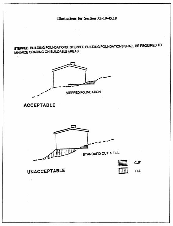
Stepped building foundations shall be required to minimize grading on building pads. (Refer to illustrations.)
(k)
Streets shall be designed to generally follow the natural contours and land form in order to minimize cut and fill. Exposed walls and fences facing roadways and retaining walls shall be no greater than six (6) feet in height. Crib walls fencing roadways shall be no greater than fifteen (15) feet in height. (Refer to illustrations.)
(l)
Structures shall be designed to fit with the contours of the hillside and relate to overall form of the terrain. Structures shall be designed to fit into the hillside rather than altering the hillside to fit the structure. (Refer to illustrations.)
45.18-4 Development Plan Review Procedures. To further the specific purposes of this chapter, the following procedures are established:
(a)
Development Plan With Grading Under Five Hundred (500) Cubic Yards. Where the aggregate volume of grading on any site or contiguous group of sites is under five hundred (500) cubic yards, the Community Development Manager shall review the proposed Grading Plan. If the plan is found to be in conformance with the provisions of this chapter, the Grading Plan shall be approved. In approving the plan, such conditions as are reasonably necessary to ensure compliance with the objectives of the chapter may be imposed.
(b)
Development Plan With Grading in Excess of Five Hundred (500) Cubic Yards. Where the aggregate volume of grading exceeds five hundred (500) cubic yards but is under one thousand five hundred (1,500) cubic yards, the Planning Commission shall review the proposed Grading Plan. If the plan is found to be in conformance with the provisions of the chapter, the Grading Plan shall be approved. In approving the plan, such conditions as are reasonably necessary to ensure compliance with the objectives of this chapter may be imposed. On receipt of the recommendations of the Planning staff, the Planning Commission shall approve or deny the application.
(c)
Development Plan With Grading in Excess of One Thousand Five Hundred (1,500) Cubic Yards. Where the aggregate volume of grading exceeds one thousand five hundred (1,500) cubic yards, the Planning Commission shall review the proposed Grading Plan and recommend approval or denial to the City Council. If approval is recommended, such conditions as are reasonably necessary to secure substantially the objective of this chapter may be included. On receipt of the recommendations of the Planning Commission, the City Council shall approve or deny the application.
45.18-5 Grading Plan Requirements. Wherever proposed grading in the hillsides exceeds five hundred (500) cubic yards, the applicant shall submit grading plans prepared by a licensed Civil Engineer. Said grading plans shall include, but not be limited to, the following:
(a)
Property lines and accurate contours of existing and proposed elevations;
(b)
Cross-sections taken through at least two (2) planes normal to each other. Horizontal and vertical depictions shall be made in the same scale;
(c)
Quantities of fill and excavating proposed in cubic yards;
(d)
Location of all existing and proposed structures; and
(e)
Location of existing trees which have a six (6) inch or greater trunk diameter at a point three (3) feet above grade, and details of the measures proposed to conserve such trees.
(Ord. 38.672 (part), 9/15/92)