
Milton City Zoning Code
ARTICLE 15
- RIGHT-OF-WAY AND ACCESS STANDARDS
15.1 - BLOCKS
A.
Block Length.
(1)
Residential blocks shall not exceed 1,000 feet in length, unless approved by the City Council. Shorter block length is desirable.
(2)
Where blocks are 900 feet or more in length City Council shall require a 20-foot pedestrian easement which bisects the block.
B.
Block Design.
(1)
The shape of a new block must be generally rectangular, but should vary to conform to natural features, highway and rail rights-of-way, park boundaries, or site constraints.
a.
Where blocks curve, they must generally maintain their cardinal orientation over their entire trajectory.
b.
Additionally block shape shall be determined with regard to the following:
i.
The provision of building sites of adequate size and shape dependent upon the type of use being contemplated; and
ii.
The zoning requirements of the development site; and
iii.
The need for convenient access, circulation, control, and safety of street traffic; and
iv.
The limitation of the topography and natural features; and
v.
Should be oriented for drainage.
(2)
Blocks shall be wide enough to allow for two tiers of lots (i.e., two lots deep).
(Ord. No. 1992-23, § I, 10-10-2023)
15.2 - GENERAL RIGHT-OF-WAY STANDARDS
All new construction, reconstruction, and reconfiguration of rights-of-way must comply with this section. This does not apply to limited access expressways. Rights-of-way must be designed in relation to topographic and drainage conditions, public safety, and the development served by the right-of-way.
A.
Right-of-Way Construction.
(1)
All public and private rights-of-way should be improved as complete streets.
a.
The City reserves the right to require that all new development involving the platting of land or private drives meet the complete street standards found herein.
b.
A complete street is defined as right-of-way facilities that are designed and operated to enable safe access for all users. Persons with disabilities, pedestrians, bicyclists, motorists, and transit riders are able to safely move along and across a right-of-way designed as a complete street.
(2)
New rights-of-way shall connect to and extend the existing block network where possible. This requirement does not apply when connections cannot be made because of a natural or man-made barrier, such as existing structures, existing subdivisions, steep slopes, wetlands and waterbodies, railroad and utility rights-of-way, and parks and dedicated open space.
(3)
All rights-of-way construction and repair must be in accordance with standards and specifications set forth by the City Engineer or City Public Works.
(4)
Vertical alignment must be in accordance with standards and specifications set forth by the City Engineer or City Public Works.
(5)
Horizontal alignment must be in accordance with standards and specifications set forth by the City Engineer of City Public Works.
(6)
Unless approved by the City Engineer or City Public Works, all streets must have a centerline tangent of 100 feet between reversed curves.
(7)
Street grades must conform in general to the terrain. The minimum grade will be based on the surface type of the roadway as determined by the City Engineer or City Public Works.
a.
Street grades should not be less than 3/10 of 1% nor more than 5% for major street and collector streets and not less than 3/10 of 1% nor more than 10% for minor streets unless steeper grades are permitted by the City Engineer or City Public Works.
B.
Intersection Requirements.
(1)
Street intersections should be designed as close to right angles as possible. If, because of topography or other natural or manmade barriers, an intersection cannot be at right angles, the intersection may use an alternate design that ensures safety.
a.
No Street shall intersect any other street at less than 70 degrees.
(2)
Street jogs with centerline offsets of less than 100 feet shall be avoided except where the intersected street has a divided roadway without a median break at either intersection.
(3)
These minimums may be increased where the City Engineer or City Public Works finds that larger arcs or radii are necessary for the proper design of the intersection.
C.
Property Line and Curb Radius.
(1)
Curb radii cannot be less than 25 feet.
a.
Curb radii must be increased proportionately where the angle of intersection decreases.
(2)
Property lines at street intersections shall be rounded with a radius of 35 feet or greater where deemed necessary by the development approval authority.
D.
Clearing and Grubbing.
(1)
The entire area indicated for public use must be cleared and grubbed as directed by the City Engineer or City Public Works.
a.
In the areas designated to be cleared and grubbed, all stumps, roots, brush, and other unsatisfactory materials must be removed to a minimum depth of two feet below the subgrade, then backfilled and compacted with suitable material.
E.
Drainage.
(1)
Proper drainage is the responsibility of the sub-divider and shall comply with Article 13;
(2)
The type of drainage system (e.g. subsurface, open ditch, inverted crown, etc.) and its design must be approved by the City Engineer or City Public Works;
(3)
Easement along lot lines shall be provided for drainage where necessary and shall be at least 20 feet wide; and
(4)
Alternative infrastructure designs are encouraged.
F.
Utility Installation.
(1)
Prior to paving of streets or sidewalks, water and sewer mains and services must be in place, or the developer must provide necessary casing for utilities.
(2)
No pavement may be cut without the approval of the City Engineer or City Public Works.
(3)
No boring of new pavement is allowed for the installation of new service line mains or other facilities unless approved by the City Engineer or City Public Works.
G.
Street Lighting.
(1)
Prior to approval of a final plat, a plan for the installation of streetlights on all new streets must be approved. The street lighting plan must include the type, location, and mounting of all fixtures and poles, and evidence that the system must be designed to yield, at 80% efficiency, a minimum of 0.2 foot-candles at the centerline of the street with a uniformity ratio of four to one (average to minimum).
(Ord. No. 1992-23, § I, 10-10-2023)
15.3 - RIGHT-OF-WAY DIMENSIONS
(1)
All rights-of-way shall match one of the right-of-way types of this section, which may be modified as needed by the City Engineer or City Public Works to address specific site conditions.
(2)
Specific design features such as bike lanes and sidewalks may not be required on both sides of the right-of-way if the minimum right-of-way widths for the various street types, as required in the Comprehensive Plan, has been achieved or surpassed.
a.
Minimum Arterial Right-of-Way width: 100 feet.
b.
Minimum Collector and Local Roadway widths are 60 feet.
A.
Right-of-Way Types. The classifications of rights-of-way are divided into the following:
(1)
Primary Classifications.
a.
Arterial roadways, also known as Major Streets, carry the majority of trips entering and leaving the Planning Area, as well as the majority of through movements.
b.
Collector roadways provide both access to and traffic circulation within residential neighborhoods and commercial areas. Collector streets differ from major streets in that collector streets enter residential neighborhoods, distributing trips from arterials through the area to destinations. Collector streets also collect traffic from local streets in residential neighborhoods and channel into the arterial system.
c.
Local roadways, also known as Minor streets, primarily provide direct access to abutting land and access to the higher order street.
(2)
Secondary Classifications.
a.
A Frontage road is a secondary road running parallel to a major street or highway that provides access to houses and businesses.
b.
Alleys are a vehicular drive located to the rear of lots providing access to service areas, parking, and outbuildings, and often containing utility easements.
B.
Right-of-Way Dimensional Requirements. Minimum dimensions are provided for each right-of-way type. The illustrative examples are also provided to demonstrate a potential configuration of a right-of-way type. Variations to these configurations may be approved by the City Engineer or City Public Works. All dimensions indicated are minimums for the particular type of right-of-way, unless otherwise indicated.
C.
Right-of-Way Design Requirements. Figures 15.3.1 through 15.3.8: Right-of-Way Types, provides right-of-way dimensions. Rights-of-way must be designed and constructed in accordance with the standards of this Article.
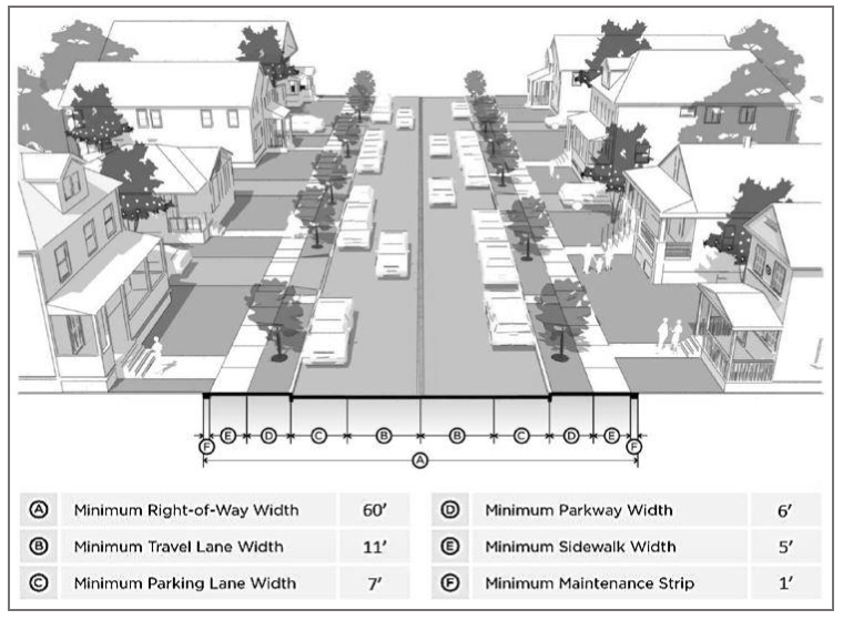
Figure 15.3.1. Minor Street: Neighborhood Two Lane
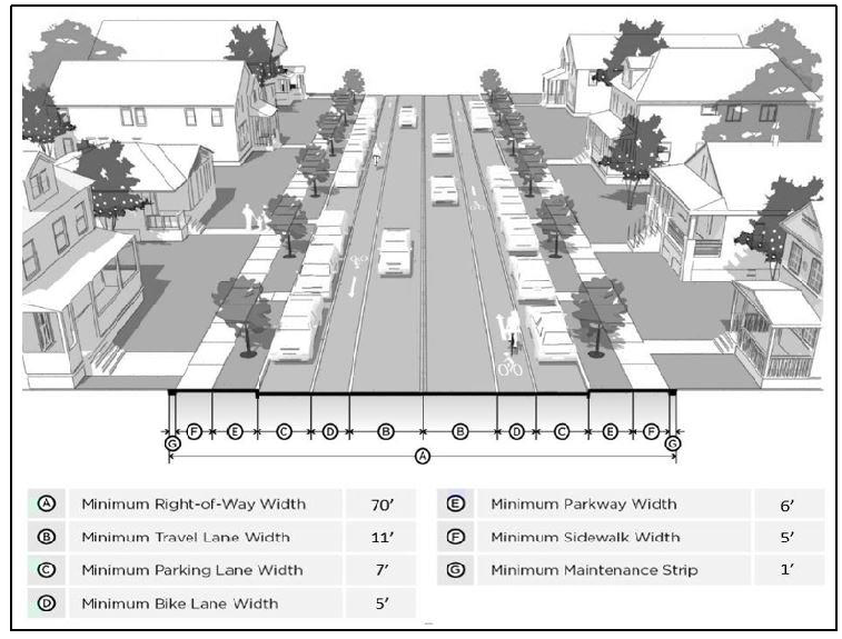
Figure 15.3.2. Minor Street: Neighborhood Two Lane with Bicycle Lanes
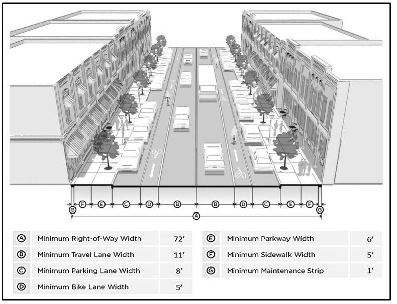
Figure 15.3.3. Collector Roadway: Two Lane—Undivided
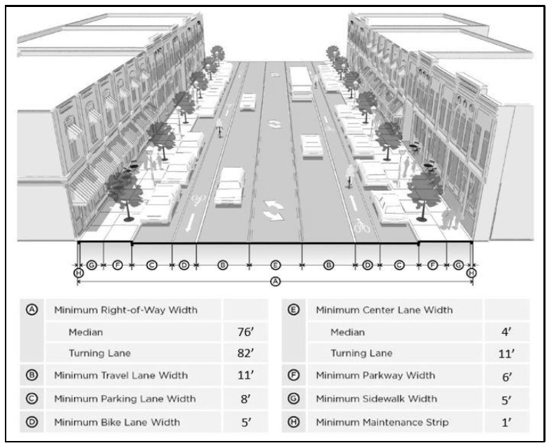
Figure 15.3.4. Collector Roadway: Two Lane—Divided
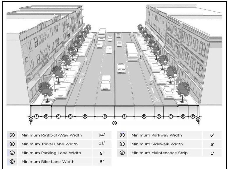
Figure 15.3.5. Collector Roadway: Four Lane—Undivided
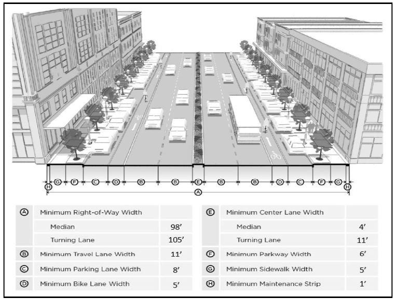
Figure 15.3.6. Arterial Roadway: Four Lane—Divided
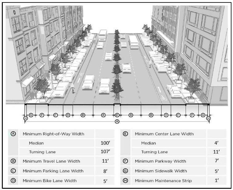
Figure 15.3.7. Arterial Roadway: Four Lane—Divided
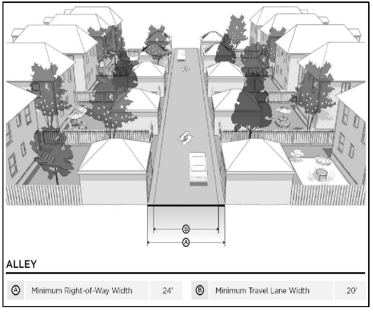
Figure 15.3.8. Secondary Class: Alley
(Ord. No. 1992-23, § I, 10-10-2023)
15.4 - ACCESS MANAGEMENT STANDARDS
All proposed developments shall conform to the guidelines in 15.4(A) for vehicular access to the greatest extent possible without denying reasonable access to any proposed development. The following standards shall determine the character and number of access points to be allowed unless the development approval authority determines that unmitigated conditions exist. Nothing in this section shall be construed to prohibit development access to a public right-of-way.
A.
Development on the State Highway System. Proposed development requesting direct access to an arterial or collector roadway on the state highway system must apply for a driveway permit from the state department of transportation (FDOT) in accordance with F.A.C. Ch. 14-96, State Highway System Connection Permits. FDOT conceptual approval for the driveway must be granted prior to final approval of the development plan by the city. The following minimum distances between driveway connections, median openings and traffic signals shall apply. However, it is not the city's intent to prohibit a duly warranted traffic signal which is required to mitigate safety and access problems.
Table 15.4.1. Minimum Distances between Driveway Connections, Median Openings, and Traffic Signals
* The 35 mph or less (special case) standards shall be used only where current connection development averages at least 50 connections per mile on the side of the highway for which the connection is required, based on actual count of connections one-fourth mile in each direction (total one-half mile) from the proposed connection.
B.
Commercial Corridor Standards. Highways 87, 89, and 90, also known as Stewart St., Dogwood Dr. and Caroline St., respectively, are considered Arterial Roadways, and the City's major commercial corridors. As such, non-residential development on parcels which abut these roadways shall be improved in accordance with the following, in addition to all other applicable standards of this Code.
(1)
Street standards.
a.
Arterial roadways shall be of a 45-mph design speed.
(2)
Utility standards.
a.
Underground utilities are required for all street frontages.
i.
Where the enforcement of the provisions of this section would result in undue hardship on the part of a utility, sub-divider or developer, application for exception from the provisions herein may be made in the following manner.
ii.
Upon written application, an exception may be granted by the Board of Adjustments in cases where the installation of underground utilities would present a unique hardship.
1)
Conditions imposed by the Planning Board or by the City Council are excluded from this appeal process.
iii.
Written application shall be filed with the Planning and Development Department, with a copy to the City Engineer;
iv.
Such written application shall include all information, facts and figures necessary to properly advise and inform the Director of Planning and Development and the City Engineer of the circumstances which require such appeal and which create the hardship;
(3)
Connectivity standards.
a.
Within all developments, the following standards shall apply unless a variance is sought and obtained from the Board of Adjustments due to unusual topography or environmental constraints that create a severe and unique hardship:
i.
Continuous pedestrian walkways shall be provided to connect building entrances to required sidewalks along street frontages.
b.
The utilization and provision of connections to and from adjacent developments and developable parcels shall be required.
i.
All development plans shall incorporate and continue all cross access or stubs to the boundary of the development plan by previously approved development plans or existing development.
c.
All development plans shall provide for future public connections to adjacent developable parcels by providing a connection spaced at intervals not to exceed 200 feet along each development plan boundary that abuts potentially developable or re-developable land.
d.
Multimodal access shall be provided or constructed for a commercial or multifamily residential development that abuts another commercial or multifamily residential development, whether existing or planned. The development of the site shall incorporate the following:
i.
Continuous access where necessary to connect adjacent parcels along the thoroughfare.
ii.
Driveway aprons, stub-outs, and other design features to indicate that abutting properties may be connected to provide cross access.
iii.
New commercial or multifamily property that abuts a planned, new or existing multifamily residential property shall provide for a minimum five-foot wide sidewalk connecting the two uses.
C.
Cross-Access.
(1)
Joint Use Driveways.
a.
Adjacent uses may share a common driveway; provided that appropriate access easements are granted between or among the property owners.
b.
The use of joint driveways may be required by the development approval authority when feasible and when necessary to meet the provisions of this article.
(2)
Adjacent non-residential uses, including mixed-use development, with dedicated parking areas are encouraged to provide a cross-access drive to allow circulation between sites. Property owners are encouraged to pursue cross-access with adjacent property owners at the time of development.
(3)
Joint Use Driveways and Cross-Access easements must incorporate the following:
a.
Bump-outs and other site design features to make it visually obvious that the abutting properties are tied together.
b.
A unified access and circulation plan for shared parking areas.
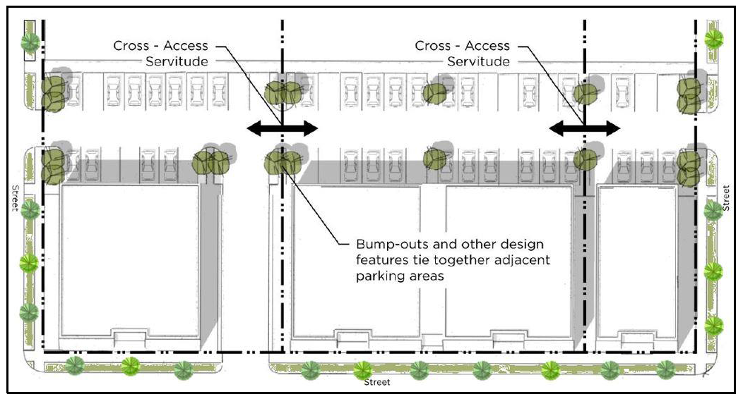
Figure 15.4.1. Cross-Access Easement/Servitude Diagram
(4)
Pursuant to this section, property owners who establish cross-access easements must:
a.
Record an Easement allowing cross-access to and from properties served by the joint use driveways and cross-access servitude.
b.
Any pre-existing driveways must be closed and eliminated after construction of the joint-use driveway.
c.
Record a joint maintenance agreement defining the maintenance responsibilities of each property owner.
D.
Deceleration Lanes.
(1)
A major driveway entering a street with a regulated speed greater than 35 miles per hour shall be required to provide a deceleration lane.
(2)
An acceleration or deceleration lane that would begin or end within 75 feet of another driveway or intersecting street shall be lengthened so that it connects with the adjacent street or driveway.
E.
Additional Access Management Standards in Commercial Districts.
(1)
Driveway Connections.
a.
Driveway connections to public streets shall be consistent with the following standards:
i.
Driveway connections shall not be permitted within the controlled access zone of an intersection.
ii.
Out parcels with less than 100 feet of road frontage are restricted to internal access only.
iii.
Driveways that enter a major thoroughfare at traffic signals must have at least two outbound lanes (one for each turning direction) of at least 12 feet in width, and one inbound lane with a minimum width of 12 feet.
iv.
No residentially developed property may have a curb cut in excess of 40 feet in width, and no nonresidential property may have a curb cut in excess of 48 feet without approval of the public works director and fire chief.
v.
Except for single-family and two-family residences, driveway grades shall conform to the requirements of the Florida Department of Transportation Regulations for Driveway and Encroachment Control.
vi.
Except where driveways are on opposite sides of a raised median, driveways on opposite sides of a street shall either directly align or have offsets of a minimum of 100 feet, as measured between the extended centerlines of such driveways.
vii.
Whenever possible, driveways on undivided arterials, collector streets, or local streets should align with driveways (if any) on the opposite side of such street.
viii.
On a divided arterial street that includes a median, driveways should align with median breaks whenever possible. Driveways not meeting this standard shall be limited to right turn access (ingress) and right turn egress only.
(2)
Driveway throat length. The length of a driveway or "throat length" for a commercial or office development shall be designed in accordance with the vehicle storage required for entering and exiting vehicles to prevent vehicles from backing into the flow of traffic on the public street or causing unsafe conflicts with on-site vehicle and pedestrian circulation. The throat lengths specified in the table below are generally acceptable guidelines intended for the major entrance driveway of a commercial development. Alternative designs that meet the safety and circulation needs of vehicular and pedestrian traffic shall be considered by the development approval authority.
Table 15.4.2. Driveway Throat Length for Commercial Centers
F.
Location of Access Points.
(1)
Driveways shall be located at a point along the frontage of the property that will provide acceptable sight distance minimum 25-foot sight triangle, grade, and alignment conditions for motorists using the proposed driveway and the street, and will avoid any unreasonable interference with the free and safe movement of traffic.
(2)
Existing or proposed highway features such as adjacent existing or future land uses, other driveways, median openings, turn lanes, intersections, drainage facilities, traffic signals, pedestrian traffic, and utilities shall be considered in determining the location of driveways.
a.
In the interest of public safety, maintenance of service level, and convenience, the placement of a driveway may be restricted to a particular location along the frontage and sight triangle dimensions may be increased.
(3)
Curb cuts for driveways on single family - attached or detached, and two-family dwelling lots shall be prohibited along arterial streets.
G.
Separation and Number of Access Points/Driveways/Curb Cuts. A minimum number of driveways or street vehicular access points are required per the following table:
Table 15.4.3. Non-Residential Development Access Points
(1)
All curb cuts require approval of the City Engineer or Public Works.
(2)
Single-family, two-family, and semi-detached dwellings are limited to one access point. However, lots of 120 feet or more of street frontage may have two access points to create a circular drive or provide access to the rear and/or side yard only.
(3)
Townhouse and multi-family dwellings are limited to two access points per street frontage.
(4)
Lots for non-residential uses in all districts are limited to two access points per street frontage. Development on lots of 600 feet or more of street frontage, may have one additional access point for each 500 feet of additional frontage. This does not apply to drive-through uses or gas stations.
(5)
The separation between access points onto collector roadways, which are not on the state highway system, or between an access point and an intersection of such a collector roadway with another road, shall be at least 50 feet.
(6)
The distance between access points shall be measured from the centerline of the proposed driveway or roadway to the centerline of the nearest adjacent roadway or driveway.
(7)
Additional driveways and/or design elements may be authorized when an approved traffic engineering study indicates a need for a departure from the above regulations.
H.
On-Site Traffic Circulation. The following guidelines do not apply to single-family, detached or attached and two-family (duplex) residential developments.
(1)
Pedestrian circulation facilities, roadways, driveways, and off-street parking and loading areas shall be designed to be safe and convenient;
(2)
Parking and loading areas, aisles, pedestrian walks, landscaping, and open space areas shall be designed as integral parts of an overall development plan and shall be properly related to existing and proposed buildings;
(3)
Buildings, parking and loading areas, landscaping and open spaces shall be designed so that pedestrians moving from parking areas to buildings and between buildings are not unreasonably exposed to vehicular traffic.
a.
Vehicle drive-thru lanes which separate parking areas from building entrances shall be prohibited unless no other reasonable alternative exists;
(4)
Off-street parking areas shall be physically separated (i.e. by separation strips) from adjacent roadways, as per the landscaping, screening, and sidewalk standards of this Code, except for the access points approved by the development approval authority and/or the state department of transportation (FDOT), as applicable. The county shall have control of the access points on county roads. Applicant/developer shall coordinate county permitting and provide the city with the appropriate county driveway permit.
(Ord. No. 1992-23, § I, 10-10-2023)
15.5 - SIDEWALK DESIGN STANDARDS
A.
Sidewalk Requirements.
(1)
Sidewalks shall be provided on at least one side of all rights-of-way. Sidewalks are not required where one side of the right-of-way is a railroad, or other feature to which the public does not require access.
(2)
Sidewalks must be paved with a permanent, fixed, non-slip material.
(3)
Sidewalks must be as straight and direct as possible.
a.
Where a development has greater than 500 feet of street frontage, a more unique and meandering sidewalk design which incorporates landscaping focal points and other pedestrian features is encouraged.
(4)
Where sidewalks cross driveways, the sidewalk zone must remain level, with no change in cross-slope.
(5)
All sidewalks shall be a minimum of five (5) feet in width unless otherwise required by this Code.
B.
Sidewalk Design Standards in the D-CM Zoning Districts.
(1)
A minimum five (5) foot wide sidewalk shall be required.
a.
If a wider sidewalk is adjacent to the development, the minimum required width shall mimic the existing.
b.
Bulb-outs, street trees, and other features shall occur outside of the required sidewalk space.
c.
Approved Street Lighting may be placed within the required sidewalk space.
(2)
Pedestrian crosswalks shall be provided at all key intersections within the development and shall be clearly designated with decorative paving complimentary to the development and surrounding structures.
(3)
Suspended planter or flower boxes may project up to 18 inches into the required sidewalk space.
(4)
Stoops, stairs and access ramps may not project into the required sidewalk space.
(Ord. No. 1992-23, § I, 10-10-2023)
15.6 - BICYCLE LANE DESIGN STANDARDS
A.
Where bicycles lanes are included in right-of-way construction, reconstruction, and reconfiguration projects, appropriate designs include, but are not limited to, the design types of this section. Where installed, bicycle facilities, shall be constructed in accordance with the applicable Florida Department of Transportation standards and/or the Manual on Uniform Traffic Control (MUTCD) and the Urban Bikeway Design Guide published by the National Association of City Transportation Officials (NACTO).
(1)
Shared: A marking placed in a vehicular travel lane to indicate that a bicyclist may use the full lane. Also called a shared-lane marking.
(2)
Bike Lane: A portion of the roadway that has been designated by striping, signs, and pavement markings for the preferential or exclusive use of bicyclists, typically located adjacent to motor vehicle travel lanes and flowing in the same direction as motor vehicle traffic.
(3)
Buffered Bike Lane: A conventional bicycle lane paired with a designated buffer space separating the bicycle lane from the adjacent motor vehicle travel lane and/or parking lane.
(4)
Contra-Flow Bike Lane: A bicycle lane designed to allow bicyclists to ride in the opposite direction of motor vehicle traffic, typically used to convert a one-way traffic street into a two-way street, one direction being for motor vehicles and bikes, and the other being for bikes only.
(5)
Left-Side Bike Lane: A conventional bike lane placed on the left side of one-way streets or two-way median divided streets.
(6)
Cycle Track: An exclusive bike facility that combines the user experience of a separated path with the on-street infrastructure of a conventional bike lane. A cycle track is physically separated from motor traffic and distinct from the sidewalk.
(7)
Raised Cycle Track: A bicycle facility that is vertically separated from motor vehicle traffic, typically paired with a furnishing zone between the cycle track and motor vehicle travel lane and/or pedestrian area, and allowing for one-way or two-way travel by bicyclists.
(8)
Two-Way Cycle Track: A physically separated cycle track that allows bicycle movement in both directions on one side of the road.
(Ord. No. 1992-23, § I, 10-10-2023)