
Milton City Zoning Code
ARTICLE 5
- ZONING DISTRICTS AND ZONING MAP
5.1 - LEGAL INTERPRETATION OF DISTRICTS AND BOUNDARIES
A.
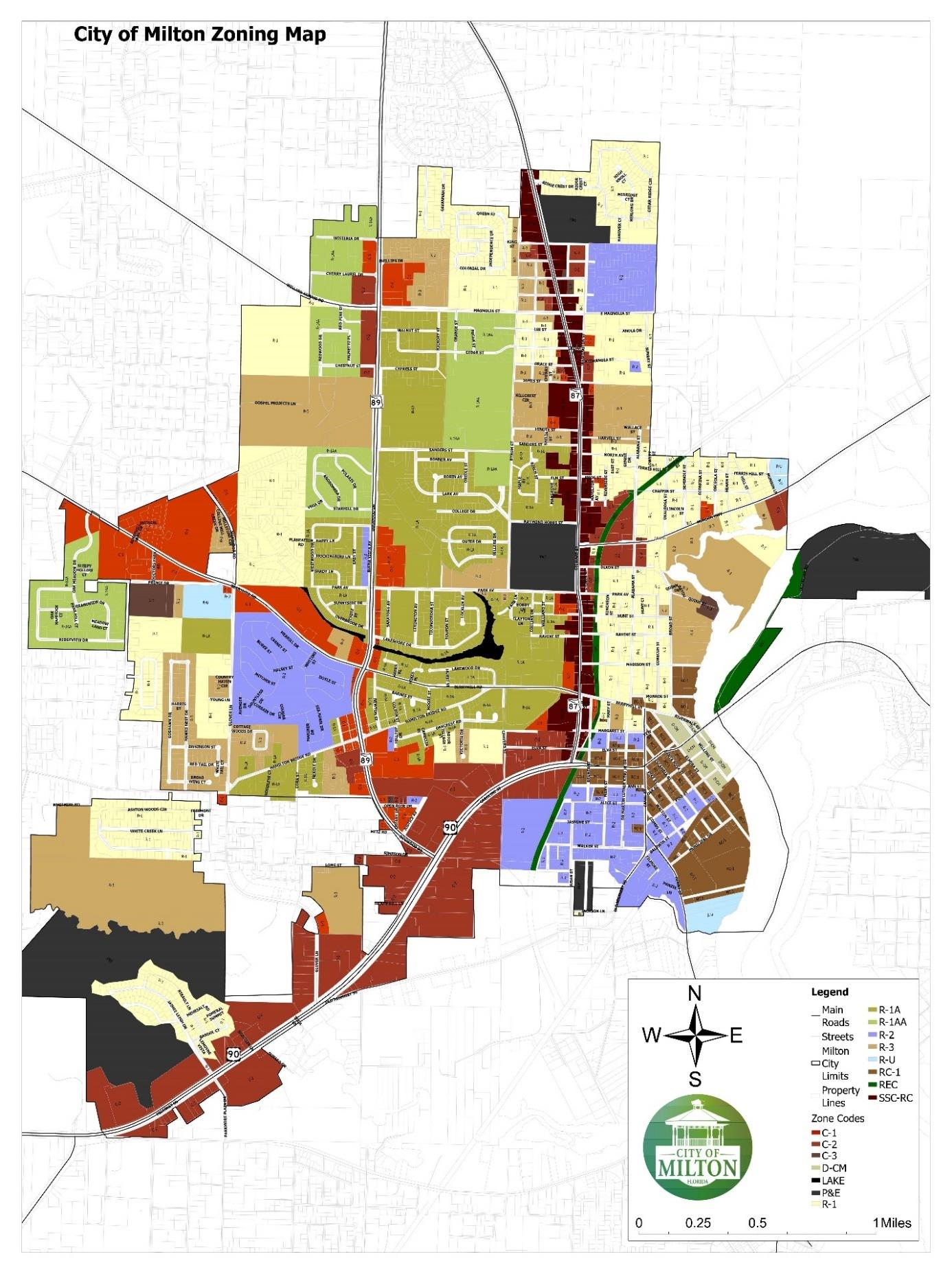
The City of Milton Future Land Use Map, being the date September 1990, in addition to any subsequent amendments thereto shall dictate the location and extent of land use districts designated on the city zoning map. The zoning map, entitled "the Zoning Map of the City of Milton," including all the notations, references and other information shown thereon, is hereby made a part of these regulations as if such information set forth on the map was fully described and set herein. This zoning map, properly attested, is on file in the city hall.
B.
In the establishment by this article of the respective districts, the city council has given due and careful consideration to the peculiar suitability of each district for the particular regulations applied thereto, and the necessary, proper and comprehensive grouping and arrangement of the various uses and densities of population in accordance with a well-considered plan for the development of the area.
C.
The boundaries of such districts as are shown upon the zoning map adopted by this article or amendment thereto, are hereby adopted and approved. The regulations of this article governing the use of land and buildings, the height of buildings, building site areas, the sizes of yards about buildings and other matters as are hereinafter set forth are hereby established and declared to be in effect upon all land included within the boundaries of each and every district shown upon such map.
D.
Where uncertainty exists as to the boundaries of any district shown on such map, the following rules shall apply:
(1)
Where such district boundaries are indicated as approximately following street centerlines, alley lines or lot lines, such lines shall be construed to be such boundaries;
(2)
Where district boundaries are indicated as approximately parallel to the centerlines of streets or highways such district boundaries shall be construed as being parallel thereto and at such distance therefrom as indicated on the official zoning map. If no distance is indicated on the zoning map, the scale of the map shall determine;
(3)
In subdivided property or where a district boundary divides a lot, the location of such boundary, unless the same is indicated by dimensions, shall be determined by use of the scale appearing on the map. Where a district boundary line divides a lot into equal sections, the more restrictive classification shall regulate. If a lot is divided into unequal sections, the regulation shall be the same as that in the largest section;
(4)
Where any street or alley is hereafter officially vacated or abandoned, the regulation applicable to each parcel of abutting property shall apply to that portion of such street or alley added thereto by virtue of such vacation or abandonment;
(5)
Where a lot or parcel of land in a residential district has an area or a width less than the minimum required in the zoning district and was owned as a separate unit and shown as a lot of record on the date of passage of these regulations, such lot or parcel of land may be used only for single-family dwelling purposes; and
(6)
In cases of uncertainty, the zoning coordinator shall interpret the zoning map or maps as to the exact location of the boundaries. Any such decision may be appealed to the board of adjustment.
(Ord. No. 1992-23, § I, 10-10-2023)
5.2 - ZONING DISTRICTS
A.
Residential Districts.
(1)
R-1AA—Low Density Residential, Single Family Zoning District
(2)
R-1A—Medium Density Residential, Single Family Zoning District
(3)
R-1—High Density Residential, Single Family Zoning District
(4)
R-2—Residential, One and Two Family Zoning District
(5)
R-3—Residential, Multi-Family Zoning District
B.
Commercial Districts.
(1)
C-1—Neighborhood Retail Commercial Zoning District
(2)
C-2—General Commercial Zoning District
(3)
C-3—High Intensity Commercial Zoning District
C.
Special Districts.
(1)
R-C1—Residential Commercial Mixed-Use Zoning District
(2)
D-CM—Downtown Commercial Mixed-Use Zoning District
(3)
SSC-RC—Stewart Street Corridor, Residential Commercial Mixed-Use Zoning District
(4)
R-U—Rural Urban Zoning District
(5)
P-E—Public and Educational Zoning District
(6)
CON—Conservation Zoning District
(7)
REC—Recreation Zoning District
(8)
ABOD—Alcoholic Beverage "On-Premises" Overlay District
D.
Special Development Types.
(1)
PDP—Planned Development Project
(Ord. No. 1992-23, § I, 10-10-2023)
5.3 - ZONING MAP
(Ord. No. 1992-23, § I, 10-10-2023)