
Milton City Zoning Code
ARTICLE 2
- GENERAL DEFINITIONS AND RULES OF MEASUREMENT
2.1 - DEFINITION OF GENERAL WORDS AND TERMS
A.
Refer to Article 7 for Use Definitions.
B.
Definitions.
Abandoned Sign.
(1)
Abandoned Permanent Sign: A sign which has not identified or advertised a current business, service, owner, product, or activity for a period of at least 365 days. A sign which has been neglected to a point of hazard which poses a threat to public health, safety, and welfare.
(2)
Abandoned Temporary/Limited Duration Sign: A sign which has not been removed after the permitted time frame for display has expired, a yard sale or similar event sign that remains displayed 48 hours after such event has ended, political campaign signs which remain displayed 30 days after the close of the campaign or from the date of removal of candidacy.
Abutting Property. Any property that is immediately adjacent or contiguous to a subject property or that is located immediately across any road or public right-of-way from a subject property.
Accessibility Ramp. A ramp or similar structure that provides wheelchair or similar access to a structure.
Accessory Structure. A structure located on the same lot as the principal building, which may be detached or attached, that is incidental to the use of the principal building.
Accessory Use. A use of land or a structure, or portion thereof, customarily incidental and subordinate to the principal use of the land or structure. An accessory use is prohibited without the principal use to which it is related.
Addition/Enlargement. Construction that increases the size of a structure in terms of building footprint, height, or floor area.
Adjacent To an Environmentally Sensitive Land. Any location immediately abutting the boundary of an environmentally sensitive land, whether the location is on or off the development site.
Adverse Effects also Adverse Impact.
(1)
The term "adverse effects" means any modification, alteration, or effect on waters, associated wetlands or shore lands, including their quality, quantity, hydrology, surface area, species composition or usefulness for human or natural uses which are or may be potentially harmful or injurious to:
a.
Human health, welfare, safety and property;
b.
Biological productivity;
c.
Diversity or stability; or
d.
Which unreasonably interferes with the reasonable use of property, including outdoor recreation.
(2)
The term "adverse effects" includes secondary impacts, cumulative impacts and direct impacts.
(3)
Any direct or indirect effect likely to cause, or actually causing, a decline in the stability, natural function, or natural diversity of any environmental resource or system.
Advertising. A message or communication meant to influence or inform, composed of linguistic and/or graphic content, intended to promote the sale or use of a product, service, commodity, entertainment, or real property or personal property.
A-frame Sign. A type of freestanding, portable, temporary sign consisting of two faces connected and hinged at the top and whose message is targeted to pedestrians. (Also known as Sandwich Board sign)
Airport Hazard. Any structure, tree or use of land which obstructs the air space required for flight of aircraft in landing or taking off at an airport or is otherwise hazardous to such landing and taking off of aircraft.
Alcoholic Beverage. Distilled spirits and all beverages containing one-half of one percent or more alcohol by volume. The percentage of alcohol by volume shall be determined by measuring the volume of the standard ethyl alcohol in the beverage and comprising it with the volume of the remainder of the ingredients as though said remainder ingredients were distilled water.
Alley. A public right-of-way that normally affords a secondary means of access to abutting property.
Amateur (HAM) Radio Equipment. An amateur (HAM) radio station licensed by the Federal Communications Commission (FCC), including equipment such as, but not limited to, a tower or building-mounted structure supporting a radiating antenna platform and other equipment.
Ancillary. In regard to principal uses per Article 5, a structure or use that provides support and/or is typically integral to a principal structure or use.
Antenna Support Structure. Any building or other structure, other than a communications tower, which can be used for the location of a communications antenna.
Applicant. A person applying for or one granted a permit to proceed with a project. May be used synonymously with the terms "developer" and "owner."
Application. The process by which an applicant submits a request to develop, construct, build, modify or erect on lands within the City limits of Milton. An application includes all written documentation, verbal statements and representations, in whatever form or forum, made by an applicant to the city concerning a request.
Arbor. A freestanding structure to support vines or trained climbing plants. An arbor is considered to be an accessory structure that is exempt from city development review criteria.
Architectural Feature. A part or projection that contributes to the aesthetics of a structure, exclusive of signs, that is not necessary for the structural integrity of the structure or to make the structure habitable.
Associated Wetland. Any wetland that is adjacent or contiguous to water, or which has a hydrologic connection to waters.
Awning. A cloth, plastic, or other nonstructural covering that projects from a wall for the purpose of shielding a doorway or window. An awning is either permanently attached to a building or can be raised or retracted to a position against the building when not in use.
Awning Sign. Any sign painted on, or applied to, an awning.
Attention Getting Device. Sails, pennants, banners, and similar devices or ornamentations designed to attract attention. Flags of nations, states, and cities, or fraternal, religious and civic organizations, permanent commercial flags, or temporary holiday decorations are not considered attention getting devices. Certain types of attention getting devices are specifically prohibited by this Code in Article 9.
Authorized Enforcement Agency. Employees or designees of the city manager who are designated to enforce these regulations.
Balcony. A roofed or unroofed platform that projects from the exterior wall of a structure above the ground floor, which is exposed to the open air, has direct access to the interior of the building, and is not supported by posts or columns extending to the ground.
Banner. Any cloth, canvas, bunting, plastic, paper, or similar non-rigid material attached to any structure, staff, pole, rope, wire, or framing which is anchored on two or more edges or at all four corners.
Banner—Exhibition. A sign that is printed or displayed upon flexible material with or without frames in conjunction with a special exhibit for an educational facility, government building, or cultural facility.
Base Flood Elevation (BFE). The computed elevation to which floodwater is anticipated to rise during the base flood. BFEs are shown on Flood Insurance Rate Maps (FIRM) and on the flood profiles. The BFE is the regulatory requirement for the elevation or flood-proofing of structures.
Base Floor Elevation. Lowest floor is defined by the National Flood Insurance Program (NFIP) as the lowest floor of the lowest enclosed area, including a basement. An unfinished or flood resistant enclosure, usable solely for parking of vehicles, building access or storage in an area other than a basement area is not considered a building's lowest floor, provided that such enclosure is not built so as to render the structure in violation of the applicable non-elevation design requirements.
Basement. That portion of a building included between the upper surface of its floor and the upper surface of the floor next above, having one-half or more of its height below the average elevation of the finished lot grade adjoining the building.
Bay Window. A window that projects outward from the structure, which does not rest on the building foundation or on the ground.
Benefit Area. The geographic area within which impact fees are collected and expended for a particular type of capital improvement serving development projects within such area.
Berm. An earthen mound designed to provide visual interest on a site, screen undesirable views, reduce noise, control erosion, or fulfill other similar purposes.
Best Management Practice (BMP). A practice or combination of practices that are the most effective, practical means of preventing or reducing the amount of pollution to a level compatible with applicable regulating standards.
Billboard. A sign advertising products, goods, services, facilities, events or attractions not made, sold, used, served or available on the lot displaying such sign or a sign owned by a person, corporation, or other entity that engages in the business of selling the advertising space on that sign.
Bio-retention Basin. Also known as a Rain Garden, is a shallow planted depression designed for retention or detention of stormwater to slow and treat on-site runoff.
Bio-swale. A form of bio-retention used to partially treat water quality, attenuate flooding potential and to convey stormwater runoff away from critical infrastructure.
Block. Defined in Section 2.2.
Block-face. Defined in Section 2.2.
Blue Roof. A roof designed to store water and discharge rainfall.
Boat. Any watercraft, including barges and air boats, designed, used, or capable of being used as a means of transportation on water.
Buffer. A person or thing that prevents incompatible or antagonistic people or things from coming into contact with or harming each other.
(1)
Buffer Yard. Land area with landscape plantings and other components used to separate one use from another and to shield or block noise, lights, or other nuisances.
(2)
Types of Buffers. A buffer may be existing undisturbed natural vegetation or where the natural barrier was altered or no longer exists because of past lawful activities, a planted vegetated buffer supplemented with fencing or other manmade barriers, so long as the function of the buffer and intent of this policy are fulfilled. Fencing can be used to supplement the buffer requirements but may not be used as a replacement to the buffering requirements.
Build-To Line (BTL). Defined in Section 2.2.
Building. Any structure used or intended for supporting or sheltering any use or occupancy.
Building Coverage. See Lot Coverage.
Building Frontage. The maximum linear width of a building measured in a single straight line parallel, or essentially parallel, with the abutting Public Street or parking lot.
Building Height. Defined in Section 2.2.
Building Line. A line measured at the building wall of a structure between parallel lot lines. For the purposes of establishing a building line, the building wall does not include permitted encroachments of architectural features, such as bay windows, eaves, and steps and stoops.
Building Permit. That official county document which authorizes the commencement of a specific development activity without the need for further application and approval, subsequent to receipt of authorization of such permit from the city Planning and Development Department. The term "building permits" includes:
(1)
All types of construction permits (plumbing, electrical, mechanical, and so forth), in addition to the building permit itself;
(2)
Sign permits;
(3)
Demolition permits; and
(4)
Change of use permits, etc.
Building Sign. Signs displayed upon or attached to any part of a building, including walls, windows, doors, parapets, marquees, and other.
Business. An occupation, employment, or enterprise that occupies time, attention, labor and materials, where merchandise is exhibited or sold, or where services are offered.
Caliper. Defined in Section 2.2.
Camper.
(1)
The term "camper" means any separate structure designed or used for human habitation, which can be attached to or detached from a pickup truck, and which has sufficient headroom for an adult six feet in height to stand upright.
(2)
The term "camper" does not include a pickup truck with a cab and shall not be construed as a camper.
Canopy—Non-Structural. A roof-like non-structural cover that projects from the wall of a structure with support posts that extend to the ground.
Canopy—Structural. A permanent structure that serves as an overhanging shelter or shade that forms the structure of a building and is constructed in such a manner as to allow pedestrians or vehicles to pass underneath.
Canopy Sign. Any sign that is part of, or attached to a canopy.
Canopy—Tree. A term used to refer to the reach or extent of the outer layers of leaves of a tree or group of trees.
Canopy Trees. Also referred to as Shade Trees, are larger trees with foliage or canopy coverings. Well-known Canopy tree species include oaks, birches, crepe myrtles, elms, and others.
Capital improvement.
(1)
The term "capital improvement" means land or facilities for:
a.
The generation or distribution of electricity;
b.
The collection and disposal of stormwater;
c.
Flood-control purposes;
d.
Purposes of transportation and transit, including without limitation, streets, street lighting and traffic control devices and supporting improvements, roads, bridges, and related facilities;
e.
Parks and recreational improvements;
f.
Public safety, including police and fire department facilities;
g.
Public art;
h.
Public buildings of all kinds; and
i.
Any other capital project identified in the city's capital improvements plan.
(2)
The term "capital improvements" also includes design, engineering, inspection, testing, planning, legal land acquisition, and all other costs associated with the construction of a public facility.
Capital Improvements Plan means the five-year plan for capital improvements adopted annually by the city council, describing:
(1)
The approximate location, size and time of availability;
(2)
The estimated cost of capital improvement projects; and
(3)
Any identifying sources of funding.
Capital Improvements Project List means the list describing the approximate location, size, time off availability and estimated cost of each capital improvement to be funded from a particular impact fee account.
Carport. An open-sided roofed vehicle shelter, usually formed by extension of the roof from the side of a building, but may be freestanding.
Certificate of Appropriateness. An official document certifying that the Milton Historic Preservation Board has reviewed an application for development approval and has found such application to meet the specific intent and requirements of this section.
Certified Contractor. An individual who has received training and is licensed by the state department of environmental protection to inspect and maintain erosion and sediment control practices.
Changeable Copy Sign. A sign or portion thereof on which the copy or symbols change either automatically through electrical or electronic means, or manually through placement of letters or symbols on a panel mounted in or on a track system. The two types of changeable-copy signs are manual changeable copy signs and electronic changeable copy signs, which include: message center signs, digital displays, and Tri-Vision Boards.
Channel Letter Sign. A sign consisting of fabricated or formed three-dimensional letters, individually applied to a wall, which may accommodate a light source.
Chicken Coop. A structure where hens are kept.
Chimney. A vertical shaft of reinforced concrete, masonry or other approved material enclosing one or more flues, for the purpose of removing products of combustion from solid, liquid, or gaseous fuel.
City Development Permit. An authorization by the city Planning and Development Department for specific minor development activities without the need for further application and approval. The term "applicable minor development activities" includes permits for:
(1)
Tree removal;
(2)
Fences;
(3)
Temporary signs;
(4)
Commercial tents;
(5)
Temporary structures; and
(6)
Driveways.
Clean Water Act. The federal Water Pollution Control Act (33 USC 1251 et seq.), and any subsequent amendments thereto.
Clearance. The distance above the walkway, or other surface if specified, to the bottom edge of a sign. This term can also refer to a horizontal distance between two objects.
Clearing. An activity which removes vegetative surface cover.
(1)
The term "clearing" means the removal of trees and brush from the land.
(2)
The term "clearing" does not include the ordinary mowing of grass.
CMRS. Commercial Mobile Radio Services, as defined in section 704 of the Telecommunications Act of 1996, which includes:
(1)
Cellular;
(2)
Personal communications;
(3)
Specialized mobile radio;
(4)
Enhanced specialized mobile radio; and
(5)
Similar services that currently exist or that may in the future be developed.
Collection. Can mean the time at which the impact fee is actually paid to the city.
Co-Location, Collocation and Collocate. The use of a communications tower by two or more CMRS license holders or by one license holder for more than one type of communication technology.
Commercial Message. Any sign, wording, logo, or other representation that directly or indirectly, names, advertises, or calls attention to a business, product, service or other commercial activity.
Commercial Vehicle. A vehicle used for carrying goods or fare-paying passengers.
Commitment. Can mean earmarking impact fees to fund or partially fund capital improvements serving new development projects.
Common Space. That space required in multi-family and other development types for the benefit and recreational use by residents, tenants, and other.
Communications Antenna. Any system of electrical conductors designed to transmit and/or receive electromagnetic waves.
Communications Tower. A self-supported lattice, guyed or monopole structure constructed from grade which supports communications antennas, but does not include, towers utilized by amateur radio operators licensed by the Federal Communications Commission.
Comprehensive Plan. The City of Milton Comprehensive Plan, adopted by the city council.
Concurrency. A condition where specified facilities and/or services have or will have the necessary capacity to meet the adopted level of service standard at the time of impact of the development.
Conical Surface. An imaginary surface extending from the periphery of the horizontal surface upward and outward at a slope of 20:1 for a specified horizontal distance and elevation above the airport elevation dependent upon the length of the longest runway.
Conservation Design. A technique intended to preserve natural and environmentally sensitive areas while allowing for clustered development.
Consistency. A condition where the development proposal complies with and fulfills the intent of the comprehensive plan.
Construction Activity. Land disturbing activity, including activities subject to NPDES construction permits. The term "construction activity" includes construction projects resulting in land disturbance of one acre or more. The term "construction activity" also includes, but is not limited to:
(1)
Clearing and grubbing;
(2)
Grading;
(3)
Excavating; and
(4)
Demolition.
Contiguous. See abut.
Contour Line. Contour lines denote elevation or altitude and depth on maps.
Courtyard. A landscaped open space in the center of a block or development with no street frontage, which is inwardly oriented and large enough to allow for public activities and sunlight during midday.
Cross-Access. A vehicular and/or pedestrian connection between abutting properties that connects the two sites and allows vehicles and/or pedestrians to travel between sites without the having to exist to the street.
Cutoff. The point at which all light rays emitted by a lamp, light source or luminaire are generally eliminated (cutoff) at a specific angle above the ground, acknowledging that some light trespass may occur.
Day. A calendar day.
Deck. A roofless outdoor space built as an aboveground platform projecting from the wall of a structure and connected by structural supports at grade or by the structure.
Destruction of Structure. Damage to a structure to an extent of more than 50 percent of the just value at the time of destruction.
Detention. The collection and storage of surface water with subsequent gradual discharge.
Developer. Any person who engages in or proposes to engage in a development activity either as the owner or agent of a property owner.
Development. The act of developing or the state of being developed, as:
(1)
Any application of techniques and/or technologies in the production, construction, demolition, or removal of a structure, to include but not be limited by: any form of residential, commercial, office, or industrial space of a temporary or permanent nature, any structure appurtenant to said uses, such as signs, fences, walls, walkways, driveways, roadways, the permanent storage of material, and other.
Development Approval Authority. The individual or group of individuals having the authority to issue a development order or city development permit. Specifically:
Table 2.1.1. Development Approval Authority
Development Order. An order granting, denying, or granting with conditions an application for approval of a development activity. A distinction is made between a development order and a building permit. The term "development order" means a city authorization of a proposed major development project. Such authorization must be granted by the city prior to the issuance of a building permit by the county. The development order authorizes the project, whereas the building permit authorizes specific components of the project, such as building construction, sign installation, and the like. For purposes of these regulations the development plan approval is the development order.
Digital Display Sign (Electric Variable Message Sign). The portion of a sign message made up of internally illuminated components capable of changing the message periodically. Digital displays may include but are not limited to LCD, LED, or plasma displays.
Directional Sign. Signs designed to provide direction to pedestrian and vehicular traffic into and out of, or within a site.
Discharge.
(1)
The term "discharge" means the release of stormwater by any means, including spilling, leaking, seeping, pouring, emitting, emptying, or dumping;
(2)
The term "discharge" does not include the release of stormwater by evaporation, transpiration, or natural percolation to the groundwater.
Domestic Animals.
(1)
The term "domestic animals" means a tame animal such as a cow, horse, sheep, pig, or chicken, but not necessarily limited to, these animals.
(2)
The term "domestic animals" does not include dogs, cats, and other household pets.
Drainage Facility. Any component of the drainage system.
Drainage System. The system through which water flows from the land. The term "drainage system" includes all watercourses, waterbodies, and wetlands as well as structures or other means of conveyance.
Drainage Way. Any channel that conveys surface runoff throughout a site.
Drip Line. The peripheral limits of a tree's horizontal crown spread projected vertically to the ground.
Driveway. A pathway for motor vehicles from a street to a lot used only for service purposes or for access to the lot.
Dwelling. A structure, or portion thereof, designed or used exclusively for human habitation, including single-family dwellings - detached and attached, two-family dwellings, townhouse dwellings, and multi-family dwellings, but excluding hotels.
Dwelling Unit. A structure or portion of a structure providing complete, independent living facilities for one or more persons, including permanent provisions for living, sleeping, eating, cooking, and sanitation.
Easement. A grant by a property owner of the use, for a specific purpose, of a strip of land by the general public, a corporation or a certain person. Also see servitude.
Eave. The projecting lower edges of a roof overhanging the wall of a structure.
Encroachment. The extension or placement of any structure, or a component of such, into a required setback or right-of-way.
Engineer. A structural engineer licensed by the state.
Environmentally Sensitive Lands. Land areas that include:
(1)
Any wetland areas within the city under the jurisdiction of the state of Florida Department of Environmental Protection (FDEP), the U.S. Army Corps of Engineers (USACE), and/or all areas identified as wetlands by the Northwest Florida Water Management District (NWFWMD); and
(2)
All flood prone land areas classified by the Federal Emergency Management Agency as A or V Zones on the Flood Insurance Rate Maps.
Erect. To build, construct, attach, hang, place, suspend, or affix.
Erect a Sign.
(1)
The term "erect a sign" means to construct, reconstruct, build, relocate, raise, assemble, place, affix, attach, create, paint, draw, or in any other way bring into being or establish.
(2)
The term "erect a sign" does not include any of the activities listed in subsection (1) of this definition when performed as incidental to the change of message, or routine maintenance.
Erosion. The wearing or washing away of soil by the action of wind or water.
Erosion and Sediment Control Plan. A set of plans prepared by or under the direction of a licensed professional engineer indicating the specific measures and sequencing to be used controlling sediment and erosion on a development site both before, during and after construction.
Erosion Control. Measure(s) which prevent erosion.
Essential Service. The provision by the city, county, state and/or United States of America, or any of their agencies or political subdivisions, of services to the public related to fire safety, law enforcement, weather; provision of electric, natural gas, water, or sanitary sewer service; or other services affecting the health, safety, or welfare of the public.
Exemption. A condition which provides immunity from obligations or requirements.
Exterior Lighting. The illumination of an outside area or object by any man-made device that produces light by any means.
Exterior Stairwell. One or more flights of stairs, and the necessary landings and platforms connecting them, to form a continuous passage from the entryway of a floor or level to another in a structure located on the exterior of a principal building.
Family. One or more persons occupying a dwelling unit, living as a single housekeeping unit, and using common cooking facilities; provided that unless all members are related by blood or marriage, no such family shall contain over four persons.
FDEP. The Florida Department of Environmental Protection.
Fence. A structure used as a boundary, screen, separation, means of privacy, protection or confinement, and is constructed of wood, plastic, metal, wire mesh, masonry, or other similar material and is used as a barrier.
Fence—Open. A fence that has, over its entirety, more than 50% of the superficial surface consisting of regularly distributed openings.
Fence—Solid. A fence that has, over its entirety, no distributed openings. A shadowbox design fence is considered a solid fence. A chain link fence with slats is not considered a solid fence.
Fixture. The assembly that houses the lamp or lamps, which may include all or some of the following parts: a housing, a mounting bracket or pole socket, a lamp holder, a ballast, a reflector or mirror, and/or a refractor or lens.
Flag. Any sign printed or painted on cloth, plastic, canvas, or other like material with distinctive colors, patterns, or symbols attached to a pole or staff and anchored along only one edge or supported or anchored at only two corners.
Flashing Sign. A sign whose artificial illumination is not kept constant in intensity at all times when in use and which exhibits changes in light, color, direction, or animation. This definition does not include electronic message centers signs or digital displays that meet the requirements set forth herein.
Flood Zone. Geographic areas that the Federal Emergency Management Agency (FEMA) has defined according to varying levels of flood risk. These zones are depicted on the Flood Insurance Rate Map (FIRM) or Flood Hazard Boundary Map. Each zone reflects the severity or type of flooding in the area.
Floor Area Ratio (FAR). The ratio of a building's total floor area or Gross Floor Area to the size of the piece of land upon which it is built. The terms can also refer to limits imposed on such a ratio.
Freestanding Sign. A sign supported by structures or supports that are placed on, or anchored in, the ground; and that is independent and detached from any building or other structure. The following are subtypes of freestanding signs: Monument Signs, Pole Signs, Banners, Digital Display Signs, and Billboards.
Frontage. The length of the property line of any one parcel along a street on which it borders.
Garage. A structure, either attached or detached, used for the parking and storage of vehicles as an accessory use to a residence. Garage does not include a parking structure.
Gazebo. A freestanding outdoor structure designed for recreational use and not for habitation.
Glare. Light emitting from a luminaire with an intensity great enough to reduce a viewers' ability to see, cause discomfort, and, in extreme cases, cause momentary blindness.
Grade. Defined in Section 2.2.
Grading. Excavation or fill of material, including the resulting conditions thereof.
Greenhouse (Accessory). A structure constructed chiefly of glass, glasslike or translucent material, cloth, or lath, which is devoted to the protection or cultivation of flowers or other tender plants.
Green Roof. A building roof partially or completely covered with vegetation and a growing medium, planted over a waterproofing membrane. It may also include additional layers such as a root barrier and drainage and irrigation systems.
Gross Floor Area (GFA). Defined in Section 2.2.
Ground Cover. Low growing plants planted in such a manner as to form a continuous cover over the ground and usually growing no higher than two feet.
Ground Sign or Monument Sign. A sign permanently affixed to the ground at its base, supported by a base structure, not attached to any part of a building, and no taller than 12 feet in height as measured from the surrounding unmodified ground level.
Harmful to minors.
(1)
The term "harmful to minors" means, with regard to sign content, any description or representation, in whatever form, of nudity, sexual conduct, or sexual excitement, when it:
a.
Predominately appeals to the prurient, shameful, or morbid interest of minors in sex;
b.
Is patently offensive to contemporary standards in the adult community as a whole with respect to what is suitable sexual material for minors; and
c.
Taken as a whole, lacks serious literary, artistic, political, or scientific value.
(2)
The term "harmful to minors" shall also include any non-erotic word or picture when it:
a.
Is patently offensive to contemporary standards in the adult community as a whole with respect to what is suitable for viewing by minors; and
b.
Taken as a whole, lacks serious literary, artistic, political, or scientific value.
Hazardous Materials. Any material, including any substance, waste, or combination thereof, which because of its quantity, concentration, or physical, chemical, or infectious characteristics may cause, or significantly contribute to, a substantial present or potential hazard to human health, safety, property, or the environment when improperly treated, stored, transported, disposed of, or otherwise managed.
Hedge. A row of closely planted shrubs, bushes, or any kind of plant forming a boundary.
Heritage Tree. Any tree with a trunk diameter of 36 inches or more and Longleaf Pines (Pinus palustris) with a trunk diameter of 20 inches or more, measured 4½ feet above grade, excluding Water Oaks(Quercus Nigra), Laurel Oaks(Quercus Hemisphaerica only) and pines other than Longleaf Pines.
Historic Property. Any structure within the city limits that is listed on the Florida Master Site File Inventory for Santa Rosa County, included in the Santa Rosa County Historical/Architectural Survey, or listed on the National Register of Historic Places.
Home Occupation. Any activity customarily carried out for gain by a resident, conducted as an accessory use in the resident's dwelling unit.
Horizontal Surface. An imaginary circular plane 150 feet above the established airport elevation, with a radius from the airport reference point of between 5,000 feet and 13,000 feet inclusive, dependent upon the length of the longest airport runway.
Illegal Discharge. Any direct or indirect non-stormwater discharge into the storm drain system, except as exempted in subsection V-6.12.(f).
Illicit Connections.
(1)
Any drain or conveyance, whether on the surface or subsurface, which allows an illegal discharge to enter the storm drain system including, but not limited to, any conveyance which allows any non-stormwater discharge including sewage, process wastewater, and wash water to enter the storm drain system and any connections to the storm drain system from indoor drains and sinks, regardless of whether said drain or connection had been previously allowed, permitted, or approved by an authorized enforcement agency; or
(2)
Any drain or conveyance connected from a commercial or industrial land use to the storm drain system which has not been documented in plans, maps, or equivalent records and approved by an authorized enforcement agency.
Illumination. A source of any artificial or reflected light, either directly from a source of light incorporated in, or indirectly from an artificial source.
Illumination—External. Artificial light, located away from the sign, which lights the sign, the source of which may or may not be visible to persons viewing the sign from any street, sidewalk, or adjacent property.
Illumination—Internal. A light source that is concealed or contained within the sign and becomes visible in darkness through a translucent surface. Message center signs, digital displays, and signs incorporating neon lighting shall not be considered internal illumination for the purposes of this ordinance.
Illumination—Halo. A sign using a 3-dimensional message, logo, etc., which is lit in such a way as to produce a halo effect. (Also known as back-lit illumination)
Illuminated Sign. A sign with electrical equipment installed for illumination, either internally illuminated through its sign face by a light source contained inside the sign or externally illuminated by a light source aimed at its surface.
Illumination System. The totality of the equipment installed to provide exterior lighting on a developed property. Illumination system includes all structures, canopy, pole, and ground-mounted luminaires, including all wiring, circuitry, and other devices installed to create exterior lighting.
Impact Fee. A monetary exaction, adopted by the city pursuant to this section at a specified rate and imposed pursuant to this section, as a condition of or in connection with the approval of a development project for the purpose of defraying all or some of the city's cost or repaying costs previously expended from other city funds for capital improvements, and as further defined herein.
Impervious Surface. A surface, typically of an artificial nature, which has been created, highly compacted, or covered with a layer of impenetrable material(s), such as concrete, asphalt, a rooftop, or other, with a resultant decrease in the ability for the absorption and/or infiltration of water and an increase in stormwater runoff.
Impervious Surface Coverage. Defined in Section 2.2.
Impose. Can mean to determine that a particular development project is subject to the collection of impact fees as a condition of development approval.
Incidental Sign. A sign that displays general site information, instructions, directives, or restrictions that are incidental to the use for which it is displayed. Examples of incidental signs include Open/Closed signs, hours or operation, civic affiliations, credit institutions accepted and others of a similar nature. These signs shall not contain any advertising.
Industrial Activity. Activities subject to NPDES industrial permits as defined in 40 CFR § 122.26 (b)(14).
Inflatable Sign. A sign that is an air-inflated object, which may be of various shapes, made of flexible fabric, resting on the ground or structure and equipped with a portable blower motor that provides a constant flow of air into the device. This includes the term balloon sign.
Infrastructure. Facilities and services needed to sustain residential, commercial, industrial, institutional, and other activities.
Inoperative, abandoned, or discarded vehicle shall mean a vehicle which is in a state of disuse, neglect, or abandonment, wrecked vehicle, or a motor vehicle without a license plate, or a motor vehicle with a license plate that is not registered to that motor vehicle, or a motor vehicle that does not have a registration sticker affixed to the license plate, or a motor vehicle that has a registration sticker affixed to the license plate which has been expired for a period of at least ninety days. Evidence of disuse, neglect or abandonment may include, but is not limited to, factors such as: vehicle being wrecked; inoperative as evidenced by vegetation underneath as high as the vehicle body or frame; refuse or debris collected underneath or the vehicle being used solely for storage purposes; or being in any physical state rendering it inoperative. A vehicle will be considered abandoned or derelict if it is in an evident state of extended disuse or neglect.
(1)
The term "inoperative vehicle" does not mean:
a.
Vehicles located on private property owned or leased by a new or used automobile dealer possessing a current, valid city occupational license; nor
b.
Any antique collector vehicles that are registered with the state pursuant to F.S. § 320.086.
Intensity of Use. Square feet of gross floor area, number of dwelling units, number of employees, or other factor used as a basis for requiring off-street parking, loading facilities, landscaping, or other factor of development.
Lamp. The component of a luminaire that produces the actual light.
Lamp Wattage. The amount of power of a lamp expressed in watts.
Land disturbing. Any modification to a site where the natural soil conditions are changed.
Landscape Material.
(1)
The term "landscape material" means living material including, but not limited to:
a.
Trees, shrubs, vines, lawn grass and ground cover;
b.
Landscape water features; and
c.
Nonliving durable material commonly used in landscaping including, but not limited to:
i.
Rocks and pebbles;
ii.
Sand weed barriers including, but not limited to:
1)
Polypropylene and jute mesh;
2)
Brick paver;
3)
Earthen mounds.
(2)
The term "landscape material" does not include impervious surfaces for vehicular use.
Lighting. Defined in Section 2.2.
Light, Direct. Light emitted directly from the lamp, off a reflector or reflector diffuser, or through the refractor or diffuser lens of a luminaire.
Light, Indirect. Direct light that has been reflected or has scattered off of other surfaces.
Light Trespass. The shining of light produced by a luminaire beyond the boundaries of the property on which it is located.
Loading Berth. A space within a loading facility exclusive of driveways, aisles, maneuvering areas, ramps, columns, landscape, and structures for the temporary parking of a commercial delivery vehicle while loading or unloading goods or materials.
Lot. Defined in Section 2.2.
Lot Area. Defined in Section 2.2.
Lot, Corner. Defined in Section 2.2.
Lot Coverage. Defined in Section 2.2.
Lot Depth. Defined in Section 2.2.
Lot, Interior. Defined in Section 2.2.
Lot Line. Defined in Section 2.2.
Lot Line, Corner. Defined in Section 2.2.
Lot Line, Front. Defined in Section 2.2.
Lot Line, Interior. Defined in Section 2.2.
Lot Line, Rear. Defined in Section 2.2.
Lot Line, Street. Defined in Section 2.2.
Lot, Through. Defined in Section 2.2.
Lot Width. Defined in Section 2.2.
Luminaire. A complete lighting unit consisting of a light source and all necessary mechanical, electrical, and decorative parts.
Luminaire, Cut-Off Type. A luminaire containing elements such as shields, reflectors, or refractor panels that direct and cut off a direct view of the light source at a cut off angle.
Major Subdivision. The subdivision of a parcel of land into two or more lots where any roadway, drainage or other improvements are necessary.
Manufactured Home.
(1)
The term "manufactured home" refers specifically to those manufactured residential structures fabricated after June 15, 1976 in an offsite manufacturing facility for installation or assembly at the building site, with each section bearing a seal certifying that it is built in compliance with the federal Manufactured Home Construction and Safety Standard Act.
(2)
The term "manufactured home," does not include mobile homes, unless otherwise defined for the purposes of a specific section.
Marina. A premises or site used for the rental of covered or uncovered boat slips or dock space, marine fuel and lubricant sales, boat and motor rental facilities, live bait sales and boat dry storage.
Marginal Access Streets. Local roads and streets which are parallel and adjacent to arterials, which provide access to abutting properties and protection from through traffic.
Marquee. A permanent roof-like structure constructed of durable material extending from the wall of a structure with no supports extending to the ground with a portion of the structure dedicated to sign area that may be changed.
Marquee Sign. Any sign attached to a marquee for the purpose of identifying a use or product. If attached to a theater, performing arts center, cinema, or other similar use, it may also advertise films or productions.
Mean Sea Level. The average sea height for all tide stages.
Mechanical Movement Sign. A sign having parts that physically move rather than merely appear to move as might be found in a digital display. The physical movement may be activated electronically or by another means, but shall not include wind-activated movement such as used for banners or flags. Mechanical movement signs do not include digital signs that have changeable, programmable displays.
Memorial Sign. A memorial plaque or tablet, including grave markers or other remembrances of persons or events, which is not used for a commercial message.
Menu Sign. A permanent sign for displaying the bill of fare available at a restaurant, or other use serving food, or beverages.
Message Center Sign. A type of illuminated, digital display sign or changeable copy sign that consists of electronically changing alphanumeric text often used for gas price display signs and athletic scoreboards.
Milton Garden District. That area within the city limits that is bounded by Munson Highway on the North, Broad Street on the East, Berryhill Street on the South, and the Blackwater State Heritage Trail on the West.
Milton Historic District. That land area within the city limits geographically defined by a designation on the National Register of Historic Places. The district boundary map and historic resources database shall also be kept on file by the Planning and Development Department and updated, as required.
Minor Development. The following activities are defined as minor development, all other development activity shall be considered major development.
(1)
Development activity necessary to implement a valid site plan/development plan on which the start of construction took place prior to the adoption of these regulations and which has continued in good faith.
(2)
The construction or alteration of a one-family or two-family dwelling on a lot in a valid recorded subdivision or approved subdivision prior to the adoption of these regulations, or on a lot acquired prior to the adoption of these regulations provided it complies with the minimum requirements of these regulations.
(3)
The alteration of an existing nonresidential building or structure so long as the gross floor area is not increased by more than 500 square feet and/or the amount of impervious surface on the site meets the qualifications for a stormwater waiver or exemption identified in 13.1.
(4)
The resurfacing of a vehicle use area that conforms to all the requirements of these regulations.
(5)
The construction or alteration of accessory buildings and structures, fences, swimming pools, tennis courts, tree removal, sign installation, and other substantially similar activities, when in conformance and permitted within the requirements of these regulations.
(6)
Tree removal.
(7)
A minor re-plat.
(8)
A change of use in which 10 percent or less of additional parking is required and no site alteration is involved.
Minor Re-plat. The subdivision of a single lot or parcel of land into no greater than two lots or parcels, where there are no roadway improvements, and where the resultant lots comply with the requirements of these regulations.
Minor Structure.
(1)
The term "minor structure" means structures such as docks, piers, boardwalks, and gazebos.
(2)
The term "minor structure" does not include such structures as communication towers, etc.
Minor Subdivision. The subdivision of a parcel of land into no less than three lots, and no more than nine lots, where there are no roadway, improvements, and where the resultant lots comply with the requirements of these regulations.
Mixed Use Structure. Is typically a structure in which housing is provided in the same building, above and/or behind a commercial use, such as a limited retail shop or office space. In some instances a mixed use may be a combination of office and retail space or other.
Mobile Home. A vehicle or similar portable residential structure, other than a mobile camper, having been constructed prior to June 15, 1976, on an integral chassis with wheels (whether or not such wheels have been removed), designed as a dwelling when connected to the required utilities, and having no foundation other than wheels, jacks, or skirting.
Modular Home. Modular buildings and modular homes are not considered manufactured homes, and refer to a method of construction. Modular buildings and modular homes are built in multiple sections called modules at a facility and then delivered to the site where the modules are set onto the building's foundation and joined together to make a single building. Modular buildings and modular homes must conform to all zoning requirements for the dwelling type and must meet all building code requirements. Manufactured homes are a principal use.
Motor Home. A motor vehicle to which a habitable structure has been permanently attached to its chassis. The term "motor home" includes, but is not limited to, any light van with a roof permanently raised to allow an adult six feet in height to stand upright. The term "motor home" also includes any vehicle carrying a manufacturer's designation as a motor home.
Motor Vehicle. A vehicle or conveyance which is self-propelled and designed to travel, to include but is not limited to:
(1)
Automobiles; Buses; Mopeds; Motorcycles; Tractors; Go-carts; Campers; Motorhomes, and Trailers.
MS4. The Municipal Separate Storm Sewer System.
Multi-Tenant Retail Center. A group of three or more separate commercial establishments, primarily retail, but also including personal service, restaurant, office, and similar non-residential uses. The two main configurations of multi-tenant retail centers are large shopping centers and strip centers.
Multiple-occupancy (Multi-tenant) Sign. A freestanding sign used to advertise businesses that occupy a shopping center or complex with multiple tenants.
Mural (or mural sign). A large picture/image (including but not limited to painted art) which is painted, constructed, or affixed directly onto a vertical building wall, which may or may not contain text, logos, and/ or symbols.
National Pollutant Discharge Elimination System (NPDES) Stormwater Discharge Permit. A permit issued by the state under authority delegated pursuant to 33 USC 1342(b) that authorizes the discharge of pollutants into United States waters, whether the permit is applicable on an individual, group, or general area-wide basis.
Natural Systems. Systems which predominately consist of or use those communities of plants, animals, bacteria, and other flora and fauna which occur indigenously on the land, in the soil, or in the water.
New Development or Development Project.
(1)
The term "new development or development project" means any project undertaken for the purpose of development, including without limitation, a project involving the issuance of a permit for construction, reconstruction, or change of use.
(2)
The term "new development or development project" does not include:
a.
A project involving the issuance of a permit to operate or to remodel, rehabilitate, or improve an existing structure, which does not change the density or intensity of use; nor
b.
A project involving the issuance of a permit to rebuild a structure destroyed or damaged by a catastrophic event.
Neon Sign. A sign illuminated by a neon tube, or other visible light-emanating gas tube, that is bent to form letters, symbols, or other graphics.
Nonconforming Lot. A lot of record that at one time conformed to the lot dimension requirements (lot area, lot width, lot depth) of the zoning district in which it is located but because of subsequent amendments to the Code no longer conforms to the applicable lot dimensions.
Nonconforming Sign. A sign that once conformed to zoning district regulations but because of subsequent amendments to the Code no longer conforms to applicable sign regulations.
Nonconforming Site Element. A site development element, such as landscape, fences or walls, lighting, and parking, that at one time conformed to the requirements of this Code, but because of subsequent amendments, has been made nonconforming.
Nonconforming Structure. A principal or accessory structure that once conformed to zoning district regulations but because of subsequent amendments to the Code no longer conforms to applicable dimensional standards.
Nonconforming Use. The use of a structure or land that at one time was an allowed use within a zoning district but because of subsequent amendments to the Code is no longer allowed.
Nonresidential Development Project. All development, other than residential development projects and those mixed-use projects with a residential component.
Non-Residential Use. A structure or land arranged, designed, used, or intended to be used for non-residential uses, which includes, but is not limited to, retail, office, entertainment, recreation, public, institutional, and other nonresidential uses. Structures with dwellings above ground floor non-residential uses are considered mixed-use development and considered a non-residential use for the purposes of this Code.
Non-Stormwater Discharge. Any discharge to the storm drain system that is not composed entirely of stormwater.
Occupied Structure. Anything constructed, located or erected, the use of which requires more or less permanent location on the ground, or which is attached to something having more or less permanent location on the ground, and a primary purpose of which contemplates residential habitation or commercial occupation.
Off-Premises Sign. An outdoor sign whose message directs attention to a specific business, product, service, event or activity, or other commercial or noncommercial activity, or contains a non-commercial message about something that is not sold, produced, manufactured, furnished, or conducted on the premises upon which the sign is located.
Off-Premises Directional Sign. A sign designed to provide direction to a location only, the name of the establishment and a directional arrow are the only communication.
Off-Site. Not located on the principal parcel of land proposed to be developed.
Off-Street Parking. The storage space for an automobile on premises other than streets or rights-of-way.
On-Premises Sign. A sign which message and design relate to an individual business, profession, product, service, event, point of view, or other commercial or non-commercial activity sold, offered, or conducted on the same property where the sign is located.
Open Space. That portion of land, either landscaped or left unimproved, which is used to meet active or passive recreation or spatial needs, and/or to protect water, air, or environmental resources. Open space may include undevelopable areas such as steep slopes, wetlands, and stormwater detention and retention basins provided they are less than 3 feet deep.
Outdoor Display and Sales Area. Part of a lot used for outdoor sales and/or display of goods accessory to the principal use.
Outparcel. An area of land set aside within a retail center for a separate principal building that shares a circulation system and may share common parking with the larger retail center development but is separated from the principal building or buildings, typically located along the property line.
Overlay District. A district established in the Code that is superimposed on one or more zoning districts or parts of zoning districts. The standards and requirements associated with an overlay district may be more or less restrictive than those in the underlying districts.
Owner. Any person, including the owner of the title or a mortgage whose interest is shown of record in the mortgage and conveyance records of the City of Milton; a person shown as owner in the records of the tax assessor of the City in which the property is situated; or the agent of any such person and those in possession of a dwelling, dwelling unit or premises.
Parapet. The extension of a false front or wall above a roof-line.
Parcel. A unit of land within legally established property lines.
Parking Lot. An area of land used for the storage or parking of vehicles.
Parkway. That part of the pedestrian way that if designated for street trees, landscape, transit stops, street lights, outdoor dining, site furnishings, and the like, as well as for motorists to access cars parked at the curb. Parkway may also be referred to as neutral ground.
Party Wall. A wall starting from the foundation and extending continuously through all stories to or above the roof that separates one building from another, but is in joint use by each building.
Patio. A hard surface designed and intended for recreational use by people and not used as a parking space.
Pedestrian Scale Lighting. A street level lighting that is typically lower in height (between 12'—16') and is spaced closer together (about 60'). Light poles shall be fluted and fixtures shall be decorative.
Pedestrian Way. A street-level exterior public pedestrian way through the middle of the block or development, at least ten feet wide providing a connection to a public courtyard. Building edges should accommodate public uses, such as shops and restaurants that are accessible from the pedestrian way to encourage activity.
Performance Standards. A set of criteria or limits relating to elements that a particular use or process must either meet or may not exceed.
Perimeter control. A barrier that prevents sediment from leaving a site either by filtering sediment-laden runoff, or diverting it to a sediment trap or basin.
Pergola. A freestanding, open structure that forms a partially shaded pedestrian walkway, passageway, or sitting area, and is constructed of a semi-open roof and vertical posts that support cross-beams and a sturdy open lattice. It may also be used as an extension of a building entryway.
Permanent Sign. A sign attached or affixed to a building, window, or structure, or to the ground in a manner that enables the sign to resist environmental loads, such as wind, and that precludes ready removal or movement of the sign and whose intended use appears to be indefinite.
Permeable Surface. Are surfaces consisting of a variety of types of pavement, pavers, and other devices that provide stormwater infiltration while serving as a structural surface.
Person. Any and all persons, natural or artificial and includes any individual, firm, corporation, government agency, business trust, estate, heirs or assigns, trust, partnership, association, two or more persons having a joint or common interest, or any other legal entity.
Personal Expression Sign. An on-premises sign that expresses an opinion, interest, position, or other non-commercial message.
Pervious Paving. (Also Permeable Pavement System). A range of sustainable materials and techniques for permeable paving with a base and sub-base that allow the movement of stormwater through the surface. Gravel and loose rock are not considered pervious paving.
Phasing. Clearing a parcel of land in distinct phases, with the stabilization of each phase before the clearing of the next phase.
Planned Development Project (PDP) includes:
(1)
Land under unified control, planned and developed as a whole in a single development operation or programmed series of development operations;
(2)
Principal and accessory uses and structures substantially related to the character of the development in the context of the district of which it is a part;
(3)
Comprehensive and detailed plans which include streets, utilities, lots or building sites, site plans, structures and their relationship to each and to other uses and improvements, as well as to open spaces; and
(4)
A program for provision, maintenance and operation of all areas, improvements, facilities and services which will be for common use by some or all of the development's occupants, specifying those to be operated or maintained by the developer, and any proposed for public acceptance.
Planning Board. A board duly appointed by the city council which acts as the local planning agency (LPA). The planning board reviews major subdivision proposals and planned development projects, and issues recommendations on such proposals to the city council.
Planting Area. That area within a development site designated or available for landscaping.
Plaza. A predominantly hard-surfaced space that is a portion of a block or development with a minimum of one side open to the street, which is located to provide maximum sunlight during the day. Building edges should contain continuous public uses at grade to animate and support the open space. Unlike intimate scale urban gardens, a plaza may contain a primary entrance to an adjacent building.
Pole Sign. A freestanding sign that is permanently supported in a fixed location by a structure of one or more poles, posts, uprights, or braces from the ground and not supported by a building or a base structure.
Political Campaign Advertisement. A personal expression, temporary, free standing sign displaying or causing to be displayed a message directly relating to an individual or political party's candidacy for any local, state, or federal office.
Pollutant. Anything that causes or contributes to pollution.
(1)
The term "pollutant" includes, but is not limited to:
a.
Paints, varnishes and solvents;
b.
Oil and other automotive fluids;
c.
Nonhazardous liquid and solid wastes and yard wastes; and
d.
Refuse, rubbish, garbage, litter or other discarded or abandoned objects, ordinances and accumulations, so that same may cause or contribute to pollution.
(2)
The term "pollutant" also includes:
a.
Floatables, pesticides, herbicides, and fertilizers;
b.
Hazardous substances and wastes;
c.
Sewage, fecal coliform and pathogens;
d.
Dissolved and particulate metals;
e.
Animal wastes;
f.
Wastes and residues that result from constructing a building or structure; and
g.
Noxious or offensive matter of any kind.
Porch. An architectural feature that projects from the exterior wall of a structure, has direct access to the street level of the building, and is covered by a roof or eaves.
(1)
Unenclosed Porch. A porch that is open on all sides that does not abut a principal building wall.
(2)
Enclosed Porch. A porch enclosed by walls, screens, lattice or other material. A screened-in porch is an enclosed porch.
Portable Sign. A sign designed to be transported or moved and not permanently attached to the ground, a building, or other structure.
Property Line. See lot line.
Predevelopment Conditions. Those conditions which existed prior to alteration, resulting from human activity, of the natural topography, vegetation and rate, volume and direction of stormwater flow, as indicated by the best available historical data.
Premises. Any building, lot, parcel of land, or portion of land whether improved or unimproved, including adjacent sidewalks and parking strips.
Principal Building. A non-accessory structure in which a principal use of the lot on which it is located is conducted.
Projecting Signs. Any building-mounted sign with sign face(s) that are generally perpendicular to the building wall. They are also commonly referred to as blade signs.
Protected Tree. Any tree, including Longleaf Pines (Pinus palustris), with a trunk diameter of ten inches or more measured 4½ feet above grade with the exception of Water Oaks(Quercus Nigra) and Laurel Oaks(Quercus Hemisphaerica)only. Pine trees, other than Longleaf Pines (Pinus palustris), with a diameter less than 24 inches measured 4½ feet above grade and invasive or "trash" trees as designated by county or state authorities are not protected, nor are trees determined by the City's Planning and Development Department or Certified Arborist, if the City is unable to make the determination, to be diseased or injured trees or trees constituting a threat to public health and safety.
Protected Wellhead. Any wellhead which supplies potable water for public consumption.
Principal Use. The main use of land or structures as distinguished from an accessory use.
Raceway. A mounting bar or similar device that is used to attach channel letters to a building. Raceways often conceal the electrical components of channel letter signs.
Railroad Right-of-Way. A strip of land with tracks and auxiliary facilities for track operation, but not including depots, loading platforms, stations, train sheds, warehouses, car shops, car yards, locomotive shops, or water towers.
Receiving Bodies of Water. Any waterbodies, watercourses, or wetlands into which surface waters flow either naturally, in manmade ditches or conveyances, or in a closed conduit system.
Recreational Equipment. Any travel trailers, camping trailers, truck campers, motor homes, boats, boat trailers, racecars, utility trailers, dune buggies or any other similar equipment not specifically listed but used for recreational purposes.
Recreational vehicles include travel trailers, camping trailers, truck campers, motor homes, private motor coaches, park trailers, and other vehicles as defined in Florida Statutes. This does not include watercraft or motorcycles.
Regulated Historic Property.
(1)
Any structure within the Milton Historic District listed as a contributing structure in the city's application for inclusion of the Milton Historic District on the National Register of Historic Places; and
(2)
Any structure located within the city limits listed on the National Register of Historic Places.
Reserve Strip. A strip of land on which no physical structure may be erected aboveground.
Residential Use. A structure arranged, designed, used, or intended to be used for residential occupancy by one or more families or households, which includes, but is not limited to, the following types: single-family - detached and attached, two-family, townhouse, and multi-family dwellings. Structures with dwellings above ground floor nonresidential uses are considered mixed-use development, which are considered a non-residential use for the purposes of this Code.
Retention. The collection and storage of runoff without subsequent discharge to surface waters.
Right-of-Way. A strip of land dedicated for use as a public way. In addition to the roadway, it typically incorporates the curbs, parkways, sidewalks, and shoulders.
River's Edge. From the top of bank of the normal stream channel.
Roofline. The top edge of a roof or building parapet, whichever is higher, excluding any cupolas, pylons, chimneys or minor projections.
Roof Sign. Any sign erected, constructed, and maintained above the parapet on a building with a flat roof or above the fascia board on a building with a pitched roof of greater than 45 degrees.
Satellite Dish Antenna. A dish antenna designed for transmitting signals to a receiver or receiving station or for receiving television, radio, data, communication or other signals from other antennas, satellites or other services.
Security Fence. A fence with a minimum height of six feet, which prohibits unauthorized access and which may be topped with a maximum of three strands of barbed wire; provided that the first line of such barbed wire is located a minimum of six feet above grade.
Sediment. Fine particulate material, whether mineral or organic, that is in suspension or has settled in a waterbody.
Sediment control. Measure(s) which prevent eroded sediment from leaving a site.
Sedimentation facility. Any structure or area which is designed to hold runoff water until suspended sediments have settled.
Servitude. Land designed by lawful agreement between the owner(s) of the land and a person(s) for a specified use only by such person(s). Servitude may also be referred to as an easement.
Setback. Defined in Section 2.2.
Setback, Front. Defined in Section 2.2.
Setback, Interior Side. Defined in Section 2.2.
Setback, Corner Side. Defined in Section 2.2.
Setback, Rear. Defined in Section 2.2.
Shade Tree. See Canopy Tree.
Shed. An accessory structure, often purchased pre-built or as a kit in pre-fabricated sections, that is not designed to be served by heat or plumbing and does not need to be placed on a permanent foundation. A shed is typically intended to store lawn, garden, or recreational equipment.
Shielded. The description of a luminaire from which no direct glare is visible at normal viewing angles, by virtue of its being properly aimed, oriented, and located and properly fitted with such devices as shields, barn doors, baffles, louvers, skirts, or visors.
Shrub. A woody plant that is smaller than a tree and has several main stems arising at or near the ground and shall be a minimum of one foot in height above grade when measured immediately after planting.
Sight Triangle. A triangle created by an intersection of two roads or rights-of-way and a third line. At no time shall any obstruction of view be allowed to persist within the sight triangle.
Sign. Any device, structure, fixture, painting, emblem, or visual that uses words, graphics, colors, illumination, symbols, numbers, or letters for the purpose of communicating a message. Sign includes the sign faces as well as any sign supporting structure.
Sign Face. The sign surface used to display information, messages, advertising, logos, or symbols.
Sign Face Area. The part of the sign that is or can be used for the sign area. The sign face area is determined by the smallest rectangle or other geometric shape which encompasses the sign face.
Sign Height. The vertical dimension of a sign as measured from the ground (grade) to the lowest portion of the Sign.
Site. Any tract, lot or parcel of land or combination of tracts, lots or parcels of land which are in one ownership, or are contiguous and in diverse ownership where development is to be performed as part of a unit, subdivision, or project.
Site development. A permit issued by the city for which the construction or alteration of ground is approved.
Site Development Area. The portion of a parcel where site and building improvements are located, including the required yard setback areas.
Size. Where the term "size" is referenced in relationship to trees, it means the trunk diameter measured 4½ feet above grade or Diameter at Breast Height (DBH).
Snipe Sign. A sign tacked, nailed, posted, pasted, glued, or otherwise attached to trees, poles, stakes, fences, public benches, streetlights, or other objects, placed on any public property, in the public right-of-way or on any private property. Examples include, but are not limited to; signs displaying commercial services in residential yards, signs attached to metal/wire "H" frames, signs which increase blight and produce litter, advertising materials attached to utility poles, Coroplast and other signs not expressly exempted per Article 16.4—Exempt Signs. (Also known as bandit sign)
Special Exception. As used in connection with the provisions of this Unified Development Code, means a use of land or building that would not be appropriate generally or without restrictions throughout the particular zoning district or classification, but which, if controlled as to number, area, location, or relation to the neighborhood, would not adversely affect the public health, safety, comfort, good order, appearance, convenience, morals and the general welfare. Such uses may be permitted in such zoning district or classification as special exceptions only if specific provisions and standards for such special exception are made in these regulations.
Special Flood Hazard Area (SFHA). The land area covered by the floodwaters of the base flood on National Flood Insurance Program (NFIP) maps. The SFHA is the area where the NFIP's floodplain management regulations must be enforced and the area where the mandatory purchase of flood insurance applies.
Stabilization. The use of practices that prevent exposed soil from eroding.
Stacking Space. A space specifically designed and designated as a waiting area for vehicles patronizing a drive-through facility or service bay.
Start of Construction. The first land disturbing activity associated with a development, including land preparation, such as:
(1)
Clearing, grading and filling;
(2)
The installation of streets and walkways;
(3)
Excavation for basements, footings, piers or foundations;
(4)
The erection of temporary forms; and
(5)
The installation of accessory buildings such as garages.
Stealth Design. A design of a structure, including communications antennas, which blends the structure into the surrounding environment and renders the structure compatible with adjacent uses including, but not limited to, architecturally screened roof-mounted communications antennas, communications antennas integrated into architectural elements, and camouflaging.
Storefront. The exterior façade of a building housing a commercial use visible from a street, sidewalk, or other pedestrian way accessible to the public and containing the primary entrance to the commercial establishment.
Storm Drainage System. Publicly-owned facilities by which stormwater is collected and conveyed including, but not limited to:
(1)
Any roads with drainage systems;
(2)
Municipal streets;
(3)
Gutters;
(4)
Curbs;
(5)
Inlets;
(6)
Piped storm drains;
(7)
Pumping facilities;
(8)
Retention and detention basins;
(9)
Natural and human made or altered drainage channels, reservoirs; and
(10)
Other drainage structures.
Stormwater. The flow of water which results from, and which occurs during and immediately following, a rainfall event.
Stormwater Management Facility. A component of a stormwater management system.
Stormwater Management Plan. The detailed analyses, drawings, and related supporting documents, which describes how the proposed stormwater management system for a development has been planned, designed, and will be constructed to meet the requirements of this Code.
Stormwater Management System. The structural, nonstructural, and designed features of a property or watershed which are implemented to control stormwater, incorporating methods and facilities to collect, convey, channel, divert, store, absorb, inhibit, treat, use or reuse water in order to prevent erosion, excessive ponding, flooding, over-drainage, environmental degradation, or water pollution, or otherwise affect the quantity or quality of stormwater.
Stormwater Pollution Prevention Plan. A document which describes:
(1)
The best management practices and activities to be implemented by a person or business to identify sources of pollution or contamination at a site; and
(2)
The actions to eliminate or reduce pollutant discharges to stormwater, stormwater conveyance systems, and receiving waters to the maximum extent practicable.
Stoop. An exterior floor typically, constructed of stone, concrete, and/or masonry, with a finished floor elevation higher than the adjacent ground level, often with steps leading up to it, and utilized primarily as an access platform to a structure. A stoop may be roofed and designed with railings, but cannot be enclosed.
Street. A public or private right-of-way that affords a primary means of vehicular access to abutting property, but does not include alleys or driveways. Streets are functionally classified as follows:
(1)
Arterial means a route providing service which is relatively continuous and of relatively high traffic volume, long average trip length, high operating speed, and high mobility importance. In addition, all United States numbered highways shall be arterial roads;
(2)
Collector means a route providing service which is of relatively moderate traffic volume, moderately average trip length, and moderately average operating speed. These routes also collect and distribute traffic between local roads or arterial roads and serve as linkage between land and mobility access needs; and
(3)
Local roads and streets means a route providing service which is of relatively low average traffic volume, short average trip length or minimal through traffic movements, and high land access for abutting property.
Streetlights. A high-pressure sodium vapor type, LED, or equivalent in output as measured in foot-candles and lumens. Alternative lighting which is proven to be equivalent is subject to approval by the city council.
Street Frontage. The side or sides of a lot abutting on a public street or right-of-way.
Structural Alteration. Any change, other than incidental repairs, which would prolong the life of supporting members of a structure, such as the addition, removal, or alteration of bearing walls, columns, beams, girders or foundations.
Structure.
(1)
The term "structure" includes all permanent or temporary, fixed or movable construction comprising buildings, stands, signs, and billboards erected independently or affixed to exterior walls.
(2)
A combination of materials to form a construction for use, occupancy, or ornamentation, whether installed on, above, or below, the surface of land or water.
(3)
The term "structure" does not include utility lines and poles.
Subdivision. The division of a parcel of land into two or more lots or parcels for the purpose of transfer of ownership or building development. The term "subdivision" includes re-subdivision and shall relate to the process of subdividing or to the land subdivided.
Surface Water. Water upon the surface of the earth, whether diffused or contained in natural or artificial bounds.
Swale. A manmade trench which:
(1)
Has a top width-to-depth ratio the cross section of which is equal to or greater than 6:1, or side slopes equal to or greater than three feet horizontal to one-foot vertical;
(2)
Contains contiguous areas of standing or flowing water only during or following a rainfall event;
(3)
Is planted with or has established vegetation suitable for soil stabilization, stormwater treatment, and nutrient uptake; and
(4)
Is designed to take into account the soil erodibility, soil percolation, slope length, and drainage area so as to prevent erosion and reduce pollutant concentration of any discharge.
Swimming Pool. Generally means a receptacle for water and/or an artificial pool of water over 24 inches in depth and/or with a surface area of 250 square feet, either at a private residence intended only for the use of the individual owner, his family and friends, or at a multi-tenant development intended only for the use of the tenants of the building and their families and friends.
(1)
The term "swimming pool" includes public, private, wading, and portable type pools.
Technical review committee (TRC). The technical review committee, as appointed by the City Manager, is composed of various staff members whose function is to review and approve major development activity. The technical review committee submits recommendations to the planning board regarding planned development projects (PDP's) and major subdivision proposals which require planning board review and city council approval.
Temporary Outdoor Storage Container. Temporary self-storage containers delivered to a residence or business owner to store, remove, and or move belongings.
Temporary Sign. A type of non-permanent sign that is located on private property that can be displayed for no more than 30 consecutive days at one time.
Tents and Canopies. A portable shelter of canvas, plastic, etc., stretched over a supporting framework of poles with ropes and pegs used for commercial or promotional purposes.
Tower site. A parcel of land smaller than the minimum lot size required in the zoning district completely contained within a lot meeting the requirements of the zoning district for the purposes of locating a communications tower.
Tree. Any living, self-supporting, woody perennial plant which has a trunk diameter of no less than three inches measured at a height of 4½ feet above grade at the time of planting, and which normally grows to an overall height of no less than 15 feet in northwest Florida.
Trellis. A lattice frame made of bars of wood or metal, fixed to a wall, to support vines or trained climbing plants.
Understory Tree. Typically, those species of trees that will grow under larger canopy tree, they will usually stay short even into old age.
Urban garden. An intimate scale garden that should be located and oriented to provide maximum sunlight during midday. It should be enclosed by buildings on two or three sides and open to the street on one or two sides. Adjoining buildings should contain windows overlooking the garden, but the garden should not provide primary access to an individual building.
Unified Control. The combination of two or more tracts of land wherein each owner has agreed that his tract of land will be developed under the same development approvals.
Use. The purpose or activity for which the land or structure is designed, arranged, or intended, or for which it is occupied or maintained.
Variance.
(1)
The term "variance," as used in connection with the provisions of this Unified Development Code, means a deviation from the strict adherence to the requirements when such variance will not be contrary to the public interest and when, owing to conditions peculiar to the property and not as the result of actions of the applicant, a literal enforcement of the regulations would result in unnecessary and undue hardship. A variance may be authorized for requirements such as those pertaining to height, area, size of structure or size of yards and open spaces.
(2)
The term "variance" does not include:
a.
An establishment or expansion of a use otherwise prohibited; nor
b.
The presence of nonconformities in the zoning district or classification or in adjoining zoning districts or classifications.
Vegetation. All plant growth, especially trees, shrubs, vines, ferns, mosses and grasses.
Vehicular Sign. A sign affixed to a vehicle in such a manner that the sign is used primarily as a stationary advertisement for the business on which the vehicle sits or is otherwise not incidental to the vehicle's primary purpose.
Waiver. A granted condition which allows immunity from obligations or requirements, upon request and approval.
Wall. A constructed solid barrier of concrete, stone, brick, tile, or similar type of material that closes, marks, or borders a field, yard, or lot, and that limits visibility and restricts the flow of air and light.
Wall Graphic. A large wall decoration that depicts a scene, illustration or design with no written message, word insignia or logo. The wall graphic is intended to enhance the aesthetic appearance of and attract attention to the premises.
Wall Sign. A building-mounted sign which is either attached to, displayed on, or painted on an exterior wall in a manner parallel with the wall surface. A sign installed on a false or mansard roof is also considered a wall sign. (Also known as: fascia sign, parallel wall sign, or band sign)
Wastewater. Any water or other liquid, other than uncontaminated stormwater, discharged from a facility.
Water or Waters includes, but is not limited to, water on or beneath the surface of the ground, including natural or artificial watercourses, streams, rivers, lakes, ponds, or diffused surface water and water percolating, standing, or flowing beneath the surface of the ground.
Watercourse. Any natural or artificial channel, ditch, canal, stream, river, creek, waterway or wetland through which water flows in a definite direction, either continuously or intermittently, and which has a definite channel, bed, banks or other discernible boundary.
Waterway. A channel that directs surface runoff to a watercourse, or to the public storm drain.
Water's Edge and Wetland's Edge. The water's edge or wetland's edge shall be determined by whichever of the following indices yields the most landward extent of waters or wetlands:
(1)
The boundary established by the annual mean high water (MHW) mark; or
(2)
The landward boundary of wetland vegetation as established by the state department of environmental protection or the U. S. Army Corps of Engineers (COE) jurisdictional determination.
Wellhead Protection Zone. All land area within a 500-foot radius of an existing or proposed protected wellhead.
Wetlands. Those areas that fall under the jurisdiction of the U. S. Army Corps of Engineers or the state department of environmental protection. It also means those wetland areas identified by the Northwest Florida Water Management District.
White Roof. A roof designed to deliver high solar reflectance, reducing heat transfer to the building and the ability to radiate absorbed, or non-reflected solar energy.
Window Sign. Any sign that is applied, painted, or affixed to a window, or placed inside a window, within three (3) feet of the glass, facing the outside of the building, and easily seen from the outside. Customary displays of merchandise or objects and material without lettering behind a store window are not considered signs, however, digital displays that are not merchandise for sale are signs regardless of whether they display lettering.
Xeriscaping. A landscaping concept and technique which utilizes water efficient landscaping designs while remaining aesthetically pleasing.
Yard. Defined in Section 2.2.
Yard, Front. Defined in Section 2.2.
Yard, Interior Side. Defined in Section 2.2.
Yard, Corner Side. Defined in Section 2.2.
Yard, Rear. Defined in Section 2.2.
Yard Setback Area. The front, side and rear yard setbacks as required by applicable provisions of this Unified Development Code.
Zoning Lot. A lot or combination of lots within a single block, which is designated by its owner or developer to be used, developed, or built upon as a unit. A zoning lot may or may not coincide with a lot of record.
Zoning Map. The map or maps that are a part of this Code and which delineate the boundaries of all mapped zoning districts within the physical boundary of the Planning Area.
(Ord. No. 1992-23, § I, 10-10-2023; Ord. No. 20-24, § 1, 11-12-2024; Ord. No. 02-25, 3-11-2025)
2.2 - RULES OF MEASUREMENT
This section provides the rules of measurement for the dimensional standards and locational characteristics within the Code.
A.
Block and Block-face.
(1)
A Block is a tract of land bounded by streets, or a combination of streets and railroad rights-of-way, shorelines of waterways, or municipal boundary lines.
(2)
Block-face is measured as that portion of a block or tract of land facing the same side of a single street and lying between the closest intersecting streets.
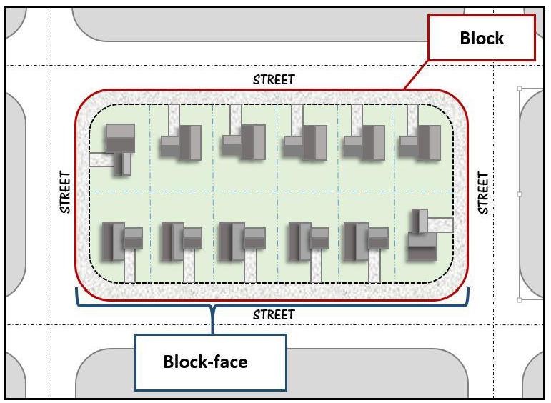
Figure 2.2.1. Block and Block-face Diagram
B.
Building Material Ratios and Standards.
(1)
Allowable building materials.
a.
Brick, and modern brick veneers that are intended to simulate brick exteriors are acceptable;
b.
Stone. Natural stone such as, but not limited to, granite, limestone, acid marble are allowed building materials. Terra cotta and/or cast stone, which simulate natural stone, are also acceptable. Painted stone is not allowed;
c.
Split-face block/concrete masonry unit (CMU) is restricted to 20 percent of the surface area of the façade;
d.
Natural wood and/or cement-based artificial wood siding;
e.
Glass;
f.
Any other material and/or combination of materials which, in the opinion of the planning board and/or city council, accomplishes the intent of this section shall be allowed.
(2)
The following building materials are limited on any façade facing a public right-of-way, excluding alleys, or any façade that abuts a lot of residential or mixed use. Such materials may be used as decorative or detail elements for up to 20 percent of the façade, or as part of the exterior construction that is not used as a surface finish material.
a.
Plain concrete block;
b.
Aluminum, steel, or other metal sidings;
c.
Exposed aggregate (rough finish) concrete wall panels and block;
d.
Tilt and/or architectural pre-cast concrete is not allowed;
e.
Exterior insulating finish systems (EIFS);
f.
T111 composite plywood siding;
g.
Plastic; and
h.
Vinyl.
(3)
Ratios and amounts of allowed building materials:
a.
Accent/trim exterior building material. Small amounts of building materials such as wood, tile, stone, etc., may be used to enhance the façade of the building or for decorative elements, but should not exceed 30 percent of total wall area per façade.
b.
Façade calculations. With the exception of accent/trim materials, there shall be no more than two primary building materials used. The allowed façade materials shall not apply to entry doors and/or roll-up doors.
c.
Calculation of permitted material amounts. The amount of permitted material shall be calculated using the gross square footage of wall area per façade.
If, for example:
A building has a front façade with a gross façade area of 1,200 square feet with 360 square feet dedicated to windows and doors:
Begin with 1,200 square feet for required building material calculations.
Subtract from the gross square footage of wall area the area of the windows and doors.
The balance of the wall area is 840 square feet.
The remaining façade shall have no more than 252 square feet of accent or trim materials (i.e., 840 × 30% = 252). The remaining façade shall be brick, stucco, or other allowable material.
C.
Build-To Dimensions.
(1)
A build-to line (BTL) is the set dimension on a lot, measured from the applicable lot line, where a certain percentage of the building frontage must be located.
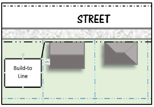
Figure 2.2.2. Build-To-Line Diagram
D.
Building Height.
(1)
Building height is measured as the vertical distance from grade to the top of the highest point of the roof or structure. This method of building height applies to all structures unless specifically exempted by this Code. The distance excludes spires, chimneys, flag poles, and the like, as described in item 2 below.
(2)
The following structures or parts thereof are exempt from maximum height limitations, unless otherwise limited by any height restriction imposed by any airport authority, or other similar federal, state, or local authority.
a.
Public utility poles, towers, and wires. This does not include wireless telecommunication towers and wind turbines that are regulated separately by this Code.
b.
Water tanks and standpipes.
c.
Building appurtenances such as chimneys, parapet walls, skylights, steeples, flag poles, smokestacks, cooling towers, elevator bulkheads, fire towers, monuments, water towers, stacks, stage towers, or scenery lofts, tanks, ornamental towers and spires, rooftop accessory structures, recreational facilities, necessary mechanical appurtenances, or penthouses to house mechanical appurtenances.
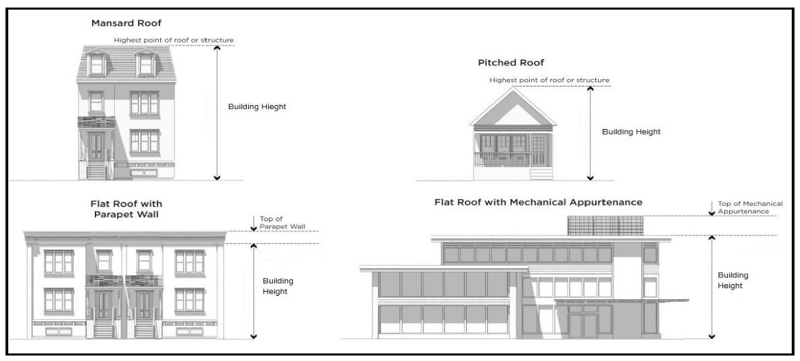
Figure 2.2.3. Building Height Diagram
(3)
A story is that portion of a building between the upper surface of any floor and the upper surface of the floor next above, including any portion of a building used for human occupancy between the topmost floor and the roof.
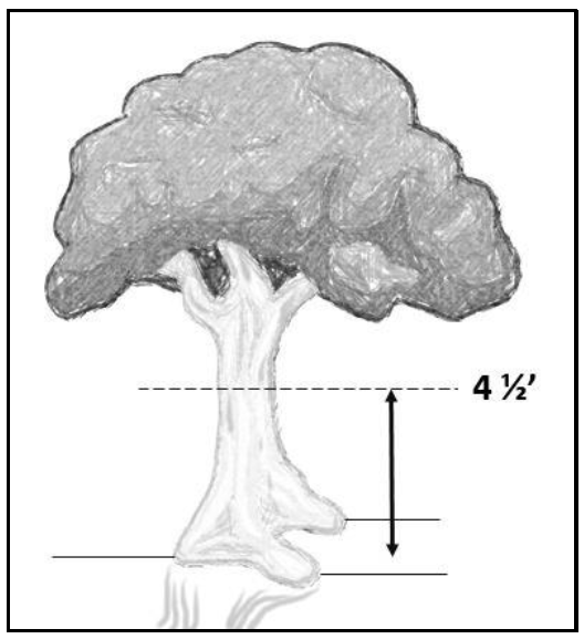
Figure 2.2.4. Caliper Diagram
E.
Caliper. Tree caliper is the diameter of a tree trunk, measured at four and one-half (4.5) feet above the adjacent ground. Commonly referred to as "Diameter at Breast Height" or DBH. All measurements of Caliper (DBH) with multiple trunks or are "multi-stemmed" at four and one-half (4.5) feet above the adjacent ground shall be performed as follows:
Multi-stemmed or multi-trunk trees shall be measured and have their caliper/diameter at breast height (dbh) determined as follows:
The square root of the sum of all squared stem caliper/dbh measurements and rounding to the nearest whole number.
Example: If a tree, at four and one-half feet above the ground, contains three trunks/stems which measure 4 inches, 8 inches and 10 inches, the caliper/dbh would be; √(4 2 +8 2 +10 2 ) = √(16+64+100)=√(180)= 13.416 inches. This number would then be rounded to the nearest whole number of 13 inches dbh.
F.
Floor Area Ratio (FAR). FAR is a measure of use intensity that may be utilized to determine the appropriateness of a development.
The formula used to determine FAR is as follows:
FAR = Total floor area of a building/the total lot area.
G.
Grade. A reference plane representing the average of finished ground level adjoining the building at all exterior walls. When the finished ground level slopes away from the exterior walls, the reference plane is established by the lowest points within the area between the building and the lot line or, when the lot line is more than six feet from the building, between the building and a point six feet from the building.
H.
Gross Floor Area (GFA). The gross floor area (GFA) of a structure is the sum of the gross horizontal areas of all floors of the structure as measured from the exterior faces of the exterior walls or from the centerline of walls separating two buildings.
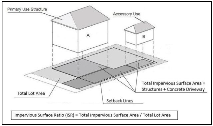
Figure 2.2.5. Impervious Surface Coverage Diagram
I.
Impervious Surface Coverage.
(1)
Impervious surface coverage is a measure of intensity of land use that represents the portion of a site that is occupied by structures, pavement, and other impervious surfaces which do not allow for the absorption of water into the ground. The Impervious Surface Ratio (ISR) of a lot is calculated by dividing the total area of impervious surface(s) by the total area of the lot.
(2)
When an approved pervious pavement system is utilized, the ISR will be calculated at a reduced rate determined by the performance measure achieved by the pervious pavement system installed.
a.
The area of approved pervious pavements and open grid paving systems will be calculated as 50% impervious surface, provided that no barrier to infiltration is installed beneath the material. Refer to Article 13 for installation and maintenance standards.
b.
Other types of pervious surfaces, such as permeable pavers, porous asphalt, or gravel-crete, and green roofs will be credited based upon field performance data and coefficients of permeability provided by the manufacturer. Refer to Article 12 for installation and maintenance standards.
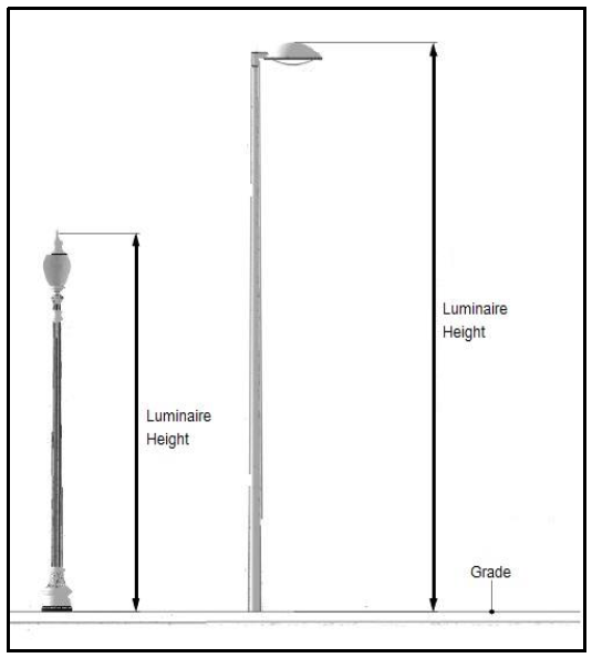
Figure 2.2.6. Lighting Height Diagram
J.
Lighting.
(1)
Luminaire Height. The total height of a luminaire is measured to the top of the pole or luminaire, whichever is higher, from grade.
(2)
Foot-candle. A foot-candle (FC) is a unit of illumination produced on a surface, all points of which are one foot from a uniform point source of one standard candle. Foot-candle is measured utilizing a direct reading, portable light meter mounted in a horizontal position.
K.
Lot. A lot is the basic development unit for determination of lot area, depth, and other dimensional regulations; or a parcel of land whose boundaries have been established by some legal instrument such as a recorded deed or recorded map and which is recognized as a separate legal entity for purposes of transfer of title. The following describes the types of lot configurations:
(1)
An interior lot is a lot other than a corner or through lot, bounded by two interior side lot lines.
(2)
A corner lot is a lot situated at the junction of, and abutting on, two or more intersecting streets.
(3)
A through lot is a lot which fronts upon two parallel streets, or which fronts upon two streets which do not intersect at the boundaries of the lot.
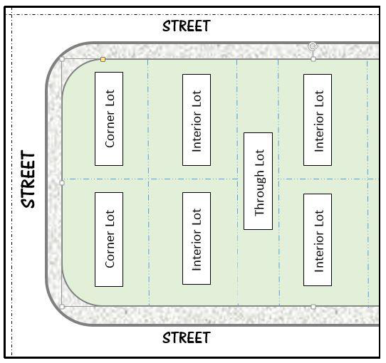
Figure 2.2.7. Lot Type Diagram
L.
Lot Area. The total area within the boundaries of a lot, excluding any street right-of-way, usually defined in acres or square feet.
M.
Lot Coverage. The amount of structure that is covering the ground, also known as the structures "foot print."
(1)
Lot Coverage Ratio. The calculated percentage or portion of the lot that is or may be covered by buildings and accessory structures. This includes all of the primary and secondary or accessory structures on the lot or parcel of land.
N.
Lot Depth. The distance measured from the front lot line to the rear lot line. For lots where the front and rear lot lines are not parallel, the lot depth is the depth calculated at the deepest part of the lot.
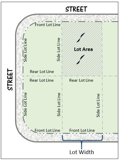
Figure 2.2.8. Lot Line and Area Diagram
O.
Lot Line. A line of record bounding a lot, as indicated on an approved, filed, and recorded subdivision plat, which divides one lot from another lot or from a public or private street or any other public or private space and includes:
(1)
A front lot line is the lot line separating a lot from a street right-of-way. The front lot line of a corner lot is the shortest street lot line of a corner lot abutting a street. A front lot line for a through lot is both lot lines that abut a street.
(2)
A rear lot line is the lot line opposite and most distant from the front lot line, or in the case of triangular or otherwise irregularly shaped lots, an assumed line at least ten feet in length entirely within the lot, parallel to and at a maximum distance from the front lot line.
(3)
On a corner lot, the corner side lot line is perpendicular or approximately perpendicular to the front lot line and is the longer street abutting lot line of a corner lot.
(4)
On an interior lot, the interior side lot line is perpendicular or approximately perpendicular to the front lot line and abuts the adjacent lot.
(5)
A street lot line is any lot line separating a lot from a street right-of-way.
P.
Lot Width. Lot width is the horizontal distance between the side lot lines measured at right angles to its depth along a straight line parallel to the front lot line at the minimum front setback line. For cul-de-sac lots or pie-shaped lots, lot width is measured at the front building line of the structure between side lot lines.
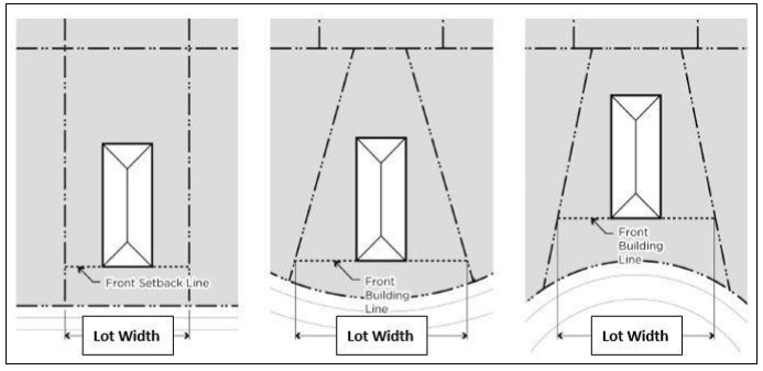
Figure 2.2.9. Lot Width Diagram
Q.
Sign Dimension Measurement.
(1)
Sign area is measured as follows:
a.
For signs on a background, the entire area of the background is calculated as sign area, including any material or color forming the sign face and the background used to differentiate the sign from the structure against which it is mounted. Sign area does not include any supports or bracing.
b.
The area of a sign shall be the area within the smallest square, rectangle, parallelogram, triangle, circle or half-circle, the sides of which touch the extreme points or edges of the sign face. For signs consisting of freestanding letters or logos, the sign area is calculated as the total area of each square, circle, rectangle, or triangle, or combination thereof, which encompasses each individual letter or logo. Sign area does not include any supports or bracing.
c.
Window signs printed on a transparent film and affixed to the interior or exterior of a windowpane are calculated as individual letters or logos, provided that the portion of the transparent film around the perimeter of the individual letters or logos maintains 100% transparency of the window.
d.
The sign area of a three-dimensional, free-form, or sculptural (non-planar) sign is calculated as 50% of the sum of the area of the four vertical sides of the smallest cube that will encompass the sign.
i.
Where two sign faces are placed back-to-back on a single sign structure, and the faces are at no point more than three feet apart, the area of the sign shall be counted as the area of one of the faces.
ii.
Where four sign faces are arranged in a square, rectangle, or diamond, the area of the sign shall be the area of the two largest faces.
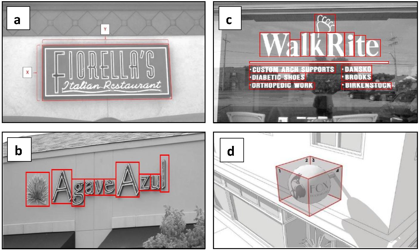
Figure 2.2.10. Sign Area Measurement Diagram
(2)
Measurement of Sign Height. For freestanding signs, height is calculated as the vertical distance measured from the ground adjacent to where the sign is to be installed to the highest point of the sign.
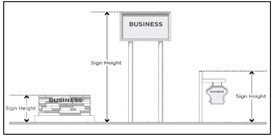
Figure 2.2.11. Sign Height Measurement Diagram
R.
Sight Triangle. A sight triangle is located at the intersection of a street or alley right-of-way and/or driveway pavement, and is measured at a line joining the points at a distance as follows:
(1)
Five (5) feet from the point of the intersection of driveways and the lot line, as measured along the lot line and edge of driveway pavement.
(2)
25 feet from the point of the intersection of streets and/or alleys (public or private) of a corner lot, as measured along the lot line.
(3)
Driveways accessing the State Highway system shall provide 25-foot sight triangles on each side.
(4)
Permitted parking lot display areas shall provide a 15-foot sight triangle at parking aisles.
(5)
Wherever a right-of-way has an arc, the measured distance begins at a point where the property lines are extended to their intersection.
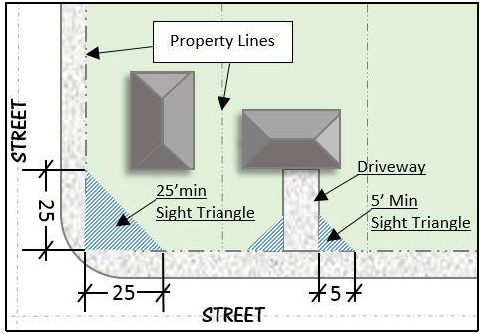
Figure 2.2.12. Sight Triangle Measurement Diagram
S.
Yards and Setbacks. A yard is the open space area between the building line of a principal building and the adjoining lot lines. A required setback is the required minimum distance a principal building must be located from a lot line, which is unoccupied and unobstructed by any portion of a principal building or accessory structure, unless permitted by this Code, and may be equal to or lesser than a yard. A setback is located along a lot line for the minimum depth specified by the zoning district in which such lot is located. A build-to zone or build-to line is considered a required setback. Under no circumstance shall any residential building or its extension encroach to within 10 feet of any other occupied residential structure, whether on the same or different property.
(1)
Front Yard and Front Setback. A front yard is located between a principal building line and the front lot line. A front setback is the required minimum distance per the zoning district that a principal building must be located from the front lot line. The front yard and front setback extend the full width of the lot between side lot lines measured perpendicular to the front lot line.
(2)
Side Yard and Interior Side Yard Setback. An interior side yard is located between a principal building line and the interior side lot line. An interior side setback is the required minimum distance per the zoning district that a principal building must be located from the interior side lot line. The interior side yard and interior side setback extend along the interior side lot line between the front and rear yard and setback, measured perpendicular to the interior side lot line. For townhouse developments, or multi-tenant retail centers or shopping centers, the interior side yard and interior side setback are applicable to end units only. For semi-detached dwellings or multi-tenant retail centers, the interior side yard and interior side yard setback do not apply to the lot line where the party wall is located.
(3)
Rear Yard and Rear Setback. A rear yard is located between a principal building line and the rear lot line. A rear setback is the required minimum distance per the zoning district that a principal building must be located from the rear lot line. The rear yard and rear setback extend between interior side lot lines, measured perpendicular to the rear lot line. In the case of a corner lot, the rear yard and rear setback extend between the interior side lot line to the required corner side setback for the, measured perpendicular to the rear lot line.
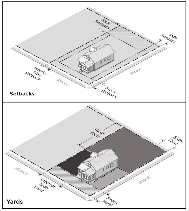
Figure 2.2.13. Setback and Yard Diagram
(Ord. No. 1992-23, § I, 10-10-2023)