
Minneapolis City Zoning Code
CHAPTER 535
- OVERLAY DISTRICTS
535.10. - Purpose.
Overlay districts are established to preserve and protect the natural environment, to encourage high quality design, to address the development of uses with unique impacts, and to protect the public health, safety, and welfare by preserving areas for future use and development.
535.20. - Establishment of overlay districts.
The overlay district names are:
(1)
HA Harmon Area Overlay District.
(2)
UA University Area Overlay District.
(3)
DH Downtown Housing Overlay District.
(4)
DP Downtown Parking Overlay District.
(5)
DS Downtown Shelter Overlay District.
(6)
SZ Split Zoning Overlay District.
(7)
TP Transitional Parking Overlay District.
(8)
AP Airport Overlay District.
(9)
SH Shoreland Overlay District.
(10)
FP Floodplain Overlay District.
(11)
MR Mississippi River Corridor Critical Area Overlay District.
535.30. - Relationship to other applicable regulations.
Property located within an overlay district shall be subject to the provisions of both the primary zoning district and the overlay district. Because overlay district regulations may be more or less restrictive than the primary zoning district, where the provisions of the overlay and primary zoning districts are in conflict, the provisions of the overlay district shall govern.
535.40. - Established boundaries.
Overlay district boundaries shall be as specified in the individual overlay district regulations. The overlay district designation shall be shown on the zoning map in addition to the primary zoning district designation.
535.50. - Eligible areas outside of established boundaries.
The city council may designate areas outside of the established boundaries in the manner provided for zoning amendments in Chapter 525, Administration and Procedures. In addition, any person having a legal or equitable interest in property located within eligible areas, as specified in the individual overlay district regulations, but outside of the established boundaries, may file a petition to request the addition of an overlay district classification to their property in the manner provided for zoning amendments in Chapter 525, Administration and Procedures.
535.100. - Purpose.
The HA Harmon Area Overlay District is established to preserve and protect the unique character of the Harmon area by encouraging the adaptive reuse of existing buildings and by limiting the height and scale of new development.
535.110. - Established boundaries.
The boundaries of the HA Overlay District shall be the areas shown on the official zoning map.
535.120. - Height.
The maximum height of all principal structures, except cluster developments, shall be eight (8) stories or one hundred twelve (112) feet, whichever is less, for properties located between Twelfth Street South, Tenth Street South, Harmon Place and LaSalle Avenue. The maximum height for all other properties shall be four (4) stories or fifty-six (56) feet, whichever is less. Parapets not exceeding three (3) feet in height shall be exempt from such limitations, except where located on cluster developments.
535.130. - Increasing maximum height.
The height limitations of principal structures may be increased as authorized by Chapter 540, Built Form Overlay Districts.
535.140. - Floor area ratio.
The maximum floor area ratio of structures shall be as specified in Chapter 540, Built Form Overlay Districts.
535.300. - Purpose.
The UA University Area Overlay District is established to ensure high quality residential development through site design and off-street parking regulations that acknowledge the unique demands placed on land uses near a major center of educational employment and enrollment.
535.310. - Established boundaries.
The boundaries of the UA University Area Overlay District shall be the areas shown on the official zoning map.
535.320. - Definitions.
As used in this article, the following definitions shall mean:
Bedroom. For the purpose of the UA University Area Overlay District, a bedroom shall be defined as any space that can operate as a sleeping area within a dwelling unit that is separated from open areas of the dwelling unit by interior walls, is greater than seventy (70) square feet, and is located along an exterior wall. Areas dedicated to other functions may be classified as bedrooms as determined by the zoning administrator. Studio and efficiency units, which have no internal walls separating living and sleeping spaces, will be considered to have one (1) bedroom. In single-, two-, and three-family dwellings, cluster developments, and common lot developments located in the BFI1 and BFI2 Built Form Overlay Districts, a bedroom greater than one hundred fifty (150) square feet shall be counted as two (2) bedrooms and every additional one hundred (100) square feet or fraction thereof shall count as an additional bedroom.
535.330. - Maximum bedroom count for single-, two-, and three-family dwellings, cluster developments, and common lot developments.
In the BFI1 and BFI2 Built Form Overlay Districts, single-, two-, and three-family dwellings, cluster developments, and common lot developments shall be limited to no more than nine (9) total bedrooms in any principal structure.
535.340. - Off-street parking location.
Off-street parking for residential uses with up to three (3) units, when located in a surface lot, shall be landscaped and screened as required by the zoning ordinance and shall be located entirely within the rear twenty-five (25) feet of the lot when an alley is present. When no alley is present, surface parking shall be limited to the rear forty (40) feet of the lot.
535.350. - Bicycle and motorized scooter parking.
Residential uses shall provide at least one (1) bicycle or motorized scooter parking space per one (1) bedroom. At least ninety (90) percent of the required parking shall comply with the standards for long-term bicycle parking in Chapter 555, Off-Street Parking, Loading, and Mobility. Such bicycle or motorized scooter parking space shall not be located in any required yard or between the principal building and a public street, except as allowed in Table 540-22, Permitted Obstructions in Required Yards.
535.400. - Purpose.
The DH Downtown Housing Overlay District is established to provide areas that offer affordable housing that may not meet the regulations of the primary zoning district, including minimum spacing requirements for congregate living residential uses.
535.410. - Established boundaries.
The boundaries of the DH Overlay District shall be the areas shown on the official zoning map.
535.420. - Eligible areas outside of established boundaries.
The DH Overlay District shall be limited to locations within the downtown area bounded by Interstate 35W, Interstate 94, Plymouth Avenue, and the Mississippi River. Any person having a legal or equitable interest in property located within the eligible area outside of the established boundaries may file a petition to request the addition of the DH Overlay District classification in the manner provided for zoning amendments in Chapter 525, Administration and Procedures.
535.430. - Conditional uses.
In addition to the conditional uses allowed in the primary zoning district, supportive housing and inebriate housing may be allowed as a conditional use in the DH Overlay District, subject to the provisions of Chapter 525, Administration and Procedures, and the following:
(1)
On-site services shall be for residents of the facility only, except where part of a regimen of scheduled post-residential treatment.
(2)
Congregate living uses, including supportive housing and inebriate housing, shall not be subject to the spacing requirements in Chapter 545, Use Regulations.
535.500. - Purpose.
The DP Downtown Parking Overlay District is established to preserve significant and useful buildings and to protect the unique character of the downtown area and the mixed-use downtown neighborhoods by restricting the establishment or expansion of surface parking lots.
535.510. - Established boundaries.
The boundaries of the DP Overlay District shall be the areas shown on the official zoning map.
535.520. - Prohibited uses.
The following uses shall be prohibited in the DP Overlay District:
(1)
Commercial parking lots, including the expansion of any existing commercial parking lot.
(2)
The conversion of any accessory parking lot to a commercial parking lot.
535.530. - Conditional uses.
In addition to the conditional uses allowed in the primary zoning district, an accessory parking lot may be allowed as a conditional use in the DP Overlay District, subject to the provisions of Chapter 525, Administration and Procedures, and the following:
(1)
The parking lot shall be located on the same zoning lot as the principal use served.
(2)
The number of parking spaces shall not exceed twenty (20) spaces.
535.600. - Purpose.
The DS Downtown Shelter Overlay District is established to provide areas that offer overnight shelter facilities that may not meet the accessory use requirements for an overnight shelter contained in the regulations of the primary zoning district.
535.610. - Established boundaries.
The boundaries of the DS Overlay District shall be the areas shown on the official zoning map.
535.620. - Eligible areas outside of established boundaries.
The DS Overlay District shall be limited to locations within the downtown area bounded by East Lyndale Avenue North, Glenwood Avenue, 10th Street North, Hawthorne Avenue, and Linden Avenue. Any person having a legal or equitable interest in property located within the eligible area outside of the established boundaries may file a petition to request the addition of the DS Overlay District classification in the manner provided for zoning amendments in Chapter 525, Administration and Procedures.
535.630. - Conditional uses.
In addition to the conditional uses allowed in the primary zoning district, an overnight shelter may be allowed as a conditional use in the DS Overlay District, subject to the provisions of Chapter 525, Administration and Procedures, and the following:
(1)
The overnight shelter shall be located on a zoning lot of at least twenty thousand (20,000) square feet.
(2)
The overnight shelter shall be located at least one thousand (1,000) feet from all existing principal overnight shelters.
(3)
The total number of shelter guests shall not exceed three hundred-fifty (350) persons.
(4)
Back-lighted signs, back-lighted awnings, portable signs, temporary signs and freestanding signs shall be prohibited.
(5)
To the extent practical, all new construction or additions to existing buildings shall be compatible with the scale and character of the surroundings, and exterior building materials shall be harmonious with other buildings in the area.
(6)
An appropriate transition area between the use and adjacent property shall be provided by landscaping, screening and other site improvements consistent with the character of the area.
(7)
Shelter guests shall be provided with an enclosed waiting area one (1) hour prior to opening each evening, except when the shelter accepts guests by appointment only or is open twenty-four (24) hours per day.
(8)
The operator shall submit a management plan for the facility, and a floor plan showing sleeping areas, emergency exits, bathing, and restrooms.
535.700. - Purpose.
The SZ Split Zoning Overlay District is established to allow more than one (1) zoning classification on a zoning lot to promote mixed-use development without requiring the expansion of commercial zoning.
535.710. - Established boundaries.
The boundaries of the SZ Overlay District shall be the areas shown on the official zoning map.
535.720. - Eligible areas outside of established boundaries.
Outside of the established boundaries, a petition may be filed to request the addition of the SZ Overlay District classification in the manner provided for zoning amendments in Chapter 525, Administration and Procedures, in any of the following situations:
(1)
Where any person has a legal or equitable interest in property located in the commercial districts and adjacent UN3 or residential mixed-use districts.
(2)
Where any person has a legal or equitable interest in adjacent properties located in different built form overlay districts with the same primary zoning.
(3)
Where any person has a legal or equitable interest in adjacent properties located in different built form overlay districts with primary zoning districts that comply with subsection (1) above.
535.730. - Maximum number of zoning districts.
A zoning lot with the SZ Overlay District shall not include more than two (2) primary zoning districts and more than two (2) built form overlay zoning districts.
535.740. - Allowed uses.
All uses, including accessory parking, shall be located only on that portion of the lot where the use is allowed by the primary zoning district.
535.750. - Lot dimension requirements.
The more restrictive of the lot area and lot width requirements of the primary zoning and built form overlay districts, including both minimum and maximum standards, shall apply to the entire development.
535.760. - Floor area ratio.
(a) Maximum floor area ratio. The more restrictive of the maximum floor area ratio requirements and allowed premiums of the built form overlay districts shall apply to the entire development.
(b)
Minimum floor area ratio. Where applicable, minimum floor area ratio requirements of the built form overlay districts shall apply to that portion of development in which the development is located.
535.770. - Height.
(a) Maximum height. Maximum height requirements of the built form overlay districts shall apply to that portion of development in which the development is located.
(b)
Height increases. Height may only be increased as authorized in each built form overlay district for that portion of development in which the development is located.
(c)
Minimum height. Where applicable, minimum height requirements of the built form overlay districts shall apply to that portion of development in which the development is located.
535.780. - Maximum lot coverage.
Maximum lot coverage requirements of each built form overlay district shall apply to that portion of development in which the development is located.
535.790. - Impervious surface coverage.
Impervious surface coverage requirements of each built form overlay district shall apply to that portion of development in which the development is located.
535.800. - Yard requirements.
(a) In general. Yard requirements of each built form overlay district shall apply to that portion of development in which the development is located.
(b)
Exception. Yards shall not be required along split zoning district boundary lines.
535.900. - Purpose.
The TP Transitional Parking Overlay District is established to allow parking lots for passenger automobiles in urban neighborhood and residential mixed-use districts when adjacent to a zoning district in need of additional parking for customers and employees that does not meet the parking location requirements of Chapter 555, Off-Street Parking, Loading, and Mobility.
535.910. - Established boundaries.
The boundaries of the TP Overlay District shall be the areas shown on the official zoning map.
535.920. - Eligible areas outside of established boundaries.
Any person having a legal or equitable interest in property located in the urban neighborhood or residential mixed-use districts outside of the established boundaries may file a petition to request the addition of the TP Overlay District classification in the manner provided for zoning amendments in Chapter 525, Administration and Procedures.
535.930. - Conditional uses.
In addition to the conditional uses allowed in the primary zoning district, the following conditional uses may be allowed in the TP Overlay District, subject to the provisions of Chapter 525, Administration and Procedures.
(1)
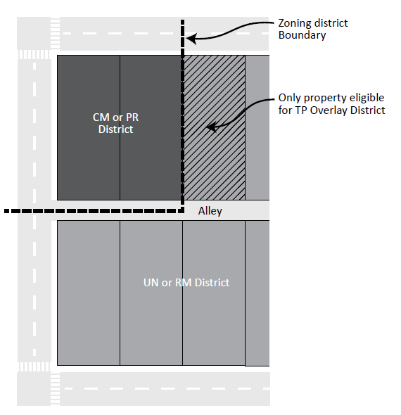
Parking lot, serving customers and employees only. Parking lots for customer and employee automobiles may be located in the TP Overlay District, subject to Chapter 555, Off-Street Parking, Loading, and Mobility, and the following standards:
a.
The parcel on which the parking lot is located shall have a side lot line that abuts the zoning district served or shall be part of the zoning lot served (see Figure 535-1, Eligible Location of TP Overlay District).
Figure 535-1 Eligible Location of TP Overlay District
b.
The width of the parking lot shall not exceed seventy-five (75) feet.
c.
The use of the parking lot shall be restricted to the parking of passenger automobiles only. No commercial vehicles shall be parked or stored.
d.
The parking lot shall be closed with a secured gate or other appropriate mechanism between the hours of 10:00 p.m. and 6:00 a.m., except as specifically authorized by the conditional use permit.
e.
The parking lot shall at no time be used for outdoor sales, display, or storage.
f.
Each entrance to and exit from such parking lot shall be located at least twenty (20) feet from any adjacent property located in an urban neighborhood district or residential mixed-use district.
g.
The parking lot shall be landscaped and screened pursuant to the provisions of Chapter 550, Development Standards.
(2)
Access to commercial mixed-use or production districts. Driveways, walkways, or other access to land in a commercial or industrial district may be located in the TP Overlay District, subject to Chapter 555, Off-Street Parking, Loading, and Mobility, and the following:
a.
The parcel on which the access area is located shall have a side lot line that abuts the zoning district served or shall be part of the zoning lot served.
b.
No commercial vehicles shall use such access area.
c.
The access area shall be closed with a secured gate or other appropriate mechanism between the hours of 10:00 p.m. and 6:00 a.m., except as specifically authorized by the conditional use permit.
d.
The access area shall at no time be used for outdoor sales, display or storage.
e.
The access area shall be located at least twenty (20) feet from any adjacent property located in an urban neighborhood or residential mixed-use district.
f.
The access area shall be landscaped and screened pursuant to the provisions of Chapter 550, Development Standards.
535.1000. - Purpose.
The AP Overlay District is established to implement the 2004 Minneapolis-St. Paul International Airport (Wold-Chamberlain Field) Zoning Ordinance (hereinafter 2004 MSP Zoning Ordinance) and to provide for the acoustical integrity of Metropolitan Airports Commission (MAC) insulated homes in the MSP noise impact area. The 2004 MSP Zoning Ordinance, pursuant to the provisions and authority of Minn. Statutes, Section 360.063, whenever more restrictive than the underlying code takes precedent within areas of the City of Minneapolis regulating and restricting the height of structures and objects of natural growth and otherwise regulating the use of property in the vicinity of the Minneapolis-St. Paul International Airport. The 2004 MSP Zoning Ordinance creates zones and establishes boundaries that extend into the City of Minneapolis. It is the purpose of the AP Overlay District to protect the public health, safety, and general welfare and to promote the most appropriate use of land by preventing the creation or establishment of Airport Hazards subject to the 2004 MSP Zoning Ordinance and Minn. Statutes.
535.1110. - Established boundaries.
The AP Overlay District shall apply to all land within the City of Minneapolis designated as Safety Zone A, Safety Zone B, and Safety Zone C in the 2004 MSP Zoning Ordinance, and those areas within airspace zones subject to height limitation restrictions identified on the 2004 MSP Airspace Zone Maps. In addition, a sub-district of noise impacted homes is established of that area of homes which has received a 5dB noise reduction treatment through sound insulation more generally described as blocks included within or intersected by the 1996 65 DNL contour and the 2007 63 and 64 DNL contours where a 5 dB treatment has been or is scheduled to be implemented; and for that area encompassed by the 2007 60, 61 and 62 DNL contours.
535.1120. - Definitions.
The following terms shall have the following definitions for the purpose of this section:
Additions. Any extension or expansion of an existing building footprint, including any increase of year around habitable indoor space, occupancy, or use.
Appurtenance. The visible, functional, or ornamental objects accessory to and part of a building not normally occupied by people including garages and accessory buildings; and other unconditioned spaces including screen porches, gazebos, decks.
Central air conditioning. An air conditioning system which uses ducts to distribute cooled and/or dehumidified air to more than one (1) room, or uses pipes to distribute chilled water to heat exchangers in more than one (1) room, and which is not plugged into a standard electrical outlet. With a typical split system, the compressor and condenser are located in an outdoor unit; the evaporator is mounted in the air handling unit (which is often a forced air furnace). With a package system, all components are located in a single outdoor unit that may be located on the ground or roof.
Consent decree. The Consent Decree signed on October 19, 2007 by Judge Stephen C. Aldrich of the Minnesota District Court, 4th Judicial District in that action entitled City of Minneapolis et al v. Metropolitan Airports Commission et al.
dBA. A unit of sound pressure level weighted by use of the A metering characteristics and weighting as specified in the American national standards institute specification for sound level meters (ANSI S1.4-1983), which is hereby incorporated by reference. "dBA" is also referred to as an A-weighted decibel.
Established residential neighborhood in a built up urban area. A low density residential structure or isolated low density residential lot which existed on or before January 1, 1978, and all other land uses which existed on or before June 30, 1979. These areas are as set forth in Exhibit B of the MSP Airport Zoning Ordinance by legal description and are shown on Exhibit C of said Ordinance.
Infill development. A vacant parcel or parcels of land proposed for development of uses similar to or less noise sensitive than the surrounding developed parcels including, but not limited to a new house on a vacant lot in a residential neighborhood.
Ldn or DNL. The day-night average level, or the twenty-four (24) hour equivalent continuous sound level (time averaged A-weighted sound level) from midnight to midnight, obtained after the addition of ten (10) dBA to sound levels measured from 10:00 p.m. to 7:00 a.m.
Major development. A parcel of land greater than two and one-half (2.5) acres with existing structures which are proposed to be extensively rehabilitated or demolished for different uses. For example, demolition of an entire block of old residential, office and hotel buildings for new housing, office, commercial uses or conversion of warehouse to office and commercial uses.
Mechanical ventilation. Controlled, purposeful introduction of outdoor air to the conditioned space. The primary purpose of a whole-house mechanical ventilation system in a home is to provide, throughout the habitable and conditioned space, a controlled amount of unpolluted outside air for indoor pollutant dilution and removal, for the sensory satisfaction of occupants and to control interior moisture and indoor air quality.
New development. A vacant parcel or parcels of land in excess of one (1) acre or requested to be rezoned for development. For example, a residential subdivision, industrial park or shopping center.
Reconstruction of existing structures. Replacing an existing building to accommodate the same use that existed before destruction or reconstruction, including indoor occupancy and use.
Runway protection zone. An area off the runway end (formerly clear zone) used to enhance the protection of people and property on the ground.
Sound attenuation. The reduction in sound level which occurs between the source and receiver by means of construction methods and materials.
Sound transmission class (STC). A single number rating for describing the degree of sound transmission loss specified for a wall, window, partition or other building element based on laboratory testing. The higher the STC, the more attenuation the building element will afford. Sound transmission loss performance shall be tested per American Society of Testing Materials (ASTM) E90 and STC rating method per ASTM E413. The same data shall be used to determine the A- weighted Noise Level Reduction (ANLR). The testing laboratory shall be certified by the National Institute of Science and Technology's, "National Voluntary Laboratory Accreditation Program" (NVLAP).
1996 Block Completion Map with 5 dB DNL Contours. The map depicting blocks with homes that are within or touched by the DNL 65-75 contours which were eligible for the 5 dB insulation package under the Metropolitan Airports Commission Part 150 Noise Mitigation Program and is incorporated herein by reference.
2007 Settlement Map with 1 dB DNL contours. The 2007 map of mitigated contours depicting city blocks with homes that are within or touched by the DNL 60-64 contours and as shown as Appendix A of the Consent Decree. This map is incorporated herein by reference.
535.1130. - Incorporation by reference.
The provisions contained in 535.1130 to 535.1170 are drawn from the Minneapolis-St. Paul International Airport (Wold-Chamberlain Field) Zoning Ordinance as amended April 29, 2004, together with Exhibits A-F which are incorporated herein by reference and are available at the City Clerk's office in Minneapolis City Hall and at the Hennepin County Recorder's Office.
535.1140. - General restrictions.
No use shall be made of any land in any of the Safety Zones A, B or C that creates or causes interference with the operations of radio or electronic facilities on the airport or with radio or electronic communications between airport and aircraft, makes it difficult for pilots to distinguish between airport lights or other lights, results in glare in eyes of pilots using the airport, impairs visibility in the vicinity of the airport, or otherwise endangers the landing, taking off, or maneuvering of aircraft. All permitted, conditional, and interim principal and accessory uses allowed in the primary zoning district are allowed in the AP Overlay District with the exception of the following prohibited uses:
(1)
Within the portion of the AP Overlay District designated as Safety Zone A as contained in Section V Land Use Safety Zoning of the 2004 MSP Zoning Ordinance and shown on MSP Zoning Map Safety Zones-Plates SZ-8, SZ-9, SZ-10, and SZ-11 there shall be no structures or trees, except structures related to airport operations or air navigation as allowed in a Runway Protection Zone by Federal laws and regulations or by FAA advisory circulars. For all runways, Safety Zone A is a trapezoidal shape beginning two hundred (200) feet off the end of the runway pavement and which is one thousand (1,000) feet wide centered on the runway centerline extended two thousand five hundred (2,500) feet outward and shall be at that point one thousand seven hundred fifty (1,750) feet wide centered on the runway centerline extended. Safety Zone A conforms to the federally described Runway Protection Zone for precision instrument runways.
(2)
Within the portion of the AP Overlay District designated as Safety Zone B as contained in Section V Land Use Safety Zoning of the 2004 MSP Zoning Ordinance and shown on MSP Zoning Map Safety Zones-Plates SZ-8, SZ-9, and SZ-10, the following uses are prohibited unless a variance permitting the use is granted by the MSP Board of Adjustment established by the 2004 MSP Zoning Ordinance:
a.
Amphitheaters.
b.
Campgrounds.
c.
Churches.
d.
Fuel storage tank farms.
e.
Above-ground fuel tanks.
f.
Gasoline stations.
g.
Hospitals.
h.
Nursing homes.
i.
Residential uses (including low, medium and high density residential uses) except in an Established Residential Neighborhood In A Built-up Urban Area.
j.
Schools.
k.
Stadiums.
l.
Theaters.
m.
Trailer courts.
n.
Ponds or other uses that might attract waterfowl or other birds such as putrescible waste disposal operations, wastewater treatment facilities and associated settling ponds, and dredge spoil containment areas; provided, however, the prohibition on ponds or other uses that might attract waterfowl or other birds shall not apply to acres below an elevation of eight hundred (800) feet above mean sea level along the Bluff of the Minnesota River.
Safety Zone B is coincident with the outer boundary of Safety Zone A and extends uniformly outward for a distance of four thousand five hundred (4,500) feet to an ultimate width of three thousand one hundred (3,100) feet centered on the runway centerline extended.
(3)
Within the portion of the AP Overlay District designated as Safety Zone C as contained in Section V Land Use Safety Zoning of the 2004 MSP Zoning Ordinance and shown on MSP Zoning Map Safety Zones-Plates SZ-2, SZ-3, SZ-4, SZ-7, SZ-8, SZ-9, and SZ-10, the general use restrictions applicable to all Safety Zones apply.
535.1150. - Exemptions.
Those portions of the AP Overlay District identified as Established Residential Neighborhood In a Built Up Urban Area and shown on MSP Zoning Maps Plates E-2, E-3, E-4, E-5, E-6, E-7, E-8, E-9, and E-10 are subject to the following exemptions:
(1)
A low density residential structure or isolated low density residential lot which existed in an Established Residential Neighborhood In a Built Up Urban Area on or before January 1, 1978, and all other land uses which existed in an Established Residential Neighborhood In a Built Up Urban Area on or before June 30, 1979, shall be subject to the height restrictions and general use restrictions, but shall not be subject to the use restrictions of Safety Zones A or B. In addition such structure, lot or use shall be deemed a conforming use that shall not be prohibited under the 2004 MSP Zoning Ordinance.
(2)
In Safety Zone B in an Established Residential Neighborhood in a Built Up Urban Area or in an area immediately adjacent to such a Neighborhood, existing low, medium, and high density residential uses may be improved and expanded and new low medium and high density residential uses may be developed subject to height restrictions, general use restrictions and noise attenuation requirements.
535.1160. - Height.
All structures in the AP Overlay District shall be subject to the height restrictions imposed by the 2004 MSP Zoning Ordinance or the Minneapolis Code of Ordinances, whichever is more restrictive and subject to the following:
(1)
Airport Overlay District. Except as necessary and incidental to MSP Airport operations, no new structure shall be constructed or established; no existing structure shall be altered, changed, rebuilt, repaired, or replaced; and no tree shall be allowed to grow or be altered, repaired or replaced, or replanted in anyway so as to project above any Airspace Surface as shown on MSP Zoning Map Airspace Zones-Plates A-1, A-2, A-3, A-4, A-7, A-8, A-9, and A-10.
(2)
Airport Permit. Within the Airport Overlay District an airport zoning permit must be applied for and granted from the City of Minneapolis if the height of a proposed structure or tree exceeds the maximum construction height as shown on MSP Maximum Construction Heights Without a Permit-Plates MCH-1, MCH-2, MCH-3, MCH-4, MCH-7, MCH-8, MCH-9, and MCH-10.
(3)
Other notification and permits. The applicant is also subject to notification requirements and approvals of Minnesota Office of Aeronautics regarding notification criteria for airspace obstruction and Federal Aviation Administration's permitting and review for Notices of Proposed Construction (FAA Form-7460-8) as set forth in Code of Federal Regulations Title 14 Part 77. Note that both MnDOT Aeronautics and FAA criteria extend beyond the boundaries of the Airport Overlay District.
535.1170. - 2004 MSP Zoning Ordinance Use Variances.
Within the AP Overlay District, variances to allow uses listed as prohibited in the AP Overlay District that are granted by the MSP Board of Adjustment pursuant to the 2004 MSP Zoning Ordinance may only be established in the City of Minneapolis to the extent that they comply with all other provisions of the Minneapolis Code of Ordinances.
535.1180. - Noise attenuation.
It is in the best interests of the city and of current and future residents that the integrity of all residential structures which have received a five (5) dB or other sound insulation package from the Metropolitan Airports Commission be maintained subject to the following:
(1)
Noise attenuation required—Expansion. Whenever construction of a habitable addition to a dwelling unit is undertaken which expands the habitable area of a dwelling unit which had previously received a five (5) db sound insulation package from the Metropolitan Airports Commission pursuant to the Consent Decree or pursuant to previous noise mitigation programs of the Metropolitan Airports Commission, the construction must include installation of central air conditioning or mechanical ventilation for the expanded area. Such construction shall utilize materials with a sound transmission class (STC) rating of at least forty (40) in order to achieve similar noise attenuation in the expansion of the structure as existed in the principal structure prior to expansion.
(2)
Noise attenuation required —Infill or tear down/rebuild residential construction. Infill construction or rebuilding of residential structures after tearing down the original structure which takes place within blocks or between structures that have received noise attenuation pursuant to the Consent Decree or pursuant to previous noise mitigation programs of the Metropolitan Airports Commission shall utilize building materials with a sound transmission class (STC) rating of at least forty (40) and shall include installation of central air conditioning or mechanical ventilation throughout the habitable areas of the structure.
(3)
Requirement within the 2007 60—62 Contours. Construction of new single-family homes located in blocks or between structures that have received noise attenuation pursuant to the Consent Decree that are in the 60 to 62 DNL contours as defined in the Consent Decree shall include installation of central air conditioning or mechanical ventilation throughout the habitable portion of the structure.
(4)
Requirement for multiple-family homes within the 2007 60—64 Contour. Construction of new multiple-family homes in blocks that have received noise attenuation pursuant to the Consent Decree or which are between structures which have received noise attenuation pursuant to the Consent Decree or pursuant to previous noise mitigation programs of the Metropolitan Airports Commission shall install central air conditioning or mechanical ventilation throughout the habitable portions of the structure.
Within each aircraft noise overlay zone, all uses shall be permitted in accordance with the regulations for the underlying zoning districts, provided the appropriate building permit is first obtained and all requirements for conditional and permitted uses under this section are met.
535.1190. - Application of provisions.
The provisions of section 535.1180 shall apply to all new development, major redevelopment, in fill development, construction and reconstruction of a building, and any habitable additions or expansions of an existing building requiring a building permit after January 1, 2009. This section shall not apply to remodeling or rehabilitation of an existing residential building; construction of decks, swimming pools, breezeways, three-season porches, or the construction of an appurtenance to an existing residential building.
535.1200. - Purpose.
The SH Shoreland Overlay District is established to preserve and enhance the environmental qualities of surface waters and the natural and economic values of shoreland areas within the city, to provide for the efficient and beneficial utilization of those waters and shoreland areas, to comply with the requirements of state law regarding the management of shoreland areas, and to protect the public health, safety, and welfare.
535.1210. - Established boundaries.
The boundaries of the SH Overlay District shall be all land located within the following distances from protected waters:
(1)
One thousand (1,000) feet from the ordinary highwater mark of a lake, pond, wetland, or flowage; or
(2)
Three hundred (300) feet from a river or stream or the landward extent of the floodplain of such river or stream, whichever is greater.
535.1220. - Definitions.
As used in this article, the following words and phrases shall mean:
Best management practices. Erosion and sediment control and water quality practices that are the most effective and practicable means of controlling, preventing and minimizing degradation of surface water.
Bluff. A steep outcropping, hill, cliff or embankment along a river or stream, with an average slope of eighteen (18) percent or greater measured over a horizontal distance of fifty (50) feet or more, and that rises at least twenty-five (25) feet above the ordinary high water mark of the protected water.
Clear cutting. The removal of an entire stand of trees, shrubs, bushes, or similar vegetation.
Development. The erection, construction, reconstruction, relocation or enlargement of any structure except stairways and seasonal docks not exceeding four (4) feet in width. Where accessory to a public park, the following shall also not be considered development:
a.
Unenclosed structures up to four hundred (400) square feet and not more than twenty (20) feet wide used for the storage of watercraft if located at least ten (10) feet from the ordinary high water mark of any protected water.
b.
Walkways, stairways, retaining walls, light poles, piers, docks and similar structures.
Ordinary highwater mark. A mark delineating the highest water level which has been maintained for a sufficient period of time to leave evidence upon the landscape. The ordinary highwater mark commonly is that point where natural vegetation changes from predominantly aquatic to predominantly terrestrial.
Protected waters. The following lakes, ponds, wetlands, streams and rivers are protected waters: Bde Maka Ska, Brownie Lake, Cedar Lake, Lake of the Isles, Lake Harriet, Lake Nokomis, Lake Hiawatha, Mother Lake, Legion Lake, Cemetery Lake, Diamond Lake, Grass Lake, Powderhorn Lake, Ryan Lake, Spring Lake, Taft Lake, Birch Pond, Bridal Veil Pond, Loring Pond, Webber Pond, wetlands mapped by the city engineer or classified by the United States Fish and Wildlife Service, Bassett Creek, Minnehaha Creek and Shingle Creek and the Mississippi River.
Steep slope. Land having an average slope of eighteen (18) percent or greater measured over a horizontal distance of fifty (50) feet or more. Steep slopes that are less than ten (10) feet in height shall not be considered a steep slope.
Surface water oriented uses. Land uses in which access to or use of a surface water feature is an integral component, such as boathouses, docks, marinas, observation platforms and water control structures including locks and dams.
Top of steep slope. The contour at which the slope ceases to be eighteen (18) percent or more.
535.1230. - Location of development.
(a) Location prohibited except as authorized by variance. Except as allowed in section 535.1230(b) or where approved by a variance as provided in this article and Chapter 525, Administration and Procedures, development in the SH Overlay District shall be prohibited on steep slopes or within forty (40) feet of the top of a steep slope or bluff, and shall not be located within fifty (50) feet of the ordinary high water mark of any protected water. Development authorized by variance shall be subject to the following:
(1)
Development must currently exist on the steep slope or within forty (40) feet of the top of a steep slope within five hundred (500) feet of the proposed development.
(2)
The foundation and underlying material shall be adequate for the slope condition and soil type.
(3)
The development shall present no danger of falling rock, mud, uprooted trees or other materials.
(4)
The view of the developed slope from the protected water shall be consistent with the natural appearance of the slope, with any historic areas, and with the surrounding physical context.
(b)
Location restricted except as authorized by conditional use permit. Conditional uses authorized in the primary zoning district are also authorized in the SH Overlay District and are subject to section 535.1230(a). Notwithstanding section 535.1230(a), the following uses may be allowed in all areas of the SH Overlay District by conditional use permit rather than variance as provided in this article and Chapter 525, Administration and Procedures.
(1)
Public parks and surface water-oriented development on steep slopes or within forty (40) feet of the top of a steep slope, other than bluffs, or within fifty (50) feet of the ordinary high water mark of any protected water, where allowed by the primary zoning district, provided the development does not cause a hazard to water navigation.
(2)
Electrical transmission services of under two hundred twenty (220) kilovolts, subject to the following conditions:
a.
When routing transmission services, all of the following shall be avoided where practicable:
1.
Steep slopes, streams, rivers, valleys and open exposures of water, wetlands, wooded areas, ridge crests and open space recreation areas.
2.
Soils susceptible to erosion, which would create sedimentation and pollution problems, and areas of unstable soils which would be subject to extensive slippage.
3.
Areas with high water tables, especially if construction requires excavation.
b.
The structural design of transmission services shall consider the following:
1.
Underground placement shall be preferred in order to minimize visual impact. If above ground placement is proposed, the applicant shall describe the economic, technological or land characteristics which make underground placement infeasible.
2.
If above ground placement is necessary, the appearance of any structures shall be made as compatible as practicable with the natural area with regard to height, width, materials used and color.
3.
The cleared portion of the right-of-way shall be kept to a minimum.
4.
Crossing points over protected waters shall be consolidated with other public facilities and rights-of-way so that the smallest area possible is devoted to crossing.
c.
In the construction of transmission service, effective erosion and sedimentation control programs shall be conducted during all clearing, construction or reconstruction operations in order to prevent the degradation of surface waters and adjacent lands.
d.
Right-of-way maintenance shall comply with the following:
1.
Natural vegetation of value to fish or wildlife, which does not pose a hazard to or restrict reasonable use of the utility, shall be allowed to grow in the right-of-way.
2.
Where vegetation has been removed, new vegetation consisting of native grasses, herbs, shrubs and low-growing trees shall be planted and maintained on the right-of-way.
3.
Chemical control of vegetation shall be avoided. Where such methods are necessary, chemicals used and the manner of their use shall be in accordance with rules, regulations and other requirements of all state and federal agencies with authority over the use, and best management practices shall be followed.
535.1240. - Height of structures.
(a) Maximum height. Except for structures subject to a more restrictive maximum height limitation in this zoning ordinance or a less restrictive maximum height limitation in the MR Mississippi River Corridor Critical Area Overlay District between North Plymouth Avenue and Interstate 35W, the maximum height of structures within the SH Overlay District shall be two and one-half (2.5) stories or thirty-five (35) feet, whichever is less.
(b)
Increasing maximum height. An increase to the applicable maximum height requirements for properties in the SH Overlay District may be requested, subject to the following:
(1)
The height limitations for the following uses and structures may only be increased by variance, as provided in Chapter 525, Administration and Procedures.
a.
Accessory structures.
b.
Single-, two-, or three-family dwellings or cluster developments located in any built form overlay district.
c.
Principal structures located in the BFI1, BFI2, or BFI3 Built Form Overlay Districts.
(2)
The height limitations of all other structures not contained within subsection (b)(1) of this ordinance may only be increased by conditional use permit, as provided in Chapter 525, Administration and Procedures. Where an increase in height would exceed the maximum height requirements of the built form overlay district, the height increase shall comply with the applicable requirements for height increase limits and premiums of the built form overlay district in which the property is located. In addition to the conditional use standards contained in Chapter 525, Administration and Procedures, the city planning commission shall consider, but not be limited to, the following factors when determining maximum height:
a.
The building furthers principles of human scale design and massing, particularly facing the public realm in the lower floors of the building.
b.
The portion of the building receiving the height increase responds to a change in built form on adjacent properties in less intense built form overlay districts with a gradual transition in height and scale.
c.
The building form and massing is distributed and oriented in a manner appropriate to the scale and proportion of the built surroundings to reasonably address the impact of shadowing on adjacent properties, the public realm, and existing solar energy systems, and to allow access to light and air of adjacent properties.
d.
Exterior materials are consistent and compatible on all sides of the building.
(c)
Height of structure when determining required yards. For the purpose of determining a minimum required yard where such yard is based on a structure's height, the method of determining the height of a principal structure shall be identical to the method used for properties located outside of the SH Shoreland Overlay District.
535.1250. - Lot dimensions.
(a) In general. Zoning lots located within or partially within the SH Overlay District shall be subject to the lot dimension requirements of section 540.720, unless otherwise required by this section.
(b)
Residential uses with four (4) or more dwelling units in the BFI2 Interior 2 Built Form Overlay District.
(1)
Minimum lot dimensions. The minimum lot width shall be eighty (80) feet. The minimum lot area shall be ten thousand (10,000) square feet.
(2)
Maximum lot dimensions. The maximum lot size requirements of Chapter 540, Built Form Overlay Districts, shall apply.
(c)
Existing nonconforming lots. Existing zoning lots nonconforming as to the maximum lot area shall comply with section 540.740.
535.1260. - Conditional uses and variances.
(a) Evaluation criteria. In addition to the conditional use and variance standards contained in Chapter 525, Administration and Procedures, the city planning commission and board of adjustment shall consider the following:
(1)
The prevention of soil erosion or other possible pollution of public waters, both during and after construction.
(2)
Limiting the visibility of structures and other development from protected waters.
(3)
The suitability of the protected water to safely accommodate the types, uses and numbers of watercraft that the development may generate.
535.1270. - Development on slopes between twelve (12) and eighteen (18) percent.
Development on slopes between twelve (12) and eighteen (18) percent, other than bluffs, where allowed by the primary zoning district, provided the development is not located within fifty (50) feet of the ordinary high water mark of any protected water, may be allowed in the SH Overlay District subject to the regulations of this article, Chapter 550, Development Standards, and the following conditions:
(1)
The foundation and underlying material shall be adequate for the slope condition and soil type.
(2)
The development shall present no danger of falling rock, mud, uprooted trees or other materials.
(3)
The view of the developed slope from the protected water shall be consistent with the natural appearance of the slope, with any historic areas, and with surrounding architectural features.
535.1280. - Grading and filling.
Grading or filling involving more than ten (10) cubic yards where the slope of the land is toward a protected water shall be prohibited within the SH Overlay District except where authorized by an erosion control plan approved by the city engineer and the zoning administrator, subject to the following conditions:
(1)
The smallest amount of bare ground shall be exposed for as short a time as feasible.
(2)
Temporary ground cover, such as mulch, shall be used and permanent ground cover, such as turf grass, native grasses or other perennial flowering plants, vines, shrubs or trees shall be established.
(3)
Best management practices to prevent erosion and trap sediment shall be employed to ensure that soil loss levels do not degrade the protected water.
(4)
Fill shall be stabilized to accepted engineering standards.
(5)
Any work which will change or diminish the course, current or cross-section of a protected water shall be prohibited except where approved by the commissioner of natural resources.
(6)
The top of a riverbank or lake bank shall not be moved closer to the protected water.
(7)
Such grading or filling shall comply with the provisions of Chapter 52, Erosion and Sediment Control for Land Disturbance Activities, of the Minneapolis Code of Ordinances.
535.1290. - Removal of vegetation.
Removal of vegetation on steep slopes or bluffs or within forty (40) feet of the top of steep slopes or bluffs, or within fifty (50) feet of the ordinary high water mark of any protected water, shall be prohibited within the SH Overlay District except as authorized by the zoning administrator subject to the following conditions:
(1)
Clear cutting of vegetation shall be prohibited, except as necessary for an approved development and subject to the requirements of this article and Chapter 550, Development Standards. This provision shall not prevent the removal of noxious weeds or dead or diseased vegetation.
(2)
Selective removal of vegetation shall be allowed, subject to the requirements of this article and Chapter 550, Development Standards, provided sufficient vegetative cover remains to screen parking areas, dwellings and other structures when viewed from the protected water and provided a continuous natural cover is maintained.
(3)
Vegetation shall be restored to the extent feasible after any construction project is completed to retard surface runoff and soil erosion and to provide screening. Restoration shall be completed as soon as feasible, but in no case later than the beginning of the next growing season following the completion of a project.
(4)
Best management practices to prevent erosion and trap sediment shall be employed to ensure that soil loss levels do not degrade the protected water.
535.1300. - Stormwater management.
All development shall comply with all applicable regulations governing stormwater management, and shall employ best management practices to minimize off-site stormwater runoff, maximize overland flow and flow distances over surfaces covered with vegetation, increase on-site filtration, replicate predevelopment hydrologic conditions as nearly as possible, minimize off-site discharge of pollutants to ground and surface water, and encourage natural filtration function.
535.1400. - Statutory authorization.
The legislature of the State of Minnesota has, in Minn. Statutes, Chapter 103F and Chapter 462 delegated the responsibility to local government units to adopt regulations designed to minimize flood losses.
535.1410. - Purpose.
(a) Regulation of development. This ordinance regulates development in the flood hazard areas of the City of Minneapolis. These flood hazard areas are subject to periodic inundation, which may result in loss of life and property, health and safety hazards, disruption of commerce and governmental services, extraordinary public expenditures for flood protection and relief, and impairment of the tax base. It is the purpose of this ordinance to promote the public health, safety, and general welfare by minimizing these losses and disruptions.
(b)
National Flood Insurance Program compliance. This ordinance is adopted to comply with the rules and regulations of the National Flood Insurance Program codified as 44 Code of Federal Regulations Parts 59—78, as amended, so as to maintain the community's eligibility in the National Flood Insurance Program.
(c)
Preservation of natural features. This ordinance is also intended to preserve the natural characteristics and functions of watercourses and floodplains in order to moderate flood and stormwater impacts, improve water quality, reduce soil erosion, protect aquatic and riparian habitat, provide recreational opportunities, provide aesthetic benefits and enhance community and economic development.
535.1420. - General provisions.
(a) How to use this ordinance. This ordinance adopts the floodplain maps applicable to the City of Minneapolis and includes two (2) floodplain districts: Floodway and Flood Fringe.
Where Floodway and Flood Fringe Districts are delineated on the floodplain maps, the standards in section 535.1470 or 535.1480 will apply, depending on the location of a property.
(b)
Lands to which ordinance applies. This ordinance applies to all lands within the jurisdiction of the City of Minneapolis shown on the official zoning map and/or the attachments to the map as being located within the boundaries of the Floodway or Flood Fringe District.
The Floodway and Flood Fringe Districts are overlay districts that are superimposed on all existing zoning districts. The standards imposed in the overlay districts are in addition to any other requirements in this ordinance. In case of a conflict, the more restrictive standards will apply.
(c)
Incorporation of maps by reference. The following maps together with all attached material are hereby adopted by reference and declared to be a part of the official zoning map and this ordinance. The attached material includes the Flood Insurance Study for Hennepin County, Minnesota, and Incorporated Areas, dated November 4, 2016 and the flood insurance rate map panels enumerated here within, dated November 4, 2016, all prepared by the Federal Emergency Management Agency. These materials are on file in the office of the zoning administrator. The effective flood insurance rate map panels are: 27053C0212F, 27053C0214F, 27053C0216F, 27053C0217F, 27053C0218F, 27053C0219F, 27053C0352F, 27053C0354F, 27053C0356F, 27053C0357F, 27053C0362F, 27053C0364F, 27053C0366F, 27053C0367F, 27053C0368F, 27053C0369F, 27053C0376F, 27053C0378F, 27053C0379F, 27053C0386F, 27053C0387F, 27053C0388F, 27053C0389F.
(d)
Interpretation. The boundaries of the zoning districts are determined by scaling distances on the flood insurance rate map. Where a conflict exists between the floodplain limits illustrated on the official zoning map and actual field conditions, the flood elevations shall be the governing factor. The zoning administrator shall interpret the boundary location based on the ground elevations that existed on the site on the date of the first National Flood Insurance Program map showing the area within the regulatory floodplain, and other available technical data.
(e)
Abrogation and greater restrictions. It is not intended by this ordinance to repeal, abrogate, or impair any existing easements, covenants, or other private agreements. However, where this ordinance imposes greater restrictions, the provisions of this ordinance prevail.
(f)
Warning and disclaimer of liability. This ordinance does not imply that areas outside the floodplain districts or land uses permitted within such districts will be free from flooding or flood damages. This ordinance does not create liability on the part of the City of Minneapolis or its officers or employees for any flood damages that result from reliance on this ordinance or any administrative decision lawfully made hereunder.
(g)
Severability. If any section, clause, provision, or portion of this ordinance is adjudged unconstitutional or invalid by a court of law, the remainder of this ordinance shall not be affected and shall remain in full force.
535.1430. - Definitions.
Unless specifically defined below, words or phrases used in this ordinance must be interpreted according to common usage and so as to give this ordinance its most reasonable application.
Base flood elevation. The elevation of the "regional flood." The term "base flood elevation" is used in the flood insurance survey.
Basement. Any area of a structure, including crawl spaces, having its floor or base subgrade (below ground level) on all four (4) sides, regardless of the depth of excavation below ground level.
Critical facilities. Facilities necessary to a community's public health and safety, those that store or produce highly volatile, toxic or water-reactive materials, and those that house occupants that may be insufficiently mobile to avoid loss of life or injury. Examples of critical facilities include hospitals, correctional facilities, schools, daycare facilities, nursing homes, fire and police stations, wastewater treatment facilities, public electric utilities, water plants, fuel storage facilities, and waste handling and storage facilities.
Development. Any manmade change to improved or unimproved real estate, including buildings or other structures, mining, dredging, filling, grading, paving, excavation or drilling operations, or storage of equipment or materials.
Equal degree of encroachment. A method of determining the location of floodway boundaries so that floodplain lands on both sides of a stream are capable of conveying a proportionate share of flood flows.
Flood. A temporary increase in the flow or stage of a stream or in the stage of a wetland or lake that results in the inundation of normally dry areas.
Flood frequency. The frequency for which it is expected that a specific flood stage or discharge may be equaled or exceeded.
Flood fringe. The portion of the special flood hazard area (one (1) percent annual chance flood) located outside of the floodway. Flood fringe is synonymous with the term "floodway fringe" used in the flood insurance study for Hennepin County, Minnesota.
Flood insurance rate map (FIRM). An official map on which the Federal Insurance Administrator has delineated both the special hazard areas and the risk premium zones applicable to the community. A FIRM that has been made available digitally is called a digital flood insurance rate map (DFIRM).
Flood prone area. Any land susceptible to being inundated by water from any source (see "flood").
Floodplain. The beds proper and the areas adjoining a wetland, lake or watercourse which have been or hereafter may be covered by the regional flood.
Floodproofing. A combination of structural provisions, changes, or adjustments to properties and structures subject to flooding, primarily for the reduction or elimination of flood damages.
Floodway. The bed of a wetland or lake and the channel of a watercourse and those portions of the adjoining floodplain which are reasonably required to carry or store the regional flood discharge.
Lowest floor. The lowest floor of the lowest enclosed area (including basement). An unfinished or flood resistant enclosure, used solely for parking of vehicles, building access, or storage in an area other than a basement area, is not considered a building's lowest floor; provided that such enclosure is not built so as to render the structure in violation of the applicable non-elevation design requirements of 44 Code of Federal Regulations, Part 60.3.
Manufactured home. A structure, transportable in one (1) or more sections, which is built on a permanent chassis and is designed for use with or without a permanent foundation when attached to the required utilities. The term "manufactured home" does not include the term "recreational vehicle."
New construction. Structures, including additions and improvements, and placement of manufactured homes, for which the start of construction commenced on or after the effective date of this ordinance.
Obstruction. Any dam, wall, wharf, embankment, levee, dike, pile, abutment, projection, excavation, channel modification, culvert, building, wire, fence, stockpile, refuse, fill, structure, or matter in, along, across, or projecting into any channel, watercourse, or regulatory floodplain which may impede, retard, or change the direction of the flow of water, either in itself or by catching or collecting debris carried by such water.
One hundred (100) year floodplain. Lands inundated by the "regional flood" (see definition).
Reach. A hydraulic engineering term to describe a longitudinal segment of a stream or river influenced by a natural or manmade obstruction. In an urban area, the segment of a stream or river between two (2) consecutive bridge crossings would most typically constitute a reach.
Recreational vehicle. A vehicle that is built on a single chassis, is four hundred (400) square feet or less when measured at the largest horizontal projection, is designed to be self-propelled or permanently towable by a light duty truck, and is designed primarily not for use as a permanent dwelling but as temporary living quarters for recreational, camping, travel, or seasonal use. For the purposes of this ordinance, the term recreational vehicle is synonymous with the term "travel trailer/travel vehicle."
Regional flood. A flood which is representative of large floods known to have occurred generally in Minnesota and reasonably characteristic of what can be expected to occur on an average frequency in the magnitude of the one (1) percent chance or one hundred (100) year recurrence interval. Regional flood is synonymous with the term "base flood" used in a flood insurance study.
Regulatory flood protection elevation (RFPE). An elevation not less than one (1) foot above the elevation of the regional flood plus any increases in flood elevation caused by encroachments on the floodplain that result from designation of a floodway. In Zone AO, the RFPE is established by adding one (1) foot to the highest adjacent grade to a structure's proposed location on the ground.
Repetitive loss. Flood related damages sustained by a structure on two (2) separate occasions during a ten-year period for which the cost of repairs at the time of each such flood event on the average equals or exceeds twenty-five (25) percent of the market value of the structure before the damage occurred.
Special flood hazard area. A term used for flood insurance purposes synonymous with "one hundred (100) year floodplain."
Start of construction. Includes substantial improvement, and means the actual start of construction, repair, reconstruction, rehabilitation, addition, placement or other improvement that occurred before the permit's expiration date. The actual start is either the first placement of permanent construction of a structure on a site, such as the pouring of slab or footings, the installation of piles, the construction of columns, or any work beyond the stage of excavation; or the placement of a manufactured home on a foundation. Permanent construction does not include land preparation, such as clearing, grading and filling; nor does it include the installation of streets and/or walkways; nor does it include excavation for a basement, footings, piers, foundations, or the erection of temporary forms; nor does it include the installation on the property of accessory buildings, such as garages or sheds not occupied as dwelling units or not part of the main structure. For a substantial improvement, the actual start of construction means the first alteration of any wall, ceiling, floor, or other structural part of a building, whether or not that alteration affects the external dimensions of the building.
Structure. Anything constructed or erected on the ground or attached to the ground or on-site utilities, including, but not limited to, buildings, factories, sheds, detached garages, fences, manufactured homes, recreational vehicles not meeting the exemption criteria specified in section 535.1510(b) of this ordinance and other similar items.
Substantial damage. Damage of any origin sustained by a structure where the cost of restoring the structure to its before damaged condition would equal or exceed fifty (50) percent of the market value of the structure before the damage occurred.
Substantial improvement. Within any consecutive three hundred sixty-five-day period, any reconstruction, rehabilitation (including normal maintenance and repair), repair after damage, addition, or other improvement of a structure, the cost of which equals or exceeds fifty (50) percent of the market value of the structure before the "start of construction" of the improvement. This term includes structures that have incurred "substantial damage," regardless of the actual repair work performed. The term does not, however, include either:
a.
Any project for improvement of a structure to correct existing violations of state or local health, sanitary, or safety code specifications which have been identified by the local code enforcement official and which are the minimum necessary to assure safe living conditions.
b.
Any alteration of a "historic structure," provided that the alteration will not preclude the structure's continued designation as a "historic structure." For the purpose of this ordinance, "historic structure" is as defined in 44 Code of Federal Regulations, Part 59.1.
535.1440. - Administration.
(a) Zoning administrator. The zoning administrator shall administer and enforce this ordinance.
(b)
Permit requirements; permit required. A permit must be obtained from the zoning administrator prior to conducting the following activities:
(1)
The erection, addition, modification, rehabilitation, or alteration of any building, structure, or portion thereof. Normal maintenance and repair also requires a permit if such work, separately or in conjunction with other planned work, constitutes a substantial improvement as defined in this ordinance.
(2)
The use or change of use of a building, structure, or land.
(3)
The construction of a dam, fence, or on-site septic system.
(4)
The change or extension of a nonconforming use.
(5)
The repair of a structure that has been damaged by flood, fire, tornado, or any other source.
(6)
The placement of fill, excavation of materials, or the storage of materials or equipment within the floodplain.
(7)
Relocation or alteration of a watercourse (including new or replacement culverts and bridges), unless a public waters work permit has been applied for.
(8)
Any other type of "development" as defined in this ordinance.
(c)
Application for permit. Permit applications must be submitted to the zoning administrator on forms provided by the zoning administrator. The permit application must include the following as applicable:
(1)
A site plan showing all pertinent dimensions, existing or proposed buildings, structures, and significant natural features having an influence on the permit.
(2)
Location of fill or storage of materials in relation to the stream channel.
(3)
Copies of any required municipal, county, state or federal permits or approvals.
(4)
Other relevant information requested by the zoning administrator as necessary to properly evaluate the permit application.
(d)
Certificate of zoning compliance for a new, altered, or nonconforming use. No building, land or structure may be occupied or used in any manner until a certificate of zoning compliance has been issued by the zoning administrator stating that the use of the building or land conforms to the requirements of this ordinance.
(e)
Certification. The applicant is required to submit certification by a registered professional engineer, registered architect, or registered land surveyor that the finished fill and building elevations were accomplished in compliance with the provisions of this ordinance. Floodproofing measures must be certified by a registered professional engineer or registered architect.
(f)
Record of first floor elevation. The zoning administrator shall maintain a record of the elevation of the lowest floor (including basement) of all new structures and alterations or additions to existing structures in the floodplain. The zoning administrator must also maintain a record of the elevation to which structures and alterations or additions to structures are floodproofed.
(g)
Notifications for watercourse alterations. Before authorizing any alteration or relocation of a river or stream, the zoning administrator must notify adjacent communities. If the applicant has applied for a permit to work in public waters pursuant to Minn. Statutes, Section 103G.245, this will suffice as adequate notice. A copy of the notification must also be submitted to the Chicago Regional Office of the Federal Emergency Management Agency (FEMA).
(h)
Notification to FEMA when physical changes increase or decrease base flood elevations. As soon as is practicable, but not later than six (6) months after the date such supporting information becomes available, the zoning administrator must notify the Chicago Regional Office of FEMA of the changes by submitting a copy of the relevant technical or scientific data.
535.1450. - Variances and conditional use permits.
(a) Additional requirements. An application for a variance to the provisions of this ordinance or for a conditional use permit will be processed and reviewed in accordance with applicable state statutes and Chapter 525, Administration and Procedures, and shall be subject to the additional provisions of this section.
(b)
Variances.
(1)
Adherence to state floodplain management standards. A variance shall not allow a use that is not allowed in that district, permit a lower degree of flood protection than the regulatory flood protection elevation for the particular area, or permit standards lower than those required by state law.
(2)
Additional variance criteria. The following additional variance criteria of the Federal Emergency Management Agency must be satisfied:
a.
Variances shall not be issued by a community within any designated regulatory floodway if any increase in flood levels during the base flood discharge would result.
b.
Variances may only be issued by a community upon:
1.
A showing of good and sufficient cause;
2.
A determination that failure to grant the variance would result in exceptional hardship to the applicant; and
3.
A determination that the granting of a variance will not result in increased flood heights, additional threats to public safety, extraordinary public expense, create nuisances, cause fraud on or victimization of the public, or conflict with existing local laws or ordinances.
c.
Variances may only be issued upon a determination that the variance is the minimum necessary, considering the flood hazard, to afford relief.
(3)
The zoning administrator shall notify the applicant for a variance that:
a.
The issuance of a variance to construct a structure below the base flood level will result in increased premium rates for flood insurance up to amounts as high as twenty-five dollars ($25.00) for one hundred dollars ($100.00) of insurance coverage; and
b.
Such construction below the base or regional flood level increases risks to life and property.
Such notification shall be maintained with a record of all variance actions.
(4)
The City of Minneapolis shall submit hearing notices for proposed variances to the DNR sufficiently in advance to provide at least ten (10) days' notice of the hearing. The notice may be sent by electronic mail or U.S. mail to the respective DNR area hydrologist.
(5)
A copy of all decisions granting variances shall be forwarded to the DNR within ten (10) days of such action. The notice may be sent by electronic mail or U.S. mail to the respective DNR area hydrologist.
(6)
The zoning administrator shall maintain a record of all variance actions, including justification for their issuance, and shall report such variances in an annual or biennial report to the administrator of the National Flood Insurance Program, when requested by the Federal Emergency Management Agency.
(c)
Conditional uses.
(1)
In passing upon conditional use applications, the city must consider all relevant factors specified in other sections of this ordinance, and those factors identified in section 535.1450(d).
(2)
The city may attach such conditions to the granting of conditional use permits as it deems necessary to fulfill the purposes of this ordinance. Such conditions may include, but are not limited to, the following:
a.
Modification of waste treatment and water supply facilities.
b.
Limitations on period of use, occupancy, and operation.
c.
Imposition of operational controls, sureties, and deed restrictions.
d.
Requirements for construction of channel modifications, compensatory storage, dikes, levees, and other protective measures.
e.
Floodproofing measures, in accordance with the state building code and this ordinance. The applicant must submit a plan or document certified by a registered professional engineer or architect that the floodproofing measures are consistent with the regulatory flood protection elevation and associated flood factors for the particular area.
(3)
The city shall submit hearing notices for proposed conditional uses to the DNR sufficiently in advance to provide at least ten (10) days' notice of the hearing. The notice may be sent by electronic mail or United States Mail to the respective DNR area hydrologist.
(4)
A copy of all decisions granting conditional uses shall be forwarded to the DNR within ten (10) days of such action. The notice may be sent by electronic mail or United States mail to the respective DNR area hydrologist.
(d)
General considerations. The following factors may be considered in granting variances and imposing conditions on variances and conditional uses in floodplains:
(1)
The potential danger to life and property due to increased flood heights or velocities caused by encroachments;
(2)
The danger that materials may be swept onto other lands or downstream to the injury of others;
(3)
The proposed water supply and sanitation systems, if any, and the ability of these systems to minimize the potential for disease, contamination and unsanitary conditions;
(4)
The susceptibility of any proposed use and its contents to flood damage and the effect of such damage on the individual owner;
(5)
The importance of the services to be provided by the proposed use to the community;
(6)
The requirements of the facility for a waterfront location;
(7)
The availability of viable alternative locations for the proposed use that are not subject to flooding;
(8)
The compatibility of the proposed use with existing development and development anticipated in the foreseeable future;
(9)
The relationship of the proposed use to the comprehensive land use plan and floodplain management program for the area;
(10)
The safety of access to the property in times of flood for ordinary and emergency vehicles; and
(11)
The expected heights, velocity, duration, rate of rise and sediment transport of the flood waters expected at the site.
535.1460. - Establishment of districts.
(a) Floodway District. The Floodway District includes those areas within Zones AE that have a floodway delineated or AO as shown on the flood insurance rate map adopted in section 535.1420(c). For lakes, wetlands and other basins within Zones AE that do not have a floodway delineated, the Floodway District also includes those areas that are at or below the ordinary high water level as defined in Minn. Statutes, Section 103G.005, subdivision 14.
(b)
Flood Fringe District. The Flood Fringe District includes areas within Zones AE that have a floodway delineated on the flood insurance rate map adopted in section 535.1420(c), but are located outside of the floodway. For lakes, wetlands and other basins within Zones AE that do not have a floodway delineated, the Flood Fringe District also includes those areas below the one (1) percent annual chance one hundred (100) year flood elevation but above the ordinary high water level as defined in Minn. Statutes, Section 103G.005, subdivision 14.
(c)
Applicability. Within the floodplain districts established in this ordinance, the use, size, type, and location of development must comply with the terms of this ordinance and other applicable regulations. In no cases shall floodplain development adversely affect the efficiency or unduly restrict the capacity of the channels or floodways of any tributaries to the main stream, drainage ditches, or any other drainage facilities or systems. All uses not listed as permitted uses or conditional uses in section 535.1470 or 535.1480 are prohibited. In addition, critical facilities, as defined in section 535.1430 are prohibited in all floodplain districts.
535.1470. - Floodway District.
(a) Permitted uses in the Floodway District. The following uses, subject to the standards set forth in section 535.1470(b), are permitted uses if otherwise allowed in the underlying zoning district or any applicable overlay district:
(1)
Outdoor plant nurseries.
(2)
Parking and loading areas.
(3)
Open space uses, including but not limited to private and public golf courses, tennis courts, driving ranges, archery ranges, picnic grounds, boat launching ramps, swimming areas, parks, wildlife and nature preserves, game farms, fish hatcheries, shooting preserves, hunting and fishing areas, and single or multiple purpose recreational trails.
(4)
Residential lawns, gardens, parking areas, and play areas.
(5)
Railroads, streets, bridges, utility transmission lines and pipelines, provided that the Department of Natural Resources' Area Hydrologist is notified at least ten (10) days prior to issuance of any permit.
(b)
Standards for permitted uses in the Floodway District.
(1)
The use must have low flood damage potential.
(2)
The use must not obstruct flood flows or cause any increase in flood elevations and must not involve structures, obstructions, or storage of materials or equipment.
(3)
Any facility that will be used by employees or the general public must be designed with a flood warning system that provides adequate time for evacuation if the area is inundated to a depth and velocity such that the depth (in feet) multiplied by the velocity (in feet per second) would exceed a product of four (4) upon occurrence of the regional one (1) percent chance flood.
(c)
Conditional uses in the Floodway District. The following uses may be allowed as conditional uses following the standards and procedures set forth in section 535.1450 of this ordinance and further subject to the standards set forth in section 535.1470(d) if otherwise allowed in the underlying zoning district or any applicable overlay district.
(1)
Structures accessory to a permitted or conditional use.
(2)
Storage of sand, gravel, and other materials.
(3)
Marinas, boat rentals, docks, piers, wharves, and water control structures.
(4)
Storage yards for equipment, machinery, or materials.
(5)
Placement of fill or construction of fences that obstruct flood flows.
(6)
Travel-ready recreational vehicles meeting the exception standards in section 535.1510(b).
(d)
Standards for floodway conditional uses.
(1)
A conditional use shall not cause any increase in the stage of the one (1) percent chance or regional flood or cause an increase in flood damages in the reach or reaches affected.
(2)
Fill; storage of materials and equipment.
a.
The storage or processing of materials that are, in time of flooding, flammable, explosive, or potentially injurious to human, animal, or plant life is prohibited.
b.
Fill, dredge spoil, and other similar materials deposited or stored in the floodplain must be protected from erosion by vegetative cover, mulching, riprap or other acceptable method. Permanent sand and gravel operations and similar uses must be covered by a long-term site development plan.
c.
Temporary placement of fill, other materials, or equipment which would cause an increase to the stage of the one (1) percent chance or regional flood may only be allowed if the planning commission has approved a plan that assures removal of the materials from the floodway based upon the flood warning time available.
(3)
Accessory structures, as identified in section 535.1470(c)(1), may be permitted, provided that:
a.
Structures are not intended for human habitation;
b.
Structures will have a low flood damage potential;
c.
Structures will be constructed and placed so as to offer a minimal obstruction to the flow of flood waters;
d.
Service utilities, such as electrical and heating equipment, within these structures must be elevated to or above the regulatory flood protection elevation or properly floodproofed; and
e.
Structures must be elevated on fill or structurally dry floodproofed in accordance with the FP1 or FP2 floodproofing classifications in the state building code. All floodproofed structures must be adequately anchored to prevent flotation, collapse or lateral movement and designed to equalize hydrostatic flood forces on exterior walls.
f.
As an alternative, an accessory structure may be internally/wet floodproofed to the FP3 or FP4 floodproofing classifications in the state building code, provided the accessory structure constitutes a minimal investment and does not exceed five hundred seventy-six (576) square feet in size. Designs for meeting this requirement must either be certified by a registered professional engineer or meet or exceed the following criteria:
1.
To allow for the equalization of hydrostatic pressure, there must be a minimum of two (2) "automatic" openings in the outside walls of the structure, with a total net area of not less than one (1) square inch for every square foot of enclosed area subject to flooding; and
2.
There must be openings on at least two (2) sides of the structure and the bottom of all openings must be no higher than one (1) foot above the lowest adjacent grade to the structure. Using human intervention to open a garage door prior to flooding will not satisfy this requirement for automatic openings.
(4)
Structural works for flood control that will change the course, current or cross section of protected wetlands or public waters are subject to the provisions of Minn. Statutes, Section 103G.245.
(5)
A levee, dike or floodwall constructed in the floodway must not cause an increase to the one (1) percent chance or regional flood. The technical analysis must assume equal conveyance or storage loss on both sides of a stream.
(6)
Floodway developments must not adversely affect the hydraulic capacity of the channel and adjoining floodplain of any tributary watercourse or drainage system.
(7)
Within an AO Zone, there must be adequate drainage paths around structures on slopes to guide floodwaters around and away from proposed structures or structure additions.
535.1480. - Flood Fringe District.
(a) Permitted uses. Permitted uses are those uses of land or structures allowed in the underlying zoning district(s) that comply with the standards in section 535.1480(b).
(b)
Standards for flood fringe permitted uses.
(1)
All structures, including accessory structures, must be elevated on fill so that the lowest floor, as defined, is at or above the regulatory flood protection elevation. The finished fill elevation for structures must be no lower than one (1) foot below the regulatory flood protection elevation and the fill must extend at the same elevation at least fifteen (15) feet beyond the outside limits of the structure.
(2)
Accessory structures. As an alternative to the fill requirements of section 535.1480(b)(1), structures accessory to the uses identified in section 535.1480(a) may be permitted to be internally/wet floodproofed to the FP3 or FP4 floodproofing classifications in the state building code, provided that:
a.
The accessory structure constitutes a minimal investment, does not exceed five hundred seventy-six (576) square feet in size, and is only used for parking and storage.
b.
All portions of floodproofed accessory structures below the regulatory flood protection elevation shall be adequately anchored to prevent flotation, collapse or lateral movement and designed to equalize hydrostatic flood forces on exterior walls, be constructed with materials resistant to flood damage, and have all service utilities be watertight or elevated to above the regulatory flood protection elevation.
c.
Designs for meeting this requirement must either be certified by a registered professional engineer or meet or exceed the following criteria:
1.
To allow for the equalization of hydrostatic pressure, there must be a minimum of two (2) "automatic" openings in the outside walls of the structure, with a total net area of not less than one (1) square inch for every square foot of enclosed area subject to flooding; and
2.
There must be openings on at least two (2) sides of the structure and the bottom of all openings must be no higher than one (1) foot above the lowest adjacent grade to the structure. Using human intervention to open a garage door prior to flooding will not satisfy this requirement for automatic openings.
(3)
The cumulative placement of fill or similar material on a parcel must not exceed one thousand (1,000) cubic yards, unless the fill is specifically intended to elevate a structure in accordance with section 535.1480(b)(1), or if allowed as a conditional use under section 535.1480(c).
(4)
The storage of any materials or equipment must be elevated on fill to the regulatory flood protection elevation.
(5)
All service utilities, including ductwork, must be elevated or watertight to prevent infiltration of floodwaters.
(6)
The storage or processing of materials that are, in time of flooding, flammable, explosive, or potentially injurious to human, animal, or plant life is prohibited.
(7)
All fill must be properly compacted and the slopes must be properly protected by the use of riprap, vegetative cover or other acceptable method.
(8)
All new principal structures must have vehicular access at or above an elevation not more than two (2) feet below the regulatory flood protection elevation, or must have a flood warning/emergency evacuation plan approved by the zoning administrator.
(9)
Accessory uses such as yards, railroad tracks, and parking lots may be at an elevation lower than the regulatory flood protection elevation. However, any facilities used by employees or the general public must be designed with a flood warning system that provides adequate time for evacuation if the area is inundated to a depth and velocity such that the depth (in feet) multiplied by the velocity (in feet per second) would exceed a product of four (4) upon occurrence of the regional one (1) percent chance flood.
(10)
Interference with normal manufacturing/industrial plant operations must be minimized, especially along streams having protracted flood durations. In considering permit applications, due consideration must be given to the needs of industries with operations that require a floodplain location.
(11)
Manufactured homes and recreational vehicles must meet the standards of section 535.1510.
(c)
Conditional uses. The following uses and activities may be allowed as conditional uses, if allowed in the underlying zoning district(s) or any applicable overlay district, following the procedures in section 535.1450 of this ordinance and subject to the standards in section 535.1480(d):
(1)
Any structure that is not elevated on fill or floodproofed in accordance with sections 535.1480(b)(1) and 535.1480(b)(2).
(2)
Storage of any material or equipment below the regulatory flood protection elevation.
(3)
The cumulative placement of more than one thousand (1,000) cubic yards of fill when the fill is not being used to elevate a structure in accordance with section 535.1480(b)(1).
(4)
The use of methods to elevate structures above the regulatory flood protection elevation, including stilts, pilings, parallel walls, or above-grade, enclosed areas such as crawl spaces or tuck under garages, shall meet the standards in section 535.1480(d)(5).
(d)
Standards for conditional uses in the Flood Fringe District.
(1)
Basements, as defined by section 535.1430, are subject to the following:
a.
Residential basement construction is not allowed below the regulatory flood protection elevation.
b.
Nonresidential basements may be allowed below the regulatory flood protection elevation provided the basement is structurally dry floodproofed in accordance with section 535.1480(d)(2) of this ordinance.
(2)
All areas of nonresidential structures, including basements, to be placed below the regulatory flood protection elevation must be floodproofed in accordance with the structurally dry floodproofing classifications in the state building code. Structurally dry floodproofing must meet the FP1 or FP2 floodproofing classification in the state building code, which requires making the structure watertight with the walls substantially impermeable to the passage of water and with structural components capable of resisting hydrostatic and hydrodynamic loads and the effects of buoyancy.
(3)
The placement of more than one thousand (1,000) cubic yards of fill or other similar material on a parcel (other than for the purpose of elevating a structure to the regulatory flood protection elevation) must comply with an approved erosion/sedimentation control plan.
a.
The plan must clearly specify methods to be used to stabilize the fill on site for a flood event at a minimum of the regional one (1) percent chance flood event.
b.
The plan must be prepared and certified by a registered professional engineer or other qualified individual acceptable to the zoning administrator.
c.
The plan may incorporate alternative procedures for removal of the material from the floodplain if adequate flood warning time exists.
(4)
Storage of materials and equipment below the regulatory flood protection elevation must comply with an approved emergency plan providing for removal of such materials within the time available after a flood warning.
(5)
Alternative elevation methods other than the use of fill may be utilized to elevate a structure's lowest floor above the regulatory flood protection elevation. The base or floor of an enclosed area shall be considered above-grade and not a structure's basement or lowest floor if:
a.
The enclosed area is above-grade on at least one (1) side of the structure;
b.
It is designed to internally flood and is constructed with flood resistant materials; and
c.
It is used solely for parking of vehicles, building access or storage.
(6)
The above-noted alternative elevation methods are subject to the following additional standards:
a.
Design and certification. The structure's design and as-built condition must be certified by a registered professional engineer as being in compliance with the general design standards of the state building code and, specifically, that all electrical, heating, ventilation, plumbing and air conditioning equipment and other service facilities must be at or above the regulatory flood protection elevation or be designed to prevent flood water from entering or accumulating within these components during times of flooding.
b.
Specific standards for above-grade, enclosed areas. Above-grade, fully enclosed areas such as crawl spaces or tuck under garages must be designed to internally flood and the design plans must stipulate:
1.
The minimum area of openings in the walls where internal flooding is to be used as a floodproofing technique. There shall be a minimum of two (2) openings on at least two (2) sides of the structure and the bottom of all openings shall be no higher than one (1) foot above grade. The automatic openings shall have a minimum net area of not less than one (1) square inch for every square foot of enclosed area subject to flooding unless a registered professional engineer or architect certifies that a smaller net area would suffice. The automatic openings may be equipped with screens, louvers, valves, or other coverings or devices provided that they permit the automatic entry and exit of flood waters without any form of human intervention; and
2.
That the enclosed area will be designed of flood resistant materials in accordance with the FP3 or FP4 classifications in the state building code and shall be used solely for building access, parking of vehicles or storage.
535.1490. - Land development standards.
(a) In general. Recognizing that flood prone areas may exist outside of the designated floodplain districts, the requirements of this section apply to all land within the City of Minneapolis.
(b)
Subdivisions. No land may be subdivided which is unsuitable for reasons of flooding or inadequate drainage, water supply or sewage treatment facilities. Manufactured home parks and recreational vehicle parks or campgrounds are considered subdivisions under this ordinance.
(1)
All lots within the floodplain districts must be able to contain a building site outside of the Floodway District at or above the regulatory flood protection elevation.
(2)
All subdivisions must have road access both to the subdivision and to the individual building sites no lower than two (2) feet below the regulatory flood protection elevation, unless a flood warning emergency plan for the safe evacuation of all vehicles and people during the regional one (1) percent chance flood has been approved by the zoning administrator. The plan must be prepared by a registered engineer or other qualified individual, and must demonstrate that adequate time and personnel exist to carry out the evacuation.
(3)
For all subdivisions in the floodplain, the Floodway and Flood Fringe District boundaries, the regulatory flood protection elevation and the required elevation of all access roads must be clearly labeled on all required subdivision drawings and platting documents.
(4)
If a subdivision proposal or other proposed new development is in a flood prone area, any such proposal must be reviewed to assure that:
a.
All such proposals are consistent with the need to minimize flood damage within the flood prone area;
b.
All public utilities and facilities, such as sewer, gas, electrical, and water systems are located and constructed to minimize or eliminate flood damage; and
c.
Adequate drainage is provided to reduce exposure of flood hazard.
(c)
Building sites. If a proposed building site is in a flood prone area, all new construction and substantial improvements (including the placement of manufactured homes) must be:
(1)
Designed or modified and adequately anchored to prevent floatation, collapse, or lateral movement of the structure resulting from hydrodynamic and hydrostatic loads, including the effects of buoyancy;
(2)
Constructed with materials and utility equipment resistant to flood damage;
(3)
Constructed by methods and practices that minimize flood damage; and
(4)
Constructed with electrical, heating, ventilation, plumbing, and air conditioning equipment and other service facilities that are designed and/or located so as to prevent water from entering or accumulating within the components during conditions of flooding.
535.1500. - Public utilities, railroads, roads and bridges.
(a) Public utilities. All public utilities and facilities such as gas, electrical, sewer, and water supply systems to be located in the floodplain must be floodproofed in accordance with the state building code or elevated to the regulatory flood protection elevation.
(b)
Public transportation facilities. Railroad tracks, roads, and bridges to be located within the floodplain must comply with sections 535.1470 and 535.1480. These transportation facilities must be elevated to the regulatory flood protection elevation where failure or interruption of these facilities would result in danger to the public health or safety or where such facilities are essential to the orderly functioning of the area. Minor or auxiliary roads or railroads may be constructed at a lower elevation where failure or interruption of transportation services would not endanger the public health or safety.
(Ord. No. 2025-023, § 16, 5-15-2025)
535.1510. - Manufactured homes, manufactured home parks, and recreational vehicles.
(a) Manufactured homes. New manufactured home parks and expansions to existing manufactured home parks are prohibited in any floodplain district. For existing manufactured home parks or lots of record, the following requirements apply: Placement or replacement of manufactured home units is prohibited in the Floodway District.
(b)
Recreational vehicles. New recreational vehicle parks or campgrounds and expansions to existing recreational vehicle parks or campgrounds are prohibited in any floodplain district. Placement of recreational vehicles in existing recreational vehicle parks or campgrounds in the floodplain must meet the exemption criteria below or be treated as new structures meeting the requirements of this ordinance.
(1)
Recreational vehicles are exempt from the provisions of this ordinance if they are placed in any of the following areas and meet the criteria listed in section 535.1510(b)(2):
a.
Individual lots or parcels of record.
b.
Existing commercial recreational vehicle parks or campgrounds.
c.
Existing condominium-type associations.
(2)
Criteria for exempt recreational vehicles.
a.
The vehicle must have a current license required for highway use.
b.
The vehicle must be highway ready, meaning on wheels or the internal jacking system, attached to the site only by quick disconnect type utilities commonly used in campgrounds and recreational vehicle parks.
c.
No permanent structural type additions may be attached to the vehicle.
d.
The vehicle and associated use must be permissible in any pre-existing, underlying zoning district.
(3)
Recreational vehicles that are exempt in section 535.1510(b) lose this exemption when development occurs on the site that exceeds a minimal investment for an accessory structure such as a garage or storage building. The recreational vehicle and all accessory structures will then be treated as new structures subject to the elevation and floodproofing requirements of section 535.1480(b) of this ordinance. No development or improvement on the parcel or attachment to the recreational vehicle is allowed that would hinder the removal of the vehicle should flooding occur.
535.1520. - Nonconformities.
(a) Continuance of nonconformities. A use, structure, or occupancy of land which was lawful before the passage or amendment of this ordinance but which is not in conformity with the provisions of this ordinance may be continued subject to the following conditions. Historic structures, as defined in section 535.1430, are subject to the provisions of sections 535.1520(a)(1), (2), (3), (4), (5), and (6) of this ordinance.
(1)
A nonconforming use, structure, or occupancy shall not be expanded, changed, enlarged, or altered in a way that increases its flood damage potential or degree of obstruction to flood flows except as provided in section 535.1520(a)(2). Expansion or enlargement of uses, structures or occupancies within the Floodway District is prohibited.
(2)
Any addition or structural alteration to a nonconforming structure or nonconforming use that would result in increasing its flood damage potential shall be protected to the regulatory flood protection elevation in accordance with any of the elevation on fill or floodproofing techniques (i.e., FP1 thru FP4 floodproofing classifications) allowable in the state building code, except as further restricted in section 535.1520(a)(3) and 535.1520(a)(7).
(3)
If the cost of all previous and proposed alterations and additions exceeds fifty (50) percent of the market value of any nonconforming structure, that shall be considered substantial improvement, and the entire structure must meet the standards of section 535.1470 or 535.1480 for new structures, depending upon whether the structure is in the Floodway or Flood Fringe District, respectively. The cost of all structural alterations and additions must include all costs such as construction materials and a reasonable cost placed on all manpower or labor.
(4)
If any nonconforming use, or any use of a nonconforming structure, is discontinued for more than one (1) year, any future use of the premises must conform to this ordinance. The assessor must notify the zoning administrator in writing of instances of nonconformities that have been discontinued for a period of more than one (1) year.
(5)
If any nonconformity is substantially damaged, as defined in section 535.1430, it may not be reconstructed except in conformity with the provisions of this ordinance. The applicable provisions for establishing new uses or new structures in section 535.1470 or 535.1480 will apply depending upon whether the use or structure is in the Floodway or Flood Fringe District, respectively.
(6)
If any nonconforming use or structure experiences a repetitive loss, as defined in section 535.1430, it shall not be reconstructed except in conformity with the provisions of this ordinance.
(7)
Any substantial improvement, as defined in section 535.1430, to a nonconforming structure requires that the existing structure and any additions must meet the requirements of section 535.1470 or 535.1480 of this ordinance for new structures, depending upon whether the structure is in the Floodway or Flood Fringe District.
535.1530. - Penalties and enforcement.
(a) Violation constitutes a misdemeanor. Violation of the provisions of this ordinance or failure to comply with any of its requirements (including violations of conditions and safeguards established in connection with grants of variances or conditional uses) constitute a misdemeanor and will be punishable as defined by law.
(b)
Other lawful action. Nothing in this ordinance restricts the City of Minneapolis from taking such other lawful action as is necessary to prevent or remedy any violation. If the responsible party does not appropriately respond to the zoning administrator within the specified period of time, each additional day that lapses will constitute an additional violation of this ordinance and will be prosecuted accordingly.
(c)
Enforcement. Violations of the provisions of this ordinance will be investigated and resolved in accordance with the provisions of Chapter 525, Article VI of the zoning ordinance. In responding to a suspected ordinance violation, the City of Minneapolis may utilize the full array of enforcement actions available to it including but not limited to prosecution and fines, injunctions, after-the-fact permits, orders for corrective measures or a request to the National Flood Insurance Program for denial of flood insurance availability to the guilty party. The City of Minneapolis shall act in good faith to enforce these official controls and to correct ordinance violations to the extent possible so as not to jeopardize its eligibility in the National Flood Insurance Program.
535.1540. - Amendments.
(a) Floodplain designation—Restrictions on removal. The floodplain designation on the official zoning map shall not be removed from floodplain areas unless it can be shown that the designation is in error or that the area has been filled to or above the elevation of the regulatory flood protection elevation and is contiguous to lands outside the floodplain. Special exceptions to this rule may be permitted by the commissioner of the department of natural resources (DNR) if the commissioner determines that, through other measures, lands are adequately protected for the intended use.
(b)
Amendments require DNR approval. All amendments to this ordinance shall be submitted to and approved by the commissioner of the department of natural resources (DNR) prior to adoption. The commissioner must approve the amendment prior to community approval.
(c)
Map revisions require ordinance amendments. The floodplain district regulations shall be amended to incorporate any revisions by the Federal Emergency Management Agency to the floodplain maps adopted in section 535.1420 of this ordinance.
535.1600. - Authority, intent, and purpose.
(a) Statutory Authorization. These Mississippi River Corridor Critical Area (MRCCA) regulations are adopted pursuant to the authorization and policies contained in Minn. Statutes, Chapter 116G, Minnesota Rules, Parts 6106.0010—6106.0180, and the planning and zoning enabling legislation in Minn. Statutes, Chapter 462 and 473.
(b)
Policy. The Legislature of Minnesota has delegated responsibility to local governments of the state to regulate the subdivision, use and development of designated critical areas and thus preserve and enhance the quality of important historic, cultural, aesthetic values, and natural systems and provide for the wise use of these areas.
(c)
Purpose. The Mississippi River Corridor Critical Area regulations are intended to:
(1)
Establish districts under which building height and structure placement are regulated to protect and enhance the Mississippi River's resources and features consistent with the natural and built character of each district.
(2)
Identify development standards and considerations for land uses that have potential to negatively impact primary conservation areas and public river corridor views.
(3)
Establish standards that protect primary conservation areas and public river corridor views from development impacts and ensure that new development is sited consistent with the purpose of the MRCCA.
(4)
Establish design standards for private facilities that are consistent with best management practices and that minimize impacts to primary conservation areas, public river corridor views and other resources identified in the MRCCA Plan.
(5)
Establish design standards for public facilities that are consistent with best management practices and that minimize impacts to primary conservation areas, public river corridor views and other resources identified in the MRCCA Plan while recognizing that they serve the public interest by providing access to the Mississippi River corridor or require locations within the river corridor and therefor require some flexibility.
(6)
Establish standards that sustain and enhance the biological and ecological functions of vegetation; preserve the natural character and topography of the MRCCA; and maintain stability of bluffs and critical area steep slopes and ensure stability of other erosion-prone areas.
(7)
Establish standards that protect water quality from pollutant loadings of sediment, nutrients, bacteria, and other contaminants; and maintain stability of bluffs, shorelines, and other areas prone to erosion.
(8)
To create standards for subdivisions and development or redevelopment of large sites that protect and enhance the natural and scenic value of the MRCCA, protect and restore biological and ecological functions of primary conservation areas, and encourage restoration of natural vegetation where restoration opportunities have been identified in the MRCCA Plan.
535.1610. - General provisions and definitions.
(a) Jurisdiction. The provisions of this article apply to land within the river corridor boundary as described in the State Register, volume 43, number 19, pages 508 to 519 and shown on the zoning map in section 530.800.
(b)
Effective date. The effective date of this article shall be January 1, 2021. Any application for development deemed complete prior to this date shall be subject to the ordinance regulating development in the Mississippi River Corridor Critical Area in effect at that time.
(c)
Enforcement. The zoning administrator is responsible for the administration and enforcement of this ordinance. Any violation of its provisions or failure to comply with any of its requirements including violations of conditions and safeguards established in connection with grants of variances or conditional uses constitutes a misdemeanor and is punishable as defined by law. Violations of this ordinance can occur regardless of whether or not a permit is required for a regulated activity listed in section 535.1620(a).
(d)
Severability. If any section, clause, provision, or portion of this ordinance is adjudged unconstitutional or invalid by a court of competent jurisdiction, the remainder of this ordinance shall not be affected thereby.
(e)
Abrogation and greater restrictions. It is not intended by this ordinance to repeal, abrogate, or impair any existing easements, covenants, or deed restrictions. However, where this ordinance imposes greater restrictions, the provisions of this article shall prevail.
(f)
Underlying zoning. Uses and standards of underlying zoning districts apply except where standards of this overlay district are more restrictive.
(g)
Definitions. Unless specifically defined below, words or phrases used in this ordinance shall be interpreted to give them the same meaning they have in common usage and to give this ordinance its most reasonable application. For the purpose of this ordinance, the words "must" and "shall" are mandatory and not permissive. All distances, unless otherwise specified, are measured horizontally.
Access path. An area designated to provide ingress and egress to public waters.
Adjacent. Having a boundary that physically touches or adjoins.
Agricultural use. A use having the meaning given under Minn. Statutes, Section 40A.02.
Alternative design. Subdivision design methods such as conservation design, transfer of development density, or similar zoning and site design techniques that protect open space and natural areas.
Barge fleeting. Temporarily parking and securing barges on the river, on or off channel, while tows are assembled or broken up.
Biological and ecological functions. The functions of vegetation in stabilizing soils and slopes, retaining and filtering runoff, providing habitat, and recharging groundwater.
Bluff. A natural topographic feature having:
a.
A slope that rises at least twenty-five (25) feet and where the grade of the slope averages eighteen (18) percent or greater, measured over any horizontal distance of twenty-five (25) feet, from the toe of the slope to the top of the slope. Where the slope begins below the ordinary high water level, the ordinary high water level is the toe of the slope. See Figure 535-2, Bluff and Bluff Impact Zone.
Figure 535-2 Bluff and Bluff Impact Zone
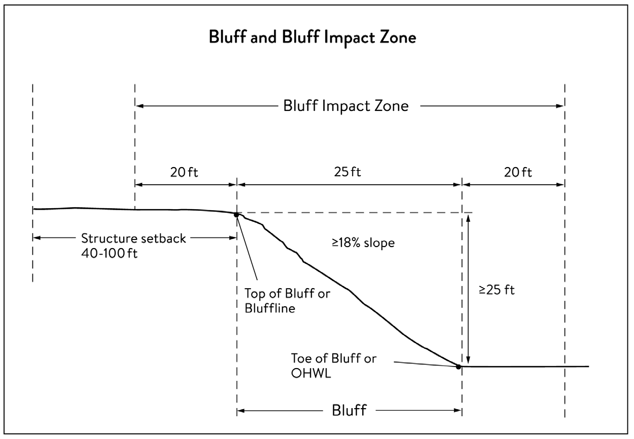
b.
A natural escarpment or cliff with a slope that rises at least ten (10) feet above the ordinary high water level or toe of the slope, whichever is applicable, to the top of the slope, with a slope of seventy-five (75) degrees or greater. See Figure 535-3, Natural Escarpment Bluff and Bluff Impact Zone.
Figure 535-3 Natural Escarpment Bluff and Bluff Impact Zone
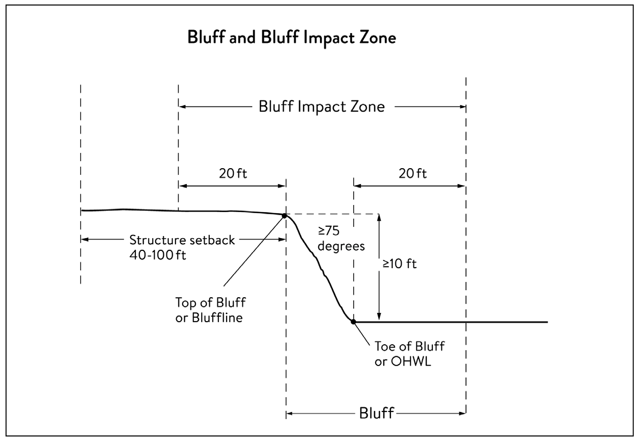
Bluff impact zone (BIZ). A bluff and land located within twenty (20) feet of the bluff. See Figures 535-2 and 535-3.
Bluffline. A line delineating the top of the bluff. More than one (1) bluffline may be encountered proceeding landward from the river. See Figures 535-2 and 535-3.
Bluff, Toe of. A line along the bottom of a bluff, requiring field verification, such that the slope above the line exceeds eighteen (18) percent and the slope below the line is eighteen (18) percent or less, measured over a horizontal distance of twenty-five (25) feet. See Figures 535-2 and 535-3.
Bluff, Top of. A line along the top of a bluff, requiring field verification, such that the slope below the line exceeds eighteen (18) percent and the slope above the line is eighteen (18) percent or less, measured over a horizontal distance of twenty-five (25) feet. See Figures 535-2 and 535-3.
Buildable area. The area of a lot or parcel upon which structures may be placed which excludes areas needed to meet requirements for setback, rights-of-way, bluff impact zones, historic properties, wetlands, designated floodways, land below the ordinary high-water level of public waters, and other unbuildable areas.
Building. A structure with two (2) or more outside rigid walls and a fully secured roof that is affixed to a permanent site.
Certificate of compliance. A document written after a compliance inspection, certifying that the development is in compliance with applicable requirements at the time of the inspection.
Commissioner. The commissioner of the Minnesota Department of Natural Resources.
Conditional use. A use having the meaning given under Minn. Statutes, Chapter 462.
Conservation design. A pattern of subdivision that is characterized by grouping lots within a portion of a parcel, where the remaining portion of the parcel is permanently protected as open space.
Conventional subdivision. A pattern of subdivision that is characterized by lots that are spread regularly throughout a parcel in a lot and block design.
Deck. A horizontal, unenclosed, aboveground level structure open to the sky, with or without attached railings, seats, trellises, or other features, attached or functionally related to a principal use or site.
Developer. Having the meaning given under Minn. Statutes, Section 116G.03.
Development. Having the meaning given under Minn. Statutes, Section 116G.03.
Discretionary action. An action under this chapter related to land use that requires a public hearing by local ordinance or statute, such as preliminary plats, final subdivision plats, planned unit developments, conditional use permits, interim use permits, variances, appeals, and rezonings.
Dock. Having the meaning given under Minnesota Rules, Chapter 6115.
Electric power facilities. Equipment and associated facilities for generating electric power or devices for converting wind energy to electrical energy as identified and defined under Minn. Statutes, Chapter 216E.
Essential services. Underground or overhead gas, electrical, communications, steam, or water distribution, collection, supply, or disposal systems, including storm water. Essential services include poles, wires, mains, drains, pipes, conduits, cables, fire alarm boxes, traffic signals, hydrants, navigational structures, aviation safety facilities or other similar equipment and accessories in conjunction with the systems. Essential services does not include buildings, treatment works as defined in Minn. Statutes, Section 115.01, electric power facilities or transmission services.
Floodplain. Having the meaning given under Minnesota Rules Chapter 6120.
Full cutoff luminaire. The luminous intensity (in candelas) at or above an angle of ninety (90) degrees above nadir is zero (0), and the luminous intensity (in candelas) at or above a vertical angle of eighty (80) degrees above nadir does not numerically exceed ten (10) percent of the luminous flux (in lumens) of the lamp or lamps in the luminaire.
Fully reconstruct. The reconstruction of an existing impervious surface that involves site grading and subsurface excavation so that soil is exposed. Mill and overlay and other resurfacing activities are not considered fully reconstructed.
Fully shielded luminaire. A luminaire constructed and installed in such a manner that all light emitted by the luminaire, either directly from the lamp or a diffusing element, or indirectly by reflection or refraction from any part of the luminaire, is projected below the horizontal plane through the luminaire's lowest light-emitting part.
Hard-surface trail. A trail surfaced in asphalt or other hard surface, for multipurpose use, as determined by local, regional, or state agency plans.
Historic property. An archaeological site, standing structure, site, district, or other property that is:
(1)
Listed in the National Register of Historic Places or the State Register of Historic Places or locally designated as a historic site under Minn. Statutes, Chapter 471;
(2)
Determined to meet the criteria for eligibility to the National Register of Historic Places or the State Register of Historic Places as determined by the director of the Minnesota Historical Society; or
(3)
An unplatted cemetery that falls under the provisions of Minn. Statutes, Chapter 307, in consultation with the Office of the State Archaeologist.
Impervious surface. A constructed hard surface that either prevents or retards the entry of water into the soil and causes water to run off the surface in greater quantities and at an increased rate of flow than prior to development. Examples include rooftops, decks, sidewalks, patios, parking lots, storage areas, and driveways, including those with concrete, asphalt, or gravel surfaces.
Intensive vegetation clearing. The removal of all or a majority of the trees or shrubs in a contiguous patch, strip, row, or block.
Interim use. A use having the meaning given under Minn. Statutes, Chapter 462.
Land alteration. An activity that exposes the soil or changes the topography, drainage, or cross section of the land, excluding gardening or similar minor soil disturbances.
Local government. Counties, cities, and townships.
Local park agencies. The Minneapolis Park and Recreation Board and the Three Rivers Park District.
Lot. Having the meaning given under Minnesota Rules Chapter 6120.
Lot width. The shortest distance between lot lines measured at both the ordinary high water level and at the required structure setback from the ordinary high water level. See Figure 535-4, Lot Width.
Figure 535-4 Lot Width
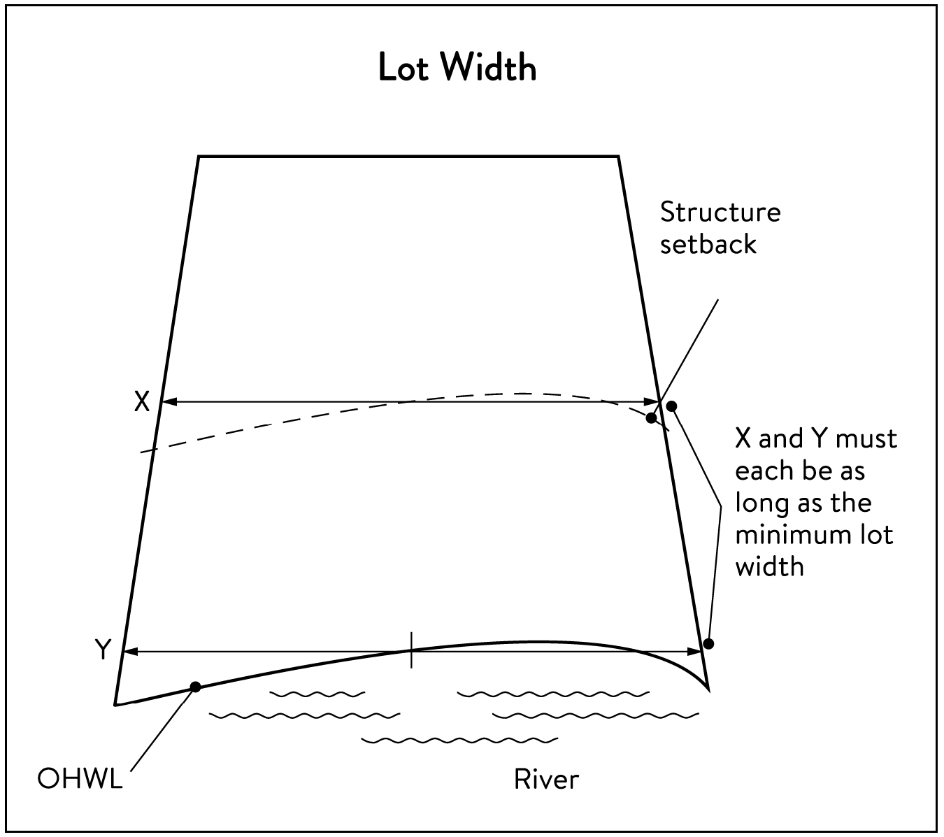
Luminaire. The complete lighting unit (fixture), consisting of a lamp, or lamps and ballast(s) (when applicable), together with the parts designed to distribute the light (reflector, lens, diffuser), to position and protect the lamps, and to connect the lamps to the power supply.
Marina. Having the meaning given under Minnesota Rules Chapter 6115.
Mississippi Flyway. The Mississippi Flyway is a major North American bird migration corridor for more than three hundred twenty-five (325) bird species that make the round trip each year from their breeding grounds in Canada and the northern United States to their wintering grounds along the Gulf of Mexico and in Central and South America. The Mississippi Flyway encompasses the entire MRCCA.
Mississippi River Corridor Critical Area (MRCCA). The area within the River Corridor Boundary.
Mississippi River Corridor Critical Area (MRCCA) Plan. A chapter or other element in the City of Minneapolis comprehensive plan.
Mooring facility. Having the meaning given under Minnesota Rules Section 6115.0170.
Native plant community. A plant community that has been identified as part of the Minnesota Biological Survey or biological survey issued or adopted by a local, state, or federal agency.
Natural-surface trail. A trail composed of native soil and rock or compacted granular stone, primarily intended for hiking, equestrian, or mountain bike use, as determined by local, regional, or state agency plans.
Natural vegetation. Any combination of ground cover, understory, and tree canopy that, while it may have been altered by human activity, continues to stabilize soils, retain and filter runoff, provide habitat, and recharge groundwater.
Nonconformity. Having the meaning given under Minn. Statutes, Section 462.357.
Nonmetallic mining. Construction, reconstruction, repair, relocation, expansion, or removal of any facility for the extraction, stockpiling, storage, disposal, or reclamation of nonmetallic minerals such a stone, sand, and gravel. Nonmetallic mining does not include ancillary facilities such as access roads, bridges, culverts, and water level control structures. For purposes of this subpart, "facility" includes all mine pits, quarries, stockpiles, basins, processing structures and equipment, and any structures that drain or divert public waters to allow mining.
Off-premises advertising signs. Those signs that direct attention to a product, service, business, or entertainment venue that is not exclusively related to the premises where the sign is located.
Ordinary high water level (OHWL). Having the meaning given under Minn. Statutes, Section 103G.005.
Parcel. Having the meaning given under Minn. Statutes, Section 116G.03.
Patio. A constructed hard surface located at ground level with no railings and open to the sky.
Picnic shelter. A roofed structure open on all sides, accessory to a recreational use.
Planned unit development. A method of land development that provides for flexibility in the use of land and the placement and size of buildings in order to better utilize the special features of sites and to obtain a higher quality of development that incorporates high levels of amenities than might otherwise occur under the strict application of zoning regulations for the users of the site, the neighborhood, or the city as a whole, and which meets public objectives for protection and preservation of natural and historic features as detailed in Chapter 550, Article VII, Planned Unit Development Standards.
Plat. Having the meaning given under Minn. Statutes, Chapters 505 and 515B.
Port. A water transportation complex established and operated under the jurisdiction of a port authority according to Minn. Statutes, Chapter 458.
Primary conservation areas. Key resources and features, including shore impact zones, bluff impact zones, floodplains, wetlands, gorges, areas of confluence with tributaries, natural drainage routes, unstable soils and bedrock, native plant communities, cultural and historic properties, and significant existing vegetative stands, tree canopies, and other resources identified in local government plans.
Private facilities. Private roads, driveways, and parking areas, private water access and viewing facilities, decks and patios in setback areas, and private signs.
Professional engineer. An engineer licensed to practice in Minnesota.
Public facilities. Public utilities, public transportation facilities, and public recreational facilities.
Public recreation facilities. Recreational facilities provided by the state or a local government and dedicated to public use, including parks, scenic overlooks, observation platforms, trails, docks, fishing piers, picnic shelters, water access ramps, and other similar water-oriented public facilities used for recreation.
Public river corridor views. Views toward the river from public parkland, historic properties, and public overlooks, as well as views toward bluffs from the ordinary high water level of the opposite shore, as seen during the summer months and documented in the MRCCA Plan/chapter of the comprehensive plan.
Public transportation facilities. All transportation facilities provided by federal, state, or local government and dedicated to public use, such as roadways, transit facilities, railroads, and bikeways.
Public utilities. Electric power facilities, essential services, and transmission services.
Public waters. Having the meaning given under Minn. Statutes, Section 103G.005.
Readily visible. Land and development that are easily seen from the ordinary high water level of the opposite shore during summer months.
Resource agency. A federal, state, regional, or local agency that engages in environmental, natural, or cultural resource protection or restoration activities, including planning, implementation, and monitoring.
Retaining wall. A vertical or nearly vertical structures constructed of mortar and rubble masonry, rock, or stone regardless of size, vertical timber pilings, horizontal timber planks with piling supports, sheet pilings, poured concrete, concrete blocks, or other durable materials.
River corridor boundary. The boundary approved and adopted by the Metropolitan Council under Minn. Statutes, Section 116G.06, as approved and adopted by the legislature in Minn. Statutes, Section 116G.15, and as legally described in the State Register, volume 43, pages 508 to 518.
River-dependent use. The use of land for commercial, industrial, or utility purposes, where access to and use of a public water feature is an integral part of the normal conduct of business and where the use is dependent on shoreline facilities.
Rock riprap. Natural coarse rock placed or constructed to armor shorelines, streambeds, bridge abutments, pilings and other shoreline structures against scour, or water or ice erosion.
Selective vegetation removal. The removal of isolated individual trees or shrubs that are not in a contiguous patch, strip, row, or block and that does not substantially reduce the tree canopy or understory cover.
Setback. A separation distance measured horizontally.
Shore impact zone (SIZ). Land located between the ordinary high water level of public waters and a line parallel to it at a setback of fifty (50) percent of the required structure setback or, for agricultural use, fifty (50) feet landward of the ordinary high water level. See Figure 535-5, Shore Impact Zone.
Figure 535-5 Shore Impact Zone
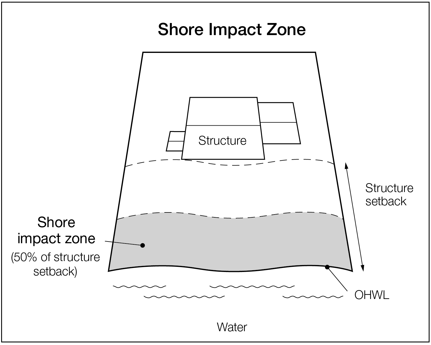
Shoreline facilities. Facilities that require a location adjoining public waters for ingress and egress, loading and unloading, and public water intake and outflow, such as barge facilities, port facilities, commodity loading and unloading equipment, watercraft lifts, marinas, short-term watercraft mooring facilities for patrons, and water access ramps. Structures that would be enhanced by a shoreline location, but do not require a location adjoining public waters as part of their function, are not shoreline facilities, such as restaurants, bait shops, and boat dealerships.
Special purpose units of government. The University of Minnesota, the St. Paul Port Authority, watershed management organizations established under Minn. Statutes, Chapter 103B, watershed districts established under Minn. Statutes, Chapter 103D, and any other unit of government other than local government or a state or regional agency.
State or regional agency. The Metropolitan Airports Commission, Minnesota Historical Society, University of Minnesota, Department of Natural Resources, Department of Transportation, Metropolitan Council and other state agencies.
Steep slope, critical area. A natural topographic feature with an average slope of twelve (12) to eighteen (18) percent, measured over a horizontal distance equal to or greater than fifty (50) feet, and any slopes greater than eighteen (18) percent that are not bluffs.
Storm water management facilities. Facilities for the collection, conveyance, treatment, or disposal of storm water.
Structure. A building, sign, or appurtenance thereto, except for aerial or underground utility lines, such as sewer, electric, telephone, or gas lines, and utility line towers, poles, and other supporting appurtenances.
Subdivision. Having the meaning given under Minn. Statutes, Section 462.352.
Subsurface sewage treatment system. Having the meaning given under Minnesota Rules, part 7080.1100.
Transmission services.
a.
Electric power lines, cables, pipelines, or conduits that are:
1.
Used to transport power between two (2) points, as identified and defined under Minn. Statutes, Section 216E.01, subdivision 4; or
2.
For mains or pipelines for gas, liquids, or solids in suspension, used to transport gas, liquids, or solids in suspension between two (2) points; and
b.
Telecommunication lines, cables, pipelines, or conduits.
Treeline. The more or less continuous line formed by the tops of trees in a wooded area when viewed from a particular point. The treeline is determined during all seasons as if under full foliage.
Variance. Having the meaning given under Minn. Statutes, Section 462.357, subdivision 6.
Water access ramp. A boat ramp, carry-down site, boarding dock, and approach road, or other access that allows launching and removal of a boat, canoe, or other watercraft with or without a vehicle and trailer.
Water-oriented accessory structure. A small building or other improvement, except stairways, fences, docks, and retaining walls, that, because of the relationship of its use to public waters, needs to be located closer to public waters than the normal structure setback. Examples include gazebos, screen houses, fish houses, pump houses, and detached decks and patios.
Water quality impact zone. Land within the shore impact zone or within fifty (50) feet of the OWHL of the river, whichever is greater, and land within fifty (50) feet of a public water, wetland, or natural drainage route.
Wetland. Having the meaning given under Minn. Statutes, Section 103G.005.
Wharf. Having the meaning given under Minnesota Rules, part 6115.0170.
535.1620. - Administration.
(a) Permits. A permit is required for the construction of buildings or building additions (including construction of decks and signs), the installation and/or alteration of sewage treatment systems, vegetation removal consistent with section 535.1690 and land alterations consistent with section 535.1700.
(b)
Variances. Variances to the requirements of this article may only be granted in accordance with Minn. Statutes, Section 462.357 and must consider the potential impacts of variances on primary conservation areas, public river corridor views, and other resources identified in the MRCCA Plan. In reviewing the variance application, the planning commission or zoning board of adjustment shall make the required findings for a variance pursuant to Chapter 525, Administration and Procedures, and further shall:
(1)
Evaluate the impacts to these resources and, if negative impacts are found, require conditions to mitigate the impacts that are related to and proportional to the impacts, consistent with section 535.1620(d); and
(2)
Make written findings that the variance is consistent with the purpose of this ordinance, as follows:
a.
The extent, location and intensity of the variance will be in substantial compliance with the MRCCA Plan;
b.
The variance is consistent with the character and management purpose of the MRCCA sub-district in which it is located;
c.
The variance will not be detrimental to PCAs and PRCVs nor will it contribute to negative incremental impacts to PCAs and PRCVs when considered in the context of past, present and reasonable future actions;
d.
The variance will not negatively impact other MRCCA Plan-identified resources; and
e.
The variance will not negatively impact birds and other wildlife using the Mississippi Flyway through habitat loss in identified PCAs and significant vegetation stands, collision threats, or light pollution in excess of the required lighting standards of this zoning ordinance.
(c)
Conditional and interim use permits. All conditional and interim uses required under this ordinance must comply with Minn. Statutes, Section 462.3595 or 462.3575, as applicable, and must consider the potential impacts on primary conservation areas, public river corridor views, and other resources identified in the MRCCA Plan. In reviewing the application, the planning commission shall:
(1)
Evaluate the impacts to these resources and if negative impacts are found, require conditions to mitigate the impacts that are related to and proportional to the impacts, consistent with section 535.1620(d); and
(2)
Make written findings that the conditional use is consistent with the purpose of this ordinance as follows:
a.
The extent, location and intensity of the conditional use will be in substantial compliance with the MRCCA Plan;
b.
The conditional use is consistent with the character and management purpose of the MRCCA sub-district in which it is located;
c.
The conditional use will not be detrimental to PCAs and PRCVs nor will it contribute to negative incremental impacts to PCAs and PRCVs when considered in the context of past, present and reasonable future actions;
d.
The conditional use will not negatively impact other MRCCA Plan-identified resources; and
e.
The conditional use permit will not negatively impact birds and other wildlife using the Mississippi Flyway through habitat loss in identified PCAs and significant vegetation stands, collision threats, or light pollution in excess of the required lighting standards of this zoning ordinance.
(d)
Conditions of approval. The planning commission or zoning board of adjustment shall evaluate the impacts to PCAs, PRCVs, and other resources identified in the MRCCA Plan, and if negative impacts are found, require conditions to mitigate the impacts that are related to and proportional to the impacts. Mitigation may include, but is not limited to:
(1)
Restoration of vegetation identified as "vegetation restoration priorities" identified in the MRCCA Plan;
(2)
Preservation of existing vegetation;
(3)
Stormwater runoff management;
(4)
Reducing impervious surface;
(5)
Increasing structure setbacks;
(6)
Wetland and drainage route restoration and/or preservation;
(7)
Increasing, enhancing, and/or connecting habitat for pollinators, birds, and other wildlife;
(8)
Increasing the minimum open space dedications in section 535.1710(c);
(9)
Techniques to minimize building bulk listed in section 535.1650(d);
(10)
Limiting the height of structures;
(11)
Modifying structure design to limit visual impacts on PRCVs; and
(12)
Other conservation measures.
(e)
Application materials. Applications for permits and discretionary actions required under this article must submit the following information unless the zoning administrator determines that the information is not needed:
(1)
A detailed project description;
(2)
Scaled maps and plans, dimensional renderings, and other materials that identify and describe:
a.
Primary conservation areas;
b.
Public river corridor views;
c.
Buildable area;
d.
Existing and proposed topography and drainage patterns;
e.
Proposed storm water and erosion and sediment control practices;
f.
Existing and proposed vegetation to be removed and established;
g.
Ordinary high water level, blufflines, and all required setbacks;
h.
Existing and proposed structures;
i.
Existing and proposed impervious surfaces; and
j.
Existing and proposed subsurface sewage treatment systems.
(f)
Nonconformities. All legally established nonconformities as of the date of this ordinance may continue, consistent with Minn. Statutes, Section 462.357 subdivision 1e and Chapter 545, Article VI, Nonconforming Uses and Structures.
(1)
New structures erected in conformance with the setback averaging provisions of section 535.1650(e)(4) are conforming structures.
(2)
Site alterations and expansion of site alterations that were legally made prior to the effective date of this ordinance are conforming. Site alterations include vegetation, erosion control, storm water control measures, and other nonstructural site improvements.
(3)
Legal nonconforming principal structures that do not meet the setback requirements of section 535.1650 may be expanded laterally provided that:
a.
The expansion does not extend into the shore or bluff impact zone or further into the required setback than the building line of the existing principal structure (see Figure 535-6, Expansion of Nonconforming Structure); and
b.
The expanded structure's scale and bulk is consistent with that of the original structure and existing surrounding development.
Figure 535-6 Expansion of Nonconforming Structure
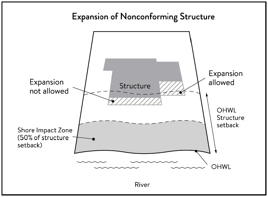
(g)
Notifications. Amendments to this article and to the MRCCA Plan shall be submitted to the commissioner as provided in Minnesota Rules, part 6106.0070, subpart 3, Items B-I.
(1)
Notice of public hearings for discretionary actions, including conditional and interim use permits, variances, appeals, rezonings, preliminary plats, final subdivision plats, and PUDs, shall be sent to the following entities at least twenty-one (21) days prior to the hearing:
a.
The commissioner in a format prescribed by the DNR;
b.
National Park Service; and
c.
Where proposed building heights exceed the height limit specified in section 535.1650(a) as part of a conditional use or variance process, adjoining local governments within the MRCCA, including those with overlapping jurisdiction and those across the river.
(2)
Notice of final decisions for actions, including findings of fact, must be sent to the Commissioner, the National Park Service, and adjoining local governments within the MRCCA within ten (10) days of the final decision.
(3)
Requests to amend district boundaries must follow the provisions in Minnesota Rules, part 6106.0100, subpart 9, Item C.
(h)
Accommodating disabilities. Reasonable accommodations for ramps or other facilities to provide persons with disabilities access to the persons' property, as required by the federal Americans with Disabilities Act and the federal Fair Housing Act and as provided by Minnesota Rules, Chapter 1341, must:
(1)
Comply with sections 535.1650 to 535.1720; or
(2)
If sections 535.1650 to 535.1720 cannot be complied with, ramps or other facilities are allowed with an administrative permit provided:
a.
The permit terminates on either a specific date or upon occurrence of a particular event related to the person requiring accommodation; and
b.
Upon expiration of the permit, the ramp or other facilities must be removed.
(Ord. No. 2025-023, § 17, 5-15-2025)
535.1630. - MRCCA Sub-Districts.
(a) District description and management purpose. The MR Overlay District within the City of Minneapolis is divided into the following sub-districts:
(1)
Rural and Open Space (ROS).
a.
Description. The ROS District is characterized by rural and low-density development patterns and land uses. It includes land that is riparian or visible from the river as well as large, undeveloped tracts of high ecological and scenic value, floodplain, and undeveloped islands. Many primary conservation areas exist in the ROS District.
b.
Management purpose. The ROS District shall be managed to sustain and restore the rural and natural character of the corridor and to protect and enhance habitat, parks and open space, public river corridor views, and scenic, natural, and historic areas.
(2)
River Neighborhood (RN).
a.
Description. The RN District is characterized by primarily residential neighborhoods that are riparian or readily visible from the river or that abut riparian parkland. The district includes parks and open space, limited commercial development, marinas, and related land uses.
b.
Management purpose. The RN District shall be managed to maintain the character of the river corridor within the context of existing residential and related neighborhood development, and to protect and enhance habitat, parks and open space, public river corridor views, and scenic, natural, and historic areas. Minimizing erosion and the flow of untreated storm water into the river and enhancing habitat and shoreline vegetation are priorities in the district.
(3)
River Towns and Crossings (RTC).
a.
Description. The RTC District is characterized by historic downtown areas and limited nodes of intense development at specific river crossings, as well as institutional campuses that predate designation of the MRCCA, and that include taller buildings.
b.
Management purpose. The RTC District shall be managed in a manner that allows continued growth and redevelopment in historic downtowns and more intensive redevelopment in limited areas at river crossings to accommodate compact walkable development patterns and connections to the river. Minimizing erosion and the flow of untreated storm water into the river, providing public access to and public views of the river, and restoring natural vegetation in riparian areas and tree canopy are priorities in the district.
(4)
Separated from River (SR).
a.
Description. The SR District is characterized by its physical and visual distance from the Mississippi River. The district includes land separated from the river by distance, topography, development, or a transportation corridor. The land in this district is not readily visible from the Mississippi River.
b.
Management purpose. The SR District provides flexibility in managing development without negatively affecting the key resources and features of the river corridor. Minimizing negative impacts to primary conservation areas and minimizing erosion and flow of untreated storm water into the Mississippi River are priorities in the district.
(5)
Urban Mixed (UM).
a.
Description. The UM District includes large areas of highly urbanized mixed-use that are a part of the urban fabric of the river corridor, including institutional, commercial, industrial, and residential areas and parks and open space.
b.
Management purpose. The UM District shall be managed in a manner that allows for future growth and potential transition of intensely developed areas that does not negatively affect public river corridor views and that protects bluffs and floodplains. Restoring and enhancing bluff and shoreline habitat, minimizing erosion and flow of untreated storm water into the river, and providing public access to and public views of the river are priorities in the district.
(6)
Urban Core (UC).
a.
Description. The UC District includes downtown.
b.
Management purpose. The UC District shall be managed with the greatest flexibility to protect commercial, industrial, and other high-intensity urban uses, while minimizing negative impacts to primary conservation areas and minimizing erosion and flow of untreated storm water into the river. Providing public access to and public views of the river are priorities in the district.
(b)
MR Overlay District map. The locations and boundaries of the MR Overlay District and sub-districts established by this ordinance are shown on the Mississippi River Corridor Critical Area Overlay District map which is incorporated herein by reference. The district boundary lines are intended to follow the center lines of rivers and streams, highways, streets, lot lines, and municipal boundaries, unless a boundary line is otherwise indicated on the map. Where district boundaries cross unsubdivided property, the district boundary line is determined by use of dimensions or the scale appearing on the map.
535.1640. - Special land use provisions.
(a) Underlying zoning. Uses within the MR Overlay District are generally determined by underlying zoning, with additional provisions for the following land uses:
(1)
Agricultural use. Perennial ground cover is required within fifty (50) feet of the ordinary high water level and within the bluff impact zone.
(2)
River-dependent uses. River-dependent uses must comply with the following design standards:
a.
Structures and parking areas, except shoreline facilities and private roads and conveyances serving river-dependent uses as provided in section 535.1720, must meet the dimensional and performance standards in [this] article, must be designed so that they are not readily visible, and must be screened by establishing and maintaining natural vegetation;
b.
Shoreline facilities must comply with Minnesota Rules, Chapter 6115 and must:
1.
Be designed in a compact fashion so as to minimize the shoreline area affected; and
2.
Minimize the surface area of land occupied in relation to the number of watercraft or barges to be served.
c.
Dredging and placement of dredged material are subject to existing federal and state permit requirements and agreements.
(3)
Wireless communication towers. Wireless communication towers require a conditional use permit and are subject to the following design standards:
a.
The applicant must demonstrate that functional coverage cannot be provided through co-location, a tower at a lower height, or a tower at a location outside of the MR Overlay District;
b.
The tower shall not be located in a bluff or shore impact zone;
c.
Placement of the tower shall minimize impacts on public river corridor views; and
d.
The tower design shall comply with the general design standards in section 535.1670(a) and the requirements of Chapter 550, Article XI, Communication Towers, Antennas, and Base Units.
535.1650. - Structure height and placement and lot size.
(a) Structure height. Structures and facilities must comply with the following maximum height standards unless identified as exempt in section 535.1720.
(1)
ROS District: Thirty-five (35) feet.
(2)
RN District: Thirty-five (35) feet.
(3)
RTC District: Forty-eight (48) feet provided tiering of structures away from the Mississippi River and from blufflines is given priority, with lower structure heights closer to the river and bluff lines, and that structure design and placement minimizes interference with public river corridor views.
(4)
SR District: Height is determined by underlying built form overlay zoning, provided the allowed height is consistent with that of the mature treeline, where present, and existing surrounding development, as viewed from the OWHL of the opposite shore.
(5)
UM1 District: Thirty-five (35) feet, provided tiering of structures away from the Mississippi River and from bluff lines is given priority, with lower structure heights closer to the river and blufflines, and that structure design and placement minimize interference with public river corridor views.
(6)
UM2 District: Fifty-six (56) feet, provided tiering of structures away from the Mississippi River and from bluff lines is given priority, with lower structure heights closer to the river and blufflines, and that structure design and placement minimize interference with public river corridor views.
(7)
UM3 District: Sixty-five (65) feet, provided tiering of structures away from the Mississippi River and from bluff lines is given priority, with lower structure heights closer to the river and blufflines, and that structure design and placement minimize interference with public river corridor views.
(8)
UC District: Height is determined by underlying built form overlay zoning, provided tiering of structures away from the Mississippi River and bluff lines is given priority, with lower structure heights closer to the river and blufflines, and structure design and placement minimize interference with public river corridor views.
(b)
Height is measured as defined by the Minneapolis Zoning Ordinance for compliance with built form overlay district requirements and also on the side of the structure facing the Mississippi River for compliance with the MRCCA sub-districts. The more restrictive requirement shall apply. For the purpose of determining a minimum required yard where such yard is based on a structure's height, the method of determining the height of a principal structure shall be identical to the method used for properties located outside of the MR Overlay District.
(c)
Increasing maximum height. Height increases may be requested, subject to the following provisions:
(1)
The maximum height requirement of accessory structures may be increased only by variance, as specified in Chapter 525, Administration and Procedures, and subject to the provisions of this chapter.
(2)
Except for accessory structures, where an increase in height exceeds the maximum height requirement of the built form overlay district, but not the MR Overlay District, the height may be increased as allowed in the built form overlay district, as specified in Chapter 540, Built Form Overlay Districts, up to the maximum height requirement of the MR Overlay District.
(3)
Except for accessory structures, where an increase in height exceeds the maximum height requirements of both the built form overlay district and MR Overlay District, the height increase is subject to both the standards for increasing maximum height in the built form overlay district, as specified in Chapter 540, Built Form Overlay Districts, and a variance of the MR Overlay District maximum height requirements in the CA-ROS and CA-RN Districts or a conditional use permit in the CA-RTC and CA-UM Districts.
(4)
Except for accessory structures, where an increase in maximum height exceeds the maximum height requirements of the MR Overlay District, but not the maximum height requirements of the built form overlay district, the height increase is subject to a variance of the MR Overlay District requirements in the CA-ROS and CA-RN Districts or a conditional use permit in the CA-RTC and CA-UM Districts.
(5)
Except for accessory structures, height increases in the CA-SR and CA-UC Districts are determined by the standards for increasing height in the underlying built form overlay districts, as specified in Chapter 540, Built Form Overlay Districts. The SH Shoreland Overlay District maximum height limits do not apply to the CA-SR and CA-UC Districts.
(d)
In addition to the applicable height increase requirements and findings of Chapter 540, Built Form Overlay Districts, and of section 535.1620(c), criteria for considering whether to grant a conditional use permit for structures exceeding the height limits shall include:
(1)
Assessment of the visual impact of the proposed structure on public river corridor views, including views from other communities.
(2)
Determination that the proposed structure meets the required bluff and OHWL setbacks; where a variance of the bluff or OHWL setback is requested provision of a mitigation plan that mitigates any negative impacts.
(3)
Identification and application of techniques to minimize the perceived bulk of the proposed structure, such as:
a.
Placing the long axis of the building perpendicular to the river;
b.
Stepping back of portions of the facade;
c.
Lowering the roof pitch or use of a flat roof;
d.
Using building materials or mitigation techniques that will blend in with the natural surroundings such as green roofs, green walls, or other green building materials;
e.
Narrowing the profile of upper floors of the building; or
f.
Increasing the setbacks of the building from the Mississippi River or blufflines;
g.
Identification of techniques for preservation of those view corridors identified in the MRCCA Plan; and
h.
Opportunities for creation or enhancement of public river corridor views; and
i.
Compliance with Minnesota B3 Guidelines, version 3.2, Site and Water Guidelines: S.5 Animal Habitat Support.
(e)
Structure and impervious surface placement.
(1)
Structures and impervious surfaces must not be placed in the shore or bluff impact zones, unless exempted in section 535.1720.
(2)
Structures and facilities must comply with the following minimum OHWL setback provisions unless exempted in section 535.1720.
a.
ROS District: Two hundred (200) feet.
b.
RN District: One hundred (100) feet.
c.
RTC District: Seventy-five (75) feet.
d.
UM District: Fifty (50) feet.
e.
UC District: As per underlying zoning.
(3)
Structures and facilities must comply with the following minimum bluffline setback provisions unless exempted in section 535.1720:
a.
ROS District: One hundred (100) feet.
b.
RN District: Forty (40) feet.
c.
RTC District: Forty (40) feet.
d.
SR District: Forty (40) feet.
e.
UM District: Forty (40) feet.
f.
UC District: Forty (40) feet.
(4)
Where principal structures exist on the adjoining lots on both sides of a proposed building site, the minimum setback may be altered to conform to the average of the adjoining setbacks, provided that the new structure's scale and bulk riverward or bluffward of the setbacks required under sections 535.1650(d)(2) and (3) are consistent with adjoining development. See Figure 535-7, Structure Setback Averaging.
Figure 535-7 Structure Setback Averaging
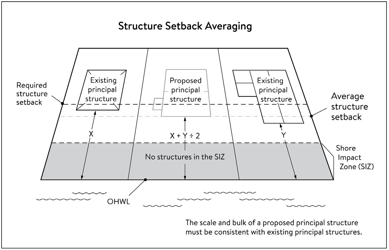
(f)
Lot size and buildable area.
(1)
The width of lots abutting the Mississippi River in the ROS District must be at least two hundred (200) feet, unless alternative design methods are used that provide greater protection of the riparian area.
(2)
All new lots must have adequate buildable area to comply with the setback requirements of sections 535.1650(d)(2) and (3) without requiring variances to use the lots for their intended purpose.
535.1660. - Performance standards for private facilities.
(a) General design standards. All private facilities must be developed in accordance with the vegetation management and land alteration requirements in sections 535.1690 and 535.1700.
(b)
Private roads, driveways, and parking areas. Except as provided in section 535.1720, private roads, driveways and parking areas must:
(1)
Be designed to take advantage of natural vegetation and topography so that they are not readily visible;
(2)
Comply with structure setback requirements according to section 535.1650(d); and
(3)
Not be placed within the bluff impact zone or shore impact zone, unless exempt under section 535.1720 and designed consistent with section 535.1670(a).
(c)
Private water access and viewing facilities.
(1)
Private access paths must be no more than:
a.
Eight (8) feet wide, if placed within the shore impact zone; and
b.
Four (4) feet wide, if placed within the bluff impact zone.
(2)
Private water access ramps must:
a.
Comply with Minnesota Rules, Chapters 6115.0210 and 6280.0250; and
b.
Be designed and constructed consistent with the applicable standards in Design Handbook for Recreational Boating and Fishing Facilities.
(3)
Design and construction of private stairways, lifts, and landings are subject to the following standards:
a.
Stairways and lifts must not exceed four (4) feet in width on residential lots. Stairways shall not exceed six (6) feet in width for commercial properties and residential facilities held in common;
b.
Landings for stairways and lifts on residential lots must not exceed thirty-two (32) square feet in area. Landings for commercial properties and residential facilities held in common shall not exceed forty-eight (48) square feet in area;
c.
Canopies or roofs are prohibited on stairways, lifts, or landings;
d.
Stairways, lifts, and landings must be located in the least visible portion of the lot whenever practical; and
e.
Ramps, lifts, mobility paths, or other facilities for persons with physical disabilities are allowed for achieving access to shore areas according to clauses a.—d. above, and as provided under section 535.1620(h).
(4)
One (1) water-oriented accessory structure is allowed for each riparian lot or parcel less than three hundred (300) feet in width at the ordinary high water level, with one (1) additional water-oriented accessory structure allowed for each additional three hundred (300) feet of shoreline on the same lot or parcel. Water-oriented accessory structures are prohibited in the bluff impact zone and shall:
a.
Not exceed twelve (12) feet in height;
b.
Not exceed one hundred twenty (120) square feet in area; and
c.
Be placed a minimum of ten (10) feet from the ordinary high water level.
(d)
Decks and patios in setback areas. Decks and at-grade patios may encroach into the required setbacks from the ordinary high water level and bluff lines without a variance, when consistent with sections 535.1690 and 535.1700, provided that:
(1)
The encroachment of the deck or patio into the required setback area does not exceed fifteen (15) percent of the required structure setback;
(2)
The area of the deck or patio that extends into the required setback area occupies no more than twenty-five (25) percent of the total area between the required setback and the fifteen (15) percent using the formula: [required setback depth (feet) × 0.15 × lot width at setback (feet) x 0.25 = maximum total area]
(3)
The deck or patio does not extend into the bluff impact zone. See Figure 535-8, Deck and Patio Encroachment.
Figure 535-8 Deck and Patio Encroachment
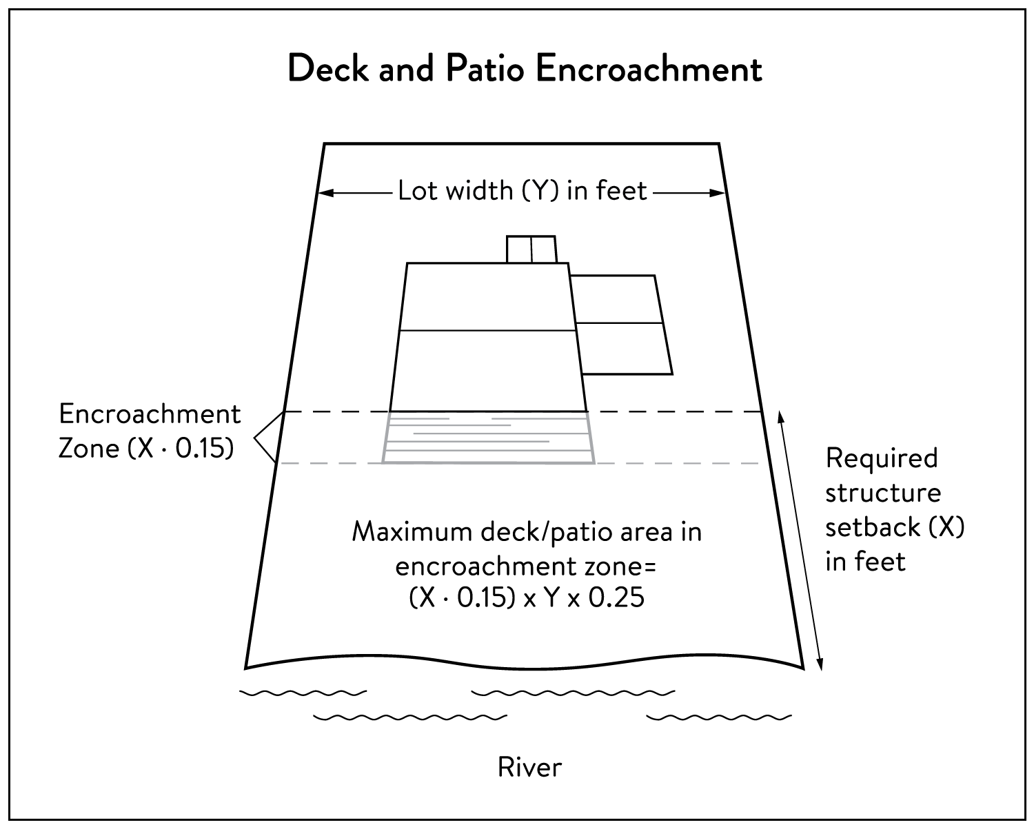
(e)
Off-premises and directional signs. Off-premises advertising signs and billboards, including the sign face and structure, which may be viewed from the Mississippi River shall be prohibited, except a sign or billboard designated by the Heritage Preservation Commission or determined by the Heritage Preservation Commission to be a contributing feature in a historic district.
Directional signs for patrons arriving at a business by watercraft must comply with the following standards:
(1)
They must be consistent with Minn. Statutes, Section 86B.115.
(2)
Only convey the location and name of the establishment and the general types of goods and services available, if located in a shore impact zone.
(3)
Meet the height and size requirements of Chapter 560, Signs, or be no greater than eight (8) feet in height and thirty-two (32) square feet in surface area, whichever is less.
(f)
Fences. Fences between principal structures and the river are permitted, provided the following standards are met:
(1)
Fences are subject to height and location requirements of Chapter 550, Article X, Fences. Fences shall not exceed six (6) feet in height.
(2)
Fences shall not be located within the shore impact zone or bluff impact zone.
(3)
Fences shall not be located in the regulatory floodplain.
(Ord. No. 2025-023, § 18, 5-15-2025)
535.1670. - Performance standards for public facilities.
(a) General design standards. All public facilities must be designed and constructed to:
(1)
Minimize visibility of the facility from the river to the extent consistent with the purpose of the facility;
(2)
Comply with the structure placement and height standards in section 535.1650, except as provided in section 535.1720;
(3)
Be consistent with the vegetation management standards in section 535.1690 and the land alteration and storm water management standards in section 535.1700, including use of practices identified in Best Practices for Meeting DNR General Public Waters Work Permit GP 2004-0001, where applicable;
(4)
Avoid primary conservation areas, unless no alternative exists. If no alternative exists, then disturbance to primary conservation areas must be avoided to the greatest extent practicable, and design and construction must minimize impacts;
(5)
Minimize disturbance of spawning and nesting times by scheduling construction at times when local fish, birds, and wildlife are not spawning or nesting; and
(6)
During bird migration times, schedule construction, or implement mitigation measures, to minimize disturbance in primary conservation areas.
(b)
Right-of-way maintenance standards. Right-of-way maintenance must comply with the following standards:
(1)
Vegetation currently in a natural state must be maintained to the extent feasible;
(2)
Where vegetation in a natural state has been removed, native plants should be considered for replanting and maintained on the right-of-way; and
(3)
Chemical control of vegetation must be avoided when practicable, but when chemical control is necessary, chemicals used must be in accordance with the regulations and other requirements of all state and federal agencies with authority over the chemical's use.
(c)
Crossings of public water or public land. Crossings of public waters or land controlled by the commissioner are subject to approval by the commissioner according to Minn. Statutes, Sections 84.415 and 103G.245.
(d)
Public utilities. Public utilities must comply with the following standards:
(1)
High-voltage transmission lines, wind energy conversion systems greater than five (5) megawatts, and pipelines are regulated according to Minn. Statutes, Chapters 216E, 216F, and 216G respectively; and
(2)
If overhead placement is necessary, utility facility crossings must minimize visibility of the facility from the river and follow other existing rights-of-way as much as practicable.
(3)
The appearance of structures must be as compatible as practicable with the surrounding area in a natural state with regard to height and width, materials used, and color.
(4)
Wireless communication facilities, according to section 535.1640(a)(3).
(e)
Public transportation facilities. Public transportation facilities shall comply with structure placement and height standards in section 535.1650. Where such facilities intersect or abut two (2) or more MRCCA sub-districts, the least restrictive standards apply. Public transportation facilities must be designed and constructed to give priority to:
(1)
Providing scenic overlooks for motorists, bicyclists, and pedestrians;
(2)
Providing safe pedestrian crossings and facilities along the river corridor;
(3)
Providing access to the riverfront in public ownership; and
(4)
Allowing for use of the land between the river and the transportation facility.
(f)
Public recreational facilities. Public recreational facilities must comply with the following standards:
(1)
Buildings and parking associated with public recreational facilities must comply with the structure placement and height standards in section 535.1650, except as provided in section 535.1720.
(2)
Roads and driveways associated with public recreational facilities must not be placed in the bluff or shore impact zones unless no other placement alternative exists. If no alternative exists, then design and construction must minimize impacts to shoreline vegetation, erodible soils and slopes, and other sensitive resources.
(3)
Trails, access paths, and viewing areas associated with public recreational facilities and providing access to or views of the Mississippi River are allowed within the bluff and shore impact zones if design, construction, and maintenance methods are consistent with the best management practice guidelines in Trail Planning, Design, and Development Guidelines.
a.
Hard-surface trails are not allowed on the face of bluffs with a slope exceeding thirty (30) percent. Natural surface trails are allowed, provided they do not exceed eight (8) feet in width.
b.
Trails, paths, and viewing areas must be designed and constructed to minimize:
1.
Visibility from the river;
2.
Visual impacts on public river corridor views; and
3.
Disturbance to and fragmentation of primary conservation areas.
(4)
Public water access facilities must comply with the following requirements:
a.
Watercraft access ramps must comply with Minnesota Rules Chapters 6115.0210 and 6280.0250; and
b.
Facilities must be designed and constructed consistent with the standards in Design Handbook for Recreational Boating and Fishing Facilities.
(5)
Public signs and kiosks for interpretive or directional purposes are allowed in the bluff or shore impact zones, provided they are placed and constructed to minimize disturbance to these areas and avoid visual impacts on public river corridor views. Sign size, height, and type shall be as regulated in the base zoning district.
(6)
Public stairways, lifts, and landings must be designed as provided in section 535.1660(c)(3).
535.1680. - Performance standards for exterior lighting.
(a) Exterior lighting standards. In addition to the lighting standards in section 550.2230 of this zoning ordinance, all exterior lighting within the MR Overlay District must comply with the following standards:
(1)
Luminaires must be full-cutoff or fully shielded. See Figure 535-9, Examples of Fully Shielded and Cutoff Luminaires.
(2)
Uplighting is not permitted.
(3)
For structures other than single- and two-family dwellings, and three-family dwellings architectural accent, ornamental, or decorative lighting is not permitted, unless otherwise allowed by conditional use permit.
Figure 535-9 Examples of Fully Shielded and Cutoff Luminaires
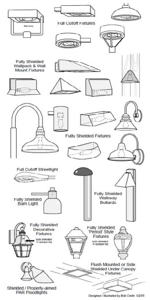
(b)
Conditional use permits and exemptions.
(1)
Architectural lighting, other than uplighting, of buildings and architectural accent, ornamental, or decorative lighting may be allowed by conditional use permit, provided the lighting is turned off from dusk to dawn between March 15 and May 31 and between August 15 and October 31 each year.
(2)
Lighting that is noncompliant with the standards of the section may be allowed by conditional use permit for public parks, athletic fields and outdoor recreation facilities serving or operated by an institutional or public use, and outdoor commercial recreation, entertainment and lodging uses, provided the lighting is related to and reasonably necessary for the operation of the use and that is turned off when the use is not in operation.
(3)
Lighting that is noncompliant with the standards of this section, may be allowed by the Heritage Preservation Commission for historic landmarks and districts when determined to be a contributing feature of a landmark or district. In addition, lighting of public facilities that is noncompliant with the standards of this section, may be allowed by the zoning administrator where required by federal and state historic regulations, guidelines, or environmental reviews. Were possible, lighting should be turned off from dusk to dawn between March 15 and May 31 and between August 15 and October 31 each year.
(4)
The following lighting is exempt from the provisions of this section:
a.
Publicly controlled or maintained emergency or traffic signals;
b.
Lighting for public monuments, statues, and bridges;
c.
Lighting required by federal or state laws or regulations;
d.
Emergency lighting;
e.
Flagpoles; and
f.
Motion-activated security lighting.
535.1690. - Vegetation management.
(a) Applicability. This section applies to:
(1)
Shore impact zones;
(2)
Areas within fifty (50) feet of a wetland or natural drainage route;
(3)
Bluff impact zones;
(4)
Areas of native plant communities; and
(5)
Significant existing vegetative stands identified in the MRCCA Plan.
(b)
Activities allowed without a vegetation permit.
(1)
Maintenance of existing lawns, landscaping and gardens;
(2)
Removal of vegetation in emergency situations as determined by the city;
(3)
Right-of-way maintenance for public facilities meeting the standards section 535.1670(b);
(4)
Agricultural activities meeting the standards of section 535.1640(a)(2);
(5)
Selective vegetation removal, provided that vegetative cover remains consistent with the management purpose of the MR Overlay District, including removal of:
a.
Vegetation that is dead, diseased and or infested, dying, or hazardous;
b.
To prevent the spread of diseases or insect pests;
c.
Individual trees and shrubs; and
d.
Invasive non-native species.
(c)
Activities allowed with a vegetation permit.
(1)
Only the following intensive vegetation clearing activities are allowed with a vegetation permit:
a.
Clearing of vegetation that is dead, diseased and or infested, dying, or hazardous.
b.
Clearing to prevent the spread of diseases or insect pests.
c.
Clearing to remove invasive non-native species.
d.
Clearing to prepare for restoration and erosion control management activities consistent with a plan approved by the City or Minneapolis Park and Recreation Board.
e.
The minimum necessary for development that is allowed with a building permit or as an exemption under section 535.1720.
(2)
General performance standards. The following standards must be met, in addition to a restoration plan under section 535.1690(e), in order to approve a vegetation permit:
a.
Development is sited to minimize removal of or disturbance to natural vegetation;
b.
Soil, slope stability, and hydrologic conditions are suitable for the proposed work as determined by a professional engineer;
c.
Clearing is the minimum necessary and designed to blend with the natural terrain and minimize visual impacts to public river corridor views;
d.
Any disturbance of highly erodible soils is replanted with deep-rooted vegetation with a high stem density;
e.
Vegetation removal activities are conducted so as to expose the smallest practical area of soil to erosion for the least possible time and to minimize disturbance during bird migration and nesting seasons; and
f.
Any other condition determined necessary to achieve the purpose of this section.
(d)
Prohibited activities. All other intensive vegetation clearing is prohibited.
(e)
Vegetation restoration plan.
(1)
Development of a vegetation restoration plan and reestablishment of natural vegetation is required:
a.
For any vegetation removal requiring a permit as identified in section 535.1690(c);
b.
Upon failure to comply with any provisions in this section; or
c.
As part of the planning process for subdivisions as provided in section 535.1710.
(2)
Restoration plan performance standards. The vegetation restoration plan must satisfy the application submittal requirements in section 535.1620(e), and the following:
a.
Vegetation must be restored in one (1) or more of the following restoration priority areas:
1.
Areas with soils showing signs of erosion, especially on or near the top and bottom of steep slopes and bluffs;
2.
Shoreline areas within twenty-five (25) feet of the water with no natural vegetation, degraded vegetation, or planted with turf grass;
3.
Areas on steep slopes and bluffs that are visible from the river with no natural vegetation, degraded vegetation, or planted with turf grass; or
4.
Other approved priority opportunity area, including priorities identified in the MRCCA Plan, if none of the above exist.
b.
Include vegetation that provides suitable habitat and effective soil stability, runoff retention, and infiltration capability. Vegetation species, composition, density, and diversity must be guided by nearby patches of native plant communities and by Native Vegetation Establishment and Enhancement Guidelines.
c.
Any highly erodible soils disturbed during removal and/or restoration must be stabilized with deep-rooted vegetation with a high stem density.
d.
Vegetation removed must be restored with native vegetation to the greatest extent practicable. The area (square feet) of the restored vegetation, and number of trees, should be similar to that removed to the greatest extent practicable.
e.
For restoration of removed native plant communities, restored vegetation must also provide biological and ecological function equivalent to the removed native plant communities. The area (square feet) of the restored vegetation should be equivalent to that removed.
f.
Be prepared by a qualified individual including a professional ecologist, arborist, landscape architect, or person with demonstrable experience and knowledge related to vegetation management.
g.
Include a maintenance plan that includes management provisions for controlling invasive species and replacement of plant loss for three (3) years.
(3)
A certificate of compliance will be issued after the vegetation restoration plan requirements have been satisfied.
535.1700. - Land alteration standards and stormwater treatment.
(a) Land alteration.
(1)
Within the bluff impact zone, land alteration is prohibited, except for the following which are allowed by permit:
a.
Erosion control consistent with a plan approved by the local government or resource agency and consistent with section 535.1700(e);
b.
The minimum necessary for development that is allowed as an exception under section 535.1720; and
c.
Repair and maintenance of existing buildings and facilities.
(2)
Within the water quality impact zone, land alteration that involves more than ten (10) cubic yards of material or affects an area greater than one thousand (1,000) square feet requires a permit.
(b)
Rock riprap, retaining walls, and other erosion control structures.
(1)
Construction, repair, or replacement of rock riprap, retaining walls, and other erosion control structures located at or below the OHWL must comply with Minnesota Rules, Chapters 6115.0215, subpart 4, item E, and 6115.0216, subpart 2. Work must not proceed until approved by the commissioner, permitted by the US Army Corps of Engineers, and any other permits are obtained. See Figure 535-10, Riprap Guidelines.
Figure 535-10 Riprap Guidelines
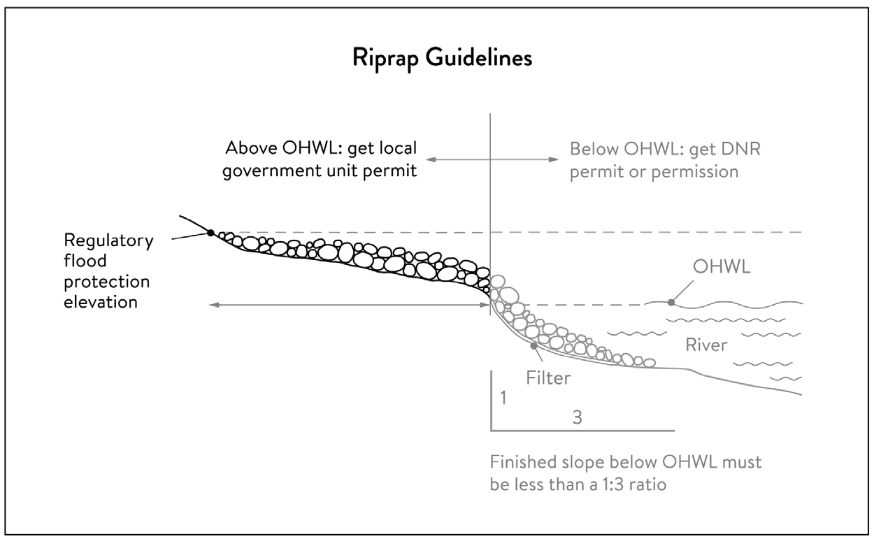
(2)
Construction or replacement of rock riprap, retaining walls, and other erosion control structures within the bluff impact zone and the water quality impact zone are allowed with a permit consistent with provisions of section 535.1700(e) provided that:
a.
If the project includes work at or below the OHWL, the commissioner has already approved or permitted the project.
b.
The structures are used only to correct an established erosion problem as determined by the watershed management organization.
c.
The size and extent of the structures are the minimum necessary to correct the erosion problem and are not larger than the following, unless a professional engineer determines that a larger structure is needed to correct the erosion problem:
1.
Retaining walls must not exceed five (5) feet in height and must be placed a minimum horizontal distance of ten (10) feet apart; and
2.
Riprap must not exceed the height of the regulatory flood protection elevation.
(3)
Repair of existing rock riprap, retaining walls, and other erosion control structures above the OHWL does not require a permit provided it does not involve any land alteration.
(c)
Stormwater management.
(1)
In the bluff impact zone, storm water management facilities are prohibited, except by permit if:
a.
There are no alternatives for storm water treatment outside the bluff impact zone on the subject site;
b.
The site generating runoff is designed so that the amount of runoff reaching the bluff impact zone is reduced to the greatest extent practicable;
c.
The construction and operation of the facility does not affect slope stability on the subject property or adjacent properties; and
d.
Mitigation based on the best available engineering and geological practices is required and applied to eliminate or minimize the risk of slope failure.
(2)
In the water quality impact zone, development that creates new impervious surface, as allowed by exemption in section 535.1720, or fully reconstructs existing impervious surface of more than ten thousand (10,000) square feet requires a storm water permit. Multipurpose trails and sidewalks are exempt if there is down gradient vegetation or a filter strip that is at least five (5) feet wide.
(3)
In all other areas, storm water runoff must be directed away from the bluff impact zones or unstable areas.
(d)
Development on critical area steep slopes. Construction of structures, impervious surfaces, land alteration, vegetation removal, or other construction activities are allowed on critical area steep slopes, if:
(1)
The development can be accomplished without increasing erosion or storm water runoff;
(2)
The soil types and geology are suitable for the proposed development; and
(3)
Vegetation is managed according to the requirements of section 535.1690.
(e)
Conditions of land alteration permit approval.
(1)
Temporary and permanent erosion and sediment control measures retain sediment onsite consistent with best management practices in the Minnesota Stormwater Manual;
(2)
Natural site topography, soil, and vegetation conditions are used to control runoff and reduce erosion and sedimentation;
(3)
Construction activity is phased when possible;
(4)
All erosion and sediment controls are installed before starting any land disturbance activity;
(5)
Erosion and sediment controls are maintained to ensure effective operation;
(6)
The proposed work is consistent with the vegetation standards in section 535.1690; and
(7)
Best management practices for protecting and enhancing ecological and water resources identified in Best Practices for Meeting DNR General Public Waters Work Permit GP 2004-0001.
(f)
Compliance with other plans and programs. All development must:
(1)
Be consistent with Minn. Statutes, Chapter 103B, and local water management plans completed under Chapter 8410;
(2)
Meet or exceed the wetland protection standards under Minnesota Rules, Chapter 8420; and
(3)
Meet or exceed the floodplain management standards under Minnesota Rules, Chapters 6120.5000—6120.6200.
535.1710. - Subdivision and land development standards.
(a) Applicability.
(1)
The design standards in this section apply to subdivisions, planned unit developments and master-planned development and redevelopment of land involving five (5) or more acres for contiguous parcels that abut the Mississippi River and five (5) or more acres for all other parcels, including smaller individual sites within the following developments that are part of a common plan of development that may be constructed at different times:
a.
Subdivisions;
b.
Planned unit developments; and
c.
Master-planned development and redevelopment of land.
(2)
The following activities are exempt from the requirements of this section:
a.
Minor subdivisions consisting of three (3) or fewer lots;
b.
Minor boundary line corrections;
c.
Resolutions of encroachments;
d.
Additions to existing lots of record; and
e.
Placement of essential services.
(b)
Application materials. Project information listed in section 535.1620(e) must be submitted for all proposed developments.
(c)
Design standards.
(1)
Primary conservation areas, where they exist, must be set aside and designated as protected open space in quantities meeting the following as a percentage of total parcel area:
a.
CA-ROS District: Fifty (50) percent;
b.
CA-RN District: Twenty (20) percent;
c.
CA-RTC, CA-UM, and CA-UC Districts: Ten (10) percent; and
d.
CA-SR District: Ten (10) percent if the parcel includes native plant communities or provides feasible connections to a regional park or trail system, otherwise no requirement.
(2)
If the primary conservation areas exceed the amounts specified in section 535.1710(c)(1) then protection of native plant communities and natural vegetation in riparian areas shall be prioritized.
(3)
If primary conservation areas exist but do not have natural vegetation (identified as restoration priorities in the MRCCA Plan), then a vegetation assessment must be completed to evaluate the unvegetated primary conservation areas and determine whether vegetation restoration is needed. If restoration is needed, vegetation must be restored according to section 535.1690(e).
(4)
If primary conservation areas do not exist on the parcel and portions of the parcel have been identified in the MRCCA Plan as a restoration area, vegetation must be restored in the identified areas according to section 535.1690(e) and the area must be set aside and designated as protected open space.
(5)
Storm water treatment areas or other green infrastructure may be used to meet the protected open space requirements if the vegetation provides biological and ecological functions.
(6)
Land dedicated under Title 22 Article V for public river access, parks, or other open space or public facilities may be counted toward the protected open space requirement.
(7)
Protected open space areas must connect open space, natural areas, and recreational areas, where present on adjacent parcels, as much as possible to form an interconnected network.
(d)
Permanent protection of designated open space.
(1)
Designated open space areas must be protected through one (1) or more of the following methods:
a.
Public acquisition by a government entity for conservation purposes;
b.
A permanent conservation easement, as provided in Minn. Statutes, Chapter 84C;
c.
A deed restriction; and
d.
Other arrangements that achieve an equivalent degree of protection.
(2)
Permanent protection methods must ensure the long-term management of vegetation to meet its biological and ecological functions, prohibit structures, and prohibit land alteration, except as needed to provide public recreational facilities and access to the river.
(e)
Alternative design standards. Alterative design standards may be considered through a planned unit development or cluster development. Individual lots in a planned unit development or cluster development are not required to meet the design standards of this section if it can be demonstrated that the overall development is in compliance with the standards and purpose of this section.
535.1720. - Exemptions.
(a) Applicability.
(1)
Uses and activities not specifically exempted must comply with this article. Uses and activities exempted under shore impact zone and bluff impact zone must comply with the vegetation management and land alteration standards in sections 535.1690 and 535.1700.
(2)
Uses and activities in Table 535-1 are categorized as:
a.
Exempt — E. This means that the use or activity is allowed;
b.
Exempt if no alternative — (E). This means that the use or activity is allowed only if the zoning administrator determines that no alternatives exist; and
c.
Not exempt — N. This means that a use or activity is not exempt and must meet the standards of this ordinance.
Table 535-1 Uses or Activities in the MR Overlay District