
Niles City Zoning Code
SECTION 7
- SPECIAL PURPOSE DISTRICTS
7.1 - PURPOSE STATEMENTS
A.
P-I Public/Institutional Lands District
The P-I Public/Institutional Lands District is intended to provide a zoning designation to accommodate public lands and institutions and quasi-public institutions within the Village.
B.
C-E Cannabis Establishment Overlay District
The C-E Cannabis Establishment Overlay District is intended to establish areas where Adult-Use Cannabis Craft Grower Organizations, Adult-Use Cannabis Dispensing Organizations, and Medical Cannabis Dispensing Organizations may be allowed within the Village.
(Ord. No. 2017-58, § 2(Exh. 1), 11-28-17; Ord. No. 2019-32, § 2, 10-8-19)
7.2 - P-I PUBLIC INSTITUTIONAL LANDS DISTRICT
A.
Uses
Section 8 lists permitted and special principal uses and temporary uses for the P-I District.
B.
Accessory Uses
Accessory uses, buildings, or other structures customarily incidental to and commonly associated with a principal use—either permitted or special—may be permitted, provided they are operated and maintained under the same ownership and on the same lot as the principal use, do not include structures or structural features inconsistent with the principal use, and do not involve the conduct of any business, profession, trade, or industry. The provisions of Sections 9.3 and 9.4 also apply.
C.
Dimensional Standards
Table 7-1: P-I District Dimensional Standards establishes the dimensional standards for the P-I District. These regulations apply to all uses within each district unless a different standard is listed for a specific use.
7.3 - GENERAL STANDARDS OF APPLICABILITY—P-I PUBLIC INSTITUTIONAL LANDS DISTRICT
A.
Site Development Standards
See Section 9 for additional on-site development standards and requirements, such as exterior lighting, accessory structures and uses, and permitted encroachments.
B.
Off-Street Parking and Loading
See Section 10 for off-street parking and loading standards and requirements.
C.
Landscape
See Section 11 for landscape, buffering and screening standards and requirements.
D.
Signs
See Chapter 78 of the Village Code for sign standards.
(Ord. No. 2019-32, § 2, 10-8-19)
Editor's note— Ord. No. 2019-32, § 2, adopted Oct. 8, 2019, changed the title of § 7.3 from "General Standards of Applicability" to read as herein set out.
7.4 - C-E CANNABIS ESTABLISHMENT OVERLAY DISTRICT
A.
Boundaries
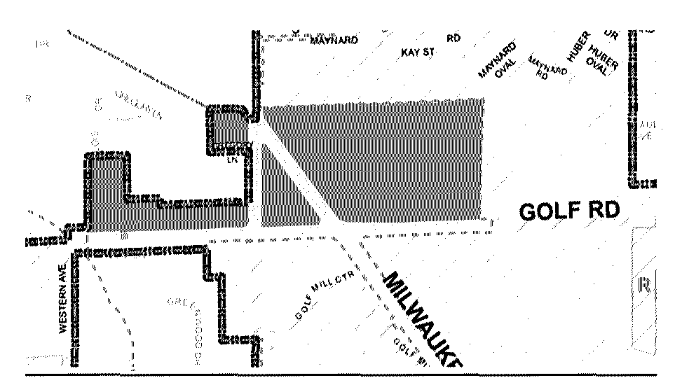
The C-E Overlay District is comprised of two areas and are described as follows:
Northern area:
The parcels fronting the north property lines of Golf Road between Western Avenue
and Greenwood Avenue, the parcel to the west of Greenwood Avenue north of Gregory
Lane and south of Milwaukee Avenue, and the parcels that are bounded by Greenwood
Avenue to the west, Golf Road to the south and the Commonwealth Edison Company R.O.W.
to the north and east.
Southern area:
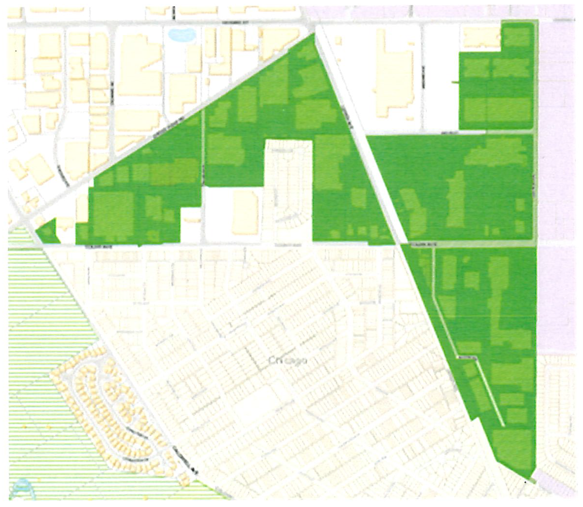
The following is a general description of the properties located within the Southern
Cannabis Establishment Overlay District, as identified on the map below:
• The parcels fronting the west side of Central Avenue between Howard Street and Jarvis Street;
• The parcels bounded by Jarvis Street to the north, Central Avenue to the east, Touhy Avenue to the south and Railroad to the west;
• All parcels south of Touhy Avenue, between Lehigh Avenue and Central Avenue;
• The parcels bounded by Lehigh Avenue to the east, Touhy Avenue to the south, Gross Point Road to the north and Melvina Avenue to the west, with the exception of the parcel commonly known as 6150 W. Touhy Avenue; and
• The parcels bounded by Melvina Avenue to the east, Touhy Avenue to the south. Gross Point Road to the north and Caldwell Avenue to the west, with the exception of the parcels commonly known as 7220 N. Melvina Avenue, 7225 N. Caldwell Avenue, 6480 W. Touhy Avenue, 6450 W. Touhy Avenue, and 6401 W. Gross Point Road.
B.
Uses
Section 8 lists permitted and special principal uses and temporary uses for the C-E Overlay District. All uses allowed within the underlying zoning district or districts are also allowed in the C-E Overlay District.
C.
Dimensional Standards
The dimensional standards within the C-E Overlay District shall be those development standards in effect in the underlying zoning district or districts.
D.
General Standards of Applicability
1.
Site Development Standards
The development standards within the C-E Overlay District shall be those development standards in effect in the underlying zoning district or districts. See Section 9 for additional on-site development standards and requirements, such as exterior lighting, accessory structures and uses, and permitted encroachments.
2.
Off-Street Parking and Loading
See Section 10 for off-street parking and loading standards and requirements.
3.
Landscape
See Section 11 for landscape, buffering and screening standards and requirements.
4.
Signs
See Chapter 78 of the Niles Code of Ordinances for sign standards.
(Ord. No. 2019-32, § 2, 10-8-19; Ord. No. 2022-40, § 2, 6-28-22; Ord. No. 2024-36, § 2, 6-25-24)