
Omaha City Zoning Code
ARTICLE X
- SPECIAL DISTRICTS
Sec. 55-541.- AV, RR, MU, TOD.
(Ord. No. 42653, § 4, 8-31-21)
Sec. 55-542. - General purpose.
The special districts are included in this chapter to achieve the following objectives:
(a)
To provide sites for uses which are distinct in physical and operating characteristics from those allowed in basic residential, office, commercial or industrial districts.
(b)
To encourage innovative design of pedestrian oriented intersection mixed use projects in a manner consistent with the urban design elements of the city's comprehensive plan.
(c)
To provide locations for major public facilities.
(d)
To integrate special projects into the surrounding urban environment.
(Code 1980, § 55-542; Ord. No. 37810, § 24, 8-14-07; Ord. No. 42341, § 7, 10-27-20)
Sec. 55-544. - Purpose.
The AV aviation district is designed to accommodate major public and private airport facilities in the city.
(Code 1980, § 55-544; Ord. No. 42341, § 7, 10-27-20)
Sec. 55-545. - Permitted uses.
The following use types are permitted:
(a)
Aviation facilities.
(b)
Commercial facilities which are accessory to the operation of the airport and provide direct services to its users. Such uses may include but are not limited to financial services, personal services, general retail services, restaurants, cocktail lounges and service stations.
(c)
Agricultural and open space uses within clear zones, approach areas or areas reserved for future airport development.
(Code 1980, § 55-545; Ord. No. 42341, § 7, 10-27-20)
Sec. 55-546. - Site development regulations.
Use of each site for aviation facilities shall be subject to a special use permit approved by the city council, as provided by section 55-884.
(Code 1980, § 55-546; Ord. No. 42341, § 7, 10-27-20)
Sec. 55-548. - Purpose.
The RR railroad district is designated to accommodate active railroad right-of-way and directly railroad associated property, including land owned by the railroad as right-of-way, switching yards, maintenance facilities, or leased property adjacent to the right-of-way.
(Ord. No. 33064, § 2, 9-21-93; Ord. No. 42341, § 7, 10-27-20)
Sec. 55-549. - Definitions.
The following definitions shall be used for terms contained in sections 55-548 through 55-554 that are not otherwise defined in this chapter:
(a)
Abandonment: Discontinuation of railroad right-of-way as approved by the Interstate Commerce Commission (ICC) and/or the permanent removal of all trackage from that right-of-way.
(b)
Centerline: The greater of a point equidistant between parallel right-of-way lines or to the center of the active railroad trackage within the right-of-way.
(c)
Railroad associated land: Property owned by the railroad and adjacent to active railroad right-of-way used by private lease holders.
(d)
Railroad right-of-way: That land dedicated or acquired for the purpose of operating as a railroad transportation facility, including contiguous trackage, switching yards, maintenance facilities, and undivided land leased for uses requiring railroad access.
(Ord. No. 33064, § 3, 9-21-93; Ord. No. 42341, § 7, 10-27-20)
Sec. 55-550. - Permitted uses.
The following use types are permitted:
Transportation uses:
Railroad facilities.
Transportation terminal.
(Ord. No. 33064, § 4, 9-21-93; Ord. No. 42341, § 7, 10-27-20)
Sec. 55-551. - Use regulations.
All other uses shall be allowed only if they are also allowed on the adjacent property.
(Ord. No. 33064, § 5, 9-21-93; Ord. No. 42341, § 7, 10-27-20)
Sec. 55-552. - Site development regulations.
Improvements on railroad associated land shall conform to the site development regulations of the adjacent property.
(Ord. No. 33064, § 6, 9-21-93; Ord. No. 42341, § 7, 10-27-20)
Sec. 55-553. - Other regulations.
The regulations for landscaping (article XIII), off-street parking and loading (article XIV), supplemental use (article XV), supplemental site development (article XVI), performance standards (article XVII), and sign and street graphics (article XVIII) shall be the same as the regulations on the adjacent property.
(Ord. No. 33064, § 7, 9-21-93; Ord. No. 42341, § 7, 10-27-20)
Sec. 55-554. - Determination of adjacent property.
The regulations applicable to the adjacent property shall be determined by extending the intersecting zoning boundary perpendicular to the centerline of the railroad right-of-way. When the railroad right-of-way is adjacent to interstate highway right-of-way, the adjacent zoning classification shall be extended to the centerline of the interstate right-of-way.
(Ord. No. 33064, § 8, 9-21-93; Ord. No. 42341, § 7, 10-27-20)
Sec. 55-562. - Purpose.
The MU mixed use district is intended to accommodate projects that combine several compatible land uses into an integrated development consistent with the goals and policies of the land use and urban design elements of the city's comprehensive plan. It is the policy of the city to adopt the MU district in connection with rezoning of areas for projects that include commercial uses. The MU district allows for mixing residential environments with workplaces, shops and services in a manner that encourages these residential, commercial, office and accessory uses to occur in pedestrian-oriented mixed use centers of varying build-out sizes at those intersections designated for mixed use areas rather than in continuous strips along arterial streets. Development in the MU district must also accommodate transportation systems, surrounding environments and pedestrian movement. Projects constructed in an MU district are subject to approval through the special use permit procedure in section 55-884 based on the urban design review criteria set forth in article XXII (urban design), section 55-938.
(Code 1980, § 55-562; Ord. No. 37810, § 1, 8-14-07; Ord. No. 42341, § 7, 10-27-20)
Sec. 55-563. - Permitted uses.
The following use types are permitted in a project receiving approval by the city council pursuant to the special use permit procedure in section 55-884:
(a)
Residential uses.
Multiple-family residential
Townhouse residential
Assisted living
Small group living (disabled)
Small group living (nondisabled)
(b)
Civic uses.
Administrative services
College and university facilities
Community recreation
Cultural services
Day care (limited)
Day care (general)
Emergency residential care
Guidance services
Hospital services (limited)
Hospital services (general)
Local utility services
Park and recreation services
Postal facilities
Primary educational facilities
Recreational clubs
Religious assembly
Secondary educational facilities
Social clubs
(c)
Office uses.
Financial services
General offices
Medical offices
(d)
Commercial uses.
Automotive washing
Building maintenance services
Business support services
Business or trade school
Cocktail lounge
Communications services
Consumer convenience services
Consumer repair services
Food sales (limited)
Food sales (general)
Food sales (convenience)
Funeral services
General retail sales
Hotel/motel
Indoor entertainment
Liquor sales
Pawnshop services
Personal improvement services
Personal services
Pet services
Restaurant (drive-in)
Restaurant (limited)
Restaurant (general)
Service station
Veterinary services
(e)
Agricultural uses.
Commercial farm
Community garden
(f)
Uses subject to certain restrictions. Any of the following uses may be allowed when:
(1)
The location of the use is specifically designated on a site plan and includes detailed design plans, as required for a special use permit pursuant to section 55-884, and is submitted for each designated site as a part of the development plan.
(2)
The location is designated and approved through the special use permit procedure or with a major amendment to the development plan pursuant to subsection 55-565(d).
a.
Residential uses.
Large group living
b.
Civic uses.
Transitional living
Public assembly
Safety services
c.
Commercial uses.
Agricultural sales and service
Automotive rentals
Auto repair services
Automotive sales
Convenience storage
Construction sales and service
Exterminating services
Indoor sports and recreation
Laundry services
Outdoor sports and recreation
Research services
Surplus sales
d.
Parking.
Parking structure
Surface parking
e.
Industrial uses.
Custom manufacturing
Light industrial
Warehousing and distribution (limited)
f.
Transportation uses.
Transportation terminal
g.
Miscellaneous uses.
Broadcasting tower
Wind energy conservation system
(Code 1980, § 55-563; Ord. No. 35576, § 1, 5-8-01; Ord. No. 37810, § 1, 8-14-07; Ord. No. 38198, § 28, 7-29-08; Ord. No. 39371, § 5, 6-26-12; Ord. No. 42341, § 7, 10-27-20; Ord. No. 43400, § 1, 5-2-23)
Sec. 55-564. - Site development standards and guidelines.
All projects in an MU district are subject to the following site development standards and guidelines.
(a)
Urban design standards. Each project located on a site or lot in an MU district shall comply with the urban design standards set forth at the following sections:
(1)
Sidewalk areas. Article XXII (urban design), section 55-924.
(2)
Build-to/set-back lines and zones. Article XXII (urban design), section 55-925.
(3)
Ground-level transparency. Article XXII (urban design), section 55-926.
(4)
Screening of service areas. Article XXII (urban design), section 55-927.
(5)
Green parking areas. Article XXII (urban design), section 55-928.
(6)
Parking structures. Article XXII (urban design), section 55-929.
(7)
Site and building access. Article XXII (urban design), section 55-930(a) and (b).
(8)
Neighborhood connectivity. Article XXII (urban design), section 55-931.
(9)
Location of utilities. Article XXII (urban design), section 55-932.
(10)
Signs. Article XXII (urban design), section 55-933.
(11)
Retaining walls; landscape berms. Article XXII (urban design), section 55-934.
(b)
Building design guidelines. All projects in an MU district are subject to the following building design guidelines:
(1)
Building design guidelines. Article XXII (urban design), section 55-935.
(c)
Mixing of uses. All projects in an MU district shall include a mix of uses in accordance with the following provisions:
(1)
Office. At least ten percent of the aggregate area of any MU district shall be used for office uses. "Office" shall mean a building designed and constructed to provide for office occupancy only. Such buildings shall be characterized by a single primary entrance, a central lobby serving as access to tenant suites, and when appropriate, multiple stories or include other design characteristics that differentiates it from typical in-line retail or other non-office use buildings. Commercial uses shall be allowed as incidental uses within the area set aside for office uses only if located within multi-story buildings.
Alternative compliance.
a.
This requirement can be met by agreement between individual mixed-use districts at an intersection. Existing office developments at an intersection in excess of the ten percent requirement can be credited to adjacent mixed-use developments at the intersection to help meet the ten percent minimum requirement, provided the total minimum percentage of land devoted to office use is at least ten percent of the area of the combined developments.
b.
In the event that the project provides for at least one multi-story, multi-use building, a lower percentage of office uses will be allowed. In such cases, the multi-story, multi-use building must contain a total square footage equal to one-eighth of the otherwise required ten percent office site area.
c.
The required office use may be exchanged for approved residential uses by a factor of no less than two. For example, one acre of office use shall equal no less than two acres of residential use. Any residential use provided under this section shall contribute toward the pedestrian open space requirement of subsection 55-564(e) and comply with the build-to/set-back requirements for an internal main street.
(2)
Fast food. No more than 12 percent of the aggregate area of any MU district may be used for free-standing fast food restaurants.
Alternative compliance.
a.
This requirement can be met by agreement between individual mixed-use districts at an intersection. Existing developments with less than 12 percent of their land devoted to free-standing fast food restaurants can be aggregated with adjacent mixed-use developments at an intersection to allow for additional free-standing fast food restaurants in the adjacent developments, provided the total percentage of land devoted to this use does not exceed 12 percent of the area of the combined developments. In no event shall the land devoted to free-standing fast food restaurants at any one corner exceed 18 percent.
(3)
Convenience storage. No more than ten percent of the aggregate area of any MU district may be used for a convenience storage use pursuant to the requirements of section 55-561 concerning mixed use districts and subsection 55-765(e) concerning supplemental use regulations for convenience storage.
(4)
Residential uses. Lots with approved residential uses shall have direct access to a public or private street system with a maximum block length of 600 feet and developed to standards for an internal main street within MU districts. Private streets shall be designed to city standards and may be located in an outlot.
(d)
Circulation systems. In addition to the sidewalk area requirements of article XXII (Urban Design), section 55-924, all projects in an MU district shall comply with the following standards related to pedestrian systems:
(1)
Projects shall be designed for pedestrians as well as automobiles and include a system of streets consisting of internal main streets, internal streets or access drives pursuant to section 55-32.
(2)
Projects shall include a system of sidewalks and pedestrian pathways providing for clear and direct connections between the entrances of all buildings and adjacent developments, including, without limitation, residential developments.
(3)
Buildings located on lots adjacent to perimeter streets must have access to both the perimeter and internal sidewalk system.
(4)
Internal main street and internal street intersections shall be designed to facilitate pedestrian movement. Corner nodes or similar devices shall be used to define on-street parking areas and to limit the width of pedestrian crossings to be the same as the width of the traveled lanes. Pedestrian crossings shall be distinguished from other driving surfaces through the use of paving materials such as brick or colored concrete pavers or equivalent.
(5)
Uses which include drive through operations shall be designed in such a way as not to inhibit, block or restrict the pedestrian network within the development and primary pedestrian access to any building. Specifically, stacking space for vehicles must be sufficient so that vehicles waiting in line will not block sidewalks. Driveway crossings of areas designated as pedestrian plazas will also not be allowed.
(6)
Lots abutting an internal street shall be limited to one unshared access from any internal street system.
(7)
Internal main streets and internal streets shall not exceed 25 feet in width, except where additional width is provided to accommodate on-street parking or where the internal main street or internal street connects to an arterial street, or where turning movements are needed and are approved by the public works department.
(8)
Traffic calming techniques such as on-street parking, corner nodes and bollards shall be utilized, where appropriate.
(9)
Projects located adjacent to parks and trails shall make pedestrian connections to such parks and trails.
(10)
Off-street bicycle parking shall be provided in accordance with section 55-745.
(11)
Documentation shall be obtained from Metro Area Transit indicating whether a bus service is required for the project and, if so, how that bus service will be accommodated.
(12)
Exceptions to pedestrian system standards: In cases where sites present exceptionally difficult terrain, site configuration or similar problems, alternative pedestrian systems will be considered provided such systems meet the intent of the circulation system standards outlined in this section (subsection 55-564(d)).
(e)
Pedestrian oriented open spaces. Each MU district shall include a minimum amount of usable outdoor open space that is designed primarily as an enhancement of the pedestrian environment. Such usable outdoor open space(s) shall equal no less than three percent of the total lot area for each district and shall not include open space otherwise required by the zoning code such as landscaping or sidewalks. Such spaces shall be made available for public use and may be located in the public right-of-way, private property or an outlot and shall be described in a detailed exhibit that identifies all design elements, landscaping and contributing area. This requirement may be satisfied by one or a combination of the following design features.
(1)
A pedestrian oriented streetscape serving any allowed use and conforming to the build-to/set-back requirements for an internal Main Street within MU districts.
(2)
Dedicated pedestrian pathways in addition to required sidewalks pursuant to section 55-924. Such pathways shall be a minimum of seven feet wide and may connect adjacent residential neighborhoods to the district, provide pedestrian connectivity through parking lots or provide trails through natural areas or other similar non-vehicular pathways. Pedestrian pathways shall have at least six feet of open space/maintained landscaping on either side of the pathway.
(3)
Enhancements to street sidewalk areas that exceed the minimum dimensions of section 55-924 and include pedestrian scaled street lights per the city's urban design standards.
(4)
Enhancements to building sidewalk area that exceeds the minimum dimensions of subsection 55-935(d)(8). Such area shall be no less than 25 feet wide and designed as a pedestrian oriented space as defined in subsection 55-925(a)(1)a.
(5)
Enhancements to transit stop areas exceeding the minimum standard practice.
(6)
Other design features considered part of the pedestrian network and approved through the special use permit process.
(7)
A public plaza. Such area shall for pedestrian use only, be framed on three sides including no less than two building elevations, designed as a pedestrian oriented space as defined in subsection 55-925(a)(1)a. and is connected to pedestrian network of the district and surrounding area.
(8)
A town square.
(9)
A park-like area.
(10)
A playground or similar recreational feature.
(11)
A performance stage/amphitheater.
(12)
Access to natural environment areas, lakes, streams or similar natural areas.
(13)
Storm water detention basins designed as park-like areas with pedestrian amenities and access.
(14)
Other design features considered a pedestrian place and approved through the special use permit process.
(f)
Baseline location(s). The baseline for determining building location along internal main streets or internal streets shall be the property line but shall not be less than the minimum distance to accommodate sidewalks pursuant to section 55-924.
(1)
Adjustments to the baseline. The baseline location and/or its geometry may be adjusted to accommodate one or more of the following conditions, provided that at minimum it shall be located so as to provide for the sidewalk requirements in section 55-924 and shall be approved by the planning director:
a.
To accommodate irregular, non-parallel or unusual street alignment.
b.
To accommodate irregular or unusual property lines.
c.
To accommodate irregular or unusual building placement.
d.
To provide for future street improvements.
e.
To provide for acceleration, deceleration or turn lanes.
f.
To provide for on-street parking.
g.
To provide for a dedicated and permanent public amenity such as public art or a plaza.
(g)
Green corners. All projects in an MU district located at the intersection of arterial streets shall provide a landscaped area at the intersection which shall extend approximately equal distances along each arterial street. The landscaped area shall be framed by adjacent buildings, structures or landscaping.
(1)
Minimum area. The amount of landscaped area required at each corner shall be 5,000 square feet/quadrant, with a maximum dimension along each street of 80 feet measured along the property line.
(2)
Clear area. A minimum of 40 percent of each green corner shall be included within a "clear area" where plant materials must be less than 30 inches in height. The 40 percent clear area shall include a "sight triangle" that extends a minimum dimension along each arterial street of 35 feet measured along the property line.
(3)
Permitted sign locations and types. One business center sign in addition to those described in subsection 55-933(c) shall be permitted to be located adjacent to green corners only as shown on Figure 55-564(1), and shall not be permitted within the area of the green corner. Business center signs adjacent to green corners shall be monument signs no more than six feet in height as measured from average grade to the highest point of the sign structure, including any structural elements of the sign such as pillars or posts and shall contain no tenant advertising. All signs shall be constructed of masonry materials and have a masonry base. Internally illuminated signs are not allowed. This additional business center sign will not be allowed when a business center sign described in subsection 55-933(c) is located within 50 feet of the green corner.
(4)
Building setbacks. There shall be no required minimum building setback from a green corner.
(5)
Landscaping. Green corners shall be landscaped using a combination of over story and under story trees, shrubs and annual and perennial flowers to frame the green corner and define the edges of the green corner that are opposite the streets. Landscaping shall be arranged to preserve the 40 percent clear area required by subsection 55-564(f)(2), above. The minimum number of over story and under story trees shall be one tree for every 1,000 square feet of green corner.
(6)
Grade separated intersections. Alternative designs that meet the size requirement and intent of the green corner regulations will be considered on a case by case basis for projects in MU districts that abut grade separated intersections. Developments that abut grade separated intersections will be allowed to arrange for the placement of an equivalent amount of landscaping at the public right-of-way provided the developer of the project reaches an agreement with the Nebraska Department of Roads and obtains the approval of the public works department.
(7)
Notwithstanding anything contained in subsection (f)(1) through (6), an off-premises sign which is both existing and legally conforming immediately prior to the effective date of adoption of an MU district for the property on which such sign is located (provided, that the MU district is first made applicable to that property on some date after the effective date of this subsection (f)), shall continue to be deemed legally conforming, so long as it continues to comply with all other applicable provisions of this Code.
See Figure 55-564(2), Green Corner.
(h)
Stormwater detention areas. Areas in any project in an MU district required for stormwater detention shall be designed as visually appealing open space.
(1)
Stormwater detention areas that are steep-walled, pit-like and require fencing for safety shall be screened from view with landscaping, berms, solid fencing or some combination of these features so that the detention area is not casually visible from adjacent plazas, open space, roadways or parking lots as shall any detention area steep enough to require a fence around the majority of the basin.
(2)
Stormwater detention areas with engineered slopes greater than 3:1 shall be heavily landscaped.
(3)
This section does not prohibit use of underground detention areas.
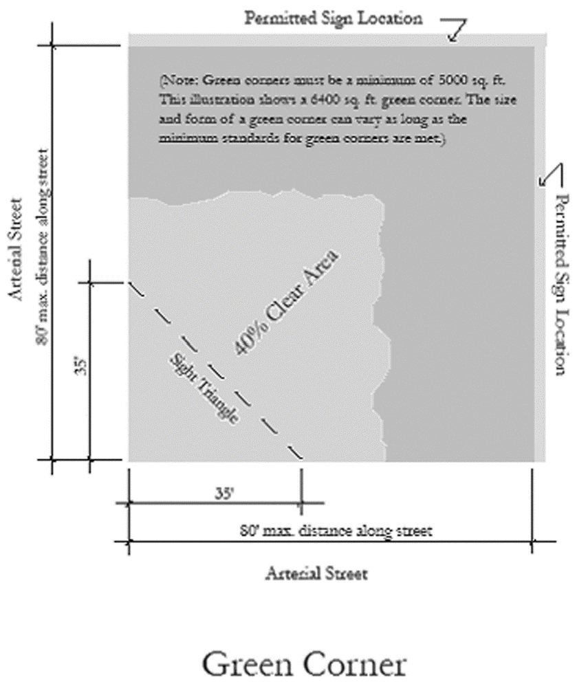
Figure 55-564(1)
(Code 1980, § 55-564; Ord. No. 37810, § 1, 8-14-07; Ord. No. 38907, § 1, 12-21-10; Ord. No. 39358, § 1, 6-19-12; Ord. No. 42341, § 7, 10-27-20)
Sec. 55-565. - Minimum area; application for approval; modifications.
(a)
Minimum area. The minimum area of any MU district is three acres.
(b)
Special use permit. All MU districts shall be subject to approval by the city council, through the special use permit procedure set forth in section 55-884 using the criteria set forth at article XXII (urban design), section 55-938. Such approval may be granted for a comprehensive development plan that is in conformance with applicable zoning provisions. All subsequent structures or developments shall be consistent with such development plan and the applicable zoning provisions.
(c)
Applications. Applications for approval shall include at least the following information:
(1)
A detailed plat map or survey, including:
a.
Lot identification number.
b.
Lot area (acres).
c.
Property lines and dimensions.
d.
Public rights-of-way, both adjacent and interior.
e.
Easements.
f.
Survey certificate.
g.
Description of other site features, including drainage, soils or other considerations that may affect the development of the site.
(2)
A development plan should include, as a minimum;
a.
Property lines.
b.
Buildings footprints.
c.
Paved surfaces.
d.
Street types and sections.
e.
Landscaping and green corners.
f.
Pedestrian network and connectivity plan.
h.
Pedestrian oriented place design details.
i.
Storm water facilities.
j.
Business identification and or monument signs.
k.
Site statistics table containing the following information for each lot including summation of values as necessary:
1.
Lot identification.
2.
Site area (acres).
3.
Building use type.
4.
Building footprint (sq. ft.).
5.
Building height/number of floors.
6.
Total building floor area.
7.
Reserved.
8.
Number of parking stalls.
(3)
Detailed site plans as necessary.
(4)
Grading plans.
(5)
Building design/elevations.
(6)
A sign plan and sign budget table describing the site signage design and allocation of sign budget for each site.
(7)
A traffic impact analysis, if required by the public works director, completed according to standards and requirements on file with the city clerk.
(d)
Amendment to development plan. The planning director is authorized to approve an amendment to an approved development plan, provided that:
(1)
A written request for amendment is filed with the planning director, along with information describing the exact nature of the proposed amendment.
(2)
The amendment is compliant with the provisions of this section.
(3)
The amendment does not substantially alter aspects of the development plan, including traffic circulation, mixture of use types and physical design.
(4)
Any proposed amendment not conforming to the provisions of this subsections 55-565(d)(2) through (3) above must be resubmitted to the planning board and the city council following the special use permit procedure. Either the applicant or the planning director may request the urban design review board to review and provide a recommendation on the issue of whether it requires resubmittal to the planning board and city council. After taking such recommendation into consideration, the planning director shall determine whether the proposed amendment must be resubmitted to the planning board and city council.
(e)
Building, development permits. The permits and inspections division shall issue building or development permits consistent with the provisions of the approved development plan and any amendments thereof.
(Ord. No. 37810, § 1, 8-14-07; Ord. No. 42341, § 7, 10-27-20)
Sec. 55-570. - TOD transit oriented development district—General.
(a)
Purpose. The purpose of the TOD, transit oriented development district, is to implement the city's master plan by facilitating infill development and redevelopment in those parts of the city which, because of their proximity to pedestrian oriented mass transit infrastructure, are considered of primary importance to create active, pedestrian oriented streetscapes and developments that vary in intensity and use which shall be referred to as "TOD" districts.
(b)
TOD general characteristics.
(1)
Building heights vary depending on context and proximity to transit stations;
(2)
Building entrances relate directly to the street and sidewalk with a strong uniform building line;
(3)
Buildings include a high degree of transparency;
(4)
Buildings provide a mixture of commercial, office and residential uses depending on context and proximity to transit stations;
(5)
Provide parallel or diagonal on-street parking or the potential for on-street parking on all streets;
(6)
Provide wide curbside landscaping and sidewalks;
(7)
Provide pedestrian-oriented streetscapes and street lighting;
(8)
No off-street parking between the building and the street;
(9)
Width of pavement of the adjacent streets is relatively narrow; a pedestrian can cross without much difficulty; buildings relate to one another across the street.
(c)
Zoning district nomenclature. TOD districts will vary in terms of the development size and scale pursuant to section 55-574 and allowable uses pursuant to section 55-573. The zoning nomenclature will combine size/scale districts (TOD-1, 2, 3 and 4) and include a use type modifier (MX, MUR, MNR or SFA) to produce unique zoning districts. For example, a parcel zoned TOD-2-MUR would follow the TOD-2 site development regulations pursuant to section 55-574 and the uses allowed pursuant to section 55-573.
(d)
Definitions.
(1)
Baseline location. For the purposes of determining build-to/set-back requirements pursuant to section 55-925, baseline locations for TOD districts shall coincide with the property line.
(2)
Building height. Building height shall be measured as the vertical distance from the average grade of each elevation adjacent to the building to the highest structural element of the uppermost building story, excluding non-structural elements such as parapets and eaves. Occupied space within roof framing utilizing a pitch of less than or equal to 1:1, including dormers, which are less than 40 percent of the adjacent facade length, are excluded from the height calculation. Additional height exceptions are allowed pursuant to section 55-783.
(3)
Dominant pattern. A dominant pattern shall be defined as a consistent physical characteristic demonstrated by contiguous lots equal to not less than 70 percent of a block-face.
(Ord. No. 42341, § 7, 10-27-20)
Sec. 55-571. - Applicability.
(a)
TOD district boundaries. The provisions of sections 55-570 through 55-578 shall apply to any project on a lot or site in a TOD district.
(b)
Conflict of provisions. Where the provisions of sections 55-570 through 55-578 conflict with the provisions of any other sections of the zoning code, the provisions of sections 55-570 through 55-578 shall control.
(c)
Cross reference to other applicable provisions. Each TOD district shall comply with the applicable sections of the zoning code using the equivalencies prescribed in the Table 1—Equivalent Cross Reference Zoning. All other sections of the zoning code apply to TOD districts, specifically, but not limited to the following:
(1)
Article 16—Supplemental Site Development Regulations.
(2)
Article 17—Performance Standards.
(3)
Article 18—Street and Sign Graphics Regulations.
(4)
Article 19—Non-Conforming Development.
Table 1—Equivalent Cross Reference Zoning
(Ord. No. 42341, § 7, 10-27-20)
Sec. 55-572. - Street design standards.
(a)
Street design. Street design for TOD districts shall conform to the city street design manual.
(b)
Block length. Development sites in TOD districts greater than five acres shall include intervening public or private street(s) connecting to the adjacent existing street system achieving block faces that do not exceed 350 feet.
(c)
Sidewalks. Refer to section 55-924 for sidewalk requirements.
(d)
Street lighting. Pedestrian oriented street lighting shall be provided for all new development or redevelopment in TOD districts in accordance with city standards for urban design districts.
(e)
Alternative lot access. Alternative lot access may be provided as approved by the director of public works in accordance with alternative city standards.
(Ord. No. 42341, § 7, 10-27-20)
Sec. 55-573. - Uses.
(a)
TOD districts shall include a mixture of compatible use types divided into two general groups; those including a mixture of compatible commercial, office, civic and residential (MX) and those including a mixture of compatible residential uses (MUR, MNR and SFA). TOD district zoning classification shall include one of the following use categories:
Table 1 - Allowed Uses
(Ord. No. 42341, § 7, 10-27-20; Ord. No. 43400, § 1, 5-2-23; Ord. No. 43728, § 1, 3-5-24)
Sec. 55-574. - Site development regulations.
Table 1—Site Development Parameters (4)
Notes:
1. Minimum lot area may be reduced if part of an attached housing development provided that the maximum building footprint for the common structure is not exceeded.
2. The front yard build-to/setbacks for residential use only buildings shall be the greater of either a) section 55-925 or, b) the average setback demonstrated by the dominant pattern of the existing context pursuant to subsection 55-570(d)(3).
3. Rear yard setbacks may be reduced by 70 percent when located on an alley.
4. Subsection 55-576(g) for additional setback requirements.
Table 2—Building Size Parameters
Key: UL = Unlimited NR = Not Required
Notes:
1. The minimum height for TOD-1 districts shall be the four stories.
2. The minimum height for TOD-2 districts shall be two stories.
3. Maximum footprint restriction only applies to MUR, MNR and SFA use categories.
4. Refer to subsection 55-576(a) for maximum facade heights applied to the base of buildings.
(Ord. No. 42341, § 7, 10-27-20)
Sec. 55-575. - Urban design standards.
Development within TOD districts shall comply with the urban design standards set forth in the following sections unless modified by sections 55-570 through 55-578:
(a)
Sidewalk areas. Article XXII (urban design), section 55-924.
(b)
Build-to/set-back lines. Article XXII (urban design), section 55-925.
(c)
Ground-level transparency. Article XXII (urban design), section 55-926.
(d)
Screening of service areas. Article XXII (urban design), section 55-927.
(e)
Green parking areas. Article XXII (urban design), section 55-928.
(f)
Parking structures. Article XXII (urban design), section 55-929.
(g)
Site and building access. Article XXII (urban design), section 55-930.
(h)
Neighborhood connectivity. Article XXII (urban design), section 55-931.
(i)
Location of utilities. Article XXII (urban design), section 55-932.
(j)
Signs. Article XXII (urban design), section 55-933.
(k)
Retaining walls; landscape berms. Article XXII (urban design), section 55-934.
(l)
Building design guidelines. Article XXII (urban design), section 55-935.
(Ord. No. 42341, § 7, 10-27-20)
Sec. 55-576. - Supplemental standards.
(a)
Maximum height for base of buildings. Principal exterior building facades greater than the maximum base height set forth in section 55-574, Table 2, shall step back a minimum of ten feet for at least 70 percent of each street facing facade.
(b)
Building frontage. Buildings or approved structures shall occupy a minimum of 70 percent of the buildable street frontage for at least one street facing facade pursuant to section 55-925, build-to/set-backs. Sites with multiple street frontages shall meet this requirement along the principal transit corridor, if adjacent, or the longest street facing facade.
(c)
Vehicular parking and access.
(1)
On-street parking. Parking shall be provided on all public streets to the extent feasible and as approved by both the director of public works and the director of the planning department. On-street parking adjacent to a property may be counted towards the minimum parking requirement.
(2)
Minimum parking. The minimum number of required parking spaces for TOD-2, TOD-3, TOD-4 districts shall be 50 percent of the required parking spaces pursuant to section 55-734. TOD-1 districts shall have no minimum parking requirement. The minimum parking requirements of this section shall not exceed the requirement of existing zoning prior to adoption of this code and or the rezoning to a TOD district.
(3)
Maximum parking area. On-site surface parking lots and drive lanes for TOD districts shall not exceed 35 percent of the total buildable lot area.
(4)
Vehicle circulation and location. Vehicle areas such as parking lots, drive lanes and other vehicle oriented site features and circulation shall not be located between a street facing facade and the street, as set forth in section 55-925, or closer to an adjacent street than the adjacent building facade.
(5)
Alleys. When a serviceable alley is available to a lot zoned for MUR, MNR or SFA residential uses and that lot contains two or more units, access shall be provided from the alley. A serviceable alley is one that has current and active use and a right-of-way width 16 feet or greater.
(6)
Garage doors. Garage doors shall be designed to minimize their exposure along public streets and sidewalks.
a.
Street facing facades shall include no more than one, two-way garage door or two, one-way garage doors. In no case shall the garage door width exceed 50 percent of the street facing facade. Attached housing and zero lot line buildings shall be considered one street facing facade.
b.
Garage doors shall not extend closer to the street than the longest street facing wall.
(d)
Bicycle parking. Off-street bicycle parking shall be provided in accordance with section 55-745.
(e)
On-site pedestrian circulation. An on-site pedestrian circulation system shall be provided and meet the following requirements:
(1)
The pedestrian system shall connect all adjacent public rights-of-way to all main building entrance(s), to all buildings on-site and other areas of the site likely to be used by pedestrians, such as parking areas, bicycle parking, recreational areas, common outdoor areas, and pedestrian amenity features. The connection shall follow a direct route and not involve significant out-of-direction travel for system users.
(2)
The pedestrian system must be paved and be at least five feet in width.
(3)
Where the sidewalk or on-site pedestrian circulation system crosses driveways, parking areas or loading areas, it must be clearly differentiated to avoid conflict between pedestrians and traffic through the use of consistent sidewalk grade across driveways or raised pedestrian crossings. Painted demarcation does not meet this requirement.
(f)
Building design, supplemental requirements—General.
(1)
Transparency. The minimum transparent area pursuant to section 55-926 shall be increased to no less than 50 percent. The minimum transparency for street facing facades above the first floor shall be no less than 30 percent.
(2)
Signs. Building signs shall not be placed higher 30 feet above finished grade.
(g)
Building design, supplemental requirements—Residential use only buildings.
(1)
Ground floor entrances. The following provision(s) apply to ground floor residential unit entrances that are located 20 feet or less from a baseline, public right-of-way, sidewalk or adjoining property line.
a.
The residential unit entrances shall be designed to include a public-private transitional element such as a porch, elevated stoop, enclosed patio, forecourt or other approved design treatment. Such features shall be no less than seven feet in any dimension, no less than 50 square feet in total area and shall be defined by permanent vertical architectural elements such as walls, railing, roof, fences, columns, trellis or similar features.
b.
Facades containing residential entrances facing an interior side lot line shall be set a minimum of 15 feet back from the adjoining property.
(2)
Exterior stairs. Exterior stairs providing access to residential units shall not exceed 60 inches in total height above grade. Stairs exceeding this dimension shall be located internal to the building or be integrated into the architectural design and, or grade of the site.
(3)
Ground floor elevation. The following provision(s) apply to ground floor residential units that are located 15 feet or less from a baseline, public right-of-way, sidewalk or adjoining property line. Ground floor residential units shall be elevated an average height of 36 inches and no less than 18 inches above adjacent grade unless provided with a street facing entrance pursuant to subsection 55-576(g)(1).
(4)
Projecting balconies. Balconies shall be fully or partially integrated into the building facade and shall extend no further than 24 inches from the adjacent street facing facade.
(5)
Roof forms. Residential only buildings located in TOD-3 and TOD-4 districts shall include roof forms that are similar to the dominant pattern of the existing context. See subsection 55-570(d) for definition of a dominant pattern.
(h)
Screening and separation of uses. Screening and separation requirements shall apply to adjoining rear and side lot property lines for all TOD districts, pursuant to Table 4—Screening and Separation, when adjacent to an existing developed residential lot of two or fewer units. The following types of screening shall be used:
(1)
Type A: Fence/wall. Provide a six-foot minimum high opaque fence/wall.
(2)
Type B: Landscape screen. Provide a ten-foot minimum wide continuous landscaping strip providing a hedge-like screen or a random and informal screen of evergreen or approved deciduous plant material, capable of providing a substantially opaque barrier and attaining a minimum height of six feet within three years of planting. A landscape screen shall be planted initially at minimum spacing and size consistent with the City of Omaha's Standards for Urban Landscaping, which is on file with the planning director.
(3)
Type C: Vertical landscape screen. Vertical screening shall be provided by means of a ten-foot minimum wide continuous landscaping strip planted with two-inch minimum caliper trees reaching a minimum mature height of 25 feet and spaced no less than 15 feet apart.
Table 4—Screening and Separation
Notes:
1. Refer to section 55-927 for additional screening requirements.
(Ord. No. 42341, § 7, 10-27-20)
Sec. 55-578. - Administrative procedures.
(a)
Urban design site plan review. All projects within TOD districts shall require urban design site plan approval pursuant to article XXII (urban design), section 55-937.
(Ord. No. 42341, § 7, 10-27-20)