
Omaha City Zoning Code
ARTICLE XXI
APPENDIX—SPECIAL PURPOSE OVERLAY DISTRICTS11
Cross reference— Overlay districts, § 55-581 et seq.
Sec. 55-901.- North Hills environmental resources overlay district created.
There is hereby created an environmental resources overlay district for an area known as the North Hills as hereinafter described. It is the purpose, in the creation of this environmental resources overlay district, and in the provisions of this article, to provide for a special overlay district in addition to all other zoning and similar land use regulations so that certain acts with potentially damaging environmental effects require a permit in order to be undertaken for the protection of such area.
It is hereby acknowledged that the North Hills area is characterized by steep slopes and valleys with heavy forestation and ridge tops of forests or uncultivated grasslands. It is further recognized that the loess-based soil in the area is erodible and that vegetation is necessary to hold such soil in place by reducing the speed and volume of storm water runoff.
The North Hills environmental resources overlay district (E.D. North Hills) shall comprise the area described as within the following boundaries: 78th Street, from the Washington County line south to Omaha Trace Road; Omaha Trace Road east to 72nd Street; 72nd Street south to State Street; State Street east to 60th Street; 60th Street south to King Street; King Street east to 54th Avenue; 54th Avenue southeast to Sheffield Street; Sheffield Street east to Mormon Bridge Road; Mormon Bridge Road north to Young Street; Young Street east to State Street; State Street east to North Ridge Drive; North Ridge Drive north and east to 30th Street; 30th Street north to McKinley Street; McKinley Street west and northwest to I-680; I-680 east to John J. Pershing Drive; John J. Pershing Drive north to the south boundary line of N.P. Dodge Park; south boundary line of N.P. Dodge Park east to Nebraska state line; Nebraska state line north to the Washington County line; and the Washington County line west to the point of beginning.
(a)
Acts requiring special use permit. It shall be unlawful for any person to commit any of the following described acts within the E.D. North Hills district without first obtaining a special use permit pursuant to section 55-884 of the Omaha Municipal Code, to wit:
(1)
Grading and excavating.
a.
The removal, addition or relocation in any 12-month period of soil or other fill materials from any single parcel owned or controlled by any single entity, including joint tenants or co-tenants, when one or more of the following conditions are met: (a) the disturbed area exceeds one-half acre in size on slopes of less than 17 percent, (b) the volume exceeds 200 cubic yards, (c) the duration of such activity exceeds 30 consecutive days.
b.
The removal, addition or relocation in any 12-month period of soil or other fill materials from any single parcel owned or controlled by any single entity, including joint tenants or co-tenants, when: (a) the disturbed area exceeds 5,000 square feet on slopes between 17 percent and 30 percent, (b) the disturbed area exceeds 1,000 square feet on slopes of 30 percent to 50 percent.
(2)
Removal of vegetation.
a.
The destruction or removal of more than one-half acre of tree canopy on slopes under 17 percent in any 12-month period on any single parcel of ground under the ownership or control of any single entity, including joint tenants or co-tenants;
b.
The destruction or removal of two acres or more of canopy of trees on slopes under 17 percent in any period of six or fewer consecutive years on any single parcel of ground owned or controlled by any single entity, including joint tenants or co-tenants;
c.
The removal or destruction of tree canopy and/or other vegetation upon steep slopes on any single parcel of ground owned or controlled by any single entity, including joint tenants or co-tenants, when: (a) the amount of vegetation to be removed or destroyed exceeds 5,000 square feet on slopes between 17 percent and 30 percent, (b) the amount of vegetation to be destroyed exceeds 1,000 square feet on slopes between 30 percent and 50 percent.
As used herein, the expression "canopy of trees" refers to the maximum perimeter of vegetation of any tree or groups of trees growing together as viewed from overhead.
(3)
Disturbance of sensitive or unique features. Any removal, addition or relocation of soil or other fill materials, or the removal or destruction of any vegetation on or within 50 feet of any land which contains one or more of the following: (a) native prairies, (b) intermittent and perennial streams, (c) loess bluffs and glacial till, (d) extremely steep slopes.
As used herein, the expressions listed above refer to the following:
a.
Native prairies: Unplowed land dominated by native grasses and herbaceous plants.
b.
Intermittent and perennial streams: Those streams shown on the USGS 7½-minute quadrangle maps. For this purpose the stream area includes all land and water between the tops of the stream banks.
c.
Loess bluffs and glacial till: Those features identified by the symbols "Rn" and "#" in the Soil Survey of Douglas and Sarpy Counties prepared by the Soil Conservation Service.
d.
Extremely steep slopes: Those slopes over 50 percent in grade.
(4)
Exceptions.
a.
Nothing herein will be construed as requiring a permit for the plowing or disking for agricultural production of any land which was used for the production of an annual crop or in any one or more of the five years preceding such act for the purpose of feeding animals.
b.
Nothing herein will be construed as requiring a special use permit for any work done by any political subdivision on any dedicated street or drainage right-of-way.
c.
Nothing herein shall be construed as requiring a special use permit for this activity when done solely for the purpose of and incidental to the construction of a single-family residence on an existing tract or lot.
(b)
Criteria and standards. In order to obtain approval for a special use permit, the applicant's proposal must be in accordance with the following criteria and standards and, for the purpose of this special use permit, the criteria set out in section 55-885 of the Omaha Municipal Code shall have no application. Control measures in addition to those listed below may be imposed as conditions of the permit as needed in order to reduce or prevent environmental damage to meet the standards listed in this section.
(1)
Grading and excavating.
a.
Erosion and sediment control. Proposed activities shall be carried out in a manner that minimizes erosion on the site, siltation of waterways, loss of sensitive soils, and deterioration or damage to manmade structures, wildlife habitat and protective vegetation.
An erosion and sediment control plan must be prepared in accordance with the principles, standards and specifications set out in the Omaha Metropolitan Area Soil Erosion and Sediment Control Manual.
b.
Excessive cut and fill. Plans for development and construction shall provide for the minimum cut and fill necessary to support a land use permitted by the applicable existing zoning district and/or the city's future land use plan.
c.
Dust control. Dust control measures set out in the Omaha Metropolitan Area Soil Erosion and Sediment Control Manual shall be followed.
d.
Surface drainage. Proposed activities should avoid alteration of existing drainage patterns and increases in the volume or velocity of stormwater runoff from the site that would exceed the capacity of existing drainageways or result in damage to the natural or manmade environment.
If the proposed activity exceeds the capacity of existing drainageways or results in environmental damage, a stormwater control plan must be developed. The plan must be in accordance with the principles, standards and specifications contained in the Omaha Metropolitan Area Stormwater Management Design Manual. Stabilization methods used must be compatible with the natural characteristics of the site.
Positive drainage shall be maintained on the site to prevent the accumulation of stormwater, except in designated locations.
e.
Screens and buffers. Noise, dust and visual effects of the proposed activity to surrounding uses must be reduced by incorporating buffer strips, screens and other applicable methods.
The following table shows the required minimum buffer distances (in feet):
*Screening requirements apply.
In areas where screening requirements apply, a six-foot opaque barrier shall be provided which visually screens the activity from adjacent uses as follows:
1.
A solid wood and/or masonry fence or wall at least six feet in height, of a design approved by the planning director.
2.
A hedge-like screen or a random or informal screen of evergreen or approved deciduous plant material, capable of providing a substantially opaque barrier and attaining a minimum height of six feet.
3.
A landscaped earth berm with a maximum slope of three to one, rising no less than six feet above the existing grade of the lot line separating the zoning districts.
4.
Any combination of these methods that achieves a cumulative six-foot-high screen.
5.
The screen shall be installed within the buffer so as to provide the most effective visual screen.
6.
Screening shall not adversely affect surface water drainage.
f.
Groundwater. The proposed activity shall not result in adverse effects on existing water supplies caused by reducing or impairing the function of the aquifer recharge area or by disturbance or pollution of the water table.
The permit holder shall not excavate below the water table or grade in a manner that exposes the water table or results in pollution of the water table.
Soil borings and an assessment of the effect of the proposed activity on the water table will be required if soils data in the Soil Survey of Douglas and Sarpy Counties indicates a potential effect to the water table. Modifications to the plan or other mitigation measures may be required to prevent potential adverse effects.
g.
Solid waste. Any solid waste material resulting from the proposed activity must be properly disposed of so that water quality and general health and safety are protected.
If solid waste, including vegetation and tree parts, is buried, city landfill regulations must be followed.
(2)
Removal of vegetation.
a.
Revegetation. Proposed activities should be designed and carried out in a manner which preserves as much natural vegetation and tree cover as possible. Whenever large areas of woodlands are destroyed, as much tree cover as possible should be restored.
At a minimum, 20 trees shall be planted for every one-half acre of tree canopy removed from the site. Tree species, sizes and spacing shall be approved consistent with the City of Omaha's Standards for Urban Landscaping on file with the planning director. Efforts should be made to select trees from the same plant associations found in the immediate surroundings.
b.
Buffer strips and corridors. When the wooded area to be destroyed serves as a corridor for wildlife or as a windbreak, an area of trees should be preserved or established in a way which retains or re-creates the previous function of the woodland.
A minimum wooded area of 30 feet in width must be preserved or established in these locations. The wooded area must connect remaining woodland areas or natural open spaces and be designed to serve as a buffer from severe winds. Trees planted in these corridors may be counted toward the revegetation requirements listed previously.
c.
Stabilization. See the erosion and sediment control standards and criteria under "Grading and excavating" in this section, subsection (b)(1)a.
d.
Safety. Tree cutting activities should be carried out in a safe manner, following accepted practices and standards of the forestry industry. Adequate measures must be taken to protect the general public from damages associated with the activity.
e.
Solid waste. See the solid waste standards under "Grading and excavating" in this section, subsection (b)(1)g.
(3)
Disturbance of sensitive or unique features.
a.
Generally. Plans for development and construction shall avoid damaging or destroying unique or sensitive features, or causing significant changes to the ecosystem that would adversely affect those features.
Plans that would result in damaging effects to unique or sensitive features may be refused a permit if it is determined that a land use permitted by the applicable existing zoning district and/or the city's future land use plan could be developed without adverse affects.
b.
Assessment of effects. An assessment must be prepared to identify both direct and indirect effects of the proposed activity on the environment, including a determination of whether the effects are potentially adverse or beneficial. Alternatives to the proposed action must be identified, along with an assessment of the potential effects of the alternatives.
c.
Mitigation of damage. If the environmental assessment findings indicate that there are no feasible alternatives that would prevent damage or destruction to the unique or sensitive feature, a study must be conducted to identify the extent of the adverse effects and a sensitive or unique feature mitigation plan must be prepared to identify measures necessary to mitigate the adverse effects.
The plan must be prepared by persons qualified in the areas of natural sciences and engineering or related fields, and submitted to the city for review and recommendation by city officials and experts in the same areas.
d.
Application requirements. Any special use permit application for grading and excavation, removal of vegetation or disturbance of sensitive or unique features must include the following information in addition to that required by section 55-884:
1.
A detailed grading plan, showing existing and final contours, and interim contours for phases, if applicable;
2.
A landscaping plan, showing both existing vegetation and proposed plantings, including a proposed sequence for planting, if applicable;
3.
The location and type of any unique or sensitive features as designated by this section;
4.
Additional plans, if applicable according to the standards and criteria of this section:
i. An erosion and sediment control plan, including dust control measures;
ii. A stormwater control plan;
iii. A sensitive or unique feature(s) mitigation plan;
iv. An assessment of the effect of the proposed activity on the water table;
v. A plan for perimeter buffers and screening of the site;
5.
Any additional information deemed necessary by the planning director for review of the proposal.
(Code 1980, § 55-901)
Sec. 55-902. - Cunningham Lake water quality environmental overlay district.
(a)
Statement of intent. Cunningham Lake is one of Omaha's premier lakes that were established for flood control, water resources, and recreation. The lake has supported an outstanding fishery while also serving as protection to the Omaha community from potential flooding from the nearly 11,000 acre watershed.
Historically, much of the watershed has been used for agricultural production, which has led to rapid sedimentation of the lake. The sedimentation of Cunningham Lake diminished water quality and degraded Cunningham Lake's fishery and aquatic habitat. This prompted the state game and parks commission, in partnership with the city parks, recreation and public property department and others, to engage in a lake restoration initiative. The focus of the lake restoration involved excavating sediment to restore water volume, establishing and enhancing wetland vegetation, establishing shoreline protection structures and improving angler access. These efforts will restore and rehabilitate the health, safety, and wellness of Cunningham Lake. However, the prospect of rapid sediment deposition remains a threat to the lake.
To counter this potential threat, the Cunningham Lake Water Quality Overlay District (E.D. Cunningham Lake) is hereby adopted to ensure the continued preservation and protection of Cunningham Lake and the entire Cunningham Lake watershed.
The effects of the overlay district should mitigate the negative environmental impacts of development that will occur within the watershed (i.e. increased storm water runoff, decreased water quality). In addition, the overlay district will continue to protect Cunningham Lake, thus reducing the cost burden of future lake restoration.
The Cunningham Lake Water Quality Environmental Overlay District (E.D. Cunningham Lake) regulations are intended to mitigate the potential impacts of development within the Cunningham Lake watershed. The establishment of these regulations is intended to:
-
Protect and enhance water quality
-
Protect and preserve stream corridors
-
Protect and preserve wildlife habitat
-
Protect and preserve view sheds
-
Restrict development on steep slopes to minimize erosion, and
-
Promote recreation uses in Cunningham Lake Park.
Such regulations shall prevent the degradation of the water quality in the reservoir through the regulation of development within the reservoir drainage area.
(b)
Applicability. The special provisions established in this section shall apply to proposed projects within the area designated as the Cunningham Lake Water Quality Environmental Overlay District (referred to in these regulations as "the overlay district"). These areas may be identified through drainage, groundwater and soils analyses and are considered to be essential to the protection of the reservoir from the effects of point and non-point source pollution or sedimentation.
The overlay district shall be comprised of the area depicted on the map in the Figure 55-902(a)*. The said area, as depicted in Figure 55-902(a)*, is hereby rezoned to be included within the overlay district (without changing the base zoning districts already existing therein).
The boundaries of the overlay district shall be delineated using the most current and best available location data and must be shown on all master zoning map(s) kept on file. The boundaries may be modified as necessary by the city as new assessment data becomes available.
(c)
Definitions. For the purposes of this section, the following terms shall have the following meanings:
Development. Any proposal for the subdivision of land, zoning permit, zoning amendment, use permit, area variance, use variance, or other land development proposal, and construction, external repair, land disturbing activity, grading, road building, pipe laying, or other activity resulting in a change in the physical character of any parcel or land.
Reservoir. Any impoundment of surface waters designed to provide recreational uses and flood control benefits to the public.
Slope (steep). Steep slopes begin at 17 percent and are generally depicted in Figure 55-902(b)*. Steep slopes have been or are in danger of being destroyed by unregulated grading, filling, excavation, building or clearing which are inconsistent with the natural condition of the environment.
Soils (Class V). Soils that have severe limitations that make them unsuitable for cultivation, development, or commercial plant production will be restricted to recreational purposes, wildlife habitat, or esthetic purposes, as defined by the United States Geological Survey (USGS) and the Natural Resource Conversation Service (NRCS). These soils areas are generally depicted in Figure 55-902(b)*, along with steep slopes.
Stream. Any perennial or intermittent stream, including any lake, pond or other body of water formed therefrom, flowing either directly or indirectly into any reservoir.
Stream orders. Streams range in size from a 1 st order stream all the way up to a 12 th order stream, which is the largest. The 1 st through 3 rd order streams, as are located in the Lake Cunningham Watershed and depicted in Figure 55-902(c)*, constitute waterways that are located in the upper reaches of a watershed. Around 80% of the world's streams are classified as 1 st , 2 nd , or 3 rd order streams.
Stream buffers. Any specific area adjacent to a stream, reservoir or weir providing ecological 'rights-of-way' which help in the elimination of development-associated run off and sedimentary deposits. Figure 55-902(d)* depicts a typical buffer cross-section. For the purposes of this ordinance, the following buffer definitions apply:
•
1 st Order Streams: 3:1 + 20 feet + 150 feet
•
2 nd Order Streams: 3:1 + 20 feet + 250 feet
•
3 rd Order Streams: 3:1 + 50 feet + 300 feet
•
Weir buffer is equal to 50 feet around the edge of each structure.
Watershed. Any area lying within the drainage basin of any reservoir.
Weir. Also known as a lowhead dam, a weir is a small overflow-type dam commonly used to raise the level of a river or stream. Figure 902(e)* depicts a series of weir structures in a stream channel.
(d)
Use regulations. Within the overlay district, the permitted uses, special permitted uses, accessory uses, dimensional standards and special requirements established by the underlying base zoning district shall apply, unless specifically modified by this section.
The following uses shall be specifically prohibited within the overlay district:
(1)
Storage or production of hazardous materials as defined in either or both of the following:
a.
Superfund Amendment and Reauthorization Act of 1986; and
b.
Identification and Listing of Hazardous Wastes, 40 C.F.R. § 261 (1987).
(2)
Disposal of hazardous materials or solid wastes, including putrescible and nonputrescible landfills.
(3)
Treatment of hazardous material, except rehabilitation programs authorized by a government agency to treat hazardous material present at a site prior to the effective date of this section.
(4)
Laundry services (including dry-cleaning), dyeing, printing, photo processing and any other business that stores, uses, or disposes of hazardous material, unless all facilities and equipment are designed and operated to prevent the release or discharge of hazardous materials and have undergone an inspection to certify they are in compliance within hazardous material regulations.
(5)
Disposal of septage or septic sludge.
(6)
Junkyards, scrap yards, and salvage yards.
(7)
Commercial feed lots.
(8)
Automotive washing, rentals and sales.
(9)
Vehicle storage.
(10)
Body and fender repair services.
(11)
Exterminating services.
(12)
Research services.
(13)
General industry.
(14)
Heavy industry.
(15)
Resource extraction.
(16)
Stockyards.
(17)
Warehousing and distribution (general).
(18)
Meat packing and related industries.
(19)
Construction yards.
(20)
Construction batch plants.
(e)
Review requirements for development in the overlay district.
(1)
Any application for a building permit, rezoning, area variance, use variance, zoning amendment use permit, subdivision of land, any other land development proposal or any application for land disturbing or erosion and sediment control permits occurring wholly or partly in the overlay district area, shall be submitted to the city and shall be accompanied by an impact study prepared in accordance with the requirements set forth in subsection (f) below. Such an application shall not be approved until all of the regulations of this section have been complied with.
(2)
Applications for development within the overlay district shall address the following elements:
a.
Development shall avoid damaging or destroying unique or sensitive features, as identified in subsection (g) below, or causing significant changes to the ecosystem that would adversely affect those features.
b.
Impact study. An impact study shall be prepared to identify both direct and indirect impacts of the proposed development in the watershed, including a determination of whether the effects are potentially adverse or beneficial. The study shall identify measurable criteria for impacts, such as increase or decrease in sedimentation, storm water runoff, etc. Alternatives to the development must be identified, along with an assessment of the potential impacts of the alternatives.
Mitigation of impacts. If the impact study findings indicate that there are no feasible alternatives to prevent impacts to any unique or sensitive feature, a study must be conducted to identify the extent of the adverse impacts and a mitigation plan must be prepared to identify measures necessary to mitigate such impacts.
Both the impact study and mitigation plan shall be prepared and approved by a registered professional engineer, registered professional landscape architect, or persons qualified in natural sciences or a related field and submitted to the city for review.
(f)
Impact study.
(1)
An impact study shall be prepared (or reviewed) and approved by a registered professional engineer, registered professional landscape architect, or persons qualified in natural sciences or a related field and shall include, at a minimum, the following information:
a.
A detailed grading plan showing existing and final contours, and interim contours for construction phases, if applicable. If slopes ≥ 17 percent are affected a slope impact analysis must also be submitted.
b.
A landscaping plan, including the maintenance thereof, that shows existing vegetation and proposed landscape materials, including a planting plan, if applicable.
c.
The location and type of unique or sensitive features as identified in subsection (g) below.
d.
Additional plans, if applicable, including:
i.
An erosion and sediment control plan, including dust control measures;
ii.
A post construction storm water management plan;
iii.
A sensitive or unique features mitigation plan;
iv.
An assessment of the impact of the development on the water table;
v.
A plan for perimeter buffers and screening; and
vi.
Additional information deemed necessary by the planning director.
(2)
Such study shall be submitted to the city for review and approval concurrent with the submission of applications for review and approval of building permits, rezonings, area variances, use variances, zoning amendments, use permits, subdivisions of land, any land development proposals in general or applications for land disturbing or erosion and sediment control permits. A copy of the impact study shall also be forwarded to those agencies identified as interested parties which are responsible for managing the reservoir watershed for review and comments.
(g)
Unique and sensitive features. Within the overlay district, the unique and sensitive features that form integral parts of the Cunningham Lake Watershed include:
(1)
Lake Cunningham Park.
(2)
U. S. Army Corps of Engineers owned land.
(3)
Class V soils.
(4)
Slopes ≥ 17 percent.
(5)
Buffers for streams, the reservoir, and weirs.
(6)
Native prairie.
* Larger scale color copies of the figures and other exhibits will be maintained and can be reviewed at the offices of the planning department.
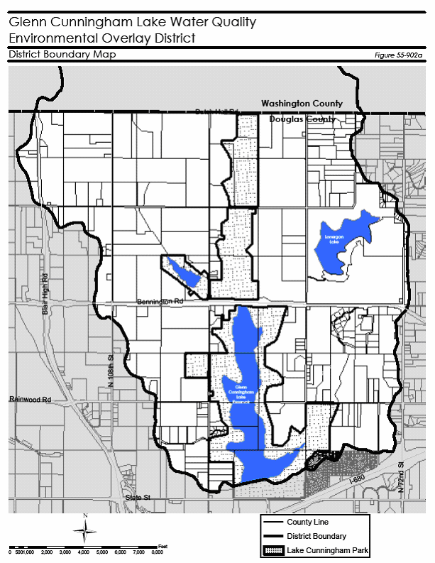
Figure 55-902a
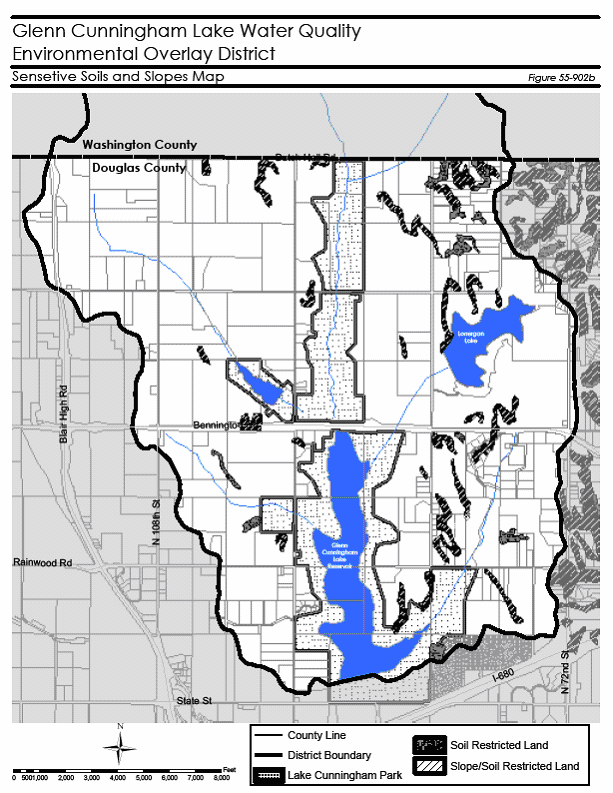
Figure 55-902b
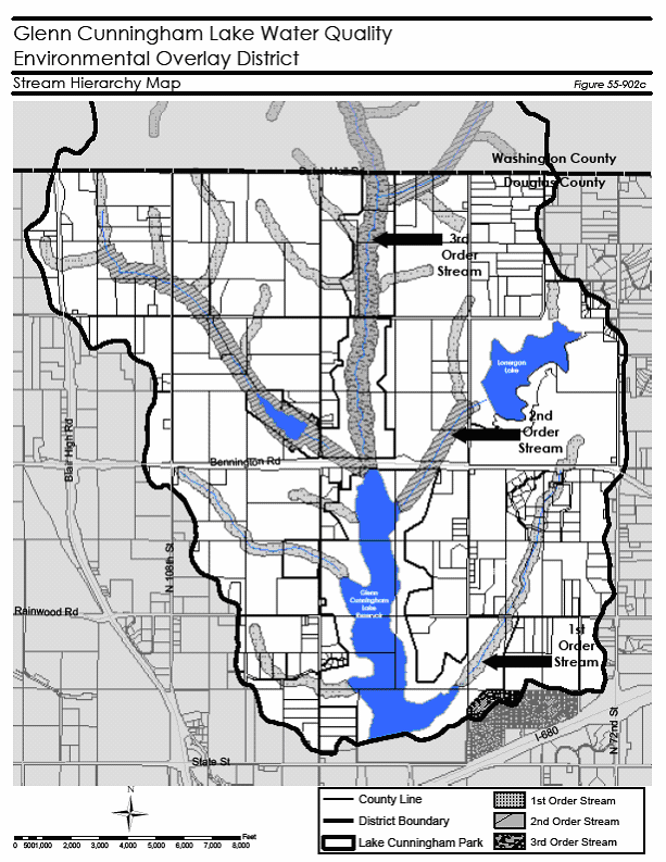
Figure 55-902c
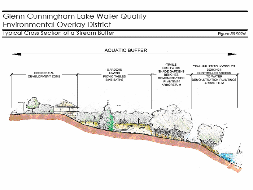
Figure 55-902d
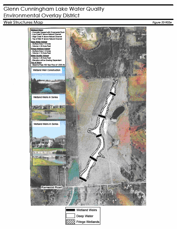
Figure 55-902e
(Ord. No. 38521, § 1, 9-22-09)