Omaha City Zoning Code
ARTICLE II
DEFINITIONS2
Cross reference— Definitions and rules of construction generally, § 1-2.
Sec. 55-11.- Purpose of article.
This article shall be known as the definitions. The purpose of these provisions is to promote consistency and precision in the interpretation of this chapter. The meaning and construction of words as set forth shall apply throughout this chapter, unless modified in a specific section or where the context of such words or phrases clearly indicates a different meaning or construction.
(Code 1980, § 55-11)
Sec. 55-12. - General rules of construction.
The following general rules of construction apply to the text of this chapter:
(a)
Illustrations. In the case of any real or apparent conflict between the text of this chapter and any illustration explaining the text, the text shall apply.
(b)
Conjunctions. Unless the context clearly indicates the contrary, the following conjunctions shall be interpreted as follows:
(1)
"And" indicates that all connected items or provisions apply.
(2)
"Or" indicates that the connected items or provisions may apply singly or in any combination.
(3)
"Either…or" indicates that the connected items or provisions shall apply singly but not in combination.
(c)
Referenced agencies. Unless otherwise indicated, all public officials, bodies and agencies referred to in this chapter are those of the city.
(Code 1980, § 55-12; Ord. No. 33743, § 2, 12-12-95)
Sec. 55-13. - Definitions of terms.
For the purposes of this chapter, certain terms and words are hereby defined. Certain sections contain definitions which are additional to those listed herein. Where terms are not specifically defined, their ordinarily accepted meanings or meanings implied by their context shall apply.
(Code 1980, § 55-13)
Sec. 55-14. - A.
Abutting: Having lot lines or district boundaries in common, including property separated by a public street or alley. Used interchangeably with "adjacent".
Accessory structure: A structure, which is incidental to and customarily associated with a specific principal use or building on the same site.
Accessory use: A use which is incidental to and customarily associated with a specific principal use on the same site.
Addition: Any construction which increases the size of a building or structure in terms of site coverage, height, length, width or gross floor area.
Agent of owner: Any person showing written verification that he/she is acting for, and with the knowledge and consent of a property owner.
Agricultural structures: Structures for agricultural use, including, but not limited to, greenhouses and hoop houses. This definition does not include structures used for general or non-agricultural purposes and typically found on agricultural sites such as sheds.
Building Integrated Agricultural Systems (BIAS): High-performance cultivation systems on and in buildings. BIAS often involve soilless cultivation methods. Systems may include rooftop farming, shipping container farming, vertical farming technology, and waste heat or rainwater capture and reuse.
Permanent agricultural structures: Structures for agricultural use that are erected and in place more than 180 consecutive days. Plumbing, electrical and gas fixtures which require permits are allowed within and attached to the structure.
Raised planting bed: Any planting bed with vertical sides that is open at the top.
Temporary agricultural structures: Structures for agricultural use that are erected and in place no more than 180 consecutive days. Plumbing, electrical and gas fixtures which require permits may be run to areas that are enclosed by a temporary structure but cannot be attached to the structure itself.
Alley: A public right-of-way which is used as a secondary means of access to abutting property.
Alteration: Any construction or physical change in the internal arrangement of spaces, the supporting members, the positioning on a site, or the appearance of a building or structure.
Attached: Having one or more walls in common with a principal building or connected to a principal building by an integral architectural element, such as a covered passageway, façade, wall extension, or archway.
Awning: A temporary or moveable roof like structure supported entirely from the exterior wall of a building that serves as a shelter, as over a storefront, window, door, or deck.
(Code 1980, § 55-14; Ord. No. 38676, § 1, 3-16-10; Ord. No. 43400, § 1, 5-2-23)
Sec. 55-15. - B.
Base district: A district established by this chapter to prescribe basic regulations governing use and site development. No more than one base district shall apply to the same portion of a site.
Beginning of construction: The initial incorporation of labor and materials within the foundation of a building or structure.
Block face: The property abutting one side of a street and lying between the two nearest intersecting streets, or between the one nearest intersecting street and a major physical barrier, including but not limited to railroads, streams, lakes or the city limits.
Block perimeter: The sum of the outside dimensions of a block, measured from the street frontages of the lots comprising the block.
Bufferyard: A landscaped area intended to separate and partially obstruct the view of two adjacent land uses or properties from one another.
Building: A structure having a roof and built to provide shelter, support or enclosure for persons or property.
Building coverage: The area of a site covered by buildings or roofed areas, excluding allowed projecting eaves, balconies and similar features.
Building line: The outer boundary of a building established by the location of its exterior walls.
Building official: The designee of the planning director, responsible for the supervision and operation of the permits and inspections division of the city.
Build-to/set-back: The line located a specified distance from and parallel to the front lot line upon which a specified percentage of the facade of the principal structure facing such lot line must be located.
Build-to/set-back zone: The zone located between two defined distances from and parallel to the front lot line within which a defined percentage of the facade of the principal structure facing such lot line must be located.
Business center: A building containing more than one commercial business, or any group of nonresidential buildings within a common development characterized by shared parking and access.
(Code 1980, § 55-15; Ord. No. 37810, § 10, 8-14-07)
Sec. 55-16. - C.
Canopy: A canopy is an architectural projection that provides protection, identity or decoration, and is supported by the structure to which it is attached and ground mounting, by not less than two stanchions. A canopy comprises a structure over which a covering is attached. Canopies can also stand alone.
Casualty loss: Loss or damage resulting from an unexpected or unforeseen accident or event, as commonly understood or defined in the insurance industry.
Certificate of Occupancy: An official certificate issued by the building official or his/her designee, indicating conformance with the zoning regulations and other applicable ordinances of the city and authorizing legal use of the premises for which it is issued.
Change of use: The replacement of an existing use by a new use.
Cluster: A development design technique that concentrates buildings in specific areas on a site to allow remaining land to be used for recreation, common open space, or the preservation of historically or environmentally sensitive features.
Cluster subdivision: A wholly or principally residential subdivision that permits a reduction in lot area, setback, or other site development regulations, provided there is no increase in the overall density permitted for a conventional subdivision in a given zoning district, and the remaining land area is used for common space.
Collector street: A street connecting neighborhoods within the same communities, designed to carry traffic from local to arterial streets.
Common area: An area held, designed and designated for common or cooperative use within a development.
Common Development: A development proposed and planned as one unified project not separated by a public street or alley.
Compatibility: The degree to which two or more different land use types are able to exist together in close proximity, with no one use having significant negative effects on any other use.
Comprehensive plan: The duly adopted Comprehensive Plan or Master Plan of the City of Omaha, as set forth in Section 7.04 of the City Charter.
Conditional use: A use which is generally compatible with permitted uses in a given zoning district, but has operating and/or physical characteristics that require public review. Conditional uses are subject to special requirements and the discretionary approval of the planning board.
Court: An approved private right-of-way which provides access to residential properties and meets at least three of the following conditions:
(a)
Services 12 or fewer housing units or platted lots;
(b)
Does not function as a local street because of its alignment, design or location;
(c)
Is completely internal to a development;
(d)
Does not exceed 600 feet in length.
CP zoning plan: A plan setting forth, in graphical, tabular and/or textual formats, the specific vehicular and pedestrian access points, building locations (including, without limitation, build-to/set-back lines, minimum heights and location of parking areas) and architectural façade treatments for each of the sites or lots located within a CP civic place overlay district.
(Code 1980, § 55-16; Ord. No. 33743, § 3, 12-12-95; Ord. No. 37810, § 11, 8-14-07; Ord. No. 38676, § 2, 3-16-10)
Sec. 55-17. - D.
Density: The amount of development per specific unit of a site.
Department: The planning department of the city.
Detached: Fully separated from any other building or joined to another building in such a manner as not to constitute an enclosed or covered connection.
Development plan: A plan prepared by the planning department or by the proponent of a project or series of related projects for the coordinated development of a specific area of the city.
Director: If not otherwise specified, the planning director of the city, or his/her designee.
Downtown Omaha: That portion of the city designated on Figure 4 of the land use element of the comprehensive plan as "Regional Mixed-Use Area/Downtown."
Drive-in services: Uses which involve the sale of products or provision of services to occupants in vehicles.
Drive, internal access: A private way or drive that provides access to parking or buildings.
Driveway: A permanently surfaced area providing vehicular access between a street and an off-street parking or loading area.
See Figure 55-32, Street and Drive Types, located at the end of section 55-32.
(Code 1980, § 55-17; Ord. No. 37810, § 12, 8-14-07)
Sec. 55-18. - E.
Easement: A privilege or right of use granted on, above, under or across a particular tract of land by one owner to another.
Enclosed: A roofed or covered space fully surrounded by walls.
(Code 1980, § 55-18)
Sec. 55-19. - F.
Family: One or more persons living together and sharing common living, sleeping, cooking and eating facilities within an individual housing unit, no more than three of whom may be unrelated. The following persons shall be considered related for the purpose of this definition:
(a)
Persons related by blood, marriage or adoption;
(b)
Persons residing with a family for the purpose of adoption;
(c)
Not more than eight persons under 19 years of age residing in a foster house licensed or approved by the state;
(d)
Not more than eight persons 19 years of age or older residing with a family for the purpose of receiving foster care licensed or approved by the state;
(e)
Person(s) living with a family at the direction of a court.
Federal: Pertaining to the government of the United States of America.
Federal aid and primary system: A system of major streets and highways, designated by the metropolitan area planning agency or its successor agency and on file with the planning director.
Floor area ratio: The quotient of gross floor area divided by gross site area.
Frontage: The length of a property line of any one premises abutting and parallel to a public street, private way or court.
(Code 1980, § 55-19)
Sec. 55-20. - G.
Grade: The horizontal elevation of the finished surface of the ground, paving or sidewalk adjacent to any building line.
Green parking area: An area used for off-street parking of vehicles that is designed to provide more shade for pedestrians and vehicles and improve the aesthetic appearance of parking areas.
Green parking space overhang: The surface area between a curb and the front edge of an off-street parking space in a green parking lot.
Gross floor area: The total enclosed area of all floors of a building, measured to the inside surfaces of the exterior walls. This definition excludes the areas of basements, elevator shafts, airspaces above atriums, and enclosed off-street parking and loading areas serving a principal use.
(Code 1980, § 55-20; Ord. No. 37810, § 13, 8-14-07)
Sec. 55-21. - H.
Handicap: The term "handicap" means, with respect to a person, the following:
(a)
A physical or mental impairment which substantially limits one or more of such person's major life activities;
(b)
A record of having such an impairment; or
(c)
Being regarded as having such an impairment; but such term does not include current illegal use of or addiction to a controlled substance (as defined in Section 102 of the Controlled Substances Act (21 USC 802)).
Height: The vertical distance from the established grade to the highest point of the coping of a flat roof, to the deck line of a mansard roof, or to the average height between eaves and ridge for a gable, hip, shed or gambrel roof. Where a building is located on a slope, height shall be measured from the average grade level adjacent to the building.
Home garden: The raising and harvesting of crops outdoors, or within temporary or permanent agricultural structures for personal use on a site with a principal use that is residential.
Home occupation: An accessory occupational use conducted entirely within a dwelling unit by its inhabitants, which is clearly incidental to the residential use of the dwelling unit or residential structure and does not change the residential character of its site.
Housing unit or dwelling unit: A building or portion of a building arranged for and intended for occupancy as an independent living facility for one family, including permanent provisions for cooking.
(Code 1980, § 55-21; Ord. No. 43400, § 1, 5-2-23)
Sec. 55-22. - I.
Impervious coverage: The total horizontal area of all buildings, roofed or covered spaces, paved surface areas, walkways and driveways, and any other site improvements that decrease the ability of the surface of the site to absorb water, expressed as a percentage of site area. The surface water area of pools is excluded from this definition.
Inclusionary housing program: A program utilized by a residential development that incorporates a specific percentage of housing units within the development that are affordable to low- and moderate-income residents.
Intensity rating: A numeric value representing a grouping of use types which possess generally similar operating characteristics, and/or a similar range of effects on surrounding properties.
(Code 1980, § 55-22)
Sec. 55-25. - L.
Landmark district: A landmark heritage preservation district created pursuant to chapter 24 of this Code.
Landscaped area: The area within the boundaries of a given lot, site or common development consisting primarily of plant material.
Perimeter landscaped area: Any required landscaped area that adjoins the exterior boundary of a lot, site or common development.
Interior landscaped area: Any landscaped area within a site exclusive of required perimeter landscaping.
Large retail building: Any building having an elevation greater than 100 feet in length and used primarily for retail uses.
Loading area: An off-street area used for the loading or unloading of goods from a vehicle in connection with the use of the site on which such area is located.
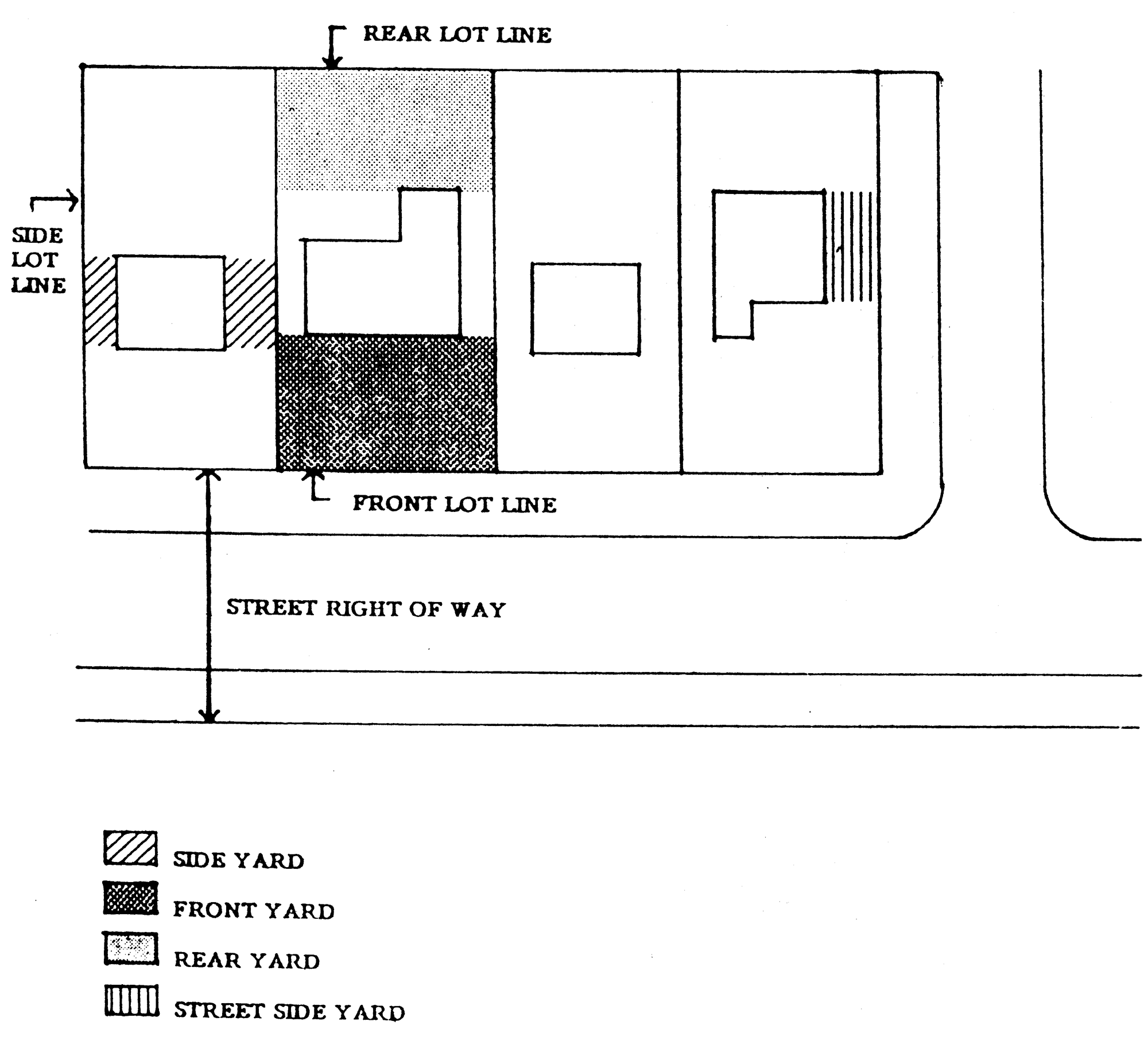
Lot: [See drawing at the end of this article.] A parcel of real property with a separate and distinct number or other designation shown on a plat, record of survey, parcel map, or subdivision map recorded in the office of the county register of deeds. When a lot is used together with one or more contiguous lots in a common development, all of the lots used, including any lots used for off-street parking, shall be considered a single site for purposes of this chapter. A lot shall have a minimum frontage of 20 feet, except as provided in an approved planned unit development and/or cluster subdivision.
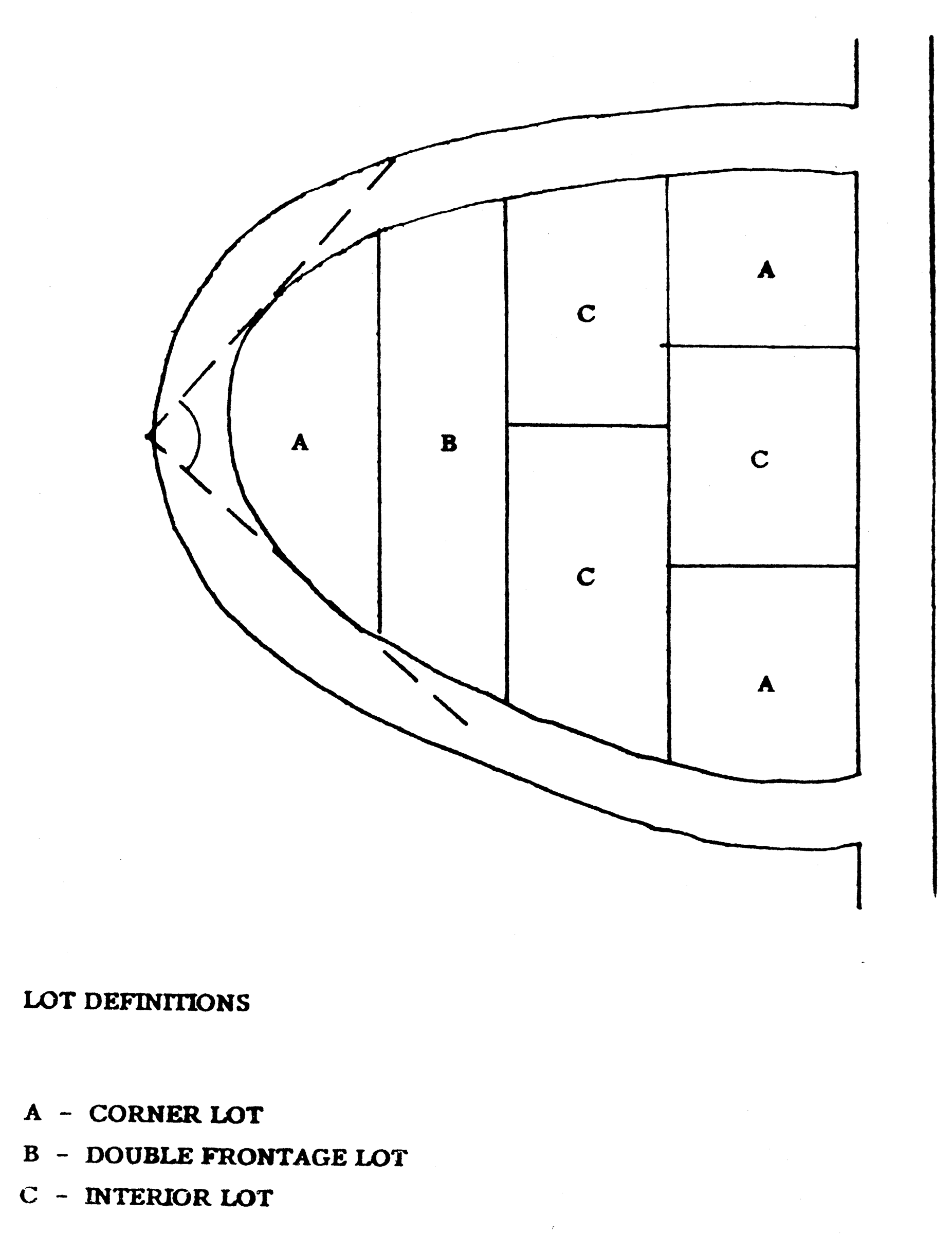
Corner lot: A lot located at the intersection of two streets, private ways or courts or on two segments of a curved street, private way or court forming an angle of no more than 135 degrees.
Double-frontage lot: A lot, other than a corner lot, having frontage on two streets, private ways or courts.
Interior lot: A lot other than a corner lot.
Multiple frontage lot: A lot having frontage on three or more streets, private ways or courts.
Lot area: The total horizontal area within the lot lines of a lot.
Lot depth: The average horizontal distance between the front and rear lot lines.
Lot line: The lines bounding a lot as herein defined.
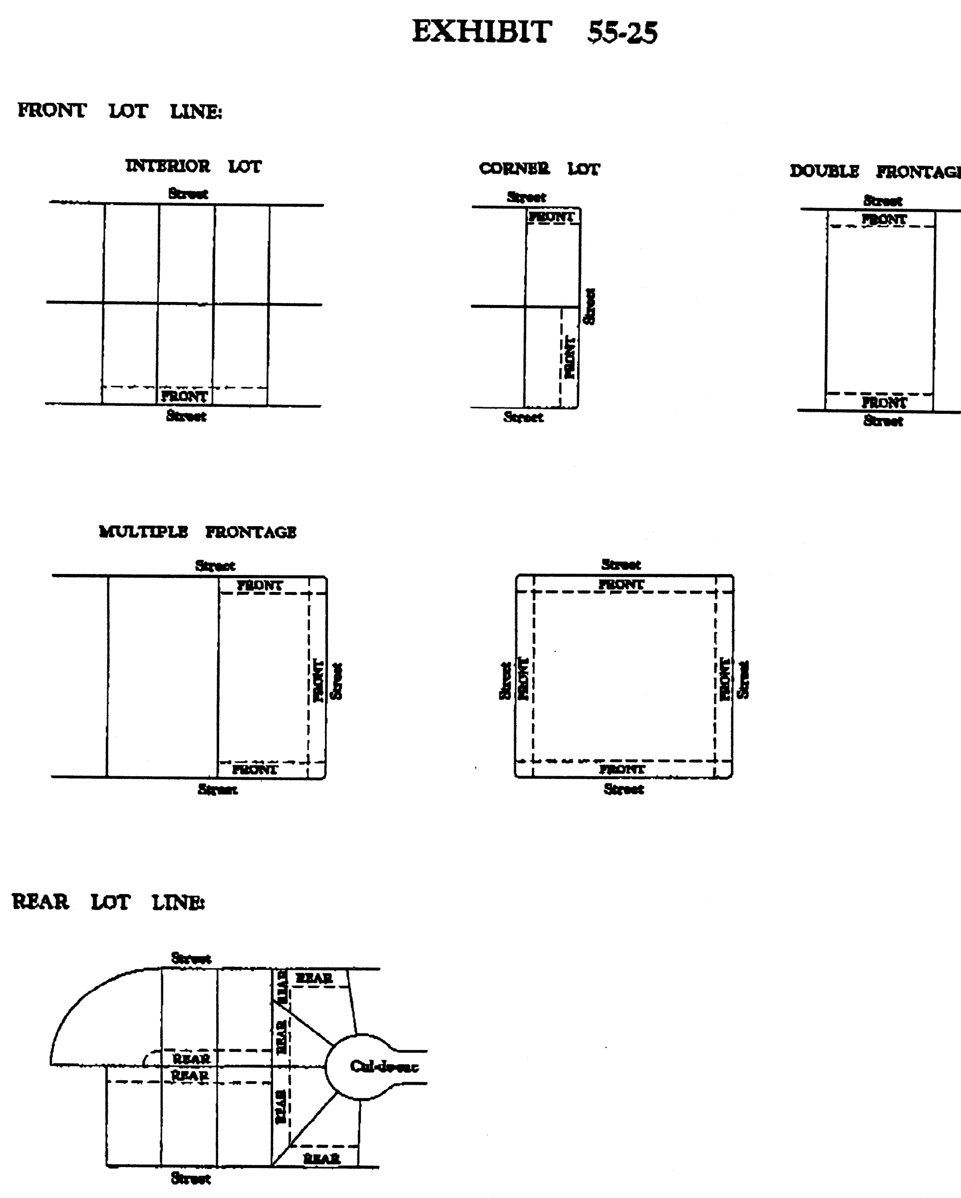
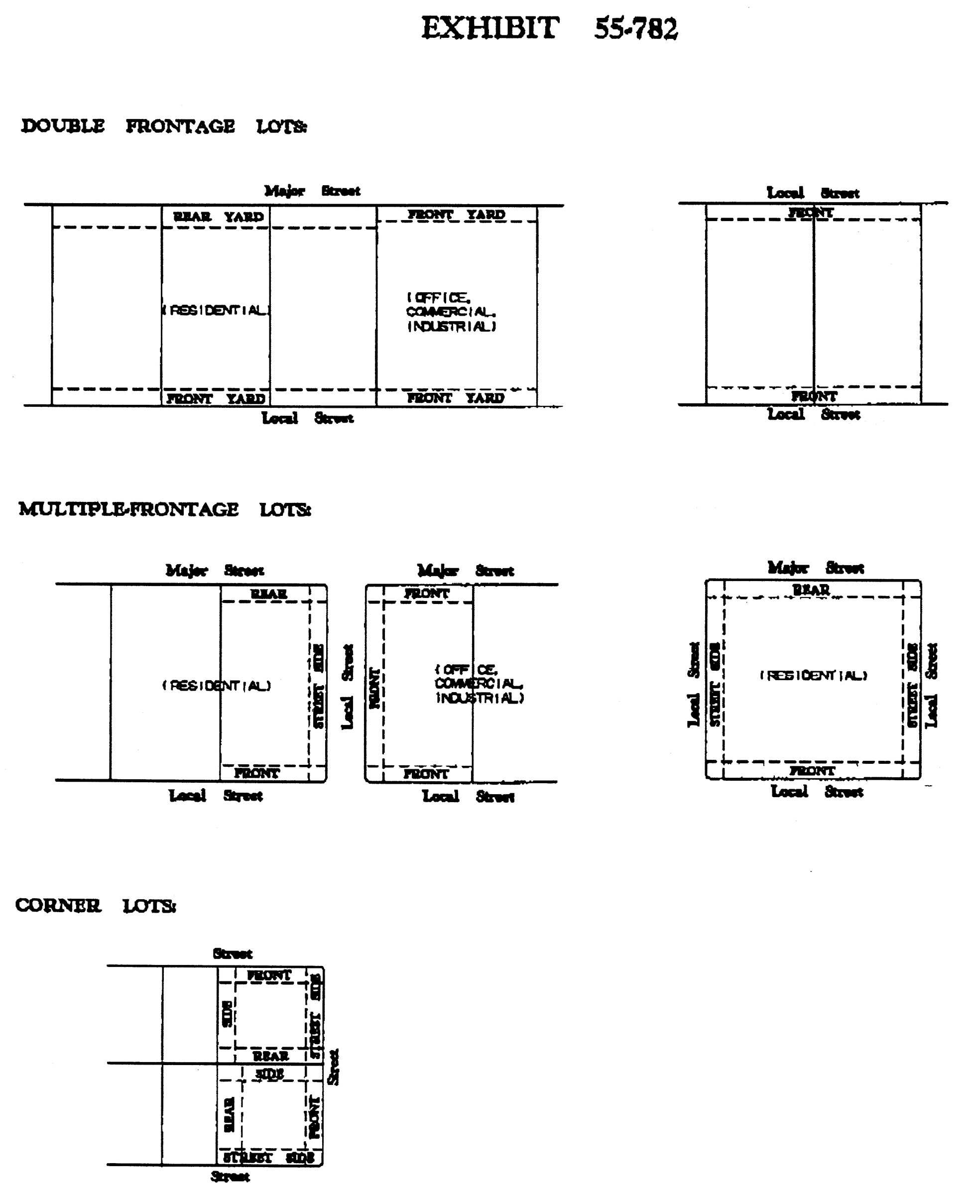
Front lot line: For an interior lot, the lot line separating the lot from the street, private way or court. For a corner lot, the line designated as the front lot line at the time of initial building permit. For a double-frontage lot or multiple frontage lot, the lines separating the lot from all streets, private ways or courts.
Rear lot line: The interior lot line(s) including a point at the intersection of two side lot lines which is opposite and most distant from any adjacent street. (See Exhibit 55-25 at the end of this article).
Side lot line: Any lot line that is neither a front or rear lot line. A side lot line separating a lot from a street, private way or court is a street side lot line. A side lot line separating a lot from another lot or lots is an interior side lot line.
Lot width: The horizontal distance between the side lot lines, measured at the two points of intersection between the front yard setback line and the side lot lines.
(Code 1980, § 55-25; Ord. No. 33100, § 1, 11-2-93; Ord. No. 37810, § 14, 8-14-07)
Sec. 55-26. - M.
Manufactured housing: A factory built structure which is to be used as a place for human habitation, which is not constructed or equipped with a permanent hitch or other device allowing it to be moved other than to a permanent site, which does not have permanently attached to its body or frame any wheels or axles, and which bears a label certifying that it was built in compliance with National Manufactures Home Construction and Safety Standards, 24 CFR3280 et seq., promulgated by the United States Department of Housing and Urban Development, or a modular unit.
Marquee: A permanent roof like structure attached to and supported by a building, often bearing a signboard and projecting over an entrance and may extend over a public right-of-way.
Metro area transit: The operating agency of the transit authority of the city.
Mixed-use area: Each of those areas delineated on Figure 4 of the land use element of the comprehensive plan as a "mixed use area."
Mixed use building: A building or structure which incorporates two or more use types within it.
Mixed use development: A single development which incorporates two or more use types within its site boundaries.
Mobile home: A transportable, factory built structure, designed to be used as a year-round housing unit and built prior to enactment and not bearing a label certifying that it was built in compliance with the National Manufactured Home Construction and Safety Standards, 24 CFR3280 et seq., promulgated by the United States Department of Housing and Urban Development.
Mobile home park: A unified development under single ownership, providing spaces for rent or lease for the placement of mobile home units. Mobile home parks usually include common areas and facilities for management, recreation, laundry, utility services, storage and other services.
Modular housing: A factory-built structure constructed to meet the Uniform Building Code (UBC) and other model building code standards for residential construction (CABO One- and Two Family Dwelling Code) bearing the seal of the Nebraska Department of Health.
(Code 1980, § 55-26; Ord. No. 34026, § 1, 10-29-96; Ord. No. 37810, § 15, 8-14-07; Ord. No. 38676, § 3, 3-16-10)
Sec. 55-27. - N.
Neighborhood conservation/enhancement plan: A plan prepared by or at the direction of the planning department for an area to be designated as an NCE neighborhood conservation/enhancement overlay district.
Nonconforming development: A building, structure or improvement which does not comply with the regulations for its zoning district set forth by this chapter but which complied with applicable regulations at the time of construction.
Nonconforming use: A lawful use of land, other than a sign, which does not comply with the use regulations for its zoning district set forth by this chapter but which complied with applicable regulations at the time the use was established.
Nuisance: An unreasonable and continuous invasion of the use and enjoyment of a property right which a reasonable person would find annoying, unpleasant, obnoxious or offensive.
(Code 1980, § 55-27; Ord. No. 37810, § 16, 8-14-07)
Sec. 55-28. - O.
Open space: Area included on any site or lot that is open and unobstructed to the sky, except for allowed projections of cornices, overhangs, porches, balconies or plant materials.
Overlay district: A district established by this chapter to prescribe special regulations to be applied to a site only in combination with a base district.
Owner: An individual, firm, association, syndicate, partnership or corporation having sufficient proprietary interest to seek development of land.
(Code 1980, § 55-28)
Sec. 55-29. - P.
Parking facility: An area on a lot and/or within a building, including one or more parking spaces, along with provision for access, circulation, maneuvering, and landscaping, meeting the requirements of this chapter. Parking facilities include parking lots, private garages and parking structures.
Parking space: An area on a lot and/or within a building, intended for the use of temporary parking of a personal vehicle. This term is used interchangeably with "parking stall." Each parking space must have a means of access to a public street. Tandem parking stalls in single-family detached, single-family attached, and townhome residential uses shall be considered to have a means of access to a public street.
Permits and inspections division: The permits and inspections division of the planning department.
Permitted use: A land use type allowed as a matter of right in a zoning district, subject only to special requirements of this chapter.
Planned unit development: A development of land which is under unified control and is planned and developed as a whole in a single development operation or programmed series of development stages. The development may include streets, circulation ways, utilities, buildings, open spaces, and other site features and improvements.
Planned unit redevelopment: A development of land which is under unified control that is intended to encourage comprehensive redevelopment within existing residential and commercial areas of the city which is serviced by existing infrastructure. It is designed to achieve a desirable environment through application of flexible and diversified land development standards in an overall site plan. It is further intended to promote economics in land development, maintenance, street systems and utility networks, resulting in the provision of needed housing and the redevelopment of older, less economically viable areas.
Premises: A tract of land consisting of one or more lots or sites which are contiguous and under common ownership or control.
Prevailing build-to/set-back line: The average distance between the street line and the facades of the buildings facing such street line along the same side of the street and the same block, weighted the widths of the lots upon which each such building is located.
Private garage: A building for the storage of motor vehicles where no repair or service facilities are maintained and where no motor vehicles are kept for rental or sale.
Private way: An approved private right-of-way which provides primary access to one or more properties along its continuous length and is not otherwise defined as a court.
Project: The carrying out of any building activity (excluding interior alterations) which requires a building permit.
Property line: The line separating parcels under different ownerships or between different developments.
Public improvements plan: A plan setting forth the public improvements, including, without limitation, public streets, parking areas, utilities and streetscapes, to be undertaken by the city or the state within a CP civic place overlay district.
(Code 1980, § 55-29; Ord. No. 37810, § 17, 8-14-07; Ord. No. 40041, § 2, 7-15-14)
Sec. 55-31. - R.
Recreational vehicle: A vehicle towed or self-propelled on its own chassis or attached to the chassis of another vehicle and designed or used for temporary dwelling, recreational or sporting purposes. Recreational vehicles include but are not limited to travel trailers, campers, motor coach homes, converted buses and trucks, boats, and boat trailers.
Recycling collection point: An accessory use approved by the public works and planning departments that serves as a neighborhood drop-off point for temporary storage of recoverable resources. Such recoverable resources shall be limited to those items customarily used and disposed of by homes and offices and shall further be limited to paper and paper products and containers such as cans, bottles, and jars associated with such home and office uses.
Regulation: A specific requirement set forth by this chapter which must be followed.
Remote parking: A supply of off-street parking at a location not on the site of a given development.
(Code 1980, § 55-31)
Sec. 55-32. - S.
Screening: The method by which a view of one site from another adjacent site is shielded, concealed or hidden. Screening techniques include fences, walls, hedges, berms or other features.
Setback: A line within a lot parallel to and measured from a corresponding lot line, forming the boundary of a required yard and setting forth the nearest that a building face may come to that lot line.
Sign: A symbolic, visual device fixed upon a building, vehicle, structure or parcel of land, which is intended to convey information about a product, business, activity, place, person, institution, candidate or political idea.
Site: The parcel of land to be developed or built upon. A site may encompass a single lot, a portion of a lot, or a group of lots developed as a common development. A site must be in one base district, and cannot be separated by a public street or alley.
Site plan: A plan, prepared to scale, showing accurately and with complete dimensioning the boundaries of a site and the location of all buildings, structures, uses, and principal site development features proposed for a specific parcel of land.
Special permit use: A use with operating and/or physical characteristics different from those of permitted uses in a given zoning district which may, nonetheless, be compatible with those uses under special conditions and with adequate public review. Special permit uses are allowed in a zoning district only at the discretion of and with the explicit permission of the city council.
State: The State of Nebraska.
Street: A right-of-way, dedicated to public use, which affords a primary means of access to the abutting property.
Street, collector: A street that connects local streets to the major street system, generally serving residential neighborhoods or commercial or industrial areas, with direct access to abutting land uses. Traffic demands are generally in the range of 2,000 to 10,000 vehicles per day.
Street, internal: A public or private street that provides for pedestrian and vehicular circulation within and connection through an MU district to adjacent development.
Street, internal main: A public or private street that has buildings fronting on it and on which on-street parking is allowed.
Street, local: A street which is used primarily for access to the abutting properties.
Street, major: An arterial street intended to serve large volumes of traffic for both the municipal and metropolitan area of the city, as defined below:
Arterials and expressways: A street designed to provide continuity between inter- and intra-regional traffic, generally serving major centers of activity, with service to abutting land uses secondary to the provision of travel service. Traffic demands are generally in excess of 15,000 vehicles per day.
Minor arterial: A street that interconnects with and augments the arterial and expressway system and provides service to trips of moderate length, and generally distributes traffic to geographic areas smaller than those served by the arterial and expressway system, with emphasis on service to abutting land uses. Traffic demands are generally in the range of 5,000 to 15,000 vehicles per day.
Street, marginal access: A local street or frontage road which is approximately parallel to and adjacent to or part of a major street and provides access to the abutting properties and protection from through traffic.
Structure: Any object constructed or built, the use of which requires location on the ground or attachment to something located on the ground.
See Figure 55-32, Street and Drive Types, located at the end of this definition section.
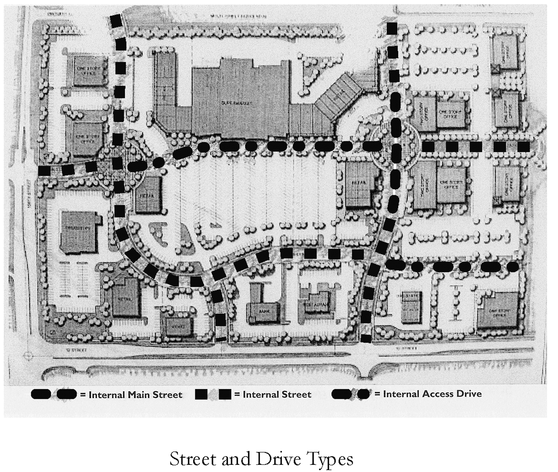
Street and Drive Types
(Code 1980, § 55-32; Ord. No. 37810, § 18, 8-14-07)
Sec. 55-33. - T.
T intersection: The intersection of two streets at which one of the streets does not continue beyond the intersection.
Townhouse: A dwelling unit having a common vertical side wall extending from foundation through roof without openings with or abutting one or more adjacent dwelling units in a townhouse structure, and neither above nor below any other dwelling unit.
Townhouse structure: A building formed by two or more contiguous townhouses with common or abutting walls.
Tree: A woody plant having at least one well-defined trunk or stem and a more or less definitely formed crown, attaining a mature height of at least 15 feet and a width of at least eight feet.
Tree, overstory: A deciduous woody plant having at least one well-defined trunk or stem and a more or less definitely formed crown, attaining a mature height of at least 40 feet and a width of at least 40 feet.
(Code 1980, § 55-33; Ord. No. 37810, § 19, 8-14-07; Ord. No. 43542, § 1, 10-2-23; Ord. No. 44374, § 1, 8-26-25)
Sec. 55-34. - U.
Urban design review board: The urban design review board of the city, created pursuant to article III of chapter 24 of the City's Code.
Use: The conduct of an activity, or the performance of a function or operation, on a site or in a building or facility.
(Code 1980, § 55-34; Ord. No. 37810, § 20, 8-14-07)
Sec. 55-35. - V.
Value: The estimated cost to replace a structure in kind, based on current replacement costs.
(Code 1980, § 55-35)
Sec. 55-38. - Y.
Yard: [See the diagram at the end of this article.] A required open space on a lot adjoining a lot line, containing only landscaping or other uses as provided by this chapter.
Front yard: A required yard extending the full width of a lot, between the front lot line and the front setback line.
Interior side yard: A required yard extending the depth of a lot from the front to rear lot lines, between the interior side lot line and the side setback line.
Rear yard: A required yard extending the full width of a lot, between the rear lot line and the rear setback line.
Street side yard: On a corner lot, a required yard extending the depth of a lot from the front to rear lot lines, between the street side lot line and the street side setback line. On a multiple frontage lot there is no street side yard except as provided in section 55-782.
(Code 1980, § 55-38; Ord. No. 33100, § 2, 11-2-93)
Sec. 55-39. - Z.
Zoning district: A designated specified land classification, within which all sites are subject to a unified group of use and site development regulations set forth in this chapter.
(Code 1980, § 55-39)