
Port Orange City Zoning Code
CHAPTER 17
ZONING DISTRICT REGULATIONS1
Code of Ordinances references—Alcoholic beverages, ch. 6; animals, ch. 10; local business tax, § 18-26 et seq.; noise and light regulations, § 42-76 et seq.
Section 1: - In general.
(a)
Dimensional requirements for each zoning district, except the NP districts, are specified in the table in section 27 of this chapter, entitled "schedule of dimensional requirements."
(b)
Accessory uses and structures for each zoning district are those customarily associated with, dependent on, and incidental to the principle uses permitted in that district. Provisions regarding accessory uses and structures are addressed in chapter 16 of this code.
(c)
Special exception uses for each district shall be permitted in accordance with provisions for such in chapter 18, sections 2 and 3 of this code. The subsection number indicated in parenthesis following each use listed below in this chapter refers to the additional criteria for that use, described in chapter 18, section 3.
(d)
Permitted uses with special development requirements shall be permitted in accordance with the applicable provisions of chapter 18, section 4 of this code. The subsection number indicated in parentheses following each use listed below in this chapter refers to the special development requirements for that use described in chapter 18, section 4.
(e)
No more than one single-family dwelling is permissible on any lot or lot of record within the following zoning districts: Agriculture (A), Agricultural Preservation (AP), Rural Residential (RR), Single-Family Residential (R-20SF), (R-10SF), (R-8SF), (R-7SF), Residential Mobile Home (RMH), Neighborhood Preservation (NP) and Planned Unit Development (PUD), unless specifically stated in the Master Development Agreement.
(f)
Interim permitted use for agriculture uses. Any property that is in agricultural use at the time of rezoning shall be allowed to continue said agriculture uses, including agriculture: field crops/wholesale nurseries and/or agriculture: pasture/forestry, as an interim use on land that has not received final site plan or subdivision approval. However, livestock feeding pens, livestock feed lots, and poultry operations to include any feathered animals (e.g. chickens, emus, ducks, ostriches, etc.) are prohibited within 1,000 feet of proposed or existing development. Agricultural uses on any portion of land rezoned to a nonagricultural zoning category that has received final site plan and/or subdivision approval shall cease within 90 days after such approval.
(g)
All land development regulations related to wireless communications facilities siting, including, but not limited to, a list of zoning districts in which such facilities are a permitted use, are only set forth in chapter 16, section 9 of this code.
(h)
Any use not specifically permitted herein shall be prohibited and any use prohibited by the Florida Statutes, the City of Port Orange, Florida, Code of Ordinances and Land Development Code shall be prohibited.
(Ord. No. 1992-29, 11-3-92; Ord. No. 1995-45, § 1, 12-19-95; Ord. No. 2001-85, § 1, 11-13-01; Ord. No. 2003-6, § 6, 4-22-03; Ord. No. 2011-39, § 3, 1-3-12; Ord. No. 2018-6, § 1, 4-1-18; Ord. No. 2019-5, § 7, 2-5-19; Ord. No. 2021-15, § 4, 7-20-21)
Section 2: - Establishment of zoning districts and official zoning atlas.
(a)
Establishment of districts. The incorporated land and water area of the city is hereby divided into zones or districts as set forth in section 3 of this chapter and as shown on the official zoning atlas.
(b)
Official zoning atlas. The official zoning atlas of the city, is hereby adopted and incorporated by reference, and declared to be a part of this code. The official zoning atlas shall bear the date of its adoption and the signature of the mayor, attested to by the city clerk. All references in the land development code to the official zoning map shall be interpreted to mean the official zoning atlas. The boundaries of each district shall be as shown on the official zoning atlas and the district symbols as set out in this code shall be used to designate each district.
(1)
Zoning district boundary changes. After an amendment has been approved by the city council, changes in district boundaries shall be entered on the official zoning atlas. An entry shall be made promptly on the official zoning atlas stating the date, change, and brief description or nature of change, signed by the mayor and attested to by the city clerk.
(2)
Authority as to current zoning status. The official zoning atlas shall be the final authority as to the current zoning status of land and water areas, buildings and other structures in the city, and shall supersede and replace any and all previously adopted zoning maps. The city clerk shall be custodian of the official zoning atlas.
(3)
Interpretation of district boundaries. Where uncertainty exists as to the boundaries of districts as shown on the official zoning atlas, the following rules shall apply:
(a)
Boundaries indicated as approximately following the center lines of public or private rights-of-way shall be construed to follow such center lines.
(b)
Boundaries indicated as approximately following platted lot lines shall be construed as following such lot lines as they exist at the time of the establishment of the district boundary.
(c)
Boundaries indicated as approximately following city limits shall be construed as following city limits as they existed at the time of the establishment of the district boundary.
(d)
Boundaries indicated as following a shoreline shall be construed to follow such shoreline, and in the event of change in the shoreline, shall be construed as moving with the actual shore line.
(e)
Submerged lands, including waters over such submerged land, unless specifically zoned otherwise, are to be construed as being zoned the same as the abutting upland.
(f)
Boundaries indicated as parallel to or extensions of features indicated in items (a) through (e) above, shall be so construed. Distances not specifically indicated on the official zoning atlas shall be determined by the scale of the atlas.
(g)
Where the street or property layout existing on the ground is at variance with that shown on the official zoning atlas, or in other circumstances not covered by items (a) through (f) above, the administrative official shall interpret the district boundaries.
(h)
Boundaries which split a single parcel may be interpreted to lie up to 100 feet from the location determined by scaled measurements from the official zoning atlas, when such atlas is scaled at one inch equals 800 feet, or may be interpreted to lie up to 50 feet from the location determined by scaled measurements from the official zoning atlas, when such atlas is scaled at one inch equals less than 800 feet.
(Ord. No. 1995-45, § 2, 12-19-95; Ord. No. 2000-52, § 1, 11-14-00)
Section 3: - Flood plain-conservation (F-C) district.
(a)
Purpose and intent. The flood plain-conservation (F-C) district is designed to:
(1)
Protect persons and private property from the hazards of flood water inundation and to protect the community from costs which are incurred when urban development occurs in flood plains; and
(2)
Conserve important natural and historic resources for ecological purposes and for the enjoyment and education of future residents.
(b)
Permitted uses.
(1)
Outdoor facilities for civic and public functions.
(c)
Special exception uses (chapter 18, section 3).
(1)
Agricultural uses (subsection 2).
(2)
Recreation (public/private) facilities (subsection 17).
(d)
Construction requirements. Any permanent building, structure, or activity planned in association with uses permitted by right or special exception in this district, shall comply with the requirements specified in chapter 8, article 3, of this code.
(e)
Description of zone.
(1)
Spruce Creek: The area encompassed by the ten-foot contour above mean sea level, west of Strickland Bay.
(2)
Spruce Creek tributaries (except Sweetwater Branch): The area encompassed by the ten-foot contour above mean sea level.
(3)
Sweetwater Branch tributaries: The area encompassed by the ten-foot contour above mean sea level, or the 100-year flood plain elevation, whichever is greater.
(4)
Halifax Canal south of Commonwealth Boulevard: The area encompassed by the five-foot contour above mean sea level on either side of the canal.
(5)
Halifax River, Rose Bay, and Strickland Bay: The area encompassed by the five-foot contour above mean sea level. This will include all of the islands in the Halifax River, except those lands currently zoned otherwise on the Port Orange Causeway. Areas behind existing seawalls at elevations less than five feet may be zoned in conformance with existing development.
(6)
Except where, due to act(s) of nature, ground elevations or the natural community changes from the original conditions that justified F-C district classification of a property, no part of this district shall be rezoned to one of higher use or density. Documentation regarding any such changes must be prepared by qualified consultants and submitted to the department for review and approval.
(Ord. No. 1995-45, §§ 3, 4, 12-19-95; Ord. No. 1998-69, § 1, 10-20-98)
Section 4: - Agricultural preservation (AP) district.
(a)
Purpose and intent. The agricultural preservation (AP) district is intended to preserve prime agricultural lands and provide opportunities for the continuance of agricultural pursuits.
(b)
Permitted uses.
(1)
Agriculture: field crops/wholesale nurseries.
(2)
Agriculture: pasture/forestry.
(3)
Agriculture: processing/hatcheries.
(4)
Commercial stables.
(5)
Single-family detached dwellings.
(bb)
Permitted uses with special development requirements (chapter 18, section 4).
(1)
Kennels (subsection 8).
(2)
Community gardens (subsection 5.1).
(c)
Special exception uses (chapter 18, section 3).
(1)
Cemeteries (subsection 4).
(2)
Farmers/flea markets (subsection 5).
(3)
Houses of worship (subsection 8).
(4)
Mobile homes (subsection 11).
(5)
Retail nurseries and garden supplies (subsection 19).
(6)
Veterinary clinics (subsection 24).
(Ord. No. 1995-45, §§ 5, 6, 12-19-95; Ord. No. 1997-23, § 5, 4-29-97; Ord. No. 1998-69, §§ 2, 3, 10-20-98; Ord. No. 2010-17, § 3, 7-20-10; Ord. No. 2019-5, § 8, 2-5-19)
Section 5: - Agricultural (A) district.
(a)
Purpose and intent. The agricultural (A) district is intended to serve as an interim use agriculture area until development is proposed to a higher intensity land use, as indicated on the future land use map in the comprehensive plan.
(b)
Permitted uses.
(1)
Agriculture: field crops/wholesale nurseries.
(2)
Agriculture: pasture/forestry.
(3)
Commercial stables.
(4)
Single-family detached dwellings.
(bb)
Permitted uses with special development requirements (chapter 18, section 4).
(1)
Kennels (subsection 8).
(2)
Community gardens (subsection 5.1).
(c)
Special exception uses (chapter 18, section 3).
(1)
Cemeteries (subsection 4).
(2)
Farmers/flea markets (subsection 5).
(3)
Houses of worship (subsection 8).
(4)
Private schools (subsection 16).
(5)
Retail nurseries and garden supplies (subsection 19).
(6)
Veterinary clinics (subsection 24).
(Ord. No. 1995-45, §§ 7, 8, 12-19-95; Ord. No. 1997-23, § 6, 4-29-97; Ord. No. 1998-69, §§ 4, 5, 10-20-98; Ord. No. 2010-17, § 3, 7-20-10; Ord. No. 2019-5, § 9, 2-5-19)
Section 6: - Rural residential (RR) single-family residential district.
(a)
Purpose and intent. The rural residential (RR) district is intended to provide low-density residential development in those areas only suitable for such development due to their location adjacent to agricultural areas, environmentally sensitive areas, or existing large lot residential development; or in those areas that, due to their inaccessibility from adequate urban services, fail to justify higher densities.
(b)
Permitted uses.
(1)
Single-family detached dwellings.
(bb)
Permitted uses with special development requirements (chapter 18, section 4).
(1)
Horses (subsection 7).
(2)
Community gardens (subsection 5.1).
(c)
Special exception uses (chapter 18, section 3).
(1)
Houses of worship (subsection 8).
(Ord. No. 1995-45, §§ 9, 10, 12-19-95; Ord. No. 1997-23, § 7, 4-29-97; Ord. No. 1998-69, §§ 6, 7, 10-20-98; Ord. No. 2010-17, § 3, 7-20-10; Ord. No. 2019-5, § 10, 2-5-19)
Section 7: - R-20SF single-family residential district.
(a)
Purpose and intent. The R-20 single-family residential district is intended to serve as a transitional zone between rural low density areas and medium/high density areas, both to protect agricultural pursuits and rural residences as well as to provide for desirable suburban residential densities.
(b)
Permitted uses.
(1)
Single-family detached dwellings.
(bb)
Permitted uses with special development requirements (chapter 18, section 4).
(1)
Community gardens (subsection 5.1).
(Ord. No. 1997-23, § 8, 4-29-97; Ord. No. 1998-69, § 8, 10-20-98; Ord. No. 2010-17, § 3, 7-20-10; Ord. No. 2019-5, § 11, 2-5-19)
Section 8: - R-10SF single-family residential district.
(a)
Purpose and intent. The R-10SF single-family residential district is intended to protect existing suburban development and provide for future development of a similar nature, where locations away from urban activity centers suggest suburban densities.
(b)
Permitted uses.
(1)
Single-family detached dwellings.
(bb)
Permitted uses with special development requirements (chapter 18, section 4).
(1)
Community gardens (subsection 5.1).
(Ord. No. 1997-23, § 9, 4-29-97; Ord. No. 1998-69, § 9, 10-20-98; Ord. No. 2010-17, § 3, 7-20-10; Ord. No. 2019-5, § 12, 2-5-19)
Section 9: - R-8SF single-family residential district.
(a)
Purpose and intent. The R-8SF single-family residential district is intended to provide for smaller lot single-family residences in areas located near urban activity centers.
(b)
Permitted uses.
(1)
Single-family detached dwellings.
(bb)
Permitted uses with special development requirements (chapter 18, section 4).
(1)
Community gardens (subsection 5.1).
(Ord. No. 1997-23, § 10, 4-29-97; Ord. No. 1998-69, § 10, 10-20-98; Ord. No. 2010-17, § 3, 7-20-10; Ord. No. 2019-5, § 13, 2-5-19)
Section 9.5: - R-7SF single-family residential district.
(a)
Purpose and intent. The R-7SF single-family residential district is intended to provide for medium-density, smaller-lot residences in existing neighborhoods located near urban activity centers.
(b)
Permitted uses.
(1)
Single-family detached dwellings.
(bb)
Permitted uses with special development requirements (chapter 18, section 4).
(1)
Community gardens (subsection 5.1).
(c)
Special exception uses (chapter 18, section 3).
(1)
Garage apartments (subsection 7.5).
(2)
Houses of worship (subsection 8).
(3)
Private schools (subsection 16).
(Ord. No. 2001-57, §§ 4, 5, 9-18-01; Ord. No. 2010-17, § 3, 7-20-10; Ord. No. 2019-5, § 14, 2-5-19)
Section 10: - Two-family residential (R-2D) district.
(a)
Purpose and intent. The two-family residential (R-2D) district is intended to provide relatively affordable, urban density housing, and it is intended to serve as a transitional zone between multifamily and single-family residential uses.
(b)
Permitted uses.
(1)
Two-family dwellings.
(bb)
Permitted uses with special development requirements (chapter 18, section 4).
(1)
Community gardens (subsection 5.1).
(2)
Single-family dwellings (subsection 15.6).
(c)
Single-family attached dwelling subdivision regulations.
(1)
Utility easements allowing service to each unit shall be provided.
(2)
Access easements for maintenance of common walls and other facilities shall be provided.
(3)
Legal covenants, restrictions and similar provisions for the joint maintenance of structure shall be submitted to the department to be recorded contemporaneously with the plat.
(4)
Where two-family dwelling development is proposed, plans shall be presented for both units simultaneously.
(Ord. No. 1997-23, §§ 11, 12, 4-29-97; Ord. No. 1998-69, § 11, 10-20-98; Ord. No. 2010-17, § 3, 7-20-10; Ord. No. 2014-26, § 1, 12-2-2014; Ord. No. 2019-5, § 15, 2-5-19)
Section 11: - Low density multifamily residential (R-3L) district.
(a)
Purpose and intent. The low density multifamily residential (R-3L) district is intended to provide low density multifamily development on relatively large tracts of land in single or common ownership.
(b)
Permitted uses.
(1)
Multifamily dwellings (eight units per gross acre maximum allowable density).
(bb)
Permitted uses with special development requirements (chapter 18, section 4).
(1)
Assisted living facilities (subsection 1).
(2)
Child care centers (subsection 4).
(3)
Clubs, lodges, and fraternal organizations (subsection 5).
(4)
Nursing homes (subsection 10).
(5)
Community gardens (subsection 5.1).
(c)
Special exception uses (chapter 18, section 3).
(1)
Houses of worship (subsection 8).
(2)
Private schools (subsection 16).
(d)
Project access. Any R-3L district development shall have direct access to an arterial or collector road as designated under the functional classification system in the comprehensive plan.
(e)
Building spacing requirements. Twenty-five feet between sides of buildings, 25 feet between sides and rears of adjacent buildings, 25 feet between fronts and sides of buildings, 50 feet between any combination of fronts or rears of adjacent buildings.
(Ord. No. 1995-45, §§ 11, 12, 12-19-95; Ord. No. 1997-23, §§ 13, 14, 4-29-97; Ord. No. 1998-69, §§ 12, 13, 10-20-98; Ord. No. 2010-17, § 3, 7-20-10; Ord. No. 2019-5, § 16, 2-5-19)
Section 12: - Moderate density multifamily residential (R-3M) district.
(a)
Purpose and intent. The moderate density multifamily residential (R-3M) district is intended to provide moderate density multifamily development on relatively large tracts of land in single or common ownership.
(b)
Permitted uses.
(1)
Multifamily dwellings (12 units per gross acre maximum allowable density).
(bb)
Permitted uses with special development requirements (chapter 18, section 4).
(1)
Assisted living facilities (subsection 1).
(2)
Child care centers (subsection 4).
(3)
Clubs, lodges, and fraternal organizations (subsection 5).
(4)
Nursing homes (subsection 10).
(5)
Community gardens (subsection 5.1).
(c)
Special exception uses (chapter 18, section 3).
(1)
Houses of worship (subsection 8).
(2)
Private schools (subsection 16).
(d)
Project access. Any R-3M district development shall have direct access to an arterial or major collector road as designated under the functional classification system in the comprehensive plan.
(e)
Building spacing requirements. Twenty-five feet between sides of buildings, 25 feet between sides and rears of adjacent buildings, 25 feet between fronts and sides of buildings, 50 feet between any combination of fronts or rears of adjacent buildings.
(Ord. No. 1995-45, §§ 13, 14, 12-19-95; Ord. No. 1997-23, §§ 15, 16, 4-29-97; Ord. No. 1998-69, §§ 14, 15, 10-20-98; Ord. No. 2010-17, § 3, 7-20-10; Ord. No. 2019-5, § 17, 2-5-19)
Section 13: - High density multifamily residential (R-3H) district.
(a)
Purpose and intent. The high density multifamily residential (R-3H) district is intended to provide high density multifamily development on relatively large tracts of land in single or common ownership.
(b)
Permitted uses.
(1)
Assisted living facilities.
(2)
Multifamily dwelling (16 units per gross acre maximum allowable density).
(bb)
Permitted uses with special development requirements (chapter 18, section 4).
(1)
Child care centers (subsection 4).
(2)
Clubs, lodges, and fraternal organizations (subsection 5).
(3)
Nursing homes (subsection 10).
(4)
Community gardens (subsection 5.1).
(c)
Special exception uses (chapter 18, section 3).
(1)
Houses of worship (subsection 8).
(2)
Private schools (subsection 16).
(d)
Project access. Any R-3H district development shall have direct access to an arterial road as designated under the functional classification system in the comprehensive plan.
(e)
Building spacing requirement. Twenty-five feet between sides of buildings, 25 feet between sides and rears of adjacent buildings, 25 feet between fronts and sides of buildings, 50 feet between any combination of fronts or rears of adjacent buildings.
(Ord. No. 1995-45, §§ 15, 16, 12-19-95; Ord. No. 1997-23, §§ 17, 18, 4-29-97; Ord. No. 1998-69, §§ 16, 17, 10-20-98; Ord. No. 2010-17, § 3, 7-20-10; Ord. No. 2019-5, § 18, 2-5-19)
Section 15: - Neighborhood preservation (NP) district.
(a)
Purpose and intent. The neighborhood preservation district is designed to preserve the character, housing mix and density of existing older mixed use neighborhoods by providing for compatible infill development and redevelopment, where enforcement of the dimensional requirements of other conventional and contemporary residential zoning districts would not be possible.
(b)
Permitted uses.
(1)
Single-family detached dwellings.
(bb)
Permitted uses with special development requirements (chapter 18, section 4).
(1)
Assisted living facilities (subsection 1.5).
(2)
Child care centers (subsection 4.5).
(3)
Clubs, lodges, and fraternal organizations (subsection 4.9).
(4)
Garage apartments (subsection 5.5).
(5)
Nursing homes (subsection 10).
(6)
Community gardens (subsection 5.1).
(7)
Multifamily dwellings (subsection 9.8).
(8)
Two-family dwellings (subsection 18).
(c)
Special exception uses (chapter 18, section 3).
(1)
Houses of worship (subsection 8).
(2)
Private schools (subsection 16.2).
(d)
Dimensional requirements.
(1)
Single-family detached dwellings.
(a)
Minimum lot width and area: A single-family detached dwelling may be constructed on any existing nonconforming lot of record. Subdivision of land for single-family detached use shall comply with the prevailing development pattern and dimensions for such use within a 200-foot radius of the land to be subdivided. Where existing lots of record have been aggregated for existing development, the pattern shall be based on the aggregation of lots rather than the actual plat.
(b)
Front yard setback: The minimum front yard setback shall be determined by the average dimension used for existing structures with 100 feet of the property measured along the same side of the roadway frontage.
(c)
Side corner setback: Where any corner lot does not provide for extra width to accommodate use of the front yard setback on all roadway frontages, a lesser setback consistent with those found in the surrounding area may be allowed. In no case shall the side corner setback be less than 15 feet.
(d)
Side yard setback: The minimum side yard setback shall be five feet for lots less than 75 feet in width, and 7½ feet for lots of 75 feet or greater.
(e)
Rear yard setback: The minimum rear yard setback shall be 25 feet.
(Ord. No. 1991-20, 8-27-91; Ord. No. 1993-58, 1-18-94; Ord. No. 1995-45, §§ 17, 18, 12-19-95; Ord. No. 1998-69, §§ 19—21, 10-20-98; Ord. No. 2001-57, § 6, 9-18-01; Ord. No. 2010-17, § 3, 7-20-10; Ord. No. 2015-14, § 2, 4-21-2015)
Section 16: - Mobile home residential (RMH) district.
(a)
Purpose and intent. The mobile home residential (RMH) district is intended to provide for the establishment of mobile home dwellings in suburban environments.
(b)
Permitted uses.
(1)
Mobile home parks.
(2)
Mobile home subdivisions.
(3)
Mobile homes.
(bb)
Permitted uses with special development requirements (chapter 18, section 4).
(1)
Single-family dwellings (subsection 15.5).
(2)
Community gardens (subsection 5.1).
(c)
Special exception uses (chapter 18, section 3).
(1)
Recreational vehicle parks and campgrounds (subsection 32).
(2)
Urban mobile home parks (subsection 22).
(d)
Mobile home park development standards. A mobile home park shall be entirely enclosed, exclusive of driveways, at its external boundaries by a solid wall, fence, or evergreen hedge not less than six feet in height.
Access roads within a mobile home park shall be paved to a width not less than 24 feet in a common access area of a minimum 40 feet width. Mobile home spaces may abut upon a driveway of not less than 25 feet in width, which shall have unobstructed access to the road within the mobile home park. The sole vehicular access shall not be by alley, and all dead-end driveways shall include adequate vehicular turning space or cul-de-sac. There shall be a minimum front building setback of 25 feet from all streets within the mobile home park.
Mobile homes shall be so harbored on each space so that there shall be at least a 15-foot clearance between mobile homes, provided, however, with respect to mobile homes parked end to end, the end to end clearance shall be not less than 30 feet.
There shall be at least two paved, off-street parking spaces for each mobile home space, which shall be on the same site as the mobile home served, and may be located in the rear or side yard of the mobile home unit.
Each mobile home space shall be provided with a paved patio of at least 200 square feet and having a storage locker of at least 100 cubic feet. Storage lockers may be located in locker compounds.
Sidewalks not less than four feet wide shall be provided along all streets.
Streets, areas at the entrances to buildings used by occupants at night, and walkways shall be lighted with an average illumination of at least three-tenths footcandle.
(e)
Mobile home lot or space requirements. Each mobile home space shall be at least 75 feet wide and 100 feet long and such space shall be clearly defined by permanent markers.
(f)
Mobile home subdivision development requirements. The developer shall prepare and submit plans in accordance with the subdivision regulations of the city.
(g)
Mobile home subdivision, ownership limitations. Any mobile home subdivision in which any person, group or company obtains ownership of ten percent or more of the subdivision units for rental or leasing purposes, shall be deemed to be a mobile home park, and appropriate licenses and/or permits shall be obtained from the city.
Any builder(s), owner(s), or developer(s) of a mobile home subdivision who retains or within a period of 18 months regains possession of ten percent or more of the subdivision units for purposes of rental or lease shall be subject to the regulations of the city governing all aspects of mobile home parks.
(h)
Minimum setbacks for nonconforming mobile home parks. New or replacement mobile homes in existing nonconforming mobile home parks, other than those parks located in Harbor Oaks or Allandale, as described below, shall meet the following setbacks. No setback encroachment shall be permitted for accessory structures such as screen rooms, porches, carports, sheds, or other improvements attached to the mobile home.
(1)
Front and side corner: Twenty feet from the edge of street pavement.
(2)
Side: Ten feet from adjacent mobile homes, accessory structures, and park property lines.
(3)
Rear: Fifteen feet from adjacent mobile homes and accessory structures. Accessory structures shall maintain a ten-foot setback from adjacent mobile homes, accessory structures, and park property lines.
(i)[hh]
[Minimum setbacks within existing nonconforming mobile home parks.] Minimum setbacks within existing nonconforming mobile home parks located within the formerly unincorporated areas of Harbor Oaks and Allandale, and annexed into the city between December 1, 1997 and June 17, 2000, replacement mobile homes shall meet the nonconformance provisions for such parks established in chapter 3, section 8(c). In terms of setback requirements, replacement mobile homes in such parks shall meet the minimum separation distance standards of the National Fire Protection Association (NFPA). No setback encroachment shall be permitted for accessory structures such as screen rooms, porches, carports, sheds, or other improvements attached to the mobile home. The NFPA separation distance standards are as follows:
(1)
Side to side: Ten feet.
(2)
End to side: Eight feet.
(3)
End to end: Six feet.
Units and accessory structures shall maintain a three-foot front yard distance from internal access drives, a five-foot side yard distance from adjacent park boundaries or property lines and a three-foot rear yard distance from adjacent park boundaries or property lines. All units and structures shall be spaced within the park so as to allow sufficient room for a 20-foot wide two-way internal access drive, or a 14-foot wide one-way internal access drive.
(i)
Nonconforming recreational vehicle parks.
(1)
Except as provided in paragraph (2) of this subsection, the owner of a nonconforming recreational vehicle park shall comply with the 180-day limitation on occupancy as provided in chapter 18, subparagraph 3(b)(18)(d) of this code.
(2)
The owner of a nonconforming recreational vehicle park shall be automatically exempt from the 180-day limitation on location of travel trailers on park property or on a specific site within park property. In addition, the owner of a nonconforming recreational vehicle park shall be automatically exempt from the 180-day limitation on occupancy as provided in chapter 18, subparagraph 3(b)(18)(d) of this code, for 25 percent of the travel trailer units within the park.
(a)
The exempt travel trailer units shall be designated by the park owner, who shall keep and maintain records, including occupancy ledgers, reflecting such designation and identifying the units.
(b)
The city and the city's employees, officers and agents shall have the right to enter the park property and review the records required by subparagraph (2)(a) of this subsection and the park premises at such times as the city may require after reasonable notice.
(c)
Notwithstanding the exemption provided by paragraph (2) of this subsection, the park owner shall not construct or install, or allow, suffer or permit the construction or installation of, permanent improvements such as add-a-rooms or patios onto the site of an exempt unit or onto the unit, unless such improvements are permitted under a separate agreement to be executed by the park owner and the city.
(3)
The exemption on occupancy provided by paragraph (2) of this subsection shall automatically and permanently terminate upon the occurrence of any of the following:
(a)
The park owner's failure to keep and maintain records required by subparagraph (2)(a) of this subsection.
(b)
The park owner's refusal to allow the city or its employees, officers or agents to inspect such records or the park premises to ensure compliance with paragraph (2) of this subsection.
(c)
The construction or installation of any improvements prohibited by subparagraph (2)(c) of this subsection.
(d)
The termination of the park's nonconforming status for any of the reasons specified in chapter 3, section 8 of this code. In such instance, the exemption from the 180-day limitation on location of travel trailers provided by paragraph (2) of this subsection shall also terminate.
(4)
The city shall have the authority to enforce violations of this subsection and chapter 18, subparagraph 3(b)(18)(d) of this code, to the extent that the park is not exempt under this subsection.
(5)
Nothing in this subsection is intended to supersede any provision of state law regulating or relating to recreational vehicle parks. Nothing in this subsection is intended to supersede or repeal the park owner's obligation to comply with applicable flood regulations, whether local, state or federal.
(Ord. No. 1993-58, 1-18-94; Ord. No. 1997-39, § 4, 6-24-97; Ord. No. 1997-65, § 1, 1-20-98; Ord. No. 1998-69, § 22, 10-20-98; Ord. No. 2001-85, § 2, 11-13-01; Ord. No. 2002-5, § 2, 2-19-02; Ord. No. 2010-17, § 3, 7-20-10)
Section 17: - Planned unit development (PUD) district.
(a)
Purpose and intent. The planned unit development (PUD) district is intended to provide a flexible approach for unique and innovative land development proposals, which would otherwise not be permitted by this code. Notwithstanding the specific criteria identified herein, proposals should accomplish the following purposes, to the greatest extent possible.
(1)
Provide a variety of housing types with a broad range of housing costs allowing for the integration of differing age groups and socioeconomic classes;
(2)
Promote innovative site and building design, including traditional neighborhood developments;
(3)
Provide efficient location and utilization of infrastructure through orderly and economical development, including a fully integrated network of streets and pedestrian/bicycle facilities;
(4)
Establish open areas set aside for the preservation of natural resources, significant natural features and vistas, and listed species habitats;
(5)
Create usable and suitably located civic spaces, recreational facilities, open spaces and scenic areas;
(6)
Provide for a coherent and visually attractive physical environment through the creation of focal points and vistas, as well as coordination and consistency of architectural styles, landscaping designs and other elements of the built environment; and
(7)
Provide for other limitations, restrictions and requirements as deemed necessary by the city to ensure compatibility with adjacent neighborhoods and effectively reduce potential adverse impacts.
(b)
Unified ownership. All land within the PUD shall be under the ownership or control of the applicant at the time of execution of the master development agreement whether the applicant be an individual, partnership or corporation, or groups of individuals, partnerships or corporations.
(c)
Reserved.
(d)
Open space requirements. Sixty percent of the total project area shall be established and maintained as open space. A minimum of 20 percent of the total project area shall be established and maintained as common open space or common facilities. No area shall be accepted as common open space unless it satisfies the following standards.
(1)
Common open space shall be dedicated to and usable by all residents of the planned unit development or specific phase thereof.
(2)
Common open space shall be suitably improved for its intended use. Such use may include aesthetic, amenity, buffering or recreational purposes, community gardens, or the preservation of natural resources, natural features or listed species habitats.
(3)
Common open space set aside for the preservation of natural features or listed species habitats, or for buffering purposes shall remain undisturbed and be protected by conservation easements dedicated to the city.
(4)
The location, shape, size and character of common open space shall be depicted on the conceptual plan.
(5)
Common open space shall not be used for the construction of any structures other than recreational facilities and incidental maintenance buildings.
(6)
Common open space shall be maintained by the owners association of the planned unit development or specific phase thereof.
(e)
Perimeter setbacks and buffering. Yards for uses abutting the PUD boundary shall not be less than the yard requirements of the zoning district most similar to that portion of the PUD. The planning commission may recommend and the city council may require greater peripheral yards when determined to be necessary to ensure compatibility and harmony between the PUD and adjoining properties.
(f)
Compliance with regulations in effect at the time of development. Unless otherwise specifically described within the master development agreement, final development plans and development permits for uses/structures within the PUD shall comply with regulations, ordinances and resolutions in effect at the time of plan approval or permit application. This provision shall be included in all master development agreements.
(g)
Pre-application conference. Prior to filing for conceptual plan and master development agreement approval, the developer or the developer's representative shall meet with the administrative official or his/her designee(s), in order to verify the steps necessary for application and review, and discuss potential issues regarding the PUD proposal. Comments made at the pre-application conference are totally nonbinding on the formal review of the conceptual plan and master development agreement.
(h)
Application for rezoning.
(1)
Application for conceptual plan and master development agreement approval. Application for conceptual plan and master development agreement approval shall be made to the department utilizing the form provided by the department for that purpose and accompanied by the appropriate review fee. Initial application shall be accompanied by ten copies of the conceptual plan, signed and sealed by a registered engineer, architect, or landscape architect, as required by this code, and five copies of the master development agreement. Conceptual plans shall be prepared according to the standards of this code.
(a)
Review of application materials. Within two working days of the receipt of an application, the department shall determine whether the submittal is complete. Incomplete submittals shall be returned to the applicant with the deficiencies noted in writing. Re-application shall be accompanied by a re-application fee as adopted by resolution of the city council.
(b)
Initiation of development review. When an application is determined to be complete, it shall be scheduled for the next scheduled staff development review committee (SDRC) meeting, but no earlier than one week from the date that the application was determined to be complete.
(2)
Conceptual development plan. Upon application for rezoning to the PUD district, the applicant shall provide a conceptual development plan, drawn at a scale of no smaller than one inch equal to 100 feet. The plan shall show the development potential of the site, including natural and manmade conditions, constraints, and opportunities and contain the following information, when applicable. An asterisk (*) denotes information which may be waived by the applicant for purposes of approval of the conceptual plan exhibit of the master development agreement. If any of the denoted information is not provided, the conceptual plan exhibit shall not be considered to satisfy the requirements for a subdivision conceptual plan, and full compliance with the procedure for approval of the latter shall be required.
(a)
PUD name, date, north arrow, and the legal description, boundary dimensions and area in acreage of the property;
(b)
Name and address of owner, surveyor, engineer, and any other professional consultants involved with the generation of the plan information. If the property is owned by a corporation, company or partnership, the name and address of the president and secretary, and the state of incorporation shall be provided;
(c)
A vicinity map drawn to scale showing the zoning of the area and the relationship of the proposed PUD to surrounding development;
(d)
Proposed common areas, drainage areas, conservation areas, lot lines (*) and lot dimensions (*);
(e)
Proposed street names and lot numbers (*);
(f)
Acreage in lots, drainage areas, common areas, streets and other uses, and the minimum lot size, average lot size (*) and total number of lots (*);
(g)
Existing topography shown in one-foot contours and delineation of flood insurance rate map flood zones;
(h)
Environmental assessment providing delineation of all wetlands, wooded areas, vegetative communities and listed species habitats: general description of the character of such wetlands, wooded areas, vegetative communities and listed species habitats; and a tree survey in accordance with requirements of this code (*);
(i)
The location of existing and proposed buildings, utilities, roads, easements or other improvements on the property, and all roads, lot lines, and abutting property owners within 150 feet of the PUD boundary;
(j)
A soils report including one percolation test per ten acres with one or more eight-foot deep soil boring(s) at each percolation test site (*);
(k)
Statement that compliance with the Land Development Code may necessitate modification of the conceptual plan;
(l)
Soil types, drainage basins and natural drainage patterns;
(m)
General character, size and location of buildings, parking and loading areas, bufferyards and landscaped areas for each proposed land use;
(n)
Site data for each land use and parcel to verify that requirements of the master development agreement have been satisfied;
(o)
General location, size and function of open space areas to verify that requirements of the master development agreement and this section have been satisfied;
(p)
One copy of the computer disk(s) depicting the proposed subdivision layout, including the streets and lots, for projects prepared on an appropriate computer-aided drafting (CAD) system; and
(q)
Any other information deemed pertinent by the department, planning commission or city council.
(3)
Master development agreement. Upon application for rezoning to the PUD district, the applicant shall provide a master development agreement. The agreement shall contain and/or address the following information, when applicable.
(a)
Permitted uses and special exceptions.
(b)
Minimum dimensional requirements. Such requirements shall include lot area and width, setbacks, building height, minimum floor area and any other dimensional information pertinent to the PUD.
(c)
Landscaping, parking and signage requirements when unique or different from those described in this development code.
(d)
Architectural controls. Such controls shall provide for a common architectural theme to be applied to all development within the PUD.
(e)
Project phasing.
(f)
Homeowners association. An association or unified collective of individual associations shall be established to provide for maintenance of common area facilities and to enforce the specific restrictions established by the association.
(g)
Maximum number of dwelling units and overall PUD density.
(h)
Reserved.
(i)
Reserved.
(j)
Improvements to infrastructure which may be required in addition to those specified by this code or at an earlier time than would otherwise be determined by this code.
(k)
Statement that compliance with the environmental preservation code may necessitate modification of the conceptual plan.
(l)
Expiration date.
(m)
Statement of ownership and legal description.
(n)
Any other information deemed pertinent by the department, planning commission or city council.
(i)
Application review process.
(1)
Staff development review committee (SDRC). All applications shall be reviewed by the SDRC, and members' comments shall be delivered and discussed at a regularly scheduled meeting. Formal comments of the SDRC shall be transmitted in writing to the applicant no later than three working days after the meeting.
(2)
Resubmittal of the revised conceptual plan and master development agreement. Resubmittal of the conceptual plan and master development agreement reflecting revisions required by SDRC comments shall be made within one week of the SDRC meeting for expedited processing before the planning commission and city council. The revised plan and agreement may be resubmitted up to one week after a regularly scheduled SDRC meeting for inclusion on the subsequent planning commission agenda, however, no revised plan or agreement shall be submitted later than 60 days after the original SDRC meeting review. The revised conceptual plan and master development agreement shall be reviewed by the appropriate SDRC members, with findings reported by the department to the planning commission for their consideration.
(j)
Approval of application for rezoning.
(1)
Planning commission action. The planning commission shall consider the conceptual plan and master development agreement at a regularly scheduled meeting to determine if the application meets the requirements of this code. Upon consideration of the comments of the SDRC and public, the commission shall take one of the following actions:
(a)
Table the consideration of the application until their next regularly scheduled meeting to allow for the resolution of outstanding issues. No application shall be tabled more than one time in the presence of the applicant by the planning commission.
(b)
Recommend that the application be denied.
(c)
Recommend that the application be approved.
(d)
Recommend that the application be approved with conditions.
(2)
City council approval. The city council shall consider the conceptual plan and master development agreement at a regularly scheduled meeting, and determine if the application meets the requirements of this code. Upon consideration of the comments of the department and public, and the recommendation of the planning commission, the city council shall take one of the following actions:
(a)
Table the consideration of the application to allow for the resolution of outstanding issues.
(b)
Deny the application.
(c)
Remand the application back to the planning commission.
(d)
Approve the application.
(e)
Approve the application with conditions.
(k)
Execution of master development agreement. The second reading of the ordinance for rezoning of any land to the PUD district shall not take place until the developer has provided an executed copy of the master development agreement to the city clerk. The document shall be a fully corrected copy which addresses all issues discussed prior to the scheduled second reading. The document shall also include reduced copies of the revised conceptual plan exhibits. If there are no additional requirements, corrections or conditions attached by the city council at the second reading, the executed document shall be signed by the city clerk and mayor and forwarded to the county clerk for recording. If there are additional requirements, corrections or conditions attached by the city council at the second reading, the applicant shall revise the agreement and conceptual plan and return the documents to the city clerk within 30 days for execution and recording. The requirement to return the document within 30 days shall be specified by the city council as a condition for approval of the rezoning.
(l)
Failure to provide timely resubmission. Failure to meet any of the resubmission deadlines cited above shall require the filing of a new application, including the appropriate review fees.
(1)
Extension of resubmittal deadlines. The administrative official may extend the deadlines cited above, when warranted by unforeseeable events. A request for extension shall be filed in writing with the department explaining the circumstances justifying the extension.
(m)
final development plan approval. Unless otherwise noted within the development agreement, final development approval for subdivisions or site plans within the PUD shall be required in accordance with the general procedures established by this code. Conceptual plan exhibits of the master development agreement which fully satisfy the requirements for conceptual subdivision plan submittal shall be considered as such.
(n)
Expiration of master development agreement. Any master development agreement executed and recorded after the adoption of this development code shall be required to include an expiration date or series of expiration dates tied to specific improvements or phases. Such date(s) shall be determined based upon the size of the project, the installation of physical improvements, and any other factors pertinent to the specific proposal. If the city should determine that the developer has failed to satisfy the requirements necessary to avert expiration, the development agreement shall be considered null and void, and approval of any additional final development plans for the PUD shall not be permitted without resubmission and approval of a new development agreement in accordance with the procedures established in this development code.
(o)
Amendments to the master development agreement and/or conceptual development plan. Subsequent to execution and recording, the master development agreement and/or conceptual development plan may be amended at any time upon mutual agreement of both the city and the appropriate amending party, unless otherwise provided in the agreement. Application for amendment of the master development agreement and/or conceptual development plan shall be made to the department utilizing the form provided by the department for that purpose and accompanied by the appropriate review fee. Initial application shall be accompanied by five copies of the proposed amendment. Upon receipt of the application by the department, the amendment shall be placed on the agenda of the planning commission. Subsequent to action by the planning commission, final review and approval shall be required by the city council.
(p)
Violation of master development agreement or amendment. It is a violation of this code for any person to violate or to refuse or fail to comply with any provision of a development agreement or an amendment to such agreement. Violations may be prosecuted or enforced as provided by law for prosecution or enforcement of municipal ordinances.
(Ord. No. 1993-58, 1-18-94; Ord. No. 1995-45, §§ 21—23, 12-19-95; Ord. No. 1998-69, § 23, 10-20-98; Ord. No. 2010-8, § 2, 5-4-10; Ord. No. 2010-17, § 3, 7-20-10)
Section 18: - Planned commercial development (PCD) district.
(a)
Purpose and intent. The planned commercial development (PCD) district is intended to provide a flexible approach for unique and innovative land development proposals, which would otherwise not be permitted by this code. Notwithstanding the specific criteria identified herein, proposals should accomplish the following purposes, to the greatest extent possible.
(1)
Provide for mixed use commercial, office and industrial development such as shopping centers, office parks, and industrial parks;
(2)
Promote innovative site and building design;
(3)
Provide efficient location and utilization of infrastructure through orderly and economical development;
(4)
Establish open areas set aside for the preservation of natural resources, significant natural features and listed species habitats;
(5)
Provide for a coherent and visually attractive physical environment through coordination and consistency of architectural styles, landscaping designs and other elements of the built environment; and
(6)
Provide for other limitations, restrictions and requirements as deemed necessary by the city to ensure compatibility with adjacent neighborhoods and effectively reduce potential adverse impacts.
(b)
Unified ownership. All land within the PCD shall be under the ownership or control of the applicant at the time of execution of the master development agreement, whether the applicant be an individual, partnership or corporation, or groups of individuals, partnerships or corporations.
(c)
Reserved.
(d)
Perimeter setbacks and buffering. Yards for uses abutting the PCD boundary shall not be less than the yard requirements of the zoning district most similar to that portion of the PCD. The planning commission may recommend and the city council may require greater peripheral yards when determined to be necessary to ensure compatibility and harmony between the PCD and adjoining properties.
(e)
Compliance with regulations in effect at the time of development. Unless otherwise specifically described within the master development agreement, final development plans and development permits for uses/structures within the PCD shall comply with regulations, ordinances and resolutions in effect at the time of plan approval or permit application. This provision shall be included in all master development agreements.
(f)
Pre-application conference. Prior to filing for conceptual plan and master development agreement approval, the developer or the developer's representative shall meet with the administrative official or his/her designee(s), in order to verify the steps necessary for application and review, and discuss potential issues regarding the PCD proposal. Comments made at the pre-application conference are totally nonbinding on the formal review of the conceptual plan and master development agreement.
(g)
Application for rezoning.
(1)
Application for conceptual plan and master development agreement approval. Application for conceptual plan and master development agreement approval shall be made to the department utilizing the form provided by the department for that purpose and accompanied by the appropriate review fee. Initial application shall be accompanied by ten copies of the conceptual plan, signed and sealed by a registered engineer, architect, or landscape architect, as required by this code, and five copies of the master development agreement. Conceptual plans shall be prepared according to the standards of this code.
(a)
Review of application materials. Within two working days of the receipt of an application, the department shall determine whether the submittal is complete. Incomplete submittals shall be returned to the applicant with the deficiencies noted in writing. Re-application shall be accompanied by a re-application fee as adopted by resolution of the city council.
(b)
Initiation of development review. When an application is determined to be complete, it shall be scheduled for the next scheduled staff development review committee (SDRC) meeting, but no earlier than one week from the date that the application was determined to be complete.
(2)
Conceptual development plan. Upon application for rezoning to the PCD district, the applicant shall provide a conceptual development plan, drawn at a scale of no smaller than one inch equal to 100 feet. The plan shall show the development potential of the site, including natural and manmade conditions, constraints, and opportunities, and contain the following information, when applicable. An asterisk (*) denotes information which may be waived by the applicant for purposes of approval of the conceptual plan exhibit of the master development agreement. If any of the denoted information is not provided, the conceptual plan exhibit shall not be considered to satisfy the requirements for a subdivision conceptual plan, and full compliance with the procedure for approval of the latter shall be required.
(a)
PCD name, date, north arrow, and the legal description, boundary dimensions and area in acreage of the property;
(b)
Name and address of owner, surveyor, engineer, and any other professional consultants involved with the generation of the plan information. If the property is owned by a corporation, company or partnership, the name and address of the president and secretary, and the state of incorporation shall be provided;
(c)
A vicinity map drawn to scale showing the zoning of the area and the relationship of the proposed PCD to surrounding development;
(d)
Proposed common areas, drainage areas, conservation areas, lot lines (*) and lot dimensions (*);
(e)
Proposed street names and lot numbers (*);
(f)
Acreage in lots, drainage areas, common areas, streets and other uses, and the minimum lot size, average lot size (*) and total number of lots (*);
(g)
Existing topography shown in one-foot contours and delineation of flood insurance rate map flood zones;
(h)
Environmental assessment providing delineation of all wetlands, wooded areas, vegetative communities and listed species habitats; general description of the character of such wetlands, wooded areas, vegetative communities and listed species habitats; and a tree survey in accordance with requirements of this code (*);
(i)
The location of existing and proposed buildings, utilities, roads, easements or other improvements on the property, and all roads, lot lines, and abutting property owners within 150 feet of the PCD boundary;
(j)
A soils report including one percolation test per ten acres with one or more eight-foot deep soil boring(s) at each percolation test site (*);
(k)
Statement that compliance with the Land Development Code may necessitate modification of the conceptual plan.
(l)
Soil types, drainage basins and natural drainage patterns;
(m)
General character, size and location of buildings, parking and loading areas, bufferyards and landscaped areas for each proposed land use;
(n)
Site data for each land use and parcel to verify that requirements of the master development agreement have been satisfied;
(o)
General location, size and function of open space areas to verify that requirements of the master development agreement and this section have been satisfied;
(p)
One copy of the computer disk(s) depicting the proposed subdivision layout, including the streets and lots, for projects prepared on an appropriate computer-aided drafting (CAD) system; and
(q)
Any other information deemed pertinent by the department, planning commission or city council.
(3)
Master development agreement. Upon application for rezoning to the PCD district, the applicant shall provide a master development agreement. The agreement shall contain and/or address the following information, when applicable.
(a)
Permitted uses and special exceptions.
(b)
Minimum dimensional requirements. Such requirements shall include lot area and width, setbacks, building height, minimum floor area, spacing between buildings, maximum building coverage, minimum landscaped area and any other dimensional information pertinent to the project.
(c)
Landscaping, parking and signage requirements when unique or different from those described in this development code.
(d)
Architectural controls. Such controls shall provide for a common architectural theme to be applied to all development within the PCD.
(e)
Project phasing.
(f)
Landowners association. An association or unified collective of individual associations shall be established to provide for maintenance of common area facilities and to enforce the specific restrictions established by the association.
(g)
Maximum number [of] building lots.
(h)
Reserved.
(i)
Reserved.
(j)
Improvements to infrastructure which may be required in addition to those specified by this code or at an earlier time than would otherwise be determined by this code.
(k)
Statement that compliance with the environmental preservation code may necessitate modification of the conceptual plan.
(l)
Expiration date.
(m)
Statement of ownership and legal description.
(n)
Any other information deemed pertinent by the department, planning commission or city council.
(h)
Application review process.
(1)
Staff development review committee (SDRC). All applications shall be reviewed by the SDRC, and members' comments shall be delivered and discussed at a regularly scheduled meeting. Formal comments of the SDRC shall be transmitted in writing to the applicant no later than three working days after the meeting.
(2)
Resubmittal of the revised conceptual plan and master development agreement. Resubmittal of the conceptual plan and master development agreement reflecting revisions required by SDRC comments shall be made within one week of the SDRC meeting for expedited processing before the planning commission and city council. The revised plan and agreement may be resubmitted up to one week after a regularly scheduled SDRC meeting for inclusion on the subsequent planning commission agenda, however, no revised plan or agreement shall be submitted later than 60 days after the original SDRC meeting review. The revised conceptual plan and master development agreement shall be reviewed by the appropriate SDRC members, with findings reported by the department to the planning commission for their consideration.
(i)
Approval of application for rezoning.
(1)
Planning commission action. The planning commission shall consider the conceptual plan and master development agreement at a regularly scheduled meeting to determine if the application meets the requirements of this code. Upon consideration of the comments of the SDRC and public, the commission shall take one of the following actions:
(a)
Table the consideration of the application until their next regularly scheduled meeting to allow for the resolution of outstanding issues. No application shall be tabled more than one time in the presence of the applicant by the planning commission.
(b)
Recommend that the application be denied.
(c)
Recommend that the application be approved.
(d)
Recommend that the application be approved with conditions.
(2)
City council approval. The city council shall consider the conceptual plan and master development agreement at a regularly scheduled meeting, and determine if the application meets the requirements of this code. Upon consideration of the comments of the department and public, and the recommendation of the planning commission, the city council shall take one of the following actions:
(a)
Table the consideration of the application to allow for the resolution of outstanding issues.
(b)
Deny the application.
(c)
Remand the application back to the planning commission.
(d)
Approve the application.
(e)
Approve the application with conditions.
(j)
Execution of master development agreement. The second reading of the ordinance for rezoning of any land to the PCD district shall not take place until the developer has provided an executed copy of the master development agreement to the city clerk. The document shall be a fully corrected copy which addresses all issues discussed prior to the scheduled second reading. The document shall also include reduced copies of the revised conceptual plan exhibits. If there are no additional requirements, corrections or conditions attached by the city council at the second reading, the executed document shall be signed by the city clerk and mayor and forwarded to the county clerk for recording. If there are additional requirements, corrections or conditions attached by the city council at the second reading, the applicant shall revise the agreement and conceptual plan and return the documents to the city clerk within 30 days for execution and recording. The requirement to return the document within 30 days shall be specified by the city council as a condition for approval of the rezoning.
(k)
Failure to provide timely resubmission. Failure to meet any of the resubmission deadlines cited above shall require the filing of a new application, including the appropriate review fees.
(1)
Extension of resubmittal deadlines. The administrative official may extend the deadlines cited above, when warranted by unforeseeable events. A request for extension shall be filed in writing with the department explaining the circumstances justifying the extension.
(l)
Final development plan approval. Unless otherwise noted within the development agreement, final development approval for subdivisions or site plans within the PCD shall be required in accordance with the general procedures established by this code. Conceptual plan exhibits of the master development agreement which fully satisfy the requirements for conceptual subdivision plan submittal shall be considered as such.
(m)
Expiration of master development agreement. Any master development agreement executed and recorded after the adoption of this development code shall be required to include an expiration date or series of expiration dates tied to specific improvements or phases. Such date(s) shall be determined based upon the size of the project, the installation of physical improvements, and any other factors pertinent to the specific proposal. If the city should determine that the developer has failed to satisfy the requirements necessary to avert expiration, the development agreement shall be considered null and void, and approval of any additional final development plans for the PCD shall not be permitted without resubmission and approval of a new development agreement in accordance with the procedures established in this development code.
(n)
Amendments to the master development agreement and/or conceptual development plan. Subsequent to execution and recording, the master development agreement and/or conceptual development plan may be amended at any time upon mutual agreement of both the city and the appropriate amending party, unless otherwise provided in the agreement. Application for amendment of the master development agreement and/or conceptual development plan shall be made to the department utilizing the form provided by the department for that purpose and accompanied by the appropriate review fee. Initial application shall be accompanied by five copies of the proposed amendment. Upon receipt of the application by the department, the amendment shall be placed on the agenda of the planning commission. Subsequent to action by the planning commission, final review and approval shall be requested by the city council.
(o)
Planned commercial developments formerly zoned C-1 shopping center commercial district (Ordinance No. 33:00, section 710.00 adopted October 9, 1979). Shopping centers and other commercial developments previously zoned C-1 shopping center commercial district under Ordinance 33:00 and developed without an executed master development agreement are subject to the following conditions. Nothing in this subsection shall be construed to limit or restrict specified uses identified within an executed master development agreement.
(1)
Permitted uses.
(a)
Appliance/electronic repair shops.
(b)
Banks.
(c)
Business services.
(d)
Financial services.
(e)
Furniture and appliance services.
(f)
Offices.
(g)
Office supplies.
(h)
Personal services.
(i)
Retail home building materials.
(j)
Retail nurseries and garden supplies.
(k)
Retail sales and services.
(2)
Discretionary uses. Due to the higher number of parking spaces required for the following uses, such may be only permitted by the administrative official if determined that the site development is designed to accommodate the increase in parking. In reviewing whether such uses shall be permitted, the administrative official shall consider a) the number of existing parking spaces and the potential for additions to the parking area; b) the current uses within and parking demand of the site development; c) hours of operation of the proposed use; d) opportunities for shared parking; e) impacts to adjoining properties; f) the existence of other similar uses at the location; and g) any other information deemed significant. Conditions may be imposed on the site development when determined to be necessary by the administrative official.
(a)
Adult/vocational education.
(b)
Game/recreation facilities.
(c)
Health/exercise clubs.
(d)
Restaurants.
(e)
Retail, grocery and drug stores.
(3)
Prohibited uses. The following uses are specifically prohibited for these properties.
(a)
Adult entertainment.
(b)
Bars, lounges and night clubs.
(c)
Boat sales.
(d)
Child care centers.
(e)
Clubs, lodges and fraternal organizations.
(f)
Fortune tellers, astrologers, and palm readers.
(g)
Funeral homes.
(h)
Greenhouses and nurseries (wholesale).
(i)
Hotels/motels.
(j)
House of worship.
(k)
Laundry/dry cleaning plants.
(l)
Mobile home sales.
(m)
Motor vehicle repair facilities.
(n)
Motor vehicle service centers.
(o)
Motor vehicle service stations.
(p)
Pawn shops.
(q)
Tattoo parlors.
(r)
Veterinary clinics.
(p)
Violation of master development agreement or amendment. It is a violation of this code for any person to violate or to refuse or fail to comply with any provision of a development agreement or an amendment to such agreement. Violations may be prosecuted or enforced as provided by law for prosecution or enforcement of municipal ordinances.
(Ord. No. 1993-58, 1-18-94; Ord. No. 1995-45, §§ 24—27, 12-19-95; Ord. No. 1998-69, § 24, 10-20-98; Ord. No. 2010-8, § 3, 5-4-10)
Section 19: - Professional office (PO) district.
(a)
Purpose and intent. The professional office (PO) district is intended to provide areas for business, government, industry, medical, professional, or service offices.
(b)
Permitted uses.
(1)
Business services.
(2)
Financial services.
(3)
Fleet-based services.
(4)
Funeral homes (freestanding uses only).
(5)
Medical office/clinics.
(6)
Offices.
(7)
Veterinary clinics.
(8)
Xerographic and offset printing.
(bb)
Permitted uses with special development requirements (chapter 18, section 4).
(1)
Assisted living facilities (subsection 1.5).
(2)
Banks (subsection 3).
(3)
Child care centers (subsection 4).
(4)
Health/exercise clubs (subsection 6).
(5)
Nursing homes (subsection 1.5).
(6)
Office supplies (subsection 11).
(7)
Office/warehouse facilities (subsection 12).
(8)
Pain management clinics.
(9)
Personal services.
(10)
Restaurants.
(11)
Community gardens.
(c)
Special exception uses (chapter 18, section 3).
(1)
Houses of worship (subsection 9).
(2)
Private schools (subsection 16).
(Ord. No. 1993-58, 1-18-94; Ord. No. 1995-45, §§ 28—30, 12-19-95; Ord. No. 1997-23, §§ 19, 20, 4-29-97; Ord. No. 1998-69, §§ 25, 26, 10-20-98; Ord. No. 2001-83, § 1, 10-16-01; Ord. No. 2010-17, § 3, 7-20-10; Ord. No. 2011-32, § 3, 12-13-11; Ord. No. 2019-5, § 19, 2-5-19)
Section 20: - Neighborhood commercial (NC) district.
(a)
Purpose and intent. The neighborhood commercial (NC) district is intended to provide for limited commercial uses within easy walking and biking distance of residential neighborhoods. Development standards and allowed uses are designed to insure compatibility with adjacent residential uses. Individual NC districts should generally be limited to a maximum area of two acres.
(b)
Permitted uses.
(1)
Beauty/barber shops.
(2)
Convenience stores with or without fuel operations.
(3)
Laundry and dry cleaning retail stores.
(4)
Multi-tenant retail centers of six tenant spaces or less (the maximum size of any tenant space, excluding convenience stores, shall not exceed 2,500 square feet).
(5)
Newsstands/bookstores.
(6)
Offices.
(bb)
Permitted uses with special development requirements (chapter 18, section 4).
(1)
Child care centers (subsection 4).
(2)
Restaurants (subsection (14).
(3)
Community gardens (subsection 5.1).
(c)
Project access. Any NC district development shall have direct access to an arterial or major collector road, as designated in the functional classification system in the comprehensive plan.
(d)
Off-street parking and driveway requirements. No parking area or internal driveways shall be permitted in the front or side yard setbacks. Driveway connections shall be permitted in the front yard setback, in accordance with chapter 12 of this code.
(Ord. No. 1993-58, 1-18-94; Ord. No. 1995-45, §§ 31—33, 12-19-95; Ord. No. 1997-23, §§ 21, 22, 4-29-97; Ord. No. 1998-69, §§ 27, 28, 10-20-98; Ord. No. 2010-17, § 3, 7-20-10; Ord. No. 2019-5, § 20, 2-5-19)
Section 21: - Community commercial (CC) district.
(a)
Purpose and intent. The community commercial (CC) district is intended to provide for community scale businesses that customarily require freestanding buildings on individual sites.
(b)
Permitted uses.
(1)
Adult/vocational education.
(2)
Appliance/electronic repair shops.
(3)
Banks.
(4)
Business services.
(5)
Clubs, lodges, and fraternal organizations.
(6)
Convenience stores with or without fuel operations.
(7)
Financial services.
(8)
Fleet-based services.
(9)
Funeral homes.
(10)
Furniture and appliance stores.
(11)
Health/exercise clubs.
(12)
Medical offices/clinics.
(13)
Motor vehicle service stations.
(14)
Offices.
(15)
Office supplies.
(16)
Personal services.
(17)
Restaurants.
(18)
Retail home building materials.
(19)
Retail nurseries and garden supplies.
(20)
Retail sales and services.
(21)
Veterinary clinics.
(bb)
Permitted uses with special development requirements (chapter 18, section 4).
(1)
Athletic/sports facilities (subsection 2).
(2)
Brewery (subsection 3.7).
(3)
Child care centers (subsection 4).
(4)
Craft food and beverage producer (subsection 5.15).
(5)
Community gardens (subsection 5.1).
(6)
Microbrewery (subsection 9.57).
(7)
Theaters (subsection 17).
(c)
Special exception uses (chapter 18, section 3).
(1)
Bars, lounges, and night clubs (subsection 3).
(2)
Fortune tellers, astrologers, and palm readers (subsection 6).
(3)
Game/recreation facilities (subsection 7).
(4)
Marina, recreational (subsection 9.6).
(5)
Mini-warehouses (subsection 10).
(6)
Motor vehicle and boat storage facilities (subsection 12).
(d)
Project access. Any CC district development shall have direct access to any arterial or major collector road, as designated in the functional classification system in the comprehensive plan.
(Ord. No. 1995-45, §§ 34—36, 12-19-95; Ord. No. 1997-23, §§ 23, 24, 4-29-97; Ord. No. 1998-69, §§ 29, 30, 10-20-98; Ord. No. 2000-53, § 5, 2-20-01; Ord. No. 2010-8, § 4, 5-4-10; Ord. No. 2010-17, § 3, 7-20-10; Ord. No. 2015-34, § 4, 10-6-15; Ord. No. 2016-19, § 2, 10-4-16; Ord. No. 2017-28, § 4, 9-19-17; Ord. No. 2019-5, § 21, 2-5-19)
Section 22: - Highway commercial (HC) district.
(a)
Purpose and intent. The highway commercial (HC) district is intended to provide for highway oriented businesses, regional scale facilities, and those retail uses that are undesirable in close proximity to residential areas.
(b)
Permitted uses.
(1)
Adult/vocational education.
(2)
Appliance/electronic repair shops.
(3)
Athletic/sports facilities.
(4)
Auction houses.
(5)
Banks.
(6)
Bars, lounges, and night clubs.
(7)
Boat sales.
(8)
Business services.
(9)
Commercial/industrial equipment and supplies.
(10)
Convenience stores with or without fuel operations.
(11)
Equipment rental.
(12)
Financial services.
(13)
Fleet-based services.
(14)
Fortune tellers, astrologers, and palm readers.
(15)
Furniture and appliance stores.
(16)
Game/recreation facilities.
(17)
Health/exercise clubs.
(18)
Hotels/motels.
(19)
Maintenance contractors.
(20)
Medical offices/clinics.
(21)
Mobile home sales.
(22)
Motor vehicle and boat storage facilities.
(23)
Motor vehicle sales.
(24)
Motor vehicle service centers.
(25)
Motor vehicle service stations.
(26)
Offices.
(27)
Office supplies.
(28)
Pawn shops.
(29)
Personal services.
(30)
Restaurants.
(31)
Retail home building materials.
(32)
Retail sales and services.
(33)
Tattoo establishment.
(34)
Theaters.
(35)
Truck/trailer/automobile rental.
(bb)
Permitted uses with special development requirements (chapter 18, section 4).
(1)
Brewery (subsection 3.7).
(2)
Community gardens (subsection 1.5).
(3)
Craft food and beverage producer (subsection 5.15).
(4)
Laundry/dry cleaning plants (subsection 9).
(5)
Microbrewery (subsection 9.57).
(6)
Taxidermy (subsection 16).
(c)
Special exception uses (chapter 18, section 3).
(1)
Mini-warehouses (subsection 10).
(2)
Motor vehicle repair facilities (subsection 13).
(d)
Project access. Any HC district development shall be located along or near the intersection of principal arterial roads where not adjacent to major residential areas and along an arterial road where adjacent to industrial areas, based on the functional classification system in the comprehensive plan.
(Ord. No. 1995-45, §§ 37—39, 12-19-95; Ord. No. 1997-23, §§ 25, 26, 4-29-97; Ord. No. 1998-69, §§ 31, 32, 10-20-98; Ord. No. 2004-11, § 3, 6-15-04; Ord. No. 2010-8, § 5, 5-4-10; Ord. No. 2010-17, § 3, 7-20-10; Ord. No. 2011-39, § 4, 1-3-12; Ord. No. 2016-19, § 3, 10-4-16; Ord. No. 2017-16, § 4, 5-16-17; Ord. No. 2017-17, § 2, 5-16-17; Ord. No. 2019-5, § 22, 2-5-19)
Section 22.5: - Interchange commercial development (ICD) district.
(a)
Purpose and intent. The interchange commercial development (ICD) district is intended to provide for a variety of land uses designed to meet the commercial needs of the local community, traveling motorist, and businesses within the adjoining commercial/industrial areas. The district is designed to meet the following objectives:
(1)
Provide for land uses generally situated at interstate interchanges;
(2)
Provide for land uses necessary for the development of sub-regional commercial nodes which serve both Port Orange and surrounding communities;
(3)
Provide for land uses necessary to accommodate the neighborhood and community commercial needs of the nearby residential neighborhoods;
(4)
Provide for the establishment of employment centers which offer professional, technical and skilled opportunities in addition to service-related positions;
(5)
Provide for flexibility to accommodate mixed-use development; and
(6)
Provide for innovative site and building design.
(b)
Permitted uses.
(1)
Athletic/sports facilities.
(2)
Banks.
(3)
Business services.
(4)
Clubs, lodges, and fraternal organizations.
(5)
Convenience stores with or without fuel operations.
(6)
Financial services.
(7)
Fleet-based services.
(8)
Furniture and appliance stores.
(9)
Game/recreation facilities.
(10)
Health/exercise clubs.
(11)
Hotels/motels.
(12)
Medical offices/clinics.
(13)
Motor vehicle service stations.
(14)
Offices.
(15)
Office supplies.
(16)
Personal services.
(17)
Restaurants.
(18)
Retail home building materials.
(19)
Retail nurseries and garden supplies.
(20)
Retail sales and services.
(21)
Tattoo establishment.
(22)
Theaters.
(23)
Veterinary clinics.
(bb)
Permitted uses with special development requirements (chapter 18, section 4).
(1)
Brewery (subsection 3.7).
(2)
Child care centers (subsection 4).
(3)
Craft food and beverage producer (subsection 5.15).
(4)
Community gardens (subsection 5.1).
(5)
Microbrewery (subsection 9.57).
(6)
Office/warehouse facilities (subsection 12.2).
(c)
Special exception uses (chapter 18, section 3).
(1)
Bars, lounges, and night clubs (subsection 3).
(2)
Mini-warehouses (subsection 10.5).
(3)
Motor vehicle repair facilities (subsection 13).
(4)
Truck stops (subsection 21).
(d)
Project access and location. Any ICD district development shall have direct frontage on the roadway which accesses the interstate highway system and be located no more than one-half mile from the intersection of the centerlines of the interstate and the crossing roadway.
(Ord. No. 1993-58, 1-18-94; Ord. No. 1995-45, §§ 40—42, 12-19-95; Ord. No. 1997-23, §§ 27, 28, 4-29-97; Ord. No. 1998-69, §§ 33, 34, 10-20-98; Ord. No. 2010-17, § 3, 7-20-10; Ord. No. 2015-39, § 2, 12-8-15; Ord. No. 2016-19, § 4, 10-4-16; Ord. No. 2017-16, § 5, 5-16-17; Ord. No. 2019-5, § 23, 2-5-19)
Section 23: - Commercial industrial (CI) district.
(a)
Purpose and intent. The commercial industrial (CI) district is intended to provide development of those less intense storage, repair, industrial service and limited manufacturing uses that have fewer potential impacts on surrounding properties, yet are logically segregated from general commercial areas for aesthetic and economic reasons.
(b)
Permitted uses.
(1)
Adult/vocational education.
(2)
Antennas.
(3)
Appliance/electronic repair shops.
(4)
Boat repair, engine.
(5)
Business services.
(6)
Commercial/industrial equipment and supplies.
(7)
Commercial/industrial services.
(8)
Commercial/industrial warehouses.
(9)
Construction and home improvement contractor.
(10)
Fleet-based services.
(11)
Greenhouses and nurseries (wholesale and retail).
(12)
Infrastructure construction contractor's yard.
(13)
Laboratory, research and development.
(14)
Laundry and dry cleaning plants.
(15)
Maintenance contractors.
(16)
Manufacturing: craftsman shops.
(17)
Manufacturing: fabrication.
(18)
Manufacturing: limited.
(19)
Mini-warehouses.
(20)
Motor vehicle and boat storage facilities.
(21)
Motor vehicle repair facilities.
(22)
Motor vehicle service stations.
(23)
Motor vehicle towing and impoundment.
(24)
Offices.
(25)
Taxidermy.
(26)
Transportation services.
(27)
Truck/trailer/automobile rental.
(28)
Wholesalers and distributors.
(c)
Permitted uses with special development requirements (chapter 18, section 4).
(1)
Brewery (subsection 3.7).
(2)
Kennels (subsection 8).
(3)
Health/exercise club (subsection 6).
(4)
Motor vehicle sales (subsection 9.75).
(d)
Special exception uses (chapter 18, section 3).
(1)
Adult entertainment (subsection 1).
(2)
Used motor vehicle parts yards (subsection 23).
(Ord. No. 1991-20, 8-27-91; Ord. No. 1993-58, 1-18-94; Ord. No. 1995-45, §§ 43—45, 12-19-95; Ord. No. 1997-23, §§ 29, 30, 4-29-97; Ord. No. 1998-69, §§ 35, 36, 10-20-98; Ord. No. 2001-34, § 1, 6-19-01; Ord. No. 2015-34, § 5, 10-6-15; Ord. No. 2016-19, § 5, 10-4-16; Ord. No. 2017-17, § 3, 5-16-17; Ord. No. 2017-28, § 5, 9-19-17; Ord. No. 2019-5, § 24, 2-5-19; Ord. No. 2019-28, § 2, 9-5-19)
Section 24: - Light industrial (LI) district.
(a)
Purpose and intent. The light industrial (LI) district is intended to provide development for limited industrial operations engaged in the fabricating, repair, or storage of manufactured goods, where no objectionable by-products of the activity (such as odors, smoke, dust, refuse, electromagnetic interference, noise in excess of that customary to loading, unloading, and handling of goods and materials) are noticeable beyond the lot on which the facility is located. No hazardous materials may be utilized by the industrial operations permitted in this district.
(b)
Permitted uses.
(1)
Airport and related activities.
(2)
Antennas.
(3)
Boat repair, body.
(4)
Boat repair, engine.
(5)
Commercial/industrial warehouse.
(6)
Construction and home improvement contractor.
(7)
Crematoriums.
(8)
Greenhouses and nurseries (wholesale only).
(9)
Infrastructure construction contractor's yard.
(10)
Laboratory, research and development.
(11)
Laundry and dry cleaning plants.
(12)
Manufacturing, craftsman shops.
(13)
Manufacturing, limited.
(14)
Manufacturing, fabrication.
(15)
Manufacturing, processing.
(16)
Motor vehicle repair facilities.
(17)
Motor vehicle towing and impoundment.
(18)
Offices.
(19)
Trucking terminals.
(20)
Wholesalers and distributors.
(c)
Permitted uses with special development requirements (chapter 18, section 4).
(1)
Brewery (subsection 3.7).
(2)
Health/exercise club (subsection 6).
(d)
Special exception uses (chapter 18, section 3).
(1)
Marina, commercial/industrial (subsection 9.5).
(2)
Truck stops (subsection 21).
(Ord. No. 1991-20, 8-27-91; Ord. No. 1993-58, 1-18-94; Ord. No. 1995-45, § 46, 12-19-95; Ord. No. 1997-23, § 31, 4-29-97; Ord. No. 1998-69, § 37, 10-20-98; Ord. No. 2000-53, § 6, 2-20-01; Ord. No. 2008-24, § 1, 9-17-08; Ord. No. 2013-1, § 1, 1-22-13; Ord. No. 2015-24, § 1, 7-7-15; Ord. No. 2015-34, § 6, 10-6-15; Ord. No. 2016-19, § 6, 10-4-16; Ord. No. 2017-28, § 6, 9-19-17; Ord. No. 2019-5, § 25, 2-5-19; Ord. No. 2019-28, § 3, 9-5-19; Ord. No. 2022-19, § 1, 8-2-22)
Section 25: - Ridgewood development (RD) district.
(a)
Purpose and intent. The Ridgewood Development District is designed to encourage the development and redevelopment, modernization, and beautification of the Ridgewood Avenue corridor, while maintaining its traffic capacity, and protecting the integrity of adjoining residential areas. It is intended to accommodate a mixture of office, commercial, warehouse/storage, and limited industrial uses based on a strategy for the corridor.
(b)
Permitted uses.
(1)
Adult/vocational education.
(2)
Appliance/electronic repair shops.
(3)
Athletic/sports facilities.
(4)
Auction houses.
(5)
Banks.
(6)
Boat sales.
(7)
Business services.
(8)
Clubs, lodges, and fraternal organizations.
(9)
Commercial/industrial equipment and supplies.
(10)
Convenience stores with or without fuel operations.
(11)
Equipment rental.
(12)
Financial services.
(13)
Fleet-based services.
(14)
Fortunetellers, astrologers, and palm readers.
(15)
Funeral homes.
(16)
Furniture and appliance stores.
(17)
Greenhouses and nurseries (wholesale and retail).
(18)
Health/exercise club.
(19)
Hotels.
(20)
Houses of worship.
(21)
Laboratory, research and development.
(22)
Maintenance contractors.
(23)
Manufacturing: craftsman shops.
(24)
Manufacturing, limited.
(25)
Medical offices/clinics.
(26)
Mobile home sales.
(27)
Motor vehicle sales.
(28)
Motor vehicle service centers.
(29)
Motor vehicle service stations.
(30)
Offices.
(31)
Pawn shops.
(32)
Personal services.
(33)
Restaurants.
(34)
Retail home building materials.
(35)
Retail sales and services.
(36)
Tattoo establishment.
(37)
Taxidermy.
(38)
Theaters.
(39)
Veterinary clinics.
(40)
Wholesalers and distributors.
(41)
Xerographic and offset printing.
(bb)
Permitted uses with special development requirements (chapter 18, section 4).
(1)
Assisted living facilities (subsection 1).
(2)
Brewery (subsection 3.7).
(3)
Child care centers (subsection 4).
(4)
Community gardens (subsection 5.1).
(5)
Construction and home improvement contractor (subsection 5.12).
(6)
Craft food and beverage producer (subsection 5.15).
(7)
Microbrewery (subsection 9.57).
(8)
Nursing homes (subsection 10).
(c)
Special exception uses (chapter 18, section 3).
(1)
Bars, lounges and night clubs (subsection 3).
(2)
Boat repair, engine (chapter 18, paragraph 3(b)(3.5)).
(3)
Farmers/flea markets (subsection 5.5).
(4)
Game/recreation facilities (subsection 7).
(5)
Manufacturing: fabrication.
(6)
Marina, recreational (subsection 9.6).
(7)
Mini-warehouses (subsection 10).
(8)
Motor vehicle repair facilities (subsection 13).
(9)
Multifamily dwellings (16 units per gross acre maximum allowable density) (subsection 14).
(d)
Reserved.
(e)
Special landscape provisions.
(1)
Special landscape provisions for development within this district are described in chapter 13, specifically subsection 3(c), subsection 3(d)(3), subsection 3(e), subsection 4(b) and subsection 5(d).
(f)
Special signage provisions. Special signage provisions for development within this district are described in chapter 15, specifically subsection 6(b) and subsection 7(c)(1)(b).
(g)
Special vehicular use provisions. The use of alternative surfaces for parking and other vehicular use areas shall be permitted as provided in subsection 6(f)(3) of chapter 12 of this Code.
(h)
Special owner-occupancy provisions. The residential occupancy by a business owner and the owner's family of a structure being used for a permitted use or permitted use with special development requirements shall be permitted as provided in subsection 2(d) of chapter 20 of this Code.
(Ord. No. 1991-20, 8-27-91; Ord. No. 1992-29, 11-3-92; Ord. No. 1993-58, 1-18-94; Ord. No. 1995-45, §§ 47—51, 12-19-95; Ord. No. 1996-33, § 10, 11-19-96; Ord. No. 1997-23, §§ 32, 33, 4-29-97; Ord. No. 1998-69, §§ 38, 39, 10-20-98; Ord. No. 2000-53, § 7, 2-20-01; Ord. No. 2010-8, § 6, 5-4-10; Ord. No. 2010-17, § 3, 7-20-10; Ord. No. 2013-5, § 3, 5-21-13; Ord. No. 2015-45, § 1, 1-5-16; Ord. No. 2016-19, § 7, 10-4-16; Ord. No. 2017-16, § 6, 5-16-17; Ord. No. 2019-5, § 26, 2-5-19; Ord. No. 2019-28, § 4, 9-5-19)
Section 25.5: - Riverwalk Overlay District (ROD).
(a)
Purpose and intent. The Riverwalk Overlay District is designed to promote the development and redevelopment of the Riverwalk Special Character District, in accordance with concepts outlined in the Port Orange Town Center Redevelopment Plan (POTCRP). The POTCRP calls for this area to be redeveloped as "an attractive, inviting and economically successful mixed-use environment that promotes a positive image and identify for the community."
(1)
The purpose of the Riverwalk Overlay District is to allow uses that support these goals, while prohibiting uses which, while normally permitted by the underlying zoning, would be contradictory to the stated goals and vision of the Riverwalk Special Character District and the POTCRP. It is also the intent of the Riverwalk Overlay District to continue to promote the modernization and beautification of the Ridgewood Avenue corridor and to protect the integrity of adjoining residential areas. The Riverwalk Overlay District is intended to accommodate a mixture of office and commercial uses based upon the redevelopment strategy for the Port Orange Town Center. The permitted uses shown are designed to be developed as a combination of uses on a single site, as opposed to conventional single-use, single-site development.
(2)
It is acknowledged that certain properties lying within a portion of the Riverwalk Overlay District are already developed for uses that are prohibited from being established pursuant to the overlay district. It is the express intent of this provision to foster the continued economic viability of existing businesses in the Riverwalk Overlay District by allowing such existing developments to continue as legal, conforming uses. Therefore, properties that were developed with legal, conforming uses prior to the September 28, 2004, effective date of Ordinance No. 2004-28 establishing the Riverwalk Overlay Ordinance shall continue to be deemed and treated for purposes of zoning as legal conforming uses until such time as the underlying or overlay zoning is changed.
(3)
The provision for legal conforming uses described in section 25.5, paragraph (a)(2) shall not apply to property within and east of Ridgewood Avenue and within and north of Dunlawton Avenue. Said property shall be governed by chapter 17, section 30 and the Land Development Code as otherwise applicable.
(b)
Location. The boundaries of the Riverwalk Overlay District shall be as shown on Figure 17, as may be amended from time to time.
17: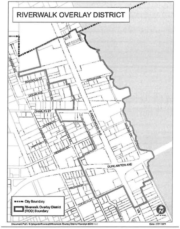
(c)
District regulations. The type of permitted uses or special exceptions allowed shall be determined according to the underlying zoning classification. Additional requirements, allowances and/or restrictions may be found within the regulations for the Riverwalk Overlay District. All proposed projects must comply with any other applicable regulations of the City of Port Orange. When regulations contained within the underlying zoning district conflict with regulations detailed in the Riverwalk Overlay District, the requirements in the Overlay District shall control. For example, a property owner within the Riverwalk Special Character District, whose property has an underlying zoning of "RD" (Ridgewood Development District) wants to open a motor vehicle service station. Motor vehicle service stations are a permitted use within the "RD" zoning district. However, the use is expressly prohibited within the "ROD" (Riverwalk Overlay District). Therefore, the use would not be allowed.
(d)
Reserved.
(e)
Permitted uses with special development requirements (chapter 18, section 4) (RD, CC, PO, PCD without active MDA).
In addition to the uses permitted by the above underlying zoning districts, the following additional use is also permitted with special development requirements within the Riverwalk Overlay District. These additional uses only apply to those properties located having at least one of the above underlying zoning district designations:
(1)
Motor vehicle and boat storage facilities, indoor (subsection 9.77).
(2)
Off-site parking lot (subsection 10.75).
(3)
Outdoor fruit and vegetable or craft markets. (subsection 12.3).
(f)
Prohibited uses. The following uses, otherwise permitted within the RD, CC, PO, and PCD, without an executed master development agreement, and PC-R zoning districts, shall be expressly prohibited as principal uses, with the exception of drive-thru facilities, which shall be prohibited under any circumstance (either as a principal or accessory use), within the Riverwalk Overlay District, unless specifically approved by City Council as part of a PCD:
(1)
Appliance/electronic repairs shops.
(2)
Assisted living facilities.
(3)
Auction houses.
(4)
Boat repair.
(5)
Boat sales.
(6)
Cemeteries.
(7)
Commercial/industrial equipment and supplies.
(8)
Construction and home improvement contractor.
(9)
Convenience stores, with fuel operations.
(10)
Drive-thru facilities.
(11)
Equipment rentals.
(12)
Fleet-based services.
(13)
Fortunetellers, astrologers, and palm readers.
(14)
Funeral homes.
(15)
Greenhouses and nurseries (wholesale and retail).
(16)
Guyed, lattice, camouflaged and monopole communication towers.
(17)
House of worship.
(18)
Hospitals.
(19)
Maintenance contractors.
(20)
Manufacturing: fabrication.
(21)
Mini-warehouses.
(22)
Mobile home sales.
(23)
Motor vehicle repair facilities.
(24)
Motor vehicle sales.
(25)
Motor vehicle service centers.
(26)
Motor vehicle service stations.
(27)
Nursing homes.
(28)
Office/warehouse facilities.
(29)
Outdoor motor vehicle and boat storage facilities.
(30)
Pawn shops.
(31)
Public utility stations/plants.
(32)
Retail home building materials.
(33)
Tattoo establishment.
(34)
Taxidermy.
(35)
Veterinary clinics.
(36)
Wholesalers and distributors.
(37)
Xerographic and offset printing.
(Ord. No. 2004-28, § 3, 9-28-04; Ord. No. 2007-26, § 1, 6-5-07; Ord. No. 2021-26, § 2, 10-5-21)
Section 26: - Government/public use (GPU) district.
(a)
Purpose and intent. The government/public use (GPU) district is intended to provide for public and quasi-public uses in a setting which recognizes the special character and location requirements of such facilities.
(b)
Permitted uses. All uses proposed by any governmental entity or agency thereof shall be permitted in this district. In addition, the following quasi-public uses shall be permitted in this district:
(1)
Adult/vocational education.
(2)
Cemeteries.
(3)
Charitable organization offices.
(4)
Hospitals.
(5)
Houses of worship.
(6)
Nursing homes.
(7)
Private schools.
(8)
Public utility stations/plants.
(bb)
Permitted uses with special development requirements (chapter 18, section 4).
(1)
Child care centers (subsection 4).
(2)
Community gardens (subsection 5.1).
(c)
Special exception uses (chapter 18, section 3).
(1)
Marina, recreational (subsection 9.6).
(d)
Violation of terms or conditions. It is a violation of this code for any person to violate or to refuse or fail to comply with any term or condition of a rezoning or a change of use in the GPU district. Violations may be prosecuted or enforced as provided by law for prosecution or enforcement of municipal ordinances.
(Ord. No. 1991-20, 8-27-91; Ord. No. 1992-29, 11-3-92; Ord. No. 1993-58, 1-18-94; Ord. No. 1995-45, § 52, 12-19-95; Ord. No. 1997-23, §§ 34, 35, 4-29-97; Ord. No. 1998-69, §§ 40, 41, 10-20-98; Ord. No. 2000-53, § 8, 2-20-01; Ord. No. 2004-21, § 1, 9-21-04; Ord. No. 2010-17, § 3, 7-20-10; Ord. No. 2018-26, § 1, 10-16-18; Ord. No. 2019-5, § 27, 2-5-19)
Section 26.5: - Administrative variance procedure.
(a)
In general. The department may grant administrative variance from the dimensional requirements of this chapter when deemed appropriate by the administrative official.
(b)
Application for administrative variances. Application for administrative variances from the dimensional requirements of this chapter shall be made on the appropriate forms provided by the department for that purpose, and shall be accompanied by the appropriate review fee.
(c)
Review criteria. When reviewing any variance request, the administrative official shall consider the following:
(1)
The extent of the variance requested. In no case shall an administrative variance be granted when such variance exceeds ten percent of the required dimension. In such case, the applicant shall be required to make application in accordance with the variance procedure established in chapter 19.
(2)
The review criteria for all other variances described in paragraph 1(g)(2) of chapter 19 of this code.
(Ord. No. 1993-58, 1-18-94)
Section 27: - Schedule of dimensional requirements.
Notes to schedule of dimensional requirements:
(Ord. No. 1995-45, § 53, 12-19-95; Ord. No. 1996-33, § 11, 11-19-96; Ord. No. 2001-57, § 7, 9-18-01; Ord. No. 2008-24, § 1, 9-17-08; Ord. No. 2010-8, § 7, 5-4-10; Ord. No. 2011-29, § 3, 11-8-11; Ord. No. 2015-24, § 1, 7-7-15; Ord. No. 2021-15, § 4, 7-20-21)
Editor's note— Ord. No. 2007-11, § 3, adopted Mar. 20, 2007 states that "the City Council hereby amends Section 27 of Chapter 17 of the Land Development Code, City of Port Orange, Florida as set forth in Attachment 2 to this ordinance." Attachment 2 is not included in this ordinance and at the city's instruction will not be placed into Supplement No. 9.
Section 28: - Planned community (PC) district.
(a)
Purpose and intent. This district is adopted in order to comply with the requirements of the City of Port Orange Planned Community future land use category. This land use category, as articulated in the adopted comprehensive plan, is intended to provide a convenient, flexible way to create integrated mixed-use communities in vacant areas slated for development, as well as in officially designated redevelopment districts where the wholesale redevelopment of large tracts is envisioned.
(b)
Criteria for assignment. The planned community (PC) district is appropriate for areas meeting the following criteria:
(1)
A minimum of 750 areas in size for vacant tracts, or 25 acres in size for officially designed redevelopment districts.
(2)
Adjacent to two or more existing and/or proposed arterial or collector roadways.
(3)
Location within the city's urban service area.
(4)
Abuts or is planned to abut city utilities lines and infrastructure, including potable water, sanitary sewer, and reclaimed water.
(c)
Approval process. The future land use element of the city's comprehensive plan identifies an approval process for property with a future land use designation of planned community, the comprehensive plan further recognizes that the only appropriate zoning for such areas is the PC district. Each area zoned PC shall be permitted to have unique development and zoning standards which control in the event of a conflict with other provisions of this code.
As noted in the comprehensive plan, any area zoned PC shall also have a "Macro Conceptual Development Plan" (Macro CDP). The macro CDP shall depict the overall project boundary, the boundaries and approved land uses of all micro regions (defined below), the existing and planned transportation network, and environmentally sensitive lands as defined in the conservation element of the comprehensive plan. Once an area has been zoned to PC, development within the property shall be approved subject to the requirements of the comprehensive plan and the requirements of this section. The macro CDP for each area zoned PC shall be kept on file with the city.
(1)
Terminology.
(a)
Each property zoned PC, as shown on the conceptual development plan (CDP), shall be referred to as the "macro region".
(b)
The macro region may be broken down into two or more "districts", each with its own development type, such as urban mixed-use, urban residential, suburban residential, commercial, agricultural, etc. Districts each have distinct development requirements, such as setbacks, permitted uses, and architectural design.
(c)
Each district of the macro region may be further divided into smaller "micro regions." Each micro region shall define more specifically the general future use, e.g. "commercial" or "residential up to 8 du/a," within a given portion of a district. The boundaries and general use of each micro region shall be shown on the CDP.
(d)
As development occurs in each "micro region," whether all at once or in phases, it shall be done through the site plan and subdivision process as applicable provided in chapter 3 of this code.
(2)
Micro region approval process. Following the rezoning of an area to PC, all development shall occur by obtaining incremental "micro region and site plan/subdivision" approvals. The micro regions of the property shall be shown on the macro CDP. Each time development is proposed on either all or a portion of a micro region, the following shall be required:
(a)
A micro conceptual development plan (hereinafter, micro CDP).
(b)
Site plan and/or subdivision approval.
The micro CDP shall include the entire micro region. The site plan/subdivision approval shall be required for the part of the micro region where development is proposed.
(3)
Micro conceptual development plan contents. Each micro CDP shall include the following:
(a)
Proposed land uses.
(b)
Internal collector street locations.
(c)
Proposed open space, if any (may refer to park area purchased in lieu of impact fee payment).
(d)
Proposed utility corridors, if any.
(e)
External buffers of the micro region, if any.
(f)
Location of the area in the macro region where development is proposed.
(4)
Site plan/subdivision approval. Development of any portion of a micro region shall require city site plan and subdivision approval as set forth in chapter 3 of this code. Final development plans and development permits for uses and structures shall comply with the regulations, ordinances, and resolutions in effect at the time of plan approval.
(5)
Exemption. A micro CDP shall not be required where development is proposed on an entire micro region of less than 25 acres in size. However, site plan and/or subdivision approval shall still be required.
(6)
Procedures. Micro CDPs shall be reviewed and approved by the administrative official. Subdivision and site plan applications shall be reviewed in accordance with the standards and procedures in chapter 3 of this code.
(7)
Criteria for review of micro CDPs. The applicant shall present a generalized conceptual plan showing that the required infrastructure, per subsection 28(c)(3) above, will be provided with connections to the abutting micro region(s). It is not the intent of the city to require micro CDPs to show the precise location or engineering of the above-listed items within each micro CDP. The city acknowledges that alternative concepts may be reasonable and that the final development of the micro area is not required to be identical to the micro CDP approved by the administrative official.
(d)
Appeals. Appeals regarding decisions of the administrative official and site plan and subdivision applications shall be made as provided in chapter 3, article I, section 6 of this code.
(e)
Amendments. Amendments shall be made in the following manner:
(1)
Site plan/subdivision applications shall be amended as provided in this code.
(2)
A micro CDP shall be amended by filing a new application for the micro region so long as the amendment is consistent with the macro CDP.
(3)
The macro CDP shall be amended in a manner consistent with the current city regulations for zoning amendments. However, boundaries of any micro region may be shifted by the applicant 500 feet in any direction without needing to amend the macro CDP.
(f)
Duration of permits. Developments within PC zoning districts have the potential to be far more complex and take much longer to construct than developments in other zoning districts. This is due in part to their broad mixture of uses, large size, and unique site conditions. Therefore, subdivision development orders obtained for projects in an area zoned PC shall expire five years from the date of issuance. Site plan development orders obtained for the lands in an area zoned PC shall expire three years from the date of issuance. Development order extensions shall be granted as per this code.
(Ord. No. 2002-21, § 7, 5-21-02; Ord. No. 2012-16, § 10, 12-11-2012)
Section 29: - Planned community—Agricultural (PC-A) district.
The following regulations are specifically intended to provide the zoning and development framework for the planned community-agricultural (PC-A) zoning district. This area is identified on the city's future land use map as planned community No. 1. The PC-A zoning district meets the locational criteria identified in section 28(b) above as well as in the future land use element of the city's comprehensive plan. The approved macro CDP for the PC-A zoning district is shown on Figure 17:1.
The entire PC-A zoning district is currently in agricultural use, and said agricultural use shall be allowed to continue as provided herein on an interim basis. The agricultural uses and restrictions are set forth in section 29(f) of this chapter.
(a)
Districts. Given the size of the subject property, and the goals of the city and the landowner, it is necessary to have reasonable flexibility in the zoning regulations for the PC-A zoning district. In order to facilitate flexibility while maintaining reasonable zoning control of the development, the property is divided into four districts with four sets of development guidelines to reflect the unique character and intent of a given area. The four districts are:
(1)
West Town Center District—Located in the northwest quadrant of the PC-A zoning district, immediately east of Tomoka Farms Road.
(2)
Community District—Located to the north and south of the West Town Center District and west of the Workplace District.
(3)
Neighborhood District—Located south of the Community District and west of the Workplace District.
(4)
Workplace District—Located on the west side of I-95, east of the Neighborhood District, Community District, and West Town Center District.
The District boundaries are shown on Figure 17:2.

Figure17-1
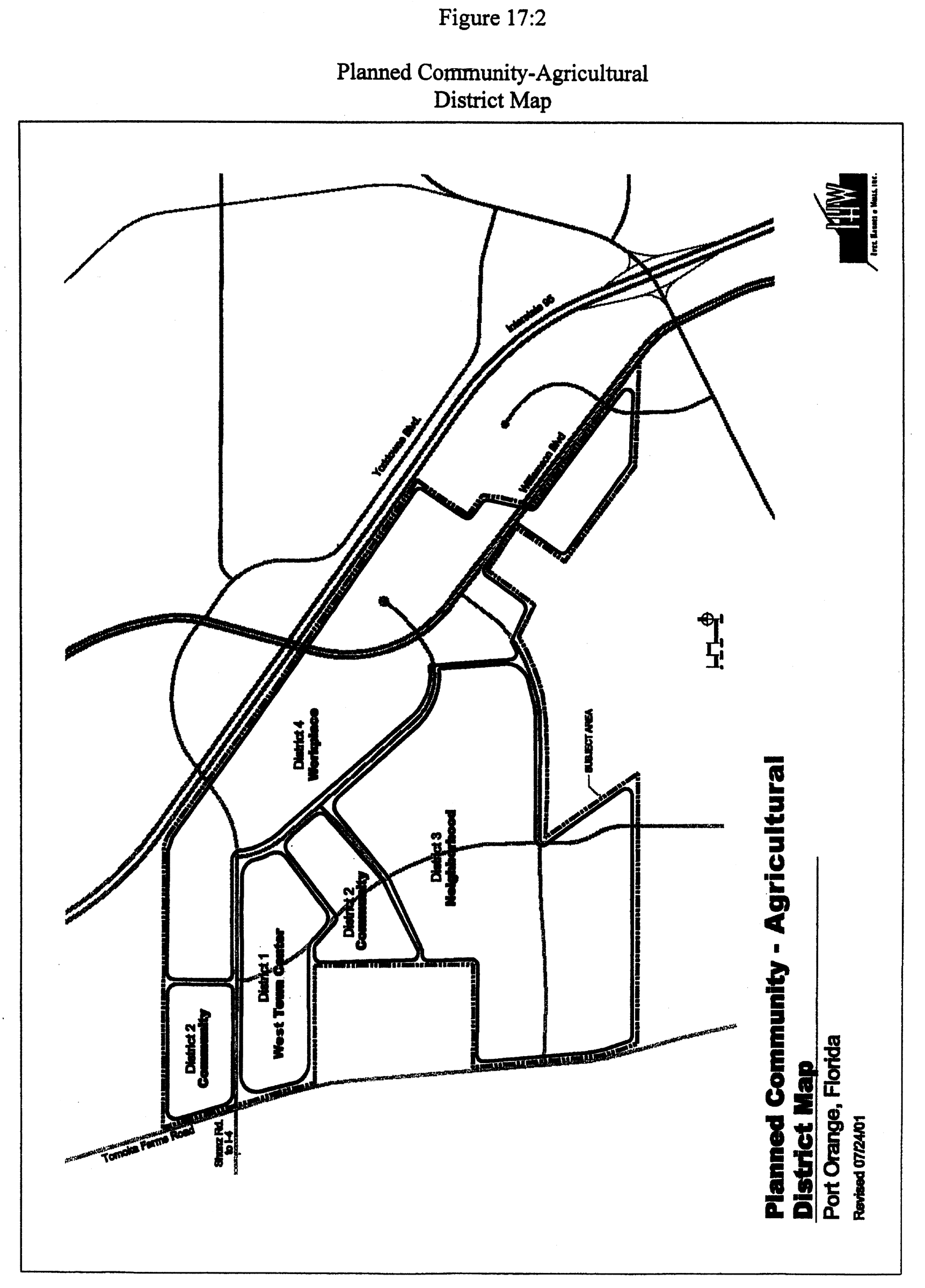
Figure17-2
(b)
West Town Center District.
(1)
Purpose and intent. This district is established to create a compatible mixture of commercial, cultural, educational, governmental uses in a pedestrian-oriented town center. This district will be a focal point for the community and will draw all elements of the project together to form a cohesive mixed-use environment. The West Town Center is dedicated to collective social activity, education, and recreation in a traditional commercial and residential environment which nurtures a unified sense of community.
It is the goal of this district to provide for "traditional town development," bringing together a variety of housing types, offices, shopping and professional services, and public facilities to support a heterogeneous resident population. Planning, design, and development objectives of this district include:
(a)
A strong sense of community identity, based upon a shared, coherent, and functionally efficient mixed-use environment.
(b)
Building, open spaces, and other visual features that act as landmarks, symbols, and activity centers to establish community identity.
(c)
On-street parking and centralized parking facilities to collectively support principal uses in the district.
(d)
A coordinated transportation system with a hierarchy of facilities designed for pedestrians, bicycles, public transit, and the automobile.
(e)
A built environment that is pedestrian-friendly and handicapped-accessible.
(f)
Compatibility of buildings and other improvements as determined by their arrangement, bulk, form, character, landscaping, and architectural style to establish a diverse, livable and harmonious urban form.
(2)
Permitted uses.
(a)
Those uses permitted in the GPU zoning district, as described in section 26 of this chapter, including public schools, post offices, and municipal buildings.
(b)
Agricultural uses as defined by section 29(f).
(c)
Those uses permitted in R-3H, PO, and CC zoning districts, unless specifically prohibited herein.
(d)
Multi-use buildings (provided that the individual uses are approved herein).
(e)
Bed and breakfast inns of less than 10,000 s.f.
(f)
Parking garages.
(g)
Community recreational facilities.
(3)
Permitted uses with special development requirements. Except for those uses prohibited below, permitted uses with special development requirements shall include those in the R-3H, CC, and PO zoning districts. The administrative official shall have the authority to waive any special development requirements for the permitted uses above, as normally required by chapter 18 of this code.
(4)
Special exception uses. Except for those uses prohibited below, special exception uses for the R3-H, PO, and CC zoning districts are also special exception uses in the West Town Center District.
(5)
Prohibited uses.
(a)
Camouflaged and monopole communication towers.
(b)
Cemeteries.
(c)
Drive-through facilities on any building.
(d)
Fleet-based services.
(e)
Guyed and lattice communication towers.
(f)
Kennels or outdoor animal boarding facilities.
(g)
Motor vehicle and boat storage facilities.
(h)
Motor vehicle service stations.
(i)
Single-family detached dwellings.
(j)
Stand-alone convenience stores with fuel operations.
(k)
Warehousing, to include mini-warehousing and office/warehouse facilities.
(l)
Wastewater or water treatment plants.
(6)
Dimensional requirements
1. Towers, widow's walks, parapet walls and rooftop equipment screening may extend a maximum of five feet above the maximum building height.
2. If required landscaping can be met through provision of landscape planters, street trees, etc., then the building coverage may equal 100 percent.
(7)
Residential densities. Residential development shall occur at a maximum density of 16 units per acre. However, the maximum density may be increased to 24 units per acre provided that the developer/applicant can demonstrate to the satisfaction of the administrative official that at least 20 percent of the units will qualify as affordable to low-income families for a period of 15 years.
(8)
Parking. Given the compact, urban, pedestrian-friendly nature of the West Town Center District, a greater percentage of trips are accomplished through non-motorized means than would normally be the case in a pure suburban environment. Therefore, special parking requirements are warranted for the various types of uses in this district. These minimum requirements shall be as follows:
Office—1 space/500 square feet of gross leasable area
Commercial—1 space/400 square feet of gross leasable area
Institutional—1 space/400 square feet of gross finished floor area
Residential—1.5 spaces/unit
Bicycle parking shall be provided as per chapter 12 of this code.
Parking requirements for buildings in this district may be met by demonstrating that parking spaces are available on-street, in shared parking facilities noted on the micro CDP, or in private off-street parking lots.
(9)
Signage. Within this district, signage shall be as provided in chapter 15 of this code.
(10)
Design guidelines. Because of its more urban, rather than suburban nature, the West Town Center District requires specific architectural guidelines in addition to those found in chapter 14 of this code.
(a)
Mix of uses. Development is intended to be mixed-use, in which multiple permitted uses are allowed to take place in a single building. However, in no event shall non-residential uses be allowed over residential uses.
(b)
Urban densities. This district is intended to be developed at an urban scale. Building coverage may equal 100 percent. Infrastructure shall be master-planned to include stormwater management, water and sewer service, parking facilities, and parks/open space.
(c)
Street and block layout. Minor collectors and local streets shall generally be arranged in a linear, gridded network. All streets in this district shall be public streets. The maximum length of blocks shall be 1,000 feet. Alleys may run through the center of each block to provide access to detached garages located at the rear of each residential lot. Alleys may be public or may be privately owned and maintained by a property association.
(d)
Pedestrian friendly. To ensure that the West Town Center District is pedestrian-friendly, the following requirements shall be implemented:
(1)
Landscaping. The West Town Center District shall be landscaped with materials containing a minimum 70 percent native vegetation. The quality and size of all plant materials used shall be as provided in chapter 13 of this code. Landscaping along streets shall include no less than three shade trees every 100 feet. Palm trees, as defined in chapter 13 of this code may be substituted for shade trees, provided that at least two palms are substituted for each shade tree. In either case, the tree type shall be consistent on both sides of the street within each block. Such trees may be placed in the right-of-way through an agreement with the city.
(2)
Water features. Water features, such as fountains, reflecting pools, and aquatic gardens, may be used on site. Lakes smaller than 1,500 s.f. (measured at normal water level) are prohibited unless a decorative fountain is also provided or unless the lake is located at the base of a "waterfall" design feature.
(3)
Street furniture. The use of street furniture is encouraged. Street furniture shall include outdoor seating, kiosks, sculpture, bicycle racks, tree grids, trash receptacles, fountains and telephone booths. Street furniture should be consistent with architectural theme for the balance of the project.
(4)
Lighting. Lighting should be compatible with traditional, architectural styling to include decorative bases, poles, brackets and finials. Poles should be mounted in at-grade concrete footings. Lighting lamps shall be either high-pressure sodium or metal halide. Lighting shall provide security for the residents, visitors, and workers at the West Town Center but shall not create glare to the surrounding neighborhoods. Illumination shall be provided downward vs. outward. Light pole height should not exceed 15 feet. Lighting shall be provided at no more than 50-foot intervals.
(5)
Sidewalks.
(a)
All streets within the West Town Center shall have sidewalks on both sides.
(b)
Sidewalks shall be a minimum of ten feet in width along the north-south collector road, the west side of the north-south arterial road, the south side of the east-west arterial road, and around the town square. Sidewalks shall be a minimum of eight feet in width in all other locations in this district.
(c)
The first four feet of the sidewalk, measured from the face of curb, shall be used for fire hydrants, benches, trash receptacles, newspaper stands, traffic signs, bike racks and light poles.
(d)
Sidewalks at street intersections shall be sloped in such a manner as to accommodate handicapped access with the use of two curb cuts and/or ramps at each street intersection.
(e)
Parking/access.
(1)
Off-street surface parking lots shall be separated from the street by buildings or by decorative brick or stucco walls that are at least three feet in height, measured from the highest finished grade elevation adjacent to the nearest parking space.
(2)
Parking garages shall include architectural treatments compatible with buildings or structures that occupy the same street. Parking garages shall have pedestrian access to the street. Street-front stores and offices on the first floor of parking areas shall be permitted and encouraged.
(3)
On-street parallel or diagonal parking is permitted throughout the West Town Center District.
(4)
To encourage bicycle use, each parking lot or garage shall include at least one bike rack, which will accommodate at least one bicycle per ten required automobile spaces. The bicycle racks shall be located outside of the public right of way. Deferral of required bicycle parking facilities shall be allowed as per chapter 12, section 4(d)(2).
(5)
Driveways on adjacent properties shall be allowed to abut one another. Alternately, adjacent properties shall be allowed to share one or more common driveways, so long as access easements allowing this to occur are submitted to the city for review or are recorded on the subdivision plat for said property.
(f)
Focal point for passive recreation/community involvement.
(1)
The focal point of the West Town Center District shall be a town square. The town square shall measure at least 100 feet by 100 feet, and shall include a community icon such as a fountain, statuary, or large tree.
(2)
There shall be a commons generally running east to west through the district, from the principal north/south arterial road to Tomoka Farms Road. The commons shall intersect the district focal point.
(3)
To promote community cohesiveness, the West Town Center District shall be located near a community park and a series of community pathways to move pedestrians from surrounding areas into the West Town Center District and park.
(g)
Design cohesiveness. Design cohesiveness is required. Certain design elements shall be regulated to achieve cohesiveness, including streetscape transitions, walls, roofs, exterior color and materials, windows and doors, awnings, balconies and signage.
(1)
Streetscape transitions. Height and scale shall be compatible with that of surrounding development. In order to accomplish appropriate facade transitions, and to maximize city streetscape aesthetics, the following transitional techniques shall be applied to new development and redevelopment when within 300 feet of an existing building:
(a)
Buildings shall be designed to provide transitional elements and architectural features (architectural style, scale, design details, construction materials and the like) that are architecturally compatible with adjacent structures. Buildings that are twice the height, or greater, than an adjacent structure shall also provide transitional elements that serve to minimize significant differences in building heights.
(b)
The pattern of placement, proportions and materials of windows and doors shall be harmonious with surrounding structures.
(c)
The ratio of wall surface to openings and the ratio of width and height of windows and doors shall be consistent and compatible with surrounding structures.
The requirements contained in items (a), (b), and (c) above may be waived where the administrative official determines that city aesthetics would be enhanced by a change in the pattern of development that has been previously established by adjacent structures. In such a case, the city shall determine the appropriate style and exterior materials for the new development or redevelopment.
(2)
Walls. Facades in excess of 60 feet in length shall incorporate design features including, but not limited to staggering the facade walls; interrupting the building plane with either "offsets" or protruding columns of at least three feet in depth, or overhangs, balconies, awnings, or arcades. The intent is to avoid the adverse visual impact of a "canyon" effect, which may be unintentionally produced by an uninterrupted series of flat walls. In addition, the first floor of all buildings shall be distinguished from the upper floors through the appropriate use of a different material or color, awnings, balconies, arcades, cornices, etc. Together, these requirements will create a development pattern that is pedestrian in scale, and which draws the attention of the pedestrian to the street level.
(3)
Roofs. Roofs shall be of gable, hip or flat styles. If gable or hip, then barrel tile, slate, concrete or standing seam metal roofs shall be used. The minimum slope of pitched roofs shall be 4:12. Decorative cornices with significant three-dimensional relief shall be required on all flat roofs.
(4)
Exterior color and materials.
(a)
Generally accepted exterior facing materials shall include, on all facades that are or will be exposed to the general public, brick, tinted and textured or split-faced concrete masonry blocks, exposed aggregate, stone, architectural concrete and cellulose fiber-reinforced cement building boards.
(b)
Stucco shall be permitted so long as, horizontally, the exposed exterior stucco surface does not exceed 50 percent of any facade, unless deemed to be integral to a recognized architectural style, such as "Mediterranean."
(c)
Colors shall be earth-tones and pastels, as defined in this code. Other colors, excluding fluorescents, maybe permitted as accent colors, not to exceed 20 percent of the surface area of any one elevation.
(5)
Windows and doors. Windows and doors in commercial structures shall comprise no less than 60 percent of a building's front wall. For corner buildings, both corner walls shall comply with this criteria. Windows and doors shall be architecturally compatible with the balance of the project. In commercial buildings, doors which would be used by the public or which face a public right of way shall be at least 30 percent transparent or translucent. Use of reflective glass shall be prohibited on exterior windows and doors.
(6)
Awnings. Fabric awnings shall be permitted. Metallic and plastic awnings shall be prohibited. Awnings shall not be illuminated internally.
(7)
Balconies. Balconies shall be permitted provided that they fall within the vertical roofline of the building.
(8)
Signage. Signs, as permitted by this code, shall be designed to be compatible and integral with the structure to be identified. Sign boards, canopies, fascias and other architectural features shall be designed to incorporate signage or a uniform sign program as applicable. The base treatment of all freestanding signs shall be compatible with the principal structure with regards to style, color and finish. No sign base or sign face shall use any color not permitted by this section.
(9)
Dumpsters. Dumpsters shall be located in areas which are generally not visible to the public. Dumpsters which are otherwise exposed to the public shall be screened through landscaping or structural means.
(h)
Commercial development within the West Town Center District. The following requirements shall apply to commercial uses throughout the West Town Center District:
(1)
The maximum ground-floor footprint of any commercial building shall be 50,000 square feet. The maximum total square footage per building shall be 150,000 square feet.
(2)
The maximum linear footage for a continuous, single tenant of a building shall be 100 feet. However, a single tenant of a building may design, construct, and "sign" a building in such a way that the intent of this regulation is achieved by having different facade, signage and entries for different product lines. For example, a store offering groceries and drugs could have a 200-foot front facade if the pharmacy has a separate entry, with unique signage and facade treatments from the main grocery entry.
(3)
The rear of a building shall not face the principal roadway.
(c)
Community district.
(1)
Purpose and intent. This district is located to the north and south of the West Town Center District. It is intended function as a transition area between the West Town Center District and the Neighborhood and Workplace Districts. The primary land use of this district is residential. Recreational, institutional, commercial, and conservation/open space uses are also allowed in this district, provided that the location and intensity of such uses are approved by the City of Port Orange during the micro region review process. Strong interaction with the street front is encouraged by minimization of front yard setbacks. A network of sidewalks and bikeways shall connect this district to the West Town Center. Alleyways are allowed and encouraged. On-street parking is also allowed.
(2)
Permitted uses.
(a)
Those uses permitted in the R3-L and R-3M zoning districts, as described in sections 11 and 12 of this chapter.
(b)
Town homes/row homes.
(c)
Single-family detached dwellings.
(d)
Duplex units.
(e)
All permitted uses under the NC and PO zoning districts, but only in areas specifically designated on the macro and micro CDPs.
(f)
Agricultural uses as defined by subsection (f) below.
(3)
Permitted uses with special development requirements. Permitted uses with special development requirements shall include those in the R-3L, R-3M, NC, and PO zoning districts. In addition, the following uses shall be included:
(a)
Garage apartments (chapter 18, section 4(b)5.2).
(b)
Live-work units (chapter 18, section 4(b)9.5).
The administrative official shall have the authority to waive any special development requirements for the permitted uses above, as normally required by chapter 18 of this code.
(4)
Special exception uses. Except those uses prohibited below, special exception uses for the R3-L, R3-M, NC and PO zoning districts are also special exception uses in the community district.
(5)
Prohibited uses.
(a)
Camouflaged and monopole communication towers.
(b)
Guyed and lattice communication towers.
(c)
Fleet-based services.
(d)
Mobile home and manufactured home units.
(6)
Dimensional requirements.
1. Towers, widow's walks, parapet walls and rooftop equipment screening may extend a maximum of five feet above the maximum building height.
2. Front porch steps may encroach into the setback.
3. For individual single-family residential lots, open space = 35%.
(7)
Residential densities. Residential development shall occur at a maximum density of eight units per acre. However, the maximum density may be increased to 12 units per acre provided that the developer/applicant demonstrate to the satisfaction of the administrative official that the four additional units per acre will qualify as affordable to low-income families for a period of 15 years.
(8)
Parking. Minimum parking requirements for this district shall be as follows:
Office—One space/300 square feet of gross leasable area
Commercial—One space/300 square feet of gross leasable area
Residential—Two spaces/unit
For non-residential development, bicycle parking shall be provided as per chapter 12 of this code. Parking requirements for buildings in the this district may be met by demonstrating that parking space are available on-street, in shared parking facilities noted on the micro CDP, or in private off-street parking lots. Abutting users may share parking as provided in chapter 12 of this code. All off-street parking areas for exclusively non-residential uses shall be located to the rear of the building.
(9)
Signage. Signage requirements within this district shall be as provided in chapter 15 of this code.
(10)
Design Guidelines
(a)
Architectural design. Unless otherwise noted, the architectural design requirements for non-residential buildings in this district is contained in chapter 14 of this code. In addition, the proposed architectural treatment shall be generally similar to surrounding development with regard to building height and bulk, elevation design, colors and exterior finish materials.
Special provisions for gas station pump island canopies associated with convenience stores with fuel operations are as follows:
(1)
Architectural design shall be consistent with the principal structure in terms of colors, materials, finishes, and style.
(2)
Decorative rooftop design embellishments shall be provided, such as dormers, cupolas, clerestory windows, and weathervanes, if such are used on the principal structure.
(3)
The supporting columns shall be of sufficient width so as to appear "structural" in proportion to the canopy, as consistent with the architectural style of the principal structure.
(4)
Bollards shall be painted to match or be compatible with the color of the canopy and principal structure.
(5)
The fascia beneath the pump island canopy roof shall incorporate a decorative molded cornice, if such is used as part of the design of the principal structure. The cornice must incorporate "significant" three-dimensional relief to be considered decorative.
(6)
The maximum height of the pump island canopy fascia shall be 6 inches. The height of the fascia shall be proportional to the sloped roof of the canopy and principal structure, and not exaggerated to allow room for signage. The height of the fascia can only be increased if a roof overhang is provided, such that the appearance of the fascia height increase is minimized. The overhang must extend 2 inches beyond the fascia for every inch the height of the fascia is increased.
(7)
Lighting fixtures underneath the canopy shall be recessed so as to minimize off-site glare and light intrusion. No part of the light fixtures shall project downward beyond the bottom of the canopy.
(8)
The maximum clearance between the pavement and the canopy ceiling shall be 14.5 feet.
(9)
The maximum height of the canopy shall be no greater than that of the principal structure.
(b)
Street and block layout. Minor collector and local streets shall generally be arranged in a linear, gridded network. All streets in this district shall be public streets. Therefore, gated communities shall be prohibited. The maximum length of blocks shall be 1,000 feet. Alleys may run through the center of each block to provide access to detached garages located at the rear of each residential lot. Alleys may be public or may be privately owned and maintained by a homeowners association.
(c)
Residential lot design. Residential buildings shall be raised a minimum of 18 inches above the grade of adjacent sidewalks to afford a measure of privacy in lieu of a greater front yard setback. Garages may be accessed from the street or from rear alleys. Front-loaded garages accessed from the street shall be prohibited.
(d)
Neighborhood district
(1)
Purpose and intent. This district is intended to accommodate a variety of standard suburban housing types at varying densities. Single-family, two-family, and multi-family housing shall be permitted. Other types of housing developments not specifically stated in this code shall be allowed at densities equal to those shown on the macro CDP for this district. Neighborhood-scale office and commercial developments are appropriate for this district. Such non-residential developments are intended to be pedestrian-friendly, and are therefore located relatively close to the street.
(2)
Permitted uses.
(a)
Those uses permitted in the R3-L, R-3M, and R-3H zoning districts, as described in sections 11, 12, and 13 of this chapter.
(b)
Town homes/row homes.
(c)
Single-family detached dwellings.
(d)
Duplex units.
(e)
Other types of residential dwellings not specifically referenced in this code, such as triplexes and quadroplexes.
(f)
Within those areas specifically designated on the macro CDP for neighborhood commercial, those uses in the NC and PO zoning districts are permitted.
(g)
Agricultural uses are permitted as defined by subsection (f) below.
(3)
Permitted uses with special development requirements. Permitted uses with special development requirements shall include those in the R-3L, R-3M, R-3H, NC, and PO zoning districts. Such uses shall meet all applicable special development criteria as outlined in chapter 18, section 4 of this code. In addition, the following use shall be included:
(a)
Garage apartments (chapter 18, section 4(b)5.5).
(4)
Special exception uses. Those noted in the R-3L, R-3M, R3-H, NC, and PO zoning districts are also special exception uses in the neighborhood district, and shall meet all applicable special development criteria as outlined in chapter 18, section 3 of this code.
(5)
Prohibited uses. Mobile home and manufactured home units shall be prohibited in this district.
(6)
Dimensional requirements.
[THIS SPACE INTENTIONALLY LEFT BLANK]
_____
1 Towers, widow's walks, parapet walls and rooftop equipment screening may extend a maximum of five feet above the maximum building height.
2 Maximum building coverage for detached single-family residential lots may be increased up to 50 percent of the total lot area provided the development requirements for the subdivision as a whole, as listed in chapter 17, subsections 29(d)(9), 29(d)(10), 29(d)(12) and 29(m)(4) are met and provided that the lot does not extend into a St. Johns River Water Management District Conservation and maintenance easements.
3 The following appurtenances shall be allowed to encroach three feet into the side-yard setback; air conditioning equipment, pool pumps and related equipment, other equipment appurtenant to the residential use where otherwise permitted to be located outside, concrete pads associated with air conditioning equipment, and garage stoops.
4 For lots with a maximum building coverage of 50 percent, the amount of common open space required in chapter 17, subsection 29(d)(6) shall be based on the smallest lot size in the subdivision. The common open space shall be 100 percent of the requirement for lot size 5,000—5,999 SF, 75 percent of the requirement for lot size 6,000—6,999 SF or 50 percent of the requirement for lot size greater than or equal to 7,000 SF.
(7)
Residential densities. As shown on the macro CDP, this district includes six micro regions. Of the six, four are to be developed at a density of up to four units per acre; one is to be developed at up to eight units per acre; and one is to be developed at up to 16 units per acre.
(8)
Parking. Minimum parking requirements for this district shall be as follows:
Office—One space/500 square feet of gross leasable area
Commercial—One space/400 square feet of gross leasable area
Institutional—One space/400 square feet of gross leasable area
Industrial—One space/500 square feet
Bicycle parking shall be provided as per chapter 12 of this code.
(9)
Signage.
(a)
Signage requirements shall be as provided in chapter 15 of this code.
(b)
Signage for detached residential development with a building coverage greater than 35 percent per lot and less than or equal to 50 percent per lot shall be as provided below.
(1)
Each residential subdivision or residential development shall be required to design and construct a subdivision entry sign and entry features along all abutting major collector roads within Planned Community No. 1.
(2)
Size (ground area) of the entry features and associated subdivision entry sign shall be required at the rate of 150 square feet per residential lot or unit within a development. Total square footage of the entry feature will be based upon the total number of lots within all phases in the subdivision.
(3)
The design of the entry feature enhancements proposed by the developer shall be subject to review by staff, the planning commission, and subject to final approval of the city council.
(4)
Entry features that meet the definition of common open space that are incorporated into the entry feature will count toward both the common open space calculation and the entry feature calculation.
(10)
Play area requirements. A residential subdivision or residential development with a building coverage greater than 35 percent and less than or equal to 50 percent shall be required to provide 20,000 square feet of open contiguous common area for every 250 or fewer residential lots, within the subdivision or development or phase thereof. Such areas shall consist of the following, at a minimum:
(a)
A graded, well-drained lawn, sodded with Bahia grass, and regularly mowed. The grade of the lot shall be consistent with the graded height of adjacent lots, so as not to allow excess run-off to drain onto adjacent residential properties.
(b)
A minimum of four benches provided around the perimeter of the lawn, one on each side. Benches shall at least six feet long.
(c)
A decorative fence at least four feet in height constructed around the play area and include openings for access.
(d)
Landscaping to meet the requirements of a design type 2 buffer outlined in chapter 13, section 5(b) of this code shall be installed around the perimeter fencing. Trees may be placed on either side of the fence, provided a majority are located along the outside. Required shrubs shall be located along the outside perimeter of the fence. This landscaping shall be irrigated per the requirements of chapter 13 of this code.
(e)
The size of the required play area may be reduced by 5,000 square feet if playground equipment is installed. Play equipment shall consist of the following:
(1)
Modular play equipment - minimum 1,400 square feet.
(2)
Swingset - minimum 12 feet long, four seats.
(3)
Tot play equipment - minimum 150 square feet.
(4)
All playground equipment shall be placed in an area that is mulched, or which has a bed of sand, recycled tires, or similar impact-cushioning material.
(f)
The play area shall be connected to a public street and sidewalk, so that it is accessible to all residents.
(g)
One paved handicapped parking space shall be provided on-site. The handicapped parking shall comply with all ADA requirements. No other on-site parking shall be required.
(h)
In cases where the size of a residential subdivision or residential development shall require more than one play area, the play areas shall not be amalgamated, but shall be dispersed throughout the residential subdivision or residential development, so as to be within walking distance for the majority of nearby residents.
(i)
All open areas shall be maintained by the owners association of the residential subdivision or residential development or specific phase thereof.
(11)
Design guidelines. The architectural design requirements for this district are contained in chapter 14 of this code. In addition, the proposed architectural treatment shall be generally similar to surrounding development with regard to building height and bulk, elevation design, colors and exterior finish materials. The design requirements for gas station pump island canopies shall be the same as for the community district, as described above.
(12)
Restriction disclosure notice requirement. The property owner shall disclose the lots eligible for the increased lot coverage restriction on the subdivision plat in the form of a plat note. The city shall require the property owner to sign, notarize and record a restriction disclosure notice in the Public Records of Volusia County, Florida, instantly after the recording of the plat.
(e)
Workplace district.
(1)
Purposes and intent. The primary use of this district shall be for commercial and industrial purposes; however, some multifamily residential and senior independent living community uses may be permitted nearby employment centers and commercial development that serves the general and specialized shopping needs and services of the residents, pursuant to the conditions provided by subsection 2(c) below. Although development in this district is expected to provide a regional employment base and cater to the local and regional market, there shall also be a link between the various uses within the district and other districts, especially the west town center district and the community district, and the adjacent regional commercial node.
(2)
Permitted uses. The macro CDP recognizes two primary categories of uses in the workplace district: commercial and office/industrial; however, multifamily residential and senior independent living community uses may be incorporated into the workplace district as detailed in subsection (c) below.
(a)
Commercial.
(1)
Permitted uses. Permitted uses shall be the same as for the HC and ICD zoning districts, as described in this chapter. Agricultural uses shall be permitted as provided by subsection (f) below. Residential uses shall be permitted as provided by subsection (c) below.
(2)
Permitted uses with special development requirements. Permitted uses with special development requirements, shall be the same as for the HC and ICD zoning districts, and shall meet all applicable special development criteria as outlined in chapter 18, section 4 of this code.
(3)
Special exception uses. Except those uses prohibited below, special exception uses noted in HC and ICD zoning districts are also special exception uses in the commercial sub-district, and shall meet all applicable special development criteria as outlined in chapter 18, section 3 of this code.
(4)
Prohibited uses. Adult entertainment uses shall be prohibited.
(5)
Dimensional requirements.
(b)
Office/industrial.
(1)
Permitted uses. Permitted uses shall be the same as for the CI and LI zoning districts. Agricultural uses shall be permitted as provided by subsection (f) of this chapter [section]. Residential uses shall be permitted as provided by subsection (c) below.
(2)
Permitted uses with special development requirements. Permitted uses with special development requirements shall be the same as for the CI and LI zoning districts, and shall meet all applicable special development criteria as outlined in chapter 18 of this code.
(3)
Special exception uses. Those noted in CI and LI zoning districts are also special exception uses in the office/industrial sub-district, and shall meet all applicable special development criteria as outlined in chapter 18, section 3 of this code.
(4)
Parking. The minimum number of required parking spaces for the workplace district shall be as per chapter 12, section 4 of this code. Bicycle parking shall also be provided as per chapter 12 of this code. For lots fronting on Williamson Blvd. and the east side of the North-South arterial road, special parking provisions shall apply. For buildings that are 20,000 square feet or less, no more than 50 spaces, or 60 percent of the required number of spaces, whichever is less, shall be located in front of the building. For buildings greater than 20,000 square feet, no more than 50 spaces, or 40 percent of the required number of spaces, whichever is less, shall be located in front of the building.
(5)
Signage. Signage requirements shall be as provided in chapter 15 of this code.
(6)
Design guidelines. The architectural design requirements for this district are contained in chapter 14 of this code. In addition, the proposed architectural treatment shall be generally similar to surrounding development with regard to elevation design, colors and exterior finish materials.
(7)
Dimensional requirements.
(c)
Residential.
(1)
Permitted uses.
(a)
Multifamily dwelling (16 units per gross acre maximum allowable density).
(b)
Senior independent living community (12 units per gross acre maximum allowable density).
(2)
Prohibited uses.
(a)
Camouflaged and monopole communications towers.
(b)
Guyed and lattice communication towers.
(c)
Mobile home and manufactured home units.
(d)
Single-family dwellings.
(e)
Duplex units.
(f)
Triplex units.
(3)
Special restrictions. In order to ensure a mix of uses consistent with the purposes and intent of the workplace district, multifamily residential uses shall be limited to 13 percent of the overall workplace district land area, when such residential development is located within a ½ mile of commercial development (measured along right-of-way centerlines between the development entrance drives or other pedestrian access points) that will cater to the residential development and provide an efficient link between the commercial and residential uses. The location of residential uses in close proximity to commercial uses will reduce vehicle miles traveled, thereby reducing the energy consumption within the district. Senior independent living communities shall be limited to 4 percent of the overall Workplace District land area.
(4)
Dimensional requirements.
1 Additional height for architectural appurtenances and other structures (including cupolas) may extend a maximum of ten feet above the maximum building height.
2 Applies to units with individual lots under fee simple ownership.
3 Multifamily buildings of greater than 25 feet in height shall have a building setback equal to or greater than the building height, except where adjoining property is zoned single family residential where such setback shall be equal to or greater than twice the building height (not including architectural appurtenances as permitted above).
(3)
Application for conceptual plan and master development agreement. The conceptual plan and master development agreement allows unique and innovative land development proposals for property, by establishing development parameters, conditions, and requirements. Where the conceptual plan and master development agreement are silent on a particular subject or requirement, the requirements of the city's land development code shall control.
(a)
Unified ownership. All land within the area to be developed pursuant to a master development agreement shall be under the ownership or control of the applicant at the time of execution of the master development agreement, whether the applicant be an individual, partnership or corporation, or groups of individuals, partnerships or corporations.
(b)
Application shall be made to the department utilizing the form provided by the department for that purpose and accompanied by the appropriate review fee.
(c)
Review of application materials. Within two working days of the receipt of an application, the department shall determine whether the submittal is complete. Incomplete submittals shall be returned to the applicant with the deficiencies noted in writing. Re-application shall be accompanied by a re-application fee as adopted by resolution of the city council.
(d)
Initiation of development review. When an application is determined to be complete or substantially complete, it shall be reviewed by the staff development review committee (SDRC).
(e)
Conceptual development plan. The applicant shall provide a conceptual development plan, drawn at a scale of no smaller than one inch equal to 100 feet. The plan shall show the development potential of the site-including natural and manmade conditions, constraints, and opportunities, and contain the following information, when applicable. An asterisk (*) denotes information which may be waived by the applicant for purposes of approval of the conceptual plan exhibit of the master development agreement. If any of the denoted information is not provided, the conceptual plan exhibit shall not be considered to satisfy the requirements for a site plan or subdivision plan submittal, and full compliance with the procedure for approval of the latter shall be required. The conceptual plan shall be prepared according to the following standards.
(1)
Project name, date, north arrow, and the legal description, boundary dimensions and area in acreage of the property;
(2)
Name and address of owner, surveyor, engineer, and any other professional consultants involved with the generation of the plan information. If the property is owned by a corporation, company or partnership, the name and address of the president and secretary, and the state of incorporation shall be provided;
(3)
A vicinity map drawn to scale showing the zoning of the area and the relationship of the subject property to surrounding development;
(4)
Proposed common areas, drainage areas, conservation areas, lot lines (*) and lot dimensions (*);
(5)
Proposed street names and lot numbers (*);
(6)
Acreage in lots, drainage areas, common areas, streets and other uses, and the minimum lot size, average lot size (*) and total number of lots (*);
(7)
Existing topography shown in one-foot contours and delineation of flood insurance rate map flood zones;
(8)
Environmental assessment providing delineation of all wetlands, wooded areas, vegetative communities and listed species habitats: general description of the character of such wetlands, wooded areas, vegetative communities and listed species habitats: and a tree survey in accordance with requirements of this code (*);
(9)
The location of existing and proposed buildings, utilities, roads, easements or other improvements on the property, and all roads, lot lines, and abutting property owners within 150 feet of the subject property;
(10)
A soils report including one percolation test per ten acres with one or more eight-foot deep soil boring(s) at each percolation test site (*);
(11)
Statement that compliance with the land development code may necessitate modification of the conceptual plan;
(12)
Soil types, drainage basins and natural drainage patterns;
(13)
General character, size and location of buildings, parking and loading areas, bufferyards and landscaped areas for each proposed land use;
(14)
Site data for each land use and parcel to verify that requirements of the master development agreement have been satisfied;
(15)
General location, size and function of open space areas to verify that requirements of the master development agreement and this section have been satisfied;
(16)
One copy of the computer disk(s) depicting the proposed development layout, including the streets and lots, for projects prepared on an appropriate computer-aided drafting (CAD) system; and
(17)
Any other information deemed pertinent by the department, planning commission or city council.
(f)
Master development agreement. The agreement shall contain and/or address the following information, when applicable. The master development agreement shall be prepared according to the following standards.
(1)
Permitted uses and special exceptions.
(2)
Minimum dimensional requirements. Such requirements shall include lot area and width, setbacks, building height, minimum floor area, spacing between buildings, maximum building coverage, minimum landscaped area and any other dimensional information pertinent to the project.
(3)
Landscaping, parking and signage requirements when unique or different from those described in this development code.
(4)
Architectural controls. Such controls shall provide for a common architectural theme to be applied to all structures.
(5)
Project phasing.
(6)
Landowners association. An association or unified collective of individual associations shall be established to provide for maintenance of common area facilities and to enforce the specific restrictions established by the association.
(7)
Maximum number of building lots if applicable.
(8)
Improvements to infrastructure which may be required in addition to those specified by this code or at an earlier time than would otherwise be determined by this code.
(9)
Statement that compliance with the environmental preservation code may necessitate modification of the conceptual plan.
(10)
Expiration date.
(11)
Statement of ownership and legal description.
(12)
Any other information deemed pertinent by the department, planning commission or city council.
(g)
Application review process.
(1)
Staff development review committee (SDRC). All applications shall be reviewed by the SDRC, and members' comments shall be delivered and discussed at a SDRC meeting. Formal comments of the SDRC shall be transmitted in writing to the applicant no later than three working days after the meeting.
(2)
Resubmittal of the revised conceptual plan and master development agreement. The revised conceptual plan and master development agreement shall be submitted no later than 60 days after the original SDRC meeting review. The revised conceptual plan and master development agreement shall be reviewed by the SDRC members, with findings reported by the department to the planning commission for their consideration.
(h)
Approval of application for conceptual plan and master development agreement.
(1)
Planning commission action. The planning commission shall consider the conceptual plan and master development agreement at a regularly scheduled meeting to determine if the application meets the requirements of this code. Upon consideration of the comments of the SDRC and public, the commission shall take one of the following actions;
(a)
Table the consideration of the application until their next regularly scheduled meeting to allow for the resolution of outstanding issues. No application shall be tabled more than one time in the presence of the applicant by the planning commission.
(b)
Recommend that the application be denied.
(c)
Recommend that the application be approved.
(d)
Recommend that the application be approved with conditions.
(2)
City council approval. The city council shall consider the conceptual plan and master development agreement at a regularly scheduled meeting, and determine if the application meets the requirements of this code. Upon consideration of the comments of the department, the public, and the recommendation of the planning commission, the city council shall take one of the following actions:
(a)
Table the consideration of the application to allow for the resolution of outstanding issues.
(b)
Deny the application.
(c)
Remand the application back to the planning commission.
(d)
Approve the application.
(e)
Approve the application with conditions.
(i)
Execution of master development agreement. The second reading of the ordinance for the conceptual plan and master development agreement shall not take place until the developer has provided an executed copy of the master development agreement to the city clerk. The document shall be a fully corrected copy which addresses all issues discussed prior to the scheduled second reading. The document shall also include reduced copies of the revised conceptual plan exhibits. If there are no additional requirements, corrections or conditions attached by the city council at the second reading, the executed document shall be signed by the city clerk and mayor and forwarded to the county clerk for recording. If there are additional requirements, corrections or conditions attached by the city council at the second reading, the applicant shall revise the agreement and conceptual plan and return the documents to the department within 30 days for execution and recording. The requirement to return the document within 30 days shall be specified by the city council as a condition for approval of the conceptual plan and master development agreement.
(j)
Failure to provide timely resubmission. Failure to meet any of the resubmission deadlines cited above shall require the filing of a new application, including the appropriate review fees.
(1)
Extension of resubmittal deadlines. The administrative official may extend the deadlines cited above, when warranted by unforeseeable events. A request for extension shall be filed in writing with the department explaining the circumstances justifying the extension.
(k)
Final development plan approval. Unless otherwise noted within the development agreement, final development approval for subdivisions or site plans within the PC-A shall be required in accordance with the general procedures established by this code. Conceptual plan exhibits of the master development agreement which fully satisfy the requirements for site plan or subdivision plan submittal shall be considered as such.
(l)
Expiration of master development agreement. Any master development agreement executed and recorded after the adoption of this development code shall be required to include an expiration date or series of expiration dates tied to specific improvements or phases. Such date(s) shall be determined based upon the size of the project, the installation of physical improvements, and any other factors pertinent to the specific proposal. If the city should determine that the developer has failed to satisfy the requirements necessary to avert expiration, the development agreement shall be considered null and void, and approval of any additional final development plans for the PC-A shall not be permitted without resubmission and approval of a new development agreement in accordance with the procedures established in this development code.
(m)
Amendments to the master development agreement and/or conceptual development plan. Subsequent to execution and recording, the master development agreement and/or conceptual development plan may be amended at any time upon mutual agreement of both the city and the appropriate amending party, unless otherwise provided in the agreement. Application for amendment of the master development agreement and/or conceptual development plan shall be made to the department utilizing the form provided by the department for that purpose and accompanied by the appropriate review fee. Amendment shall completely restate the original agreement along with the language for the requested amendment. Upon receipt of the application by the department, the amendment shall be placed on the next available SDRC agenda. Subsequent to action by the planning commission, final review and approval shall be required by the city council.
(f)
Agricultural uses. The entire planned community-agricultural area is currently in agricultural use. Said agricultural use shall be allowed to continue as an interim use on all lands throughout the PC-A area which have not received final site plan or subdivision approval. Agricultural uses on any portion of a micro region that has received final site plan and/or subdivision approval shall cease within 90 days after such approval.
(1)
Permitted uses. Permitted uses shall be the same as for the "A" zoning district.
(2)
Special exception uses. Special exception uses shall be limited to the following uses, unless otherwise specified under the requirements for each district. Such uses shall be consistent with the permitted uses in each district.
(a)
Houses of worship.
(b)
Private schools.
(c)
Retail nurseries and garden supplies.
(d)
Veterinary clinics.
Such uses shall meet all of the applicable special development criteria as outlined in chapter 18, section 3 of this code.
(3)
Special restrictions. The following uses are prohibited within 1,000 feet of proposed or existing development within any micro region:
(a)
Livestock feeding pens.
(b)
Livestock feed lots.
(c)
Poultry operations to include any feathered animals…e.g. chickens, emus, ducks, ostriches, etc.
(4)
Prohibited uses.
(a)
Cemeteries.
(b)
Commercial stables.
(c)
Farmers/flea markets.
(g)
Traffic circulation. The macro CDP identifies the conceptual traffic circulation plan of the PC-A zoning district. Each micro CDP submittal must show an intent to interface with this system. Each micro CDP must demonstrate that it will encourage the efficient movement of traffic within the balance of the PC-A area by identifying how pedestrian, bicycle, and motorized vehicle "trips" will be accommodated between micro regions and districts. Lots within the West Town Center district may have direct access to collectors. Parking lots may have direct access to arterials and collectors.
Except where otherwise noted, each subdivision within the PC-A zoning district shall have a minimum of two permanent access points onto an adjacent public street. Where adjoining existing development or code requirements preclude the development of two public street access points, the secondary access point may consist of a stabilized unobstructed temporary driveway for emergency purposes.
(h)
Special roadway corridor provisions.
(1)
The I-95 corridor. The I-95 corridor travels through one of the more visible and significant commercial districts within the city. The I-95 corridor is recognized as a gateway to the City of Port Orange. For this reason, the corridor shall benefit from design requirements that enhance its aesthetic appearance and preserve the existing vegetation and natural features along its boundaries. Buildings and structures visible from I-95 will benefit from architectural requirements that meet or exceed the architectural standards of chapter 14 of this code. A landscape buffer of 50 feet in width shall be required along the I-95 corridor. Stormwater management facilities are allowed within this buffer. The landscaping materials within the landscape buffer shall be consistent with the requirements of a right-of-way buffer of this width, as per chapter 13, section 3(d)(3) of this code. In locations where existing utility easements overlap this buffer, then the installation of landscape materials shall be coordinated with the utility.
(2)
Williamson Boulevard. Given Williamson Boulevard's significant role as a major thoroughfare in the city's transportation network and its aesthetic and development opportunities, all aspects of development including infrastructure, landscaping and buffering, traffic management, signage, architecture and urban design, shall be coordinated. The following shall be the corridor plan for Williamson Boulevard.
(a)
There shall be a 50-foot wide landscape buffer measured perpendicular from the edge of right-of-way.
(b)
Generally, vehicular access points along Williamson Boulevard shall be limited to a minimum spacing distance of 660 feet. The city may approve exceptions to this requirement of up to 75 feet in either direction, provided that the developer obtain and submit to the city a letter from the Volusia County traffic engineer stating that public safety will not be unreasonably compromised by the exception.
(c)
Cross-access easements between commercial and industrial properties shall be required to facilitate trip movement between parcels without the need to access Williamson Boulevard. For properties fronting on Williamson Blvd., a system of private feeder roads or drive aisles running parallel to Williamson Blvd. shall provide the primary means of inter-parcel access. Parking spaces shall not be placed on these facilities. The administrative official shall have the authority to waive this requirement if existing site conditions, such as wetlands, preclude the construction of such inter-parcel connections.
(d)
Signage requirements shall be as provided in chapter 15 of this code.
(e)
At the time of subdivision or site plan approval, the developer shall install walklights at 100-foot centers in the right of way adjacent to the developer's lands. Installation shall begin from the closest walklight installed in the right way in front of the adjacent property, or, if no light exists within 100 feet of the property boundary, then at the property boundary. The required walklights will be consistent with the walklight detail noted in the city's standard construction details.
(3)
Tomoka Farms Road. In recognition of the "rural" nature of the Tomoka Farms Road corridor, all development within PC-A located adjacent to this corridor shall be required to install a 35 feet-wide landscape bufferyard along the roadway frontage of the property. The bufferyard shall contain the following materials per every 100 linear feet: 6 shade trees, 7 understory trees, and 55 shrubs.
(i)
Streets and streetscape.
(1)
Except where otherwise noted, streets and roadways (public or private) shall be designed and developed in accordance with this code.
(2)
The city may allow for street tree plantings within the right-of-way, subject to the following provisions:
(a)
The placement of street trees within the public right-of-way shall be coordinated with the public utilities department, and approved by the city council through a license agreement with the city.
(b)
It is preferable for utilities to be located in rear-yard alleys in developments for which street trees are planned.
(c)
If utility mains and service laterals are located within the right-of-way, then street trees shall not be planted in close proximity to them unless it can be demonstrated on the development plans and in the field that the trees will not cause damage. The above-noted license agreement shall require the licensee to pay for damage caused to city utilities by trees and their root systems.
(3)
Shade trees planted within the right-of-way abutting a given lot or site shall be credited towards the fulfillment of the front yard and overall requirements for tree plantings on that lot or site.
(4)
The administrative official shall allow for alternative roadway designs within the West Town Center district and community district in order to:
(a)
Establish a pedestrian, urban, streetscape, with patterns of streets and blocks arranged to provide comprehensible and interesting routes of travel.
(b)
Provide for landscaping and street art within the right-of-way for a boulevard like appearance and/or;
(c)
Allow for multiple uses within the right-of-way that are consistent with the overall urban setting of the West Town Center district.
(j)
Bike and pedestrian paths. One of the goals of the PC-A zoning district is to achieve a high degree of vehicle trip internalization. This goal shall be implemented in part by designating a bike and pedestrian path system on the macro CDP. The bike and pedestrian system depicted on the macro CDP is intended to promote bike and pedestrian movement within and between Districts and micro regions.
The location and dimensions of bikepaths between future subdivisions and improvements may deviate from that conceptually shown on the macro CDP. The actual locations and dimensions shall be approved at the time of site plan/subdivision approval. Sidewalks adjacent to industrial-use property shall be single loaded, provided that an eight-foot wide bikepath is installed in lieu of two 5-foot wide sidewalks. Bikepaths shall be allowed to meander in and out of the right-of-way if bikepath easements are placed immediately outside the right-of-way for this purpose.
(k)
Conservation/recreation. As noted in the city's comprehensive plan, at least ten percent of lands within the PC-A zoning district must be preserved as conservation or designated as recreation. It is anticipated that a significant portion of these lands will be comprised of wetlands. Lands set aside as conservation will be counted towards the overall open space requirements of the planned community.
(l)
Recreation/parks.
(1)
Community-wide requirements. The macro CDP identifies the proposed location of the parks serving the PC-A zoning district area. The actual location of any particular park or connection to a park is subject to change or reconfiguration as long as the area encompassed within the overall parks system does not decrease in size and the utility of any portion of the park system subject to such change is not diminished. Additional lands may be added to this system as provided for in subsection (n), below, as long as these additional lands are either adjacent to lands comprising the proposed park system or consist of at least five contiguous acres which abut a public right-of-way. Any lands within this system which have not been acquired by the city for the recreational requirements of the PC-A zoning district shall revert to the land use of the lands adjacent to them by January 1, 2021.
(2)
Satisfaction of impacts for residential developments. Satisfaction of recreational impacts requirements for proposed residential developments may be accomplished by the following:
(a)
Deeding to the city an amount of property within the lands designated as parks or bike paths on the macro CDP, of value equal to the amount of the impact fees which would be assessed for that development; or
(b)
Payment of the city's recreational/open space impact fee in effect, at the time of development approval. The city shall use at least one half of impact fee monies so paid to purchase the lands designated as parks or bike paths on the macro CDP; or
(c)
A combination of either of the above, at the city's election, provided that until all park lands are purchased, the city shall use at least one half of impact fee monies so paid to purchase the lands designated as parks or bike paths on the macro CDP.
(m)
Open space.
(1)
Definition. Open space, for purposes of the PC-A zoning district, shall be defined as the land area which is retained in its natural condition or improved in a manner for the enjoyment of all persons owning property within the PC-A zoning district or any subdivision in the PC-A zoning district. Open space shall include, but shall not be limited to, common open space, trees and environmental preservation areas, water bodies, landscape buffers, undevelopable yard setbacks, and common area parcels, and shall not be developed with impervious surface unless it is common open space. Open space shall also include those portions of the right-of-way that are pervious.
(2)
Common open space. In determining whether an area qualifies as common open space, the following criteria shall apply:
(a)
Common open space shall be dedicated to and useable by all the residents of the PC-A zoning district or a specific subdivision therein.
(b)
Common open space may include that land which has been set aside for aesthetic, amenity, buffering or recreational purposes, community gardens, or for the preservation of natural resources, natural features or listed species habitats.
(c)
Common open space set aside for the preservation of natural features or listed species habitats, or for buffering purposes shall remain undisturbed and shall be protected by conservation easements dedicated to the city or through city ownership.
(d)
The location, shape, size and character of common open space shall be depicted in site plan/subdivision submittals.
(e)
Common open space shall not be used for construction of any structures other than recreational facilities, its supporting infrastructure, and incidental maintenance buildings.
(f)
Common open space shall be maintained by the owner's association of a subdivision or by the city if under city ownership.
(3)
Location requirements. All open and common open space required for the PC-A zoning district as a whole or any subdivision thereof shall be located within the boundaries of the PC-A zoning district.
(4)
Open space qualifications. For residential subdivisions or residential developments within the Neighborhood District with a building coverage greater than 35 percent per lot or less than or equal to 50 percent per lot, the following determines whether an area qualifies as common open space:
(a)
Common open space shall only include that land which has been amenitized and/or set aside for recreational purposes.
(b)
Stormwater retention ponds may be counted as common open space, provided that they are made accessible to all residents and subdivision property owners, and are designed according to the following criteria:
(1)
The pond and area sufficient to accommodate the features listed below shall be located in common open space as depicted on the subdivision plat.
(2)
A walking path shall be provided around the perimeter of stormwater retention areas, and constructed in accordance with the city's standard construction detail for sidewalks.
(3)
Walking paths shall be located a minimum of 20 feet from the nearest lot. However, this distance may be reduced to 15 feet if a four-foot tall white, PVC fence is installed between the residential lots and the walking paths.
(4)
Landscaping shall be required along the edge of the pedestrian path. Landscaping materials may be placed on either side of the path, provided the majority of materials are located along the outside edge. Where the path lies adjacent to residential lots, or a street, landscaping for a Type 1 buffer yard shall be required. Where the path lies adjacent to wetlands or forested areas, no additional landscaping shall be required. Where the path lies adjacent to common area, or other areas not otherwise landscaped, two shade trees and three understory trees shall be provided per 100 lineal feet. This landscaping shall be irrigated as required by chapter 13 of this code.
(5)
The pedestrian walking paths shall connect to a public sidewalk within the subdivision so that the walkway will be accessible to all residents.
(6)
Benches shall be provided every 500 feet and anchored in cement. Benches shall be a minimum of six feet long.
(7)
Reserved.
(n)
Community planning incentives.
(1)
Purpose. To further the community planning objectives of the planned community-agricultural zoning district, open space, common open space, and maximum building coverage required within any subdivision as depicted on the macro CPD may be relaxed, in accordance with this section, in order to facilitate more efficient use of land, encourage integration of uses, and to provide for the creation of larger, contiguous and highly functional open space areas and parks.
(2)
Efficient development incentives. To facilitate the purpose of this subsection, the city may elect to relax the open space and common open space requirements and increase the maximum building coverage for certain developments. In exchange, developments shall deed acceptable replacement lands to the city, lying within the boundary of the macro CDP but outside of the development or subdivision boundary. This dedication shall be according to the applicable ratio from the table below: (Replacement lands may be parklands, bike paths, or high quality wetlands as shown on the macro CDP, or other lands acceptable to the city).
On-Site/Off-Site Replacement Ratio
For Open And Common Open Space Requirements
On-Site/Off-Site Replacement Ratio
For Increases in Maximum Building Coverage
Any wetlands mitigation credit which might also result merely from the purchase of such lands shall be retained by the purchaser.
(3)
Building coverage incentives. The maximum building coverage for single-family and duplex lots can be increased up to 50 percent by providing a financial contribution to the City to achieve specific community planning objectives within the PC-A zoning district and by providing storm water management facilities large enough to treat and attenuate the runoff from 50% building coverage when combined with normal & customary homesite and public (or private) right-of-way impervious improvements.
(a)
The building coverage increase is applicable in increments of 25 lots. The payment amount is based on each group of 25 lots, regardless of the actual number of lots (one to 25) that take advantage of this provision.
(b)
The financial contribution must be paid to the city prior to the first building permit being issued for the lots subject to the increased building coverage.
(c)
The building coverage increase provision only applies to vacant residential lots.
(d)
The lots eligible for the increased lot coverage restriction shall be placed on the new plat or the replat in the form of a plat note. For purposes of replatting to provide for the increased lot coverage restriction only, the city council hereby delegates its authority for approval of the replat to the administrative official, and said replat shall be executed as required by general law and recorded in the public records.
(e)
The financial contribution and allowed building coverage increase are determined according to the table below:
Contribution Table for Building Coverage Requirements
Example One
47 single-family lots with a 10 percent increase in building coverage above 35 percent.
Lots 1—25 = $25,000.00
Lots 26—47 = $25,000.00
Total = $50,000.00
Example Two
40 single-family lots with a 10 percent increase in building coverage, 30 single-family lots with a 5 percent increase in building coverage, and 15 single-family lots with a 15 percent increase in building coverage.
40 single-family lots with 10 percent increase above 35 percent.
Lots 1—25 = $25,000.00
Lots 26—40 = $25,000.00
Subtotal = $50,000.00
30 single-family lots with 5 percent increase above 35 percent.
Lots 1—25 = $12,500.00
Lots 26—30 = $12,500.00
Subtotal = $25,000.00
15 single-family lots with 15 percent increase above 35 percent.
Lots 1—15 = $37,500.00
Subtotal = $37,500.00
Total: 85 = $112,500.00 ($50,000.00 + $25,000.00 + $37,500.00)
(o)
Compliance with city regulations. Due to the physical characteristics of the property, such as topography, groundwater elevation, surface drainage, and wetland orientation, chapter 10, section 11(a)(13)(b) of this code regarding lowering of the water table shall not apply to the PC-A zoning district. However, this does not relieve the developer from the responsibility of obtaining permits from any federal, state, and/or local agencies asserting concurrent jurisdiction over any proposed development in this zoning district.
Throughout the West Town Center district, the applicant may deviate from city code requirements for minimum drainage easement width along the top of retention ponds in order to allow construction of building structures in drainage easements around retention areas, provided the applicant can demonstrate to the satisfaction of the administrative official that the purpose/function of the easement can still be achieved.
The installation of required utilities as part of any site development shall be prohibited within natural areas protected by conservation easements.
(p)
Road construction. Arterial and collector roadways depicted on the macro CDP are not required to be constructed along their entire length prior to incremental development. It is anticipated that the development community will construct the arterial, collector roads and internal subdivision roads, incrementally as development occurs. The city may join in construction of the north/south arterial road and the northerly east/west arterial road as shown on the macro CDP, to stimulate development of the West Town Center. Similarly, it is anticipated that the development community will construct utility lines to service lands being developed and abutting micro regions. Land development permits shall require that sufficient infrastructure (roads and utilities) be in place concurrent with development. The city intends to construct major utility lines along the east/west arterial road in order to serve the PC-A zoning district and the county's proposed industrial park.
Except where otherwise noted, each subdivision within the PC-A zoning district shall have a minimum of two permanent access points onto an adjacent public street. Where adjoining existing development or code requirements preclude the development of two public street access points, the secondary access point may consist of a stabilized unobstructed temporary driveway for emergency purposes.
The following typical roadway sections are intended to depict the various types of rights-of-way permitted within the PC-A zoning district.

(q)
Monitoring and notification. The city shall monitor development within the PC-A zoning district and provide notification to the appropriate jurisdictions and agencies of any changes, as provided below:
(1)
The number of external trips generated as a result of development shall not exceed 62,600 trips per day, except as provided below. This number is equal to that which would be generated by the land uses shown on the adopted future land use map and the current and programmed roadway network conditions as of June 25, 2001. Any proposed intensification of these uses shall require the developer of this property to demonstrate, by a professionally acceptable traffic impact analysis, that the additional traffic will not result in a degradation to the adopted level-of-service standards for the roadways within the area where the project traffic exceeds ten percent of the level of service "C" volumes, unless appropriate measures are identified and implemented in concert with additional traffic impacts. Additionally, the city shall ensure only through the development approval process that traffic impacts on surrounding property from development within the PC-A zoning district will not result in a degradation to the adopted level-of-service standard, unless appropriate measures are identified and implemented in concert with additional traffic impacts. The results of this determination shall be provided to the City of Daytona Beach.
(2)
Before any development occurs, the city shall provide the City of Daytona Beach, the Volusia County MPO, the Volusia County Traffic Engineering Department, and FDOT District 5 with a future traffic impact analysis of the property using the recently refined VCUATS 2020 Long Range model or best engineering practices. This analysis will be based upon the future land use map designation of the property as of June 25, 2001. The city shall also provide an analysis utilizing the anticipated land use impacts and planned roadway network resulting from the proposed development of this property.
(3)
Starting on January 1, 2003, the city shall provide a report to the City of Daytona Beach, Volusia County, Volusia County MPO, DCA, and FDOT District 5, on an annual basis at the end of each calendar year. The report shall utilize background traffic data from FDOT, Volusia County and the City of Port Orange. The assessment shall include a traffic distribution and assignment based on either the VCUATS 2020 Long-Range model or best professional practices resulting from local knowledge. The limits of the study area shall be where the project traffic exceeds ten percent of the level of service "C" volumes on collector or higher-classified roadways. The study shall include the following road segments and intersections when traffic volumes generated by the PC-A zoning district create impacts on those segments and intersections in excess of ten percent of the level-of-service "C" volumes:
Existing Segments:
Beville Rd. (I-95 to Clyde Morris Blvd.)
Williamson Blvd. (Beville Rd. to Airport Rd.)
Taylor Rd. (Clyde Morris Blvd. to CR 415)
Clyde Morris Blvd. (Madeline Ave. to Taylor Rd.)
Madeline Ave. (Williamson Blvd. to Nova Rd.)
CR 415 (Pioneer Tr. to Beville Rd.)
Willow Run Blvd. (Williamson Blvd. to Clyde Morris Blvd.)
Dunlawton Ave. (I-95 to Nova Rd.)
Future (Proposed) Segments:
Yorktowne Blvd. extension (Taylor Rd. to Willow Run Blvd.)
Madeline Ave. (LPGA Blvd. extension to U.S. 1)
LPGA Blvd. extension (C.R. 415 to U.S. 92)
Existing Intersections:
Beville Rd./Williamson Blvd.
Clyde Morris Blvd./Dunlawton Ave.
Clyde Morris Blvd./Madeline Ave.
Willow Run Blvd./Clyde Morris Blvd.
Willow Run Blvd./Williamson Blvd.
Taylor Branch Rd./Dunlawton Ave.
Taylor Rd./Williamson Blvd.
Taylor Rd./C.R. 415
Williamson Blvd./Madeline Ave.
C.R. 415/Pioneer Tr.
Yorktowne Blvd./Dunlawton Ave.
Dunlawton Ave./Nova Rd.
Future (Proposed) Intersections:
U.S. 92/C.R. 415
Madeline Ave./LPGA Blvd.
Madeline Ave./C.R. 415
Yorktowne Blvd./Willow Run Blvd.
The report shall contain the following information:
(a)
Development status of the property indicating the location and intensity of development, and list of proposed developments currently under city review, for which a development order has not yet been issued;
(b)
Summary of traffic impacts (AADT, peak hour trips, segment LOS, etc.) generated by all development projects within planned community No. 1 that received a certificate of occupancy during the previous year, as well as by projects that are expected to be completed in the coming year;
(c)
Identification of potential external impacts on local, county and state roads outside PC-A; and
(d)
Copies of the current and proposed capital improvements element of the city's comprehensive plan, capital improvements budget and five-year work programs of Port Orange, Volusia County, and FDOT.
(4)
The above-mentioned analysis shall be used for the planning and development of financial feasible capital improvements. This monitoring program shall be done on an annual basis and shall continue until PC-A is built out.
(5)
The city shall further notify Volusia County of future zoning changes to the macro CDP, pursuant to the interlocal planning agreement between the city and the county.
(Ord. No. 2002-21, § 8, 5-21-02; Ord. No. 2006-36, §§ 1, 2, 9-26-06; Ord. No. 2007-27, § 1, 7-17-07; Ord. No. 2010-8, §§ 8, 9, 5-4-10; Ord. No. 2010-17, § 3, 7-20-10; Ord. No. 2012-25, § 1, 12-4-2012; Ord. No. 2016-10, § 2, 8-2-16; Ord. No. 2017-16, § 7, 5-16-17; Ord. No. 2018-5, § 1, 5-1-2018; Ord. No. 2018-21, § 1(Exh. A), 9-4-2018; Ord. No. 2019-5, § 28, 2-5-19; Ord. No. 2020-7, § 3, 6-16-20; Ord. No. 2021-13, § 4, 10-19-21)
Section 30: - Planned community—Port Orange Riverwalk (PC-R) district.
(a)
Zoning and development.
(1)
District. The following regulations provide the zoning and development framework for the Planned Community—Port Orange Riverwalk (PC-R) zoning district. This area is identified on the city's future land use map of the comprehensive plan as planned community no. 2. The PC-R zoning district meets the locational criteria identified in section 28(b) above, as well as in the future land use element of the city's comprehensive plan. The approved macro conceptual development plan for the PC-R zoning district is shown in Figure 17:4.
(2)
Area. The PC-R zoning district encompasses the approximately 35-acre area adjacent to the Halifax River inclusive of all lands lying east of U.S. 1/Ridgewood Avenue, north of S.R. 421/Dunlawton Avenue and south of the Intercoastal Villas at the city's northern corporate boundary. This area is part of the Riverwalk Special Character District as designated by the Port Orange Town Center Redevelopment Plan, adopted by Ordinance No. 1998-78 in December 1998. Essential to the realization of the redevelopment objectives for the Riverwalk Area is the transformation of the Halifax River shoreline into a linear park, inclusive of a boardwalk promenade, for the use and enjoyment of the public into perpetuity.
(3)
Project types. The zoning regulations within PC-R contain district-wide regulations as well as regulations that are differentiated among five project types. Each of these project types have specialized development guidelines to reflect the unique characteristics and goals for that type of development. The five project types within PC-R are:
a.
Hi-rise residential.
b.
Mixed-use (including low-rise residential).
c.
Recreation/conservation.
d.
Marina.
e.
Streetscapes.
(4)
Application for conceptual plan and master development agreement. The conceptual plan and master development agreement allows unique and innovative land development proposals for property, by establishing development parameters, conditions, and requirements. If the conceptual plan and master development agreement fails to address a particular subject or requirement, the requirements of the city's land development code shall control.
(a)
Application shall be made to the department utilizing the form provided by the department for that purpose and accompanied by the appropriate review fee.
(b)
Review of application materials. Within two working days of the receipt of an application, the department shall determine whether the submittal is complete. Incomplete submittals shall be returned to the applicant with the deficiencies noted in writing. Re-application shall be accompanied by a re-application fee as adopted by resolution of the city council.
(c)
Initiation of development review. When an application is determined to be complete or substantially complete, it shall be reviewed by the staff development review committee (SDRC).
(d)
Conceptual development plan. The applicant shall provide a conceptual development plan, drawn at a scale of no smaller than one inch equal to 100 feet. The plan shall show the development potential of the site, including natural and manmade conditions, constraints, and opportunities, and contain the following information, when applicable. An asterisk (*) denotes information which may be waived by the applicant for purposes of approval of the conceptual plan exhibit of the master development agreement. If any of the denoted information is not provided, the conceptual plan exhibit shall not be considered to satisfy the requirements for a site plan or subdivision plan submittal, and full compliance with the procedure for approval of the latter shall be required. The conceptual plan shall be prepared according to the following standards.
(1)
Project name, date, north arrow, and the legal description, boundary dimensions and area in acreage of the property;
(2)
Name and address of owner, surveyor, engineer, and any other professional consultants involved with the generation of the plan information. If the property is owned by a corporation, company or partnership, the name and address of the president and secretary, and the state of incorporation shall be provided;
(3)
A vicinity map drawn to scale showing the zoning of the area and the relationship of the subject property to surrounding development;
(4)
Proposed common areas, drainage areas, conservation areas, lot lines (*) and lot dimensions (*);
(5)
Proposed street names and lot numbers (*);
(6)
Acreage in lots, drainage areas, common areas, streets and other uses, and the minimum lot size, average lot size (*) and total number of lots (*);
(7)
Existing topography shown in one-foot contours and delineation of flood insurance rate map flood zones;
(8)
Environmental assessment providing delineation of all wetlands, wooded areas, vegetative communities and listed species habitats; general description of the character of such wetlands, wooded areas, vegetative communities and listed species habitats; and a tree survey in accordance with requirements of this code (*);
(9)
The location of existing and proposed buildings, utilities, roads, easements or other improvements on the property, and all roads, lot lines, and abutting property owners within 150 feet of the subject property;
(10)
A soils report including one percolation test per ten acres with one or more eight-foot-deep soil boring(s) at each percolation test site (*);
(11)
Statement that compliance with the land development code may necessitate modification of the conceptual plan;
(12)
Soil types, drainage basins and natural drainage patterns;
(13)
General character, size and location of buildings, parking and loading areas, bufferyards and landscaped areas for each proposed land use;
(14)
Site data for each land use and parcel to verify that requirements of the master development agreement have been satisfied;
(15)
General location, size and function of open space areas to verify that requirements of the master development agreement and this section have been satisfied;
(16)
One copy of the computer disk(s) depicting the proposed development layout, including the streets and lots, for projects prepared on an appropriate computer-aided drafting (CAD) system; and
(17)
Any other information deemed pertinent by the department, planning commission or city council.
(e)
Master development agreement. The agreement shall contain and/or address the following information, when applicable. The master development agreement shall be prepared according to the following standards.
(1)
Permitted uses and special exceptions.
(2)
Minimum dimensional requirements. Such requirements shall include lot area and width, setbacks, building height, minimum floor area, spacing between buildings, maximum building coverage, minimum landscaped area and any other dimensional information pertinent to the project.
(3)
Landscaping, parking and signage requirements when unique or different from those described in this development code.
(4)
Architectural controls. Such controls shall provide for a common architectural theme to be applied to all structures.
(5)
Project phasing.
(6)
Landowners association. An association or unified collective of individual associations shall be established to provide for maintenance of common area facilities and to enforce the specific restrictions established by the association.
(7)
Maximum number [of] building lots if applicable.
(8)
Improvements to infrastructure which may be required in addition to those specified by this code or at an earlier time than would otherwise be determined by this code.
(9)
Statement that compliance with the environmental preservation code may necessitate modification of the conceptual plan.
(10)
Expiration date.
(11)
Statement of ownership and legal description.
(12)
Any other information deemed pertinent by the department, planning commission or city council.
(f)
Application review process.
(1)
Staff development review committee (SDRC). All applications shall be reviewed by the SDRC, and members' comments shall be delivered and discussed at a SDRC meeting. Formal comments of the SDRC shall be transmitted in writing to the applicant no later than three working days after the meeting.
(2)
Resubmittal of the revised conceptual plan and master development agreement. The revised conceptual plan and master development agreement shall be submitted no later than 60 days after the original SDRC meeting review. The revised conceptual plan and master development agreement shall be reviewed by the SDRC members, with findings reported by the department to the planning commission for their consideration.
(g)
Approval of application for conceptual plan and master development agreement.
(1)
Planning commission action. The planning commission shall consider the conceptual plan and master development agreement at a regularly scheduled meeting to determine if the application meets the requirements of this code. Upon consideration of the comments of the SDRC and public, the commission shall take one of the following actions:
(a)
Table the consideration of the application until their next regularly scheduled meeting to allow for the resolution of outstanding issues. No application shall be tabled more than one time in the presence of the applicant by the planning commission.
(b)
Recommend that the application be denied.
(c)
Recommend that the application be approved.
(d)
Recommend that the application be approved with conditions.
(2)
Community Redevelopment Agency (CRA) for Port Orange Town Center action. The town center CRA shall consider the conceptual plan and master development agreement at a scheduled meeting. The town center CRA shall determine if the conceptual plan and master development agreement are consistent with the adopted community redevelopment plan for Port Orange Town Center.
(3)
City council approval. The city council shall consider the conceptual plan and master development agreement at a regularly scheduled meeting, and determine if the application meets the requirements of this code. Upon consideration of the comments of the department, the public, the recommendation of the planning commission and the consistency determination by the Community Redevelopment Agency of Port Orange Town Center, the city council shall take one of the following actions:
(a)
Table the consideration of the application to allow for the resolution of outstanding issues.
(b)
Deny the application.
(c)
Remand the application back to the planning commission.
(d)
Approve the application.
(e)
Approve the application with conditions.
(h)
Execution of master development agreement. The second reading of the ordinance for the conceptual plan and master development agreement shall not take place until the developer has provided an executed copy of the master development agreement to the city clerk. The document shall be a fully corrected copy which addresses all issues discussed prior to the scheduled second reading. The document shall also include reduced copies of the revised conceptual plan exhibits. If there are no additional requirements, corrections or conditions attached by the city council at the second reading, the executed document shall be signed by the city clerk and mayor and forwarded to the county clerk for recording. If there are additional requirements, corrections or conditions attached by the city council at the second reading, the applicant shall revise the agreement and conceptual plan and return the documents to the department within 30 days for execution and recording. The requirement to return the document within 30 days shall be specified by the city council as a condition for approval of the conceptual plan and master development agreement.
(i)
Failure to provide timely resubmission. Failure to meet any of the resubmission deadlines cited above shall require the filing of a new application, including the appropriate review fees.
(1)
Extension of resubmittal deadlines. The administrative official may extend the deadlines cited above, when warranted by unforeseeable events. A request for extension shall be filed in writing with the department explaining the circumstances justifying the extension.
(j)
Final development plan approval. Unless otherwise noted within the development agreement, final development approval for subdivisions or site plans within the PC-R shall be required in accordance with the general procedures established by this code. Conceptual plan exhibits of the master development agreement which fully satisfy the requirements for site plan or subdivision plan submittal shall be considered as such.
(k)
Expiration of master development agreement. Any master development agreement executed and recorded after the adoption of this development code shall be required to include an expiration date or series of expiration dates tied to specific improvements or phases. Such date(s) shall be determined based upon the size of the project, the installation of physical improvements, and any other factors pertinent to the specific proposal. If the city should determine that the developer has failed to satisfy the requirements necessary to avert expiration, the development agreement shall be considered null and void, and approval of any additional final development plans for the PC-R shall not be permitted without resubmission and approval of a new development agreement in accordance with the procedures established in this development code.
(l)
Amendments to the master development agreement and/or conceptual development plan. Subsequent to execution and recording, the master development agreement and/or conceptual development plan may be amended at any time upon mutual agreement of both the city and the appropriate amending party, unless otherwise provided in the agreement. Application for amendment of the master development agreement and/or conceptual development plan shall be made to the department utilizing the form provided by the department for that purpose and accompanied by the appropriate review fee. Amendment shall completely restate the original agreement along with the language for the requested amendment. Upon receipt of the application by the department, the amendment shall be placed on the next available SDRC agenda. Subsequent to action by the planning commission and town center CRA, final review and approval shall be requested by the city council.
(b)
District-wide regulations for PC-R.
(1)
Development entitlements. Consistent with the future land use element of the city's comprehensive plan, the maximum development entitlements granted by development orders within the Planned Community—Port Orange Riverwalk (PC-R) shall not exceed 800 residential units, 240,000 square feet of commercial uses, and 51,700 square feet of office uses. Parking garages and recreation facilities within public spaces shall not count towards overall development entitlements. Buildings for other institutional, civic and quasi-public uses shall count as part of the overall non-residential development.
(2)
Design guidelines. To realize the new-urbanism characteristics envisioned for the Riverwalk area, all development shall incorporate mixed-use concepts. A compact, urban pattern, and the prioritization of pedestrian and public modes of transportation over private automobile use shall prevail. No drive-thru facilities, such as those commonly found at banks, fast-food restaurants and drug stores shall be permitted, unless approved by the city council as part of a master development agreement. The design of buildings and public spaces shall convey a sense of quality, permanence and unique place-making. Waterfront views and a celebration of the city's riverfront through waterfront views and water-oriented uses are encouraged.
(3)
Expedited review and approval. All applications and requests for development related approvals, including building permits and inspections, shall be granted expedited status, pursuant to chapter 20 (2)(g) of this code. For each development within the Port Orange Riverwalk Planned Community, the city manager shall designate a staff person to serve as the city's project manager.
(4)
Parking.
a.
For hi-rise residential developments, each residential unit shall be assessed a parking demand of 1.5 parking spaces per unit. Each hi-rise development shall be allowed to provide a portion of its parking in up to two levels of private parking between the finish grade and below the first floor of residential units.
b.
Parking for other uses shall comply with chapter 12 of the Land Development Code.
(5)
Transportation concurrency exception area (TCEA) mobility enhancements.
a.
Notwithstanding the exemption from the transportation concurrency review procedures of chapter 4, section 2 of this code, all developments within PC-R shall fund and/or construct operational improvements to the city's transportation system to ensure the continued safety and efficiency of the transportation system and to mitigate the transportation impacts of their proposed development. The city shall enact a special assessment or other funding mechanism specifying the TCEA programs and improvements. Prior to the adoption of the funding mechanism the developer shall pay a minimum of five percent above the applicable transportation impact fees (city and county). The developer shall be credited with the minimum payment in the special assessment. Developer participation in transportation system management (TSM) and transportation demand management (TDM) programs and improvements shall be required as part of the mitigation strategies for all developments.
b.
A traffic impact analysis (TIA), as required according to the latest adopted River two Sea Transportation Planning Organization TIA guidelines, shall be submitted to determine the level of impact for which mitigation shall be required. Operational improvements may include, but not be limited to, the addition of turn lanes, deceleration lanes, signage, signals and pavement markings. The TIA shall identify and analyze the multi-modal mobility enhancements that the developer intends to utilize to address impacts of the development, including, but not limited to, new or expanded public transit facilities, water-taxi facilities and services, new or enhanced roadway system networks, and bike paths and sidewalks, including the Riverwalk Boardwalk/Urban Trail.
c.
Any developer-funded improvements required by this section shall be constructed prior to issuance of a certificate of occupancy for the development. When a cash payment is accepted by the city in lieu of actual construction of improvements, payment shall be submitted to the city prior to the issuance of development permits.
(6)
Tree preservation. Tree mitigation, as required by this code, shall be computed and shall be accounted for on a project area basis. Up to 50 percent of the required mitigation for tree removal may be authorized by the city for reforestation of public areas, as part of a project area plan. Required tree mitigation within a project area may be deferred from one phase to another, but shall be completed prior to the issuance of the certificate of occupancy for the last building or building shall within the project area.
(7)
Lighting/illumination. Lighting within PC-R shall be consistent throughout the district and shall be regulated by the design standards of the first approved development within the district.
(8)
Finished floor elevation. Elevation 9 mean sea level is hereby established as the minimum finished floor elevation for all structures within PC-R.
(c)
Hi-rise residential. The hi-rise residential development shall comply with the district-wide regulations and the following regulations for on-site improvements.
(1)
Permitted uses. Multi-family residential dwelling units up to 60 dwelling units/acre and ancillary retail, office and personal service uses, including, but not limited to, cafe, snack bar, bakery, deli, newsstand, ATM, hair salon, fitness center and florist.
(2)
Permitted uses with special development criteria. None.
(3)
Conditional uses. None.
(4)
Prohibited uses. Drive-thru lanes for ancillary uses.
(5)
Dimensional requirements.
(d)
Mixed-use. The mixed-use development shall comply with the district-wide regulations and the following regulations for onsite improvements.
(1)
Permitted uses.
Bars, lounges, and nightclubs
Hotel
Marina
Outdoor fruit and vegetable or craft market
Residential uses up to 32 dwelling units/acre
Professional and medical offices (2 nd floor and above only)
Retail uses
Personal services
Restaurants
Public/civic facilities
(2)
Permitted uses with special development requirements (chapter 18, section 4).
(a)
Craft food and beverage producer (subsection 5.15).
(b)
Microbrewery (subsection 9.57).
(4)
Dimensional requirements.
(e)
Recreation/conservation.
(1)
Permitted uses.
Public parks and recreation facilities
Public open space
Public boardwalk/urban trail
Public plazas
Open air theaters
Historical displays
Fountains
Informational kiosks
Public fishing piers
Public art
Private uses allowed by vendor/concessionaire leases with the city or CRA (e.g. cafes, food/beverage carts, street musicians and artists)
(2)
Dimensional requirements. None.
(f)
Marina.
(1)
Permitted uses.
Public marinas and customary ancillary facilities including, but not limited to, harbor master's offices, fuel operations, restrooms and shower facilities.
Water taxi service
(2)
Prohibited uses.
Liveaboards except for occasional overnight stays as allowed by chapter 9, section 29(a) of this code, and as allowed by section 82-44, Code of Ordinances.
Commercial fishing.
(3)
Dimensional requirements.
Public marina development within PC-R shall be exempt from the provisions of chapter 9, section 27(a)(11) and section 27(a)(12) pertaining to width of finger pier and length from bulkhead.
Figure 17:4 Macro conceptual development plan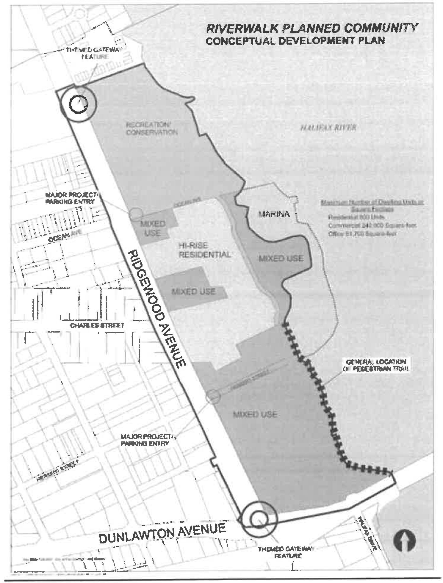
(Ord. No. 2007-11, § 2, 3-20-07; Ord. No. 2010-1, § 1, 2-3-10; Ord. No. 2011-39, § 5, 1-3-12; Ord. No. 2012-27, § 2, 11-13-2012; Ord. No. 2014-13, § 1, 4-22-2014; Ord. No. 2019-5, § 29, 2-5-19; Ord. No. 2021-26, § 3, 10-5-21)
Section 31: - Office/Residential Transition (ORT) district.
(a)
Purpose and intent. The Office/Residential Transition (ORT) district is intended to provide for an appropriate mix of uses along arterial roadways as a means to provide orderly transition from more intense uses at intersection nodes, and is intended to provide a buffer between areas of high- and low-intensity use, especially between low-density residential areas and commercial nodes. It will accommodate a mix of medium-intensity uses, such as general offices, medical and professional uses, retail sales, personal services, multifamily developments, adult care/retirement facilities, and institutional uses. This category is appropriate along arterial and major collector roads, adjacent to commercial nodes, light industrial/heavy commercial areas, and residential areas.
(b)
Mix of uses. The allowable distribution of uses within each ORT unified development will be within the following ranges:
(c)
Permitted uses.
(1)
Principal uses: All uses in this list shall be permitted within the ORT district. Uses are categorized based on similar impacts and to ensure diversity of uses. Those uses with special development requirements are identified with an asterisk (*). These special development requirements are identified in chapter 18, section 4.
(a)
Residential category.
(1)
Multifamily dwelling (ten units per gross acre maximum allowable density).
(2)
Live-work units.*
(3)
Bed and breakfast inn.
(b)
Office/institutional category.
(1)
Assisted living facilities.*
(2)
Business services.
(3)
Child care centers.*
(4)
Financial services.
(5)
Houses of worship.
(6)
Medical office/clinics.
(7)
Nursing homes.*
(8)
Offices.
(9)
Private schools.
(10)
Public park and associated facilities. (This is a supportive use to the principal uses listed. It is allowed by right, but shall not count towards the minimum permitted mix of uses.)
(11)
Veterinary clinics.
(c)
Commercial category.
(1)
Banks.
(2)
Health/exercise clubs *.
(3)
Office supplies.
(4)
Office/warehouse facilities *.
(5)
Personal services
(6)
Restaurants.
(7)
Retail sales and service.
(Ord. No. 2011-29, § 2, 11-8-11)
Section 32: - Mixed Use Center (MXC) district.
(a)
Purpose and intent. The Mixed Use Center (MXC) district is intended to serve as an alternative to the single-use, community-level commercial node in certain settings. A mixed-use center contains a variety of land uses, which may include commercial, office, service, residential, and institutional development, and is focused around a point of high activity, such as an intersection of collectors or higher-classified roads. It is intended to provide a concentration of uses for adjacent neighborhoods and pass-by traffic. The land uses should be mixed, but commercial uses may dominate if necessary to achieve city redevelopment or economic development goals. Such centers may be located along arterial corridors, at intersections with collectors or significant local roads.
(b)
Mix of uses. The allowable distribution of uses within each mixed-use center unified development will be within the following ranges:
(c)
Permitted uses.
(1)
Principal uses: All uses in this list shall be permitted within the MXC district. Uses are categorized based on similar impacts and to ensure diversity of uses. Those uses with special development requirements are identified with an asterisk (*).These special development requirements are identified in Chapter 18, Section 4.
(a)
Commercial category.
(1)
Banks.
(2)
Bars, lounges, and nightclubs *.
(3)
Brewery*.
(4)
Craft food and beverage producer*.
(5)
Game/recreation facility.
(6)
Health/exercise clubs *.
(7)
Marina, recreational *.
(8)
Microbrewery*.
(9)
Office supplies.
(10)
Personal services.
(11)
Restaurants.
(12)
Retail sales and service.
(b)
Office category.
(1)
Business services.
(2)
Financial services.
(3)
Medical office/clinics.
(4)
Offices.
(5)
Public park and associated facilities. (This is a supportive use to the principal uses listed. It is allowed by right, but shall not count towards the minimum permitted mix of uses.)
(6)
Veterinary clinics.
(c)
Residential category.
(1)
Reserved.
(2)
Reserved.
(3)
Reserved.
(4)
Multifamily dwelling (16 units per gross acre maximum allowable density).
(5)
Live-work units *.
(6)
Bed and breakfast inn.
(d)
Institutional category.
(1)
Child care centers *.
(2)
House of worship.
(3)
Private schools.
(Ord. No. 2011-29, § 2, 11-8-11; Ord. No. 2016-19, § 9, 10-4-16)
Section 33: - Recreation (REC) district.
(a)
Purpose and intent. The Recreation (REC) district is intended to provide areas for primarily outdoor recreational uses.
(b)
Permitted uses. Those uses with special development requirements are identified with an asterisk (*).These special development requirements are identified in chapter 18, section 4.
(1)
Archery ranges.
(2)
Boat ramps/launches.
(3)
Gymnasiums.
(4)
Marina, recreational *.
(5)
Outdoor facilities for civic and public functions.
(6)
Outdoor active recreation (public/private) facilities.
(7)
Outdoor passive recreation.
(8)
Sports complexes.
(Ord. No. 2011-29, § 2, 11-8-11; Ord. No. 2019-5, § 30, 2-5-19)