
Ridgefield City Zoning Code
CHAPTER 18
235 - MIXED-USE DISTRICTS CMU, WMU, WLS, LRVP6
Editor's note— Ord. No. 1132, § 2(Exh. A), adopted July 11, 2013, amended Ch. 18.235 in its entirety to read as herein set out. Former Ch. 18.235, §§ 18.235.010—18.235.050, pertained to similar subject matter, and derived from Ord. No. 1108, § 2(Exh. A), 7-26-2012.
18.235.010 - Purpose.
A.
The purpose of the downtown and waterfront mixed-use districts is to encourage multiple uses within the unique areas that make up Ridgefield's central downtown and waterfront areas. The mixed-use districts include the older commercial and residential core of Ridgefield, the waterfront business center and a waterfront residential area that accommodates floating homes. The three districts are tied together by geography, varying proximity to Lake River, transportation links and public infrastructure. Each district has a distinct character and opportunities, to be emphasized through use and design standards tailored to each of the three districts.
B.
The downtown and waterfront mixed-use districts shall allow for a mix of uses in a single building or across an integrated site of multiple buildings, and across the district more broadly. Mixed-use developments are intended to allow for efficient use of land and public services in an urban setting; encourage human interaction and sense of place; create safe, attractive and convenient environments; and increase development flexibility.
C.
Views of the Lake River shoreline and the Ridgefield National Wildlife Refuge are prominent visual features in the central core of Ridgefield. It is the intent of the Lake River View Protection Overlay District (LRVP) to protect these views in order to provide for a unifying feature across the downtown and waterfront mixed-use districts.
D.
The purpose of the Ridgefield Mixed Use Overlay is to encourage development of mixed-use nodes outside the central city in the Pioneer and 45th and Ridgefield Junction subareas. Mixed-use sites are intended to combine commercial, residential and office uses on sites distinguished by high-quality architectural and site design that integrate common open areas, connections between uses and to adjacent sites, and a sensitive response to environmental features.
(Ord. No. 1132, § 2(Exh. A), 7-11-2013; Ord. No. 1219, § 2(Exh. A), 10-27-2016)
18.235.020 - Special provisions for the central mixed use district.
A.
Purpose. The purpose of the central mixed use (CMU) district is to provide for and enhance the traditional commercial and civic core of the community in downtown. The district shall:
1.
Encourage a mix of uses including residential, commercial, office and civic uses. The district shall provide for flexibility in the mix of uses, both within an individual development and across the district.
2.
Accommodate a range of housing types, densities, costs and ownership patterns, with a focus on multifamily and mixed-use residential development including senior housing, in close proximity to employment opportunities and goods and services.
3.
Promote the highest quality architectural design and preserve the character-defining elements of the downtown core area as articulated in the "14 Essential Guidelines for Downtown Ridgefield." Design guidelines shall encourage new development and redevelopment that reflects the scale and materials of existing development.
4.
Create a pedestrian-friendly atmosphere that promotes pedestrian, bicycle and transit access and lessens traffic impacts and dependence on automobile transportation.
5.
Preserve or create open space for the enjoyment of local residents, business employees and the general public, in part through a density transfer program.
6.
Provide a transition to adjacent residential neighborhoods that preserves neighborhood livability, and integration with the adjacent waterfront districts.
B.
Applicability. Full site improvements are required for parking, lighting, landscaping, walkways, storage space, and service areas if a development proposal is:
1.
New development;
2.
Expanding the square footage of an existing structure by twenty percent; or
3.
The construction valuation is fifty percent of the existing site and building valuation.
C.
Uses.
1.
Uses shall comply with the requirements of RDC 18.205.
2.
Mix of Uses. The CMU district allows and encourages a mixture of land uses, both vertically and horizontally, on one parcel or several contiguous combined parcels, but does not require such a mixture of uses on site, provided the development proposal, when considered in relation to surrounding development, achieves the purposes and objectives of this chapter.
a.
The other major use types approved under the site plan (i.e. office or commercial uses) are built prior to the residential portion; or
b.
No single phase may contain more than fifty percent of the total square footage for any one major use type (commercial, office or residential) envisioned by the master site plan unless twenty-five percent of the total square footage of all major use types envisioned by the master plan are included in the proposed phase or were included in previous phases. This requirement may be waived by the director of community planning, if the applicant provides a security or other form of binding assurance that the remaining major use types contemplated in the master plan will be built.
1.
For projects that construct up to fifty percent of the residential component first, frontage improvements for the entire mixed use site shall be required to be constructed concurrently with the residential portion.
c.
No single major use type (residential, commercial, office) shall be more than seventy percent of the total square footage of the mixed use development floor area.
D.
Lot Requirements.
1.
Minimum lot area shall be five thousand square feet.
2.
Minimum lot width shall be fifty feet.
3.
Minimum lot depth shall be ninety feet.
4.
Portions of a horizontal mixed-use development proposal with ground floor residential uses shall comply with the following lot requirements:
a.
Minimum lot area shall be three thousand square feet.
b.
Minimum lot width shall be twenty-five feet.
c.
Minimum lot depth shall be eighty feet.
E.
Dimensional Standards. Additional landscaping buffers may apply that exceed the minimum setbacks listed below; see RDC 18.725.050-1.
_____
Table 18.235.020-1
Table Notes:
(1)
Parking structures, surface parking areas, service areas, gas station islands and similar paved surfaces shall have a minimum five-foot wide setback landscaped to an L2 standard.
(2)
Underground parking may extend into any required setbacks, provided it is landscaped at ground level.
(3)
Maximum setback for new corner buildings shall be zero feet. Maximum setback for all other buildings shall be ten feet.
(4)
Minimum height for new corner buildings shall be thirty feet or at least two stories. Minimum height for all other buildings shall be twenty feet, which can be accomplished through facade treatments such as the false front.
(5)
The Lake River view protection overlay district standards, when applicable, supersede this provision. See RDC 18.235.050.
(6)
Provided setback and site landscaping requirements are met.
(7)
Maximum front yard setback may be increased to fifteen feet for street frontages other than Pioneer or Main Street if topography of the lot requires additional setback to be determined by the planning director.
_____
F.
Density.
1.
Maximum residential density for development in CMU district shall be 16 dwelling units per net developable acre, except as modified by the density transfer or senior housing bonus up to a maximum of 24 dwelling units per net developable acre. Minimum residential density shall be eight dwelling units per net developable acre, if residential uses are included in the development.
2.
Maximum floor area ratio (FAR) for nonresidential development in the CMU district shall be 2.0, except where modified by the density transfer provisions up to a maximum of 3.0. Floor area for residential uses shall not be calculated as part of the FAR for the site and shall be allowed in addition to the FAR limits. Minimum FAR for nonresidential development shall be 0.5.
3.
If a building combines residential and nonresidential uses, residential uses shall occupy a minimum of twenty-five percent to a maximum of seventy percent of the gross floor area of the building. The minimum and maximum standards in 18.235.020.E.1 and 2 for residential density and FAR shall be met. Residential uses shall not occupy the ground floor of buildings with frontage on Pioneer Street or Main Avenue.
G.
Street Frontage.
1.
At least fifty percent of a street frontage not encumbered by protected critical areas shall be occupied by buildings.
2.
At least one main entrance of a building shall face directly toward the street. Entrances shall be made physically and visually inviting by means of incorporating a minimum of two of the following entry enhancement features:
i.
Additional landscaping equal to ten percent of required site landscaping;
ii.
At least two hundred square feet of paving materials different from the street sidewalk;
iii.
At least one hundred square feet of awning, marquee, or arcade over the entry;
iv.
At least two hundred square feet of pedestrian plaza with landscaping and benches that is attached to the entry;
v.
Entry recessed from the facade surface by at least three feet; or
vi.
Accent lighting.
H.
Building Design and Features.
1.
Applicability. The requirements of Section 18.235.020.H apply to:
a.
New buildings of any size,
b.
The addition to or remodel of an existing building that increases the square footage of the building by twenty percent, and
c.
The addition to or remodel of an existing building where the construction valuation is fifty percent or greater of the existing site and building valuation.
2.
Building design shall reinforce the building's location adjacent to street edge and public space.
3.
Building design should emphasize high quality design that implements the provisions contained in the city of Ridgefield's "14 Essential Guidelines for Downtown Ridgefield" document, including but not limited to:
i.
Use of colors and architectural details in building design.
ii.
Articulation of base, body and cornice in building design.
iii.
Use of stone, brick, stucco and wood as primary materials.
4.
New buildings must build a floor to ceiling height of at least twelve feet on the ground floor, and be fire-rated construction to accommodate retail or restaurants.
5.
Fenestration.
i.
Where the lot abuts Main Avenue or Pioneer Street, new buildings must have a minimum of fifty percent of the first floor facing the street treated with transparent windows or doors.
ii.
Where the lot abuts Main Avenue or Pioneer Street, new buildings must have a minimum of twenty-five percent of the upper stories facing the street treated with transparent windows.
iii.
Where the lot abuts Main Avenue or Pioneer Street, buildings not subject to subsections (i) and (ii) must maintain the existing percentage of the first floor facing the street treated with transparent windows or doors, or treat a minimum of twenty-five percent of the first floor facing the street with transparent windows or doors, whichever is greater.
iv.
New alley-facing facades must have a minimum of twenty-five percent of the first floor treated with transparent windows or doors.
6.
Any portion of the first floor facade facing Main Avenue or Pioneer Street without windows or doors that is at least thirty feet in length shall be articulated in one or more of the following ways:
i.
Incorporating relief through such features as wall projections or recesses, projecting windows, entrances, or other visual relief.
ii.
Installing a vertical trellis in front of the facade with climbing vines or planting materials.
iii.
Awning, marquee or arcade at least four feet and six inches deep, over the full length of sidewalk or walkway adjacent to the building, and minimum eight feet above the walkway level.
iv.
Providing texture or artwork (mosaic, mural, sculpture, relief, etc.) over the facade surface.
v.
Other equivalent methods that provide for the enhancement of the facade, as determined by the planning director.
7.
New buildings located at an intersection where at least one leg of the intersection is Main Avenue or Pioneer Street shall accentuate the building corner facing the intersection by including architectural treatment that emphasizes the corner, such as: balconies, turret, corner accentuating roof line, sculpture, chamfered corners, distinctive use of materials, canopy, and bay window.
8.
The following accessory structures shall be screened by a fence or landscaping to a value of eighty percent year-round opacity from public view along Main Avenue or Pioneer Street:
i.
All on-site service areas, loading zones, outdoor storage areas, garbage collection, recycling areas, and similar activities. Design of exterior storage areas shall comply with engineering standards and the comprehensive stormwater management plan (CSMP), including roof cover, paving, and runoff containment, to prevent nonstormwater discharges from entering the stormwater drainage system.
ii.
Utility vaults, ground-mounted mechanical units, trash receptacles and other similar structures.
iii.
Satellite dishes or pedestrian-oriented waste receptacles along walkways are not required to comply with this standard.
9.
Mechanical units, utility equipment, elevator equipment, and telecommunication equipment located on the roof shall be grouped together, incorporated into the roof design, and/or screened from adjacent walkways to a value of eighty percent year-round opacity.
10.
Security bars on windows, roll-up security doors, and similar treatments are prohibited.
I.
Signs. Signs are permitted according to the provisions of Chapter 18.710.
J.
Lighting. Lighting shall comply with the provisions of Chapter 18.715. In addition, lighting shall comply with the following standards:
1.
All building entrances and storefronts shall be illuminated.
2.
Lighting fixtures should complement the design of the project in reference to the character, style and scale of the project.
3.
Parking area light post height shall not exceed twenty-five feet.
K.
Parking.
1.
Off-street parking and loading shall be provided as required in RDC Chapter 18.720.
2.
Parking areas shall be located so as to minimize their visual impact. Parking shall be placed at the side or rear of buildings, to encourage pedestrian, transit and bicycle access. Parking shall not be located between the front of a building and the street except as a nonconforming use pursuant to Chapter 18.340. On corner lots where one leg of the intersection is an arterial, minor arterial, or collector street, the parking area shall be no closer than the lesser of one hundred feet or twenty-five percent of the street frontage, measured horizontally along the frontage, from the intersecting rights-of-way of the arterial, minor arterial, or collector street with another street.
L.
Landscaping.
1.
Landscaping shall meet the requirements of RDC 18.725.
2.
There is no minimum percentage of required landscaping in the CMU district, provided setbacks and buffers are provided as required by RDC 18.725.050.
M.
Fences.
1.
Fences shall comply with the provisions of RDC 18.740.
2.
Fences designed for privacy, security and/or screening shall be:
i.
Made of material that is compatible with the building design, such as repetition of the building material on fence columns and/or stringers.
ii.
Used only in combination with trellis, landscaping, or other design alternatives to separate such fence from the pedestrian environment along Main Avenue or Pioneer Street.
N.
Outdoor Uses.
1.
Outdoor storage or display areas, excluding outdoor seating or event areas, shall occupy an area no larger than ten percent of gross floor area except for plant sales that shall occupy no more than seventy-five percent of gross floor area.
2.
Permanent outdoor seating and event areas, cumulatively, are limited to twenty percent of the gross site area. The planning director may issue a temporary use permit for the use of up to thirty percent of the gross site area for temporary outdoor seating and event space consistent with RDC 18.205.015.F. The city council, in a public meeting, may authorize a temporary use permit for temporary outdoor seating and event space that uses more than thirty percent of the gross site area.
3.
Outdoor uses in the public right-of-way are prohibited unless the city expressly authorizes the temporary use of the right-of-way, e.g., for sidewalk sales or other special events.
O.
Open Space Density Transfer.
1.
Purpose. The purpose of density transfer regulations is to provide an incentive to property owners for encouraging the provision of open space, while maintaining the overall density of the CMU district.
2.
Applicability.
i.
All land within the CMU district is eligible for designation as open space for the purpose of density transfer under this subsection.
ii.
Trails through land designated for other use, or isolated open areas such as pedestrian plazas fully integrated in other use areas, shall not qualify for transfer of density.
iii.
Density may be transferred to any parcel within the CMU district provided resulting development meets all other provisions of the CMU district contained in this section.
3.
Transfer Rates. Transfer of density from land planned for open space shall be at a rate of either eight dwelling units per net developable acre or an FAR of 1.0, as elected by the applicant. Dwelling units or FAR to be transferred shall be calculated based on the net developable acreage of the open space lot. The number of bonus dwelling units shall be determined by rounding fractional numbers to the nearest whole number and rounding up to the nearest whole number from 0.5.
4.
Lots qualifying to receive a transfer of density must be a minimum of five thousand square feet.
5.
The application of this subchapter shall not result in the creation of a single open space lot with a gross area that is less than eighty percent of the minimum lot size in the CMU district, nor shall any lot dimension (width, depth) be created that is less than eighty percent of the minimum required dimension.
6.
The property owner shall provide a guarantee that the land qualifying for such transfer shall be protected as open space. Such guarantees may include, but are not limited to: conservation covenants or easements; mitigation plans; designation of open space areas to be held in common ownership; public dedications or easements; and, special setbacks from protected resources.
7.
Should the city not accept dedication of the property, the property owner and city council shall enter into a development agreement which shall establish the requirements and standards for the upkeep and maintenance of the property, in perpetuity, and the property owner shall record a covenant that runs with the land requiring that the owner of the property shall maintain the property in accordance with the requirements and standards of the development agreement, in perpetuity.
8.
Process. The property owner may apply for open space density transfer concurrent with other applications for the same parcel(s). Applications shall be processed as a Type II request or higher, depending on the level of review for concurrent applications.
i.
The application must include a site plan delineating the boundaries of the proposed open space parcel(s) and receiving parcel(s).
ii.
The application must include calculations of the area in square feet of each lot proposed, and resulting density.
P.
Senior Housing Bonus.
1.
Purpose. The purpose of the senior housing bonus is to encourage the construction of housing which is accessible and affordable to seniors of Ridgefield.
2.
Applicability. The senior housing bonus may be used for any multifamily or mixed-use development in the CMU zone. The bonus shall be part of any subdivision, PUD, binding site plan, or site plan application. If the bonus is approved, the use shall comply with the requirements for this section for the life of the use.
3.
Requirements.
i.
Senior Housing Restrictions.
a.
Age Restriction. The development shall be restricted to persons fifty-five years of age or older and handicapped persons as defined by federal law. At least half of the total housing units shall be occupied by persons fifty-five years of age or older, except for spouses of such residents for whom there is no minimum age requirement.
b.
Conversion From Occupancy by Seniors. No conversion of occupancy to persons other than those specified by subsection (a) shall be allowed without first complying with the underlying zoning and site requirements. The bonus shall not apply to the property if it is no longer occupied by those persons specified by subsection (a), and the bonus housing units shall be eliminated unless otherwise authorized by the applicable development regulations.
ii.
Density Bonus. If a senior housing bonus application is approved, developments may exceed the allowed density of the CMU zone by as much as fifty percent, up to a maximum of twenty-four dwelling units per net developable acre.
a.
The number of bonus units shall be determined by rounding fractional numbers to the nearest whole number and rounding up to the nearest whole number from 0.5.
b.
An agreement in a form approved by the city shall be recorded as a covenant or other legally binding limitation on the use and intensity of the property requiring compliance with the requirements of this section and requiring that the age restrictions on housing units created under this section shall be upheld for the life of the project. This covenant or other legally binding limitation on the use and intensity of the property shall run with the land, shall be binding on the assigns, heirs and successors of the applicant, and shall be recorded in Clark County's real property records before the use is occupied.
iii.
Application For and Use of the Density Bonus. The density bonus shall only be used in the multifamily or mixed-use development for which it is approved. The bonus application shall be made as part of the first discretionary application made for the project. The decision maker for this application shall decide the request for the bonus.
iv.
Site Requirements. All site requirements and development standards of the CMU district shall apply to uses that obtain a senior housing bonus. Additionally, developments shall be designed to project a residential appearance through architectural design, landscaping, the use of building materials, and surface lengths.
(Ord. No. 1132, § 2(Exh. A), 7-11-2013; Ord. No. 1178, § 2(Exh. A), 2-12-2015; Ord. No. 1253, § 2(Exh. A), 12-7-2017; Ord. No. 1260, § 2(Exh. A), 4-26-2018; Ord. No. 1296, § 2(Exh. A), 10-10-2019; Ord. No. 1406, § 2(Exh. A), 7-13-2023; Ord. No. 1460, § 2(Att.), 11-6-2025)
18.235.025 - Special provisions for the Downtown Arts Quarter.
A.
Purpose. The purpose of the Downtown Arts Quarter is to establish a City supported program to enhance Ridgefield's core by providing opportunities for visible public art and unique development design features that reflect the character of the city and build the sense of community. The district is intended to accomplish the following:
1.
Accommodate public art that reflects Ridgefield's history, culture, natural environment, and downtown vitality.
2.
Encourage art installations designed by local artists using high-quality materials.
3.
Support collaboration between the city, the Ridgefield Art Association, downtown businesses, and local artists to determine the nature and location of new public art.
4.
Activate public space in downtown Ridgefield for the enjoyment of residents and visitors to promote civic involvement and economic development.
5.
As used in this section, public art means artwork that is visible and can be engaged with by the public.
B.
Applicability. The provisions of this section apply to the portions of the Central Mixed Use (CMU) District shown in Figure 18.235.025-1.
Figure 18.235.025-1 Downtown Arts Quarter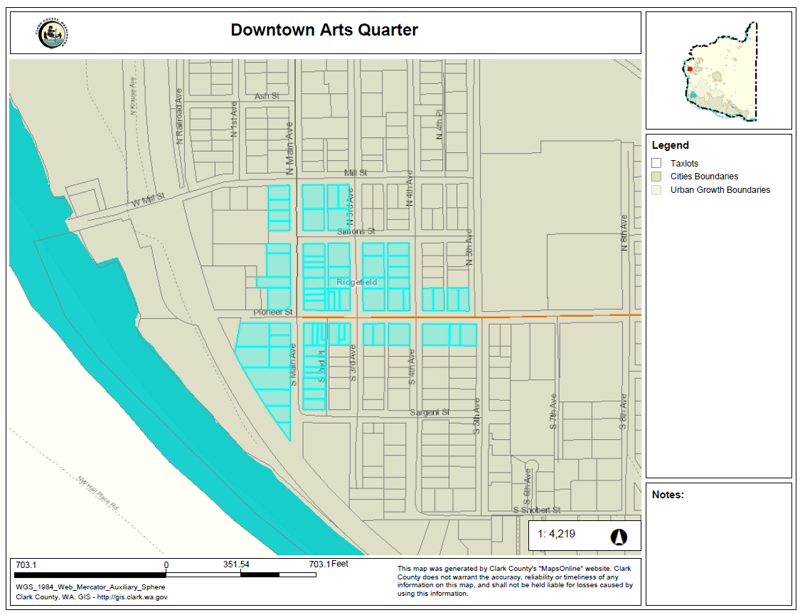
C.
Design Features.
1.
The city encourages art and development design features reflecting and promoting the city's history, culture, natural environment, and downtown vitality to be incorporated into public and private development within the Downtown Arts Quarter. Examples of encouraged art include
a.
Murals. Murals on buildings throughout the Downtown Arts Quarter, visible to pedestrians, cyclists, and drivers on streets and alleys.
b.
Sculptures. Sculptures installed in visible locations along the Pioneer Street corridor within the Downtown Arts Quarter.
c.
Active alleys. Art, including murals and overhead installations, that activates alleys for public use and enjoyment.
d.
Street furnishings. Public benches, trash receptacles, and planters that comply with the street furnishing preferences expressed in the 2013 Main Avenue Streetscape Committee Recommendations, in particular benches that incorporate natural materials and motifs.
e.
Street signs. Street signs mounted on decorative poles, with additional Downtown Arts Quarter designation signs.
2.
In order to be eligible for city support the public art must meet the following standards:
a.
Located within city right of way or visible from publicly-owned property within the Downtown Arts Quarter.
b.
Appropriate in size, scale, and form for the site in which it is to be placed.
c.
Composed of high-quality durable materials that are easy to maintain
d.
Must reflect and promote Ridgefield's history, culture, natural environment or downtown vitality.
e.
Recommended for approval by the Ridgefield Art Association to the city council.
D.
Support. Art installations that comply with the goals and standards in RDC 18.235.025.A-C may be eligible to receive city funding, promotion, and/or ongoing maintenance, pursuant to the applicant entering into an agreement with the city.
E.
Submittal Requirements. in order for a proposed public art installation to be considered for city support, the applicant shall submit to the community development director:
1.
One hard copy and one electronic copy (if feasible) of a to-scale depiction of the proposed art installation. This submittal shall include, as appropriate:
a.
A three-dimensional model or complete drawing of a two-dimensional installation
b.
Drawings or photographs that demonstrate the relationship of the artwork to the site
c.
Material samples for the artwork and any relevant construction materials
d.
Installation details
e.
Location of installation
f.
Maintenance requirements if applicable
g.
For installation on public property, additional permits or submittals may be required.
2.
One hard copy and one electronic copy of a written narrative describing how the proposed installation meets the objectives in RDC 18.235.025.A and the design features in RDC 18.235.025.C. The narrative should also specify the nature of the requested city support.
3.
One copy of the artist's portfolio.
F.
Approval Process.
1.
The community development director shall review the application materials for compliance with the goals and standards of RDC 18.235.025 and submit a staff recommendation to the Ridgefield Art Association.
a.
For art installations proposed on public property, the staff recommendation shall include a review by the public works director for compliance with all applicable ordinances or statutes and any maintenance or public safety concerns.
2.
The Ridgefield Art Association will review the materials and submit a recommendation to city council. Staff will prepare a written agreement setting forth the terms of the recommendation for consideration by the city council.
3.
City council may approve or deny the agreement and request for city support for public art within the Downtown Arts Quarter.
4.
Any award of support is conditioned on the city and applicant entering into the approved agreement.
5.
Street furnishings and street signs in the Downtown Arts Quarter shall be approved by the public works director prior to installation.
G.
Prohibitions.
1.
Installations that exhibit one or more characteristics of prohibited signs per RDC 18.710.040, prohibited signs.
2.
Installations that are not compliant with any other provisions of the Ridgefield Municipal Code.
(Ord. No. 1263, § 2(Exh. A), 5-24-2018)
18.235.030 - Special provisions for the waterfront mixed use (WMU) district.
A.
Purpose. The purpose of the WMU district is to encourage multiple uses while providing an environment for public access to and enjoyment of the waterfront. The WMU district shall accommodate both employers and visitors. The district encourages development that will establish a waterfront where people can be productive, work, and create value while also serving as a destination that caters to those who want to visit, recreate, relax, and shop. The goal of this zone is to implement the Ridgefield Urban Area Comprehensive Plan (RUACP) revitalize the waterfront as a publicly accessible shoreline for community gathering and recreation.
B.
Function of the WMU District.
1.
Provide Responsible Economic Reuse of a Brownfield Site. Redevelopment within this district will create jobs, provide shopping and housing opportunities, and offer education on the environmental history and stewardship of the area.
2.
Provide Public Access to the Water. This district is the nearest public waterfront and access to the Columbia River for the community of North Clark County, and therefore, access to the water is an essential element of this district.
3.
Transition to the Wildlife Refuge. The proximity and relationship the WMU district has with the National Wildlife Refuge is unique. Development in the district should embrace this bond by incorporating connectivity to the environment, the active community, and vibrant ecology. Design guidelines for this district shall be conscious of the transition to the wildlife refuge and shall minimize impacts to wildlife by utilizing construction techniques and building materials likely to reduce impacts to the bird population.
4.
Relationship to Downtown. Integration of the WMU district with the downtown mixed use district is a key element for successful redevelopment of the waterfront. Both the CMU and WMU districts will benefit from well-planned adjacent districts that accommodate a variety of users and business opportunities.
C.
Uses.
1.
Uses. Uses shall comply with the requirements of RDC 18.205 and 18.235.030.C.
2.
Review Procedures. For any uses proposed in the WMU district, the proposal shall demonstrate compliance with:
i.
Concurrency and level-of-service standards of the city's capital facilities plan;
ii.
Adopted engineering standards;
iii.
An approved master planned subdivision; and
iv.
Any development agreement applicable to property within this district.
3.
Primary and Accessory Uses. The planning director shall distinguish between primary and accessory uses as follows:
i.
Primary uses are uses which are listed as permitted or limited uses in Table 18.205.020-1 and Table 18.235.030-1.
ii.
Accessory uses have the following characteristics:
a.
Occupy less gross floor area than the permitted use(s);
b.
Do not occupy the majority of storefront area visible from the primary entrance;
c.
Signage is less than provided for the primary use(s);
d.
Do not have significant adverse impacts on the city, the environment, or the surrounding neighborhood which cannot be adequately mitigated through compliance with the RDC;
e.
Are listed as a permitted or limited use in Table 18.205.020-1 or Table 18.235.030-1 or are accessory to a permitted or limited use as defined in RDC 18.100.280.A.
4.
The uses in Table 18.235.030-1 are intended to provide for specific uses appropriate for the waterfront in the WMU. These uses supplement the uses listed in Table 18.205.020-1. Together these uses are intended to encourage a mix of uses in the WMU.
i.
Permitted Uses. Permitted uses are listed in Table 18.235.030-1 with a "P". These uses are allowed, subject to site plan review if required per RDC 18.500, if they comply with the development standards and other regulations contained in the RDC.
ii.
Limited Uses. Allowed uses with additional limitations are listed in Table 18.235.030-1 with an "L". If the property proposed for development is owned by the Port of Ridgefield, limited uses are allowed if they comply with the limitations listed in the footnotes to Table 18.235.030-1, as determined by the planning director through a Type I review, and the development standards and other regulations contained in the RDC. Limited uses in Table 18.235.030-1 are subject to site plan review as governed by RDC 18.500. Limited uses shall not be approved unless the application includes a resolution made by the Port of Ridgefield Commissioners that the proposed use was anticipated in the master plan approved by the city.
iii.
Prohibited Uses. Uses listed in Table 18.235.030-1 with an "N" are specifically prohibited.
iv.
Notes. A (#) references specific review/approval criteria as noted.
_____
Table 18.235.030-1
Table Notes:
(1)
Private docks and boathouses will be approved subject to the special provisions in Section 18.235.030.E.
(2)
Floating restaurants will be approved subject to the special provisions in Section 18.235.030.E.
(3)
Outdoor storage shall be allowed secondary to primary uses if it is screened according to the provisions of Section 18.725, and does not cover more than ten percent of the gross site area of the primary lot of parcel where the primary use is located. Outdoor storage not directly associated with a primary use, such as storage of boats, trailers, building materials, equipment or similar objects, shall only be permitted to the extent expressly allowed in a development agreement adopted by the Port of Ridgefield and the city of Ridgefield.
(4)
Consistent with the purpose of the WMU zoning district, warehousing is a prohibited use in the WMU zone unless the Ridgefield City Council and the Port of Ridgefield adopt a development agreement which expressly allows warehousing and which delineates the scope and intensity of warehousing allowed.
5.
Similar Use. In addition to uses listed in Table 18.235.030-1, the planning director shall determine whether a use not clearly identified in Table 18.235.030-1 as "Permitted," "Limited," or "Prohibited" is sufficiently similar to uses identified in Table 18.235.030-1, or an approved master plan, and if similar to a permitted or limited use or use approved in the master plan, the use is allowed subject to all other provisions of this chapter. This determination will be made through a Type I process. Submittal requirements for a Type I use determination review require a detailed description of the use, applicable fee, a resolution made by the Port of Ridgefield Commissioners that the proposed use was anticipated in the master plan approved by the city, a completed Type I application form, and additional supporting materials the planning director deems essential to the review. The planning director shall complete the review under the Type I application process pursuant to RDC 18.310.060. Appeals of the planning director's determination shall be allowed pursuant to RDC 18.310.100.
D.
Site Requirements. Additional landscaping buffers may apply that exceed the minimum setbacks listed below; see RDC 18.725.050-1.
Table 18.235.030-2
Table Notes:
(1)
Minimum width does not apply to the flag portion of a flag lot which shall be a minimum of fifteen feet wide.
(2)
Minimum landscaped area can be consolidated to include additional lots when approved through a master plan and/or development agreement.
(3)
Maximum impervious area can be consolidated to include additional lots when approved through a master plan and/or development agreement.
(4)
Rooftop mechanical units are excluded from maximum height requirements when screening is supplied for the mechanical unit. To be exempt from height limitations, screening provided which is the same height as the mechanical unit, constructed of materials consistent with the architectural features of the structure including roof elements, and measuring no more than thirty percent of the building length from north to south is permitted. Architectural features, including but not limited to, parapets, roof elements, mechanical screening improvements, and aesthetic architectural features are also excluded from maximum height regulations.
_____
E.
Special Provisions.
1.
Public Access to the Waterfront. All lots abutting a shoreline must provide reasonable public access to the shoreline for Lake River. Reasonable public access can be provided through vehicular and/or pedestrian access in public city rights-of-way or other private public easements.
2.
Parking Lots. Parking lots shall not be located closer to the shoreline than occupied buildings. Existing parking associated with uses existing on the date this district is established shall be permitted to continue but no expansion will be allowed.
3.
Nonconforming Uses. In recognition of the time needed to attract uses within the WMU district, the period of discontinuance of nonconforming use pursuant to Section 18.340.040.A.5. shall be two years.
4.
Relocation of Existing Uses. In recognition of the need to relocate structures and uses within the WMU district to accommodate on-going environmental remediation of property within the district, the businesses lawfully operating within the district on the date the district is established may be relocated, moved, or reconstructed within the district and will continue to be considered as permitted uses.
5.
View Corridors. Views of the waterfront and of the adjacent National Wildlife Refuge are an important amenity to the waterfront development and the adjacent residential and commercial downtown districts. To protect these views, and provide for waterfront development as planned, view corridors shall be provided as follows: no structures with a height of more than twenty-five feet shall be located within view corridors established within the westerly projections of Depot, 9th, Cook, Hall, Elm, Maple, Division, and Mill Streets to the mean low water line of Lake River, and are measured thirty feet from each side of the centerline of these streets. The city may permit exceptions to the view corridors to allow obstruction of up to two of these corridors or may modify the restrictions on height and width standards through a Type II process, when accompanied by a resolution adopted by the Port of Ridgefield Port Commission at a public meeting.
6.
View Sheds. View sheds have been established in order to preserve maximum views of the National Wildlife Refuge from downtown, the adjacent hillside south of Ash Street, and residential areas north of Cook Street. To protect these views, no structures with a height of more than forty-five feet shall be located south of the westerly projection of the centerline of Ash Street or north of the westerly projection of the centerline of Cook Street. Exceptions allowable to height limitation in Table 18.235.030-2 (site requirements) are permitted in the view shed protection area.
7.
Private Docks. Private docks, or limited access docks, are generally inconsistent with the goals of the WMU district. However, in limited cases where public access is incompatible with a proposed use, a private or limited access dock may be permissible. In the site plan review process, the applicant must first demonstrate why public access is not desirable for the dock. Appropriate reasons may include public safety concerns with access to the dock, possible interference with a critical function of the dock if public access were permitted, the need for additional privacy to protect research or trade secrets, or the need for emergency services security. In these limited cases, the city may consider the needs for the private dock in comparison to the goals of the WMU district zone and any applicable master plan. The city may permit private docks only when the request is accompanied by a resolution adopted by the Port of Ridgefield Port Commission at a public meeting.
8.
Floating Retail or Restaurants. The waterfront is a limited resource and water-dependent uses must be given priority along the water and adjacent shoreline. Floating retail and restaurants are generally consistent with the purpose of the WMU district if limited according to the provisions of this section. Floating retail uses are limited to retail uses which cater to the boating or water recreating public. Floating restaurant uses are permitted if they promote public access and enjoyment of the waterfront and if they are designed to increase public enjoyment and access. Floating restaurant uses are also permitted when the design does not obstruct public use of walkways or marina facilities. The city may permit floating retail or restaurants only when the request is accompanied by a resolution adopted by the Port of Ridgefield Port Commission at a public meeting.
9.
Building Orientation. Buildings should be oriented with the front of the building facing the internal circulation corridor. Buildings should generally be oriented along an east-west axis when located between the internal circulation and Lake River. Buildings between the internal circulation and the railroad tracks can be oriented along a north-south or east-west axis. Buildings within two hundred feet of the Lake River shoreline must include an entrance and storefront display on the west side of the building.
F.
Landscaping. Landscaping shall be provided as required in Section 18.230.070 to provide a minimum of fifteen percent landscaped area. Landscaping shall meet all requirements detailed in RDC 18.725.
G.
Parking and Loading. Off-street parking and loading shall be provided as required in Chapter 18.720. Parking garages are exempt from parking lot landscaping standards and dimensional standards for surface parking lots. Parking dimensions and drive aisles shall be designed to promote efficient use of parking areas and provide adequate passenger car maneuverability.
H.
Signage. Signs are permitted according to the provisions of Chapter 18.710.
(Ord. No. 1132, § 2(Exh. A), 7-11-2013; Ord. No. 1253, § 2(Exh. A), 12-7-2017)
18.235.040 - Special provisions for the waterfront low scale (WLS) district.
A.
Purpose.
1.
The waterfront low scale (WLS) district encompasses the area bounded by Railroad Avenue, Mill Street and Lake River.
2.
The WLS district is intended to implement provisions of the Ridgefield Urban Area Comprehensive Plan for well designed, mixed-use development along the Lake River waterfront. The purpose of the district is to preserve and enhance the natural resources base of the area and to connect the city to its waterfront. The district shall provide for a mix of uses including existing waterfront housing, primarily floating homes; visual access to the waterfront; and commercial uses. The district shall provide for primarily water-oriented uses within the shorelines of the city that meet the provisions of the city's adopted Shoreline Master Program (SMP).
B.
Shorelines Restrictions.
1.
The city may approve developments within the city's shorelines only after the applicant meets the provisions contained in the city's adopted Shoreline Master Program. Applicants are required to obtain any required shorelines permits in addition to land use permits required by this Title. See Chapter 18.820, Shoreline Management.
2.
Applicability. If the provisions of the SMP conflict with other applicable local ordinances, policies and regulations, including this section, the more restrictive shall apply.
C.
Uses.
1.
Uses shall comply with the provisions of RDC 18.205.
2.
Uses in Over-Water Structures. Uses in over-water structures must comply with all use regulations applying to the upland lot that the floating structures are attached to. In addition, uses in over-water structures must comply with the adopted SMP and the Ridgefield Building Code for over-water structures.
D.
Lot Requirements.
1.
There shall be no minimum or maximum lot size for development in the WLS district.
2.
The minimum lot width shall be fifty feet.
E.
Threshold for Design and Site Improvements. Conformance with RDC 18.235.040.F—J is required if a development proposal is:
1.
New development;
2.
Expansion of the gross floor area of an existing structure by twenty percent; or
3.
Construction valued at fifty percent of the existing site and building valuation.
F.
Dimensional Standards. Additional landscaping buffers may apply that exceed the minimum setbacks listed below; see RDC 18.725.050-1.
Table 18.235.040-1
Table Notes:
(1)
Front yard setback for residential developments (excluding mixed-use developments), parking structures, surface parking areas, service areas, gas station islands, and similar paved surfaces shall be a minimum of ten feet wide measured from the back of the sidewalk, and be fully landscaped to an L2 standard.
(2)
For over-water structures, requirements apply to upland lot only.
G.
Design Standards.
1.
Applicability. The requirements of Section 18.235.040.G apply to:
a.
New buildings of any size,
b.
The addition to or remodel of an existing building that increases the square footage of the building by twenty percent, and
c.
The addition to or remodel of an existing building where the construction valuation is fifty percent or greater of the existing site and building valuation.
2.
Building design shall reinforce the building's location adjacent to street edge and public space. Building design shall also reinforce the connection with the Lake River waterfront.
3.
Where the lot abuts Mill Street, at least fifty percent of the lot's street frontage not encumbered by protected critical areas shall be occupied by buildings
4.
Where the lot abuts Mill Street, at least one main entrance of a building shall face directly toward the street. Entrances shall be made physically and visually inviting by means of incorporating a minimum of two of the following entry enhancement features attached to the entry:
i.
Additional landscaping equal to ten percent of required site landscaping;
ii.
At least two hundred square feet of paving materials different from the street sidewalk;
iii.
At least one hundred square feet of awning, marquee, or arcade over the entry;
iv.
At least five hundred square feet of pedestrian plaza with landscaping and benches that is attached to the entry;
v.
Entry recessed from the facade surface by at least three feet; or
vi.
Accent lighting.
5.
Where the lot abuts Mill Street, nonresidential buildings must have a minimum of fifty percent of the first floor facing the street treated with transparent windows or doors. Any portion of the first floor facade without windows or doors that is at least thirty feet in length shall be articulated in one or more of the following ways:
i.
Incorporating relief through such features as wall projections or recesses, projecting windows, entrances, or other visual relief.
ii.
Installing a vertical trellis in front of the facade with climbing vines or planting materials.
iii.
Providing texture or artwork (mosaic, mural, sculpture, relief, etc.) over the facade surface.
iv.
Other equivalent methods that provide for the enhancement of the facade, as determined by the planning director.
6.
The following accessory structures shall be screened by a fence or landscaping to a value of eighty percent year-round opacity from public view along Mill Street:
i.
All on-site service areas, loading zones, outdoor storage areas, garbage collection, recycling areas, and similar activities. Design of exterior storage areas shall comply with engineering standards and the comprehensive stormwater management plan (CSMP), including roof cover, paving, and runoff containment, to prevent nonstormwater discharges from entering the stormwater drainage system.
ii.
Utility vaults, ground-mounted mechanical units, trash receptacles and other similar structures.
iii.
Satellite dishes or pedestrian-oriented waste receptacles along walkways are not required to comply with this standard.
7.
Mechanical units, utility equipment, elevator equipment, and telecommunication equipment located on the roof shall be grouped together, incorporated into the roof design, and/or screened from adjacent walkways.
H.
Signs.
1.
Signs are permitted according to the provisions of Chapter 18.710.
I.
Lighting.
1.
Lighting shall comply with the provisions of Chapter 18.715.
J.
Parking.
1.
Off-street parking and loading shall be provided as required in RDC Chapter 18.720 in addition to the following standards.
2.
Parking visible from Mill Street shall be screened to eighty percent year-round level of opacity.
3.
Parking lots shall be located so as to minimize their visual impact. Parking shall be placed at the side or rear of buildings, to encourage pedestrian, bus and bicycle access.
4.
For development within the shorelines of the city, parking shall be located landward of the primary structure as far as possible or within the primary structure where parking is allowed as accessory to a permitted use.
5.
Floating home moorages must provide a minimum of one and one-half parking spaces and a maximum of two parking spaces per floating home. The parking is to be provided on the upland lot to which the floating home moorage is attached.
K.
Landscaping.
1.
Landscaping shall comply with the provisions of RDC 18.725.
2.
A minimum of fifteen percent landscaped area shall be required for development in the WLS zoning district.
L.
Fences.
1.
Fences shall meet the requirements of RDC 18.740.
2.
Fences designed for privacy, security and/or screening shall be:
i.
Made of material that is compatible with the building design, such as repetition of the building material on fence columns and/or stringers.
ii.
Used only in combination with trellis, landscaping, or other design alternatives to separate such fence from the pedestrian environment along Mill Street.
M.
View Corridors.
1.
Views of the waterfront and of the adjacent National Wildlife Refuge are an important amenity to the waterfront development and the adjacent residential and commercial downtown districts. To protect these views view corridors shall be provided as follows: no structures with a height of more than twenty-five feet shall be located within view corridors established within the westerly projections of Mill, Simons, Pioneer, and Sargent Streets to the mean low water line of Lake River, and are measured thirty feet from each side of the centerline of these streets. The city may permit exceptions to the view corridors to allow obstruction of up to one of these corridors or may modify the restrictions on height and width standards through a Type III process.
(Ord. No. 1132, § 2(Exh. A), 7-11-2013; Ord. No. 1253, § 2(Exh. A), 12-7-2017; Ord. No. 1296, § 2(Exh. A), 10-10-2019; Ord. No. 1406, § 2(Exh. A), 7-13-2023)
18.235.050 - Special provisions for the Lake River view protection overlay district.
A.
Purpose.
1.
The Lake River shoreline and the Ridgefield National Wildlife Refuge are prominent landmarks in the central core of Ridgefield. Views of these areas produce a variety of significant and tangible benefits for both residents and visitors to Ridgefield. Views contribute to the economic environment of the city by substantially enhancing property values. Views contribute to the visual environment of the city by providing inspiring panoramic vistas, and creating distinctive supplements to architectural design. Views contribute to the cultural environment of the city by providing a unifying effect, allowing individuals to relate different areas of the city to each other in space and time.
2.
To maintain and enhance the beneficial effects of the Lake River shoreline and Ridgefield National Wildlife Refuge views from the central core, the city shall create an overlay district that limits the heights of buildings and structures that may impede such views.
3.
The goals of this overlay are to provide visual access along the westerly projections of the public right-of-ways west of Main Avenue and to encourage the preservation of upper story view sheds westward from Main Avenue over individual lots.
4.
To achieve these purposes the height of buildings shall stair step down the hill from Main Avenue to the western edge of the district. In addition, building and structure orientation should both enhance view shed opportunities from the building and should minimize obstruction of view sheds from adjacent buildings and structures.
B.
District. The Lake River view protection overlay district shall extend from the centerline of Sargent Street to the centerline of Mill Street and from the centerline of Main Avenue to the eastern edge of the main line of the BNSF railroad tracks.
1.
View corridors within the overlay district include Sargent, Pioneer, Simons and Mill, streets west of Main Street.
2.
View sheds include views of the Lake River shoreline and the Ridgefield National Wildlife Refuge over private property from Main Avenue westward.
3.
Within the overlay district:
i.
The elevation differential between the centerline of Main Avenue and the centerline of First Avenue, as extended north to south through the district, ranges between six to twelve feet;
ii.
The elevation differential between the centerline of First Avenue and the centerline of Railroad Avenue, as extended north to south through the district, ranges between twenty to thirty-two [feet]; and
iii.
The overall elevation differential between the centerline of Main Avenue and Railroad Avenue, as extended north to south through the district, ranges between twenty-six to forty-four feet.
C.
Applicability. If a structure, lot, or other parcel of land lies partly within the overlay district, that part of the structure, lot, or parcel shall meet all the requirements for this district as set forth in this subsection.
D.
Relationship to Underlying Zoning. With the exception of the maximum building or structure height requirement, all other requirements of the underlying zoning district shall apply to development within this district.
E.
Maximum Building and Structure Height Limits. Maximum building and structure heights shall conform with Figure 18.235.050-1. The height of buildings shall stair step down from east to west in order to preserve the upper story views from upslope buildings. Property owners are encouraged to maximize viewing opportunities from western-facing facades.
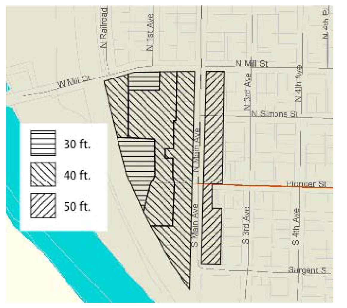
Figure 18.235.050-1
F.
Exemptions.
1.
Development in the CMU district that qualifies for a senior housing bonus as detailed in RDC 18.235.020.N shall be exempt from the maximum building and structure height limits listed in 18.235.050.E.
2.
Public works infrastructure, including but not limited to transportation and lighting structures, shall be exempt from the maximum building and structure height requirements listed in 18.235.050.E.
G.
Review Required.
1.
As part of an application for any proposed land use action within the LRVP overlay, the applicant shall provide a scaled map showing the location, species, diameter at breast height, and approximate crown diameter at its widest point of all trees and tree canopies within the boundaries of this district.
(Ord. No. 1132, § 2(Exh. A), 7-11-2013)
18.235.060 - Special provisions for the Ridgefield Mixed-Use Overlay (RMUO).
A.
Purpose. The RMUO is intended to create mixed-use nodes to implement the subarea plans for Pioneer and 45th and the Ridgefield Junction by:
1.
Providing flexible development opportunities by allowing an optional mix of commercial, residential, and office uses.
2.
Creating vibrant, livable, and attractive communities through sustainable design, distinct architecture and site design that respond to the site context.
3.
Creating walkable communities with connections within and between sites.
4.
Promoting sensitive treatment of environmental features including critical areas and vegetation.
5.
Creating and maintaining usable open spaces for the enjoyment of residents, patrons, employees and the public, that connect to natural features on and off site.
6.
Managing transitions between uses on sites and neighboring properties to avoid conflicts between potentially incompatible uses.
B.
Applicability.
1.
The RMUO is an optional overlay that may be applied within the Pioneer and 45th and Ridgefield Junction subareas, as defined in the current adopted subarea plans for the districts, when initiated by the property owner through an approved master plan, through procedures outlined in RDC 18.235.060.Q.
2.
In the event of conflict between the base zone standards and the standards of this section, the provisions of this section shall apply.
C.
Uses.
1.
The use regulations for the underlying zone for permitted, limited, conditional and prohibited uses in RDC 18.205 shall apply with the exceptions and additions noted in this section. Use categories are as defined in RDC 18.100 unless otherwise defined or amended in this section.
2.
The following additional uses are allowed as permitted uses under the RMUO overlay:
a.
On RMUO sites with CRB, CCB, CNB base zoning:
i.
Single-family attached residential meeting the standards of RDC 18.206.060.
ii.
Cottage homes meeting the standards of RDC 18.206.040. All other single-family detached residential uses are prohibited.
iii.
Home occupation.
iv.
Multifamily residential.
v.
Hotel and motel.
vi.
Community recreation and social facility.
vii.
Conference center.
viii.
Nursing and personal care facility.
ix.
Self-storage. Must be located on a RMUO site with residential use, limited to no more than twenty percent of the gross site area, and located to the rear or side of the site such that it does not occupy more than twenty percent of the street frontage. All other Warehousing uses are prohibited.
x.
Drive through uses, limited to one, single lane, drive through for each fifteen acres of an RMUO site.
b.
On RMUO sites with E base zoning:
i.
Single-family attached residential meeting the standards of RDC 18.206.060.
ii.
Cottage homes meeting the standards of RDC 18.206.040. All other single-family detached residential uses are prohibited.
iii.
Home occupation.
iv.
Multifamily residential.
v.
Community residential facility.
vi.
Hotel and motel.
vii.
Artisan and specialty goods production as a limited use consistent with limitations in RDC 18.205.030.
viii.
General retail trade/services.
ix.
Eating and drinking establishment.
x.
Indoor entertainment facility.
xi.
Nursing and personal care facility.
xii.
Self-storage. Must be located on a RMUO site with residential use, limited to no more than twenty percent of the gross site area, and located to the rear or side of the site such that it does not occupy more than twenty percent of the street frontage. All other warehousing uses are prohibited.
c.
On RMUO sites with RMD-16 base zoning:
i.
Bed and breakfast.
ii.
Hotel and motel.
iii.
General retail trade/services.
iv.
Eating and drinking establishment.
v.
Artisan and specialty goods production as a limited use consistent with limitations in RDC 18.205.030.
vi.
Office.
vii.
Community recreation and social facility.
viii.
Conference center.
ix.
Religious institution.
x.
Cultural institution.
xi.
Medical clinic/laboratory.
xii.
Nursing and personal care facility as a permitted use.
xiii.
Self-storage. Must be located on a RMUO site with residential use, limited to no more than twenty percent of the gross site area, and located to the rear or side of the site such that it does not occupy more than twenty percent of the street frontage. All other warehousing uses are prohibited.
3.
Prohibited uses within a RMUO site include:
a.
Motor vehicle related use.
b.
Gasoline service station.
c.
Animal kennel and shelter.
d.
Recreational vehicle park.
e.
Freight/cargo movement and storage.
f.
Fleet service.
g.
Warehousing, except self-storage.
h.
Wholesale retail.
i.
Public agency or utility yard.
j.
Broadcasting and telecommunications facility.
k.
Interim recycling facility, except for drop-box facilities for the collection and temporary storage of re-usable materials as an accessory use.
l.
Waste-related facility.
m.
Bus base.
n.
Tobacco store.
D.
Required Mix of Uses. Each RMUO site must include a mix of uses within a single unified development that incorporates the planned integration of commercial, employment and residential land uses. Mixed-use projects may be vertically oriented in one or more buildings, or geographically distributed across a development site.
1.
For RMUO sites in the CRB, CCB, CRB underlying zones, the site must include a minimum of thirty-five percent and a maximum of sixty percent of uses included within the 'residential general' or 'group residences' category of RDC Table 18.205.020-1 as measured by net developable acres or gross floor area.
2.
For RMUO sites in the E underlying zone, the site must include a minimum of twenty percent and a maximum of thirty-five percent of uses other than those included within the 'employment' category of RDC Table 18.205.020-1 as measured by net developable acres or gross floor area.
3.
For RMUO sites in the RMD-16 underlying zone, the site must include a minimum of twenty percent and a maximum of sixty percent of uses other than those included within the 'residential general' or 'group residences' category of RDC Table 18.205.020-1 as measured by net developable acres or gross floor area.
E.
Lot Requirements. The following lot requirements supersede those of the base zones.
1.
Minimum lot size for residential uses, regardless of base zone, is two thousand square feet with a minimum lot width of twenty feet.
2.
Minimum lot size for all non-residential uses and upper-story residential above non-residential uses, regardless of base zone, is five thousand square feet with a minimum lot width of fifty feet.
3.
Flag lots are specifically discouraged unless there is no practicable alternative as determined by the city engineer.
_____
F.
Dimensional Standards. The following dimensional standards supersede those of the base zones. Additional landscaping buffers may apply that exceed the minimum setbacks listed below; see RDC 18.725.050-1.
Notes:
1.
For garages oriented towards the front or street side property line, as measured from the property line. No minimum setback applies to garages oriented towards a rear alley.
_____
G.
Density.
1.
The minimum density for RMUO sites is eight units per net developable acre and the maximum is twenty-eight units per net developable acre, based on total net developable acres developed for residential use.
2.
Upper-story residential use above a non-residential use, other than parking, is exempt from the minimum and maximum density standards.
H.
Site Design Standards.
1.
Development under the RMUO shall comply with the site design standards in RDC 18.230.050 for commercial districts, with the following exceptions:
a.
In lieu of compliance with RDC 18.230.050.F, open spaces shall be developed consistent with RDC 18.235.060.J.
b.
All references to fence regulations in RDC 18.230.100 listed in RDC 18.230.050.G shall instead reference the fence regulations in RDC 18.235.060.P.
c.
Drive through uses permitted as part of an RMUO development shall not be visible from a public street exterior to the overall site.
2.
Development under the RMUO may utilize the zero lot line provisions of RDC 18.401.070.
I.
Architectural Design Standards.
1.
Applicability. The requirements of Section 18.235.060.I apply to:
a.
New buildings of any size,
b.
The addition to or remodel of an existing building that increases the square footage of the building by twenty percent, and
c.
The addition to or remodel of an existing building where the construction valuation is fifty percent or greater of the existing site and building valuation.
2.
Development under the RMUO shall comply with the architectural design standards in RDC 18.230.055 for commercial districts, with the following exceptions:
a.
In lieu of the applicability standards in RDC 18.230.055.A, the remainder of RDC 18.230.055 shall apply to development in the RMUO that includes new buildings of any size and to the addition to or remodel of an existing building that increases the gross floor area of the building by five thousand square feet or more.
b.
In addition to the articulation methods listed in RDC 18.230.055.C.1.c, ground-floor residential uses may employ the following methods:
i.
Landscape planting bed at least five feet wide or a raised planter bed at least two feet high and three feet wide in front of the wall. Such planting areas shall include planting materials that are sufficient to obscure or screen at least sixty percent of the wall surface within three years. Planting beds may include a vertical trellis with climbing vines or other plant materials to contribute to the plant coverage requirement.
ii.
Covered front porches or patios for individual dwelling units with a minimum dimension of six feet and minimum total size of sixty-four square feet.
iii.
Window patterns and/or entries that reinforce the pattern of individual dwelling units; e.g. groups of windows and/or entries that repeat no more than once per dwelling unit as opposed to a uniform row or "ribbon" of windows.
c.
Doorways for individual dwelling units are exempt from compliance with RDC 18.230.055.C.1.d.
d.
All references to outdoor common area standards in RDC 18.230.050.F listed in RDC 18.230.055.D.2 shall instead reference the open space regulations in RDC 18.235.060.J.
e.
In lieu of compliance with RDC 18.230.055.E.3, windows and transparent doors shall constitute at least fifteen percent of the total wall area of prominent façade wall planes for building with entirely residential use.
f.
Ground-floor residential uses are exempt from complying with the transparency zone standards in RDC 18.230.055.E.4.
J.
Open Space Requirements.
1.
Not less than ten percent of the net developable area shall be designated for open space for community or site-user activity. Such activity space may be planned and designed for recreational use or involvement by residents, employees, site visitors and/or the general public.
a.
In horizontal mixed-use developments, not less than twenty-five percent of the net developable area for residential uses shall be designated as open space for community or site-user activity meeting the requirements in RDC 18.401.080.B. This area may count toward the overall ten percent requirement in (1).
2.
Critical areas and buffers, stormwater facilities, and interior parking lot landscaping required by RDC 18.720.040.C.2 may not be counted towards the required open space. However, the integration of critical areas and buffers and stormwater facilities with the open space areas is encouraged to provide an enhanced site design and cultivate a relationship to the site's environmental amenities.
3.
The minimum size for an open space area is two hundred fifty square feet, with a minimum dimension of ten feet. Fewer, larger open space areas are strongly preferred over multiple, smaller areas.
4.
Open space areas shall be in high pedestrian traffic locations within the development such as along street frontages, on lot corners, along internal or external pedestrian connections, or near building entrances. Open space areas shall not be located in isolated or undevelopable space where low pedestrian traffic is anticipated.
5.
Open space areas must be accessible by internal and/or external pedestrian connections as required by RDC 18.230.050.D.
6.
Easements or dedications for system trails identified in the parks and recreation comprehensive plan must be provided across the site and may count towards the open space requirements. All portions of the site shall be connected to any system trail via internal and/or external pedestrian connections as required by RDC 18.230.050.D. All trail corridors and trail development shall comply with the engineering standards.
7.
Open space may include plazas and outdoor dining areas; gardens and landscaped areas; parks or park features such as playground equipment or sport courts, trails, and other active recreation facilities as defined in RDC 18.100; community gardens; common roof decks, balconies, and patios; and other areas deemed materially similar by the planning director.
8.
Open space amenities may include benches and outdoor seating including moveable seating such as for outdoor dining, water features, drinking fountains, raised landscaping planter beds, public art, distinctive paving, and/or other similar features. All outdoor furnishings shall be commercial grade designed for heavy public use.
9.
Pedestrian-scaled lighting is required at a level averaging at least two foot candles throughout the area. Lighting may be free-standing or building-mounted and shall not be mounted higher than fourteen feet.
10.
The following are not allowable as part of open space areas:
a.
Asphalt pavement.
b.
Adjacent and unscreened chain link fences, dumpsters or service areas.
c.
Unscreened blank walls.
K.
Outdoor Uses.
1.
Active outdoor uses such as café seating, outdoor vending such as food or beverage carts, and display of goods for purchase are encouraged and may occupy up to twenty percent of the net developable site area. Outdoor uses may be located within open space required under RDC 18.235.060.J.
2.
Outdoor storage may not exceed ten percent of the net developable site area and shall be screened by a fence or landscaping to a value of eighty percent year-round opacity from public view.
3.
Outdoor uses in the public right-of-way require approval by the Public Works Director through the master plan or site plan review process. The sidewalk area may be used for outdoor dining, sales areas or similar use provided a six-foot wide pedestrian zone is maintained. Outdoor uses shall be defined relative to the pedestrian zone with movable planters, bollards, movable fence, or other similar means of separation.
L.
Signs. All signs shall comply with the standards of RDC 18.710 relative to the site's base zone, with the following exceptions:
1.
Non-residential uses on a RMUO site in the RMD-16 base zone shall comply with the standards for signs in the CNB zone per RDC 18.710.050.B.
2.
Additional entry or gateway signs shall be permitted along the perimeter of the mixed-use development identifying the development, with a maximum allowed sign area for each sign of ten square feet times the total gross acreage for the mixed-use development not to exceed two hundred fifty square feet.
a.
One sign may be located at each of the entrances into a mixed-use development, or two signs at both sides of an entrance.
b.
One sign may be located at each public street intersection on which the mixed-use development has street frontage.
c.
One sign may be oriented to the I-5 freeway (if applicable).
d.
Maximum sign height shall not exceed twenty-five feet.
M.
Lighting. All lighting shall comply with the standards of RDC 18.715.
N.
Off-Street Parking and Loading. All off-street parking and loading shall comply with the standards of RDC 18.720, with the following exceptions:
1.
Parking requirements for the RMUO site shall be calculated separately for the proposed uses under RDC 18.720.030 but the applicant is encouraged to develop a plan for joint use of facilities under RDC 18.720.020.B. to reduce the total amount of parking needed. The planning director shall consider the mixed-use nature of the site and the potential for users of the site to access more than one use without generating additional parking needs when reviewing the joint use of facilities proposal.
2.
On-street parking on public streets adjacent to the development may be counted towards the minimum required parking spaces under RDC 18.720.030.
3.
Slip lane parking lots are permitted along the street frontage of major corridors, as defined in RDC 18.230.050.B.2, and are exempt from the fifty percent street frontage limitation for parking lots in RDC 18.720.040.C.1.
a.
Slip lane parking lots may consist of one, one-way drive aisle and one row of parking stalls arranged parallel or angled, meeting the dimensional standards of RDC Table 18.720.040-1. The combined width of the drive aisle and parking stalls shall not exceed forty-four feet.
b.
Slip lane parking lots shall include a sidewalk with a minimum width of 5 feet between the parking lot and the interior of the site, running the full length of the slip lane parking lot.
c.
Along a minimum of seventy-five percent of the length of the slip lane parking lot, buildings shall be set back no more than five feet from the back edge of the required sidewalk.
d.
Buildings fronting the slip lane parking lot shall provide a primary pedestrian entrance directly facing the parking lot.
e.
Where practicable, slip lane parking lots shall extend to the edge of the property line to allow seamless continuation along the adjoining properties.
f.
Slip lane parking lots shall only be allowed if the public works director approves access onto the major corridor, which may include limitations on driveway spacing and restricted turn movements.
4.
Drive through aisles shall be designed to minimize impact to pedestrian connectivity from required parking areas to business entrances.
5.
All residential uses on RMUO sites may utilize the shared parking lot provisions of RDC 18.401.075.
O.
Landscaping.
1.
Residential portions of RMUO sites shall provide twenty-five percent of the site area as landscaping.
2.
Non-residential portion of RMUO sites shall provide ten percent of the site area as landscaping.
3.
Total landscaping required for the project may be averaged across the site provided the requirements for the residential and non-residential portions are met and the landscaping is arranged so that there is physical and visual access from all portions of the site.
4.
The exterior perimeter of RMUO sites shall include a ten-foot landscaping buffer to an L2 standard along the side and rear property lines and along any parking areas along the front or street side property lines.
5.
Any natural areas to be retained as part of the required landscaping shall be maintained with their existing native vegetation and/or enhanced with supplemental plantings of native tree, shrub, and ground cover species as listed in RDC 18.830 to provide scenic, environmental and wildlife habitat value.
6.
For any RMUO site which incorporates a drive through use additional landscaping shall apply. Any drive through adjacent to an exterior public street shall incorporate a ten-foot wide buffer landscaped to an L4 standard.
P.
Fences. Fences shall comply with the standards of RDC 18.740 with the following additional standards:
1.
Fences shall be compatible with the overall building design, such as repetition of the building material on fence columns and/or stringers, and constructed of wrought iron, brick, stone, treated wood (provided the structural posts are steel with a wood post cover), or concrete block (CMU). Smooth-faced concrete block must have a veneer finish on the side(s) visible to public view. Other materials which have the general appearance and visual quality of approved fence materials may be approved by the planning director. However, the use of untreated wood, solid wood posts, vinyl, plywood or composite sheeting as a fence material is not permitted. Where applicable, the fence standards in RDC 18.210.065.C supersede.
2.
Chain link fences are discouraged and may only be used in areas not visible from any public right-of-way, adjacent property, or onsite common open area. If used, black, dark brown or dark-toned coated chain link fencing with matching posts and rails shall be required.
3.
Barbed wire, razor wire, electric and similar dangerous fences shall not be used except for specific condition where the applicant demonstrates they are required for security reasons and that they will not be visible from adjacent rights-of-way.
4.
Fences and walls facing pedestrian streets, as defined in RDC 18.230.050.B.1, shall not be allowed for non-residential uses. Fences and walls for non-residential uses facing major corridors, as defined in RDC 18.230.050.B.2, shall be discouraged unless the applicant demonstrates the fences or walls are necessary for business safety, screening the development from adjacent residential uses, or screening the parking area, or service areas. If fences or walls facing public streets are used, they shall be set back ten feet from sidewalk or right-of-way and shall provide landscaping within the setback area at an L2 standard.
Q.
Procedure.
1.
Adding or removing the RMUO is subject to the Type IV procedural requirements in RDC 18.310.090 and the rezoning requirements in RDC 18.320.
2.
A pre-application conference is required for a RMUO master plan per RDC 18.310.030.
3.
The RMUO master plan shall be reviewed through a Type III procedure per RDC 18.310.080. The master plan may be reviewed concurrently with any related applications such as subdivision or site plan review. Master plan applications must include:
a.
Boundaries of the Site and Existing Conditions. The master plan must show the boundaries of the master plan area and existing conditions such as environmental constraints, utility services, existing structures and uses and existing transportation improvements.
b.
General Statement. The master plan must include a narrative that generally describes the uses and development concept for the master plan area, and responds to all of the applicable standards in this chapter and elsewhere in the RDC. The statement shall include calculations of total gross acres; approximate net developable acres, gross floor area and residential density, if proposed, of proposed uses; area of public rights-of-way and other infrastructure; area of common open space and landscaping; and area of critical areas.
c.
A SEPA Checklist.
d.
Master Plan. The master plan must generally show the proposed division of land and distribution of proposed uses. The plan must include:
i.
The location of all existing and proposed buildings, structures and other improvements, indicating proposed use category (e.g. residential, commercial).
ii.
The location and size of all areas to be conveyed, dedicated or reserved as common open spaces, public parks or trails, recreation areas, and similar public or semipublic uses.
iii.
The existing and proposed circulation system of streets, including off-street parking areas, service areas, loading areas and major points of access to public rights-of-way.
iv.
The existing and proposed pedestrian circulation system.
v.
The existing and proposed utility systems, including sanitary sewers, stormwater facilities, and water.
vi.
The proposed treatment of the perimeter of the master plan area, including materials and techniques used such as screens, fences and walls.
vii.
The existing and proposed landscaping, including natural areas to be retained, and critical areas and buffers.
e.
Development Standards. The applicant may propose modifications to development standards in this section or the base zone standards for development under the master plan. The applicant must detail how the proposed modifications contribute to creation of a better site and meet the purpose and approval criteria for this overlay, in lieu of review under RDC 18.350.
f.
Phasing of Development. The master plan shall include the proposed development phases, probable sequence of future phases, estimated dates and interim uses of the property awaiting development.
g.
Transportation and Parking. The applicant shall provide information on the following items for each phase:
i.
Projected Transportation Impacts. Provide a traffic impact analysis that includes the expected number of trips (peak and daily), an analysis of the impact of those trips on the street system, and the proposed mitigation measures. Mitigation measures may include improvements to the street system or specific programs to reduce traffic impacts, including transportation demand management techniques, such as encouraging the use of public transit, carpool, vanpools, adjustment of work hours and other alternatives to single occupancy vehicles.
ii.
Parking Plan. Provide an estimate of parking needs and locations including opportunities to reduce overall parking for the site through joint use of facilities.
h.
Tree Preservation and Protection. The applicant shall submit a preliminary tree preservation and protection plan consistent with the requirements in RDC 18.840. A final tree removal and protection plan will be required at the time of site plan review.
4.
Site plan review consistent with RDC 18.500 is required for development of individual sites within the master plan area. Development must demonstrate compliance with the approved master plan as part of the site plan review.
5.
For RMUO master plans with horizontally integrated residential and nonresidential components, twenty percent of the nonresidential component shall receive final occupancy prior to obtaining building permits for the residential component. The twenty percent calculation shall be based on net developable area if net developable area was used to determine the required mix of uses under RDC 18.235.060.D, or gross floor area if gross floor area was used to determine the required mix of uses under RDC 18.235.060.D.
6.
A RMUO master plan shall expire five years from the date of final approval thereof. For master plans approved as multi-phased development, approval for the first phase of development shall expire after five years from the date of final approval of the master plan and each subsequent phase must be completed within five years after. For purposes of this section, recording of a final plat, issuance of a site plan approval, or issuance of a building permit for the phase of development described in the approved master plan shall constitute completion of a phase.
7.
Extensions. A master plan may be extended for a period of up to two years upon application. Approval of the extension shall be done by the city council through a development agreement. Extensions are subject to the following criteria and conditions:
a.
The applicant must make written requests for an extension at least sixty days prior to the expiration of the preliminary plat approval;
b.
There have not been any substantial changes in the laws governing the development of the site with which lack of compliance would be contrary to public health, safety and welfare;
c.
The applicant shall demonstrate that the applicant has pursued final platting in good faith in light of surrounding circumstances but has been delayed:
i.
By extensive environmental permitting times;
ii.
Extensive studies required by conditions of approval which took longer than anticipated; or
iii.
There are specific verifiable extenuating circumstances or conditions beyond the control of the applicant as deemed appropriate by the city council.
8.
Amendments to approved master plans shall be reviewed through the post-decision review process per RDC 18.310.160.
(Ord. No. 1219, § 2(Exh. A), 10-27-2016; Ord. No. 1253, § 2(Exh. A), 12-7-2017; Ord. No. 1260, § 2(Exh. A), 4-26-2018; Ord. No. 1266, § 2(Exh. A), 9-13-2018; Ord. No. 1271, § 2(Exh. A), 10-11-2018; Ord. No. 1290, § 2(Exh. A), 4-25-2019; Ord. No. 1296, § 2(Exh. A), 10-10-2019; Ord. No. 1325, § 2(Exh. A), 9-24-2020; Ord. No. 1337, § 3(Exh. A), 2-25-2021; Ord. No. 1339, § 2(Exh. A), 5-27-2021; Ord. No. 1345, § 2(Exh. A), 7-8-2021; Ord. No. 1370, § 2(Exh. A), 9-8-2022; Ord. No. 1372, § 2(Exh. B), 10-13-2022; Ord. No. 1406, § 2(Exh. A), 7-13-2023; Ord. No. 1460, § 2(Att.), 11-6-2025)