
Ridgefield City Zoning Code
CHAPTER 18
210 - RESIDENTIAL LOW DENSITY DISTRICTS RLD-4, RLD-6, RLD-83
Editor's note— Ord. No. 1132, § 2(Exh. A), adopted July 11, 2013, amended Ch. 18.210 in its entirety to read as herein set out. Former Ch. 18.210, §§ 18.210.010—18.210.150, pertained to similar subject matter, and derived from Ord. No. 1108, § 2, 7-26-2012; Ord. No. 1072, § 2(Exh. A), 1-13-2011; Ord. No. 881, § 2(Exh. A), 2005; Ord. No 862, § 1, 2004; Ord. No. 802, § 3(part), 2002; Ord. No. 774, §§ 3, 4, 1999; Ord. No. 692, § 1, 1996; Ord. No. 676, § 1(part), 1995.
18.210.010 - Purpose.
The RLD districts are intended to implement the provisions of the RUACP. In addition, these districts are intended to:
A.
Recognize and maintain established low density residential areas, while encouraging appropriate infill and redevelopment;
B.
Establish higher densities close to employment centers and transit corridors;
C.
Create energy-efficient residential areas which provide community services in a more economical manner, and facilitate energy-efficient design;
D.
Provide for additional related uses such as schools, parks and utility uses necessary to serve immediate residential areas;
E.
Encourage traditional pedestrian-oriented neighborhoods, similar in basic design to existing neighborhoods.
(Ord. No. 1132, § 2(Exh. A), 7-11-2013)
18.210.015 - Applicability.
A.
The city shall follow the RUACP comprehensive plan map to designate low density residential zones. The RLD-4, RLD-6, RLD-8 zoning districts shall implement the residential/urban low (UL) comprehensive plan designation.
B.
The city shall place an urban holding (UH) overlay on all lands which are not adequately served by necessary capital facilities. The UH overlay shall limit residential densities to one unit per lot, or one unit per ten acres, whichever is greater, until urban services, consistent with the adopted capital facility plan and RUACP, are available to the UH site or until all financing necessary to construct or bond for the necessary urban services is secured.
(Ord. No. 1132, § 2(Exh. A), 7-11-2013; Ord. No. 1290, § 2(Exh. A), 4-25-2019)
18.210.020 - Uses.
A.
All uses shall comply with the provisions of RDC 18.205.
B.
Home occupation uses shall comply with the provisions of RDC 18.205.030.
C.
Uses Approved Through the PUD Process.
Additional commercial uses are allowed in the RLD zone that are permitted, limited, or conditional uses in the CNB district through the PUD process provided they directly support a residential development of at least one hundred units.
1.
The maximum ratio of developed commercial acreage to developed residential acreage shall be 1:20; that is, no more than one acre of commercial land may be approved for each twenty acres of developed residential land, exclusive of open space.
2.
The maximum commercial acreage for uses otherwise prohibited in the RLD zone which may be approved through the PUD process, without a plan amendment, is three acres.
3.
All commercial uses otherwise prohibited in this zone will be reviewed as conditional uses as part of the PUD process, and must satisfy the requirements of Chapter 18.340, Conditional Uses.
(Ord. No. 1132, § 2(Exh. A), 7-11-2013)
18.210.030 - Dimensional and density standards.
A.
Dimensions shall be consistent with Table 18.210.030-1. Adjustments for townhouse developments are in RDC 18.206.060.
B.
The maximum lot area does not apply to existing lots, the remaining parent parcel after a land division, and lots created for non-residential uses such as parks and trails, utilities, and critical areas.
1.
For a two-lot short plat with one existing residence, a one-time exemption may be allowed wherein neither the existing lot with the residence nor the remainder lot must meet the maximum lot area permitted in the underlying zone. Any further partitioning of the parent parcel or the oversized lot must comply with the lot size requirements of the underlying zone.
C.
Development in the RLD-4 zone may be rounded to a minimum of three and one-half dwelling units per net developable acre and a maximum of four and one-half dwelling units per net developable acre.
D.
See RDC 18.210.060 for special setback and design requirements along major corridors.
E.
Minimum side yard setbacks shall not be reduced through the adjustment or variance process.
Table 18.210.030-1
RLD dimensional and density standards.
F.
Housing Type Diversity Bonus Option.
1.
Density bonus incentives are available for the following "missing middle" housing types:
i.
Small detached single-family dwellings per RDC 18.206.020.C.
ii.
Accessory dwelling units per RDC 18.206.030.C.
iii.
Cottages per RDC 18.206.040.B.2.
iv.
Duplexes and triplexes per RDC 18.206.050.B.
v.
Townhouses per RDC 18.206.060.B.
2.
Limitations. The maximum combined percentage of applicable small detached dwellings, cottages, and duplex, triplex, and townhouse dwelling units in development that qualify for the density bonus option herein are set forth by zone. Figure 18.206.025-F illustrates an example of how this works.
i.
RLD-4: twenty percent.
ii.
RLD-6: thirty percent.
iii.
RLD-8: forty percent.
Individual cottage developments are exempt from this limitations. However, for larger developments that include cottages and other housing types, such cottages will be included in the calculations and the subject development shall comply with these limitation standards herein.
3.
Any use of a density bonus under this section and the referenced sections of RDC Chapter 18.206 shall be recorded on the face of the plat noting the maximum total number of units, the designated types and number of units for each lot, and if applicable the maximum floor area of units.
Figure 18.206.025-F
Illustrating an example of a subdivision integrating missing middle housing types
to allow for a modest density bonus.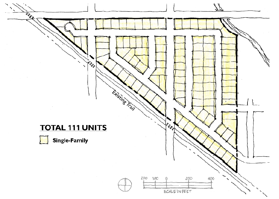
Example standard subdivision example with one hundred percent of lots single family.
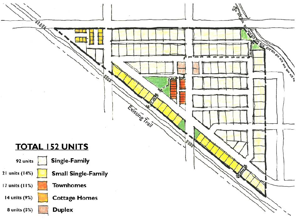
Example subdivision integrating missing middle housing types to achieve a density bonus. Using the calculations for available density bonuses for these housing types, the one hundred fifty-two dwelling units represented here would equate to one hundred twenty-three dwelling units for the purpose of density calculations. Missing middle housing types represent thirty-nine percent of the total dwelling units in this example - a percentage that would be acceptable in the RLD-8 zone.
(Ord. No. 1339, § 2(Exh. A), 5-27-2021; Ord. No. 1352, § 2(Exh. A), 11-4-2021; Ord. No. 1464, § 2(Exh.), 12-4-2025)
Editor's note— Ord. No. 1339, § 2(Exh. A), adopted May 27, 2021, amended § 18.210.030 in its entirety to read as herein set out. Former § 18.210.030 pertained to lot requirements and derived from Ord. No. 1132, § 2(Exh. A), adopted July 11, 2013; and Ord. No. 1207, § 2(Exh. A), adopted May 26, 2016.
18.210.035 - Reserved.
Editor's note— Ord. No. 1339, § 2(Exh. A), adopted May 27, 2021, repealed § 18.210.035, which pertained to green design and derived from Ord. No. 1254, Exh. 3, adopted Dec. 7, 2017.
18.210.040 - Setbacks—Exceptions.
A.
Reserved.
B.
Setbacks from Regional Utility Corridors.
1.
In subdivisions and short subdivisions, areas used as regional utility corridors shall be contained in separate tracts.
2.
In other types of land development permits, easements shall be used to delineate such corridors.
3.
All buildings and structures shall maintain a minimum distance of five feet from property or easement lines delineating the boundary of regional utility corridors, except for utility structures necessary to the operation of the utility corridor.
C.
Projections into Setback.
1.
The following projections may extend into yard setbacks:
a.
Gutters;
b.
Fixtures with a footprint not exceeding three square feet in area (e.g., overflow pipes for sprinkler and hot water tanks, gas and electric meters, alarm systems, and air duct termination; i.e., dryer, bathroom, and kitchens);
c.
On-site drainage systems;
d.
Fireplace structures, bay or garden windows, enclosed stair landings, closets, or similar structures may project into setbacks, that are greater than seven feet, provided such projections are:
i.
Limited to two per facade;
ii.
Not wider than ten feet;
iii.
Not more than twenty-four inches into a side yard setback which is greater than seven feet; or
iv.
Not more than thirty inches into a front and rear yard setback.
e.
Eaves shall not project more than:
i.
Eighteen inches into a required side yard setback; and
ii.
Thirty-six inches into a front yard and/or rear yard setback.
f.
Uncovered porches and decks not exceeding eighteen inches above the finished grade may project up to five feet into the rear yard setbacks in the RLD-4 and RLD-6 zone. For PUD subdivisions, refer to the setback modulation requirements in RDC 18.401.090.J.
g.
Covered but unenclosed porches may project up to three feet into the front yard.
h.
Building stairs associated with entrances and porches less than three feet and six inches in height are allowed to project into the front yard setback.
i
Arbors are allowed in a yard setback if:
i.
Their footprint is less than forty square feet, including eaves,
ii.
They are eight feet or shorter from finished grade, and
iii.
Both sides and roof are at least fifty percent open, or, if latticework is used, there shall be a minimum opening of two inches between crosspieces.
j.
Fences are allowed in a yard setback if they meet the requirements of RDC 18.740. Fences may not be placed in the public right-of-way.
k.
Retaining walls are allowed in a yard setback.
2.
No projections are allowed into a regional utility corridor.
3.
No projections or vertical structures are allowed into an access or stormwater easement.
D.
The front yard setback requirements are specified in Section 18.210.025, except as provided for below.
1.
The front yard setback may be reduced to the average front setback of the two adjacent lots; provided the applicant documents and demonstrates that the average setback of adjacent houses is less than fifteen feet. However, the minimum setback is ten feet. If the subject lot is a corner lot, the setback may be reduced to the average setback of the lot abutting the proposed house on the same street and the fifteen feet required setback. This provision shall not be construed as requiring a greater front yard setback than fifteen feet. Additionally, for corner lots the front yard setback along the longer side of the lot may be reduced to seven feet as long as this setback does not interfere with the site-triangle of the intersection.
E.
Alley-loaded lots. If the rear faces on an alley and automobile access is taken exclusively from the alley, the following exceptions apply:
1.
Minimum rear yard setback: zero feet.
2.
Minimum front yard setback: five feet. When the ground level of a dwelling unit is closer than ten feet from the front property line, the ground level shall be elevated a minimum of thirty inches above the average grade of the adjacent sidewalk.
3.
Lots intended for these reduced setbacks shall be noted on the plat.
4.
See related standards in RDC 18.210.090.C.
F.
Setbacks for flag lots shall be determined by the orientation of the house. The front setback shall be met for the side of the lot towards which the main entrance of the house is oriented, and rear and side yard setbacks shall be established in relationship to the front. All setbacks shall be measured from the property lines for the flag portion of the lot, and not from the pole portion of the lot. If the garage door is oriented towards the pole portion of the lot, it shall be set back eighteen feet from the property line of the flag portion of the lot to comply with RDC 18.210.090.B to allow sufficient driveway length to prevent parking in the pole portion of the lot.
(Ord. No. 1339, § 2(Exh. A), 5-27-2021; Ord. No. 1406, § 2(Exh. A), 7-13-2023)
Editor's note— Ord. No. 1339, § 2(Exh. A), adopted May 27, 2021, amended § 18.210.040 in its entirety to read as herein set out. Former § 18.210.040 pertained to dimensional standards and derived from Ord. No. 1132, § 2(Exh. A), adopted July 11, 2013; Ord. No. 1178, § 2(Exh. A), adopted Feb. 12, 2015; Ord. No. 1207, § 2(Exh. A), adopted May 26, 2016; and Ord. No. 1234, § 2(Exh. A), adopted June 22, 2017.
18.210.045 - Reserved.
Editor's note— Ord. No. 1339, § 2(Exh. A), adopted May 27, 2021, repealed § 18.210.045, which pertained to setbacks and exceptions and derived from Ord. No. 1132, § 2(Exh. A), adopted July 11, 2013; Ord. No. 1178, § 2(Exh. A), adopted Feb. 12, 2015; Ord. No. 1207, § 2(Exh A), adopted May 26, 2016; and Ord. No. 1232, § 2(Exh. A), adopted April 27, 2017.
18.210.050 - Green design.
A.
The purpose of this section is to ensure best practices of environmental stewardship within the city of Ridgefield and to protect, to the extent practicable, our natural environment for future residents.
B.
Development of single family residential uses within Ridgefield shall choose at least two practices from the list below during construction:
1.
Landscape with drought-tolerant, native plants
2.
Install water-conserving drip, micro-mist, or sub-surface irrigation systems
3.
Recycle, salvage, or donate excess or unwanted materials
4.
Recycle materials for use in walls, fences, trails, or other amenities that are integral to the development.
5.
Rain gardens to accommodate storm water on-site, particularly roof drains, rather than conveyance to a community system.
6.
Other green design practices that are acceptable to the community development director.
C.
See related standards for green building under RMC Chapter 14.32.
(Ord. No. 1339, § 2(Exh. A), 5-27-2021)
Editor's note— Ord. No. 1339, § 2(Exh. A), adopted May 27, 2021, amended § 18.210.050 in its entirety to read as herein set out. Former § 18.210.050 pertained to density requirements and derived from Ord. No. 1132, § 2(Exh. A), adopted July 11, 2013; and Ord. No. 1234, § 2(Exh. A), adopted June 22, 2017.
18.210.060 - Design provisions along major corridors.
A.
The following standards apply to all lots abutting or adjacent to the public rights-of-way of major corridors, which are defined as Hillhurst Road, Pioneer Street (east of the Gee Creek crossing), and Royle Road. Adjacent, when used in this section, means, separated by a street, tract, open space, or similar intervening element. These standards may not be modified through the Planned Unit Development (PUD) process. The six-foot height requirement for the fence or wall may not be modified through the administrative adjustment or variance processes.
B.
Setbacks. All yard setbacks for applicable lots are twenty-five feet from the property line.
C.
Fencing and Walls. All residential lots shall comply with the following fencing and wall standards in addition to RDC 18.210.110 and Chapter 18.740.
1.
Install a fence or wall continuously along major corridors as listed in subsection (A) of this section, and located directly behind the planting strip required in subsection (D) of this section. The fence or wall must comply with the site clearance provisions of Section 2.15 of the city engineering standards.
2.
The fence or wall must be a minimum of six feet high and be constructed to give the appearance of earth tone stone with columns or physical indentations in the fence or wall at least every fifty lineal feet to reduce the massing effect of the fence material. The fence or wall design shall be compatible with nearby fences and walls along the major corridors and shall match the design of any previous fences or walls in the same subdivision. The design shall be approved by the community development director.
3.
The property owner, developer or homeowners association is responsible for the maintenance of the fence or wall.
4.
The fence or wall shall not be built until the city issues a fence permit consistent with RDC 18.740.050, the city issues a building permit for a wall, or grants approval through the development review process.
D.
Landscaping. The following standards are in addition to the requirements in RDC 18.725. Figure 18.210.065-D is an example of design adhering to these standards.
1.
A minimum five-feet wide planting strip shall be required between the property lines of abutting lots, tracts or parcels and the required fence listed in subsection (C) of this section. Vegetation within this planting strip shall satisfy the following standards:
a.
Proposed vegetation shall be detailed in a landscape plan, consistent with the requirements of RDC 18.725.070, that addresses plant location, plant type, quantity, initial and mature planting sizes and method of irrigation.
b.
The planting strip shall be planted with a diverse mixture of evergreen trees, native shrubs and groundcover. Water features (creeks, fountains, etc.) may augment or replace the landscaping feature.
c.
All plantings shall remain fifty percent opaque year round.
d.
An in-ground irrigation system shall be installed to ensure the growth and long-term viability of planted materials.
e.
The perpetual maintenance and operation of the planting strip shall be the responsibility of a homeowner's association and/or the developer.
Figure 18.210.060-D
Major corridor plan-view example.
Figure 18.210.060-D.2
Major corridor cross section example.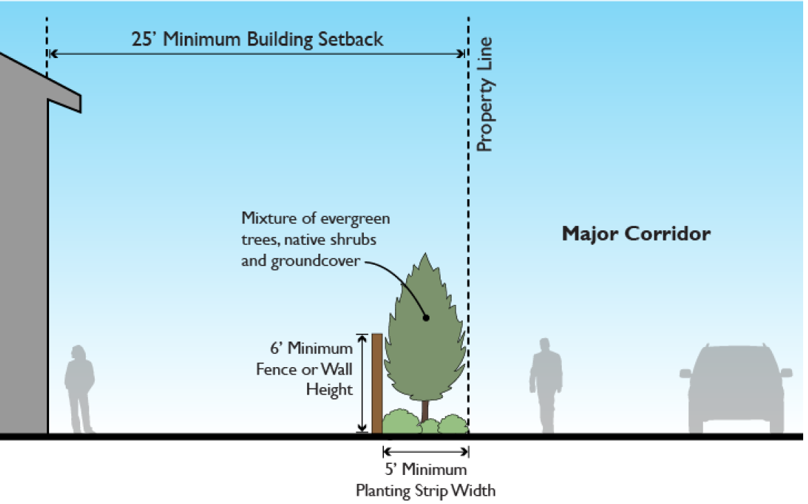
(Ord. No. 1339, § 2(Exh. A), 5-27-2021; Ord. No. 1426, § 2(Exh.), 7-25-2024; Ord. No. 1464, § 2(Exh.), 12-4-2025)
Editor's note— Ord. No. 1339, § 2(Exh. A), adopted May 27, 2021, amended § 18.210.060 in its entirety to read as herein set out. Former § 18.210.060 pertained to neighborhood design standards and derived from Ord. No. 1132, § 2(Exh. A), adopted July 11, 2013; Ord. No. 1232, § 2(Exh. A), adopted April 27, 2017; Ord. No. 1253, § 2(Exh. A), adopted Dec. 7, 2017; and Ord. No. 1325, § 2(Exh. A), adopted Sep. 24, 2020.
18.210.065 - Reserved.
Editor's note— Ord. No. 1339, § 2(Exh. A), adopted May 27, 2021, repealed § 18.210.065, which pertained to additional design provisions along major corridors and derived from Ord. No. 1132, § 2(Exh. A), adopted July 11, 2013; Ord. No. 1178, § 2(Exh. A), adopted Feb. 12, 2015; Ord. No. 1207, § 2(Exh. A), adopted May 26, 2016; Ord. No. 1225, § 2(Exh. A), adopted Dec. 1, 2016; Ord. No. 1232, § 2(Exh. A), adopted April 27, 2017; Ord. No. 1234, § 2(Exh. A), adopted June 22, 2017; and Ord. No. 1253, § 2(Exh. A), adopted Dec. 7, 2017.
18.210.070 - Signs.
A.
The city shall permit signs that comply with the provisions of Chapter 18.710.
(Ord. No. 1132, § 2(Exh. A), 7-11-2013)
18.210.075 - Exterior lighting.
A.
Lighting shall comply with the requirements of Chapter 18.715.
(Ord. No. 1132, § 2(Exh. A), 7-11-2013)
18.210.080 - Vehicles in residential zones.
A.
Purpose. Parking lots and outdoor storage of vehicles or recreational vehicles shall not be a primary use of any low density residential lot. Violation of this section is a public nuisance.
B.
Applicability. These regulations apply to all residential uses in RLD-4, RLD-6, and RLD-8 zones.
C.
Restrictions.
1.
Off-street parking is only permitted on approved driveways, parking lots or in garages.
2.
Passenger vehicles, light trucks and trucks under two ton gross weight may park in any approved parking area, including the street, or garage, so long as they do not pose an impediment to pedestrian or other vehicular traffic.
3.
Motor homes, recreational vehicles and utility trailers shall not be parked on street for a period of two weeks or more during any calendar year.
4.
Motor homes, recreational vehicles and utility trailers may be parked in off-street parking areas, including driveways, so long as no more than one is parked between the front lot line and the primary facade of the dwelling.
5.
Recreational vehicles are further subject to the provisions of RDC 18.205.020 and 18.205.030.
(Ord. No. 1132, § 2(Exh. A), 7-11-2013; Ord. No. 1426, § 2(Exh.), 7-25-2024)
18.210.090 - Off-street parking.
A.
Off-street parking shall comply with this chapter and Chapter 18.720, including the EV infrastructure requirements in RDC 18.720.040.C.8.
B.
For individual garage or carport units facing a street, at least twenty linear feet of driveway shall be provided between any garage or carport entrance and the property line abutting the street , measured along the centerline of the driveway. This standard shall not be modified through the adjustment or variance process per RDC 18.350 or the PUD process per RDC 18.401.
C.
For individual garage or carport units facing an alley, driveways shall not be any linear length between five feet and twenty feet from the garage or carport entrance to the edge of the alley; measured along the centerline of the driveway. The intent of this standard is to prevent parked cars from protruding into alleys. This standard shall not be modified through the adjustment or variance process per RDC 18.350 or the PUD process per RDC 18.401.
(Ord. No. 1132, § 2(Exh. A), 7-11-2013; Ord. No. 1207, § 2(Exh. A), 5-26-2016; Ord. No. 1339, § 2(Exh. A), 5-27-2021; Ord. No. 1464, § 2(Exh.), 12-4-2025)
18.210.100 - Landscaping.
A.
Landscaping shall meet the requirements of Chapter 18.725.
(Ord. No. 1132, § 2(Exh. A), 7-11-2013)
18.210.110 - Fences and walls.
A.
In addition to the provisions of Chapter 18.740, the following special provisions shall apply.
1.
The maximum height of fences located along a property line is six feet, subject to the sight clearance provisions of Section 2.16 of the city engineering standards. The maximum height of fences and walls located between the front yard building setback line and the front property line is three feet, six inches high.
2.
All electric, razor wire, and barbed wire fences are prohibited.
(Ord. No. 1132, § 2(Exh. A), 7-11-2013; Ord. No. 1370, § 2(Exh. A), 9-8-2022)
18.210.120 - Accessory structures.
A.
Accessory structures must meet the lot requirements and dimensional standards in RDC 18.210.030 with the following exceptions:
1.
Height.
a.
Accessory structures other than recreational vehicle garages shall not exceed the lesser of eighteen feet in height or the height of the primary structure.
b.
Recreational vehicle garages shall not exceed the lesser of twenty-four feet in height or the height of the primary structure.
2.
Setbacks.
a.
One uninhabited freestanding structure up to ten feet high and 120 square feet in footprint area, such as a storage shed or greenhouse, may be located within the required rear or side yard setback, provided:
i.
The structure shall be located a minimum of three feet from property lines with eaves no greater than twelve inches.
ii.
The structure shall retain a five-foot fire separation distance from other structures as specified in adopted building codes.
iii.
The structures shall be setback at least five feet farther than the front façade of the house if the structure is located in the side yard. For corner lots, the structure shall be set back a minimum of ten feet farther than the front façade of the house on the street side, or outside of the Sight Obstruction area pursuant to Section 2.16 of the Engineering Standards.
B.
Accessory structures greater than one hundred twenty square feet shall be visually compatible with the primary structure.
C.
Accessory structures are only permitted as accessory uses to a primary use and must be located on the same parcel as the primary use.
D.
Accessory dwelling units are regulated under RDC 18.205.020, RDC 18.205.030 and RDC 18.206.030.
(Ord. No. 1132, § 2(Exh. A), 7-11-2013; Ord. No. 1325, § 2(Exh. A), 9-24-2020; Ord. No. 1339, § 2(Exh. A), 5-27-2021; Ord. No. 1370, § 2(Exh. A), 9-8-2022; Ord. No. 1464, § 2(Exh.), 12-4-2025)
Editor's note— Ord. No. 1464, § 2(Exh.), adopted December 4, 2025, amended the title of § 18.210.120 to read as herein set out. The former § 18.210.120 title pertained to accessory structures and dwellings.
18.210.130 - Downtown transition area.
A.
Purpose. To accommodate potential future expansion of the CMU district, which encompasses the city's traditional commercial and civic core, the downtown transition area allows for limited commercial activity in the residential districts surrounding the CMU district.
B.
District Boundaries. The Downtown Transition Area (DTA) shall be bounded by the centerline of Sargent Street extended to 8 th Avenue, 8 th Avenue south of Pioneer Street, 5 th Avenue north of Pioneer Street, Division Street, and Railroad Avenue, exclusive of properties zoned RMD-16, CMU or P/OS. The district shall also include parcels abutting Division Street on the north side of the street between N Railroad Avenue and N 5 th Avenue, and parcels abutting Sargent Street on the south side of the street between S 3 rd Avenue and S 5 th Avenue. The district shall also include all parcels adjacent to the district boundaries. The district boundaries shall be as illustrated in Figure 18.210.130-B.
Figure 18.210.130-B
Downtown transition area boundaries.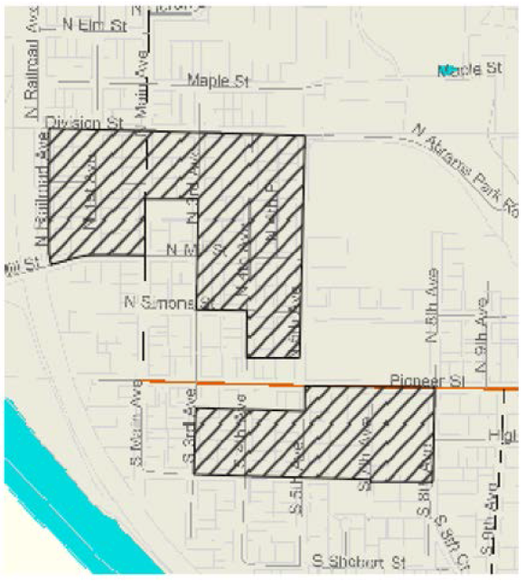
C.
Residential Uses. Within the downtown transition area, the following modifications to land use, dimensional, and density standards apply:
1.
Single family detached.
i.
For the purpose of density calculations, single-family detached dwellings one thousand six hundred square feet or less in gross floor area may count as one-half of one unit provided the lot is at least two thousand five hundred square feet and all applicable setback, open space, and design standards are met.
ii.
The density bonus available in this subsection shall not be combined with other density bonuses.
2.
Duplexes.
i.
Duplexes are allowed on all corner lots regardless of lot size or density requirements.
ii.
Duplexes are allowed on all lots at least four thousand seven hundred square feet in area regardless of density requirements.
D.
Nonresidential Uses. Within the downtown transition area, limited commercial and office activity may be allowed provided:
1.
Use is located on a lot platted ten thousand square feet or less zoned RLD.
2.
The building in which the use is located was lawfully established prior to the effective date of this ordinance. Existing buildings may be expanded by no more than twenty percent of the existing total floor area. Non-residential SDCs, impact fees, and building and life safety codes may apply to proposed alterations or expansions.
3.
Use meets the definition of general office, general retail trade/services, eating and drinking establishment use types as defined in RDC 18.100.
E.
Review. The community development director shall review applications for uses in the downtown transition area not allowed by the underlying zoning as well as proposed expansions and alterations consistent with RDC 18.210.130.C through a minor site plan review as described in RDC 18.500.030.B.
F.
Development Standards. The parking, landscaping, lighting, and sign standards for the CMU zone shall apply to proposed nonresidential uses in the DTA.
G.
Adjustment of Dimensional Standards for Building Expansions. The city will attempt to allow flexibility in lot coverage and dimensional standards set forth in RDC 18.210.030 so long as the adjustments to the standards are consistent with the character of the downtown transition area as follows:
1.
The burden of demonstrating that the proposed relaxation of the base zone dimensional standards is consistent with the character of the DTA lies solely on the applicant and shall be supported by substantial evidence, including, but not limited to, demonstrating consistency with the "14 Essential Guidelines for Downtown Ridgefield."
2.
Building setbacks to the street may be reduced if the proposed structure is of the same, or substantially similar, scale, mass, height and composition of materials as fifty percent of like types of buildings within a distance of two blocks of the proposed structure on the same street.
3.
The building height must meet the requirements for the underlying residential zone.
4.
The request for flexibility may exceed twenty percent of the numeric base zone standard without application of RDC 18.350.030.G.
(Ord. No. 1339, § 2(Exh. A), 5-27-2021)
Editor's note— Ord. No. 1339, § 2(Exh. A), adopted May 27, 2021, amended § 18.210.130 in its entirety to read as herein set out. Former § 18.210.130 pertained to special provisions for the downtown transition area and derived from Ord. No. 1132, § 2(Exh. A), adopted July 11, 2013; and Ord. No. 1178, § 2(Exh. A), adopted Feb. 12, 2015.
18.210.135 - Special provisions for the Gee Creek Plateau sub-area (Cluster Development).
A.
Purpose. The purpose of the Gee Creek Plateau cluster development is to accommodate urban densities of the underlying zoning district while allowing residential development to utilize less land area. These provisions aim to allow greater flexibility in the design of subdivisions to ensure development is in harmony with the natural characteristics onsite and to preserve features such as critical areas, open space, recreation areas, or scenic vistas.
B.
District Boundaries. The Gee Creek Plateau sub-area cluster development area (hatched area in the figure below) is bounded by the S. 5 th Way alignment to the north, approximately the S. 32 nd Place alignment to the west, Gee Creek to the south, and approximately the alignment of S. 40 th Street to the east. Cluster development within the district is required.
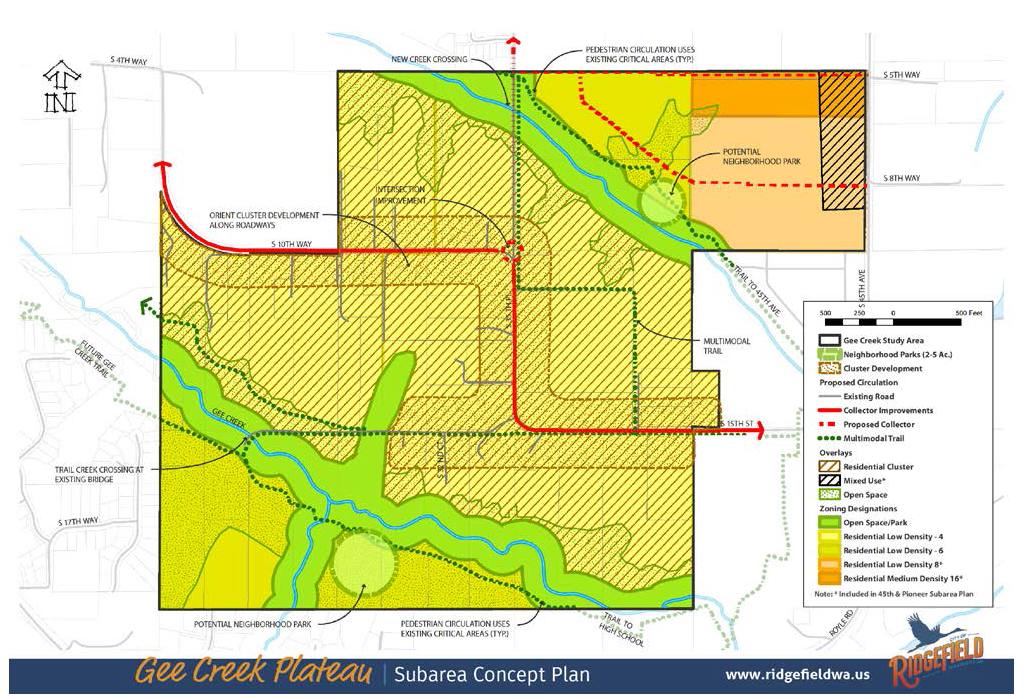
Figure 18.210.135-1
C.
Uses. The underlying base zone for all cluster development is Residential Low Density - 4 (RLD-4). Uses are those permitted in the RLD-4 zone.
D.
Review. The community development director shall review all development proposed under the Gee Creek Plateau cluster provisions as a planned unit development (RDC 18.401) and Procedures (RDC 18.310).
1.
The Gee Creek Plateau cluster development standards shall be required for development within the district boundaries identified by Section 18.210.135.B.
2.
The open space requirements in this section shall apply in lieu of the parks and open space requirements in Chapter 18.401.
3.
Critical areas density transfer provisions shall not apply within the required cluster district.
4.
The PUD process shall not be used to create lots exceeding these limits. The minimum lot size is six thousand square feet. The maximum lot size is fifteen thousand square feet.
E.
Development Standards. The clustering provisions of this code are required for any proposed development on parcels one acre or larger in size. Subdivisions of land within the cluster overlay of four lots or less shall follow the procedure outlined in RDC 18.610.
1.
Single family home lots shall be no less than six thousand and no more than fifteen thousand square feet with a minimum density of four dwelling units per acre based on net developable acres.
2.
The remainder parcel subject to covenant shall be no less than ten percent of the net developable area. For the purposes of this section a "remainder parcel" means the remainder parcel of the cluster subdivision that contains the majority of the land within the development and is devoted to open space uses.
3.
The remainder parcel shall be subject to a recorded covenant prohibiting any future development other than proposed trail development as identified in the parks and recreation capital facilities plan, or agricultural buildings. The purpose of the remainder parcel is to provide open space amenities to the development and preserve the unique nature of the Gee Creek Plateau.
a.
The remainder parcel shall be contiguous.
1.
The remainder parcel is encouraged to abut any critical area.
b.
The remainder parcel shall be dedicated to, and maintained by, the required home owners association (HOA).
4.
At minimum twenty-five percent of the road frontage of the parent parcel shall remain undeveloped in open space, except split rail fence, road and pedestrian improvements, and associated stormwater facilities.
a.
Corner lots may calculate the required twenty-five percent open space frontage by adding the total of both frontages. This requirement shall not be construed to require twenty-five percent of both frontages separately.
F.
This section becomes effective upon annexation.
(Ord. No. 1268, § 2(Exh. A), 10-25-2018; Ord. No. 1406, § 2(Exh. A), 7-13-2023)
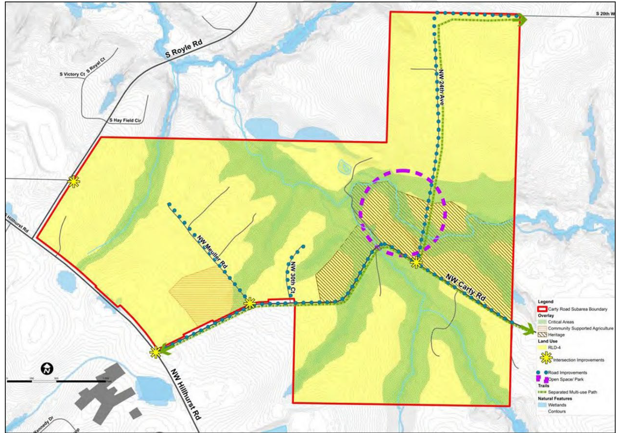
18.210.140 - Special provisions for the Carty Road subarea.
A.
Purpose. The purpose of the Carty Road subarea is to respect the rural and agricultural heritage of the area by protecting existing land uses and preserving open spaces.
B.
District Boundaries. The Carty Road subarea (outlined in red in the figure below) consists of approximately two hundred sixty-six acres in southern Ridgefield. The subarea is located east of the intersection of NW Hillhurst Road and South Royle Road and west of the Interstate 5 corridor. Northwest Carty Road functions as the southern boundary for a portion of the subarea. The subarea is located outside of the Ridgefield city limits within the city's urban growth area (UGA) in unincorporated Clark County. See figure 18.210.140-1.
Figure 18.210.140-1—Carty Road Subarea Preferred Concept Plan
C.
Guiding Principles. Development within the Carty Road subarea shall conform to the applicable Carty Road guiding principles:
1.
Respect the rural and agricultural heritage of the areas by protecting existing land uses and conserving open space.
2.
Create quality design through design standards and landscaping requirements.
3.
Respect existing development patterns in the Carty Road area.
4.
Protect natural areas and buffers along the Gee Creek corridor, including tributaries to Gee Creek.
5.
Provide transportation options that promote the safety of all users (motorists, cyclists, and pedestrians) and improve emergency vehicle access and evacuation options.
6.
Provide a range of development options for landowners that allow flexibility to retain existing uses and meet development regulations and state land use laws.
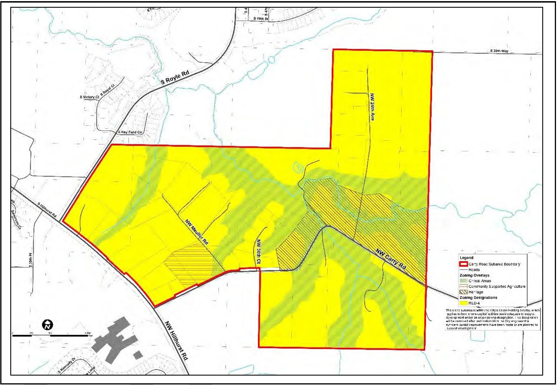
D.
Zoning and Uses. The underlying base zone for development is Residential Low Density - 4 (RLD-4). See Figure 18.210.140-2 Carty Road Future Zoning Map.
Figure 18.210.140-2—Carty Road Subarea Zoning Implementation Map
1.
Uses. Permitted (P), Limited (P-L) and conditional (C) uses in the Carty Road Subarea are listed in Table 18.210.140-1. Unlisted primary uses are prohibited.
Table 18.210.140-1—Carty Road Subarea Uses
Table Notes.
(1)
Residential uses shall comply with the architectural design, garage/driveway, usable outdoor space, and tree standards in RDC 18.206, residential use standards. Residential uses shall comply with the development, density, and environmental protection requirements in Section 18.210.140.
(2)
Accessory uses are only allowed on the same lot as a lawfully permitted primary use.
2.
Subdivision. Residential development in the Carty Road subarea shall comply with the applicable general subdivision standards in RDC 18.600 through 18.640. Planned unit developments (PUDs), as described in RDC 18.401, do not apply in the Carty Road subarea. The special subdivision standards are instead as follows.
a.
The minimum area of a new residential lot may not be less than nine thousand eight hundred square feet.
b.
The maximum area of a new residential lot may not exceed sixteen thousand three hundred fifty-five square feet except under the one-time two-lot short plat exemption described in RDC 18.210.030.B.1.
c.
The density of the subdivision shall be four units per net developable acre. Rounding is permitted.
d.
The subdivision shall incorporate a twenty-foot wide perimeter compatibility landscape buffer.
i.
The perimeter compatibility buffer is required between the subdivision and adjacent residential properties except where the adjacent property has been subdivided, is subject to an application for subdivision, or where the owner of the adjacent property certifies their intent to subdivide.
ii.
The perimeter compatibility buffer shall be located in a separate tract or tracts which shall be owned and maintained by the HOA.
iii.
One hundred percent of the plant material within the twenty-foot buffer shall be native plants. (See RDC 18.830.) The buffer shall be vegetated with the equivalent of dense evergreen shrubbery or evergreen understory trees at eight-foot on center, and trees at twenty-five feet on center. Existing native vegetation shall be retained to the extent practicable to meet this requirement.
iv.
The twenty-foot wide perimeter compatibility landscape shall comply with the requirements for landscape plans, installation, and monitoring in RDC 18.725.
v.
Trails are permitted in the perimeter compatibility buffer.
vi.
Only a type B1 earthen berm or S1 site-obscuring fence may be permitted in the perimeter compatibility buffer.
vii.
Walls, berms, or fences may not be used as a means to reduce the twenty-foot perimeter compatibility standards.
e.
Any application for a subdivision shall include a master plan which complies with the standards in subsections 18.210.140.D.2.a through f and:
i.
Identifies prominent view sheds from public rights-of-way and shall plat lots to maximize the identified view sheds.
ii.
Identifies existing conditions, including but not limited to, native soil, existing tree cover, and topography, and shall preserve such existing conditions to the greatest extent practicable, as determined by the community development director.
iii.
Provides a multi-modal trail network that connects to a public right-of-way which provides transportation and recreational opportunities throughout the Carty Road subarea and allows future connection to the larger Ridgefield and regional trail system.
3.
Dimensional Standards. In addition to the standards enumerated in (2), the standards in Table 18.210.040-2 apply to individual lots in the Carty Road subarea.
Table 18.210.040-2—Carty Road Subarea Dimensional Standards
Table Notes.
(1)
Setbacks are measured from the property line of the subject lot.
(2)
Setbacks may not be reduced to less than those provided for the RLD-4 zone in RDC 18.210.030.
(3)
The twenty-five-foot setback along NW Carty Road may not be reduced.
4.
Design Provisions Along Carty Road. A separate landscape tract(s) to be owned and maintained by the HOA shall be located between the back of the sidewalk and the property line.
a.
The landscape tract shall be an average of fifteen feet wide. The width may vary to accommodate a meandering sidewalk.
b.
The landscape tract shall be vegetated with a diverse mixture of native evergreen trees, native shrubs, and native groundcover. Existing native vegetation shall be retained to the extent practicable to meet this requirement. Proposed vegetation shall be detailed in a landscape plan consistent with the requirements of RDC 18.725.070.
5.
Special Provisions for Carty Road Community Supported Agriculture (CR-CSA) Overlay.
a.
Purpose. To encourage the creation of limited commercial uses or event facilities in tandem with residential uses that support the selling or promotion of local agricultural or ancillary products.
b.
Special Provisions for Community Gardens.
i.
Outdoor display related to the function of the community garden is allowed.
ii.
A community garden may install one monument sign up to a maximum of ten square feet, subject to obtaining a city sign permit,
c.
Special Provisions for Farmer's Markets.
i.
Parking is required consistent with RDC 18.720, parking and loading, at a rate of one parking space for every two hundred fifty square feet of booths or stalls.
ii.
Outdoor display related to the function of the farmer's market is allowed.
iii.
A farmer's market may install one monument sign up to a maximum of thirty-two square feet, subject to obtaining a city sign permit,
iv.
Sales are allowed only between seven a.m. and seven p.m.
v.
Sales are allowed up to one hundred eighty days in each calendar year. A farmer's market must obtain a special event permit which shall be limited to a maximum of one hundred eighty days within a three hundred sixty-five-day period
vi.
The operator of a farmer's market shall obtain a city business license and is responsible for compliance with applicable regulations.
d.
Special Provisions for Food Distribution Membership.
i.
Members may pick up items at the site only between seven a.m. and seven p.m.
ii.
Deliveries are allowed between eight a.m. and five p.m.
iii.
Exterior activities, except delivery and pick up, may not occur in the area between the primary building and any street lot line.
iv.
The operator of a site shall obtain a city business license and is responsible for compliance with applicable regulations.
e.
Special Provisions for Commercial Market Gardens.
i.
Outdoor display related to the function of the market garden is allowed.
ii.
A market garden may install one monument sign up to a maximum of ten square feet, subject to obtaining a city sign permit.
iii.
Only food and value-added products made from materials grown and raised on-site may be sold.
iv.
Sales are allowed only between seven a.m. and seven p.m.
v.
The operator of a site shall obtain a city business license and is responsible for compliance with applicable regulations.
6.
Special Provisions for the Carty Road Heritage (CR-H) Overlay.
a.
The purpose of the CR-H overlay is to encourage the preservation and continued use of historic properties and structures listed on county, state, and national registers.
b.
New development within the CR-H overlay shall provide a minimum thirty-foot wide front yard, perimeter compatibility landscape buffer between existing and new uses along the length of the front yard.
i.
The thirty-foot wide buffer shall be planted with dense shrubbery, ground cover and trees planted at a minimum of twenty feet on center, similar to an L5 standard.
ii.
The thirty-foot buffer may not be altered.
c.
New cultural, religious, and community institutions are subject to the provisions of RDC 18.500, site plan review, including architectural design review.
d.
Community gardens are subject to the provisions in RDC 18.210.140.D.4.b.
7.
Carty Road Critical Areas (CR-CA).
a.
The provisions of RDC 18.280, critical areas protection, apply; provided that:
i.
Impacts to critical areas and buffers are prohibited with the following exceptions:
(A)
Public right-of-way may impact critical areas when the applicant demonstrates that avoidance is not a reasonable option. Mitigation ensuring no net loss of function per RDC 18.280 is required.
(B)
Approved essential public infrastructure including utilities, stormwater facilities, parks, and trails may be located in the outer twenty-five percent of a buffer. Mitigation ensuring no net loss of function per RDC 18.280 is required.
ii.
Critical area buffer reduction is prohibited.
iii.
Critical area buffer averaging in accordance with RDC 18.280 is permitted as part of a master plan demonstrating compliance with the Carty Road subarea plan.
E.
Engineering. Development in the Carty Road subarea shall be subject to the requirements of the Ridgefield Engineering Standards for Public Works Construction including Transportation Details T-2.19 (Carty Road Subarea Collector Section) and T-2.20 (Carty Road subarea residential local A Section).
F.
Applicability. Section 18.210.140 becomes effective upon annexation.
(Ord. No. 1440, § 2(Exh. A), 2-27-2025)
Editor's note— Ord. No. 1339, § 2(Exh. A), adopted May 27, 2021, repealed § 18.210.140, which pertained to special provisions for townhouse developments and derived from Ord. No. 1132, § 2(Exh. A), adopted July 11, 2013. Subsequently, Ord. No. 1440, § 2(Exh. A), adopted February 27, 2025, enacted a new § 18.210.140 as set out herein.
18.210.150 - Reserved.
Editor's note— Ord. No. 1339, § 2(Exh. A), adopted May 27, 2021, repealed § 18.210.150, which pertained to special provisions for cottage, carriage and two/three unit homes and derived from Ord. No. 1132, § 2(Exh. A), adopted July 11, 2013; and Ord. No. 1207, § 2(Exh. A), adopted May 26, 2016.