
Saint Leo City Zoning Code
ARTICLE VII
ZONING DISTRICTS
Sec. 7.1.- Establishment of zoning districts.
For the purposes of this ordinance and consistent with the comprehensive plan, the Town of St. Leo is hereby divided into the following zoning districts. These zoning or overlay districts use the same nomenclature as the Town of St. Leo Comprehensive Plan land use categories:
Agricultural district (A).
Rural density residential (RDR).
Low density residential (LDR).
Medium density residential (MDR).
Business district (B).
Institutional district (IL).
Permanently open land (POL).
Conservation overlay district (CON).
(Ord. No. 11-01, § 2, 1-10-2011)
Sec. 7.2. - Zoning district boundaries.
A.
The boundaries of the zoning districts defined in Section 7.1 are hereby established on the Official Town of St. Leo Zoning Map, adopted on November 10, 2025, and as may be amended by the Town of St. Leo Town Commission.
B.
The zoning district boundaries on the official Town of St. Leo zoning map are intended to follow property lot lines as depicted on the Pasco County Property Appraiser plat maps and/or the centerline of road rights-of-way. The zoning district boundaries are also intended to coincide with the land use category boundaries as depicted on the comprehensive plan future land use map. Where a zoning district boundary line does not clearly coincide with a property lot line, or any of the lines previously mentioned, its boundaries shall be determined by the town commission.
C.
For purposes of implementing the areas of permanently open land, permanently open land, at minimum, (1) shall extend away (landward or upland) from the established Southwest Florida Water Management District (SWFWMD) High Minimum Lake Level (HML) mark for Lake Jovita, which is defined as the 127-foot contour line above the National Geodetic Vertical Datum (NGVD) for 100 feet, and (2) shall extend 100 feet on either side of the center line of the waterway (notwithstanding the fact that waterway may be dry from time to time) which connects and runs between Lake Jovita and the Abbey Golf Course (south, southeast from the shoreline of Lake Jovita.
(Ord. No. 11-01, § 2, 1-10-2011; Ord. No. 26-02, § 3(Exh. B), 11-10-2025)
Sec. 7.3. - Permitted uses.
Table A identifies the range of permitted, conditional or special exception uses for each zoning district. All principal uses, except agricultural uses, shall be located within a permanent building(s). Uses not delineated in the table may be presented for consideration by the town commission which are determined to be the same general character such as, but not limited to, those listed as permitted uses, and which will not be detrimental to the health, safety, morals and general welfare of the district in which they are located.
ARTICLE VII—TABLE A
Zoning District Uses
Notes:
1 Symbols: P = Permitted use; C = Conditional use; SE = Special exception use.
2 These uses have special requirements that are enumerated in Article VIII—Special exception and conditional uses.
ARTICLE VII—TABLE A (Continued)
Zoning District Uses
Notes:
1 Symbols: P = Permitted use; C = Conditional use; SE = Special exception use.
2 These uses have special requirements that are enumerated in Article VIII—Special exception and conditional uses.
3 All vehicle or other repairs, including tire changing, shall be conducted within an enclosed building or structure. No outdoor storage or display of items for sale is permitted.
4 These public/semi-public uses may only be considered for developments one acre or less in size.
5 These public/semi-public uses may only be considered for developments less than five acres in size.
(Ord. No. 11-01, § 2, 1-10-2011; Ord. No. 13-03, § 4, 2-11-2013; Ord. No. 19-05, § 2, 1-14-2019; Ord. No. 24-04, § 1, 1-8-2024; Ord. No. 26-02, § 3(Exh. B), 11-10-2025)
Sec. 7.3.1. - Conservation overlay district (CON) uses.
A.
Lands designated with the conservation (CON) future land use category are subject to the conservation overlay district requirements. Land designated with the CON land use category may include, but are not limited to, wetlands, significant wildlife habitats and environmentally sensitive areas identified as part of any development approval by the town. Areas identified as open space by the town may also be designated with the conservation overlay district. No development or use is permitted within the CON overlay district, except for nature trails/boardwalks and associated parking areas and information kiosks.
B.
The CON overlay district boundary is not treated as a zoning district boundary. Therefore, adjacent structures are not required to meet setback requirements, unless the overlay district is also a property boundary or if overlay district is a preserved jurisdictional wetland as described in Section 7.11. All structures, roads and parking areas adjacent to a wetland shall be set back 25 feet from all jurisdictional wetland boundaries.
(Ord. No. 11-01, § 2, 1-10-2011; Ord. No. 26-02, § 3(Exh. B), 11-10-2025)
Sec. 7.4. - Accessory uses, buildings/structures and permitted encroachments.
A.
Accessory uses and accessory buildings or structures are customarily subordinate or incidental to the principal use pursuant to Article VII, Table A. Such accessory structures may include swimming pools (enclosed or not enclosed), docks, detached garage, storage sheds (up to 200 square feet in size), open patios, decks, freestanding canopies/gazebos and fences or reclaimed water or stormwater ponds with or without floating solar facilities. When accessory and principal uses are under a continuous (solid) roof, or within five feet of each other at the closest point, the entire structure shall meet setbacks required for the principal structure or use. Specific requirements pertaining to the determination of what is incidental and subordinate for certain types of accessory uses shall be determined by the town commission or its designee.
B.
Accessory structures may be located on a property provided the following requirements are met, except as regulated herein in this article:
1.
There shall be a permitted principal use on the property, unless otherwise exempted by this article.
2.
Accessory structures shall not be located in a required buffer or in the required front yard setback.
3.
Accessory structures, except fences, walls and docks, may be located in the side or rear yard setback area provided the accessory structure is not more than ten feet in height and located with a minimum five-foot rear and/or side yard setback. Any accessory structure more than ten feet in height shall only be located in the rear yard and must meet the zoning district rear and side yard setback and height requirements.
4.
All accessory structures shall be included in the calculation of floor area ratio (FAR) and impervious surface ratio (ISR), except for floating solar facilities components located within the area of a stormwater or reclaimed water pond.
5.
The number of accessory structures on a property shall be limited to two structures, excluding fences, walls, pools and reclaimed water or stormwater ponds with or without floating solar facilities and any associated solar facilities; and except for accessory structures located within the POL district.
6.
Accessory structures, including fences, walls and docks/boathouses, within the permanently open lands (POL) zoning district shall be designed and located to minimize their obstruction or degradation of lake front view corridors.
C.
Certain building encroachments may be permitted into front and rear required setbacks. These include the following:
1.
Roof overhangs, bay windows, porches, decks, and exterior stairs may encroach into the required front or rear yard set back by three feet.
D.
Fences or walls.
1.
Fences or walls may be constructed in the front yard or along the front yard property boundary provided the fence is constructed parallel with the front of the principal structure and does not exceed four feet in height. Fences or walls may be located in the side or rear yard and constructed along the side yard or rear yard property boundary and shall be limited to six feet in height.
2.
All fencing or walls shall be of uniform building materials and color.
3.
All fencing or walls shall be constructed of commonly used materials such as chain link, wrought-iron, aluminum, wood, plastic (PVC) or masonry. Masonry block walls, except brick, shall have a finished appearance such as a stucco finish on the exterior. Wood fences shall have the finished side facing the street and abutting properties. Fences constructed of scrap metal or other offensive materials are prohibited.
E.
Docks and related structures.
1.
No dock or related structures (herein to be included in the term dock) shall be constructed without approval of a dock application-general site plan by the town commission or its designee, and any other permit approvals required by other agencies with jurisdiction over Lake Jovita.
2.
Any dock constructed prior to the adoption of this chapter shall only rebuild in compliance with this chapter. Further any existing docks shall not expand in size, height, length or add any roofed structures, unless approved by the town commission in accordance with the requirements regarding nonconformities in article V.
3.
All applications for review of a proposed dock shall be in compliance with the submittal requirements set forth in article X for a general site plan and the following additional requirements:
a.
A survey of the property including the topographic vertical contour showing the mean high-water mark.
b.
A scaled (not greater than one-inch equals 50 feet) dimensioned site plan and elevation drawing showing dock square footage and height of the dock and any related structures, dock setbacks from adjacent properties, lake shoreline and location of the mean high-water mark. In addition, the drawing shall show any other accessory structures within the permanently open land (POL) zoned portion of the property, including their location, size, height and dimensions.
c.
Copies of any required approvals or exemptions from other governmental and non-governmental regulatory agencies.
4.
All docks shall meet the following requirements:
a.
Only one dock shall be permitted for each Pasco County Property Appraiser folio/parcel number existing as of July 1, 2018, and consisting of a total of 30 parcels as depicted on the "Lake Jovita Bathymetric Contours" map dated July 1, 2018, maintained in the town's records.
b.
The following requirements relative to lake frontage and dock length, area and height shall be based on the established Southwest Florida Water Management District (SWFWMD) High Minimum Lake Level (HML) mark for Lake Jovita, which is defined as the 127-foot contour line above the National Geodetic Vertical Datum (NGVD).
i.
All docks shall be set back a minimum of 15 feet from the property line. All roofed areas must be set back a minimum of 25 feet from the property line.
ii.
The total dock area whether permanent or floating or any combination thereof shall not exceed 850 square feet in surface area, including roofed structure and boat slip area, as measured from the HML. Any portion of the dock/walkway area landward of the HML shall not be included in the total dock area calculation.
iii.
The dock deck, except for floating docks, shall be a minimum of six inches or 0.5 feet above the HML, but not to exceed two feet above HML.
iv.
The height of any roofed structure shall not exceed 15 feet above the dock deck to the roof peak.
v.
Based on the gentle slope of bathymetric contours in the north and southeast sections of Lake Jovita, the following 12 parcels as identified by Pasco County Property Appraiser parcel numbers in effect on August 1, 2018, shall be limited to a permanent or floating dock or any combination thereof extending a maximum of 100 feet into the lake as measured from the HML: 01-25-20-0000-00300-0010, -00300-0011, -00400-0000, -00400-0030, -00400-0032, -00700-0000, -00900-0000, -00600-0000, -00200-0000, -03000-0010, 03000-0000, and -00100-0010. No other permanent or floating dock or any combination thereof, shall extend more than 50 feet into the lake as measured from the HML.
vi.
Based on their location adjacent to the canal extending north from Lake Jovita, the following four parcels identified by the Pasco County Property Appraiser parcel numbers in effect as of July 1, 2018, shall be limited to a permanent or floating dock or any combination thereof extending a maximum of 25 percent of the width of the canal as measured from the HML: 01-25-20-0000-00400-0020, -00500-0000, -00400-0050, -00400-0010, The total dock area whether permanent or floating or any combination thereof shall not exceed two square feet for every foot of the subject frontage along the canal. Total dock area includes roofed structure and boat slip area as measured from the HML. A minimum five foot setback shall be provided from all property lines and a minimum 25-foot setback shall be provided from an existing dock structure on adjacent properties. All other provisions of this section not modified by this paragraph shall apply.
vii.
Based on their location at the mouth of the canal and Lake Jovita, the following two parcels identified by the Pasco County Property Appraiser parcel numbers in effect as of July 1, 2018, require special regulations to ensure docks located on these properties which may extend up to 100 feet into Lake Jovita from the HML, do not limit navigation to and from the canal: 01-25-20-0000-00900-0000 and 01-25-20-0000-00600-0000. Any permanent or floating dock or any combination thereof located on these lots shall be located along the southern property line of parcel 01-25-20-0000-00900-0000 and the eastern property line of parcel 01-25-20-0000-00600-0000. The minimum setback from any property line shall be 15 feet for docks with or without roofed structures. The minimum setback from an existing dock structure(s) on an adjacent property shall be 25 feet to preserve the navigability of the canal channel. The required 15-foot minimum setback may be reduced to 5 feet along the southern property line of parcel 01-25-20-0000-00900-0000 and the eastern property line of parcel 01-25-20-0000-00600-0000 with the written consent of the adjoining property owner(s) as provided to and acknowledged by the town commission through the dock approval process. Any dock on these parcels constructed prior to the adoption of this section and chapter shall only rebuild in compliance with this section and this chapter. Any existing docks shall not expand in size, height, length or add any roofed structures, unless approved by the town commission in accordance with the requirements regarding nonconformities in article V. All other provisions of this section not modified by this paragraph shall apply.
c.
Any roofed structure on a dock shall be open on all sides, shall be a pitched roof and shall not exceed 500 square feet in size. The roofed structure shall not extend more the two feet beyond the perimeter of the dock, including the slip area.
d.
All docks shall provide sufficient reflective materials or devices visible at night on all sides of the dock to provide for nighttime boating safety.
e.
No bathroom, cooking or flammable fueling facilities shall be permitted on any dock.
f.
A dock shall be limited to one boat slip and not more than a total of three motorized watercraft berthed/moored at the dock.
g.
No dock shall obstruct or restrict water access to or on the lake or obstruct any canals.
h.
Any flotation material used in floating docks shall be fully encapsulated; suitable for marine use; resistant to puncture, fire, cracking, peeling, or loss of pellets; and generally impervious to water or fuel damage.
(Ord. No. 11-01, § 2, 1-10-2011; Ord. No. 18-05, § 1, 7-9-2018; Ord. No. 20-01, § 3, 1-13-2020; Ord. No. 21-04 § 1, 2-08-2021; Ord. No. 26-02, § 3(Exh. B), 11-10-2025)
Sec. 7.5. - Development requiring planned unit development (PUD) review and approval.
A.
Any proposed residential or institutional development of five acres or more, except for platting of subdivisions pursuant to article XIV, or any proposed commercial (office and/or retail) or mixed-use development of three acres or more is required to be reviewed and approved through the PUD process pursuant to article X. A planned unit development is a large-scale project constructed by a single owner or group of owners acting jointly and involving a related group of existing and/or proposed uses planned, developed, and regulated as an entity.
B.
Proposed minor changes to established institutional uses, in existence on this chapter's effective adoption date, may be declared exempt from the planned unit development review process by the town commission provided that:
1.
The proposed construction and/or project phasing does not exceed a total of 10,000 square feet of gross floor area and is not greater than 35 feet in height.
2.
It is not the intent of this section to permit incremental project submittals to avoid the threshold requirement for a PUD review. Therefore, the town commission may require a PUD review if it is deemed appropriate.
(Ord. No. 11-01, § 2, 1-10-2011; Ord. No. 20-01, § 2, 1-13-2020)
Sec. 7.6. - Outdoor display and storage.
Outdoor storage of vehicles and/or products is prohibited except for approved vehicle sales/display or storage related to an approved mini-warehouse use and temporary storage of materials related to new construction pursuant to Section 8.3, temporary uses.
(Ord. No. 11-01, § 2, 1-10-2011)
Sec. 7.7. - Zoning districts dimensional standards.
Table B identifies the development dimensional standards that apply to each zoning district. Pursuant to Article X, Planned Unit Development (PUD), these standards, excluding density and FAR limits, may be waived as part of the PUD process at the discretion of the town commission. In calculating the maximum permitted number of dwelling units or floor area (square feet), any fraction thereof shall be rounded down to the next whole number.
ARTICLE VII—TABLE B
Zoning Districts Dimensional Standards Matrix
Notes:
1 Special building setbacks: See Sections 7.9 and 7.10.
2 Accessory structures and encroachments: See Section 7.9.
3 On corner lots, the smallest street frontage dimension shall be considered the front yard and the other street side shall be considered a street side yard. On through lots, there shall be two front yards. The two smallest street frontage dimensions shall be considered the front yards and the other street side shall be considered a street side yard.
4 Building height may be increased one foot for every two feet of additional building setback on all sides, up to a maximum height of 75 feet in the IL district and 50 feet in the B, MDR and A districts. Appurtenances such as antennas, steeples and chimneys may not extend more than ten feet above the roof peak.
5 Only accessory structures related to the residential, recreational or park use or public structures are permitted in this district. Accessory structures and uses relative to a golf course use may include driving ranges, pro-shops, clubhouses/recreation facilities, and restaurants. See Section 7.9 for accessory structures related to residential use.
6 A density of up to four units/acre may be permitted as a PUD pursuant to the Town of St. Leo Comprehensive Plan.
7 Mixed uses (residential and commercial) permitted pursuant to Town of St. Leo Comprehensive Plan.
8 Development between five and less than ten acres, the maximum ISR is 0.6 and development of five acres or less, the maximum ISR is 0.7.
(Ord. No. 11-01, § 2, 1-10-2011; Ord. No. 13-03, § 5, 2-11-2013; Ord. No. 26-02, § 3(Exh. B), 11-10-2025)
Sec. 7.8. - Lots.
A.
Lots, measurement of width. The width of a lot shall be measured across the rear of the required front yard setback. The width of lots fronting on curves or culs-de-sac shall be measured as a straight line tangent to the midpoint of the arc of the curve formed by the building line. This building line may be equal to or greater than the required front yard of the zoning district. In addition, when a lot fronts on a cul-de-sac or curve, the lot width along the street frontage shall be measured as a straight line tangent of the midpoint of the arc of the curve along the street frontage and shall be a minimum of 20 feet.
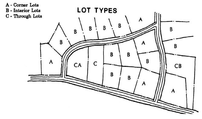
B.
Lots, types. Figure A illustrates terminology used herein with reference to describing lot types such as corner, interior, and through lots.
C.
Lot frontage.
1.
On interior lots, the front of a lot shall be construed as the portion nearest the street.
2.
On corner lots, the frontage of a lot shall be construed as the shortest boundary to a street. If the lot has equal frontage on two or more streets, frontage shall be determined by the town commission or its designee in accordance with the prevailing building pattern, or the prevailing lot platting pattern, if a building pattern has not been established.
3.
On through lots, there shall be two front yards. The two smallest street frontage dimensions shall be considered the front yards and the other street side shall be considered a street side yard. If the town commission or its designee finds that the pattern of lots or the pattern of required yards, on lots adjacent to portions of the through lot, is such as to justify the elimination of the requirement that more than one frontage be provided on the lot, such additional frontage shall not be required.
ARTICLE VII—FIGURE A
(Ord. No. 11-01, § 2, 1-10-2011)
Sec. 7.9. - Special building and accessory structure setbacks.
A.
Lake Jovita. All building and septic system setbacks from Lake Jovita shall be measured 100 feet landward from the Southwest Florida Water Management District (SWFWMD) High Minimum Lake Level (HML) mark for Lake Jovita, which is defined as the 127-foot contour line above the National Geodetic Vertical Datum (NGVD). This is the area defined as the permanently open land (POL) zoning district. This area is intended to be retained in a natural vegetative state. The setback area shall not be used for residential structures. Permitted structures in the setback area may include accessory structures such as docks, decks, swimming pool, arbors, gazebos or similar structures provided such structures are open on all sides. Only one accessory structure, excluding fences, walls, pools and docks is permitted, and shall not be more than 400 square feet in size and ten feet in height. The setback area may be used for an approved SWFWMD stormwater facility provided such facility meets landscape buffer requirements.
B.
County Road 52. All building setbacks shall be 50 feet from the right-of-way line. The setback area shall not be used for accessory structures, but may be used for unfenced stormwater facilities and/or parking.
(Ord. No. 11-01, § 2, 1-10-2011; Ord. No. 26-02, § 3(Exh. B), 11-10-2025)
Sec. 7.10. - Affordable/workforce housing bonus.
A.
Purpose and intent. To provide a density bonus of up to one dwelling unit/acre for development within any residential or business land use category to encourage construction of affordable/workforce housing and establish criteria and development standards for achieving the bonus.
B.
Affordability is defined as gross family income that is below 80 percent of the median income adjusted for family size or as may be established by federal, State of Florida or Pasco County.
C.
Criteria.
1.
Development must include a minimum of 20 percent of the total number of dwelling units as affordable.
2.
Provide assurances that the housing will remain affordable for a minimum of 15 years from receipt of a certificate of occupancy for the unit via deed restrictions, covenants or other acceptable guarantee.
(Ord. No. 11-01, § 2, 1-10-2011)
Sec. 7.11. - Special requirements for environmentally sensitive areas and historic resources.
This section addresses historic resources and environmentally sensitive areas that include jurisdictional wetlands, wellheads and wildlife habitats. Other environmentally sensitive areas such as hillsides, floodplains and lakes are addressed by other articles in this chapter. The purpose and intent of this section is to direct incompatible land uses and development away from environmentally sensitive areas and establish setback and other development standards to minimize impacts.
A.
Wetlands.
1.
Potential wetlands as identified by Pasco County have been delineated on the Comprehensive Plan Map Series, "Environmentally Sensitive Land Features." New proposed development containing wetlands (as approved and delineated by SWFWMD) shall preserve the wetland area or mitigate wetland as permitted by SWFWMD.
2.
A minimum development setback buffer area of 25 feet shall be established around the preserved final delineated jurisdictional wetland.
3.
All preserved final delineated jurisdictional wetlands shall be dedicated as a permanent open space or conservation easement pursuant to F.S. § 704.06, and be shown as preserve areas on site plans and/or plats as applicable. The Town shall encourage applicants to designate these areas with a conservation (CON) district overlay and on the comprehensive plan future land use map (FLUM) as conservation. Said land use designation shall occur as part of future evaluation and appraisal report based amendments.
B.
Wildlife habitat.
1.
Potential critical wildlife habitat areas have been delineated on the Comprehensive Plan Map Series, "Environmentally Sensitive Land Features." New development containing a potential listed species wildlife habitat shall provide a habitat survey by qualified professionals delineating the habitat types for state and federal listed species and applicable areas.
2.
The minimum area to be preserved shall be determined by the town commission based on the survey and proposed development. However, no more than 50 percent of the total listed species habitat area can be encroached with development. Any encroachment shall require mitigation of impacts as permitted by FWC.
3.
A minimum development setback buffer area of 25 feet shall be established around the preserved habitat area.
4.
All preserved final delineated habitat area shall be dedicated as a permanent open space or conservation easement pursuant to F.S. § 704.06, and be shown as preserve areas on site plans and/or plats as applicable. The town shall encourage applicants to designate these areas with a conservation (CON) district overlay and on the FLUM as conservation. Said land use designation shall occur as part of future evaluation and appraisal report based amendments.
C.
Wellhead protection areas.
1.
Wellhead protection areas have been delineated on the Comprehensive Plan Map Series, "Environmentally Sensitive Land Features." New development within a wellhead protection area may have use limitations. Review of activities and uses within wellhead protection areas will be pursuant to the Pasco County Land Development Code Section 308, Groundwater Protection and all subsequent amendments.
D.
Historic resources.
1.
Historic resources are delineated on the Comprehensive Plan Map Series, "2045 Future Land Use Map." Development adjacent to these resources will be reviewed for design compatibility based on United States Secretary of the Interior standards.
(Ord. No. 11-01, § 2, 1-10-2011; Ord. No. 26-02, § 3(Exh. B), 11-10-2025)