
Seabrook Island City Zoning Code
ARTICLE 8
OVERLAY DISTRICTS1
Editor's note— Ord. No. 2024-06, § 2, adopted December 17, 2024, amended the title of At. 8 to read as herein set out. The former Art. 8 title pertained to Seabrook Island Road Overlay District.
Section 8.1 - Seabrook Island Road Overlay District
A.
Purpose. As the only public right-of-way providing access to and from the TOWN, it is essential that Seabrook Island Road be maintained as a safe, efficient, functional, and attractive corridor. The Seabrook Island Road OVERLAY DISTRICT is established for that purpose. Regulations are established by this section to manage access to and from abutting properties, create an inviting and unified appearance along the corridor, protect the corridor's prized natural features, promote alternate modes of transportation, and preserve the value of abutting properties.
B.
Applicability.
1.
An OVERLAY DISTRICT is hereby established for a portion of Seabrook Island Road lying between its intersection with Long Bend Drive and the roundabout located at its intersection with Betsy Kerrison Parkway, Kiawah Island Parkway and Village Green Lane, and extending 250 feet in both directions from the outer edge of the right-of-way or property line. The boundaries of the Seabrook Island Road OVERLAY DISTRICT shall be as illustrated on the official ZONING MAP referenced in Section 3.2.
2.
The requirements of the Seabrook Island Road OVERLAY DISTRICT shall apply only to property located within the corporate limits of the TOWN. Property within the boundaries of the Seabrook Island Road OVERLAY DISTRICT, but located outside the corporate limits of the TOWN, as of the effective date of this ordinance, shall become subject to the requirements of this section only upon annexation into the TOWN; provided, any construction or other DEVELOPMENT activity within the right-of-way, including but not limited to encroachment permits, stormwater impacts, UTILITY construction, or other IMPROVEMENTs or impacts occurring within the right-of-way shall be subject to the requirements of this section.
3.
The requirements of this section are in addition to, and shall supplement, those imposed on the same lands by any underlying zoning provisions of this ordinance or other ordinances of the TOWN. To the extent a conflict exists, these regulations shall supersede all conflicting regulations, unless otherwise specified.
C.
District Requirements.
1.
PERMITTED and CONDITIONAL USEs. All PERMITTED and CONDITIONAL USEs allowed within the underlying zoning district shall be permitted within the Seabrook Island Road OVERLAY DISTRICT, subject to the applicable requirements of the underlying district, unless superseded by this section.
2.
Spatial Requirements. Except as otherwise specified, the spatial requirements of the underlying zoning district shall control.
3.
Permits.
a.
A permit shall be required for any project within the Seabrook Island Road OVERLAY DISTRICT (whether within or outside the corporate limits of the TOWN) which:
i.
Is proposed to have access to Seabrook Island Road via driveway or street;
ii.
Which in any manner may impact drainage to, from, under, or within the Seabrook Island Road right-of-way;
iii.
Which in any manner may impact utilities (whether owned and/or operated by the TOWN or others) located above, below, or within the Seabrook Island Road right-of-way; and/or
iv.
Which involves any other construction, change, or alteration of land within the Seabrook Island Road right-of-way.
b.
Applicants shall furnish a SITE DEVELOPMENT PLAN, as required by Article 14, and such additional information concerning the proposed project, as may be required by the TOWN, including the following, at no expense to the TOWN, before a permit is considered:
i.
A TRAFFIC IMPACT ANALYSIS, prepared to the TOWN's specifications, in accordance with the requirements of subsection 8.4 D, by a qualified transportation engineer registered in the State of South Carolina;
ii.
A drainage study, prepared to the TOWN's specifications, which identifies and quantifies drainage from the proposed DEVELOPMENT, including its impact on existing roadway drainage systems and compliance with all applicable provisions of the TOWN's stormwater program; and
iii.
A UTILITY impact study, prepared to the TOWN's specifications, which identifies and quantifies the impact of the proposed DEVELOPMENT on any public or private utilities located above, below or within the Seabrook Island Road right-of-way.
c.
Completed permit applications, including any required studies, shall be submitted to the ZONING ADMINISTRATOR for review and approval by the PLANNING COMMISSION prior to issuance of a permit. At its sole discretion, the PLANNING COMMISSION may request independent consultant review of studies, plans, and other documents submitted as part of the application. The applicant shall bear the cost of such review.
d.
The PLANNING COMMISSION may attach such conditions of approval as it deems necessary to protect the interests of the TOWN, PUBLIC STREET or right-of-way, and drainage system and utilities, including without limitation requiring the applicant to:
i.
Construct IMPROVEMENTs and/or erect traffic signs and/or signals determined to be necessary to mitigate traffic impacts from the proposed DEVELOPMENT, or alternatively, make payment to the TOWN to defray the entire cost of such IMPROVEMENTs;
ii.
Install replacements and/or modifications to existing roadway drainage systems, as specified by the TOWN, or alternatively, make payment to the TOWN to defray the entire cost of such replacements and/or modifications; and
iii.
REPAIR and/or REPLACE utilities, as specified by the TOWN, or alternatively, make payment to the TOWN to defray the entire cost of doing the same or reach agreement regarding the costs with any UTILITY not controlled by the TOWN.
4.
Access. Control over the number and location of access points along Seabrook Island Road, as specified in this section, is necessary to reduce congestion, improve safety, maintain acceptable traffic flow, and minimize confusion. Therefore, the standards of this section shall apply to all property having FRONTAGE on and direct access to that segment of Seabrook Island Road. It shall be the policy of the TOWN to minimize the number of new points of access. The use of feeder streets and neighborhood road networks is encouraged in order to minimize the number of roads and driveways intersecting with Seabrook Island Road or other ARTERIAL STREETs.
a.
Access in General.
i.
For purposes of this section, points of vehicular access shall be defined to include streets and driveways intersecting with (i.e., providing ingress to and egress from) Seabrook Island Road.
ii.
To the extent feasible, properties abutting Seabrook Island Road shall not have direct access to that street, but shall provide street FRONTAGE on interior, collector roads.
iii.
To the extent feasible, tract property abutting Seabrook Island Road shall be provided with one (1) point of vehicular access to the tract. SUBDIVISION of property subsequent to the effective date of this section shall not entitle the owner(s) to direct access if alternative access through interior roads is either available or feasible.
iv.
To the extent feasible, vehicular access to Seabrook Island Road shall be limited to no more than one (1) point of access per every 600 ft. when the proposed access point is located within or adjacent to the public right-of-way.
b.
Driveway Location.
i.
Driveways shall be positioned to minimize interference with the free movement of traffic, to provide adequate sight distance, and to provide the most favorable driveway grade.
ii.
Driveways, including the radii, but not including right turn lanes, passing lanes, and tapers, shall be located entirely within the right-of-way FRONTAGE of the property being served, unless otherwise approved by the PLANNING COMMISSION, and upon written certification from the adjacent property owner agreeing to such encroachment.
c.
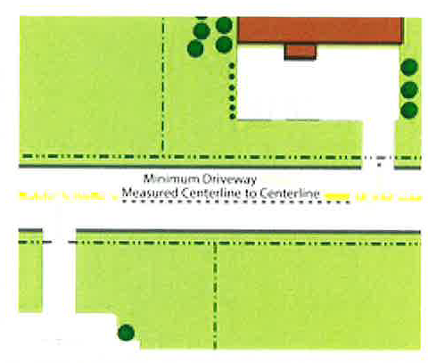
Driveway Spacing.
i.
Minimum spacing between two driveways, between a driveway and a street intersection, or between two street intersections, on the same side of the street, shall be 600 feet. The minimum spacing shall be measured from centerline to centerline for all driveways and street intersections.
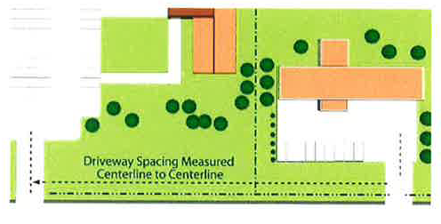
ii.
To reduce left-turn conflicts, new driveways shall be aligned with those across the street, where possible. If alignment is not possible, driveways shall be offset from those on the opposite side of the street by at least 200 feet, measured from centerline to centerline. The PLANNING COMMISSION may reduce this requirement, as provided in paragraph (d) below, where there is insufficient FRONTAGE and shared access with an adjacent site is not feasible. Greater offsets may be required depending on the expected inbound and outbound turn volumes to and from both driveways.
d.
Modification of Requirements.
i.
Modification to the spacing and other requirements above may be permitted by the PLANNING COMMISSION under the following conditions, provided the requirements of paragraph d(ii) are also satisfied.
(a)
The modification will allow an existing driveway to remain that does not meet the standards of this section but that has, or is expected to have, very low traffic volumes (less than 50 in- and out-bound trips per day) and is not expected to impact safe traffic operations.
(b)
The use is expected to generate a relatively high number of trips (exceeding 200/peak hour) and an additional driveway will improve overall traffic operations.
(c)
Practical difficulties exist on the site (sight distance limitations, existing DEVELOPMENT, soil conditions, the presence of CRITICAL AREAS, WATERBODIES, or WETLANDs, or unique site configuration) that make compliance unreasonable; or existing off-site driveways make it impractical to fully comply with the standards.
(d)
Because of restricted turning movements or the presence of a median that restricts turning movements, the driveway will not contribute to congestion or create an unsafe situation.
ii.
The PLANNING COMMISSION may waive or modify certain requirements of this section upon consideration of the following:
(a)
The proposed modification is consistent with the general intent of the standards of this section and the recommendations of the TOWN's COMPREHENSIVE PLAN.
(b)
Driveway geometrics have been improved to the extent practical to reduce impacts on traffic flow.
(c)
Shared access has been provided, or the applicant has demonstrated it is not practical.
(d)
Such modification is the minimum necessary to provide reasonable access, will not impair public safety, will not prevent the logical DEVELOPMENT or redevelopment of adjacent sites, and is not simply for convenience of the DEVELOPMENT.
e.
Driveways Permitted.
i.
In the case of a CORNER LOT or parcel, access shall only be provided from the intersecting street, not from Seabrook Island Road.
ii.
One (1) driveway may be permitted to serve an individual LOT or parcel; provided, the minimum spacing requirements of this section shall be maintained.
iii.
The use of shared driveways or access roads is encouraged.
iv.
One (1) additional driveway may be permitted for a property only as follows:
(a)
The PLANNING COMMISSION determines that, based on a TRAFFIC IMPACT ANALYSIS, the projected traffic volumes will warrant an additional access point and traffic operations will be improved along the road as a result; and
(b)
The minimum spacing requirements of this section will be met.
f.
Driveway Design.
i.
All driveways shall be designed according to the standards of the TOWN, including the provision of necessary turn radii, clear vision corners, drainage facilities, and utilities.
ii.
For high traffic generators or where high left-turn demand is expected, the PLANNING COMMISSION may require separate right- and left-turn egress lanes.
iii.
Where a boulevard entrance is proposed by the applicant or required by the PLANNING COMMISSION, a fully curbed island shall separate the ingress and egress lanes. The radii forming the edges on this island shall be designed to accommodate the largest vehicle that will use the driveway. The minimum area of the island shall be 180 square feet. For aesthetic purposes, the PLANNING COMMISSION may require landscaping, tolerant of street conditions, on the section outside the public right-of-way.
g.
Shared Driveways and Service Roads.
i.
Where the PLANNING COMMISSION determines that traffic operations and safety along the Seabrook Island Road corridor will be benefitted, a shared driveway or service road connecting two (2) or more properties or uses may be required.
ii.
A shared driveway or service road shall be within a recorded access EASEMENT. A draft of the access EASEMENT shall be provided to the TOWN for review prior to filing.
iii.
The number of access points along a service road shall be according to the standards of this section. The PLANNING COMMISSION may allow temporary access where the service road is not completed if a financial guarantee is provided which assures elimination of the temporary access upon completion of the service road. BUILDING permits shall not be issued until the financial guarantee has been submitted to the TOWN.
h.
Service Road Design Standards. Service roads shall generally be parallel to the front property line and may be located either in front of, adjacent to, or behind principal BUILDINGs. In considering the most appropriate alignment for a service road, the PLANNING COMMISSION shall consider the SETBACKs of existing and proposed BUILDINGs and anticipated traffic flow for the site. However, placement of the service road intersection with the driveway providing access to Seabrook Island Road shall be as far as possible from the street for safe and efficient operation. The separation distance between the nearest edge of the street and the nearest edge of a service road or drive aisle shall be equal to at least one-fifth of the LOT DEPTH, but no less than 60 feet.
i.
Access EASEMENT. The service road shall be within an access EASEMENT permitting traffic circulation between properties. This EASEMENT shall be 40 feet wide, except an access EASEMENT parallel to the PUBLIC STREET right-of-way may be 30 feet wide, if approved by the PLANNING COMMISSION. The required width shall remain free and clear of obstructions, unless otherwise approved.
ii.
Construction and materials. Service roads shall have a base, pavement, and gutter in accordance with TOWN standards for PUBLIC STREETs, except the service road shall have a minimum pavement width of at least 24 feet.
iii.
Parking. The service road is intended to be used exclusively for circulation, not as a parking or maneuvering aisle. The posting of "no parking" signs may be required along the service road. In reviewing the site plan, the PLANNING COMMISSION may permit temporary parking in the EASEMENT area where a continuous service road is not yet available; provided, the layout allows removal of the parking in the future to permit extension of the service road.
iv.
Access to service road. The PLANNING COMMISSION shall approve the location of all access points to the service road; provided, a minimum separation distance of 125 feet shall be maintained between driveways along the service road.
v.
MAINTENANCE. Each property owner shall be responsible for MAINTENANCE of the EASEMENT and service road.
i.
DOUBLE FRONTAGE Lots (Through Lots). LOTs which have DOUBLE FRONTAGE shall not be permitted, except where essential to provide separation of residential DEVELOPMENT from Seabrook Island Road. An EASEMENT of at least 10 feet in width, across which there shall be no right of access, shall be required along the lot lines abutting Seabrook Island Road. No right of access shall be granted except by the PLANNING COMMISSION.
5.
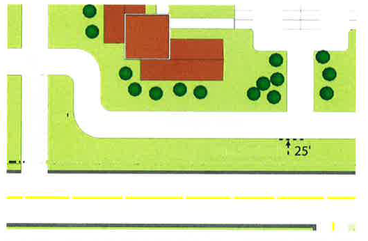
Landscaping. The area between any service road or driveway and the Seabrook Island Road right-of-way shall be planted as a level A BUFFER, as specified in Section 11.3.
6.
Signs. The SIGN requirements of Article 13 shall apply; provided, however, only one (1) monument SIGN shall be permitted per parcel and shall comply with the following requirements:
a.
Maximum area: 12 square feet
b.
Maximum height: six (6) feet
c.
Minimum SETBACK from road right-of-way: 10 feet
d.
External illumination only.
e.
Design, color, materials, and lettering shall conform to the standards adopted by the PLANNING COMMISSION for such signs.
7.
Lighting. Lighting shall meet the requirements of subsection 2.1 E.
8.
Non-motorized Connectivity. All properties subject to the Seabrook Island Road OVERLAY DISTRICT shall provide paved connections to existing pathways for pedestrians and cyclists.
D.
Traffic Impact Analysis.
1.
Applicability.
a.
TIA Required. Unless exempted, a TRAFFIC IMPACT ANALYSIS (TIA) shall be required for any DEVELOPMENT anticipated to generate more than 100 peak hour in-bound or out-bound trips, based on the most recent edition of the Trip Generation Manual published by the Institute of Transportation Engineers (ITE).
b.
Redevelopment. In the case of redevelopment, trip generation will be defined as the number of net new trips generated by the proposed use beyond the trips generated by the current or previous use, unless the previous use has been discontinued for more than 12 months.
c.
Other Circumstances. The review authority may waive the requirement to complete a TIA, or may require a TIA to be submitted for DEVELOPMENTs generating less than 100 peak hour directional trips, if deemed warranted based upon localized safety, operational, or street capacity issues, including levels of service (LOS) of existing roadways.
2.
Exemptions. Previously approved DEVELOPMENTs for which a TIA was submitted in conjunction with a preliminary PLAT for SUBDIVISION, final site plan, or mixed-use DEVELOPMENT shall be exempt from the requirements of this section; provided, the TIA is less than two (2) years old.
3.
Procedure. The TIA shall be submitted along with an application for a preliminary PLAT, preliminary SITE DEVELOPMENT PLAN review, or mixed-use concept plan. The TIA shall be prepared by a professional transportation engineer, licensed in the State of South Carolina, and shall, at a minimum:
a.
Estimate the traffic that will be generated as a result of the proposed DEVELOPMENT in addition to current (background) traffic volumes and proposed DEVELOPMENTs in the immediate vicinity. The ZONING ADMINISTRATOR, Charleston County, and/or SCDOT may also specify annual growth factors to be used in the TIA, as well as multipliers which may be reasonably necessary to account for seasonal variation in traffic volumes;
b.
Evaluate site access and internal circulation;
c.
Evaluate the ability of the surrounding road network to support the proposed DEVELOPMENT and the cumulative traffic of current (background) and other projected uses;
d.
Consider planned roadways or IMPROVEMENTs identified in relevant plans; and
e.
Identify specific IMPROVEMENTs to the surrounding road network that are necessary in order to support the traffic anticipated to be generated.
4.
TIA Submission for Projects with Cumulative Impacts. A TIA shall be required for DEVELOPMENT projects that do not otherwise meet the thresholds of a TIA if the application is for a project that:
a.
Shares features such as site access, common ownership, or other infrastructure with nearby undeveloped property for which future DEVELOPMENT can reasonably be anticipated; and
b.
The cumulative impact of the overall DEVELOPMENT can be expected to exceed the threshold for preparation of a TIA.
E.
Site Development Regulations.
1.
In addition to the requirements of this section, all DEVELOPMENT in the Seabrook Island Road OVERLAY DISTRICT shall meet the applicable requirements as listed elsewhere in this ordinance:
a.
General Provisions—Article 2
b.
CONDITIONAL USE Requirements—Article 9
c.
Environmental Performance Standards—Article 10
d.
Trees, Landscaping and BUFFERing—Article 11
e.
Parking and Loading—Article 12
f.
Signs—Article 13
g.
Site Plan Review—Article 14
(Ord. No. 2024-06, § 2, 12-17-2024)
Section 8.2 - SHORT-TERM RENTAL overlay district
A.
Purpose. The purpose of the SHORT-TERM RENTAL OVERLAY DISTRICT is to relax certain restrictions related to SHORT-TERM RENTAL UNITs operating in areas having a disproportionately high concentration of rental properties, a disproportionately low concentration of owner-occupied residences, and a history of tourism-related activities, compared to other residential areas of the TOWN. Areas within the SHORT-TERM RENTAL OVERLAY DISTRICT will generally feature higher residential densities, greater variation in USE types, and close proximity to community amenities, including beaches and recreational facilities. Outside of the SHORT-TERM RENTAL OVERLAY DISTRICT, the TOWN seeks to preserve the residential character of SINGLE-FAMILY neighborhoods by further limiting the number of SHORT-TERM RENTAL UNITS permitted to operate. It is intended that the provisions of this section shall be further implemented in concert with the CONDITIONAL USE requirements for SHORT-TERM RENTAL UNITs, as set forth in subsection 9.4 O.
B.
Applicability.
1.
A SHORT-TERM RENTAL OVERLAY DISTRICT is hereby established. The boundaries of the SHORT-TERM RENTAL OVERLAY DISTRICT shall be as illustrated on the official ZONING MAP referenced in Section 3.2, and shall apply to all the following:
a.
All LOTS or parcels of land within the TOWN which are zoned as follows:
i.
R-MF MULTI-FAMILY;
ii.
R-TH TOWNHOME; and
iii.
R-CL SINGLE-FAMILY Cluster.
b.
All LOTS or parcels of land within the TOWN which are zoned R-SF3 Small LOT SINGLE-FAMILY and located on the following streets:
i.
Oyster Catcher Court; and
ii.
Rolling Dune Road.
c.
All LOTS or parcels of land within the TOWN which are zoned R-SF2 Medium LOT SINGLE-FAMILY and located on the following streets:
i.
Amberjack Court;
ii.
Beach Court;
iii.
Beachcomber Run;
iv.
Bonita Court;
v.
Catesbys Bluff;
vi.
Cobia Court;
vii.
Loggerhead Court;
viii.
Oyster Catcher Court;
ix.
Pompano Court;
x.
Rolling Dune Road;
xi.
Seabrook Island Road (#3500 through #3773 only);
xii.
Sealoft Drive;
xiii.
Seascape Court; and
xiv.
Seaview Drive.
2.
Any LOT or parcel of land which is annexed or rezoned after the effective date of this ordinance shall become subject to the SHORT-TERM RENTAL OVERLAY DISTRICT if the LOT or parcel of land meets any one or more of the provisions set forth in paragraph (1) of this subsection.
3.
The requirements of this section are in addition to, and shall supplement, those imposed on the same lands by any underlying zoning provisions of this ordinance or other ordinances of the TOWN. To the extent a conflict exists, these regulations shall supersede all conflicting regulations, unless otherwise specified.
C.
District Requirements.
1.
PERMITTED and CONDITIONAL USEs.
a.
All PERMITTED and CONDITIONAL USEs allowed within the underlying zoning district shall be permitted within the SHORT-TERM RENTAL OVERLAY DISTRICT, subject to the applicable requirements of the underlying district, unless superseded by this section.
b.
SHORT-TERM RENTAL UNITs shall be allowed as a CONDITIONAL USE within the SHORT-TERM RENTAL OVERLAY DISTRICT, subject to the conditions set forth in subsection 9.4 O, including, without limitation, the SHORT-TERM RENTAL permit caps imposed pursuant to subsection 9.4 O(3)(a)(ix).
2.
Spatial Requirements. Except as otherwise specified, the spatial requirements of the underlying zoning district shall control.
D.
Site Development Regulations.
1.
In addition to the requirements of this section, all DEVELOPMENT in the SHORT-TERM RENTAL OVERLAY DISTRICT shall meet the applicable requirements as listed elsewhere in this ordinance:
a.
General Provisions—Article 2
b.
CONDITIONAL USE Requirements—Article 9
c.
Environmental Performance Standards—Article 10
d.
Trees, Landscaping and BUFFERing—Article 11
e.
Parking and Loading—Article 12
f.
Signs—Article 13
g.
Site Plan Review—Article 14
(Ord. No. 2024-06, § 2, 12-17-2024)