
Seabrook Island City Zoning Code
ARTICLE 5
RESIDENTIAL DISTRICTS
Section 5.1 - Purpose.
The purposes of the residential districts, in general, are to: Provide for quiet, low-density residential neighborhoods; discourage unwarranted encroachment by regulating commercial and other uses which would interfere with the development or continuation of residential uses; minimize nonconformities; and discourage uses which would generate traffic on minor streets other than required to serve residences on those streets.
A.
R-SF1, Large LOT SINGLE-FAMILY. This district is created to retain the character of established large-LOT SINGLE-FAMILY neighborhoods and to provide a district that would allow for the creation of future estate-sized home sites. Other uses are also permitted that are compatible with and supportive of the character of the homes in this district.
B.
R-SF2, Moderate LOT SINGLE-FAMILY. It is the purpose of this district to encompass those early SUBDIVISIONs that were developed prior to the incorporation of the TOWN and to establish DEVELOPMENT standards based on the existing moderate density conditions that will minimize nonconformities to the extent practical. Other uses are also permitted that are compatible with, and supportive of, the character of the homes in this district.
C.
R-SF3, Small LOT SINGLE-FAMILY. This district is intended to support established DEVELOPMENT patterns of those existing SUBDIVISIONs containing SINGLE-FAMILY homes on small LOTs and to reduce existing nonconformities to the extent practical.
D.
R-CL, SINGLE-FAMILY Cluster. This district is intended to accommodate SINGLE-FAMILY detached dwellings which are situated in a "cluster" style arrangement within a PLANNED COMMUNITY, rather than on traditional SINGLE-FAMILY LOTs, and to provide greater flexibility for their IMPROVEMENT and expansion.
E.
R-TH, TOWNHOME. This district is established specifically to accommodate TOWNHOME DEVELOPMENT at a reasonable density to afford an alternate form of residence within the community.
F.
R-MF, MULTI-FAMILY. This district is intended to support MULTI-FAMILY dwellings, including CONDOMINIUMs and apartments, at moderate density as another residential option within the community.
Section 5.2 - Schedule of Uses.
BUILDINGs or land shall not be used; and BUILDINGs shall not be erected, except for the following specified uses, unless otherwise provided for in this ordinance. Land and/or BUILDINGs in the districts indicated at the top of Table 5-2 may be used for the purposes denoted by the following abbreviations:
A.
PERMITTED USE (P). Land and/or BUILDINGs in this district may be used by right.
B.
CONDITIONAL USE (C). Land and/or BUILDINGs in this district may be used by right, provided the specific conditions related to that use, as found in Article 9, are met.
C.
Specific Conditions. Indicates the relevant section outlining the specific requirements or conditions applicable to the CONDITIONAL USE which must be satisfied, in addition to the general criteria of Section 9.3.
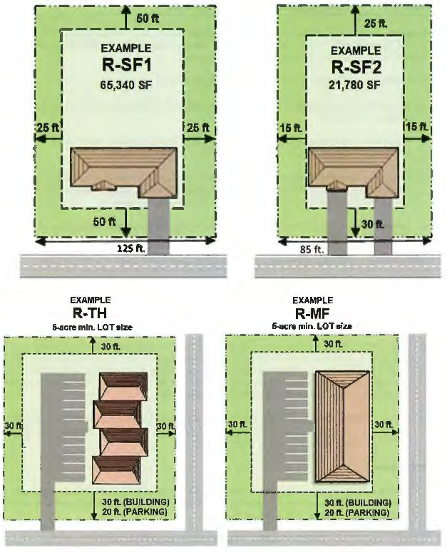
Section 5.3 - Spatial Requirements.
A.
Area and Width. All LOTs and BUILDINGs shall meet the minimum area and width requirements of Table 5-3 based on the date on which they were recorded.
B.
SETBACKs and Related Standards. All STRUCTUREs and their placement on a LOT recorded prior to the adoption of this ordinance shall conform to the minimum dimensional requirements listed in Table 5-3a. STRUCTUREs erected on new LOTs, recorded on or after the adoption of this ordinance, shall conform with the requirements of Table 5-3b.
11 Minimum LIVABLE FLOOR AREA requirements are for single family detached dwellings in the R-SF1, R-SF2, and R-SF3 districts. The minimum required LIVABLE FLOOR AREA for units in the R-CL, R-TH and R-MF districts shall be determined by the number of bedrooms, as follows: efficiency unit - 650, 1 bedroom - 800, 2 bedroom - 1,000, 3 bedroom - 1,200. An additional 100 square feet shall be provided for each bedroom over 3.
12 Average established setback shall apply, as applicable, in R-SF1, R-SF2, and R-SF3 Districts, per Section 5.3 C.
13 For lots with less than 13,500 square feet of HIGH GROUND, the minimum SIDE YARD SETBACK shall be 10 feet. For lots with greater than 13,500 square feet, but less than 17,500 square feet, of HIGH GROUND, the minimum SIDE YARD SETBACK shall be 12.5 feet.
14 Where a LOT zoned R-SF3 fronts two (2) intersecting streets wherein one (1) street contains a CUL-DE-SAC, the required FRONT YARD SETBACK from the street containing the CUL-DE-SAC shall be 30 feet, and the required FRONT YARD SETBACK from the street which does not contain the CUL-DE-SAC shall be 20 feet.
15 In instances where an existing structure on a neighboring lot is situated less than seven and one-half (7.5) feet from the shared property line in the R-SF3 district, a larger SIDE YARD SETBACK shall be required in order to ensure a minimum separation of at least 15 feet between structures. In the R-CL, R-TH and R-MF districts, no minimum SIDE YARD shall be required; provided, a minimum separation distance of 15 feet shall be maintained between all buildings.
16 Front setbacks shall only apply along perimeter streets, not including interior streets within a DEVELOPMENT.
17 No REAR YARD shall be required; provided, a minimum SETBACK of 20 feet shall be required from the DEVELOPMENT's perimeter property boundary.
18 No minimum SIDE YARD shall be required; provided, a minimum separation distance of 25 feet shall be maintained between all buildings.
19 No REAR YARD shall be required; provided, a minimum setback of 30 feet shall be required from the development's perimeter property boundary.
Section 5.4 - CONSERVATION SUBDIVISIONS.
A.
Purpose. The purpose of this section is to encourage the voluntary preservation of OPEN SPACE by permitting limited design flexibility for new residential DEVELOPMENT within designated zoning districts. This section is intended to:
1.
Provide for the permanent preservation of OPEN SPACE;
2.
Permit flexibility of design in order to promote environmentally sensitive design and the efficient use of land;
3.
Preserve unique or sensitive natural resources such as groundwater, floodplains, WETLANDS, streams, steep slopes, woodlands, and wildlife habitats;
4.
Permit the clustering of dwellings and accessory structures, at densities consistent with neighboring DEVELOPMENT, to reduce the amount of infrastructure, including paved surfaces and utility easements, necessary for residential development;
5.
Reduce erosion and sedimentation by minimizing land disturbance and removal of vegetation in residential development; and
6.
Conserve scenic views and reduce perceived density.
B.
General Requirements.
1.
Applicability. The CONSERVATION SUBDIVISION is an available option, though not a requirement, for new residential DEVELOPMENT within the R-SF1 zoning district.
2.
Size and ownership requirements. Any property which is proposed to be subdivided as a CONSERVATION SUBDIVISION must contain a minimum of 10 contiguous acres of HIGH GROUND. The land may be held in single and separate ownership or in multiple ownership. If held in multiple ownership, the site shall be developed according to a single plan with common authority and common responsibility.
3.
Minimum OPEN SPACE required. To qualify as a CONSERVATION SUBDIVISION, at least 25 percent of the developable HIGH GROUND shall be preserved as OPEN SPACE pursuant to the provisions of this section.
C.
Procedures.
1.
Review and approval. All requests to develop a CONSERVATION SUBDIVISION shall be reviewed and approved by the Planning Commission, pursuant to the requirements of this section and those specified in Article 15.
2.
Plan required. Any PERSON seeking to subdivide property as a CONSERVATION SUBDIVISION shall prepare and submit an OPEN SPACE plan concurrent with the application for a preliminary PLAT. The OPEN SPACE plan shall include the following:
a.
Dedicated OPEN SPACE shall be shown on the preliminary PLAT and shall be labeled to specify that the land is to be permanently dedicated as OPEN SPACE. For purposes of this section, credit shall be granted only for developable HIGH GROUND which is dedicated as OPEN SPACE.
b.
As a condition of approval, the applicant shall specify how the dedicated OPEN SPACE shall be conveyed. The conveyance may be trough any of the following means, subject to approval by the PLANNING COMMISSION:
i.
Deeded in perpetuity to the TOWN, subject to prior approval by TOWN COUNCIL;
ii.
Reserved for common use or ownership of all property owners within the DEVELOPMENT by covenants in the deeds approved by the TOWN attorney. A final copy of the proposed covenants shall be submitted with the application for final PLAT approval;
iii.
Deeded in perpetuity to a private, non-profit, tax-exempt organization legally constituted for conservation purposes under terms and conditions that ensure the perpetual protection and management of the property for conservation purposes. A copy of the proposed deed and relevant corporate documents of the land trust shall be submitted with the application for final PLAT approval;
iv.
Deeded to a property owner's association or REGIME within the DEVELOPMENT upon terms and conditions approved by the TOWN attorney that will ensure the continued use and management of the land for the intended purposes. If this option is selected, the formation and incorporation by the applicant of one (1) or more appropriate property owners' associations or REGIMEs shall be required prior to approval. A copy of the proposed property owner's deed and the by-laws and other relevant documents of the property owner's association or REGIME shall be submitted with the application for final PLAT approval. The following shall be required if OPEN SPACE is to be dedicated to a property owners' association or REGIME:
(a)
Covenants providing for mandatory membership in the association/REGIME and setting forth the owner's rights, interests, and privileges in the association and the common land, must be included in the deed for each LOT or unit;
(b)
The property owners' association or REGIME shall have the responsibility of maintaining the OPEN SPACE and shall operate and maintain any recreational facilities which may be provided within the OPEN SPACE;
(c)
The association or REGIME shall have the authority to levy charges against all property owners to defray the expenses connected with the operation and MAINTENANCE of OPEN SPACE and recreational facilities; and
(d)
The applicant shall maintain control of dedicated OPEN SPACE and be responsible for its MAINTENANCE until DEVELOPMENT sufficient to support the association or REGIME has taken place.
3.
OPEN SPACE to be dedicated to the TOWN shall have shape, dimension, character, location, and topography to ensure appropriate access and usability, and to accomplish at least two (2) of the following OPEN SPACE purposes:
a.
Natural resource conservation,
b.
WETLAND and water course conservation,
c.
Selective forestry,
d.
Wildlife habitat,
e.
Recreation,
f.
Civic purposes, or
g.
Scenic preservation.
4.
Dedicated OPEN SPACE features that are not dedicated to the TOWN may be open to the public or restricted to the residents or property owners within the DEVELOPMENT.
5.
All approved OPEN SPACE shall be dedicated in accordance with the provisions of this section, and as approved by PLANNING COMMISSION, prior to commencing any construction, regardless of whether or not the project will be completed in phases.
D.
Spatial Requirements for CONSERVATION SUBDIVISIONS.
1.
Standards. The following spatial requirements shall apply to all LOTs created on or after July 1, 2022, within a duly authorized CONSERVATION SUBDIVISION:
2.
Other requirements. Except for those modifications expressly authorized herein, the applicant shall comply with all other provisions of this ordinance, including, specifically, all other requirements of Tables 5-3 and 5-3b, and all other applicable laws and regulations, except those which are incompatible with the provisions contained herein.
Section 5.5 - Site Development Regulations.
In addition to the requirements of this article, all DEVELOPMENT in the Residential Districts shall meet the applicable requirements as listed elsewhere in this ordinance:
A.
General Provisions - Article 2.
B.
CONDITIONAL USE Requirements - Article 9.
C.
Environmental Performance Standards - Article 10.
D.
Trees, Landscaping and BUFFERing - Article 11.
E.
Parking and Loading - Article 12.
F.
Signs - Article 13.
G.
Site Plan Review - Article 14.