
Seabrook Island City Zoning Code
APPENDIX A
DEFINITIONS
A
Accessory Building. A BUILDING or STRUCTURE customarily incidental and subordinate to and detached from the PRINCIPAL BUILDING and located on the same LOT with such PRINCIPAL USE, uses, or BUILDING.
Accessory Dwelling. An attached or detached dwelling on the same LOT or parcel as a principal dwelling, subordinate to and independent of the principal dwelling.
Acreage, Gross. All land under single title or ownership and recorded with the property deed and consisting of contiguous acreage, including submerged lands and WETLANDs.
Acreage, Net. The total area of HIGH GROUND on a given LOT or group of LOTs, including areas for proposed public and private roads.
Act of God. An overwhelming natural event, often unpredictable or difficult to anticipate, that is uncontrolled and uninfluenced by the power of man and that could not be prevented or avoided by foresight or prudence. Examples of such events include FLOODs, hurricanes, and tropical storms.
Antenna. A device, dish, or array used to transmit or receive telecommunications signals.
B
Beach Trust. All lands located between the beach front property lines of any oceanfront LOT and the high-water mark of the Atlantic Ocean and North Edisto River, directly in front of each such LOT.
Berm. An earthen mound formed to shield undesirable views, decrease noise, or add topographical interest.
Buffer. OPEN SPACEs, landscaped areas, FENCEs, walls, BERMs, or any combination used to physically separate or screen one (1) use or property from another or to separate a water course from DEVELOPMENT.
Building. Any STRUCTURE having a roof supported by columns or walls and which is designed for shelter, storage, or enclosure of PERSONs, animals, or property of any kind.
Building Alteration. Any addition to or reduction of a BUILDING, or any relocation of a BUILDING.
Building Codes. The most recent editions of the building, electrical, gas, mechanical, plumbing, fire prevention, and energy conservation codes adopted by the South Carolina Building Codes Council and enforced by the Charleston County Building Inspection Services Department.
Building Height. The vertical distance measured from the DESIGN FLOOD ELEVATION, or ground level if the structure is not in a SPECIAL FLOOD HAZARD AREA, to the highest point of the roof.
Building Line (See: "SETBACK, Required").
Building Official. The person designated by the TOWN to administer the BUILDING CODES.
Business Center. Any two (2) or more businesses which:
1.
Are located on a single LOT or parcel of property, share parking and access, and function as an integral unit; or
2.
Are connected by common walls, partitions, canopies, or other structural members to form a continuous BUILDING or group of BUILDINGs; or
3.
Otherwise function and present the appearance of a single, contiguous business area.
C
Cluster Units. A form of residential DEVELOPMENT that permits housing units to be grouped on sites or LOTs with dimensions, FRONTAGEs, and SETBACKs reduced from conventional sizes; provided, the density of the tract as a whole does not exceed the density allowed by the district under existing regulations and the remaining land area is devoted to common OPEN SPACE.
Communications Tower. A tower, pole or similar STRUCTURE which supports a telecommunications ANTENNA above ground in a fixed location, free-standing, or on a BUILDING STRUCTURE.
Comprehensive Plan. The plan for future land use and DEVELOPMENT of the TOWN which is prepared for, and adopted by, the TOWN COUNCIL, pursuant to the requirements of the South Carolina Local Government Comprehensive Planning Act of 1994.
Conditional Use. A use other than a PERMITTED USE in a zoning district, administratively permitted subject to compliance with added conditions specified within this ordinance for that specific use.
Condominium. A type of DEVELOPMENT in which the dwellings, offices, floor area, etc. are owned individually and the STRUCTURE, common area, and joint facilities are owned collectively by all individual owners on a proportional and undivided basis. In the case of a MULTI-FAMILY residential CONDOMINIUM dwelling, ownership does not extend beyond the interior face of the exterior walls; for a SINGLE-FAMILY detached CONDOMINIUM dwelling, ownership does not extend beyond the drip-line of the roof; or some combination of the two (2) in the case of a TOWNHOME CONDOMINIUM dwelling.
Conservation Subdivision. A type of SUBDIVISION where lots are clustered in specific areas to allow the remaining land to be preserved for OPEN SPACE purposes.
Council. The elected TOWN COUNCIL of the TOWN of Seabrook Island.
Critical Area. Tidelands, coastal waters, WETLANDs, marshes, and the beach/sand dunes systems determined by SCDHEC-OCRM.
Critical Line. A delineation of CRITICAL AREA boundaries determined by SCDHEC-OCRM.
Crown Spread. The average length of two (2) lines across the crown area of a tree. The first measurement is made along the longest axis of the crown from one (1) edge to the opposite edge. A second measurement is taken perpendicular to the first line through the central mass of the crown. The two (2) values are averaged to calculate crown spread.
Cul-de-Sac. A LOCAL STREET with a single common ingress and egress and with a circular turnaround or similar configuration at the end.
D
DBH (Diameter at Breast Height). A standard method of measuring the size of a tree taken at 4.5 feet above the ground.
Deck. An open and uncovered horizontal surface, attached to and accessible from the principal STRUCTURE, which is constructed so rain can pass directly through it to the ground beneath. A DECK having a roof or other permanent covering of any kind is considered a PORCH.
Density, Gross. The number of DWELLING UNITs or residential LOTs per gross acre of land.
Density, Net. The number of DWELLING UNITs or residential LOTs per net acre of land.
Development. Any manmade change to improved or unimproved real estate, including but not limited to: SUBDIVISION of land; construction or alteration of STRUCTUREs, roads, utilities, and other facilities; installation of septic systems; mining, dredging, grading, paving, excavation, or drilling operations; deposit of refuse, debris, or fill materials; and clearing of natural vegetative cover. The following do not constitute DEVELOPMENT within the meaning of this ordinance: agricultural uses; transfer of title, leases, and EASEMENTs; or MAINTENANCE as defined in this article.
Dwelling Unit. A BUILDING or portion of a BUILDING designed and occupied exclusively for residential purposes by a FAMILY, having permanent provisions for living, sleeping, eating, cooking, and sanitation. A recreation vehicle, vehicle chassis, tent, or other transient sleeping accommodation is not considered a dwelling.
1.
Dwelling, Multi-Family. A BUILDING, or portion thereof, designed to be occupied by three (3) or more families, living independently of each other and each doing their own cooking within their DWELLING UNIT; with the number of families in residence not exceeding the number of DWELLING UNITs provided.
2.
Dwelling, Single-Family, Detached. A free-standing dwelling, other than a MOBILE HOME, designed to be occupied by one (1) FAMILY.
3.
Dwelling, Two-Family. A detached BUILDING designed to be occupied by two (2) families living independently of one another and each doing their own cooking within their own dwelling, also referred to as a duplex.
4.
Dwelling, Townhome. A dwelling designed for occupancy by one (1) FAMILY in a row of at least three (3) DWELLING UNITs in which each unit has its own front and rear access to the outside, no unit is located over another, and each unit is separated from any other unit by one (1) or more vertical common fire-resistant walls. This dwelling type may also be referred to as attached SINGLE-FAMILY or rowhouses.
E
Easement. A grant of one (1) or more property rights by the property owner to and/or for the use by the public, a corporation, or another PERSON or entity.
Erosion. The wearing away of land surface by the action of wind, water, gravity, or any combination of those forces.
F
Family. An individual or group of two (2) or more individuals related by blood, adoption, or marriage, living and cooking together as a single housekeeping unit, exclusive of in-home service providers. The term family shall also include a group of no more than two (2) unrelated individuals living and cooking together as a single housekeeping unit.
Fence. An artificially constructed barrier, typically constructed of posts, wire, wood and/or metal, erected to enclose, screen, or separate areas.
Flood. A general and temporary condition of partial or complete inundation of normally dry land areas from the unusual and rapid accumulation of runoff or surface waters from any source.
Flood Elevation, Base (BFE). The elevation of surface water resulting from a FLOOD that has a 1% chance of equaling or exceeding that level in any given year. The BFE is determined by the Federal Emergency Management Administration (FEMA) and shown on the Flood Insurance Rate Map (FIRM) for zones AE, AH, A1-A30, AR, AR/A, AR/AE, AR/A1-A30, AR/AH, AR/AO, V1-V30 and VE.
Flood Elevation, Design (DFE). The minimum elevation required for structures within a SPECIAL FLOOD HAZARD AREA (SFHA). The DFE shall be the combination of the mandatory BASE FLOOD ELEVATION (BFE) plus the required FREEBOARD.
Flood Elevation, Alternate Design. An optional elevation, as specified in Section 2.5 C, allowed for structures for which a permit was issued on or after January 29, 2021, within a SPECIAL FLOOD HAZARD Area. This consists of the FEMA BASE FLOOD ELEVATION (BFE) in effect as of January 28, 2021, plus the required 2-foot FREEBOARD.
Flood Hazard Area, Special (SFHA). That area designated by the Federal Emergency Management Administration (FEMA) on the Flood Insurance Rate Map (FIRM) as being subject to inundation by a flood event having a 1-percent chance of being equaled or exceeded in any given year. The 1-percent annual chance flood is also referred to as the base flood or 100-year flood. SFHAs are labeled as Zone A, Zone AO, Zone AH, Zones A1-A30, Zone AE, Zone A99, Zone AR, Zone AR/AE, Zone AR/AO, Zone AR/A1-A30, Zone AR/A, Zone V, Zone VE, and Zones V1-V30. Moderate flood hazard areas, labeled Zone B or Zone X (shaded) are also shown on the FIRM, and are the areas between the limits of the base flood and the 0.2-percent-annual-chance (or 500-year) flood. The areas of minimal flood hazard, which are the areas outside the SFHA and higher than the elevation of the 0.2-percent-annual-chance flood, are labeled Zone C or Zone X (unshaded).
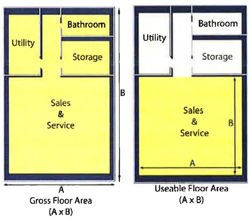
Floor Area, Gross. The total horizontal area of all floors of a BUILDING, including mezzanines, measured from the interior faces of the exterior walls of a BUILDING.
Floor Area, Livable. The total area of all floors within a DWELLING UNIT whose height is more than half above the FINISHED GRADE, having a minimum floor-to-ceiling height of seven and one-half (7½) feet, located on a permanent foundation, wired for electrical service, conditioned, and fully enclosed for year-round use. This term shall not include GARAGEs.
Floor Area, Usable. The actual occupied area not including unoccupied accessory areas such as corridors, stairways, bathrooms, storage rooms, mechanical/utility rooms, and closets.
Freeboard. An additional elevation, expressed in feet above the mandatory BASE FLOOD ELEVATION (BFE), which is required for the purposes of public safety and flood plain management. The required Freeboard shall be as established by the Charleston County Flood Damage Prevention and Protection Ordinance, which was adopted by reference pursuant to Section 20-22 of the Town Code.
Frontage. The distance between the side lot lines measured at the street right-of-way line.
G
Garage. An attached or detached enclosed STRUCTURE, on a LOT or in a MULTI-FAMILY DEVELOPMENT, devoted to or designed for the storage of vehicles.
Grade, Finished. The final elevation and contour of the ground after cutting or filling and conforming to the proposed design.
Grade, Natural. The elevation of the ground level in its natural state before construction, filling, or excavation.
H
High Ground. That portion of a LOT or tract of land exclusive of naturally occurring water bodies and any areas lying below the SCDHEC-OCRM CRITICAL LINE or any areas within the jurisdiction of the U.S. Army Corps of Engineers as shown on a PLAT or site plan that has been stamped by SCDHEC-OCRM, the U.S. Army Corps of Engineers, or both.
Home Occupation. An occupation, profession, or trade customarily and commonly carried out by an occupant in a DWELLING UNIT as an ACCESSORY USE which is clearly incidental and subordinate to the principal RESIDENTIAL USE.
Homeowner's Association. A legal entity organized to manage and maintain a horizontal property REGIME or PLANNED COMMUNITY.
Hotel. A BUILDING or collection of BUILDINGS under single management, operated for profit, which provides rooms or suites intended primarily as sleeping accommodations for the general public to rent on a daily basis for registered guests. A HOTEL includes a central interior lobby and provides daily room cleaning and linen changes. Other supportive facilities may also include, but not be limited to, meeting rooms, incidental RETAIL sales, RESTAURANTs, lounges, swimming pools, recreational and fitness facilities, and similar facilities/services intended principally to serve registered guests.
I
Improvement. The construction, reconstruction, or alteration of any BUILDING or STRUCTURE, but not including normal MAINTENANCE, and the establishment of basic services and amenities associated with a DEVELOPMENT activity including, but not limited to, streets and sidewalks, parking areas, landscaping, water and sewer systems, drainage systems, property markers and monuments, and recreation facilities, (e.g., lakes, swimming pools, tennis courts, golf courses, riding stables, clubhouses, cabanas, MARINAs, docks).
Impervious Surface. Any material which substantially reduces or prevents absorption of stormwater into the earth.
J
Reserved.
K
Kennel. A BUILDING or other premise on which three (3) or more dogs, cats, or other household pets, four (4) months of age or older, are boarded, bred, or sold for commercial purposes.
L
Land Disturbing Activities. Any activity involving the clearing, cutting, excavating, filling, or grading of land or other activity that alters land topography or vegetative cover.
Livestock. Domesticated animals, including but not limited to cattle, pigs, sheep, goats, chickens, and llamas, raised in an agricultural setting to produce commodities such as meat, eggs, milk, fur, leather, and wool.
Loading Space, Off-Street. An area of prescribed size meeting the requirements of this ordinance and reserved for pick-up and delivery vehicles serving the use on a LOT.
Lot. A parcel of land defined by a legally approved and recorded SUBDIVISION PLAT or metes and bounds description that has been recorded in the office of the county register of deeds. "LOT" includes the term "plot."
Lot Area. The total horizontal area within the LOT lines of the LOT, excluding any street right-of-way or EASEMENT dedicated for street purposes.
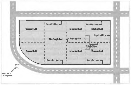
Lot, Corner. A LOT with at least two (2) contiguous sides abutting the intersection of two streets, forming an interior angle of less than 135 degrees. Also, a LOT abutting a curved street shall be considered a CORNER LOT if the tangents of the curve, at the points of beginning with the LOT or the points of intersection of the side lot lines with the street line, meet at an interior angle of less than 135 degrees.
Lot Coverage. The percent area of a LOT covered by STRUCTURE(s), as determined by the footprint of all STRUCTUREs, and impermeable surfaces such as, but not limited to paved parking areas, driveways, and PATIOs.
Lot, Depth. The horizontal distance between the front and rear lot lines of interior and CORNER LOTs, or between the front lines of a THROUGH LOT, measured along the median line between the side lot lines.
Lot, Double Frontage (also termed a Through Lot). A lot having FRONTAGE on two (2) more or less parallel streets, as distinguished from a CORNER LOT. A CORNER LOT shall be considered having double FRONTAGE if it has access on three (3) or more sides.
Lot, Interior. A LOT other than a corner or THROUGH LOT.
Lot Width. The horizontal distance between side lot lines measured at the two (2) points where the required front SETBACK line intersects the side lot lines.
M
Maintenance. Activities required or undertaken to conserve as nearly, and for as long as possible, the original condition of a BUILDING or property while compensating for normal wear and tear. Examples include, but are not limited to, painting, window/door replacement, reroofing, siding replacement, interior remodeling, and similar activities.
Map, Zoning. The official ZONING MAP of the TOWN, bearing the seal of the TOWN together with the signature of the Mayor, as well as the date of adoption of the map by TOWN COUNCIL.
Marina. A dock or basin providing secure moorings for pleasure boats and often offering ancillary services such as supplies, fuel, and/or REPAIR facilities.
Mean Sea Level. The Nations Geodetic Vertical Datum (NGVD) of 1929, North American Vertical Datum (NAVD) of 1988, or other datum, to which the BASE FLOOD ELEVATIONS shown on a community's Flood Insurance Rate Maps (FIRM) are shown.
Mobile Home or Housing Unit. A detached SINGLE-FAMILY DWELLING UNIT designed to be transported after fabrication on its own wheels; arriving at the site where it is to be occupied as a dwelling complete and ready for occupancy, except for minor and incidental unpacking and assembly operations, connection to utilities, and the like. This term shall not include travel trailers, shipping containers, or similar STRUCTUREs not designed or intended for permanent occupancy.
N
Nonconforming. A term applied to LOTs, STRUCTUREs, and uses of land which were lawful before the adoption of this ordinance or subsequent amendment but which, as a result of such adoption, are prohibited or no longer comply with the requirements of this ordinance.
O
Open Air Recreation. Public or private lands and/or facilities devoted to the enjoyment of outdoor leisure activities, such as: swimming pools, fishing, beaches, boat ramps, docks, piers, lifeguard stations, boardwalks, athletic fields and courts, and natural preserves.
Open Space. Any parcel or area of land or water essentially unimproved and set aside, dedicated, designated, or reserved for public or private use or enjoyment. Open space does not include streets, drives, off-street parking and loading areas, and manmade stormwater detention or retention basins, except as ancillary to the open space use.
Overlay District. A district that applies supplementary regulations to land which is classified into a specific underlying area or district.
P
Parking Lot. Any public or private open-air area designed and used for the express purpose of parking motor vehicles on a temporary basis in conformance with the requirements of this ordinance.
Parking Space—Off Street. A defined space on a parcel of property or individual LOT within which a motor vehicle is parked, exclusive of driveways and access aisles.
Patio. A hard surfaced (including permeable pavers), unroofed area on the same LOT as a principal dwelling intended for outdoor seating, entertainment, and similar activities.
Performance Guarantee. A bond, letter of credit, cash deposit, or similar financial instrument deposited with the TOWN or other public authority by a developer or property owner to help ensure that all required site IMPROVEMENTs are completed in a timely manner, in accordance with approved PLATs and construction plans.
Permitted Use. A use of property specifically allowed within a zoning district wherever that district exists in the TOWN; provided, all dimensional and other requirements applicable to that district are satisfied.
Person. Any individual, firm, partnership, association, social or fraternal organization, corporation, trust, estate, receiver, syndicate, branch of government, legal entity, or any combination acting as for himself, herself, or itself or as the servant, employee, agent, or representative of another.
Personal Service Establishment. Any business primarily engaged in the provision of frequent or recurrent needed services for an individual. Examples include, without limitation: beauty and barbershops, shoe REPAIR shops, watch REPAIR, and tailor shops.
Pervious Surface. Any material which allows rainfall to percolate through it rather than running off. A pervious surface may utilize porous asphalt, pervious concrete, brick or concrete pavers interlaid in a running bond pattern, or similar systems approved by the ZONING ADMINISTRATOR.
Place of Public Worship. A BUILDING or STRUCTURE, or groups of BUILDINGs or STRUCTUREs which, by design and construction, are primarily intended for conducting organized religious services and associated ACCESSORY USEs that are noncommercial in nature.
Planned Community. A tract of land master planned and developed in projects or phases, which may consist of one (1) or more different land uses and/or residential densities.
Planning Commission. The TOWN of Seabrook Island PLANNING COMMISSION.
Plat. A map or drawing upon which is depicted the layout of a SUBDIVISION for approval.
Porch, Enclosed. An unheated or conditioned, roofed STRUCTURE with walls whose surface area is at least 50 percent glass or screen, attached to or a part of a BUILDING, and which is directly accessible to and from the BUILDING.
Porch, Unenclosed. A roofed STRUCTURE without walls, attached to or part of a BUILDING, and which is directly accessible to and from the BUILDING. The term "unenclosed PORCH" shall include any veranda, terrace, portico, or similar projection from a main wall of a BUILDING and covered by a permanent covering of any kind.
Primary Dune. The dune or dunes that constitute the front row of dunes adjacent to the Atlantic Ocean.
Principal Use. The main or primary use to which land or a STRUCTURE is devoted.
Q
Reserved
R
Recreational Vehicle. Vehicles or equipment used primarily for recreational purposes, including but not limited to, motor homes, travel trailers, camper trailers, pop-up campers, boats, motorcycles, dune buggies, similar vehicles, and trailers used to transport them.
Regime, Horizontal Property. A form of CONDOMINIUM ownership providing for individual ownership of a particular apartment in a building and the common right to a share, with other co-owners, in the general and limited common elements of the property.
Repair. An activity required to fix or mend something that is damaged, defective, or broken restoring it to its original condition, but not expanding or altering its original function or purpose.
Replace. An activity in which something that is damaged, defective, broken, obsolete, or otherwise no longer desired is removed, in whole or in part, and a similar item, serving the same function or purpose, is substituted in its place.
Restaurant. A BUILDING or part of a BUILDING where food is prepared and served primarily for consumption on the premises and more than half the revenue is obtained from the sale of food.
Restaurant, Drive-Through. A RESTAURANT whose method of operation includes the delivery of prepared food to the customer in a motor vehicle, typically though a drive-through window, for consumption off the premises.
Retail. Sale to the ultimate consumer for direct consumption and not for resale.
Retail Establishment. A business providing RETAIL sale of products to the public and may also render services incidental to the sale of such products.
Road Code. The Charleston County Zoning and Land Development Regulations Road Construction Standards as adopted in their entirety by reference by the TOWN COUNCIL.
S
SCDHEC. South Carolina Department of Health and Environmental Control.
SDHEC-OCRM. South Carolina Department of Health and Environmental Control Office of Ocean and Coastal Resource Management.
SCDOT. South Carolina Department of Transportation.
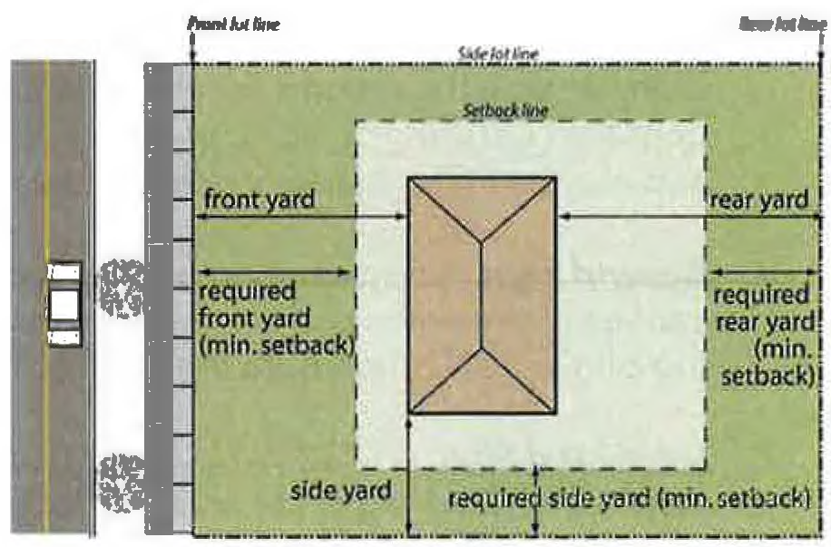
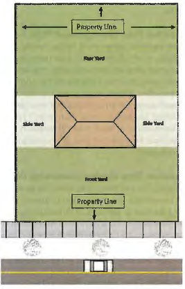
Setback. The horizontal distance between front, side, or rear lot lines and the nearest part of a STRUCTURE located on that LOT.
Setback, Required. The minimum required horizontal distance prescribed by the zoning district, measured from the front (typically a street right-of-way), side, or rear lot line to the nearest BUILDING wall or as otherwise specified for SINGLE-FAMILY detached CONDOMINIUMs.
Short-Term Rental. A residential dwelling that is rented or leased, or offered for rent or lease, as an overnight accommodation for periods of less than 30 consecutive days at any time during a calendar year. A SHORT-TERM RENTAL UNIT is generally used by renters and their guests in a manner that is consistent with the residential character of both the dwelling and the surrounding area. HOTELs, motels, inns, and bed and breakfasts are not considered SHORT-TERM RENTAL UNITs. Vacation time-sharing plans are not considered SHORT-TERM RENTAL UNITs and are prohibited pursuant to this ordinance.
Shrub. A woody plant, smaller than a tree, consisting of multiple stems originating from or near the ground that usually attains a mature height of no more than 15 feet.
Sign. Any device or representation for visual communication that is used for the purpose of bringing the subject thereof to the attention of others and which is located on or attached to premises, real property, STRUCTUREs on real property, or a vehicle, and which is visible from a street or parking area.
1.
Awning Sign. A SIGN painted on, printed on, or attached flat against the surface of an awning.
2.
Banner Sign. A SIGN of fabric, thin plastic or similar lightweight material that is mounted to a pole or a BUILDING at one (1) or more edges and is intended or displayed as commercial speech. Flags shall not be considered banners.
3.
Community Identification Sign. A SIGN identifying the name of the community, DEVELOPMENT, REGIME, or similar neighborhood entity.
4.
Community Message Board. A SIGN incorporated into a community identification SIGN to provide information regarding events, activities, or announcements via manually changed lettering or images.
5.
Electronic Variable Message Display. A portion of a community identification SIGN containing a screen, panel, or other area upon which alphanumeric characters, graphics or symbols are projected by illuminating devices including, but not limited to, light emitting diodes (LEDs), backlighted liquid crystal display (LCDs), plasma display panels (PDPs), fiber optics or light bulbs.
6.
Feather Sign. A freestanding SIGN, typically consisting of a single plastic or metal pole or shaft, stuck in the ground or otherwise fastened at the base, displaying an attached pennant consisting of fabric or other flexible material that is usually vertically elongated, and may be in the shape of a feather, tear drop, quill, or similar configuration.
7.
Ground Sign. A freestanding SIGN in which the entire bottom of the SIGN base is in contact with the ground or the sign is mounted on posts or columns. In either case, the top of the SIGN is not more than eight (8) feet above the surface of the ground.
8.
Incidental Sign. A SIGN, emblem or decal no larger than one and one-half (1½) square feet in area. Such signs are normally located on doors, windows, vending machines, and gas pumps or in PARKING LOTs or loading areas, may be freestanding or BUILDING signs, and are generally not readily visible or legible from public rights-of-way.
9.
Memorial Sign. A non-illuminated SIGN, tablet, or plaque commemorating a PERSON, event, STRUCTURE, or site.
10.
Nameplate. A non-illuminated, on-premises SIGN giving only the name, address, and/or occupation of the occupant or group of occupants of the premises.
11.
Official Signs. Signs placed by or at the direction of a governmental body, governmental agency, public authority, or SIPOA, such as but not limited to traffic signs, signals or regulatory devices or warnings; official emblems, public notices, or official instruments; signs providing directions to specific facilities or locations; signs identifying BUILDINGs or address ranges; signs designating temporary events or areas of architectural of historic significance or gateways; signs announcing or providing directions to a government sponsored event; or other similar governmental or public information signs or devices.
12.
Pole Sign. A SIGN mounted on one (1) or more freestanding posts or columns so the bottom of the SIGN body is elevated at least eight (8) feet above the ground, and the supporting posts or columns are each less than 25 percent of the width of the SIGN body.
13.
Portable Sign. Any SIGN, except a sidewalk/sandwich board SIGN, which is not permanently affixed to a BUILDING, STRUCTURE. or the ground.
14.
Projecting Sign. A double-faced SIGN attached to a BUILDING or wall that extends more than 12 inches but not more than 48 inches from the face of the BUILDING or wall.
15.
Roof Sign. A SIGN erected over or on, and wholly or partially dependent upon, the roof of any BUILDING for support, or attached to the roof in any way.
16.
Sandwich Board Sign. A freestanding movable SIGN, not secured or attached to the ground or any BUILDING or STRUCTURE, composed of a SIGN panel and supporting STRUCTURE or one (1) or more panels which form both the STRUCTURE and SIGN face.
17.
Snipe Sign. A SIGN which is tacked, nailed, posted, pasted, glued, or otherwise attached to trees, poles, stakes, or FENCEs, or to other objects, and the subject matter appearing thereon is not applicable to the present use of the premises upon which such SIGN is located.
18.
Wall Sign. A SIGN fastened directly to or placed directly upon the exterior wall of a BUILDING facade, with the SIGN face parallel to the wall and extending from the surface of the wall no more than 12 inches.
19.
Window Sign. Any SIGN which is permanently painted on, applied to, attached to, or projected upon the glass area of a BUILDING, including doors, and whose identification, message, symbol, insignia, visual representation, logo type, or any other form which communicates information is intended to be read from off-premises, contiguous property, or a public right-of-way.
20.
Yard Sign, Rigid Frame. A yard SIGN, consisting of a frame or skeleton made of steel, wood or similar sturdy material placed into the ground, that resists bending or movement and is capable of withstanding wind turbulence while supporting a SIGN of permitted size.
21.
Yard Sign, Wire Frame. A yard SIGN, usually consisting of a fairly pliable "H"-shaped wire frame, one end of which is typically inserted into a plastic SIGN and the other end is inserted into the ground.
SIPOA. The Seabrook Island Property Owners Association.
Site Development Plan. A detailed drawing showing proposed BUILDINGs, uses or reuses of all land, OPEN SPACE, location of major STRUCTUREs, recreation areas, schools and public facilities and such other planning elements and reasonable design criteria as deemed necessary to illustrate compliance with the requirements of this ordinance.
Small Wireless Facility. A wireless facility that meets both of the following qualifications: (i) each ANTENNA is located inside an enclosure of no more than six (6) cubic feet in volume, or, in the case of an ANTENNA that has exposed elements, the ANTENNA and all of its exposed elements could fit within an imaginary enclosure of not more than six (6) cubic feet; and (ii) all other wireless equipment associated with the facility is cumulatively no more than 28 cubic feet in volume. The following types of associated ancillary equipment are not included in the calculation of equipment volume: electric meter, concealment elements, telecommunications demarcation box, ground-based enclosures, grounding equipment, power transfer switch, cut-off switch, and vertical cable runs for the connection of power and other services.
Special Exception. A specific use listed as a special exception within one or more zoning districts and authorized, upon application, by the Board of Zoning Appeals in a specified location within a zoning district, upon finding that such use complies with all the conditions and standards specified for that use by the Development Standards Ordinance.
Street, Arterial. A major through street designed primarily for the movement of large volumes of traffic from one area to another.
Street, Collector. A public or PRIVATE STREET designed primarily to connect private ways serving MULTI-FAMILY complexes or other LOCAL STREETs with ARTERIAL STREETs and may be expected to carry a significant volume of traffic having neither origin nor destination on the street.
Street, Local. A public or PRIVATE STREET used primarily for providing direct access to abutting property.
Street, Private. Any vehicular access not dedicated to the public that has been platted and recorded as a PRIVATE STREET.
Street, Public. A street dedicated to the public and maintained by a governmental unit.
Structure. Anything constructed or erected, which requires, more or less, permanent location on the ground or is attached to something having a permanent location on the ground, including by way of example, but not limited to, BUILDINGs, sheds, PATIOs, PORCHes, gazebos, DECKs, tennis courts, screened enclosures, swimming pools, spas, driveways, parking areas, and sidewalks, unless otherwise stated in this ordinance. Lawfully erected UTILITY poles, basketball goals, play sets, and mailboxes, or any wall or STRUCTURE within the CRITICAL AREA and approved by SCDHEC-OCRM shall not be considered STRUCTUREs for purposes of this ordinance.
Structural Alteration. Any change or replacement in the supporting members of a BUILDING or STRUCTURE, including foundation, bearing walls or partitions, columns, beams, girders, or any structural change in the roof or exterior walls.
Subdivision. All divisions of a tract or parcel of land into two or more LOTs or other division, for the purpose, whether immediate or future, of sale, legacy, transfer, or resale and which involves all division of land involving a new street or change in existing streets.
Substantial Construction. The site has been rough-graded, drainage system and/or stormwater management facilities have been rough graded, EROSION and sedimentation control measures are in place, and construction of the use is actively proceeding to completion.
Substantial Modification. Any combination of REPAIRs, reconstruction, alteration, or IMPROVEMENTs to the exterior walls, roof, or supporting members of a BUILDING or STRUCTURE, including bearing walls, columns, beams, or girders.
Substantial Vegetation. All groupings of trees and SHRUBs whose spread is 20 feet or more in width.
T
Temporary Event. An activity having a specific duration, typically a few days but no more than a week, advertised with the intent to attract attendance or participation by large numbers of persons, and often involving vendor exhibits or booths, amplified sound, and sustained traffic. TEMPORARY EVENTs include, but are not limited to, such activities as: organized festivals, business promotions, tournaments, arts and crafts shows, and concerts. Events hosted on individual residential lots for personal celebration such as wedding receptions, graduation or birthday parties, and yard sales shall not be considered TEMPORARY EVENTs.
Temporary Structure or BUILDING. A portable BUILDING, trailer, tent, or similar STRUCTURE not located on a permanent foundation and intended to accommodate a use or activity of limited duration which is specifically permitted by this ordinance.
Town. The TOWN of Seabrook Island, South Carolina, a public body corporate and politic and political subdivision of the State of South Carolina.
Town Administrator. The individual appointed by TOWN COUNCIL pursuant to the provisions of Section 2-501 of the Town Code. Where authority is delegated by the TOWN ADMINISTRATOR to another individual, the term also includes his or her designee.
Traffic Impact Analysis. A specialized engineering study, prepared by a qualified transportation engineer, which determines the potential traffic impacts of a proposed use or DEVELOPMENT and, at a minimum, specifically addresses:
1.
The existing traffic conditions, expected future traffic conditions without the DEVELOPMENT, and expected future traffic conditions with the DEVELOPMENT in place for all roadway users;
2.
Expected traffic conditions during construction;
3.
Potential for existing and planned multimodal systems (bike paths, walking trails, transit) to accommodate the additional demand;
4.
Additional transportation needs, beyond those already programmed or included in the local transportation plan, required to maintain a satisfactory level of service (LOS); and
5.
Recommended roadway and/or system IMPROVEMENTs that may be necessary to accommodate the expected DEVELOPMENT traffic.
U
Use. The purpose for which a BUILDING, LOT, SIGN, or STRUCTURE is intended, designed, occupied, or maintained:
1.
Use, Accessory. A use of land or BUILDING, or a portion thereof, that is subordinate to, and customarily associated with, the PRINCIPAL USE.
2.
Use, Nonresidential. Any use of property or BUILDINGs that is not a RESIDENTIAL USE.
3.
Use, Principal. The primary purpose for which a LOT or the main BUILDING thereon is designed, arranged, or intended and for which it is or may be used.
4.
Use, Residential. A PRINCIPAL USE that is intended for occupancy by an owner or lessee as their permanent place of abode.
5.
Use, Temporary. A use of a LOT or LOTs of limited duration and established in connection with a construction project, real estate DEVELOPMENT, TEMPORARY EVENT, or similar activity of a limited duration.
Utility, Private. Any privately-owned company or corporation which provides the general public with electricity, gas, heat, steam, communication, transportation, water, sewage collection, and/or treatment or other services.
Utility, Public. Any agency which, under public franchise or ownership provides the general public with electricity, gas, heat, steam, communication, transportation, water, sewage collection and/or treatment, or other services.
Utility Substations and Subinstallations. Control STRUCTUREs and transformers and STRUCTUREs housing transformers, pumps, and similar equipment operated by a public utility or other bona fide entity providing water, sanitary sewer, communications, or similar services to the general public.
V
Vacation Club Unit. A residential dwelling that is owned, leased, or managed by a private membership organization or commercial business entity that is engaged in providing short-term overnight accommodations and related services to its members. Vacation clubs typically own or lease properties on a long-term basis, offer and rent those properties to the club's members on a short-term basis, and model a membership structure where its members purchase membership levels granting access to a portfolio of properties and personalized services, but does not convey upon its members an ownership interest in the properties. Properties offered by vacation clubs to members for less than 30 consecutive days are considered SHORT-TERM RENTAL UNITs, regardless of whether the vacation club is the owner of record, lessee, or manager of the property. All applicable references to "owners" in this ordinance shall similarly apply to vacation clubs.
Vacation Time Sharing Lease Plan. Any arrangement, plan, or similar devise, whether by membership agreement, lease, rental agreement, license, use agreement, security, or other means, in which the purchaser receives a right to use accommodations or facilities, or both, but does not receive an ownership interest in real property, for a period or periods of time during a given year, but not necessarily for consecutive years, which extends for a period of more than three (3) years. These lease plans do not include an arrangement or agreement in which a purchaser in exchange for an advance fee and yearly dues is entitled to select from a designated list of facilities located in more than one (1) state, accommodations of companies that operate nationwide in at least nine (9) states in the United States through franchises or ownership, for a specified time period and at reduced rates and under which an interest in real property is not transferred.
Vacation Time Sharing Ownership Plan. Any arrangement, plan, or similar devise, whether by tenancy in common, sale, term for years, deed, or other means, in which the purchaser receives an ownership interest in real property and the right to use accommodations or facilities, or both, for a period or periods of time during a given year, but not necessarily for consecutive years, which extends for a period of more than one (1) year. A vacation time sharing ownership plan may be created in a CONDOMINIUM established on a term for years or leasehold interest having an original duration of 30 years or longer. An interest in a vacation time sharing ownership plan is recognized as an interest in real property for all purposes pursuant to the laws of this State.
Vacation Time Sharing Plan. Either a vacation time sharing ownership plan or a vacation time sharing lease plan. Trusts, partnership interests, undivided interests as tenants in common, corporate shares, or other membership or use interests in a DWELLING UNIT, in which 13 or fewer undivided interests, corporation shares, partnership interests, trust interests, or other membership or use interests are conveyed, are not considered a vacation time sharing plan or a time-sharing unit for purposes of this ordinance.
Variance. An authorization by the Board of Zoning Appeals granting relief from the strict requirements of this ordinance and doing substantial justice, where literal enforcement would result in a practical difficulty or unnecessary hardship.
W
Waterbody. Any pond, lake, lagoon, channel, or basin which ordinarily or intermittently contains water and which has a discernible shoreline including those that are the result of DEVELOPMENT.
Wetland. Any area subject to periodic or intermittent flooding and defined and/or regulated as a "WETLAND" by either the state and/or federal government.
X
Reserved.
Y
Yard. The open spaces on a LOT located between a BUILDING and a lot line. The term "required yard" shall refer to that portion of the yard lying between the lot lines and the minimum required SETBACK lines.
1.
Yard, Front. The space extending the full width of the LOT, the depth of which is the distance between the front lot line and the nearest BUILDING LINE of the principal BUILDING.
2.
Yard, Rear. The space extending the full width of the LOT, the depth of which is the distance between the rear lot line and the nearest BUILDING LINE of the principal BUILDING.
3.
Yard, Side. The space between a principal BUILDING and the side lot line, extending from the FRONT YARD to the REAR YARD, the width of which is the distance from the side lot line to the nearest BUILDING LINE of the principal BUILDING.
Z
Zoning Administrator. The PERSON appointed by the Mayor, or the Mayor's designee, to administer and enforce the provisions of this ordinance. Where authority is delegated by the ZONING ADMINISTRATOR to another individual, the term also includes his or her designee.
Zoning Permit. A required pre-DEVELOPMENT or pre-construction authorization issued by the TOWN, as generally described in Section 18.2 of this ordinance.