
Tecumseh City Zoning Code
ARTICLE V
- OVERLAYS AND PLANNED DEVELOPMENT DISTRICTS
Sec. 98-121. - Statement of purpose.
The intent of this division is to implement the provisions of Public Act 110 of 2006, as amended, authorizing the use of planned unit developments (hereinafter "PUDs") to allow regulatory flexibility in the consideration of proposed land uses within the City consistent with the requirements of the City's Master Plan. It is the intent of the City that the standards of the Zoning Ordinance may be increased, decreased, waived, or otherwise modified under the provisions of this division to promote the development that achieves one or more of the following objectives: a significantly greater preservation of open space and natural resources; providing community amenities; assisting in the redevelopment of downtown and the surrounding neighborhoods; or other recognizable benefits beyond those afforded by development which adheres to the minimum requirements of the underlying zoning classification applicable to the property.
(Ord. No. O-06-25, § 1(Exh. A), 8-4-2025)
Sec. 98-122. - Qualifying conditions.
The following provisions shall apply to all PUDs:
(a)
The planned unit development site shall be under the control of one owner or group of owners and shall be capable of being planned and developed as one integral unit.
(b)
A PUD may only be approved in conjunction with an approved PUD concept plan and a written and recorded PUD agreement between the City and the property owner(s).
(c)
A PUD may be approved in any zoning district and shall have a contiguous area of at least five (5) acres. When a PUD is proposed in a district currently zoned Downtown district (D-1, D-2, or D-3) or within a master plan subarea that supports mixed use development and/or redevelopment, Planning Commission may waive the minimum acreage requirement with the following findings:
(1)
The site has sufficient access to public roads and will be designed to support walking and biking.
(2)
The site design includes public space or is within one-half-mile of a public park.
(3)
The site is of a sufficient size to support all necessary infrastructure for the proposed development.
(d)
The City may approve a PUD on certain property or properties following the application and approval procedures below.
(e)
The application must demonstrate that the proposed PUD is recommended for planned unit development in the City's adopted master plan or includes areas indicated in the City's adopted master plan as having significant natural, historical, or architectural features. The City may also qualify sites where an innovative, unified, and planned approach to developing the site would result in a significantly higher quality of development, the mitigation of potentially negative impacts of development, or more efficient development than conventional zoning would allow.
(f)
The uses contained in a PUD with more than one (1) type of use shall be complementary in nature.
(g)
If a PUD includes residential uses, the housing types must be clustered to preserve common open space, in a design not feasible under the underlying zoning district regulations.
(h)
A PUD shall achieve a higher quality development than is otherwise possible with the regulations for the underlying zoning district.
(i)
A PUD shall result in a recognizable and substantial benefit to ultimate users of the project and to the community. The benefit to the community must be proportionate to the modifications of the City standards being requested. Such benefits may include, but are not limited to the following:
(1)
Preservation or enhancement of significant natural features or open space.
(2)
Provide a complementary variety of housing types and/or a complementary mixed-use plan of residential and commercial uses that is harmonious with adjacent development.
(3)
Provide a civic facility or other public improvement.
(4)
Alleviate traffic congestion.
(5)
Provide for the appropriate redevelopment or re-use of sites designated as local historic districts (including noncontiguous districts), or parcels occupied by prior or obsolete nonresidential uses.
(6)
A PUD shall advance certain other public objectives as identified in the City Master Plan.
(Ord. No. O-06-25, § 1(Exh. A), 8-4-2025)
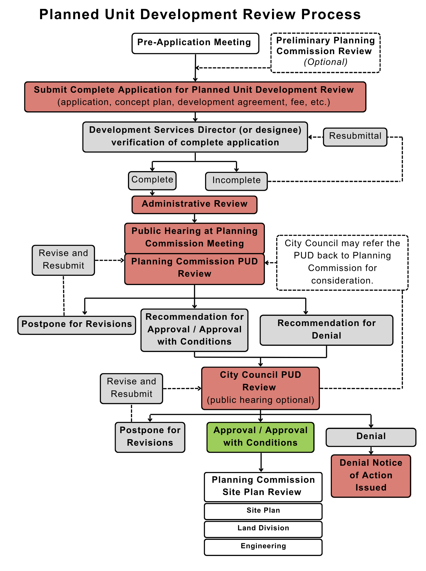
Sec. 98-123. - PUD review process.
The PUD review process consists of the following procedures:
(a)
Pre-application meeting. Before submitting an application for approval of a PUD, the applicant shall confer in a pre-application meeting with the City manager and the development services director to obtain information and guidance regarding land development regulations, the City's Master Plan and the application process. At the pre-application meeting the applicant shall submit a concept plan for the proposed PUD, containing both maps and a written statement. The plan should include enough of the surrounding area to demonstrate the relationship of the PUD to adjoining uses, both existing and proposed, and should contain sufficient detail to permit a meaningful exchange of ideas between the applicant and City staff regarding the suitability of utilizing a PUD approach to the development of the subject property.
(b)
Optional preliminary review. An applicant may request a preliminary review by the planning commission. Sufficient information regarding the proposed uses, density, intensity, road layouts, design concepts, and the relationship of the proposed PUD to surrounding area must be provided. The planning commission shall take no formal action during preliminary review.
(c)
Planning commission review of PUD. Upon completion of the preapplication conference stage, a PUD application meeting the requirements of Sec. 98-124 shall be submitted to the planning commission for its review.
(d)
Public hearing. At least one (1) public hearing on the PUD shall be held by the planning commission, with notice being given in accordance with Sec. 98-28.
(e)
Recommendation by planning commission. After the public hearing, the planning commission, using the standards in Sec. 98-122 and, to the extent they are applicable to review of the PUD application, the standard in Sec. 98-127, shall make a recommendation to the City council of approval, approval with modifications, or disapproval of the PUD, as represented by the PUD plan and accompanying materials. The planning commission shall prepare a report stating its conclusions on the PUD request, the basis for its recommendation, the recommendation, and any conditions relating to an affirmative recommendation.
(f)
City council review of PUD. Upon receipt of the planning commission's recommendation, the City council shall make a decision on the PUD application. Based upon the standards in Sec. 98-122 and, to the extent they are applicable to review of the PUD application, the standards in Sec. 98-127, the City council may deny, approve, or approve with conditions the proposed PUD. The City council shall prepare a report stating its conclusions on the PUD application, the basis for its decision, the decision, and any conditions relating to an affirmative decision.
(g)
PUD Site plan review. A complete site plan shall be submitted for review pursuant to Sec. 98-32 (Site plan review process), for each phase(s) of an approved PUD plan.
(h)
Enforcement. The development services director shall review all building permits for an approved PUD project for compliance with the terms of the approved PUD agreement, and any other applicable codes and ordinances.
(i)
Summary of PUD review process. The following figure summarizes the PUD review process:
(Ord. No. O-06-25, § 1(Exh. A), 8-4-2025)
Sec. 98-124. - PUD application submittal requirements.
The PUD application shall include all the following information, unless the development services director determines that some of the required information is not reasonably necessary for the consideration of the PUD:
(a)
Application form and required fee.
(1)
A narrative indicating the period of time within which it is contemplated the project will be completed.
(2)
A concept plan showing a layout of the uses and structures in the PUD and their locations.
(3)
Written verification of access easements or agreements, if applicable.
(4)
A note on each plan sheet stating: "Not to be used as construction drawings."
(5)
Information pursuant to 98-285 and any additional graphics or written materials reasonably requested by the planning commission or City council to assist in determining the impacts of the proposed site plan, including, but not limited to, economic or market studies; impact on public primary and secondary schools and utilities; traffic impacts; impact on significant natural, historical, and architectural features and drainage; impact on the general area and adjacent property; and estimated construction cost.
(6)
Additional information that may be reasonably necessary for a full and complete consideration of the proposed PUD and its impact on the immediately surrounding area and the City as a whole.
(7)
Draft PUD agreement between the City and the applicant, which shall include, among other items, a provision as to such revisions to the site plan that may be approved administratively by the planning commission, any specific terms and conditions relating to an approved PUD including specific terms relating to the administration of the project.
(8)
The application for PUD review shall include a community impact statement. The statement shall be derived from a study of the City based on information from the following community elements:
a.
Planning/zoning issues, including conformance with the Master Plan, Zoning Ordinance, and other applicable City codes and policies;
b.
Land development issues, including topographic, soil conditions, and site safety concerns;
c.
Private utilities consumption, including electrical needs and natural gas utilization;
d.
Noise level conditions;
e.
Air quality conditions;
f.
Environmental design and historic values including visual quality and historic resources;
g.
Community facilities and services, including refuse collection, sanitary and storm sewer, and water supply;
h.
Public safety needs, including police, fire and emergency medical services;
i.
Open space landscaping and recreation, including cultural elements;
j.
Traffic impact study.
(Ord. No. O-06-25, § 1(Exh. A), 8-4-2025)
Sec. 98-125. - Site plan review.
For the total PUD or for each portion of the PUD, if staging of development is planned, a site plan review is required in accordance with Article II, Division 3 of this chapter prior to the issuance of zoning permits. The site plan submittal shall include all of the information required by Sec. 98-33.
(Ord. No. O-06-25, § 1(Exh. A), 8-4-2025)
Sec. 98-126. - Regulatory flexibility.
The City council, either during the PUD review stage, or after site plan review by the planning commission, may increase, decrease, waive, or otherwise modify the current standards within the Zoning Ordinance including, but not limited to: use, density, intensity, setbacks, building heights, parking, project design standards of Sec. 98-127, and landscape standards provided the modification is found to improve the quality of development above and beyond what could be developed under the underlying zoning, or results in a higher level of public benefit, and to achieve the purpose of this article.
(Ord. No. O-06-25, § 1(Exh. A), 8-4-2025)
Sec. 98-127. - Project design standards.
The following standards are intended as guidelines and may be modified by the City under the provisions of Sec. 98-126:
(a)
Standards of approval. The planning commission and City council shall use any applicable standards for approval contained in City ordinances related to land use and any adopted development guidelines, as well as the standards contained in Public Act 184 of 1943, as amended, which are not inconsistent with the approved PUD plan or the PUD agreement, in reviewing and approving a site plan.
(b)
Use. The uses proposed shall be consistent with the City's Master Plan or the approved PUD concept plan.
(c)
Density. For areas of detached single-family housing, the density may not exceed three (3) dwelling units per acre; for areas for residential uses other than detached single-family housing, the density may not exceed eight (8) dwelling units per acre; for areas mixing detached single-family housing with other types of housing, appropriate density, lot sizes and developmental provisions shall be determined by the City council following review by the planning commission, considering the requirements of such districts. The City may permit proportionate increases in density or intensity for projects that demonstrate a significant public benefit to the City.
(d)
Open spaces and recreation areas. At least twenty percent (20%) of the total PUD acreage shall be in open space and recreation area, including plazas. However, regulated wetland areas and detention ponds may cumulatively count for a maximum of ten percent (10%) of the minimum open space and recreation area requirement. That portion of a regulated wetland area within one hundred (100) feet of the boundary of the regulated wetland may be counted toward the overall density of a proposed project provided the overall project will further a certain public objective such as natural feature preservation, public improvements, or other items included in the City Master Plan, which could not be otherwise achieved under conventional zoning, or if provided for in the PUD agreement.
(e)
Impact on surrounding uses. The uses proposed will have a beneficial effect, in terms of public health, safety, welfare, or convenience, on present and future potential surrounding land uses. The uses proposed will not adversely affect the public utility and circulation system, surrounding properties, or the environment. The public benefit shall be one that could not be achieved under the regulations of the underlying district alone, or that of any other single zoning district.
(f)
Parking. The number and dimensions of off-street parking spaces shall be sufficient to meet the minimum required by the Zoning Ordinance. However, if the parking needs of the development can be met by a modification of such requirements, or where warranted by overlapping or shared parking arrangements, or where parking spaces can simultaneously accommodate more than one (1) use, the planning commission or City council may adjust the required number of parking spaces. The City council may also allow portions of required parking spaces to be banked as open space until determined either by the owner or the City that such spaces should be improved.
All streets and parking areas within the planned unit development shall meet the minimum construction and other requirements of City ordinances, unless modified by the City council.
(g)
Landscaping. Existing landscaping shall be preserved and/or improved or additional landscaping be provided to ensure that proposed uses will be adequately buffered, where buffering is appropriate, from one another and from surrounding public and private property. The quality and/or quantity of landscaping materials shall exceed the minimums otherwise required by this chapter.
(h)
Existing features. The PUD plan shall demonstrate that the plan will preserve significant natural, historical, and architectural features, if any, and the integrity of the land.
(i)
Utilities. Public water and sewer facilities shall be available or shall be provided for by the developer as part of the site development.
(j)
Circulation. Safe, convenient, uncongested, and well-defined vehicular and pedestrian circulation within and into the site shall be provided.
(1)
Drives, streets and other elements within the property shall be designed to implement the circulation plan in the City Master Plan to promote safe and efficient traffic operations within the site and at its access points.
(2)
Sidewalks or multipurpose paths shall be provided along major thoroughfares, where identified in the City's Master Plan, and within the development, if deemed appropriate by the planning commission to provide safe and efficient non-motorized circulation.
(Ord. No. O-06-25, § 1(Exh. A), 8-4-2025)
Sec. 98-128. - Status of City council approval.
(a)
Approval of a PUD application and execution and recording at the county register of deed's office of a PUD agreement containing all of the terms and conditions of approval by the City council confers on the applicant and any subsequent owners of the PUD property the right to utilize the property included as part of the approved PUD in accordance with the approved PUD and in accordance with the PUD agreement. The provisions of the PUD agreement shall prevail over any inconsistent provisions of this chapter or any other City ordinance. An approved site plan shall take precedence over the approved PUD concept plan for the area of the approved site plan. Site plan approval shall be granted only upon a determination by the planning commission that a proposed site plan is consistent with all of the terms of the approved PUD agreement and the approved concept plan.
(b)
The City council may cause to have legal documents, covenants or contracts prepared which are not inconsistent with the PUD agreement, and may require the execution thereof by the applicant, which documents involve the City and are required as a result of the conditions contained in the PUD agreement or the site plan approvals in a PUD area.
(c)
The development services director shall review all building permits for an approved PUD project for compliance with the terms of the approved PUD agreement, and any other applicable codes and ordinances.
(d)
The development services director or their designee shall inspect the development at each stage to ensure reasonable compliance with the conditions of the approved PUD or approved site plans, as applicable.
(Ord. No. O-06-25, § 1(Exh. A), 8-4-2025)
Sec. 98-129. - Revocation or changes.
The City council, upon a breach of the PUD agreement may revoke a PUD or any portion thereof. Revocation of any portion of a PUD shall revert that portion of the PUD to the status and requirements of the original zoned district, without benefit of the PUD provisions. Proposed changes in a PUD, other than those considered a part of site plan review for all or a portion of the PUD must be processed in the same manner as the original PUD procedure.
(Ord. No. O-06-25, § 1(Exh. A), 8-4-2025)
Sec. 98-130. - Appeals and violations.
The zoning board of appeals shall not have the authority to change specific PUD written conditions, or make interpretations to an approved site plan, which right is reserved to the City council. In considering an appeal or interpretation of an approved PUD, the City council may request input from the planning commission.
(Ord. No. O-06-25, § 1(Exh. A), 8-4-2025)
Sec. 98-131. - Violations and enforcement.
(a)
Any violation or deviation from an approved site plan or written conditions, except as authorized in this section, shall be considered a violation of Sec. 98-128 and treated as a violation of this section. Furthermore, any such deviation may be grounds to invalidate the PUD designation.
(b)
The cost of enforcing violations of the approved PUD site plan or agreement shall be borne by the developer or their successors.
(Ord. No. O-06-25, § 1(Exh. A), 8-4-2025)
Sec. 98-132. - Preamble.
The PRD planned residential district allows a mixture of types of residential units (single-family, two-family, multiple-family). Development under this chapter shall be in accordance with a comprehensive physical plan establishing functional use areas, density patterns and a mixed system of residential collector streets. Approval of a planned residential development under this article shall be considered an optional method of development and improvement of property subject to the mutual agreement of the City and the applicant.
(Ord. No. O-06-25, § 1(Exh. A), 8-4-2025)
Sec. 98-133. - Mapped zoning district.
A PRD is a mapped zoning district, and land must be zoned PRD prior to the submittal of a site plan for any development according to the standards of this chapter.
(Ord. No. O-06-25, § 1(Exh. A), 8-4-2025)
Sec. 98-134. - Principal uses permitted.
Principal permitted uses in the RA-1 and RA-2 districts are permitted in PRD districts.
(Ord. No. O-06-25, § 1(Exh. A), 8-4-2025)
Sec. 98-135. - Special land uses.
The following uses may be permitted in a PRD following special land use approval:
(a)
Two-family dwellings.
(b)
Multiple-family dwellings.
(1)
Row houses.
(2)
Terraces.
(3)
Apartments.
(4)
Efficiency apartments.
(5)
Townhouses.
(c)
Rental or management offices and club rooms accessory to the planned residential development.
(d)
Churches.
(e)
Public, parochial and private elementary schools and/or high schools offering courses in general education.
(f)
Golf courses in accord with an approved plan.
(g)
Public libraries, parks, parkways and recreational facilities.
(h)
Private parks and recreation areas for the use of the residents of the planned residential development.
(i)
Accessory uses and accessory buildings, including parks and recreational facilities.
(Ord. No. O-06-25, § 1(Exh. A), 8-4-2025)
Sec. 98-136. - Height, bulk, density, and land area.
(a)
Density. For purposes of computing and controlling population density, the following standards shall apply:
(1)
Calculating parcel area. The entire gross area of the planned residential development, including street rights-of-way, parks, schools and other public or private open space, shall be included in the computation of area; however, school sites may be included only to a maximum of fifteen (15) acres or twenty-five percent (25%) of the total open space, whichever is the lesser amount. Subaqueous or submerged bottom land of lakes or streams shall be excluded in computing the area of a parcel; except that when land abutting such lakes or streams is substantially developed in park or open space for the use of residents of the PRD, the surface area of such lakes or streams may be used to compute density.
(2)
Density. Maximum dwelling unit density shall not exceed four and one-half (4½) dwelling units per acre for the total site area being proposed for development as a planned residential development.
a.
Not more than sixty percent (60%) of the number of dwellings permitted for the entire development shall be in attached dwelling units (multiple-family and cluster housing units).
b.
For purposes of computing density, a den, library or other extra room shall not count as a bedroom unless a closet opens directly to the room.
c.
Not more than thirty percent (30%) of the units in a PRD district may be one (1) bedroom or efficiency units.
(b)
Density transition. In order to provide an orderly transition of density, where the project being proposed for use as a PRD immediately abuts an RA-1 or RA-2 district, the City may require that the area immediately abutting and within three hundred (300) feet of the RA-1 or RA-2 district shall be developed in single-family lots, or shall be developed as open or recreation space.
(c)
Single-family requirements. Single-family dwellings shall be subject to the requirements applicable to the RA-1 or RA-2 district, as determined by the City council after recommendation is received from the planning commission. The planning commission has the ability to modify the setbacks and lot area requirements.
(d)
Multiple family requirements. Multiple dwellings shall be subject to the requirements applicable to the RM-1 or RM-2 district, as determined by the City council after recommendation is received from the planning commission. The Planning Commission has the ability to modify the setbacks and lot area requirements.
(Ord. No. O-06-25, § 1(Exh. A), 8-4-2025)
Sec. 98-137. - Required conditions.
All dwelling units shall comply with the requirements of Sec. 98-112.
(Ord. No. O-06-25, § 1(Exh. A), 8-4-2025)
Sec. 98-138. - Application and review procedures.
The person owning and controlling land zoned PRD may make application to the City council for consideration under this section. The person applying shall be required to submit the following materials to the City council:
(a)
Submittal of proposed PRD plan. An application shall be made to the development services director for review and recommendation by the planning commission of the following:
(1)
A boundary survey of the exact acreage being requested done by a registered land surveyor or civil engineer (scale: not smaller than one (1) inch equals two hundred (200) feet).
(2)
A topographic map of the entire area at a contour interval of at least one (1) inch equals two (2) feet. This map shall indicate all major stands of trees, bodies of water and unbuildable areas (scale: not smaller than one (1) inch equals two hundred (200) feet).
(3)
A recent aerial photograph of the area shall be provided (scale: not smaller than one (1) inch equals two hundred (200) feet).
(4)
A preliminary plat for the entire area carried out in such detail as to indicate the functional uses and dwelling unit types being requested; the proposed population densities; a traffic circulation plan; sites being reserved for schools, service activities, playgrounds, recreation areas, parking areas, and other open spaces and areas to be used for the public or by residents of the planned residential development (scale: not smaller than one (1) inch equals two hundred (200) feet).
(5)
An indication of the contemplated storm and sanitary sewer plan, and a preliminary topographic map indicating how the land area is proposed to be shaped.
(6)
A written statement explaining in detail the full intent of the sponsor, indicating the type of dwelling units contemplated, resultant population and providing supporting documentation such as soil surveys, studies supporting land use requests, and the intended scheduling of the development.
(b)
Review of proposed PRD plan. Upon receipt of an application as a preliminary submittal, the City clerk shall refer such request to the planning commission for its report and recommendation. Prior to making such report and recommendation, the planning commission shall hold a public hearing on the application. Following the public hearing and receipt of the planning commission's report and recommendation, the council may approve the application and accompanying plan only upon finding that:
(1)
All applicable provisions of this article and this division have been met. Insofar as any provision of this article shall be in conflict with the provisions of any other section of this chapter, the provisions of this article shall apply to the lands embraced within a planned residential development area.
(2)
Adequate areas have been provided for all utilities, schools, walkways, playgrounds, recreation areas, parking areas and other open spaces and areas to be used by the public or by residents of the community.
(3)
Open space may include parks and recreation areas, wooded lots, golf courses, schools, water areas and any use of a similar nature approved by the City council; however, at least one (1) acre for each fifty (50) dwelling units shall be preserved as park, recreation or open space rather than as a golf course, water area, road right-of-way, school or similar limited-use area. Yard areas required for single-family cluster housing or multiple-family units shall not count as part of this open space requirement.
(4)
In planned residential districts any prorated open space shall be committed by dedication to an association of residents, as rights-in-fee, easements, or in a master deed, and retained as open space for park, recreation and related uses. All lands dedicated in fee or easement shall meet the requirements set forth by the City council. Provisions satisfactory to the City council shall be made to provide for the financing of any improvements shown on the plan for open spaces and common use areas which are to be provided by the applicant, including maintenance of such improvements by a means satisfactory to the City council. This may include a development agreement. Such documents shall be recorded with the county register of deeds.
(5)
There is or will be at the time of development an adequate means of disposing of sanitary sewage and of supplying the development with water, and the road system and stormwater drainage system is adequate.
(6)
The plan provides for an efficient, aesthetic and desirable use of the open areas, and the plan is in keeping with the physical character of the City and the area surrounding the development.
(7)
The applicant has made provision, satisfactory to the council, to ensure that those areas shown on the plan for use by the public or occupants of the development will be or have been committed for that purpose. The council may require that conveyances or other documents be placed in escrow to accomplish this.
(8)
Provisions satisfactory to the council have been made to provide for the future financing of any improvements shown on the plan for open space areas, and common use areas which are to be included within the development and that maintenance of such improvements is assured by a means satisfactory to the council.
(9)
The cost of installing all streets and the necessary utilities has been assured by a means satisfactory to the council.
(10)
The council may require guarantee for the completion of improvements.
(c)
Approval of PRD by City council.
(1)
If the council shall determine to grant the application and approve the plan, it shall instruct the City attorney to prepare a contract setting forth the conditions upon which such approval is based, which contract, after approval by resolution of the council, shall be executed by the City and the applicant and recorded in the office of the county register of deeds. Approval shall be effective upon recording.
(2)
Once an area has been included within a plan for planned residential development and such plan has been approved by the council, no development may take place in such area, nor may any use be made except in accordance with the plan or in accordance with a council-approved amendment unless the plan is terminated as provided in this section.
(3)
An approved plan may be terminated by the applicant or its successors or assigns, prior to any development within the area involved, by filing with the City and recording in the county records an affidavit so stating. The approval of the plan shall terminate upon said recording.
(4)
No approved plan shall be terminated after development commences except with the approval of the City council and of all parties in interest in the land.
(5)
Within a period of two (2) years following approval by the council, final plats and/or site plans for an area embraced within the planned residential development must be submitted as provided in this article. If such plats and/or plans have not been submitted and approved within the two-year period, the right to develop under the approved plan may be terminated by the City.
(Ord. No. O-06-25, § 1(Exh. A), 8-4-2025)
Sec. 98-139. - Regulatory flexibility.
The City council, either during the PRD review stage, or after site plan review by the planning commission, may increase, decrease, waive, or otherwise modify the current standards within the Zoning Ordinance including, but not limited to: use, density, intensity, setbacks, building heights, parking, and landscape standards provided the modification is found to improve the quality of development above and beyond what could be developed under the existing Zoning Ordinance requirements, or results in a higher level of public benefit, and to achieve the purpose of this article.
(Ord. No. O-06-25, § 1(Exh. A), 8-4-2025)
Sec. 98-140. - Submittal of final plats or site plans.
(a)
Site plan or final plat approval required. Before any building permits may be issued for buildings and structures in a PRD, final plats, site condominium plans, and/or site plans for a project area shall be submitted to the City for review. The plat or site plan shall comply with all of the procedures and requirements applicable under this chapter and other City ordinances, and shall also comply with the following requirements:
(1)
Site plans and plats shall be fully dimensioned and shall show a fully scaled plan view of all buildings (except detached single-family dwellings), all public rights-of-way and private streets, areas within each project area and their proposed ultimate density, parking areas, utilities, churches, schools and areas to be set aside for the use of the public or by residents within the development (scale one (1) inch equals fifty (50) feet).
(2)
The proposed topography (contours of at least two-foot intervals) shall be superimposed on all plats and plans (scale one (1) inch equals fifty (50) feet).
(3)
Floor plans typical of all residential buildings except detached single-family shall be submitted, and the site plan shall indicate which floor plan is applicable to each such building.
(4)
Each final plat and/or site plan submitted within the planned residential development shall, either individually or in combination with previously approved project areas, meet the standards of this chapter as to density.
(5)
Open space and its development and use shall be subject to the review and approval by the planning commission and the City council.
(6)
The planning commission may require, as part of a final site plan review of a phase of a PRD, that land shown as open space on the approved area plan be held in reserve as part of the phase to be developed, in order to guarantee that density limits for the entire approved PRD will not be exceeded when the subject phase is completed. Such reserved land may be included in the development of subsequent phases if the density limits will not be exceeded upon completion of that phase or if other land is similarly held in reserve.
(b)
Required determinations. Before approving of any final plat or plan, the council shall determine that:
(1)
All portions of the project area shown upon the approved plan for the planned development for use by the public or the residents of lands within the planned development have been committed to such uses in accordance with the planned development contract.
(2)
The final plats and/or site plans are in substantial conformity with the approved plan for the PRD.
(3)
Provisions have been made in accordance with the PRD contract to provide for the financing of any improvements shown on the project area plan for open spaces and common areas which are to be provided by the applicant and that maintenance of such improvements is assured in accordance with the PRD contract.
(4)
A dedication of public roads shall have been made so as to cause continuity of public access between the adjacent major thoroughfare and ingress and egress to all private development within the project area plan.
(c)
Building permits. During construction of the planned residential development, building permits for residential structures shall be issued in such a manner as to assure that on a cumulative basis not less than thirty-three and one-third percent (33⅓%) of the total number of bedrooms (for which permits are or have been issued) shall be in single-family dwellings. Occupancy permits shall not be issued for other than single-family dwellings until occupancy permits have been issued for not less than fifty percent (50%) of the single-family dwellings which are necessary to maintain the thirty-three and one-third percentage (33⅓%) of bedrooms. The planning commission may waive these requirements to the extent that a minimum number of model units could be displayed by the developer.
(1)
The ratio of single-family bedrooms to the total number of bedrooms within the planned residential development for which occupancy permits will be issued may be altered by the planning commission from fifty percent (50%) to a minimum of ten percent (10%), as long as the building permit ratio is not altered.
(2)
In no situation will multiple-family construction permits be issued unless at least three single-family bedroom (one (1) single-family structure) occupancy permits have been issued.
(d)
Completion of open space. In order to ensure the development of open space in conjunction with a PRD, the City council shall include in the contract, recorded with register of deeds, a schedule for the completion of portions of the open space so that it coincides with completion of dwelling units. The developer may suggest a schedule for review by the council.
(e)
Completion. If development of approved final plats, site condominium plans and/or site plans is not substantially completed in three (3) years after approval, further final submittals under the planned residential development shall cease until the part in question is completed or cause can be shown for not completing the part.
(Ord. No. O-06-25, § 1(Exh. A), 8-4-2025)
Sec. 98-141. - Fees.
Fees for review of site plans shall be established by resolution of the City council.
(Ord. No. O-06-25, § 1(Exh. A), 8-4-2025)
Sec. 98-142. - Amendment.
Any changes or amendments requested shall terminate approval of the overall plan until such changes or amendments have been reviewed and approved as in the first instance. In instances where modifications are necessary to the plan, the building official may request that the plan be again submitted for review if, in his judgment, a substantial change is being made in the plan.
(Ord. No. O-06-25, § 1(Exh. A), 8-4-2025)
Sec. 98-143. - Preamble.
For the purposes of this section, an environmental residential community (the ERC) is defined as a residential development that is designed to have a minimal impact on the existing natural resources of the site and within which a portion of significant natural area is permanently preserved and explicitly protected from any future development.
(Ord. No. O-06-25, § 1(Exh. A), 8-4-2025)
Sec. 98-144. - Intent.
(a)
It is the intent of this section to provide a method for residential development that preserves and protects significant natural areas and waterways in perpetuity.
(b)
This section is designed through the use of planned unit development legislation as authorized in Section 503 of the Michigan Zoning Enabling Act.
(c)
The landscape shall be preserved in its natural state, insofar as practicable, by minimizing tree and soil removal. The orientation of individual building sites shall be such as to maintain maximum natural topography and cover. Topography, tree cover, and natural drainage ways shall be treated as fixed determinants of road and lot configuration rather than as malleable elements that can be changed to follow a preferred development scheme.
(d)
Streets shall be designed and located in such a manner as to maintain and preserve natural topography, cover, significant landmarks, and trees; to reduce impervious surface; to minimize cut and fill; and to preserve and enhance views and vistas on and off the subject parcel. Innovative stormwater management practices shall be encouraged that are protective of the natural resources.
(e)
Proposed development shall be related harmoniously to the terrain and to the use, scale, and architecture of existing buildings in the vicinity that have functional or visual relationships to the proposed buildings. Proposed buildings/structures shall be related to their surroundings.
(f)
All open space shall be designed to add to the visual amenities of the area for persons passing the site or overlooking it from nearby properties.
(g)
The color, size, height, lighting, and landscaping of appurtenant signs and structures shall be evaluated for compatibility with the local architectural motif and the maintenance of views and vistas of natural landscapes, recognizing historic landmarks, natural areas, parks, and landscaping.
(h)
The removal or disruption of environmentally significant features shall be prohibited. Environmentally significant features may include, but are not limited to, woodlands, vegetation, natural area, sloping land, wildlife habitat, scenic vistas, wetlands and waterways on the site. Additional care must be taken as a result of any construction activity that no negative impact of environmentally significant features on adjacent property shall occur.
(Ord. No. O-06-25, § 1(Exh. A), 8-4-2025)
Sec. 98-145. - Qualifying conditions.
To be eligible for development as an environmental residential community, the applicant must present a proposal for residential development that meets all of the following requirements:
(a)
Recognizable benefits. The ERC shall provide a benefit to the environment as well as to the residents of the property and the overall quality of life in the City. Preservation of significant natural resources, including woodlands, wetlands and open space and the use of site design elements that minimize the impact of development on the natural resources, including innovative stormwater management practices, shall be a priority.
(b)
Environmentally significant features. The proposed site shall contain environmentally significant features which would be in the best interest of the environment to preserve, and which would be negatively impacted by conventional residential development. Such features may include woodlands, individual trees over twelve (12) inches in diameter, measured five (5) feet above grade, rolling topography, significant views, natural drainage ways, rivers, streams, water bodies, floodplains, regulated or nonregulated wetlands, or natural corridors that connect quality wildlife habitats. The significance of such features may be determined by an appropriate outside agency (selected by the planning commission) or by previously completed studies acceptable to the planning commission.
(c)
Guarantee of preservation. The applicant shall guarantee to the satisfaction of the City council and planning commission that the significant natural resources of the site shall be maintained in the manner approved. Evidence shall be provided that bind all successors and future owners in fee title to commitments made as a part of the proposal. This provision shall not prohibit a transfer of ownership or control, provided notice of such transfer is provided to the City and the land use continues as approved in the environmental residential community. Long-term enforcement of the guarantee of preservation shall reside with the City manager as directed by the City council.
(d)
Unified control. The proposed development shall be under single ownership or control, such that there is a single person or entity having proprietary responsibility for the full completion of the project. The applicant shall provide sufficient documentation of ownership or control in the form of agreements, contracts, covenants, and/or deed restrictions that indicate that the development will be completed in its entirety to the satisfaction of the planning commission and the City council in accordance with the approved site plan.
(e)
Relation to permitted development.
(1)
The proposed type and density of the residential development shall not result in an unreasonable increase in the need for or impact to public services, facilities, roads and utilities in relation to residential development that would otherwise be permitted on the site.
(2)
The development shall not place an unreasonable impact to the subject and/or surrounding land/or property owners and occupants and/or the natural environment.
(3)
The applicant may be required to prepare an impact statement documenting the significance of any environmental, traffic or socioeconomic impact resulting from the proposed environmental residential community.
(4)
The applicant may be required to prepare a quantitative comparison of the impacts of conventional development and the environmental residential plan to assist in making this determination (such as an overlay of conceptual development plans on a natural resources map illustrating other site development options that demonstrate the impacts that have been minimized to the extent practical). If the cumulative impact creates or contributes to a significant problem relative to infrastructure demand or environmental degradation, mitigation shall be provided to alleviate the impacts associated with the environmental residential community.
(f)
Minimum lot area. A minimum parcel area of twenty (20) acres is required to use the environmental residential community development option.
(Ord. No. O-06-25, § 1(Exh. A), 8-4-2025)
Sec. 98-146. - Permitted uses and density.
(a)
Permitted uses. An environmental residential community is restricted to residential dwellings, including single- and multiple-family dwellings.
(b)
Dwelling density. The maximum density is five (5) units per acre. The planning commission shall have the authority to require a lower density if it is determined to be in the best interest of the protection of the environmentally significant features.
(Ord. No. O-06-25, § 1(Exh. A), 8-4-2025)
Sec. 98-147. - Regulatory flexibility.
To encourage flexibility and creativity consistent with the environmental residential community concept, the planning commission may grant specific departures from the requirements of this chapter and the subdivision and site condominium regulations. For example, modifications in the requirements for yard, setbacks, lot width, street width, or stormwater drainage may be modified, provided that such modifications result in the preservation of environmentally significant features.
(Ord. No. O-06-25, § 1(Exh. A), 8-4-2025)
Sec. 98-148. - Conservation requirements.
A dedicated conservation area shall be set aside by the applicant through an irrevocable conveyance that is found acceptable to the planning commission. Such conveyance shall assure that the conservation area will be protected in perpetuity from all forms of development and alternative uses.
(a)
Irrevocable conveyance. Such conveyance shall assure that the conservation area will be protected from all forms of development, except as shown on an approved site plan, and shall be set aside as a natural preserve in perpetuity. Such conveyance shall indicate the proposed allowable use(s), if any, of the dedicated open space. The planning commission may require the inclusion of restrictions that prohibit the following:
(1)
Dumping or storing of any material or refuse;
(2)
Activities that may cause risk of soil erosion;
(3)
Use of motorized, off-road vehicles except as may be necessary for maintenance;
(4)
Cutting, filling or removal of vegetation from wetland areas; except as may be necessary for noxious or invasive weeds;
(5)
Use of pesticides, herbicides or fertilizers within or adjacent to wetlands except as may be prescribed by the Michigan Department of Natural Resources.
(b)
Additional requirements. The conveyance shall also provide the following:
(1)
Require that the dedicated open space be maintained by parties who have an ownership interest in the open space or hold a conservation easement.
(2)
Provide standards for scheduled maintenance of the open space.
(3)
Provide for maintenance to be undertaken by the City in the event that the dedicated open space is inadequately maintained, or is determined by the City to be a public nuisance, with the assessment of costs upon the property owners.
(4)
Continuing obligation. The dedicated open space shall forever remain open space, subject only to uses approved by the City on the approved site plan. Further subdivision of dedicated open space land or its use for other than conservation purposes shall be strictly prohibited.
(Ord. No. O-06-25, § 1(Exh. A), 8-4-2025)
Sec. 98-149. - Natural resources.
The development shall be designed to promote the preservation of natural resources. If animal or plant habitats of significant value exist on the site, the planning commission, as a condition of approval, shall require that the environmental residential community plan preserve these areas in a natural state and adequately protect them as a nature preserve or as limited access areas. The planning commission may also require an appropriate setback based on the need to protect any lake, pond, river, stream, wetland or slope.
(Ord. No. O-06-25, § 1(Exh. A), 8-4-2025)
Sec. 98-150. - Project review.
When considering any application for approval of an environmental residential community site plan, the planning commission shall make their determinations on the basis of the standards for site plan approval set forth in Article II, Division 3 of this chapter (Site Plan Review) as well as the following standards and requirements:
(a)
Compliance with the environmental residential community concept. The overall design and land uses proposed in connection with an environmental residential community shall be consistent with the intent of the open space community concept, as well as with design standards as set forth herein.
(b)
Compatibility with adjacent uses. The proposed environmental residential community plan shall set forth in detail, all specifications with respect to height, setbacks, density, parking circulation, landscaping, views, and other design features that exhibit due regard for the relationship of the development to surrounding properties, the character of the site and land uses. In determining whether this requirement has been met, consideration shall be given to:
(1)
The bulk, placement and materials of construction of the proposed structures.
(2)
Pedestrian and vehicular circulation.
(3)
The location and screening of vehicular use or parking areas.
(4)
The provision of landscaping and other site amenities.
(c)
Traffic impact. The environmental residential community shall be designed to minimize the impact of traffic generated by the proposed development on surrounding uses.
(d)
Protection of natural environment. The proposed environmental residential community shall be protective of the natural resources. In addition, it shall comply with all applicable environmental protection laws and regulations.
(e)
Roads. The construction of private roads within the environmental residential community is encouraged and may be required. Requirements of the City subdivision and site condominium regulations for design may be modified if: i.) there is no potential for the road to connect with abutting land or be extended to serve additional land in the future; ii.) natural features will be preserved; or iii.) the reduction of impervious surface will result in less runoff.
(1)
At a minimum, private roads shall meet the design requirements of the American Association of State Highway and Transportation Officials (AASHTO). Roads that are built to a lesser standard than that required for public streets in the City shall not be eligible for dedication to the City.
(2)
In the event that a road is proposed for dedication to the City, it shall meet the City's minimum requirements for public streets. In no instance shall the City be required to bear the cost of upgrading a private road to the City design standard.
(f)
Compliance with other government regulations. The proposed environmental residential community shall comply with all applicable federal, state and local regulations.
(g)
City Master Plan. The proposed environmental residential community shall be consistent with and further the implementation of the City's Master Plan.
(h)
Conditions. The planning commission may place reasonable conditions on the approval of the environmental residential community to the extent authorized by laws, for the purpose of ensuring that the proposed development meets the intent of this article.
(Ord. No. O-06-25, § 1(Exh. A), 8-4-2025)
Sec. 98-151. - Intent.
The intent of this division is to recognize that conventional single-family developments, traditionally developed under the platting process, Act 218 of Public Acts of 1967, as amended (Subdivision Control Act) can now be developed pursuant to Act 59 of Public Acts of 1978, as amended (Condominium Act). This division is intended to set standards for developments in a single-family residential district which will provide projects with the same physical attributes and features as a traditional subdivision, maintain the same checks and balances to protect the public health, safety and welfare while permitting the construction of the single-family development under the Condominium Act as site condominiums.
(Ord. No. O-06-25, § 1(Exh. A), 8-4-2025)
Sec. 98-152. - Administrative procedures.
(a)
Application. Application for approval shall be made by the owner or their designated and authorized agent on a form prescribed for this purposed by the City for any tract where a one-family site condominium is contemplated. The application shall be accompanied by a fee as indicated in the schedule of fees adopted by the City council and the information required by this chapter and such other information which shall permit the planning commission to make a determination concerning the purpose and requirements of this chapter.
(b)
Submittal requirements and approval procedures. One-family site condominiums shall be reviewed and approved following the procedures and submittal requirements for site plan review as set forth in Article 2, Division 3.
(Ord. No. O-06-25, § 1(Exh. A), 8-4-2025)
Sec. 98-153. - Design standards.
(a)
Building lots. A one-family site condominium shall comply with all dimensional requirements of the zoning district in which it is located, and other provisions of this chapter with the understanding that reference to "lot" in such regulations shall mean and refer to "building site" as defined in this chapter, and reference to "building" (meaning principal building) or "structure" (meaning principal structure) shall mean and refer to "building envelope" as defined under this division. In the review of a site condominium, it is recognized that it may not be feasible to precisely apply traditional definitions and measures applicable to developments. However, the review of plans submitted under this Chapter shall be accomplished with the objective and intent of achieving the same results as if the improvements were being proposed pursuant to the current City development standards for rights-of-way and utilities.
(b)
Frontage. Each building site shall front on and have direct access to a public street or onto a private street that complies in all respects to the current standards for a public street.
(c)
Street design and layout.
(1)
Block length. The distance along a particular street between intersecting streets determines the length of a block face. No block face shall exceed nine hundred (900) feet in a site condominium and no block perimeter shall exceed two thousand four hundred (2,400) feet unless topography, natural features, or other conditions exist that, in the opinion of the Planning Commission, justify a departure from this standard. If the Planning Commission permits block faces longer than nine hundred (900) feet, pedestrian connections through the block are required. The width and location of such pedestrian ways shall be subject to approval by the planning commission.
(2)
Culs-de-sac. Culs-de-sac are discouraged but may be permitted by the planning commission where topography, natural features, design, or other identifiable conditions exist that prevent the use of loop roads or traditional grid patterns. If permitted, culs-de-sac shall comply with the following standards:
a.
No cul-de-sac street may exceed seven hundred fifty (750) feet in length, measured along the center line from the intersection of origin to the end of the right-of-way.
b.
The minimum right-of-way radius for the turnaround portion of the cul-de-sac shall be one hundred twenty (120) feet.
c.
A landscape planting island with a minimum diameter of twenty (20) feet shall be provided within the turnaround area. A minimum of three street trees shall be planted in each landscape island.
d.
A hammerhead turnaround may be provided in lieu of a cul-de-sac if fewer than ten condominium units gain access onto the street terminating in a hammerhead. The hammerhead shall have a minimum width of sixty (60) feet and a minimum depth of twenty (20) feet to permit adequate space for an emergency vehicle turnaround.
(3)
Connections.
a.
Provision shall be made within a site condominium for connection to existing streets on neighboring properties, or stub streets shall be provided to permit the continuation of streets within a condominium project onto adjacent properties in the future. A minimum of one (1) stub street shall be provided for every one thousand two hundred (1,200) feet of perimeter property line unless, in the opinion of the Planning Commission, natural features or existing development will preclude connection to future development along all or a portion of the perimeter property lines.
b.
A dead-end street may be provided only if the dead-end street is provided in anticipation of a future connection being made, if the dead-end street terminates at a perimeter property line, and if no more than two (2) units gain their sole access onto the dead-end street.
(4)
Sidewalks. Sidewalks shall be provided on both sides of all streets within the condominium project and along perimeter streets adjacent to the condominium project. Where a single-loaded street is proposed, the planning commission may waive the requirement for sidewalks on the side of the street that does not contain units. All sidewalks shall have a minimum width of five feet and shall be located one foot inside the street right-of-way or easement.
(d)
Natural features. The condominium design shall take into consideration and preserve to the greatest extent possible existing natural features present on the site, including watercourses, wetlands, floodplains, significant trees and tree stands.
(e)
Modifications. The planning commission may recommend to the City council that modifications from the strict design standards of this division be permitted upon finding that undue hardship may result from strict compliance with the specific provisions or requirements of the Ordinance; that application of such provisions is impracticable; or that a modification would result in superior site layout and design.
The planning commission shall only recommend modifications that it deems necessary or desirable for the public interest. In making such a finding the planning commission shall take into account the nature of the proposed use of land and the existing land use in the vicinity, the number of persons to reside or work in the proposed site condominium project, and existing and potential traffic conditions in the vicinity.
The planning commission shall hold a public hearing regarding the requested modifications. The public hearing shall be noticed following the requirements of Sec. 98-28. Further, no modification shall be recommended unless the planning commission can make all of the following findings:
(1)
That there are such special circumstances or conditions affecting said property that the strict application of the provision of this chapter would clearly be impracticable or unreasonable. In such cases, the applicant shall first state their reason in writing as to the specific provision or requirement involved and submit them to the planning commission.
(2)
That the granting of the requested modification will not be detrimental to the public welfare or injurious to other property in the area in which said property is situated.
(3)
That such modification will not violate the provision of this Ordinance related to:
a.
Purpose and intent of the zoning district in which the project is being developed.
b.
The resulting density in the project if the modifications are approved will not exceed the maximum density achievable on the site if all of the standard and conventional zoning standards and requirements were followed. The applicant must submit a parallel plan showing how the site could be developed following all standard zoning requirements.
c.
All applicable state acts.
(4)
Approval of the requested modification will not have the effect of nullifying the interest and purpose of this chapter and the land use plan of the City.
(5)
The planning commission shall include its findings and the specific reasons therefore in its report of recommendation to the City council and shall also record its reasons and action in its minutes.
(Ord. No. O-06-25, § 1(Exh. A), 8-4-2025)
Sec. 98-154. - Building permits.
(a)
Issuance of building permits. Prior to the issuance of building permits for units, the applicant must demonstrate approval by City, county and state entities having jurisdiction with regard to any aspect of the development, including, without limitation, roads, water supply, sewage disposal, storm drainage and other utilities. As to the phase in which the unit is located, prior to the issuance of a building permit, the development services director shall determine that all improvements such as roads, water supply, sewage disposal, storm drainage and other utilities have been completed in accordance with approved plans. Prior to issuance of a building permit within a given phase the applicant shall comply with the requirements for performance guarantees set forth in applicable ordinances.
(b)
Submittal of "as built" surveys. With respect to each building envelope, within ninety (90) days following final inspection of the improvement, the applicant shall submit to the building official an "as built" survey which complies with the requirements of MCL 560.125 and MCL 560.126, including dimensions between each improvement and the boundaries of the building site, and distance of each improvement from any wetland, floodplain and/or floodway. Monuments shall be located in the ground in accordance with the requirements of MCL 560.125.
(Ord. No. O-06-25, § 1(Exh. A), 8-4-2025)
Sec. 98-155. - Condominium documents.
(a)
Submittal. The developer shall furnish the City with one (1) copy of the master deed, one (1) copy of all restrictive covenants, and one (1) copy of the proposed association bylaws for review and approval prior to final approval of the site condominium. The City may grant final approval to a condominium project subject to the subsequent review and approval of the condominium documents.
(b)
Amendments. Any proposed amendment of a master deed which would involve any change in subject matter reviewed or reviewable under this chapter shall be reviewed and approved by the planning commission prior to recordation.
(Ord. No. O-06-25, § 1(Exh. A), 8-4-2025)