Thomas Township City Zoning Code
CHAPTER 13
M-46 CORRIDOR OVERLAY ZONE
SECTION 13.1.- PURPOSE.
The Michigan Department of Transportation has jurisdiction within the highway's right-of-way, while the Township has authority for land use and site plan decisions within individual parcels along the highway. The regulating overlay zoning district was created to help ensure a collaborative process between MDOT and the Township that through the recommendations of the M-46 Corridor Access Management Plan and other adopted community plans would consistently address access standards.
Among the specific purposes of this Corridor Overlay Zoning District are to:
a.
Preserve the capacity of M-46 by regulating the number, location and design of access points and requiring alternate means of access through shared driveways, service drives and access off cross streets in certain locations.
b.
Implement when possible traffic calming techniques that are intended to reduce traffic speeds within the overlay zoning district.
c.
Encourage efficient flow of traffic by minimizing the disruption and conflicts between through traffic and turning movements.
d.
Improve safety and reduce the potential for crashes.
e.
Avoid the proliferation of unnecessary curb cuts and driveways and eliminate or reconfigure existing access points that do not conform to the standards herein, when a site plan is presented to the Thomas Township Planning Commission for consideration.
f.
Implement the recommendations of the M-46 Corridor Access Management Plan.
g.
Require coordinated access among adjacent lands where possible.
h.
Require demonstration that resultant parcels are accessible through compliance with the access standards herein prior to approval of any land division to ensure safe accessibility as required by the Land Division Act.
i.
Address situations where existing development within the corridor area does not conform with the standards of this overlay district. At no time shall these recommendations become retroactive to existing businesses. Only upon site plan review will these standards be applied.
j.
Identify additional submittal information and review procedures required for parcels that front along M-46.
k.
Avoid the need for unnecessary and costly reconstruction which disrupts business operations and traffic flow.
l.
Ensure efficient access by emergency vehicles.
m.
Improve safety for pedestrians and other non-motorized travelers through reducing the number of conflict points at access crossings.
n.
Establish a uniform process to ensure fair and reasonable application of these standards.
o.
Provide landowners with reasonable access, though the access may be restricted to a shared driveway or service drive or via a side street or the number and location of access may not be the arrangement most desired by the landowner or applicant. Reasonable access shall be determined by both the Thomas Township Planning Commission and MDOT.
p.
Promote a more coordinated development review process for the Township with the Michigan Department of Transportation and the Saginaw County Road Commission.
q.
Due to the limited median width, Michigan turnarounds are not recommended in the overlay district, without geometric changes that meet specifications provided by the American Association of State Highway and Transportation Officials (AASHTO) standards.
(Ord. No. 08-Z-05, 1-14-2009, eff. 2-13-2009)
SECTION 13.3. - APPLICABILITY.
The standards of this Section shall apply to all lands illustrated as the M-46 Corridor Overlay Zone. The regulations herein apply in addition to and simultaneously with the other applicable regulations of the zoning ordinance. Permitted and special land uses within the M-46 Corridor Overlay Zone shall be as regulated in the underlying zoning district (as designated on the zoning map) and shall meet all the applicable requirements for that district with the following additional provisions:
a.
Access spacing from intersections and other driveways shall meet the standards within the M-46 overlay zone district and the guidelines of the applicable road agency (MDOT and/or Saginaw County Road Commission). The standard used to determine access spacing and design must also be balanced with the current use of the land and the practicality of complying with the standard. Additional consideration will be given based upon proposed future design.
b.
Provision has been made to share access with adjacent uses, either now or in the future, including any necessary written shared access and maintenance agreements to be recorded with the County.
c.
No building or structure, nor the enlargement of any building or structure requiring site plan review, shall be erected unless the Overlay Zone Regulations are met and maintained in connection with such building, structure or enlargement.
d.
No subdivision or site condominium project shall be approved within this district unless compliance with the access spacing standards herein are demonstrated.
e.
Any change in use on a site that does not meet the access standards of this overlay district shall be required to submit a site plan for approval by the Planning Commission and submit information to the MDOT for a new access permit. The final details will be established jointly by MDOT, Thomas Township and the Saginaw County Road Commission where applicable.
f.
The standards herein were developed collaboratively between the Township and MDOT. When a conflict occurs between a developer and MDOT, an acceptable access will be determined by the Thomas Township Planning Commission and MDOT.
(Ord. No. 08-Z-05, 1-14-2009, eff. 2-13-2009)
SECTION 13.4. - ADDITIONAL SUBMITTAL INFORMATION.
In addition to the submittal information required for site plan review, the following shall be provided with any application for site plan or special land use review. The information listed below shall be required with any request for a land division:
a.
Existing access points. Existing access points within five hundred (500') feet on either side of M-46 frontage and along both sides of any adjoining roads shall be shown on the site plan, aerial photographs or on a plan sheet.
b.
The applicant shall submit evidence indicating that the sight distance recommendations of the road agency are met.
c.
Dimensions shall be provided between proposed and existing access points (and median crossovers if applicable in the future).
d.
Where shared access is proposed or required, a shared access and maintenance agreement shall be submitted for approval. Once approved, this agreement shall be recorded with the Saginaw County Register of Deeds.
e.
Dimensions shall be provided for driveways (width, radii, throat length, length of any deceleration lanes or tapers, pavement markings and signs) and all curb radii within the site.
f.
The site plan shall illustrate the route and dimensioned turning movements of any expected truck traffic, tankers, delivery vehicles, waste receptacle vehicles and similar vehicles. The plan should confirm that routing the vehicles will not disrupt operations at the access points nor impede maneuvering or parking within the site.
g.
Traffic impact study. Submittal of a traffic impact study may be required by the Thomas Township Planning Commission or Planning Staff for any use that would be expected to generate one hundred (100) or more vehicle trips during any peak hour, one thousand (1,000) or more vehicle trips daily or where modifications from the generally applicable access spacing standards are requested. The traffic impact study shall be paid for by the developer and shall be prepared by a firm or individual that is a member of the Institute of Transportation Engineers with demonstrated experience in production of such studies. The methodology and analysis of the study shall be in accordance with accepted principles as described in the handbook "Evaluating Traffic Impact Studies, a Recommended Practice for Michigan," developed by MDOT and other Michigan Transportation agencies. MDOT may require calculations or micro-scale modeling to illustrate future operations at the access points and nearby intersections and/or to evaluate various access alternatives.
h.
Review coordination. The applicant shall provide correspondence that the proposal has been submitted to MDOT and Saginaw County Road Commission for their approval. Any correspondence from MDOT or SCRC shall be considered during the site plan review process. Coordination meetings should be required or other communication between the authorities involved via e-mail with cc's to appropriate MDOT, Township and SCRC staff. An access permit shall be required from the appropriate road agency prior to site plan approval by the Township unless other arrangements have been made with the permitting agency.
(Ord. No. 08-Z-05, 1-14-2009, eff. 2-13-2009)
SECTION 13.5. - ACCESS MANAGEMENT STANDARDS.
Access points shall meet the following standards. These standards are based on considerable research in Michigan and nationally and were prepared concurrent with guidelines promoted by MDOT.
a.
Access Management Standards. Access point shall meet the following standards. The spacing standards specified below shall be required to be measured from all other roads and driveways. If there is a change in use from residential to a non-residential use requiring a Thomas Township Planning Commission site plan review, the Planning Commission shall require access to be brought into conformance with the recommendations of this section.
1)
The site shall be permitted reasonable access. This access point may consist of a shared access with an adjacent use or access via a service drive, frontage road or side street. An individual driveway may be permitted where the standards of this ordinance are met, provided such driveway is located to facilitate share access by adjacent lots.
2)
The access point location shall be in accordance with the standards of this section and shall provide the opportunity for shared access with adjoining lots. Each lot developed under this ordinance shall be required to grant shared access easements to adjoining site to allow for future shared access. Where a proposed parking lot is located adjacent to the parking lot of a similar use, there shall be a vehicular connection where feasible, as determined by MDOT and the Planning Commission.
3)
For building or parking lot expansions or changes in use, the Planning Commission shall determine the extent of upgrades to bring the site into greater compliance with the access standards of this district. In making its decision, the Planning Commission shall consider the existing and projected traffic conditions, any site distance limitations, site topography or natural features, impacts on internal site circulation and any recommendations from MDOT. Required improvements may include removal or rearrangement or redesign of site access points.
4)
In order to comply with the accessibility recommendations of the Land Division Act (PA 288 of 1967, as amended), land divisions shall not be permitted that may prevent compliance with the access location standards of this ordinance.
5)
Access point shall provide the following spacing from other access points along the same side of the public street (measured from centerline to centerline) based on the posted speed limit along the public street segment, as listed in Table 25.
6)
Where the subject site adjoins land that may be developed or redeveloped in the future including adjacent lands or potential out lots, the access shall be located to ensure the adjacent site(s) can also meet the access location standards in the future.
7)
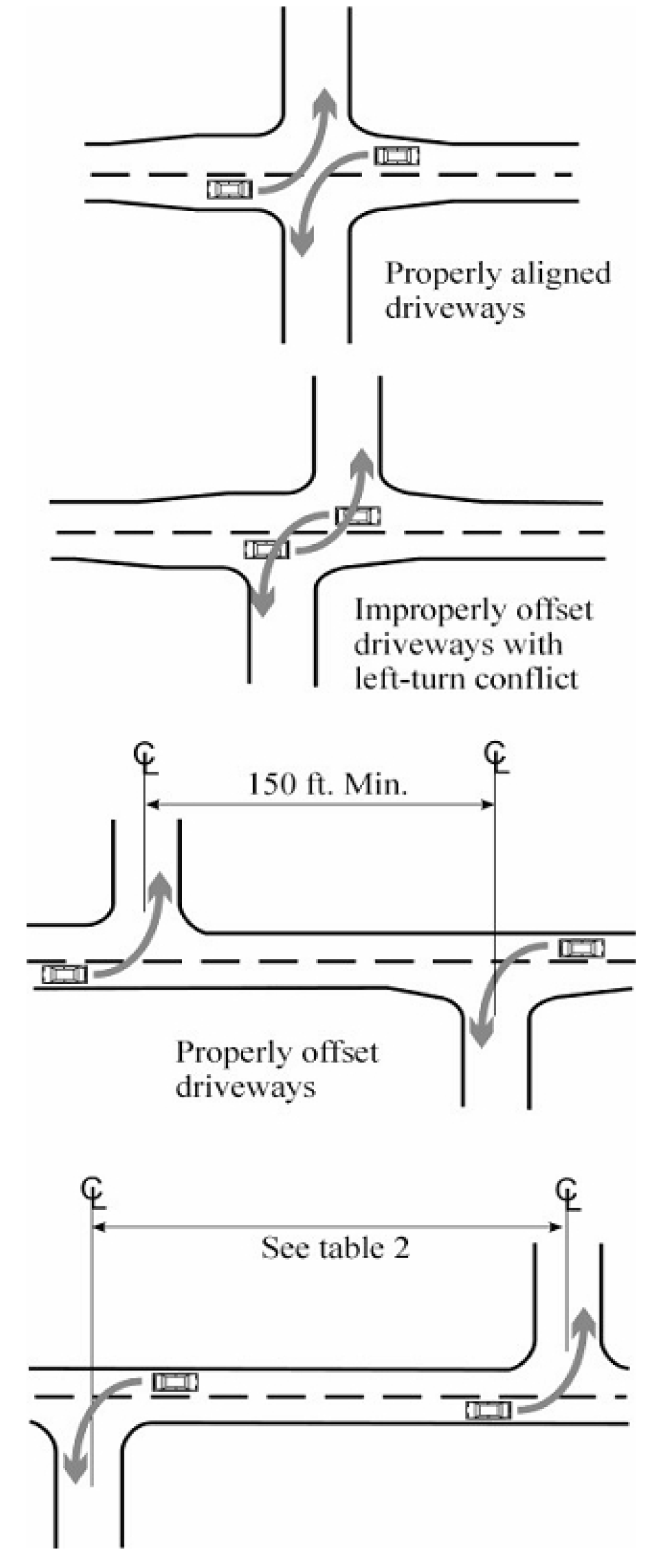
Access points shall be aligned with driveways on the opposite side of the street or offset the distance as indicated in Table 26.
8)
Minimum spacing of access points from intersections shall be in accordance with Table 27 (measured from pavement edge to pavement edge).
9)
Where direct access consistent with the various standards above cannot be achieved, access shall be via a shared driveway or service drive or side street. In cases where access is from the side street, the access point must be located as far from an intersection as feasible.
b.
Sight Distance. Driveways shall be located to provide safe sight distance or as determined by the applicable road agency.
c.
Public Facilities in Right-of-Way. No driveway shall interfere with municipal facilities such as street light or traffic signal poles, signs, fire hydrants, cross walks, bus loading zones, utility poles, fire alarm supports, drainage structures or other necessary street structures.
d.
Shared Commercial Driveways, Frontage Roads and Service Drives. Shared commercial driveways, frontage roads or rear service drives connecting two or more lots or uses shall be required in instances where the Planning Commission and MDOT determines that reducing the number of access points will have a beneficial impact on traffic operations and safety. In particular, service drives shall be required where recommended in a sub-area master plan; near existing traffic signals or near locations having potential for future signalization; where service drives may minimize the number of driveways; and along segments with a relatively high number or crashes or limited sight distance. Frontage roads or service drives shall be constructed in accordance with the following standards:
1)
Service roads shall generally be parallel or perpendicular to the front property line and may be located either in front of, adjacent to or behind principal buildings. In considering the most appropriate alignment for a service road, the Planning Commission and MDOT shall consider the setbacks of existing buildings and anticipated traffic flow for the site.
2)
The service road shall be within an access easement permitting traffic circulation between properties. This easement may be reviewed by MDOT for location and approved by the Township and recorded with the Saginaw County Register of Deeds. The required width shall remain free and clean of obstructions unless otherwise approved by the Planning Commission. Each property owner shall be responsible for maintenance of the easement and service drive.
3)
Service drives and frontage roads shall be set back as far as reasonably possible from the intersection of the access driveway with the public street. A minimum of twenty (20') feet shall be maintained between the public street right-of-way and the pavement of the frontage road with a minimum of sixty (60') feet of throat depth provided at the access point measured between the public street right-of-way and the pavement of the parallel section of the frontage road.
4)
Service roads shall have a minimum pavement width of twenty-four (24') feet and be constructed of a base, pavement and curb with gutter that is in accordance with public street standards. The Planning Commission may modify these standards based upon site conditions, anticipated traffic volumes and type of truck traffic.
5)
The service road is intended to be used exclusively for circulation. The Planning Commission may require the posting of "no parking" signs along the service road. One-way roads or two way roads constructed with additional width for parallel parking may be allowed on the side of the road closest to the building if it can be demonstrated through site plan review that parking along the service road will not significantly affect the capacity, safety or operation of the service road.
6)
The site plan shall indicate the proposed elevation of the service road at the property line so that the Township can maintain a record of all service road elevations and their grades can be coordinated with future developments.
7)
The alignment of the service drive can be refined to meet the needs of the site and anticipated traffic conditions, provided the resulting terminus allows the drive to be extended through the adjacent site(s). This may require use of aerial photographs, property line maps, topographic information and other supporting documentation.
8)
In cases where a shared access facility is recommended but is not yet available, temporary direct access may be permitted provided the plan is designed to accommodate the future service drive and a written agreement is submitted that the temporary access will be removed by the applicant when the alternative access system becomes available. This may require posting of a financial performance guarantee.
9)
With the redevelopment of existing sites where it is not possible to develop separate service drives, the Planning Commission and MDOT may instead require a drive connecting parking lots.
(Ord. No. 08-Z-05, 1-14-2009, eff. 2-13-2009)
SECTION 13.6. - MODIFICATION OF ACCESS STANDARDS.
Modifications by Planning Commission and MDOT. Given the variation in existing physical conditions along the corridors, modifications to the spacing and other standards above may be permitted by the Planning Commission and MDOT as part of the site plan review. Standards to take into account when considering a modification include practical difficulties that may exist on the site that make compliance with the standards of this ordinance unreasonable which may include site distance limitations, topography, drain or water bodies, wetlands, building location to right-of-way and lot size and dimensions and the extent to which existing off site access points make it impractical to fully comply with the standards. Such modification shall provide reasonable access that will not impair safety and is not simply for the convenience of development.
The decision of the Planning Commission may be appealed to the Zoning Board of Appeals. In consideration of this variance, the Board shall apply the standards above
(Ord. No. 08-Z-05, 1-14-2009, eff. 2-13-2009)
SECTION 13.7. - M-46 CORRIDOR PLAN REVIEW CHECKLIST.
The following checklist may be used by staff, Zoning Administrator or whoever receives applications to discuss procedures with potential applicants:
a.
Is the subject site located within the M-46 Corridor Access Management Plan study area?
b.
Has the most recent plan been submitted to MDOT contact person for their review and comments?
c.
Has the applicant been made aware of the special recommendations and standards?
d.
Is the site within an area where specific access recommendations were provided in the M-46 Corridor Access Management Plan? If so, provide the applicant with a copy.
e.
Does the site plan or submittal illustrate all of the additional information on other existing access points and adjacent lot configurations so compliance with the standards can be determined?
f.
Can the site meet the spacing standards between access points?
g.
Is the number of access points the minimum needed to provide reasonable access to the site?
h.
Is there a potential to provide an alternative shared access system?
i.
Is the access point properly aligned with or spaced from existing driveways or the location where driveways can be expected in the future?
j.
Has information on sight distance been provided?
k.
Is there a need for a traffic impact study to evaluate the impacts and determine if changes to the site design or road system are needed?
l.
Should other communities along the M-46 corridor be informed of the proposal (i.e. is the project large enough that it will have a major impact?)
m.
Is there a reason to request a meeting with MDOT to discuss and address access issues prior to review by the Planning Commission?
FIGURE 16 DRIVEWAY SPACING MEASUREMENTS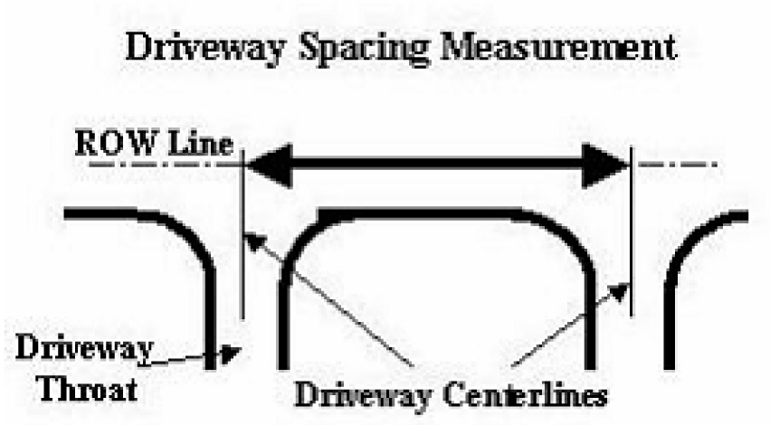
TABLE 25 MAXIMUM DRIVEWAY SPACING SAME SIDE OF ROAD
TABLE 26 MINIMUM OPPOSING DRIVEWAY OFFSET
TABLE 27 MINIMUM DRIVEWAY SPACING FROM INTERSECTION
* Unless greater spacing is required by MDOT, SCRC or required to meet other standards here.
** Greater spacing may be required based upon the posted speed of the road and the spacing distances required.
(Ord. No. 08-Z-05, 1-14-2009, eff. 2-13-2009)
FIGURE 17 DRIVEWAY SPACING FROM INTERSECTION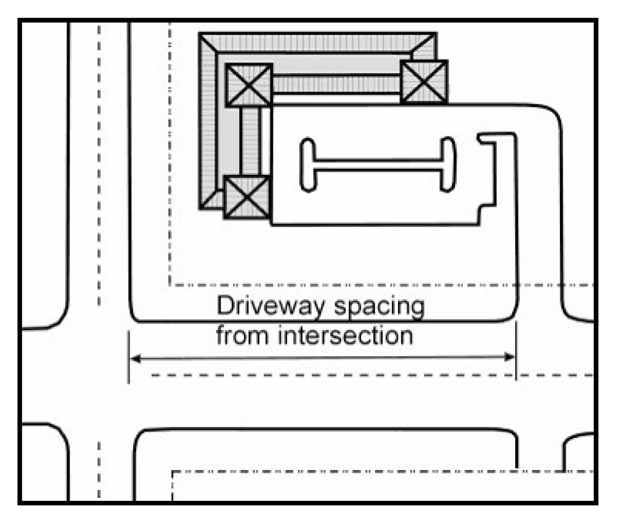
FIGURE 18 SERVICE DRIVE SETBACK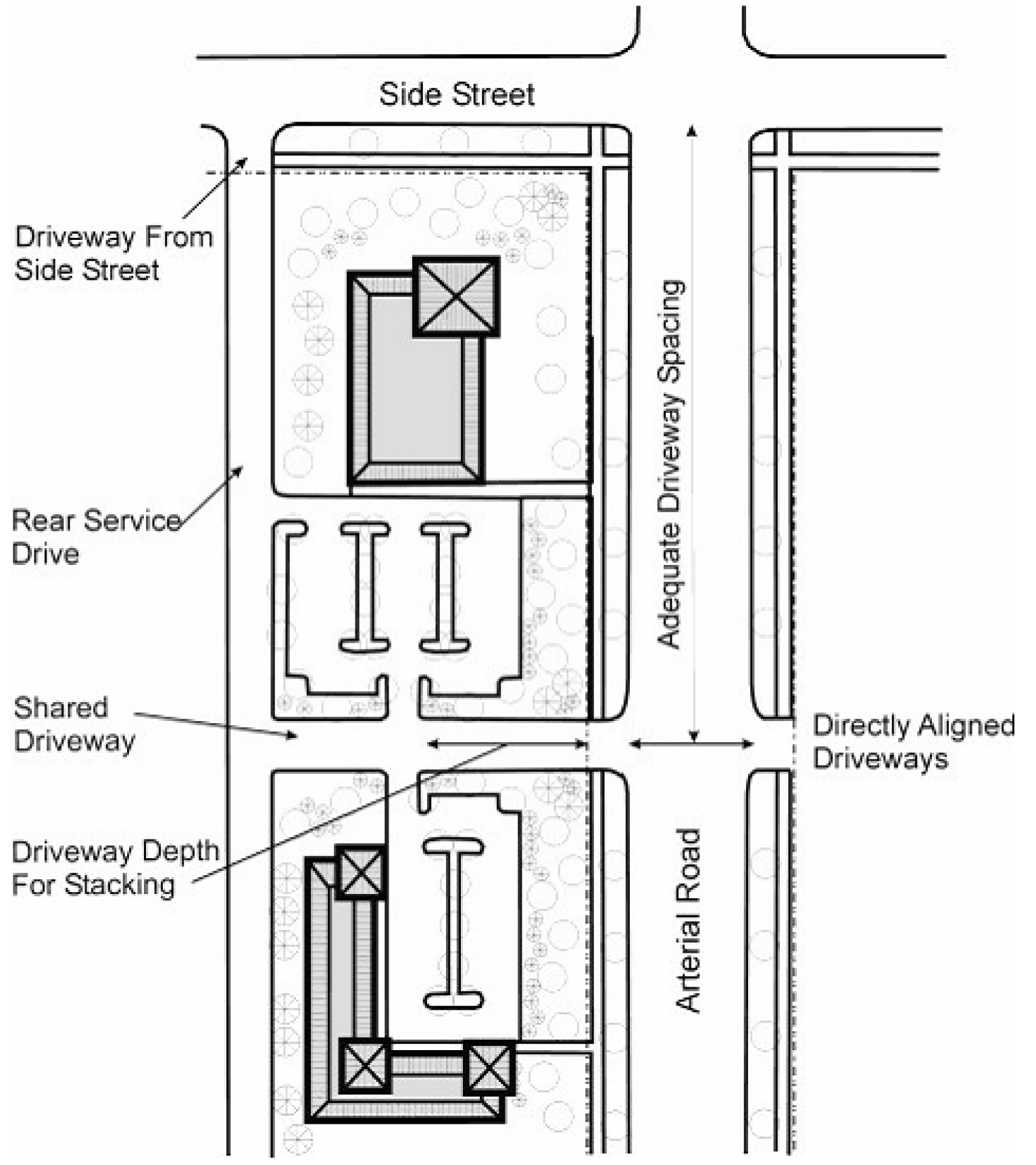
FIGURE 19 FRONTAGE ROAD SETBACK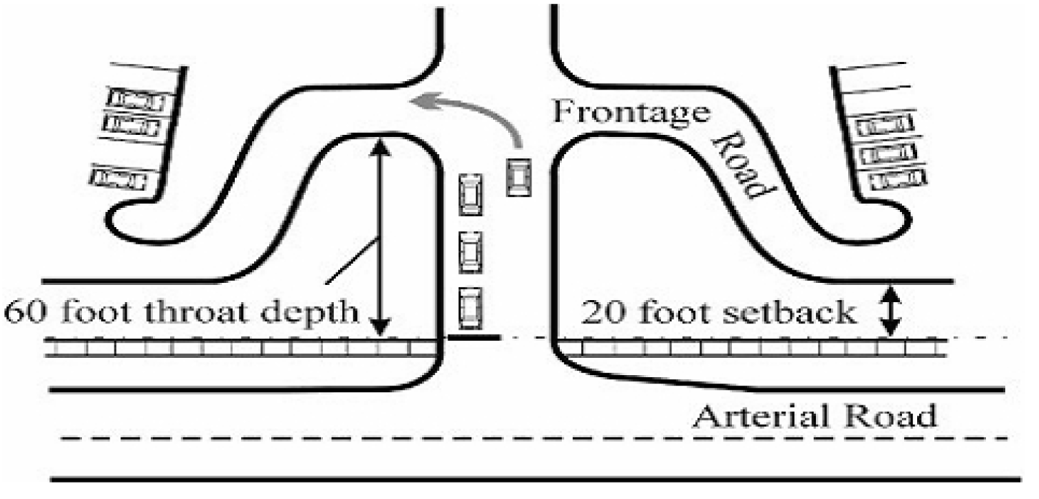
FIGURE 20 DRIVEWAY ALIGNMENT AND OFFSET