
Thomas Township City Zoning Code
CHAPTER 9
AGRICULTURAL DISTRICTS
SECTION 9.1.- A-1 PRIMARY AGRICULTURE AND CONSERVATION DEVELOPMENT DISTRICT.
TABLE 14—A-1 PRIMARY AGRICULTURE AND CONSERVATION DEVELOPMENT DISTRICT USES
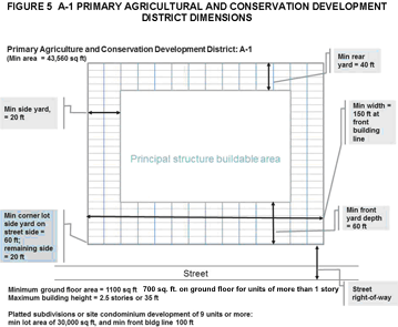
(A)
Farm Manager Dwelling:
0 Bedrooms=600 sq. ft.
1 bedroom=800 sq. ft.
2 bedrooms=1,000 sq. ft.
3 bedrooms=1,200 sq. ft
4 bedrooms=1,400 sq. ft.
(Ord. No. 13-Z-03, § 1, 10-7-2013, eff. 11-15-2013; Ord. No. 15-Z-06, § 1, 2-1-2016, eff. 3-8-2016; Ord. No. 18-Z-04, 6-4-2018, eff. 7-7-2018; Ord. No. 18-Z-03F, 8-6-2018, eff. 9-17-2018; Ord. No. 20-Z-05, § 1, 10-5-2020, eff. 11-9-2020)
SECTION 9.2. - A-2 GENERAL FARMING, OPEN SPACE, WOODLOT, AND CONSERVATION DEVELOPMENT DISTRICT.
TABLE 15—A-2 GENERAL FARMING, OPEN SPACE, WOODLOT, AND CONSERVATION DEVELOPMENT DISTRICT
Uses By Right
• Accessory use
• Cemeteries, public and private
• Conservation areas and structures, public and private
• Farming, forestry, field crops, orchards, horticulture, tree nurseries, livestock raising, animal feeding operations,
• Home occupations
• Institutions: Educational, Religious
• Parks and recreation facilities, public and private
• Roadside stands selling products grown by the property owner
• Single-family dwelling
• Farm Manager dwelling.
• Specialized farming including raising of small animals and livestock
• Yard, rummage or garage sale
• On Site Wind Energy System (Building Mounted Wind Turbine; Small Tower Wind Turbine).
Uses By Special Permit
• Airports and commercial landing strips
• Drilling, operating and maintenance of wells
• Golf courses, country clubs and driving ranges
• Grain and seed elevators and sales
• Greenhouses and nurseries selling retail on premises
• Institutions: Social
• Kennels, veterinary hospitals, animal clinics
• Livestock auction yards
• Open Air Business
• Production of fur-bearing animals for profit
• Quasi-public uses
• Riding stables
• Sand, gravel or clay pits and quarries
• Seasonal labor housing complex associated with agricultural enterprise
• Sewage treatment and disposal installations
• Shooting ranges
• Solar farms
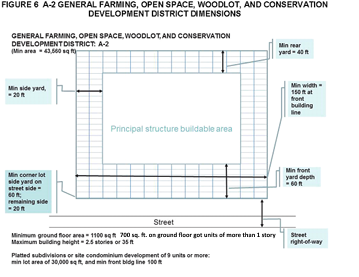
(A)
Farm Manager dwelling:
0 bedrooms=600 sq. ft.
1 bedroom=800 sq. ft.
2 bedrooms=1,000 sq. ft.
3 bedrooms=1,200 sq. ft.
4 bedrooms=1,400 sq. ft.
(Ord. 97-Z-03, 11-3-1997, eff. 12-12-1997; Ord. No. 14-Z-01, § 1, 4-7-2014, eff. 5-19-2014; Ord. No. 15-Z-06, § 2, 2-1-2016, eff. 3-8-2016; Ord. No. 18-Z-04, 6-4-2018 eff. 7-7-2018; Ord. No. 18-Z-03G, 8-6-2018, eff. 9-17-2018; Ord. No. 20-Z-04, § 1, 10-5-2020, eff. 11-9-2020)
SECTION 9.3. - CONSERVATION DEVELOPMENT REGULATIONS AND STANDARDS.
a.
Intent and Purpose: Because of accelerating suburban development in agricultural and rural areas of Thomas Township, a need to preserve the Township's pristine features has been created. The provisions set forth encourage innovative housing developments through permanent dedication of open space and a planned reduction of individual lot area requirements. By grouping dwellings on a limited portion of a development property, the resulting effect is the preservation of much of the rural lands and natural features. An enhanced living environment is then created which will help retain and enhance the rural character found in the Township.
b.
Establishment of Overlay District: Conservation development districts are herein established as overlay districts. The conservation development overlay districts are described on the Township Zoning Map as "A-1 Primary Agriculture and Conservation Development District" and "A-2 General Farming, Open Space, Woodlot, and Conservation Development District". The overlay district's open space significance is based upon a combination of factors including soil type, topography, existing vegetation and habitat, historic use of land, size of parcel, use of land for agricultural purposes and character of surrounding area.
c.
Permitted Uses:
1)
Single-Family Use: Single-family residential dwellings (including site condominium) are permitted having a minimum of one thousand one hundred (1,100) square feet of living area.
a)
Setbacks: The following design parameters will be used to establish setbacks.
i.
Front and rear yard setbacks may be staggered to provide for maximum variety in the size of such yards.
ii.
Exception: If a garage is to be front-loaded from the street, the minimum front yard setback from the street right-of-way or street easement shall be twenty-six feet (26').
iii.
The minimum distance between dwellings shall be twelve feet (12'), six feet (6') from property lines.
b)
Lot Width: The following design parameters will be used to establish lot widths:
i.
Lots not served by public sanitary sewer shall have a minimum of one hundred feet (100') of frontage at the front building line.
ii.
Lots served by public sanitary sewer shall have a minimum of ninety feet (90') of frontage at the front building line.
iii.
Lots served by public water and by public sanitary sewer shall have a minimum of eighty feet (80') of frontage at the front building line.
2)
Residential Accessory Uses: For every single-family residential dwelling, two (2) accessory buildings shall be permitted per parcel. One accessory building may be constructed up to one hundred fifty (150) square feet in size, and one accessory building may be constructed up to six hundred (600) square feet in size.
a)
Side wall height may not exceed ten feet (10').
b)
Overall height may not exceed seventeen feet (17') to the peak.
c)
Setbacks within a conservation development for residential accessory buildings shall be ten feet (10') from a side property line and ten feet (10') from the rear property line.
3)
Incidental Accessory Uses: Accessory uses incidental to the principal permitted uses include recreational activities, which are passive and occur on common open space lands only, such as soccer fields, softball fields and similar type fields, including parks and boat launches.
4)
Agriculture Accessory Uses: Agriculture, horticulture or floriculture accessory use buildings, livestock raising operations and animal stables are allowed in open space areas if approved during site plan review. Permitted uses within dedicated open space shall be required to meet the following requirements:
a)
Side wall height may not exceed twenty-five feet (25').
b)
Overall height may not exceed forty feet (40') to the peak.
c)
The setback from a side property line shall be seventy-five feet (75').
d)
The setback from a rear property line shall be twenty-five feet (25').
e)
The setback from a front property line or right-of-way shall be seventy-five feet (75').
f)
Any accessory structure(s) or building(s) constructed in open space areas shall not exceed, in the aggregate, one percent (1%) of the open space area.
d.
General Development Standards:
1)
Ownership and Control: A proposed conservation development shall be under single or limited ownership control, such that a single person or entity has proprietary responsibility for the completion of the development. The applicant shall provide documentation of ownership or control in the form of agreements, contracts or covenants that indicate the development will be completed as proposed.
2)
Density Standards:
a)
Number Of Dwellings:
b)
The total number of residential dwelling units permitted in a conservation development shall be determined by submitting a limited detail conventional subdivision plan identifying the lots and buildable lands using the underlining A-1 or A-2 lot size standards.
c)
The maximum number of lots allowed under the Conservation Development Ordinance is the same as the number allowed in a conventional subdivision plan, not including additional lots allowed due to lot credits. In a conservation development each lot is smaller, according to the chart in Example 1 hereof. Once additional lots allowed are computed using the credits, the conservation development site plan may be established for review by the Planning Commission.
d)
The Planning Commission shall review the limited detail conventional subdivision plan during the same meeting that the proposed new conservation development site plan is reviewed, this will ensure no delay during the review process.
e)
In no case shall the maximum density specified for the zoning district in which the conservation development is located, be increased by more than the bonus percentage credit.
3)
Lot Sizes: Lots not served by public or common sanitary sewer shall have a minimum lot area of fifteen thousand (15,000) square feet. Lots served by public or common sanitary sewer shall have a minimum lot area of twelve thousand (12,000) square feet. Lots served by public water and by public or common sanitary sewer shall have a minimum lot area of ten thousand (10,000) square feet.
TABLE 16 CONSERVATION DEVELOPMENT DISTRICT - LOT SIZES
e.
Credits:
1)
Density Standards Credit: The total number of dwelling units permitted in a conservation development shall be determined as explained in the density standards, and in the following bonus percentage increase given for the following credits;
2)
Shoreline Credit: To encourage preservation of river and stream areas and to provide an incentive for property owners to incorporate the areas surrounding water bodies into an open space network, a shoreline credit shall be permitted if the following requirements are met:
a)
Step 1: One additional lot may be added to the conservation development for each five hundred (500) lineal feet of shoreline protected.
b)
Step 2: A minimum of one hundred feet (100') of open space must be created along the shoreline that is protected subject to permanent open space dedication.
c)
Step 3: All provisions of the Flood Plain Ordinance must be complied with when considering this credit.
3)
Pathway Credit: To encourage the development of a pathway within the open space area, a pathway credit will be given to a developer who completes the following steps:
a)
Step 1: A credit of one additional lot shall be given if a pathway is created and installed. It must be installed prior to the sale of any lot within the development.
b)
Step 2: The pathway is no less than five feet (5') wide, has a raised base so that it drains properly, is covered by a surface other than grass or dirt, such as wood chips, pavement or stone.
c)
Step 3: All pathways are significant in length as determined by the Planning Commission, in order to take advantage of the available open space. The pathway should be circular in nature going around the development and connecting developments when feasible.
4)
Recreation Area Credit: To encourage the development of parks, playgrounds or recreational fields, a recreation area credit will be given to a developer who completes the following steps:
a)
Step 1: A credit of one additional lot shall be given if a recreation area is developed. The recreation area must be shown on brochures and must be staked out prior to the sale of any lot within the development so that potential buyers are aware of its location.
b)
Step 2: The recreation area must include one of the following items: 1) a baseball, soccer, football or similar field; 2) a picnic area with tables and park benches; 3) other nonmotorized recreation areas that are approved by the Planning Commission.
c)
Step 3: All recreation areas will be significant in overall size and will be beneficial to the residents as determined by the Planning Commission, in order to take advantage of the available open space.
d)
Step 4: These recreation areas may be open to the public or limited to the use of residents living within the conservation development depending upon how the open space is restricted from further development. The means to allow public access or restricted access must be in the master deed of the development.
5)
Open Space Area Credit: To encourage the preservation of open space, an open space area credit will be given to a developer who can show a significant increase in open space area preservation. One of the following two (2) options must be met:
a)
Option 1: A credit of one additional lot shall be given if a development preserves sixty percent (60%) of the determined buildable area as open space within a development.
b)
Option 2: A credit of two (2) additional lots shall be given if a development preserves seventy percent (70%) of the determined buildable area as open space within a development.
c)
Condition: All computations to determine if an open space area credit will be given shall be done with the additional lot(s) added into the development prior to making the computation to determine if credit should be given.
f.
Open Space Standards:
1)
Areas Not Considered Open Space: The following areas shall not be calculated as dedicated open spaces:
a)
Open space shall not include areas devoted to public or private road rights of way or any land that has been or is to be conveyed to a public agency for utilities.
b)
Any area devoted to county drain easements.
c)
All existing surface water bodies and regulating wetlands.
2)
Calculating Open Space: Except as noted above, any undeveloped land area within the boundaries of the parcel may be included as required open space.
3)
Use Of Open Space: All land within a development that is not devoted to a residential unit, an accessory use, vehicle access, vehicle parking, a roadway, approved land improvement or is not considered "open space" as defined above shall be considered dedicated open space and shall be set aside as common land for recreational, conservation and agricultural uses and preserved in an undeveloped state. Further subdivision of open space lands, or their use for other than recreation, conservation or agriculture shall be prohibited.
4)
Minimum Open Space Percentage: Dwelling units, including those allowed through bonus provisions and/or credits, shall be grouped so that open space within a development is at least fifty percent (50%) of the total area of buildable land.
5)
Open Space Access: Pedestrian access points to open space shall be required between rows of six (6) or more lots, and at the end of culs-de-sac. Access points must be of common ownership and a minimum of six feet (6') in width. The Planning Commission shall determine if additional access points are necessary for pedestrian access to open areas or if a modification of this standard is necessary.
6)
Maintenance Vehicle And Open Space Access: Conservation developments shall provide maintenance vehicle access to interior common areas that require mowing or tilling.
7)
Waterway Buffering: All dwellings and accessory structures shall be no less than one hundred feet (100') from any lakes, ponds, rivers and streams. Only with approval of the Planning Commission may a roadway be placed within this buffer area and efforts should be made to eliminate any encroachment when possible.
8)
Preservation of Open Space: Open space shall be set aside by the developer through an irrevocable conveyance that is acceptable to the Township. All forms of protecting open space within a conservation development shall be subject to the review of the Township Attorney and all transfers of property to the Township are subject to approval by the Township Board. Forms of dedicating open space may include:
a)
A conservation easement.
b)
Covenants that run perpetually with the land. Use of dedicated open space may be restricted to dwelling owners within the development.
c)
Transfer of deed to Township, County or State ownership with Township Board approval. The open space must be suitable for parks, ball fields or public access to waterways and for a boat launch. The transferred dedicated open space will be considered public lands.
d)
Two (2) forms of the above mentioned preservation options may be used together if a portion of a parcel is being deeded to the Township, County or State and a portion of a parcel is being retained for the development's dwelling owners to use exclusively as covenant protected open space.
9)
Conveyance Standards: Such conveyance shall assure that the open space will be protected from all forms of development, except as allowed under this ordinance and shown on an approved site plan and shall never be changed to another use. Such conveyance shall:
a)
Indicate the allowable use(s) of the dedicated open space with site plan approval.
b)
Require that the dedicated open space be maintained by parties who have an ownership interest in the open space.
c)
Provide standards for scheduled maintenance of the open space.
d)
Be recorded on every deed of parcels within the development.
10)
Trees In Open Spaces: Three (3) trees no less than two feet (2') tall and twenty-five (25) trees not less than ten inches (10") tall, marked by a planting stick thirty six inches (36") tall, must be planted within the open space area for every residential building lot created within the open space development. The location of the tree plantings and type of tree to be planted is subject to Planning Commission approval. All tree plantings shall be on dedicated open space areas only. No more than fifty percent (50%) of the same species of tree may be planted within the developments open space area. If recreation areas or farm fields are developed within the open space, the tree plantings may be located around the perimeter of the fields or in groups.
TABLE 17 NUMBER OF TREES REQUIRED IN OPEN SPACE AREA PER LOT DEVELOPED
a)
An inspection of the required open space area and tree plantings shall be required by the developer a minimum of twelve (12) months after initial planting. Any tree plantings that died or have been removed must be replaced.
b)
The Planning Commission may require a performance bond or case deposit, equal to the cost of the trees and their installation. The proceeds of this deposit shall be returned to the developer only after a written report from the developer is presented to the Township stating the findings of the inspection. The Township may inspect the site to verify all findings.
11)
Installation Delay: If seasonal conditions such as snow and ice do not allow for the planting of trees in open space areas or the installation of sidewalks along open space, a delay in planting or installation may be granted.
a)
The delay may only be granted until May 31, at which time planting of said trees and/or installation of sidewalks must be commenced as determined by the Township Building Inspector.
b)
A performance bond or other acceptable monetary assurance will be required to ensure the required installation of sidewalks and/or tree plantings is completed. The Township Engineer shall determine the amount of monetary assurance to be held by the Township until the required work is completed.
c)
If after May 31, the required sidewalk installation or tree plantings have not commenced as determined by the Building Inspector, the Township may use the deposited funds to complete the required work.
d)
All additional funds necessary to complete said work above the deposited amount will be charged to the parcel owner(s) and if necessary a lien will be placed on the parcel and required funds may be collected from the property tax paid on said parcel(s).
g.
Housing Development Standards:
1)
Dwelling Placement: Dwelling units shall be carefully located and designed. Dwelling placement shall be planned to screen homes from off-site vantage points, away from environmentally sensitive areas, existing agricultural uses and away from areas subject to land management practices that will cause dust, noise, smoke, odors or similar problems.
2)
Residential Tree Plantings: All residential lots shall have three (3) trees planted in the front yard area a minimum of six feet (6') high prior to obtaining an occupancy permit.
3)
Sanitary Sewer: If sanitary sewer or public water is provided within the development, all provisions for the review and approval by the Township must be completely followed. If there is a public sanitary sewer within five hundred feet (500') from any portion of the proposed development, the sanitary sewer shall be provided according to Township requirements.
4)
Water: If there is an existing or extendible public water supply within five hundred feet (500') from any portion of the proposed development, the water shall be provided according to Township requirements.
5)
Lot Drainage: All lots shall have lot drainage that shall comply with all requirements of the Storm Water Management Ordinance. Open space area undisturbed may not be required to be evaluated for storm water review.
6)
Septic System: If not served by public sanitary sewer, the following on-site septic system procedure may be followed upon Township approval:
a)
In order to meet the Saginaw County Health Department and Department of Environmental Quality's requirement for lot size, a portion of the open space area may be used for septic system lot size computation and if necessary for its installation.
b)
The open space area used for septic system computation and installation must be restricted to the installation of an individual dwelling septic system only. The following conditions must be met prior to Township Planning Commission approval of any such system:
i.
The development is not served by public or common sanitary sewer.
ii.
The septic system must be placed as close as possible to the dwelling using the system.
iii.
The County Health Department and all State required installation details must be followed.
iv.
Open space area used as part of the required septic system computation may only be used once.
v.
The site plan submitted for review by the Township Planning Commission must show the area to be used in the septic system calculation.
vi.
The parcel owner must remove the septic system from the open space area if public sanitary sewer is connected to the dwelling.
vii.
Open space areas having septic systems on them may not in any way be turned over to the Township as Township property.
viii.
The open space area used for the septic system may not be maintained as lawn for any dwelling owner.
ix.
If the open space is farmed, no plantings shall be allowed over the septic system.
x.
No trees may be planted over a septic system in open space areas.
c)
Prior to Construction: Prior to any residential construction within a conservation development, all roadways, drainage and utilities must be installed within one year of the first home start. All pathways must be installed prior to any residential construction.
d)
Signage: All proposed signage in the residential area shall be regulated as if it were zoned R-1.
h.
Sidewalk Standards: Sidewalk Requirements: The following provisions shall be used for the location and placement of required sidewalks within a conservation development:
1)
Sidewalks In Front of Dwellings: A five foot (5') wide sidewalk must be installed along the frontage of every dwelling. A minimum setback from the edge of the roadway of eight feet (8') is required unless approved by the Planning Commission. The sidewalk must be installed prior to obtaining an occupancy permit.
2)
Sidewalks Along Open Space: A five foot (5') wide sidewalk must be installed along the frontage of every residential dwelling and installed along at least one side of every roadway that has frontage on common open space area.
3)
Sidewalk Ramps: An approved sidewalk ramp to the roadway, meeting sidewalk ordinance standards must be installed at the end of all sidewalks stopping at common areas and a similar approved ramp must be located directly across the roadway to connect the sidewalks on opposite sides. All sidewalks must meet the specifications for sidewalk construction and maintenance found in the Thomas Township Sidewalk Ordinance. The Thomas Township Planning Commission shall have final approval of sidewalk location. The Planning Commission may require sidewalks on both sides of a roadway if it is determined to be necessary for public safety.
4)
Sidewalks along Public Roadways: Sidewalks within a conservation development must extend to the public roadway with an approved sidewalk ramp. Sidewalks are required along the frontage of any public roadway.
5)
Sidewalk Design: The site plan must show a cross section of required sidewalks showing the type of materials, sidewalk base and surface elevation in relation to the grade, all of which must meet the sidewalk construction standards found in the Township Sidewalk Ordinance. Sidewalks must be constructed to meet all requirements found in the Sidewalk Ordinance.
i.
Governmental Construction Authority Standards: Nothing in this ordinance shall be construed as prohibiting further construction or use of land by any government body for public purposes where consistent with the zones and regulation of this chapter.
j.
Private Roads.
1)
Access: Conservation developments shall have access to a public roadway by connection to another conservation development or by physical connection. Access to conservation developments shall be provided internally from roadways constructed within the proposed development. Any entrance or exit drive shall be located no closer than two hundred feet (200') from any existing street or road intersection as measured from the nearest right-of-way line.
2)
Internal Roads: Construction of private roads as a means of providing access and circulation is required within a conservation development. All roadways constructed shall provide adequate storm drainage systems, including necessary storm sewers, drain inlets, manholes, culverts and bridges and shall be required in all developments. The drainage requirements for each development shall be established by the Thomas Township Storm Water Management Ordinance. All roads designed for a conservation development must be approved by the Township Engineer and the Saginaw County Drain Commissioner, prior to construction. The following requirements must be established within all conservation development deed restrictions:
a)
A deed restriction to be placed on the project site that perpetually vests fee simple the land area in the parties adjoining the road and prohibits future transfer to the public, prohibits future lot splits.
b)
A deed restriction placed on each lot with a private road maintenance plan attached stating that only lot owners within the development shall pay for roadway maintenance and snow removal and that the Township shall not be responsible for any future improvements to the private road.
3)
Review Notice: Application, review and approval of a proposed private road shall follow the same procedures, as site plan review application with regards to notice and timing.
4)
Sealed Prints: Application for approval of a private road shall include a site plan sealed by a professional engineer showing:
a)
Lot Lines: Existing and proposed lot lines.
b)
Structures: The location of existing structures.
c)
Width Of Roads: The width and location of the private road easement.
d)
Road Materials: A cross section of the proposed road, showing the types of material the road base and surface will consist of.
e)
Utility: Utility plans including the location, size and capacity of storm water drainage systems to comply with the Storm Water Management Ordinance, sewer or septic systems, water lines or private well locations and private utilities such as telephone, electrical and cable service.
f)
Driveways: Proposed locations of driveways off the private road to any recreational fields.
g)
Right-of-way: Any existing or proposed structures, trees or other obstructions within the proposed right-of-way.
h)
Land Division Ordinance: All division of land shall be in compliance with the Land Division Ordinance.
i)
Traffic Calming: All private roads within a conservation development shall use significant traffic calming designs that will reduce speeds naturally. The use of green islands and curved roads to slow traffic naturally will be required on all roads over six hundred feet (600') in length.
5)
Standards: The proposed private road shall meet the following standards:
a)
The minimum right-of-way width shall be fifty feet (50'), provided that an applicant can request a reduction in right-of-way width in order to protect natural features provided that in no case may the right-of-way is less than forty feet (40').
b)
All roads shall be paved with bituminous asphalt or concrete and shall have a base design meeting the standards found in the "Saginaw County Road Commissions Procedures, Standards and Specifications for Plat Development" handbook. The following shall be complied with:
i.
If bituminous is used, the private road shall be constructed meeting the rural cross section design for a typical concrete all season road as outlined in the handbook.
ii.
If concrete is used, the private road shall be constructed meeting the rural cross section design for a typical concrete all season road as outlined in the handbook.
iii.
Only the width of the bituminous or concrete surface as shown in the handbook may be narrowed to three feet (3'), nothing less will be allowed to ensure adequate emergency vehicle access.
c)
The maximum grade within one hundred feet (100') of an intersection shall be three percent (3%).
d)
No fence, wall, sign, screen or any planting shall be erected or maintained in such a way as to obstruct vision between a height of three feet (3') and ten feet (10') within the triangular area formed by the intersection of a road right-of-way line and a private road right-of-way line and a line connecting two (2) points which are located on those intersecting right-of-way lines, thirty feet (30') from the point of intersection.
e)
In no instances may a cul-de-sac be over one thousand five hundred feet (1,500') in length from the main access road within the conservation development. The maximum number of dwellings in a group shall be determined by the Planning Commission.
f)
Any driveways off of a private road shall be at least forty feet (40') from the intersection of the private road right-of-way.
g)
Intersections of private roads with public roads shall be at an angle as close to ninety degrees (90°) as possible, but in no case shall it be less than eighty degrees (80°) or more than one hundred degrees (100°).
h)
Private roads shall meet the maintenance requirements as provided in the deed restrictions of the development.
i)
Parcels fronting on private roads shall meet the required conservation development lot size requirements.
j)
Unobstructed vertical clearance of not less than thirteen feet six inches (13'6") is required over all roads.
k)
Roads in excess of one hundred fifty feet (150') in length shall have an approved turnaround for emergency vehicles.
l)
Roadways shall remain unobstructed from locked gates, barriers, etc., at all times giving emergency vehicles access to the development.
m)
Access: No private road shall provide connection or access to industrial or commercial property.
n)
Inspection Fee: An inspection fee shall be paid by the developer prior to site plan review, so that the Township Engineer may ensure proper and safe private road construction. Fee to be set by Board resolution.
(Ord. 00-Z-01, 1-4-2000, eff. 2-3-2000; Ord. 03-Z-02, 10-6-2003, eff. 11-14-2003)
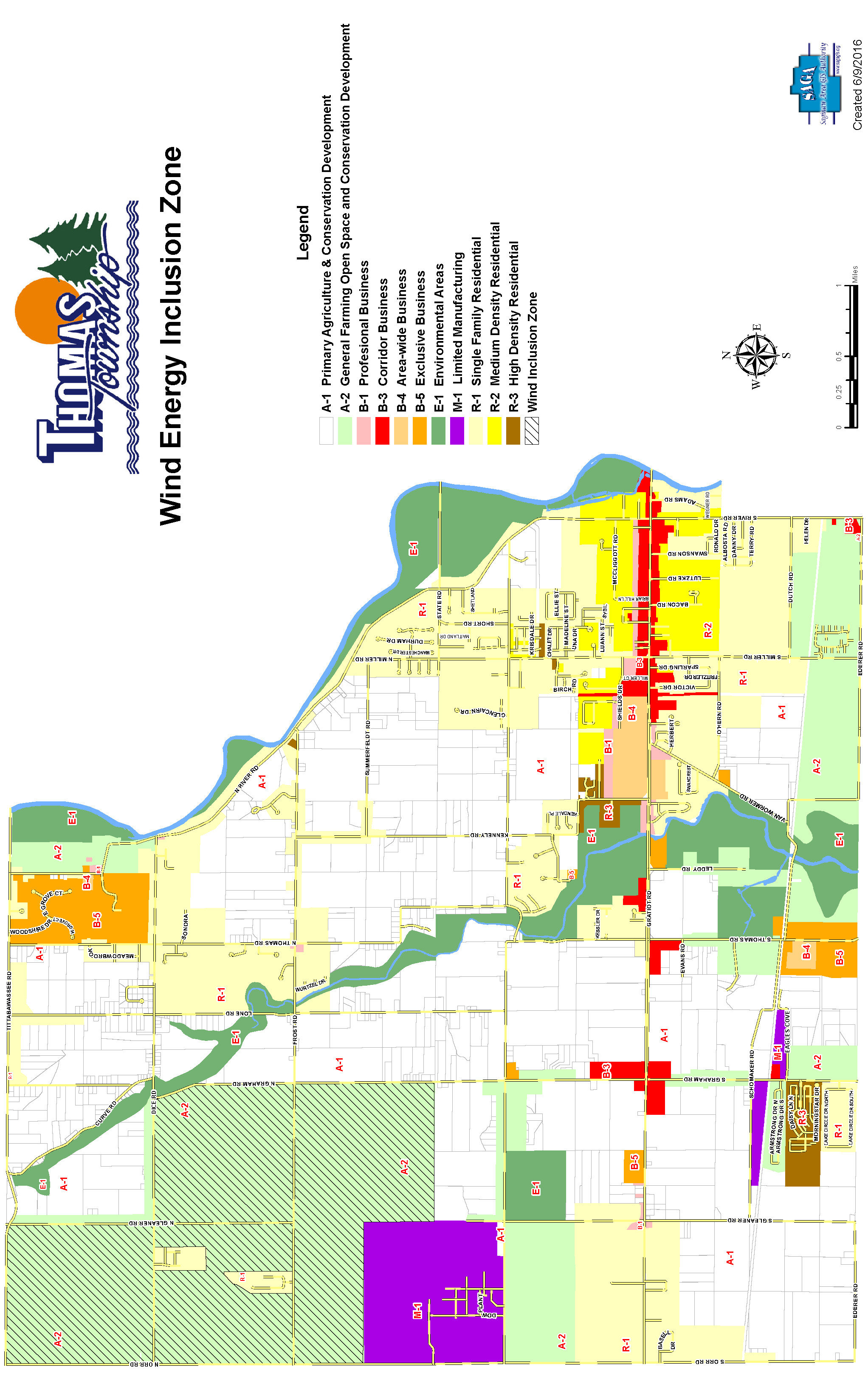
SECTION 9.4. - WIND INCLUSION ZONE.
A proposed Wind Inclusion Zone has been established in Thomas Township. The general location is West of North Graham and North of Geddes Roads shown on the Wind Inclusion Zone Map in specified areas zones A-2; General Farming, Open Space, Woodlot, and Conservation Development District.
Utility Grid Wind Energy Systems shall be considered a special land use in the specified wind zone areas as noted on such map.
(Ord. No. 18-Z-03B, 8-6-2013, eff. 9-17-2018)

