
Carmel City Zoning Code
ARTICLE 2
Zoning Districts
2.01 P1 District Intent, Permitted Uses and Special Uses
| Intent | Permitted Use | Special Exeption/Special Use |
| The purpose of this district is to provide for historic, museum, religious and charitable, and park and recreational uses and to protect the environment within this district by providing only for those uses and for compatible, less intensive urban land uses. | Agricultural Permitted Use
Institutional Permitted Use Recreational Permitted Use
Miscellaneous Permitted Use Temporary Permitted Use
Accessory Permitted Use
| Cultural/Entertainment Special Use
Education Special Use
Institutional Special Use
Miscellaneous Special Use
|
| * See Use-Specific Standards in Article 5, 5.47 through 5.74 for additional standards that apply |
2.02 P1 District Development Standards
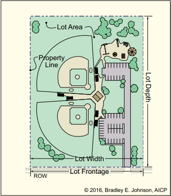 |  |  |  |
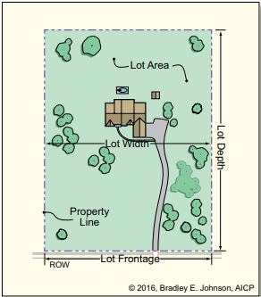
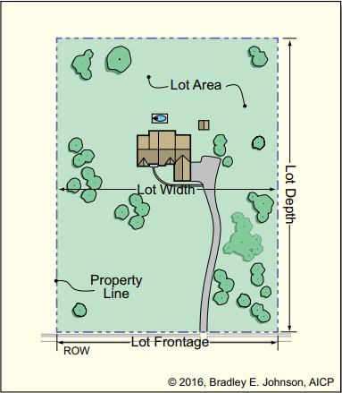
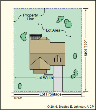
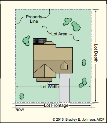
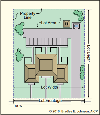
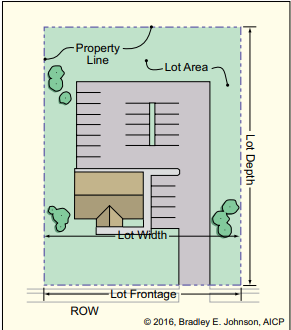
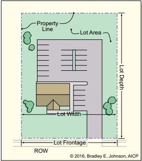
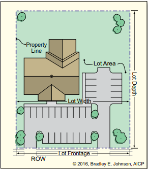
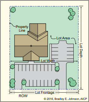
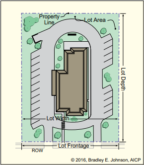
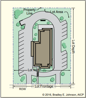
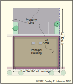
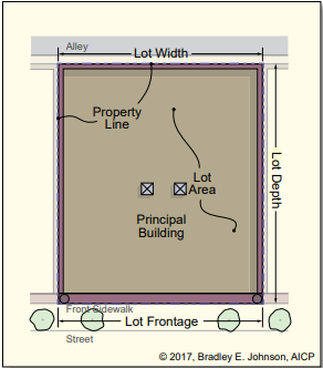
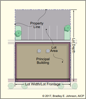
Minimum Lot Area
Minimum Lot Width
Minimum Lot Frontage
Maximum Lot Depth
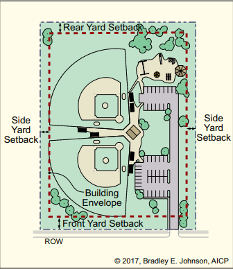
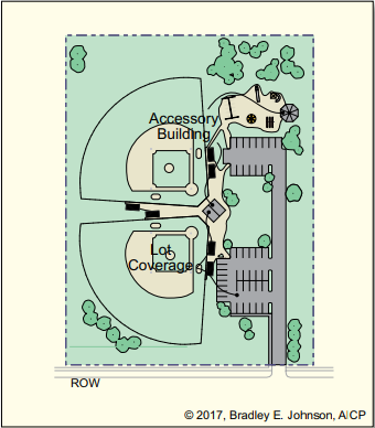
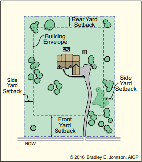
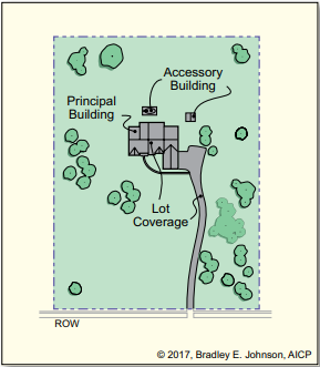
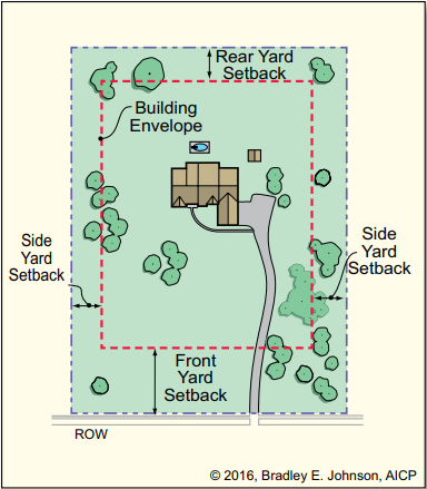
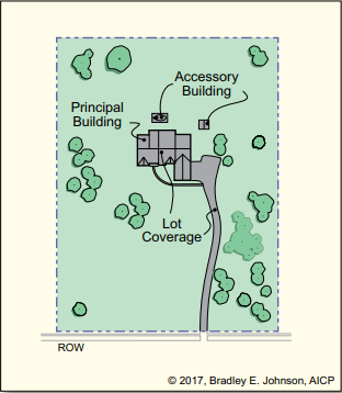
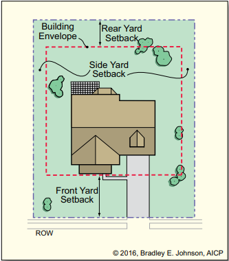
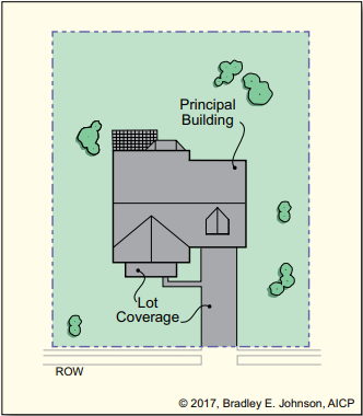
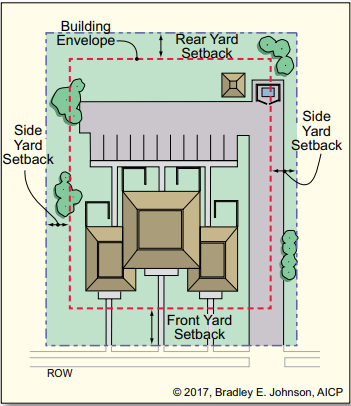
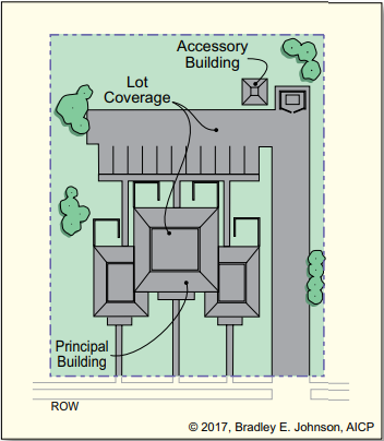
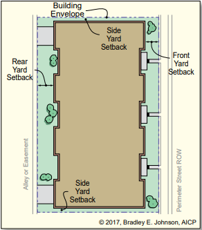
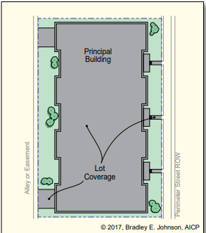
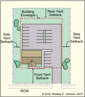
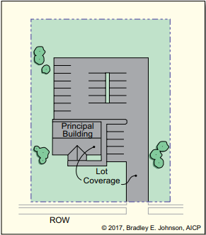
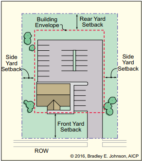
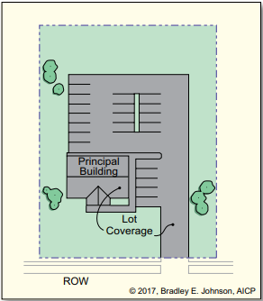
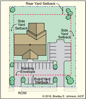
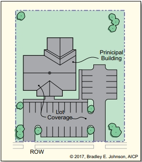
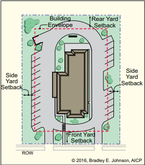
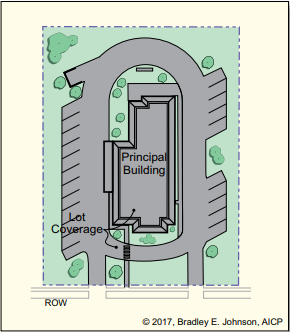
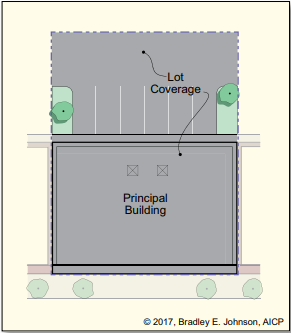
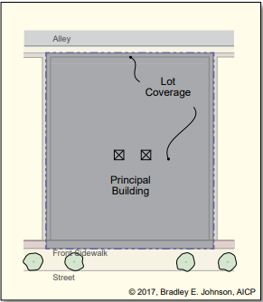
| Minimum Front YardSetbackMinimumSide YardSetbackMinimumRear YardSetback | Maximum Lot Coverage
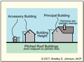
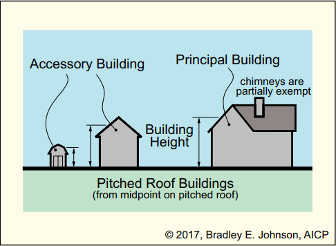
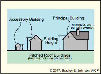
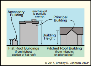
| Maximum Building Height
|
Additional Development Standards that Apply
Accessory Building and Use Density and Intensity Fence and Wall Floodplain Grading and Drainage Height Lot | Parking Recreational Vehicle Premises Identification Signs Telecommunication Facility Temporary Use and Structure | Use-Specific Utility Service Vision Clearance Weed and Solid Waste Wellhead Protection |
2.03 S1 District Intent, Permitted Uses and Special Uses
| Intent | Permitted Use | Special Exeption/Special Use |
| The purpose of the S1 District is to provide for the development of innovative residential environments in keeping with the rural character of this district, by providing for a development process that allows a high degree of flexibility in the design of single-family subdivisions. Further, it is the purpose of this district to provide for a development process that allows for more efficient use of the land through the introduction of open space and conservation lands within subdivisions. It is the intention of this district to protect remaining significant natural features within this district by placing an emphasis on less intensive urban land uses. | Agricultural Permitted Use
Institutional Permitted Use Recreation Permitted Use
Residential Permitted Use
Temporary Permitted Use
Accessory Permitted Use
| Agricultural Special Use
Education Special Use
Industrial Special Use
Institutional Special Use
Office Special Use
Recreational Special Use
Residential Special Exception
Miscellaneous Special Use
|
* See Use-Specific Standards in Article 5, 5.47 through 5.74 for additional standards that apply |
2.04 S1 District Development Standards
 |  |  |  |
Minimum Lot Area
Minimum Lot Width
| Minimum Front YardSetback
Minimum Aggregate of Side Yards
| Maximum Lot Coverage
Minimum Ground Floor Area Maximum Density
Maximum Principal Buildings per Lot
Development Plan Required
ADLS Required
| Maximum Building Height
|
Additional Development Standards that Apply
| Accessory Building and Use • AB-01 Architectural • AR-01 Density and Intensity • DI-01 Fence and Wall • FW-01 Floodplain • FP-01 Grading and Drainage • GD-01 Height • HT-01 Home Occupation • HO-01 Lot • LO-01 Manufactured Home • MH-01 Outdoor Storage • OS-02 | Parking Recreational Vehicle Premises Identification SetbackSigns • SI-01 Telecommunication Facility • TC-01 Temporary Use and Structure • TU-01 • TU-02 • TU-04 | Use-Specific • US-01 • US-02 • US-04 • US-05 • US-15 • US-16 • US-23 • US-26 • US-27 Utility Service • UT-01 Vision Clearance • VC-01 Weed and Solid Waste • WS-01 Wellhead Protection • WP-01 Yard • YS-01 • YS-02 |
2.05 S2 District Intent, Permitted Uses and Special Uses
| Intent | PermittedUses | Special Exception/SpecialUse |
| The purpose of this district is to provide for low-density single-family residential development in areas facing conversion from a rural-agricultural nature to a residential nature. The preservation of natural features and encouragement of open space residential land-use patterns in this district is intended to correspond to Suburban Residential in the Comprehensive Plan’s Land Classification Plan. | Agricultural Permitted Use
Institutional Permitted Use Recreation Permitted Use
Residential Permitted Use
Temporary Permitted Use
Accessory Permitted Use
| Agricultural Special Use
Education Special Use
Industrial Special Use
Institutional Special Use
Office Special Use
Recreational Special Use
Residential Special Exception
Miscellaneous Special Use
|
| * See Use-Specific Standards in Article 5, 5.47 through 5.74 for additional standards that apply |
2.06 S2 District Development Standards
 |  |  |  |
Minimum Lot Area
Minimum Lot Width
| Minimum Front YardSetback
Minimum Aggregate of Side Yards
Minimum Rear YardSetback
| Maximum Lot Coverage
Minimum Ground Floor Area Maximum Density
Maximum Principal Buildings per Lot
Development Plan Required
ADLS Required
| Maximum Building Height
|
Additional Development Standards that Apply
Accessory Building and Use • AB-01 Architectural • AR-01 Density and Intensity • DI-01 Fence and Wall • FW-01 Floodplain • FP-01 Grading and Drainage • GD-01 Height • HT-01 • HO-01 Lot • LO-01 • MH-01 Outdoor Storage • OS-02 | Parking • PK-01 • PK-02 • PK-03 Recreational Vehicle • RV-01 Premises Identification • PI-01 • SB-01 Signs • SI-01 Telecommunication Facility • TC-01 Temporary Use and Structure | Use-Specific • US-01 Utility Service • UT-01 Vision Clearance • VC-01 Weed and Solid Waste Wellhead Protection • WP-01 |
2.07 R1 District Intent, Permitted Uses and Special Uses
| Intent | PermittedUses | Special Exception/SpecialUse |
| The purpose of this district is to provide for low-density single-family residential development where adequate public facilities are available. The preservation of natural features and encouragement of open space residential land-use patterns in this district is intended to correspond to Suburban Residential in the Comprehensive Plan’s Land Classification Plan. | Agricultural Permitted Use
Institutional Permitted Use Recreation Permitted Use
Residential Permitted Use
Temporary Permitted Use
Accessory Permitted Use
| Education Special Use
Industrial Special Use
Institutional Special Use
Office Special Use
Recreational Special Use
Residential Special Exception
Miscellaneous Special Use
|
| * See Use-Specific Standards in Article 5, 5.47 through 5.74 for additional standards that apply |
2.08 R1 District Development Standards
 |  |  |  |
Minimum Lot Area
Minimum Lot Width
Public Utilities
| Minimum Front YardSetback Minimum Side YardSetback Minimum Aggregate of Side Yards
Minimum Rear YardSetback
| Maximum Lot Coverage
Minimum Ground Floor Area Maximum Density
Maximum Principal Buildings per Lot
Development Plan Required
ADLS Required
| Maximum Building Height
|
Additional Development Standards that Apply
Accessory Building and Use • AB-01 Architectural • AR-01 Density and Intensity • DI-01 Fence and Wall • FW-01 Floodplain • FP-01 Grading and Drainage • GD-01 Height • HT-01 • HO-01 Lot • LO-01 • MH-01 Outdoor Storage • OS-02 | Parking • PK-01 • PK-02 • PK-03 Recreational Vehicle • RV-01 Premises Identification • PI-01 • SB-01 Signs • SI-01 Telecommunication Facility • TC-01 Temporary Use and Structure • TU-01 • TU-02 • TU-04 | Use-Specific • US-01 • US-04 • US-15 • US-16 • US-23 • US-26 • US-27 Utility Service • UT-01 Vision Clearance • VC-01 Weed and Solid Waste • WS-01 Wellhead Protection • WP-01 Yard • YS-01 • YS-02 |
2.09 R2 District Intent, Permitted Uses and Special Uses
| Intent | PermittedUses | Special Exception/Special Use |
| The purpose of this district is to provide for medium density single-family residential development where adequate public facilities are available. The preservation of natural features, and encouragement of open space residential land-use patterns in this district is intended to implement the Comprehensive Plan’s Residential Community Objective. The R2 District corresponds to Suburban Residential in the Comprehensive Plan’s Land Classification Plan. | Agricultural Permitted Use
Institutional Permitted Use Recreation Permitted Use
Residential Permitted Use
Temporary Permitted Use
Accessory Permitted Use
| Education Special Use
Industrial Special Use
Institutional Special Use
Office Special Use
Recreational Special Use
Residential Special Exception
Miscellaneous Special Use
|
| * See Use-Specific Standards in Article 5, 5.47 through 5.74 for additional standards that apply |
2.10 R2 District Development Standards
 |  |  |  |
Minimum Lot Area
Minimum Lot Width
Public Utilities
| Minimum Front YardSetback Minimum Side YardSetback Minimum Aggregate of Side Yards
Minimum Rear YardSetback
| Maximum Lot Coverage
Minimum Ground Floor Area Maximum Density
Maximum Principal Buildings per Lot
Development Plan Required
ADLS Required
| Maximum Building Height
|
Additional Development Standards that Apply
| Accessory Building and Use • AB-01 Architectural • AR-01 Density and Intensity • DI-01 Fence and Wall • FW-01 Floodplain • FP-01 Grading and Drainage • GD-01 Height • HT-01 Home Occupation • HO-01 Lot • LO-01 Manufactured Home • MH-01 Outdoor Storage • OS-02 | Parking • PK-01 • PK-02 • PK-03 Recreational Vehicle • RV-01 Premises Identification • PI-01 Setback • SB-01 Signs • SI-01 Telecommunication Facility • TC-01 Temporary Use and Structure • TU-01 • TU-02 • TU-04 | Use-Specific • US-01 • US-04 • US-15 • US-16 • US-23 • US-26 • US-27 Utility Service • UT-01 Vision Clearance • VC-01 Weed and Solid Waste • WS-01 Wellhead Protection • WP-01 Yard • YS-01 • YS-02 |
2.11 R3 District Intent, Permitted Uses and Special Uses
| Intent | PermittedUses | Special Exception/SpecialUse |
| The purpose of this district is to provide for medium density single- and two-family development on smaller lots in urbanized areas. The preservation of natural features, and encouragement of open space residential land-use patterns in this district is intended to implement the Comprehensive Plan’s Residential Community Objectives. The R3 District corresponds to Urban Residential in the Comprehensive Plan’s Land Classification Plan. | Agricultural Permitted Use
Institutional Permitted Use Recreation Permitted Use
Residential Permitted Use
Temporary Permitted Use
Accessory Permitted Use
| Education Special Use
Industrial Special Use
Institutional Special Use
Office Special Use
Recreational Special Use
Residential Special Exception
Residential Special Use
Miscellaneous Special Use
|
| * See Use-Specific Standards in Article 5, 5.47 through 5.74 for additional standards that apply |
2.12 R3 District Development Standards
 |  |  |  |
Minimum Lot Area
Minimum Lot Width
Public Utilities
| Minimum Front YardSetback Minimum Side YardSetback Minimum Aggregate of Side Yards
Minimum Rear YardSetback
| Maximum Lot Coverage
Minimum Ground Floor Area Maximum Density
Maximum Principal Buildings per Lot
Development Plan Required
ADLS Required
| Maximum Building Height
|
Additional Development Standards that Apply
Accessory Building and Use • AB-01 Architectural • AR-01 Density and Intensity • DI-01 Fence and Wall • FW-01 Floodplain • FP-01 Grading and Drainage • GD-01 Height • HT-01 • HO-01 Lot • LO-01 • MH-01 Outdoor Storage • OS-02 | Parking • PK-01 • PK-02 • PK-03 Recreational Vehicle • RV-01 Premises Identification • PI-01 Setback • SB-01 Signs • SI-01 Telecommunication Facility • TC-01 Temporary Use and Structure • TU-01 • TU-02 • TU-04 | Use-Specific • US-01 • US-04 • US-15 • US-16 • US-23 • US-26 • US-27 Utility Service • UT-01 Vision Clearance • VC-01 Weed and Solid Waste • WS-01 Wellhead Protection • WP-01 Yard • YS-01 • YS-02 |
2.13 R4 District Intent, Permitted Uses and Special Uses
| Intent | PermittedUses | Special Exception/SpecialUse |
| The purpose of this district is to provide for high-density single-, two- and multiple-family development on small lots in distinctly urbanized areas. The intent of this district is to protect and conserve existing residential development, particularly in locations featuring marginally standard housing and facing potential change from original uses, and to preserve natural features, and encourage open space residential land-use patterns in this district is intended to corresponds to Urban Residential in the Comprehensive Plan’s Land Classification Plan. | Agricultural Permitted Use
Institutional Permitted Use Recreation Permitted Use
Residential Permitted Use
Temporary Permitted Use
Accessory Permitted Use
| Education Special Use
Industrial Special Use
Institutional Special Use
Office Special Use
Recreational Special Use
Residential Special Exception
Residential Special Use
Miscellaneous Special Use
|
| * See Use-Specific Standards in Article 5, 5.47 through 5.74 for additional standards that apply |
2.14 R4 District Development Standards
 |  |  |  |
Minimum Lot Area
| Minimum Front YardSetback
| Minimum Rear YardSetback
| Maximum Building Height
|
Additional Development Standards that Apply
Accessory Building and Use | Parking • PK-01 • PK-02 • PK-03 Recreational Vehicle • RV-01 Premises Identification • PI-01 Setback • SB-01 Signs • SI-01 Telecommunication Facility • TC-01 Temporary Use and Structure • TU-01 • TU-02 • TU-04 | Use-Specific • US-01 • US-04 • US-06 • US-15 • US-16 • US-21 • US-23 • US-26 • US-27 Utility Service • UT-01 Vision Clearance • VC-01 Weed and Solid Waste • WS-01 Wellhead Protection • WP-01 Yard • YS-01 • YS-02 |
2.15 R5 District Intent, Permitted Uses and Special Uses
| Intent | PermittedUses | Special Exception/SpecialUse |
| The purpose of the R5 District is to provide for the encouragement of large scale, diverse residential developments of good design with residential open space, and maximum living amenities. Mixed residential structures, their supporting accessory buildings and uses and limited commercial uses are allowed with maximum layout flexibility permitted. Densities are variable within the district in order to assure versatility of development. Application to the Plan Commission is required for Architectural Design, Exterior Lighting, Landscaping and Signage (ADLS) approval and Development Plan (DP) approval. | Agricultural Permitted Use
Institutional Permitted Use Recreation Permitted Use
Residential Permitted Use Temporary Permitted Use
Accessory Permitted Use
| Industrial Special Use
Institutional Special Use
Office Special Use
Residential Special Exception
Retail and Service Special Use
Miscellaneous Special Use
|
| * See Use-Specific Standards in Article 5, 5.47 through 5.74 for additional standards that apply | * See Use-Specific Standards in Article 5, 5.47 through 5.74 for additional standards that apply |
2.16 R5 District Development Standards
 |  |  |  |
Minimum Lot Area
Minimum Lot Width
Minimum Lot Frontage
Public Utilities
| Minimum Front YardSetback Minimum Side YardSetback Minimum Rear YardSetback | Maximum Lot Coverage
Minimum Living Area per Dwelling
Minimum Ground Floor Area
Minimum Separation Between Principal Buildings
Maximum Density
Maximum Principal Buildings per Lot
Development Plan Required
ADLS Required
| Maximum Building Height
|
Additional Development Standards that Apply
Accessory Building and Use | Parking • PK-01 • PK-02 • PK-03 Recreational Vehicle • RV-01 Premises Identification • PI-01 Setback • SB-01 Signs • SI-01 Telecommunication Facility • TC-01 Temporary Use and Structure • TU-01 • TU-02 • TU-04 • TU-06 | Use-Specific • US-07 • US-15 • US-16 • US-23 • US-26 • US-27 Utility Service • UT-01 Vision Clearance • VC-01 Weed and Solid Waste • WS-01 Wellhead Protection • WP-01 Yard • YS-01 • YS-02 |
2.17 UR District Intent, Permitted Uses and Special Uses
| Intent | PermittedUses | Special Exception/SpecialUse |
| The purpose of the Urban Residential (UR) District is to establish a tool for urban dwellings within walking distance to commercial and activity nodes like Old Town, Midtown, and City Center; and to transit nodes. This district can also be used in the redevelopment of Merchants Square. The use should predominantly be residential, but complementary mixed-use on ground floors is appropriate. The Urban Residential District is not intended to be used when surrounded by the Urban Core (UC) District. Rather, it is intended as support to those districts and transitional from those districts to single-family residential districts. The Urban Residential District should be designed first for pedestrian and bicycle accessibility, thus emphasizing non-vehicular connections to nearby goods, services, entertainment and amenities. | Cultural/Entertainment Permitted Use
Institutional Permitted Use Office Permitted Use
Recreational Permitted Use
Residential Permitted Use Retail and Service Permitted Use
Accessory Permitted Use
| Office Special Use
Residential Special Exception
Accessory Special Use
|
| * See Use-Specific Standards in Article 5, 5.47 through 5.74 for additional standards that apply | * See Use-Specific Standards in Article 5, 5.47 through 5.74 for additional standards that apply |
2.18 UR District Development Standards
 |  |  |  |
Minimum Lot Area
Minimum Lot Width
Minimum Lot Frontage
Public Utilities
| Minimum Front YardSetback
Maximum Front YardSetback
Minimum Side YardSetback
Maximum Side YardSetback
Minimum Rear YardSetback
Maximum Rear YardSetback | Maximum Lot Coverage
| Maximum Building Height
Minimum Building Height
|
Additional Development Standards that Apply
| Accessory Building and Use • AB-01 Architectural • AR-01 Density and Intensity • DI-01 Fence and Wall • FW-01 Floodplain • FP-01 Grading and Drainage • GD-01 Height • HT-01 Home Occupation • HO-01 Landscaping • LS-02 Lot • LO-01 Manufactured Home • MH-01 Outdoor Storage • OS-02 | Parking • PK-01 • PK-02 • PK-03 Recreational Vehicle • RV-01 Premises Identification • PI-01 Setback • SB-01 Signs • SI-01 Telecommunication Facility • TC-01 Temporary Use and Structure • TU-01 • TU-02 • TU-04 • TU-06 | Use-Specific • US-07 • US-15 • US-16 • US-23 • US-26 • US-27 Utility Service • UT-01 Vision Clearance • VC-01 Weed and Solid Waste • WS-01 Wellhead Protection • WP-01 Yard • YS-01 • YS-02 |
2.19 B1 District Intent, Permitted Uses and Special Uses
| Intent | PermittedUses | Special Exception/SpecialUse |
| The purpose of this district is to provide primarily for light commercial and office uses to be developed as a unit or on individual parcels. The intent is to provide an area where lighter businesses may locate, protected from encroachment of other uses, with minimal requirements. | Agricultural Permitted Use • general agriculture (farm) Cultural/Entertainment Permitted Use • art and music center • art gallery • carnivals, fairs, and circuses* • catering establishment • indoor theater • meeting or party hall • restaurant, with walk-up/drive-thru • restaurant, without drive-thru food sales • tavern/night club Education Permitted Use • school, trade or business Institutional Permitted Use • hospital • post office • public service facility Office Permitted Use • clinic or medical health center • general office • professional office • research laboratory/facility Recreation Permitted Use • commercial recreational facility, indoor • park, public • private club or lodge • shooting gallery Residential Permitted Use • continuing care retirement community • nursing/retirement/convalescent facility Retail and Service Permitted Use • automobile service station • automobile/boat sales • automobile/truck repair (indoor) • car wash • commercial kennel • dry cleaning (with on-site plant) • equipment sales/repair (indoor) • financial institution • funeral home/mortuary/crematory • general retail • general service • lumber/building material sales (enclosed) • recreational vehicle/mobile home sales • roadside sales stand* • self-service laundry • tattoo studio • veterinary hospital with commercial kennel • veterinary hospital without commercial kennel Miscellaneous Permitted Use • commercial parking lot • motor bus or railroad passenger station • radio/television studio Temporary Permitted Use • construction facility • firework sales • food stand • sales, outdoor • sales, seasonal outdoor • special event, outdoor Accessory Permitted Use • automated teller machine (atm) • display, outdoor • private parking area * See Use-Specific Standards in Article 5, 5.47 through 5.74 for additional standards that apply | Agricultural Special Use * See Use-Specific Standards in Article 5, 5.47 through 5.74 for additional standards that apply |
2.20 B1 District Development Standards
 |  |  |  |
Minimum Lot Area
Minimum Lot Width
Minimum Lot Frontage
Public Utilities
| Minimum Front YardSetback Minimum Side YardSetback
Minimum Aggregate of Side Yards
Minimum Rear YardSetback
| Maximum Lot Coverage
Minimum Living Area per Dwelling
Minimum Ground Floor Area
Maximum Principal Buildings per Lot
Development Plan Required
ADLS Required
| Maximum Building Height
|
Additional Development Standards that Apply
| Accessory Building and Use • AB-02 Density and Intensity • DI-01 Fence and Wall • FW-01 Floodplain • FP-01 Grading and Drainage • GD-01 Height • HT-01 Landscaping • LS-01 Lot • LO-01 Outdoor Display • OD-01 Outdoor Storage • OS-01 | Parking • PK-01 • PK-02 • PK-03 Recreational Vehicle • RV-01 Premises Identification • PI-01 Setback • SB-01 Signs • SI-01 Telecommunication Facility • TC-01 Temporary Use and Structure • TU-01 • TU-03 • TU-04 • TU-05 • TU-06 | Use-Specific • US-16 |
2.21 B2 District Intent, Permitted Uses and Special Uses
| Intent | PermittedUses | Special Exception/SpecialUse |
| The purpose of this district is to provide primarily for heavy commercial and office uses to be developed as a unit or on individual parcels. The intent is to provide an area where heavy businesses may locate with minimal requirements. | Agricultural Permitted Use
Cultural/Entertainment Permitted Use
Education Permitted Use
Industrial Permitted Use
Institutional Permitted Use
Office Permitted Use
Recreation Permitted Use
Residential Permitted Use
Retail and Service Permitted Use
Miscellaneous Permitted Use
Temporary Permitted Use
Accessory Permitted Use
| Cultural/Entertainment Special Use
Education Special Use Industrial Special Use
Institutional Special Use
Recreational Special Use
Residential Special Use
Miscellaneous Special Use
|
2.22 B2 District Development Standards
 |  |  |  |
Minimum Lot Area
Minimum Lot Width
Minimum Lot Frontage
Public Utilities
| Minimum Front YardSetback
Minimum Side YardSetback
Minimum Aggregate of Side Yards
Minimum Rear YardSetback
| Maximum Lot Coverage
Maximum Principal Buildings per Lot
Development Plan Required
ADLS Required
| Maximum Building Height
|
Additional Development Standards that Apply
| Accessory Building and Use • AB-02 Density and Intensity • DI-01 Fence and Wall • FW-01 Floodplain • FP-01 Grading and Drainage • GD-01 Height • HT-01 Landscaping • LS-01 Lot • LO-01 Outdoor Display • OD-01 | Parking • PK-01 • PK-02 • PK-03 Recreational Vehicle • RV-01 Premises Identification • PI-01 Setback • SB-01 Signs • SI-01 Telecommunication Facility • TC-01 Temporary Use and Structure • TU-01 • TU-03 • TU-04 • TU-05 • TU-06 | Use-Specific • US-16 • US-17 |
2.23 B3 District Intent, Permitted Uses and Special Uses
| Intent | PermittedUses | Special Exception/SpecialUse |
| The purpose of this district is to provide for a wide variety of commercial and office uses in transitional locations throughout the community. The intent is to establish somewhat more stringent requirements in order to better regulate businesses locating in primarily newly developing areas. | Agricultural Permitted Use
Cultural/Entertainment Permitted Use
Education Permitted Use
Industrial Permitted Use
Institutional Permitted Use
Office Permitted Use
Recreation Permitted Use
Residential Permitted Use
Retail and Service Permitted Use
Miscellaneous Permitted Use
Temporary Permitted Use
Accessory Permitted Use
| Cultural/Entertainment Special Use
Education Special Use
Industrial Special Use
Institutional Special Use
Recreational Special Use
Residential Special Use
Miscellaneous Special Use
|
2.24 B3 District Development Standards
 |  |  |  |
Minimum Lot Area
Minimum Lot Width
Minimum Lot Frontage
Public Utilities
| Minimum Front YardSetback
Minimum Side YardSetback
Minimum Aggregate of Side Yards
Minimum Rear YardSetback | Maximum Lot Coverage
Minimum Living Area per Dwelling
Minimum Ground Floor Area
Maximum Principal Buildings per Lot
Development Plan Required
ADLS Required
| Maximum Building Height
|
Additional Development Standards that Apply
| Accessory Building and Use • AB-02 Density and Intensity • DI-01 Fence and Wall • FW-01 Floodplain • FP-01 Grading and Drainage • GD-01 Height • HT-01 Home Occupation • HO-01 Landscaping • LS-01 Lot • LO-01 Outdoor Display • OD-01 | Parking • PK-01 • PK-02 • PK-03 Recreational Vehicle • RV-01 Premises Identification • PI-01 Setback • SB-01 Signs • SI-01 Telecommunication Facility • TC-01 Temporary Use and Structure • TU-01 • TU-03 • TU-04 • TU-05 • TU-06 | Use-Specific • US-19 |
2.25 B5 District Intent, Permitted Uses and Special Uses
| Intent | PermittedUses | Special Exception/SpecialUse |
| The purpose of this district is to provide a location for office buildings and general offices protected from encroachment from heavier commercial uses. Inasmuch as this district is frequently found in close proximity to residential areas and/or intermixed with residential areas, it is the intention of this district to allow for a compatible mixture of the two uses with reasonable regulations. | Agricultural Permitted Use
Institutional Permitted Use
Office Permitted Use
Recreation Permitted Use
Residential Permitted Use
Retail and Service Permitted Use
Temporary Permitted Use
Accessory Permitted Use
* See Use-Specific Standards in Article 5, 5.47 through 5.73 for additional standards that apply | Education Special Use
Industrial Special Use
Institutional Special Use
Recreational Special Use
Residential Special Use
Retail and Service Special Use
Miscellaneous Special Use
* See Use-Specific Standards in Article 5, 5.47 through 5.73 for additional standards that apply |
2.26 B5 District Development Standards
 |  |  |  |
Minimum Lot Area
Minimum Lot Width
Minimum Lot Frontage
Public Utilities
| Minimum Front YardSetback
Minimum Side YardSetback
Minimum Aggregate of Side Yards
Minimum Rear YardSetback
| Maximum Lot Coverage
Minimum Living Area per Dwelling
Minimum Ground Floor Area
Maximum Principal Buildings per Lot
Development Plan Required
ADLS Required
| Maximum Building Height
|
Additional Development Standards that Apply
| Accessory Building and Use • AB-02 Density and Intensity • DI-01 Fence and Wall • FW-01 Floodplain • FP-01 Grading and Drainage • GD-01 Height • HT-01 Home Occupation • HO-01 Landscaping • LS-01 Lot • LO-01 Outdoor Display • OD-01 | Parking • PK-01 • PK-02 • PK-03 Recreational Vehicle • RV-01 Premises Identification • PI-01 Setback • SB-01 Signs • SI-01 Telecommunication Facility • TC-01 Temporary Use and Structure • TU-01 • TU-03 • TU-04 • TU-05 • TU-06 | Use-Specific • US-16 |
2.27 B6 District Intent, Permitted Uses and Special Uses
| Intent | PermittedUses | Special Exception/SpecialUse |
| The purpose of this district is to provide a location for light commercial and office uses adjacent to limited access highways. The intent is to permit these uses to develop in an area of high commercial potential utilizing access roads and existing secondary streets and roads and buffering surrounding residential uses. | Agricultural Permitted Use
Cultural/Entertainment Permitted Use
Education Permitted Use
Institutional Permitted Use
Office Permitted Use
Recreation Permitted Use
Residential Permitted Use
Retail and Service Permitted Use
Miscellaneous Permitted Use
Temporary Permitted Use
Accessory Permitted Use
| Agricultural Special Use
Cultural/Entertainment Special Use
Education Special Use
Industrial Special Use
Institutional Special Use
Retail and Service Special Use
Miscellaneous Special Use
|
2.28 B6 District Development Standards
 |  |  |  |
Minimum Lot Area
Minimum Lot Widt
Minimum Lot Frontage
Public Utilities
| Minimum Front YardSetback Minimum Side YardSetback
Minimum Aggregate of Side Yards
Minimum Rear YardSetback
| Maximum Lot Coverage
Minimum Living Area per Dwelling
Minimum Ground Floor Area
Maximum Principal Buildings per Lot
Development Plan Required
ADLS Required
| Maximum Building Height
|
Additional Development Standards that Apply
| Accessory Building and Use • AB-02 Density and Intensity • DI-01 Fence and Wall • FW-01 Floodplain • FP-01 Grading and Drainage • GD-01 Height • HT-01 Home Occupation • HO-01 Landscaping • LS-01 Lot • LO-01 | Parking • PK-01 • PK-02 • PK-03 Recreational Vehicle • RV-01 Premises Identification • PI-01 Setback • SB-01 Signs • SI-01 Telecommunication Facility • TC-01 Temporary Use and Structure • TU-01 • TU-04 • TU-06 | Use-Specific • US-02 • US-03 • US-05 • US-10 • US-18 • US-19 • US-20 • US-26 Utility Service • UT-01 Vision Clearance • VC-01 Weed and Solid Waste • WS-01 Wellhead Protection • WP-01 Yard • YS-01 • YS-03 |
2.29 B7 District Intent, Permitted Uses and Special Uses
| Intent | PermittedUses | Special Exception/SpecialUse |
| The purpose of this district is to allow for development of a wide variety of commercial uses near areas zoned or utilized for residential purposes. The intent is to permit efficient land usage while protecting and maintaining the character of neighboring residential areas. | Agricultural Permitted Use
Cultural/Entertainment Permitted Use
Education Permitted Use
Institutional Permitted Use
Office Permitted Use
Recreation Permitted Use
Residential Permitted Use
Retail and Service Permitted Use
Temporary Permitted Use
Accessory Permitted Use
| Miscellaneous Special Use
* See Use-Specific Standards in Article 5, 5.47 through 5.74 for additional standards that apply |
2.30 B7 District Development Standards
 |  |  |  |
Minimum Lot Area
Minimum Lot Width
Minimum Lot Frontage
Minimum Lot Depth
Public Utilities
| Minimum Front YardSetback Minimum Side YardSetback Minimum Aggregate of Side Yards
Minimum Rear YardSetback | Maximum Lot Coverage
Minimum Living Area per Dwelling
Minimum Ground Floor Area
Maximum Principal Buildings per Lot
Development Plan Required
ADLS Required
| Maximum Building Height |
Additional Development Standards that Apply
| Accessory Building and Use • AB-02 Density and Intensity • DI-01 Fence and Wall • FW-01 Floodplain • FP-01 Grading and Drainage • GD-01 Height • HT-01 Home Occupation • HO-01 Landscaping • LS-01 Lot | Parking • PK-01 • PK-02 • PK-03 Recreational Vehicle • RV-01 Premises Identification • PI-01 Setback • SB-01 Signs • SI-01 Telecommunication Facility • TC-01 Temporary Use and Structure • TU-01 • TU-04 • TU-06 | Use-Specific • US-02 • US-03 • US-05 • US-10 • US-18 • US-19 • US-20 • US-26 Utility Service • UT-01 Vision Clearance • VC-01 Weed and Solid Waste • WS-01 Wellhead Protection • WP-01 Yard • YS-01 • YS-03 |
2.31 B8 District Intent, Permitted Uses and Special Uses
| Intent | PermittedUses | Special Exception/SpecialUse |
| The purpose of this district is to provide for a variety of commercial and office uses to be developed in a shopping center type environment which may include one or more unified shopping centers and/or one or more commercial and office buildings. | Agricultural Permitted Use
Cultural/Entertainment Permitted Use
Institutional Permitted Use
Office Permitted Use
Recreation Permitted Use
Residential Permitted Use
Retail and Service Permitted Use
Miscellaneous Permitted Use
Temporary Permitted Use
Accessory Permitted Use
* See Use-Specific Standards in Article 5, 5.47 through 5.74 for additional standards that apply | Cultural/Entertainment Special Use
Education Special Use
Industrial Special Use
Institutional Special Use
Office Special Use
Recreation Special Use
Retail and Service Special Use
Miscellaneous Special Use
|
2.32 B8 District Development Standards
 |  |  |  |
Minimum Lot Area
Minimum Lot Width
Minimum Lot Frontage
Public Utilities
| Minimum Front YardSetback Minimum Side YardSetback Minimum Aggregate of Side Yards
Minimum Rear YardSetback | Maximum Lot Coverage
Minimum Living Area per Dwelling
Minimum Ground Floor Area
Maximum Principal Buildings per Lot
Development Plan Required
ADLS Required
| Maximum Building Height
|
Additional Development Standards that Apply
| Accessory Building and Use • AB-02 Density and Intensity • DI-01 Fence and Wall • FW-01 Floodplain • FP-01 Grading and Drainage • GD-01 Height • HT-01 Landscaping • LS-01 Lot | Parking • PK-01 • PK-02 • PK-03 Recreational Vehicle • RV-01 Premises Identification • PI-01 Setback • SB-01 Signs • SI-01 Telecommunication Facility • TC-01 Temporary Use and Structure • TU-01 • TU-04 • TU-05 • TU-06 | Use-Specific • US-17 |
2.33 C1 District Intent, Permitted Uses and Special Uses
| Intent | PermittedUses | Special Exception/SpecialUse |
| The purpose of the C1 City Center District is to create and protect land areas for the development of the Carmel City Center, a central mixed-use complex of retail, residential, office, and community facilities designed to meet the cultural and economic needs of the community. The development is intended to stabilize an area that has fallen into disuse, and provide an energetic focus to the city’s central business district. The combination of retail shopping and entertainment is intended to provide a destination for families. The office complex included in the project is intended to attract the very best corporate citizens to the community. The City Center will be bisected by the Monon Greenway, further developing the attractiveness of the linear park project. When coupled with a museum/exhibit hall and performing arts center, the City Center will provide the attractions necessary to support a retail and entertainment complex and will lend itself to hosting large cultural and entertainment events. To promote the development of the City Center district, the City of Carmel will provide master land planning, land acquisition, street improvements, landscaping and utility infrastructure. | Cultural/Entertainment Permitted Use
Education Permitted Use
Industrial Permitted Use
Institutional Permitted Use Office Permitted Use
Recreation Permitted Use
Residential Permitted Use
Retail and Service Permitted Use
Temporary Permitted Use
Accessory Permitted Use
* See Use-Specific Standards in Article 5, 5.47 through 5.74 for additional standards that apply |
2.34 C1 District Development Standards
 |  |  |  |
Minimum Lot Area
| Minimum Front YardSetback
| Maximum Lot Coverage
| Maximum Building Height
|
Additional Development Standards that Apply
| Accessory Building and Use • AB-02 Density and Intensity • DI-01 Fence and Wall • FW-01 Floodplain • FP-01 Grading and Drainage • GD-01 Height • HT-01 Home Occupation • HO-01 Landscaping • LS-03 Lot • LO-01 • LO-02 | Parking • PK-02 Recreational Vehicle • RV-01 Premises Identification • PI-01 Setback • SB-01 • SB-03 Signs • SI-01 Telecommunication Facility • TC-01 Temporary Use and Structure • TU-01 • TU-02 • TU-04 • TU-06 | Use-Specific • US-09 • US-20 Utility Service • UT-01 Weed and Solid Waste • WS-01 Wellhead Protection • WP-01 Zero Lot Line • ZL-01 |
2.35 C2 District Intent, Permitted Uses and Special Uses
| Intent | PermittedUses | Special Exception/SpecialUse |
| The purpose of the C2 Mixed Use District is to define and support land areas for the redevelopment of parcels in the North Central and South Central areas of the City. The intent of the City of Carmel is that all re- development proposals for this area should incorporate significant civic value and mercantile activity and provide opportunities to improve the fabric of the urban setting. It is further intended that the availability of C2 zoning in this area should foster a successful public/private relationship between the City of Carmel and prospective developers, while ensuring the compatibility of any redevelopment proposals with existing building codes and zoning regulations | Cultural/Entertainment Permitted Use
Education Permitted Use
Industrial Permitted Use
Institutional Permitted Use Office Permitted Use
Recreation Permitted Use
Residential Permitted Use
Retail and Service Permitted Use
Temporary Permitted Use
Accessory Permitted Use
* See Use-Specific Standards in Article 5, 5.47 through 5.74 for additional standards that apply |
2.36 C2 District Development Standards
 |  |  |  |
Minimum Lot Area
Minimum Lot Width
Minimum Lot Frontage
Public Utilities
| Minimum Front YardSetback
Minimum Side YardSetback
Minimum Rear YardSetback
| Maximum Lot Coverage
Minimum Living Area per Dwelling
Minimum Ground Floor Area
Maximum Principal Buildings per Lot
Development Plan Required
ADLS Required
| Maximum Building Height |
Additional Development Standards that Apply
Accessory Building and Use Density and Intensity Fence and Wall Floodplain Grading and Drainage Height Landscaping Lot | Parking Recreational Vehicle Premises Identification SetbackSigns Telecommunication Facility Temporary Use and Structure | Use-Specific Utility Service Weed and Solid Waste Wellhead Protection Zero Lot Line |
2.37 UC District Intent, Permitted Uses and Special Uses
| Intent | PermittedUses | Special Exception/SpecialUse |
| The purpose of the Urban Core (UC) District is to establish a tool for urban development to be applied to build-out Midtown, City Center, Merchants Square, the Science and Technology Park, and transit hubs. The intent is promote fully mixed-use, transit oriented district with region-serving businesses and entertainment opportunities, employment, residences, and all day vitality and culture. The Urban Core (UC) District is not intended to be used where it would conflict with suburban residential areas. However, it may be used adjacent to such residential areas when a proper transition between such use is utilized. Additionally, lighting, noise, traffic, odors, and height transitions should be strictly regulated to protect existing single family neighborhoods. The Urban Core is not intended for ground floor residential. However, upper story residential is encouraged. The Urban Core (UC) District may be used adjacent to commercial, multiple-family, or high density single-family residential districts. The Urban Core District development emphasizes pedestrian and bicycle accessibility to goods, services, entertainment and amenities. | Cultural/Entertainment Permitted Use
Education Permitted Use
Industrial Permitted Use
Institutional Permitted Use
Office Permitted Use
Recreation Permitted Use
Residential Permitted Use
Retail and Service Permitted Use
Miscellaneous Permitted Use
Temporary Permitted Use
Accessory Permitted Use
| Industrial Special Use
Residential Special Use
|
2.38 UC District Development Standards
 |  |  |  |
Minimum Lot Area
Minimum Lot Width
Minimum Lot Frontage
Public Utilities
| Minimum Front YardSetback
Maximum Front YardSetback
Minimum Side YardSetback Maximum Side YardSetback
Minimum Rear YardSetback
Maximum Rear YardSetback | Maximum Lot Coverage
Minimum Living Area per Dwelling
Minimum Floor Area
Maximum Principal Buildings per Lot
Minimum Principal Buildings per Lot
Development Plan Required
ADLS Required
| Maximum Building Height
Minimum Building Height
|
Additional Development Standards that Apply
| Architectural Density and Intensity Fence and Wall Floodplain Floor Area Grading and Drainage Height Home OccupationLot | Parking Recreational Vehicle | Use-Specific • US-13 • US-14 • US-24 Utility Service • UT-01 Weed and Solid Waste • WS-01 Wellhead Protection • WP-01 Zero Lot Line • ZL-01 |
2.39 MC District Intent, Permitted Uses and Special Uses
| Intent | PermittedUses | Special Exception/SpecialUse |
| The purpose of the Meridian Corridor (MC) District is to establish a tool for mixed- use development to encourage quality redevelop of and further build-out of the US 31 Corridor, with potential application in the Science and Technology Park as well. The intent is promote predominantly employment uses, with mixed-uses that are complementary to employers, community-serving retail and services, and the transient population traveling on US 31. The intent is to transition the US 31 corridor into a more transit and pedestrian oriented district with region-serving businesses and entertainment opportunities, employment, residences, and day and evening vitality and culture. The Meridian Corridor District is not intended to be used where it would conflict with suburban residential areas. However, it may be used adjacent to such residential areas when exceptional means to properly transition from such uses is fully utilized. Additionally, lighting, noise, traffic, odors, and height transitions should be strictly regulated to protect low density neighbor- hoods. The Meridian Corridor is not intended for ground floor residential, but upper story residential is permitted. The Meridian Corridor (MC) District may be used adjacent to commercial, institutional, multiple-family, or attached single-family residential districts with proper transition. The Meridian Corridor District should be designed for pedestrians, bicyclists, transit, and motor vehicles to move about safely. However, because this area was originally designed for automobile accessibility, particular attention shall be paid to pedestrian and bicyclist routes, crossings and safety. Pre-existing commitments and conditions of approvals from the former US-31 Overlay District shall run with the land and shall remain in effect. | Cultural/Entertainment Permitted Use
Educational Permitted Use
Institutional Permitted Use
Office Permitted Use
Recreation Permitted Use
Residential Permitted Use
Retail and Service Permitted Use
Miscellaneous Permitted Use
Temporary Permitted Use
Accessory Permitted Use
| Industrial Special Use
Miscellaneous Special Use
|
2.40 MC District Development Standards
 |  |  |  |
Minimum Lot Area
Minimum Lot Width
Minimum Lot Frontage
Public Utilities
| Minimum Front YardSetback
Maximum Front YardSetback
Minimum Side YardSetback
Maximum Side YardSetback
Minimum Rear YardSetback
Maximum Rear YardSetback
| Maximum Lot Coverage
Minimum Living Area per Dwelling
Minimum Floor Area
Maximum Principal Buildings per Lot
Minimum Principal Buildings per Lot
Development Plan Required
ADLS Required
| Maximum Building Height
|
Additional Development Standards that Apply
Architectural: AR-04 • LO-02 | Parking • PK-01 • PK-02 • PK-06 Recreational Vehicle • RV-01 Premises Identification • PI-01 Setback • SB-01 Signs • SI-01 Telecommunication Facility • TC-01 Temporary Use and Structure • TU-01 • TU-04 • TU-06 | Use-Specific • US-13 • US-14 Utility Service • UT-01 Vision Clearance • VC-01 Weed and Solid Waste • WS-01 Wellhead Protection • WP-01 Zero Lot Line • ZL-01 |
2.41 I1 District Intent, Permitted Uses and Special Uses
| Intent | PermittedUses | Special Exception/SpecialUse |
| The purpose of this district is to provide for a wide variety of industrial, commercial and office uses, but to restrict or prohibit those industries which have characteristics likely to produce serious adverse effects within or beyond the limits of the district. The intention of this district is to preserve the land in the district for industrial, commercial, and office uses and to exclude residential use. However, no new such districts shall be created after August 18, 1982, in accordance with amending Ordinance No. Z-184. | Agricultural Permitted Use
Cultural/Entertainment Permitted Use
Education Permitted Use
Industrial Permitted Use
Institutional Permitted Use Office Permitted Use
Recreation Permitted Use
Retail and Service Permitted Use
Miscellaneous Permitted Use
Temporary Permitted Use
Accessory Permitted Use
*See Use-Specific Standards in Article 5, 5.47 through 5.74 for additional standards that apply | Industrial Special Use Institutional Special Use
Miscellaneous Special Use
|
2.42 I1 District Development Standards
 |  |  |  |
Minimum Lot Area
Minimum Lot Width
Minimum Lot Frontage
Public Utilities
| Minimum Front YardSetback Minimum Side YardSetback
Minimum Rear YardSetback | Maximum Lot Coverage
Minimum Living Area per Dwelling
Minimum Ground Floor Area
Maximum Principal Buildings per Lot
Development Plan Required
ADLS Required
| Maximum Building Height
|
Additional Development Standards that Apply
| Accessory Building and Use • AB-02 Density and Intensity • DI-01 Fence and Wall • FW-01 Floodplain • FP-01 Grading and Drainage • GD-01 Height • HT-01 Landscaping • LS-01 Lot • LO-01 Outdoor Display • OD-01 Outdoor Storage • OS-01 | Parking • PK-01 • PK-02 • PK-03 Recreational Vehicle • RV-01 Premises Identification • PI-01 Setback • SB-01 Signs • SI-01 Telecommunication Facility • TC-01 Temporary Use and Structure • TU-01 • TU-03 • TU-04 • TU-05 • TU-06 | Use-Specific • US-17 |
2.43 M3 District Intent, Permitted Uses and Special Uses
| Intent | PermittedUses | Special Exception/SpecialUse |
| The purpose of the M3 Manufacturing Park District is to create and protect land areas for the development of unified preplanned manufacturing and other compatible land uses within a park- like setting. All activities associated with manufacturing, commercial, warehousing, transportation, service, office and residential activities shall be conducted within completely enclosed buildings in such a manner that any nuisance factors are not emitted outside the building. Solid visual screening of the outside activities including, but not limited to, storage and trash collection areas shall be included. It shall be a requirement of all preplanned manufacturing parks to be reviewed and approved by the Plan Commission. A Development Plan shall address the comprehensive arrangement of land uses, buildings, landscape areas, road and parking areas in accordance with harmonious and aesthetic principles of architecture, design, sign and industrial management. Land areas to be rezoned M3 shall be served by public utilities (sewer, water, etc.). | Agricultural Permitted Use
* See Use-Specific Standards in Article 5, 5.47through 5.74for additional standards that apply | Agricultural Special Use
|
2.44 M3 District Development Standards
 |  |  |  |
Minimum Lot Area
Minimum Lot Width
Minimum Lot Frontage
Public Utilities
| Minimum Front YardSetback Minimum Side YardSetback
Minimum Rear YardSetback | Maximum Lot Coverage
Minimum Living Area per Dwelling
Minimum Ground Floor Area
Maximum Principal Buildings per Lot
Development Plan Required
ADLS Required
| Maximum Building Height |
Additional Development Standards that Apply
| Accessory Building and Use • AB-02 Density and Intensity • DI-01 Fence and Wall • FW-01 Floodplain • FP-01 Grading and Drainage • GD-01 Height • HT-01 Home Occupation • HO-01 Landscaping • LS-01 Lot • LO-01 | Parking • PK-01 • PK-02 • PK-03 Recreational Vehicle • RV-01 Premises Identification • PI-01 Setback • SB-01 Signs • SI-01 Telecommunication Facility • TC-01 Temporary Use and Structure • TU-01 • TU-04 • TU-06. | Use-Specific • US-02 • US-08 • US-11 • US-12 • US-20 Utility Service • UT-01 Vision Clearance • VC-01 Weed and Solid Waste • WS-01 Wellhead Protection • WP-01 Yard • YS-01 • YS-03 |
