Carmel City Zoning Code
ARTICLE 3
Overlay Districts
3.01 HP-OL District Intent, Effect on Uses, Process and Applicability
| DistrictIntent | EffectonUses | Process andApplicability |
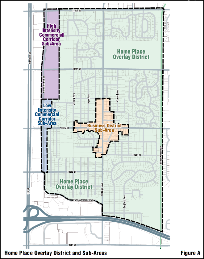
It is the purpose of the Home Place Overlay District to promote and protect the public health, safety, comfort, convenience and general welfare by providing for consistent and coordinated treatment of the properties located in the Home Place neighborhood in Clay Township, Hamilton County, Indiana. The Plan Commission and Common Council, in establishing this zone, are relying on IC 36-7-4-600 et seq. and IC 36-7-4-1400 et seq. Home Place Business Sub-Area This sub-area is intended to foster urban neighborhood village-like commercial activity, in keeping with the intention of the Comprehensive Plan. It is to contain office and retail uses that are of an intensity and scale compatible with the surrounding residential areas, both in scale and architecture. These commercial uses should provide services and support the existing residential areas and nearby US 31 commercial corridor. West Home Place Commercial Corridor Sub-Area The purpose of West Home Place Commercial Corridor Sub-Area standards is to provide site design, architectural, and landscaping requirements that will create a transition between the commercial uses along US 31 buildings and nearby residential areas. The buildings in this corridor will also serve as a buffer between the intensive commercial uses along US 31 and the existing residential areas. | Permitted Uses
Special Uses
Prohibited Uses
| Application Procedure
Property Applicability If the subject property is located partially inside and outside of the overlay district (or sub-area), then the entire property shall be considered inside the overlay district (or sub-area); thus subject to the applicable regulations and processes. Development Standards Applicability Any development standard in Article 2: Zoning Districts or Article 5: Development Standards applicable to the subject property (base zoning district) shall apply unless the Home Place Overlay District specifies a different standard. Project Applicability These regulations apply to development, expansion, additions, or construction in the Home Place Overlay District, except single-family and two-family residential uses. |
3.02 HP-OL District Boundaries
The boundaries of the Home Place Overlay District and its Sub-Areas are hereby established as shown on the Official Zoning Map. The Home Place Overlay District is generally depicted in Figure A: Home Place Overlay District and Sub‑Areas. The Home Place Overlay District is generally bounded by the following streets: to the west by Pennsylvania Street, to the north by East 116th Street, to the east by the Monon Greenway, and to the south by I-465. The Home Place Overlay District is comprised of the following sub-areas.
- Home Place Business Sub-Area: The Home Place Business Sub-Area is primarily comprised of the properties located near the intersection of East 106th Street and North College Avenue.
- West Home Place Commercial Corridor Sub-Area: The West Home Place Commercial Corridor Sub-Area is comprised of properties on the East side of Pennsylvania Street from East 103rd Street to East 116th Street.
3.03 HP-OL Exemptions
- Property zoned or used as single-family residential or two-family residential shall be exempt from the Home Place Overlay District.
3.04 HP-OL Interpretation
- There are no special interpretations related to this overlay district.
3.05 HP-OL Accessory Building and Use Standards
- General Accessory Building and Use Standards: All Accessory Buildings and Uses which are permitted in the base zoning district(s) shall be permitted.
- Architectural Compatibility Standards: Any detached Accessory Building shall be architecturally compatible with the Principal Building(s) with which it is associated.
- Additions to Existing Residential Standards: Uses and Detached Buildings accessory to Single-family Dwelling Units are permitted provided that the use and/or structure meets the requirements of the base zoning district. Additionally, any detached structure shall be of compatible architectural design with the Principal Building.
3.06 HP-OL Architectural Standards
- Home Place Business Sub-Area Architectural Standards:
- Building Orientation Standards:
- All Principal Buildings shall face the public street.
- The primary building entrance shall be from a public street.
- Secondary building entrances shall face the side or rear of the building.
- Architectural Design Standards:
- Principal Buildings shall be a maximum of two (2) stories.
- The Principal Building shall be primarily composed of brick and/or stucco with other materials used for accent.
- The first and second floors will have a coordinated composition, which will usually be indicated by the alignment of upper floor windows and other features with openings and features on the first floor.
- The two (2) front facades (those facing the public street) of Principal Buildings on Corner Lots shall be of the same materials and similarly detailed.
- In general, buildings will have flat fronts with large window or door openings.
- All window design shall be compatible with the style, materials, color, details and proportion of the building. The number of panes, the way it opens, the trim around it and whether it is embellished with shutters shall be consistent with the architectural style of the structure.
- Rooftop equipment shall be screened from view.
- Building Orientation Standards:
- West Home Place Commercial Corridor Sub-Area Architectural Standards:
- Building Orientation Standards:
- All buildings shall face Pennsylvania Street.
- Low Intensity Commercial Corridor Sub‑Area Architectural Design Standards:
- Buildings shall be residential in character.
- Buildings shall be designed to contribute to the neighborhood scale environment and to be compatible with residential uses in nearby single-family areas.
- Buildings shall be faced in brick and trimmed in metal, stone, pre-cast concrete, wood, or stucco.
- Every face of the building shall have windows.
- Concrete block is not allowed on the exterior.
- Building entrances shall be clearly articulated.
- The architectural style, including materials and detailing, shall be consistent on all sides of the building.
- Rooftop equipment shall be screened from view.
- High Intensity Commercial Corridor Sub‑Area Architectural Design Standards:
- Large expanses of glass are allowed, but the building shall not be constructed entirely of a metal and glass curtain wall.
- A minimum of three (3) materials shall be used for building exteriors, from the following list: stone, brick, architectural pre-cast (panels or detailing), architectural metal panels, glass, and ornamental metal.
- Concrete block shall not be allowed as an exterior finish material.
- Building entrances shall be clearly articulated.
- The architectural style, including materials and detailing, shall be consistent on all sides of the building.
- All buildings shall be designed with respect to the general character of the US 31 Corridor and, particu- larly, with due consideration to buildings located on lots that abut the subject property.
- Rooftop equipment shall be screened from view.
- Building Orientation Standards:
3.07 HP-OL Bike and Pedestrian Facility Standards
- Pedestrian and Bicycle Circulation:
- Neither sidewalks nor walkways shall be used by auto traffic.
- Bicycle parking shall be provided at one (1) space per 100 feet of building frontage.
- Walkways, shall be provided, as applicable, between buildings to provide access between rear parking areas and principal building entrance or the street.
3.08 HP-OL Fence and Wall Standards
- See the applicable base zoning district’s regulations. No overlay-specific standards apply.
3.09 HP-OL Height Standards
- Home Place Business Sub-Area Building Height Standards:
- Minimum: Twenty (20) feet.
- Maximum: Thirty-five (35) feet.
- West Home Place Commercial Corridor Sub-Area Building Height Standards:
- Low Intensity Commercial Corridor Sub‑Area: Buildings located in the Low Commercial Corridor Sub-Area shall be a maximum of two (2) stories tall or thirty (30) feet, whichever is less.
- High Intensity Commercial Corridor Sub‑Area: Buildings located in the High Intensity Commercial Corridor Sub-Area shall be a maximum of three (3) stories tall or forty-five (45) feet, whichever is less.
3.10 HP-OL Landscaping Standards
- Protection of Existing Trees and Vegetation Standards:
- Sites within the Home Place Overlay District with existing trees or stands of trees shall protect and incorporate them into the overall site design. The Landscape Plan shall preserve not less than fifty percent (50%) of all trees that are:
- Six-inch (6”) DBH or larger, and
- Located within the Bufferyard or Greenbelt.
- Protection of Existing Trees: Sites with existing trees or stands of trees should make reasonable efforts to protect and incorporate them into the overall site design. Existing vegetation proposed to be removed and tree preservation areas shall be graphically illustrated on a separate plan, to be called the Tree Preservation Plan. (See City of Carmel’s Tree Preservation Detail)
- Tree Preservation Plans should be prepared by an International Society of Arboriculture Certified Arborist or Board Certified Master Arborist, American Society of Consulting Arborists Registered Consulting Arborist, state licensed Landscape Architect or similar professional.
- When tree preservation is not possible due to other site constraints, the Director of Community Services may require a reforestation or afforestation plan.
- Sites within the Home Place Overlay District with existing trees or stands of trees shall protect and incorporate them into the overall site design. The Landscape Plan shall preserve not less than fifty percent (50%) of all trees that are:
- Home Place Business Sub-Area Buffer Standards:
- Any properties adjacent to or abutting an existing residence or residential area shall create at least a five-foot (5’) wide buffer consisting of a minimum of three (3) shade trees, two (2) ornamental trees, and nine (9) shrubs per 100 linear foot increment.
- West Home Place Commercial Corridor Sub-Area Buffer Standards:
- Low Intensity Commercial Corridor Sub-Area: Any properties adjacent to or abutting an existing residence or residential area shall create at least a five-foot (5’) wide buffer consisting of a minimum of three (3) shade trees, two (2) ornamental trees, and nine (9) shrubs per 100 linear foot increment.
- High Intensity Commercial Corridor Sub-Area: Any properties adjacent to or abutting an existing residence or residential area shall create at least a ten-foot (10’) wide buffer consisting of a minimum of five (5) shade trees, four (4) ornamental trees, and fifteen (15) shrubs per 100 linear foot increment.
3.11 HP-OL Lighting Standards
- General Lighting Standards:
- Storefronts shall be internally illuminated to prominently and attractively display the business and/or its products.
- Exterior lighting may be affixed to the building.
- Pedestrian passages to parking lots (walkways) shall be lit to a minimum of three (3) foot-candles.
- All exterior architectural, display, decorative, and sign lighting shall be generated from concealed, low level fixtures.
- Exterior lighting shall be architecturally integrated with the building style, material and color. Rooftop lighting shall be prohibited.
- Lighting Height Standards: The maximum height of lighting standards in parking areas shall not exceed the Building Height or twenty-five (25) feet, whichever is less. When light standards abut or fall within ninety (90) feet of single-family residential areas, their height shall not exceed fifteen (15) feet.
3.12 HP-OL Lot Standards
- See the applicable base zoning district’s regulations. No overlay-specific standards apply.
3.13 HP-OL Outdoor Display Standards
- Product Material and Refuse Storage Standards:
- Material or product storage shall occur within the Principal Building or an Accessory Building.
- Any Accessory Building used for storage shall:
- Be architecturally compatible with the Principal Building and integrated into the overall site layout, and
- Be approved by the Plan Commission.
- Any Accessory Building use for storage or disposal of refuse shall:
- Accommodate waste and recyclable materials, and, if applicable, grease or other cooking refuse,
- Be architecturally compatible with the Principal Building and integrated into the overall site layout, and
- Be approved by the Plan Commission.
3.14 HP-OL Parking Standards
- General Parking Standards:
- No parking shall be allowed in the Front Yard.
- All parking shall be paved with asphalt or concrete, and curbed using poured-in-place concrete curbing.
- Parking areas shall be located at the rear or side of buildings, and screened from the sidewalk by low walls, low fences or hedges.
- Parking space dimensions shall be nine feet by twenty feet (9’ x 20’) or ten feet by eighteen feet (10’ x 18’).
- Connectivity Standards: Adjacent/adjoining lots shall be interconnected either by alleys or internal driveways.
- Home Place Business Sub-Area Parking Standards:
- Parking shall be provided at the minimum ratio of one (1) space per 1,000 square feet of Gross Floor Area.
3.15 HP-OL Setback Standards
- Home Place Business Sub-Area Setback Standards:
- Front YardSetback:
- Minimum: Five (5) feet from Front Lot Line.
- Maximum: Fifteen (15) feet from Front Lot Line.
- Uses which require outdoor seating shall be set back no less than ten (10) feet.
- Minimum Side YardSetback:
- Minimum Rear YardSetback:
- Minimum: Ten (10) feet
- See also Section 3.10: HP‑OL Landscaping Standard.
- Front YardSetback:
- West Home Place Commercial Corridor Sub-Area Setback Standards:
- Front YardSetback:
- Minimum: Five (5) feet
- Side YardSetback:
- Minimum: Ten (10) feet
- Rear YardSetback:
- Next to existing residence(s): Fifteen (15) feet
- Next to existing business: Ten (10) feet
- Front YardSetback:
3.16 HP-OL Sign Standards
- See the applicable base zoning district’s regulations. No overlay-specific standards apply.
3.17 HP-OL Site Design Standards
- West Home Place Commercial Corridor Sub-Area Architectural Standards:
- Vehicular Entrances:
- The primary vehicular entrance shall be from at least a boulevard street.
- Secondary vehicular entrances shall not be through residential areas.
- Vehicular Entrances:
3.18 HP-OL Structure Standards
- Home Place Business Sub-Area Gross Floor Area Standards:
- Maximum Gross Floor Area: 15,000 square feet.
- West Home Place Commercial Corridor Sub-Area Gross Floor Area Standards:
- Maximum Gross Floor Area: No limit.
3.19 HP-OL Other Standards
- See the applicable base zoning district’s regulations. No overlay-specific standards apply.
3.20 KP-OL District Intent, Effect on Uses, Process and Applicability
| DistrictIntent | EffectonUses | Process andApplicability |
The purpose of this overlay district is:
This overlay district is superimposed over the other base zoning districts and its regulations shall supersede those of the base zoning districts over which it is superimposed. The Plan Commission, in establishing this overlay district, is relying on IC 36-7-4-100 et seq. | Permitted Uses
Special Uses
Prohibited Uses
| Development Plan Approval Development Plan (DP): Shall be per the base zoning district. ADLS Approval Property Zoned and/or Used for:
Property Applicability If the subject property is located partially inside and outside of the overlay district, then the entire property shall be subject to the overlay district regulations and its applicable processes. Any development standard in Article 2: Zoning Districts or Article 5: Development Standards applicable to the subject property (base zoning district) shall apply unless this overlay district specifies a different standard. |
3.21 KP-OL District Boundaries
The Keystone Parkway Overlay District shall generally include an area of 120 feet on either side of the right-of-way for Keystone Parkway. The official boundaries of the Keystone Parkway Overlay District are hereby established as drawn on the Official Zoning Map.
3.22 KP-OL Exemptions
- There are no special exemptions related to this overlay district.
3.23 KP-OL Interpretation
- There are no special interpretations related to this overlay district.
3.24 KP-OL Accessory Building and Use Standards
- See the applicable base zoning district’s regulations. No overlay-specific standards apply.
3.25 KP-OL Architectural Standards
- See the applicable base zoning district’s regulations. No overlay-specific standards apply.
3.26 KP-OL Fence and Wall Standards
- See the applicable base zoning district’s regulations. No overlay-specific standards apply.
3.27 KP-OL Height Standards
- See the applicable base zoning district’s regulations. No overlay-specific standards apply.
3.28 KP-OL Landscaping Standards
- Greenbelt Standards:
- Greenbelt Width: A landscaped Greenbelt area shall extend along the Right-of-Way of Keystone Parkway with a minimum width of thirty (30) feet.
- Greenbelt Planting: A minimum base-planting unit for each 100 linear foot increment of the Greenbelt has been designated, as follows:
- Six (6) shade trees
- Two (2) ornamental trees
- Fifteen (15) shrubs
3.29 KP-OL Lighting Standards
- See the applicable base zoning district’s regulations. No overlay-specific standards apply.
3.30 KP-OL Lot Standards
- Minimum Front Yard Standards: Measured from the right-of-way of Keystone Parkway:
- Residential Zones: Thirty (30) feet.
- Business, Industrial, and Manufacturing Districts and/or Uses: 120 feet.
3.31 KP-OL Outdoor Display Standards
- See the applicable base zoning district’s regulations. No overlay-specific standards apply.
3.32 KP-OL Parking Standards
- See the applicable base zoning district’s regulations. No overlay-specific standards apply.
3.33 KP-OL Setback Standards
- See the applicable base zoning district’s regulations. No overlay-specific standards apply.
3.34 KP-OL Sign Standards
- See the applicable base zoning district’s regulations. No overlay-specific standards apply.
3.35 KP-OL Site Design Standards
- See the applicable base zoning district’s regulations. No overlay-specific standards apply.
3.36 KP-OL Structure Standards
- See the applicable base zoning district’s regulations. No overlay-specific standards apply.
3.37 KP-OL Other Standards
- See the applicable base zoning district’s regulations. No overlay-specific standards apply.
3.38 MG-OL District Intent, Effect on Uses, Process and Applicability
| DistrictIntent | EffectonUses | Process andApplicability |
| The purpose of the Monon Greenway Overlay District is to protect and enhance the health, safety and welfare of the citizens and property owners of Carmel by pro- tecting the physical integrity of the Monon Greenway, including its ballast foundation and drainage ways, and by complying with the Monon Greenway easement covenants as they pertain to the natural character and existing vegetation of the trail and its pro- tection. For purposes of this overlay dis- trict, the Monon Greenway shall be defined as any property conveyed to the City of Carmel, by title or easement, for purposes of establishment of the Monon Greenway. It is the City’s intent to achieve the purpose of this overlay district by:
This overlay district is superimposed over the other base zoning districts and its regulations shall supersede those of the base zoning districts over which it is superimposed. In establishing this overlay district, the Plan Commission and Common Council relies on IC 36-7-4-1400 et seq. | Permitted Uses
Special Uses
Prohibited Uses
| Application Procedure
Property Applicability If the subject property is located partially inside and outside of the overlay district (or sub-area), then the entire property shall be considered inside the overlay district (or sub-area); thus subject to the applicable regulations and processes.
|
3.39 MG-OL District Boundaries
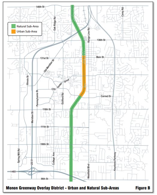
The official boundaries of the Monon Greenway Overlay District and its Sub-Areas are as illustrated on the Official Zoning Map. Generally, the boundaries are illustrated in Figure B: Monon Greenway Overlay District‑ Urban and Natural Sub‑Areas, extending eighty-eight (88) feet from the centerline of the Monon Greenway. The Sub-Areas are further described below.
- Urban Sub-Area Boundary: Properties which abut the Monon Greenway from First Street NW to the southern property line of properties fronting the south side of Carmel Drive.
- Natural Sub-Area Boundary: Properties which abut the Monon Greenway from 146th Street to First Street NW and Carmel Drive to 96th Street.
3.40 MG-OL Exemptions
- Exemption: Parcels in the C1 District and C2 Districts shall be exempt from the requirements of the Monon Greenway Overlay District.
3.41 MG-OL Interpretation
- Conflicts: The Old Town Overlay District and Home Place Overlay District shall govern over the Monon Greenway Overlay District where conflicts exist, except the requirements in Section 3.51: MG‑OL Setback Standards shall apply. The Monon Greenway Overlay District shall also govern in instances where other overlay districts are silent.
3.42 MG-OL Accessory Building and Use Standards
- See the applicable base zoning district’s regulations. No overlay-specific standards apply.
3.43 MG-OL Architectural Standards
- Urban Sub-Area Architectural Design: Buildings in the Urban Sub-Area with frontage on the Monon Greenway shall include the following characteristics:
- Large blank facades are not allowed. Buildings with continuous facades that are fifty feet (50’) or greater in width, shall be designed with offsets (projecting or recessed) not less than eight feet (8’) in depth and continu- ous for not less than twenty-five feet (25’) along the length of the facade.
- All elevations shall exhibit variety through inclusion of architectural elements such as windows and surrounds, storefronts, doors, special brick coursing, pilasters, lintels, canopies and covered walkways or recesses. Facades shall also exhibit variable roof heights, a diversity of building materials and varied building mass within a given structure.
- Architectural elements shall be arranged in a balanced, relatively uniform fashion. Faux window openings and special masonry coursing may be used in service areas, especially areas where rooftop skylighting is designed.
- Ground and upper floors shall utilize transparent glass; the ground floor elevations of non-residential uses must incorporate the transparent glass as a significant component.
- The first floor and all other floors will have a coordinated composition, which will usually be indicated by the alignment of upper floor windows and other features with openings and features of the first floor.
- Retail storefronts shall have a primary entrance oriented along the Monon Greenway on the first floor of the building, other entrances such as pedestrian entrances to parking areas shall be permitted on non-greenway facades.
- Every facade of a building abutting the Monon Greenway shall have openings for windows.
- Large expanses of glass are allowed, but no facade may be constructed entirely of a metal and glass curtain wall.
- Fixed or retractable awnings are encouraged if they complement a building’s architectural style, material, colors, and details; do not conceal architectural features (such as cornices, columns, pilasters, or decorative details); do not impair facade composition; and are designed as an integral part of the facade. Awnings may not be internally illuminated.
- Pedestrian scale detailing is required at the ground level. As the buildings will be viewed very close up, it is important to exhibit articulated detail and ornament that is scaled to the pedestrian. Examples include, but are not limited to cornices, columns, pilasters, lighting, decorative moldings, sills and quoins, as well as canopies, awnings covered walkways and other similar sheltering features.
- Modulation of the roof and/or roof line are required in order to eliminate box-shaped buildings. Parapets shall be fully integrated into the architectural design of the building and provide seamless design transitions, including exterior materials between the main building mass, mechanical penthouses and other roof structures. Should they be used, partial parapets shall have a return that extends inward to at least the first structural bay, or twenty (20) feet, whichever is greater. Parapet heights shall vary by no less than three (3) feet, including between neighboring structures on the same or adjacent parcel.
- Architectural styles, primary materials, building setbacks, separations, heights and mass shall vary among neighboring buildings along the Monon Greenway.
3.44 MG-OL Fence and Wall Standards
- See the applicable base zoning district’s regulations. No overlay-specific standards apply.
3.45 MG-OL Height Standards
- Urban Sub-Area:
- Minimum Height: None.
- Maximum Height: Sixty (60) feet, or as permitted in the base zoning district, whichever is greater.
- When adjacent to a residential district, the building height shall be limited to the maximum height of that residential district.
- When used, facade step backs shall be at least twenty feet (20’) in depth and shall be constructed as usable outdoor space, such as a rooftop patio or garden.
- Natural Sub-Area:
- Minimum Height: None.
- Maximum Height: As permitted in the base zoning district.
3.46 MG-OL Landscaping Standards
- This Overlay District is exempt from any landscaping requirements within Section 5.19: Commercial Landscaping Standards, and requires only landscaping which is stated herein.
- Urban Sub-Area Landscaping Standards:
- Planting Requirements:
- When a Development Plan or other Plan Commission approval includes or requires reconstruction of the Monon Greenway, the Landscape Plan shall comply with the Monon Greenway Cross Section require- ments and shall meet the approval of the Director of Carmel-Clay Parks and the Director of Community Services.
- The Monon Greenway Setback shall be landscaped with a combination of shade trees, shrubs, planting beds and ground cover, with exceptions for appropriate pedestrian access to building entrances.
- Alternatively, the Monon Greenway Setback may be covered with decorative hard surfaces and/or pavers to allow seating areas or outdoor tables; such areas shall be surrounded by low shrubs or planting beds.
- Remaining facades shall have foundation plantings in beds no less than five (5) feet in width, with exceptions for appropriate pedestrian access to building entrances. Initially, plantings shall cover at least seventy-five percent (75%) of the base of the building (horizontally).
- Tree Preservation Requirements: Existing vegetation within the Monon Greenway Easement or Right-of-Way shall be preserved in accordance with the Monon Greenway covenants. Proposed preservation plans or alter- ations to the existing vegetation in the Monon Greenway may be sought through a Development Plan/ADLS proposal and require the approval of the Director of Carmel-Clay Parks. Otherwise no changes to the Monon Greenway vegetation shall be made. Any proposed preservation or alteration outside of the Monon Greenway shall be reviewed by the Director of Community Services and Plan Commission and shall be in accordance with Section 3.46: MG‑OL Landscaping Standards. When deemed appropriate, and upon the approval of the Director of Community Services, mitigation may occur within the Monon Greenway.
- Planting Requirements:
- Natural Sub-Area Landscaping Standards:
- Planting Requirements: When a Bufferyard is required per Section 5.20: BufferyardStandards, plantings along the Monon Greenway shall be provided as said type ‘C’ Bufferyard.
- Tree Preservation Requirements: Existing vegetation within the Monon Greenway Easement or Right-of-Way shall be preserved in accordance with the Monon Greenway covenants. Proposed preservation plans or alterations to the existing vegetation in the Monon Greenway may be sought through a Development Plan/ ADLS proposal and require the approval of the Director of Carmel-Clay Parks. Otherwise no changes to the Monon Greenway vegetation shall be made. Any proposed preservation or alteration outside of the Monon Greenway shall be reviewed by the Director of Community Services and Plan Commission, and shall be in accordance with Section 3.46(D): General Landscaping Standards. When deemed appropriate, and upon the approval of the Director of Community Services, mitigation may occur within the Monon Greenway.
- General Landscaping Standards: The requirements of this section shall apply to projects which require Plan Commission approval, including Development Plan, ADLS and Primary Plat review.
- Sites with existing trees or stands of trees shall protect and incorporate them into the overall site design. The landscape plan shall preserve not less than seventy-five percent (75%) of all trees that are six inch (6”) DBH or larger and located within the required yard/setback areas.
- A five (5) foot wide planting area shall be provided along all sides of parking areas. The minimum planting shall include two (2) shade trees and thirty (30) shrubs per 100 linear feet.
- Parking areas shall be located at the rear or side of buildings, and screened from the Monon Greenway by low walls, low fences, or hedges, or a combination thereof.
- There shall be planted, at minimum, one (1) shade tree and five (5) shrubs per every ten (10) parking spaces.
- The design of fencing, sound walls, trash enclosures and similar site elements shall replicate the architecture of the Principal building(s) in construction material and detailing. No openings or access gates for trash enclosures shall face the Monon Greenway.
- Protection of Existing Trees and Vegetation:
- Sites within the Monon Greenway Overlay District with existing trees or stands of trees shall protect and incorporate them into the overall site design. The Landscape Plan shall preserve not less than fifty percent (50%) of all trees that are:
- Six-inches (6”) DBH or larger, and
- Located within the Bufferyard or Greenbelt.
- Protection of Existing Trees: Sites with existing trees or stands of trees shall make reasonable efforts to protect and incorporate them into the overall site design. Existing vegetation proposed to be removed and tree preser- vation areas shall be graphically illustrated on a separate plan, to be called the Tree Preservation Plan. (See City of Carmel’s Tree Preservation Detail)
- Tree Preservation Plans shall be prepared by an International Society of Arboriculture Certified Arborist or Board Certified Master Arborist, American Society of Consulting Arborists Registered Consulting Arborist, state licensed Landscape Architect or similar professional.
- When tree preservation is not possible due to other site constraints, the Director of Community Services may require a reforestation or afforestation plan.
- Sites within the Monon Greenway Overlay District with existing trees or stands of trees shall protect and incorporate them into the overall site design. The Landscape Plan shall preserve not less than fifty percent (50%) of all trees that are:
3.47 MG-OL Lighting Standards
- Applicability: The requirements of this section shall apply to projects which require Plan Commission approval, including Development Plan, ADLS and Primary Plat review.
- Light Trespass: Exterior lighting of the building(s) or site shall be designed so that light is not directed off the site and the light source is shielded from direct offsite viewing.
- Integration: Exterior lighting shall be architecturally integrated with the building style, material and color. Rooftop lighting shall be prohibited.
- Direction: All exterior architectural, display, decorative and sign lighting shall be generated from concealed, low level fixtures.
- Maximum Light Standard Height: The maximum height of light standards in parking areas shall not exceed the building height, or twenty-five (25) feet, whichever is less. When light standards abut or fall within ninety (90) feet of single family residential properties, their height shall not exceed fifteen (15) feet.
3.48 MG-OL Lot Standards
- See the applicable base zoning district’s regulations. No overlay-specific standards apply.
3.49 MG-OL Outdoor Display Standards
- See the applicable base zoning district’s regulations. No overlay-specific standards apply.
3.50 MG-OL Parking Standards
- Applicability: The requirements of this section shall apply to projects which require Plan Commission approval, including Development Plan, ADLS and Primary Plat review.
- Automobile Parking: Parking shall be provided per Section 5.28(B): Additional Parking and Loading Regulations, unless otherwise stated for parcels in the Old Town Overlay District.
- Bicycle Parking: Bicycle parking shall be provided in accordance with Section 5.29: Bicycle Parking Standards; however, the required number of bicycle parking spaces in the Monon Greenway Overlay District shall be double. The number of spaces may include the long-term bicycle parking required in Section 5.29(C): Long‑term Bicycle Parking. Upon approval by the Alternative Transportation Coordinator, bicycle parking may be located in the Monon Greenway Easement (Urban Sub-Area only).
- Parking Setback: Parking areas shall be set back not less than twenty (20) feet behind the Front Line of Building, and shall include landscaping as required in Section 3.55(B): Building Requirements. Open spaces created by this setback shall become pocket parks, landscaped gathering spaces or space for other greenway-related amenities.
- Parking Structures: Parking structures are permitted adjacent to the Monon Greenway; provided that all levels of the facade facing the Monon Greenway are a non-parking use, or a below-grade parking structure acts as a building foundation completely screened from the view of the Monon Greenway. Uses may be residential or non-residential in nature.
3.51 MG-OL Setback Standards
- Urban Sub-Area.
- Minimum Greenway Setback:
- Minimum: Forty-five (45) feet, measured from the centerline of the Monon Greenway.
- Maximum: There is no maximum setback; however, the area adjacent to the Monon Greenway may not be used solely for parking. In addition, this area shall reflect an awareness of the Monon Greenway and shall not adversely impact the character of the Monon Greenway.
- Front Setbacks not abutting the Monon Greenway: Requirements per base zoning district or other applicable Overlay District.
- Side and Rear Setbacks: Fifteen (15) feet.
- Minimum Greenway Setback:
- Natural Sub-Area:
- Minimum Greenway Setback: Setbacks shall be measured from the centerline of the Monon Greenway.
- Existing structures on Lots recorded prior to January 1, 2012, may continue to follow the requirements of the base zoning district or other Overlay District, when applicable.
- New Detached Single-Family Dwellings: Requirements per base zoning district or other applicable Overlay District.
- Other New Principal Buildings: Eighty-eight (88) feet.
- Accessory Buildings: See Section 5.02: Residential Accessory Building and Use Standards.
- Setbacks not abutting the Monon Greenway: Requirements per base zoning district or applicable Overlay District.
- Minimum Greenway Setback: Setbacks shall be measured from the centerline of the Monon Greenway.
3.52 MG-OL Sign Standards
- All signs shall be in accordance with Section 5.39: Sign Standards and/or other applicable Overlay District Requirements. In addition, the following standards shall apply to signs facing the Monon Greenway:
- Wall Signs are allowed in the Urban Sub-Area provided that they fit within the horizontal and vertical elements of the building and do not obscure details of the building. No sign shall be allowed to extend above the cornice line of a building. Wall Signs shall comply with Section 5.39: Sign Standards for size and shall be in accordance with an approved ADLS.
- Projecting Signs no larger than six (6) square feet are allowed for new or existing buildings in the Urban Sub-Area which comply with applicable setback, orientation and height requirements.
3.53 MG-OL Site Design Standards
- See the applicable base zoning district’s regulations. No overlay-specific standards apply.
3.54 MG-OL Structure Standards
- Building Orientation and Footprint:
- Urban Sub‑Area:
- Natural Sub‑Area:
- Maximum Building Footprint: 15,000 square feet.
- Maximum Facade Length: No facade greater than eighty (80) feet in length shall be parallel with the Monon Greenway. Longer facades shall be oriented at an angle greater than or equal to sixty degrees (60°) from the property line abutting the Monon Greenway.
3.55 MG-OL Other Standards
- Monon Greenway Access Points
- New Principal Buildings: Monon Greenway Access Points, for new residential or any commercial construc- tion, shall be designed and built in accordance with Carmel-Clay Board of Parks and Recreation standards and as approved by the applicable process. All access points shall be constructed of durable materials and shall be designed as to not impede drainage ways. Where determined appropriate, a non-access agreement may be required to be recorded.
- Existing Buildings: Monon Greenway Access Points from existing buildings shall receive the approval of the Board of Public Works and Safety. All access points shall be designed as to not impede drainage ways.
- Building Requirements:
- New principal buildings with a gross floor area containing more than 15,000 non-residential square feet shall contain a shower, changing and locker facility accessible for employee use.
- New principal buildings with a gross floor area containing more than 15,000 square feet shall provide covered, long term bicycle parking at a rate of one (1) space per 5,000 square feet. Long term bicycle parking may include an indoor storage area and/or exterior bicycle lockers, as approved as part of an ADLS plan.
- Boundary Markers: Upon application for Plan Commission approval, a staked survey shall be completed to determine the Monon Greenway property line. Prior to commencing and throughout the duration of construction, boundary markers shall be placed at the edge of the Monon Greenway Right-of Way. Monuments shall be at least twenty-four inches (24”) in height and placed at the property corners abutting the Monon Greenway. In addition, a temporary construction fence shall be placed along the Monon Greenway boundary prior to site work commencing and throughout the duration of construction.
- Monon Greenway Documents: Upon application for Plan Commission approval applicant shall provide a copy of the deed by which the title and any associated easements were conveyed.
3.56 OT-OL District Intent, Effect on Uses, Process and Applicability
| DistrictIntent | EffectonUses | Process andApplicability |
It is the purpose of the Old Town Overlay District to promote and protect the public health, safety, comfort, convenience Further, the Old Town Overlay District Seeks to:
Within the Old Town Overlay District there are different parts and characteristics, therefore, the overlay district is divided into three Sub-Areas: a Character Sub Area, a Historic Range Line Road Sub-Area, and Main Street Sub-Area. Separate guidelines apply to each Sub-Area. | Permitted Uses
Special Uses
Prohibited Uses
Prohibited Uses in the Main Street Sub-Area
| Application Procedure
Property Applicability If the subject property is located partially inside and outside of the overlay district (or sub-area), then the entire property shall be considered inside the overlay district (or sub-area); thus subject to the applicable regulations and processes. Development Standards Applicability |
3.57 OT-OL District Boundaries
The boundaries of the Old Town Overlay District are hereby established as illustrated on Figure C: Old Town Overlay District and Sub‑Areas.
3.58 OT-OL Exemptions
- There are no special exemptions related to this overlay district.
3.59 OT-OL Interpretation
- There are no special interpretations related to this overlay district.
3.60 OT-OL Accessory Building and Use Standards
- See the applicable base zoning district’s regulations. No overlay-specific standards apply.
3.61 OT-OL Architectural Standards
- Buildings Covered by Regulations:
- Applicability of Design Regulations: Any alteration, addition or new construction within the Old Town Overlay District that requires a building permit shall be reviewed for conformance with these regulations. Wherever there exists a C2 Mixed Use District within the Old Town Overlay District, the development stan- dards and procedures of the C2 Mixed Use District shall govern.
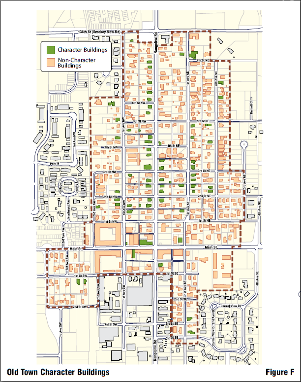
- Character Buildings and Non-character Buildings:
- Reconstruction: Redevelopment or reconstruction of a property where the existing building has been demol- ished will be considered new construction, regardless of the classification of buildings previously existing on that site, except as provided in Section 3.61(B)(2): Demolition.
- Demolition: No Character Building, or any part of it, may be demolished in the Old Town Overlay District without the consent of the Director of Community Services. Before receiving any permits or undertaking any work that constitutes demolition, the applicant shall comply with Article 9: Processes.
- The Director of Community Services shall only consider the following when determining whether a building or any part of it may be demolished:
- Structural conditions pose an imminent safety hazard.
- An advanced state of dilapidation or fire damage would make it unfeasible to repair the building for any reasonable economic use.
- Significance: The Director of Community Services shall consider the architectural and historical signifi- cance of the structure individually, in relation to the street, and as a part of the district as a whole. These same considerations will be given to parts of the building. The Director of Community Services will also consider how the loss of a building, or a portion thereof, will affect the character of the Old Town Overlay District, the neighboring buildings, and, in the case of partial demolition, the building itself. Buildings that are noted as non-character buildings shall be researched to confirm that there is no obscured architectural or historical significance.
In making its determination of significance, the Director of Community Services shall consider the following:
- Architectural and historic information and significance.
- Information contained in the district’s National Register nomination (if one exists).
- The Hamilton County Interim Report, as amended, published March 1992 by the Historic Landmarks Foundation of Indiana.
- Information contained in any other professionally conducted historic surveys pertaining to the Old Town Overlay District.
- The opinion of Planning Administrator.
- Evidence presented by the applicant.
- Evidence presented by recognized experts in architectural history.
d. Replacement: Demolition of a structure may be justified when, in the opinion of the Director of Community Services, the proposed new development with which it will be replaced is of greater significance to the enhancement of the Old Town Overlay District than retention of the existing structure. This will only be the case when the structure to be demolished is not of material significance, the loss of the structure will have minimal effect on the historic character of the district, and the new development will be compatible, appropriate and beneficial to the Old Town Overlay District.
To afford the Director of Community Services the ability to consider demolition on the basis of replace- ment development, the applicant shall submit the following:
- Information required by Article 9: Processes;
- A scaled streetscape drawing showing the new development in its context, including at least two (2) buildings on either side; and
- Other pertinent documents deemed relevant by the Director of Community Services.
4. For the purpose of the Old Town Overlay District, demolition shall be defined as the razing, wrecking, or removal by any means of the entire or partial exterior of a structure. The following examples are meant to help define demolition and are not all-inclusive:
- The razing, wrecking, or removal of a total structure.
- The razing, wrecking, or removal of a part a structure, resulting in a reduction in its mass, height or volume.
- The razing, wrecking, or removal of an enclosed or open addition.
5. Some work that may otherwise be considered demolition may be considered rehabilitation, if done in conjunc- tion with Site Plan and Design Review. Examples of rehabilitation include:
- The removal or destruction of exterior siding and face material, exterior surface trim and portions or exterior walls.
- The removal or destruction of those elements which provide enclosure at openings in any exterior wall (e.g., window units, doors, panels).
- The removal or destruction of architectural, decorative or structural features and elements which are attached to the exterior of a structure (e.g., parapets, cornices, brackets, chimneys).
6. Examples of work not included in demolition:
- Any work on the interior of a structure.
- The removal of exterior utility and mechanical equipment.
- The removal, when not structurally integrated with the main structure, of awnings, gutters, downspouts, light fixtures, open fire escapes, and other attachments.
- The removal of signs.
- The removal of paint.
- The removal of site improvement features such as fencing, sidewalks, streets, driveways, curbs, alleys, landscaping and asphalt.
- The replacement of clear glass with no historic markings.
NOTE: Section 3.61(B)(6)(b) through Section 3.61(B)(6)(f) may be considered rehabilitation and require a Site Plan and Design Review, per Article 9: Processes.
7. However, where a building has been demolished due to fire or other accident or disaster that is customarily covered by insurance, the owner may reconstruct the property in accordance with the regulations in the applica- ble sub-area in Section 3.62: Historic Range Line Road Sub‑Area, Section 3.63: Main Street Sub‑Area, Section 3.68: Character Sub‑Area, or reconstruct the structure substantially like the structure that existed prior to the accident, after he/she receives Site Plan and Design Review.
C. Features of Character Buildings: Buildings shall be considered Character Buildings, regardless of age, if they were originally built with all of the following characteristics, or if they have been altered to conform with these characteristics:
- The following are typical of Character Buildings in the Character Sub-Area and the Historic Range Line Road Sub-Area:
- Small lots and small size houses, compared to Carmel’s later subdivisions.
- Narrow house fronts compared to length.
- Hip or gabled roofs.
- Wood clapboard materials and wood or brick details.
- Narrow, rectangular wood windows.
- Detached garages in the rear of the property.
- Consistent Setbacks from the street and narrow Side Yards.
- Front porches (optional).
2. The following are typical elements of buildings in the Main Street Sub-Area:
- Retail uses on the ground floor.
- Transparent storefront glass for most of the length of the frontage.
- Little or no Setback from the sidewalk or right-of-way line.
- Orientation and front door opens toward Main Street.
- Parking in the rear or sides of building, not in the front.
- Pedestrian scale details and variety in the signs, awnings, and storefronts.
- Buildings at least two (2) stories tall.
- Walls faced in brick or wood, not concrete block or metal.
3.62 OT-OL Historic Range Line Road Sub-Area
The Historic Range Line Road Sub-Area encompasses the houses and businesses north of Main Street along Range Line Road. These buildings are generally larger than the others in the Old Town area and are more architecturally distinctive. In addition, their high visibility contributes greatly to the sense of Old Town as a historic area.
- Alterations and Additions to Existing Buildings in the Historic Range Line Road Sub-Area: The following regula- tions shall be applicable to exterior alterations and additions to existing buildings in the Historic Range Line Road Sub-Area, regardless of whether the building is designated a Character or Non-character Building.
- Lot Dimensions and Coverage:
- Existing lot dimensions as originally platted shall be acceptable.
- Minimum Lot Width.
- Single-Family Residence: Fifty (50) feet.
- All Other Uses: Sixty (60) feet.
- Maximum Lot Coverage.
- Single-family Uses: Forty-five percent (45%) of the area of the lot
- All other Uses: Seventy percent (70%) of the area of the lot.
- No lot shall be created by Subdivision or by joining which results in a width greater than ninety (90) feet.
- Setbacks:
- Additions, except for open-air porches, shall not be added to the front of the building except where the building is set back more than twenty (20) feet from the setback line of its nearest two (2) neighbors (See Figure E).
- A Corner Lot for a residential use is presumed to have a front yardsetback on both streets that it faces. For a non-residential use, the front yard shall be Range Line Road (if the property is located on Range Line Road) or the street with the greatest traffic.
- Side and Rear Yard Setbacks shall be a minimum of five (5) feet from the property line.
- Materials: Additions and alterations to the exterior shall use materials consistent with those found on the building when it was originally built.
- Roof: Alterations that reduce the roof pitch of an existing building by more than five degrees (5°) shall not be allowed. Additions shall have a shed, gable, or hip roof. Porch additions may have a flat roof.
- Garages:
- All new garages shall be either:
- Detached Accessory Buildings that are sited at least five (5) feet behind the Front Line of the Principal Building, or
- Attached to the Principal Building so that the front face of the garage is at least fifteen (15) feet further from the Front Lot Line than the Front Line of the Principal Building. New attached garages on Corner Lots shall be oriented to the side street, rather than to Range Line Road.
- Detached or attached three-car garages shall only be permitted where the overhead doors are oriented away from a Front Yard or facing an alley. They may also be located behind the Principal Building on non-Corner Lots.
- New detached or attached garages and other Accessory Buildings shall be exterior materials similar to the Principal Building.
- Covered walkways attaching the garage to the Principal Building shall be permitted.
- All new garages shall be either:
- Lighting and Fencing: See also Article 5, Section 5.03: AB‑02 Non‑Residential Accessory Building and Use Standards.
- Exterior lighting shall be restricted to lamps mounted on the building, seven-foot (7’) maximum-height pole-mounted decorative lights, and low-wattage landscape lighting.
- Fences greater than forty-two inches (42”) tall shall not be allowed in the Front Yard of the property.
- Chain link material shall be prohibited forward of the Front Line of the Principal Building.
- Commercial dumpsters and trash receptacles shall be screened from view at all times.
- Pedestrian Connectivity:
- A paved walkway from the porch or front door to the front sidewalk is required.
- Signs: Signage, where allowed, shall abide by Article 5, Section 5.39: Sign Standards.
- Parking and Driveways:
- Parking shall not be allowed in the Front Yard of any property, except on a paved driveway leading to the garage, and shall not be allowed on any unpaved portion of the property.
- Driveways leading to the garage may not be wider than twelve (12) feet, except within thirty (30) feet of the front of the garage, where the driveway may be:
- Parking spaces required to be provided per the base zoning district may be reduced by up to fifty percent (50%) by the Plan Commission in order to accommodate difficult site conditions such as limited access, small lots, and/or existing mature trees.
- New curb cuts on Range Line Road shall not be permitted unless there is no alternative access from a side street.
- Lot Dimensions and Coverage:
- Alterations and Additions of Character Buildings in the Historic Range Line Road Sub-Area: Alterations and addi- tions to existing Character Buildings in the Historic Range Line Road Sub-Area shall be guided by the following:
- Building Use: Notwithstanding uses otherwise allowed by the base zoning district, uses that require Substantial Alteration or additions to the exterior of a Character Building in order to accommodate the functional require- ments shall not be allowed.
- Materials:
- Details such as porch railings, trim boards, fascia boards, and cornices shall not be removed from the building.
- Original materials of the building will be repaired rather than replaced, when possible.
- When original materials, windows, doors, siding, railings, and other details cannot be repaired, they may only be replaced with architecturally correct materials that simulate the look, details and dimensions of the original. Substitute materials (e.g. vinyl, aluminum, concrete plank) shall meet these standards in order to be acceptable.
- Alterations:
- Alterations to the interior of a historic building shall be allowed if the exterior of the building is not changed.
- No alterations shall be allowed that permanently change the massing, character, window placement or details of the exterior of the original building.
- Previous additions or alterations to the building that detract from or conceal the character of the building may be removed and the building restored to a previous condition. In this process, no attempt shall be made to add “historic” features (e.g., bay windows or gingerbread trim) not actually a part of the original building.
- Additions:
- Additions shall only be allowed in the rear of the building.
- Additions shall not be taller or wider than the existing building.
- Additions shall be designed to complement, but not mimic, the historic architecture
- Additions shall be built in such a way that they can be removed in the future without damage to the original building.
- New Buildings and Their Alterations and Additions in the Historic Range Line Road Sub-Area: The following regulations apply to all new buildings built within the boundaries of the Historic Range Line Road Sub-Area
- Building Mass:
- Buildings shall be oriented parallel and perpendicular to the street.
- Buildings shall generally be longer than they are wide, with the narrow dimension facing the street. Building widths shall not exceed forty-five (45) feet, except where the lot is greater than eighty (80) feet in width, in which case the building may be up to fifty-five (55) feet wide.
- Setbacks:
- New buildings shall follow the dominant or average Front YardSetback dimension of existing buildings on the same block and on the same side of the street, with a variation of up to three (3) feet allowed (See Figure D).
- Side and Rear Yard Setbacks shall be a minimum of five (5) feet from the property line.
- Lot Dimensions and Coverage:
- Minimum Lot Width:
- Single-family Dwelling: Fifty (50) feet.
- All other Uses: Sixty (60) feet.
- Maximum Lot Coverage:
- Single-family Uses: Forty-five percent (45%) of the area of the lot
- All other Uses: Seventy percent (70%) of the area of the lot.
- No lot may be created by Subdivision or by joining which results in a width of greater than ninety (90) feet.
- Minimum Lot Width:
- Materials:
- All sides of the Principal Building and Accessory Buildings shall be clad in wood, brick, stone, or high-quality lap, shake or shingle style cement board. The same material shall be used on all sides of the building.
- New detached garages and other Accessory Buildings should use exterior materials similar to the Principal Building.
- Windows and trim shall be framed in wood or vinyl-clad wood.
- Visible aluminum storm windows or doors shall not be allowed.
- Chimneys shall be brick.
- Exterior guardrails, handrails and other stair details shall be wood or wrought iron.
- Roofs shall be asphalt, wood or slate shingles.
- Foundations shall be split-face block, stone veneer or poured-in-place concrete.
- Windows and Doors:
- Vertical, rectangular double-hung or casement windows shall be required. These may be used in multiple sets to create larger expanses of window area.
- Plate-glass picture windows, strip windows and arched windows shall not be allowed on the front facade.
- Special windows shall not be allowed (ovals, hexagon, etc.) as accents.
- Roof:
- Porches:
- Covered porches facing the street on the first or upper floor of the structure are strongly encouraged but not required.
- Uncovered decks shall not be allowed in the front yard.
- Building Height:
- Minimum: Thirteen (13) feet to the midpoint between the fascia and the ridge.
- Maximum: Thirty (30) feet to the midpoint between the fascia and the ridge, except as provided in Section 3.62(C)(8)(c).
- Buildings shall not exceed the height of the tallest dimension of the nearest two (2) character buildings by more than seven (7) feet. If there are no character buildings in the same block, or across the street, then Section 3.62(C)(8)(b) shall apply.
- Garages:
- All new garages shall be either:
- Detached buildings that are sited at least five (5) feet behind the Front Line of the Principal Building, or
- Attached to the Principal Building so that the front face of the garage is at least fifteen (15) feet further from the Front Lot Line than the Front Line of the Principal Building. New attached garages on Corner Lots shall be oriented to the side street, rather than to Range Line Road.
- Detached or attached three-car garages shall only be permitted where the overhead doors are oriented away from a Front Yard or facing an alley. They may also be located behind the Principal Building on non-Corner Lots.
- New detached or attached garages and other Accessory Buildings shall use exterior materials similar to the Principal Building.
- Covered walkways attaching the garage to the Principal Building shall be permitted.
- All new garages shall be either:
- Lighting and Fencing: See also Section 5.03: Non‑Residential Accessory Building and Use Standards.
- Exterior lighting is restricted to lamps mounted on the building, seven-foot (7’) maximum-height pole- mounted decorative lights, and low-wattage landscape lighting.
- Fences greater than forty-two (42) inches tall shall not be allowed in the Front Yard of the property.
- Chain link material shall be prohibited forward of the Front Line of the Principal Building.
- Commercial dumpsters and trash receptacles shall be screened from view at all times.
- Pedestrian Connectivity:
- A paved walkway from the porch or front door to the front sidewalk shall be required.
- Signs: Signage, where allowed, shall abide by Section 5.39: Sign Standards.
- Parking and Driveways:
- Parking shall not be allowed in the Front Yard of any property, except on a paved driveway leading to the garage, and shall not be allowed on any unpaved portion of the property.
- Driveways leading to the garage shall not be wider than twelve (12) feet, except within thirty (30) feet of the front of the garage, where the driveway may be:
- Parking spaces required to be provided per the base zoning district may be reduced by up to fifty percent (50%) by the Plan Commission in order to accommodate difficult site conditions such as limited access, small lots, and/or existing mature trees.
- New curb cuts on Range Line Road shall not be permitted unless there is no alternative access from a side street.
- Building Mass:
3.63 OT-OL Main Street Sub-Area
Main Street west of Range Line Road is a relatively intact example of street front retail. The emphasis is on encourag- ing new construction and renovations that conform to the desired character and prohibiting changes that do not conform to the existing character.
This Sub-Area will be a focal point of pedestrian commercial activity in the Old Town Overlay District. All new construction, and alterations and additions to new buildings, will follow these regulations:
- Land Use: The base zoning in this district will prevail regarding permitted land uses, with the following exceptions:
- Only those uses allowed in a B1 District shall be allowed on the ground floor in areas that are designated as an I1 District;
- Drive-thru or drive-up facilities shall not be allowed for any use, including automotive, banking or food sales.
- Multiple-family residential uses shall be specifically allowed and encouraged on the upper floors of all buildings.
- Building Mass:
- New buildings and renovations shall follow the general massing of a “Main Street” commercial block (i.e., a rectangular building with a flat or slightly sloped roof, oriented perpendicular to the street).
- Building height shall be limited to three (3) stories.
- The first floor and all other floors shall have a coordinated composition, which will usually be indicated by the alignment of upper floor windows and other features with openings and features of the first floor.
- Materials:
- The first floor and upper floors may be composed of different materials. The facade of the upper floors on any building that faces a public street shall be constructed of wood siding, brick, stucco, or other masonry units, and trimmed in stone, contrasting brick, wood, or pre-cast concrete.
- The first floor of a new or renovated building shall be composed of storefronts, which may be inserted into a masonry, wood, stone or concrete panel frame which is coordinated with the upper floor. Storefronts shall be a lightweight material such as aluminum, glass, wood, tile, and panelized composites.
- The materials in the rear of the building shall be coordinated with the front facade, although they may be different.
- On the front facade, at least sixty percent (60%) of the total area of the first floor (up to the line of the second floor) shall be transparent vision glass.
- Front and side facades of buildings located on corner lots shall be of the same materials and similarly detailed.
- Exterior walks, steps, ramps and paving shall be masonry or stone pavers, or poured or pre-cast concrete, except that concrete pavers shall not be allowed.
- Windows and Doors:
- Each floor shall have windows.
- Roof: Roofs shall have a pitch of less than three to twelve (3:12) and shall not be a substantially visible part of the building.
- Alterations and Additions: Existing buildings may be substantially modified to conform to these regulations, except for designated historic structures.
- Details:
- Cornices and other details of existing buildings shall not be removed.
- The facade shall have a flat front, with relief provided by minor bays, windows and window trim, storefronts, recessed doors, and features such as special brick coursing, pilasters and lintels.
- All new buildings shall have an articulated cornice at the top of the facade wall.
- Setbacks:
- Entrances:
- A separate entrance facing a public street shall be provided to the upper floors of a building if the use differs from the one on the ground floor.
- The principal entrance to all retail areas shall face the public street.
- Additional entrances may face the side of the building.
- No rear entrances are allowed except for residential or office uses, emergency exits, employees, loading and trash removal.
- Storefronts: Storefronts shall be internally illuminated with spots or other incandescent lighting, so as to display prominently and attractively the business or its products; however, digital moving graphics shall not be part of the display. Exterior lighting may be affixed to the building.
- Permanent Signs, Awnings and Murals:
- Signs may be painted on the sides of buildings (See Section 3.63(K)(4)). All such signs shall be included in the calculations for maximum sign area.
- Retractable or fixed fabric awnings are allowed, but these shall fit within the storefront glass area and shall not obscure details of the building. Awnings shall only be supported with building-mounted hardware.
- Individual tenants should strive for a unique graphic image, rather than be required to conform to a single graphic style for the whole building.
- Graphics painted on the sides of buildings that are essentially commercial in character or describe activities in the adjacent building will be considered “signs”. Graphics painted on the sides of buildings are otherwise allowed but shall be reviewed for conformance with this regulation.
- Parking and Loading Requirements:
- Parking lots shall be located in the rear of the building only.
- Parking shall be provided at the ratio of one (1) space for every 1,200 square feet of gross area in the building. Where the total lot area is less than 3,000 square feet, the owner shall be exempt from parking requirements.
- On-street parking shall not be used to fulfill parking requirements; however, a reasonable share of a public lot may be assumed to fulfill these requirements.
- Parking shall provided on-site or in a convenient remote lot not more than 400 feet from the property.
- Parking requirements may be reduced if businesses with substantially different peak hour requirements agree to share parking. A petition shall be filed with the application indicating the terms of agreement of parties to a shared parking arrangement.
- New curb cuts shall not be permitted on Main Street, and no parking lots or loading areas shall front on Main Street.
- Screened loading and trash areas shall be provided for all businesses at the rear of the building. Doors to trash area enclosures shall be kept closed at all times except while employees are emptying trash or dumpsters are being removed.
3.64 OT-OL Character Sub-Area
Character Sub-Areas consist of the bulk of the residential areas in the Old Town Overlay District, both east and west of Range Line Road, and both residential and commercial properties facing Range Line Road in the north end of the District. There are many different styles of architecture in this area; however, the consistency and character of the neighborhood is worth protecting. The intent of these regulations is to preserve the character of the neighborhood by preserving certain buildings and siting characteristics.
- Alterations and Additions to Existing Buildings in the Character Sub-Area: The following regulations shall be applicable to all exterior renovations and additions to existing buildings in the Character Sub-Area, regardless of whether the building is designated a Character Building or Non-character Building.
- Lot Dimensions and Coverages:
- Existing lot dimensions as originally platted shall be acceptable.
- Minimum Lot Width.
- Single-family Residential: Fifty (50) feet.
- All Other Uses: Sixty (60) feet.
- Maximum Lot Coverage.
- Single-family Residential: Forty-five percent (45%) of the area of the Lot.
- All Other Uses: Seventy percent (70%) of the area of the Lot.
- No lot shall be created by Subdivision or by joining resulting in a width greater than ninety (90) feet.
- Setbacks:
- Additions, except for open-air porches, shall not be added to the front of the building except where the building is set back more than twenty (20) feet from the Setback line of its nearest two (2) neighbors (See Figure E, pg 3‑36).
- A Corner Lot for a residential use is presumed to have a Front YardSetback on both streets that it faces. For a non-residential use, the Front Yard shall be Range Line Road (if the property is located on Range Line Road) or the street with the greatest traffic.
- Side and Rear Yard Setbacks shall be a minimum of five (5) feet from the property line.
- Materials:
- Additions and alterations to the exterior shall be clad in wood, brick or lap, shake or shingle style cement board.
- Materials of additions and alterations shall be consistent with the materials in the Principal Building.
- Roof: Alterations that reduce the roof pitch of an existing building more than five degrees (5°) shall not be allowed. Additions shall have a shed, gable, or hip roof. Porch additions may have a flat roof.
- Garages:
- All new garages shall be either:
- Detached buildings that are sited at least five (5) feet behind the Principal Building, or
- Attached to the Principal Building so that the front face of the garage is at least fifteen (15) feet further from the Front Lot Line than the primary front line of the Principal Building. New attached garages on Corner Lots should be oriented to the side street, rather than to Range Line Road.
- Detached or attached three-car garages shall only be permitted where the overhead doors are oriented away from a Front Yard or facing an alley. They may also be located behind the Principal Building on non-Corner Lots
- New detached or attached garages and other Accessory Buildings shall use exterior materials similar to the Principal Building.
- Covered walkways attaching the garage to the Principal Building shall be allowed.
- All new garages shall be either:
- Lighting and Fencing: See also Section 5.03: Non‑Residential Accessory Building and Use Standards.
- Exterior lighting shall be restricted to lamps mounted on the building, seven-foot (7’) maximum-height pole-mounted decorative lights, and low-wattage landscape lighting.
- Fences greater than forty-two (42) inches tall shall not be allowed forward of the Front Line of the Principal Building.
- Vinyl covered chain-link material shall be allowed in the Front Yard except on those properties which front on Range Line Road. For properties fronting on Range Line Road, chain-link material shall be prohibited forward of the Front Line of the Principal Building.
- Dumpsters and trash receptacle shall be screened from view.
- Pedestrian Connectivity:
- A paved walkway from the porch or front door to the front sidewalk is required.
- Signs: Signage, where allowed, shall abide by Section 5.39: Sign Standards.
- Parking and Driveways:
- Parking shall not be allowed in the Front Yard of any property, except on a paved driveway leading to the garage, and shall not be allowed on any unpaved portion of the property.
- Driveways leading to the garage shall not be wider than twelve (12) feet, except within thirty (30) feet of the front of the garage, where the driveway may be:
- Parking spaces required to be provided under the Zoning Ordinance may be reduced by up to fifty percent (50%) by the Plan Commission in order to accommodate difficult site conditions such as limited access, small lots and/or existing mature trees.
- New curb cuts on Range Line Road will not be permitted unless there is no alternative access from a side street.
- Lot Dimensions and Coverages:
- Alterations and Additions to Character Buildings in the Character Sub-Area: Alterations or additions to existing, Character Buildings in the Character Sub-Area shall be guided by the following regulations. Nothing in these regulations shall require a change to a part of the building that is not otherwise affected by the proposed alteration or addition.
- Materials:
- All sides of the Principal and Accessory Buildings shall be clad in wood, brick, or lap, shake or shingle style cement board.
- Windows and trim shall be framed in wood or vinyl-clad wood.
- Clear finish or brush finish aluminum storm windows or doors shall not be allowed.
- Chimneys shall be brick.
- Exterior guardrails, handrails and other stair details shall be wood or wrought iron.
- Roofs shall be asphalt, wood or slate shingles.
- Foundations shall be split-face block, stone veneer or poured-in-place concrete.
- Where previous alterations have introduced inconsistent materials (simulated stone, brick, metal, etc.) to a wood-clapboard house, a new addition or alteration that affects this part of the structure shall require removal of the inconsistent material.
- Windows, Doors:
- Vertical, rectangular double-hung or casement windows shall be required. These may be used in multiple sets to create larger expanses of window area.
- Plate-glass picture windows, strip windows and arched windows shall not be allowed on the front facade.
- Special windows may be used (ovals, hexagon, etc.) as accents.
- Existing windows may be moved or replaced with windows that are similar to the original building windows.
- If a window is covered over or removed, the material on the exterior shall match the pre-existing siding.
- Roof: Roofs shall be gabled, multi-gabled, or hipped, with a minimum pitch of eight to twelve (8:12). Porch roofs may be flat or pitched.
- Porches:
- Removal of existing porches is prohibited, unless the porch is being upgraded or replaced in a manner consistent with these regulations.
- Existing porches shall only be enclosed with transparent glass windows.
- Uncovered decks are not allowed if forward of the Front Line of the Principal Building.
- Building Height: Additions to the existing building shall not exceed the height of the tallest dimension of the nearest Character Buildings by more than seven (7) feet. If there are no Character buildings in the same block, or across the street, then the maximum height shall be thirty (30) feet to the midpoint of the fascia and ridge.
- Materials:
- New Buildings and Their Alterations and Additions in the Character Sub-Area: The following regulations apply to all new buildings built within the boundaries of the Character Sub-Area.
- Building Mass:
- Buildings shall be oriented parallel and perpendicular to the street.
- Buildings shall generally be longer than they are wide, with the narrow dimension facing the street. Building widths shall not exceed forty-five (45) feet, except where the lot is greater than eighty (80) feet in width, in which case the building may be up to fifty-five (55) feet wide.
- Setbacks:
- New buildings shall follow the dominant or average front yardSetback dimension of existing buildings on the same block and on the same side of the street, with a variation of up to three (3) feet allowed (See Figure D, pg 3‑36).
- Additions, except for open-air porches, shall not be added to the front of the building except where the building is set back more than twenty (20) feet from the Setback line of its nearest two neighbors (See Figure E, pg 3‑36).
- A Corner Lot for a residential use is presumed to have a Front YardSetback on both streets that it faces. For a non-residential use, the Front Yard shall be Range Line Road (if the property is located on Range Line Road) or the street with the greatest traffic.
- Side and Rear Yard Setbacks shall be a minimum of five (5) feet from the property line.
- Lot Dimensions and Coverage:
- Existing lot dimensions as originally platted shall be acceptable.
- Minimum lot width:
- Single-family Residential: Fifty (50) feet.
- All Other Uses: Sixty (60) feet.
- Maximum Lot Coverage:
- Single-family Residential: Forty-five percent (45%) of the area of the Lot.
- All Other Uses: Seventy percent (70%) of the area of the Lot.
- No lot may be created by Subdivision or by joining which results in a width greater than ninety (90) feet.
- Garages:
- All new garages shall be either:
- Detached buildings that are sited at least five (5) feet behind the Principal Building, or
- Attached to the Principal Building so that the front face of the garage is at least fifteen (15) feet further from the Front Lot Line than the primary front line of the Principal Building. New attached garages on Corner Lots shall be oriented to the side street, rather than to Range Line Road.
- Detached or attached three-car garages shall only be permitted where the overhead doors are oriented away from a Front Yard or facing an alley. They may also be located behind the Principal Building on non-Corner Lots.
- New detached or attached garages and other Accessory Buildings shall use exterior materials similar to the Principal Building.
- Covered walkways attaching the garage to the Principal Building shall be allowed.
- All new garages shall be either:
- Lighting and Fencing: See also Section 5.19: Commercial Landscaping Standards.
- A paved walkway from the porch or front door to the front sidewalk shall be required.
- Exterior lighting shall be restricted to lamps mounted on the building, seven-foot (7’) maximum-height pole-mounted decorative lights, and low-wattage landscape lighting.
- Fences greater than forty-two (42) inches tall shall not be allowed forward of the Front Line of the Principal Building.
- Vinyl covered chain-link material shall be allowed in the Front Yard except on those properties which front on Range Line Road. For properties fronting on Range Line Road, chain-link material shall be prohibited forward of the Front Line of the Principal Building.
- Commercial dumpsters and trash receptacle shall be screened from view at all times.
- Parking and Driveways:
- Parking shall not be allowed in the Front Yard of any property, except on a paved driveway leading to the garage, and shall not be allowed on any unpaved portion of the property.
- Driveways leading to the garage shall not be wider than twelve (12) feet, except within thirty (30) feet of the front of the garage, where the driveway may be:
- Parking spaces required to be provided under the Zoning Ordinance may be reduced by up to fifty percent (50%) by the Plan Commission in order to accommodate difficult site conditions such as limited access, small lots and/or existing mature trees.
- New curb cuts on Range Line Road shall not be permitted unless there is no alternative access from a side street.
- Materials:
- All sides of the Principal and Accessory Buildings shall be clad in wood, brick, stone or lap, shake, or shingle style cement board. The same material shall be used on all sides of the building.
- New garages and other Accessory Buildings shall use exterior materials similar to the Principal Building.
- Windows and trim shall be framed in wood or vinyl-clad wood.
- Visible aluminum storm windows or doors shall not be allowed.
- Chimneys shall be brick.
- Exterior guardrails, handrails and other stair details shall be wood or wrought iron.
- Roofs shall be asphalt, wood or slate shingles.
- Foundations shall be split-face block, stone veneer or poured-in-place concrete.
- Windows, Doors:
- Vertical, rectangular double-hung or casement windows shall be required. These may be used in multiple sets to create larger expanses of window area.
- Plate-glass picture windows, strip windows and arched windows shall not be allowed on the front facade.
- Special windows may be used (ovals, hexagon, etc.) as accents.
- Roof:
- Porches:
- Covered porches facing the street on the first or upper floor of the structure are strongly encouraged but not required.
- Uncovered decks shall not be allowed in the front yard.
- Building Height:
- Minimum: Thirteen (13) feet to the midpoint of the fascia and the ridge.
- Maximum: Thirty (30) feet to the midpoint of the fascia and the ridge, except as provided in Section 3.64(C)(11)(c).
- Buildings shall not exceed the height of the tallest dimension of the nearest two (2) Character Buildings by more than seven (7) feet. If there are no Character Buildings in the same block, or across the street, then Section 3.64(C)(11)(b) shall apply.
- Building Mass:
3.65 OT-OL Landscaping Standards
- This Overlay District is exempt from any landscaping requirements within Section 5.19: Commercial Landscaping Standards, and requires only landscaping which is stated herein.
- Historic Range Line Road Sub‑Area:
- Lots shall be landscaped and maintained with trees, shrubs, ground cover, flowers and grass for the follow- ing headings:
- Renovations and Additions to All Existing Buildings.
- New Construction.
- Lots shall be landscaped and maintained with trees, shrubs, ground cover, flowers and grass for the follow- ing headings:
- Main Street Sub‑Area: No requirements.
- Character Sub‑Area:
- Lots shall be landscaped and maintained with trees, shrubs, ground cover, flowers and grass for the follow- ing headings:
- Renovations and Additions to All Existing Buildings.
- New Construction.
- Lots shall be landscaped and maintained with trees, shrubs, ground cover, flowers and grass for the follow- ing headings:
- Historic Range Line Road Sub‑Area:
3.66 RL-OL District Intent, Effect on Uses, Process and Applicability
| DistrictIntent | EffectonUses | Process andApplicability |
| The purpose of the Range Line Road Overlay District is to protect and enhance the health, safety and welfare of the citizens and property owners of Carmel by allowing for the establishment of an uptown business district that will support a range of activities and opportunities to all segments of the community; with mixed- uses in multi-story buildings; is pedestrian oriented and supportive of multiple modes of transportation; with buildings and a streetscape which are attractive and safely designed in order to enhance the livability of the City. It is the City’s intent to achieve the purpose of the Range Line Road Overlay District by:
it is superimposed. In establishing the Range Line Road Overlay District, the Plan Commission and Common Council relies on IC 36-7-4-1400 et seq. | Permitted Uses
Special Uses
Prohibited Uses
| Application Procedure
Prohibited Uses If the subject property is located partially inside and outside of the overlay district, then the entire property shall be subject to the overlay district regulations and its applicable processes.
|
3.67 RL-OL District Boundaries
The boundaries of the Range Line Road Overlay District are hereby established as approved on the Official Zoning Map.
3.68 RL-OL Exemptions
- C1 District and C2 District Exemption: Parcels in the C1 District and C2 District shall be exempt from the require- ments of the Range Line Road Overlay District.
- Exemption for Additions: Additions to a principal building that result in fifty percent (50%) or less floor area shall be exempt from Development Plan approval. However, multiple additions to a principal building shall be considered cumulative from January 19, 2005. Upon exceeding fifty percent (50%) additional floor area from multiple additions to a principal building, all additions to a principal building shall require a Development Plan approval.
3.69 RL-OL Conflicting Regulations
Wherever there exists a conflict between the regulations of the Range Line Road Overlay District and the Keystone Parkway Overlay District, the Range Line Road Overlay District shall govern.
3.70 RL-OL Interpretation
- There are no special interpretations related to this overlay district.
3.71 RL-OL Accessory Building and Use Standards
- See the applicable base zoning district’s regulations. No overlay-specific standards apply.
3.72 RL-OL Architectural Standards
- Architectural Design Standards: Buildings shall include the following characteristics:
- Ground and upper floors with transparent glass; ground floor elevations shall incorporate the transparent glass as a significant component.
- A distinct cornice line at the top of flat roofed buildings and intermediate horizontal elements, such as a trim at the top of the ground floor shall be optional.
- The facade shall be provided relief by windows and surrounds, storefronts, doors, and features such as special brick coursing, pilasters and lintels.
- The first floor and all other floors shall have a coordinated composition, which will usually be indicated by the alignment of upper floor windows and other features with openings and features of the first floor.
- When applicable, retail storefronts shall be oriented along the public street front of the first floor of the building, except for pedestrian entrances to parking areas or entrance lobbies for upper floors.
- Every face of the building with frontage on a public street shall have openings for windows which are clear glass that allow the interior space to be Seen from the street.
- Large expanses of glass are allowed, but the building shall not be constructed entirely of a metal and glass curtain wall.
- Fixed or retractable awnings shall be permitted if they complement a building’s architectural style, material, colors, and details; do not conceal architectural features (such as cornices, columns, pilasters, or decorative details); do not impair facade composition; and are designed as an integral part of the facade.
- Rooftop mechanical and telecommunication equipment shall be fully screened on all sides using parapets, penthouse screens or other similar method and which are integrated into the overall building design and approved by the Plan Commission.
- Construction Material Standards:
- Principal Buildings shall be faced on front and sides with brick, stone or similarly detailed precast concrete and trimmed in metal, stone, precast concrete, wood, fiber cement, or EIFS.
- Rear building facade materials may vary, however, its material colors and composition shall be coordinated with the front and side facades.
- Use of EIFS and fiber cement products shall be limited to upper floor trim or upper floor accent material only.
- Building Orientation:
- Every parcel with frontage on Carmel Drive and/or Range Line Road shall have a building that fronts on those streets.
- Every parcel with frontage on Carmel Drive and/or Range Line Road shall have a building that occupies a minimum of seventy percent (70%) of that frontage. Exceptions include:
- Additional buildings may be built in the rear of the property.
- All Principal Buildings shall face a public street, with a primary entrance from a public street.
- The primary entrance shall be readily apparent as a prominent architectural feature and visible from the street.
- Building Footprint:
- Minimum: 0.5 Floor Area Ratio (FAR)
- Maximum: 40,000 square foot footprint.
- Building Entrance: Principal Buildings shall provide a separate, architecturally significant entrance to upper floor uses, when those uses are separate and distinct from that of first floor.
3.73 RL-OL Fence and Wall Standards
- See the applicable base zoning district’s regulations. No overlay-specific standards apply.
3.74 RL-OL Height Standards (See Figure G: Range Line Road Overlay - Building Height Standards)
- Floors: Principal Buildings shall have at least two (2) floors of leasable, occupiable space.
- Minimum Upper Floors: The second and higher floors shall be at least fifty percent (50%) the size of the Principal Building’s footprint and shall be oriented to the front of the Principal Building such that the second floor facade aligns with the first floor.
- Minimum Height: Twenty-six (26) feet.
- Maximum Height: Fifty-five (55) feet, or five (5) stories, whichever is greater.
- Maximum Height shall be reduced to three (3) stories, or thirty-eight (38) feet for a principal building located adjacent to and abutting the R1 District, R2 District or R3 District, or a single-family or two-familydwelling.
3.75 RL-OL Landscaping Standards
- Protection of Existing Trees and Vegetation:
- Sites within the Range Line Road Overlay District with existing trees or stands of trees shall protect and incorporate them into the overall site design. The Landscape Plan shall preserve not less than fifty percent (50%) of all trees that are:
- Six-inches (6”) DBH or larger, and
- Located within the Bufferyard or Greenbelt.
- Protection of Existing Trees: Sites with existing trees or stands of trees shall make reasonable efforts to protect and incorporate them into the overall site design. Existing vegetation proposed to be removed and tree preser- vation areas shall be graphically illustrated on a separate plan, to be called the Tree Preservation Plan. (See City of Carmel’s Tree Preservation Detail)
- Tree Preservation Plans shall be prepared by an International Society of Arboriculture Certified Arborist or Board Certified Master Arborist, American Society of Consulting Arborists Registered Consulting Arborist, state licensed Landscape Architect or similar professional
- When tree preservation is not possible due to other site constraints, the Director of Community Services may require a reforestation or afforestation plan.
- Sites within the Range Line Road Overlay District with existing trees or stands of trees shall protect and incorporate them into the overall site design. The Landscape Plan shall preserve not less than fifty percent (50%) of all trees that are:
3.76 RL-OL Lighting Standards
- Street lighting shall be provided as part of all projects to be placed approximately 100 feet apart. The design shall be per the adopted City style.
- Exterior lighting of the building or site shall be designed so that light is not directed off the site and the light source is shielded from direct offsite viewing. For any use abutting single-family residential uses, illumination levels shall not exceed 0.5 foot-candles at the property line.
- Exterior lighting shall be architecturally integrated with the building style, material and color. Rooftop lighting shall be prohibited.
- All exterior architectural, display, decorative and sign lighting shall be generated from concealed, low level fixtures.
- The maximum height of light standards in parking areas shall not exceed twenty-five (25) feet. When light stan- dards abut or fall within ninety (90) feet of single family residential, their height shall not exceed fifteen (15) feet.
3.77 RL-OL Lot Standards
- See the applicable base zoning district’s regulations. No overlay-specific standards apply.
3.78 RL-OL Outdoor Display Standards
- Product, Material and Refuse Storage:
- Material or product storage shall occur within the Principal building or an Accessory building.
- Any Accessory Building for storage shall:
- Be architecturally compatible with the Principal building and integrated into the overall site layout.
- Be approved by the Plan Commission.
- Any Accessory Building for storage or disposal of refuse shall:
- Accommodate waste and recyclable materials, and, if applicable, grease or other cooking refuse.
- Be fully enclosed except for doors or gates which are kept closed unless loading or unloading.
- Be architecturally compatible with the Principal building and integrated into the overall site layout.
- Be approved by the Plan Commission.
3.79 RL-OL Parking Standards
- Cross Reference: See also Section 5.28: General Parking Standards and Section 5.29: Bicycle Parking Standards.
- The amount of parking spaces required shall be determined by Section 5.30: Amount of Parking Spaces Standards; however, square footage on the second and higher floors will not be included in the automobile parking calculation.
- Parking areas shall be setback not less than six (6) feet behind the Front Line of Building.
- Parking areas shall be located at the rear or side of buildings, and screened consistent with the standards of Bufferyard Type ‘A’, as described in Section 5.21: Bufferyard Standards.
- Adjacent/adjoining parking lots shall be interconnected either by alley or internal driveway, and coordinated to accommodate pedestrian access.
- Paths within parking lots of more than three (3) rows shall be designated to accommodate pedestrians safely from parking areas to sidewalks, walkways and/or building(s). Such paths may consist of striping.
3.80 RL-OL Setback Standards
- Build-to Line:
- Minimum: Zero (0) feet, subject to recorded utility easement(s).
- Maximum: Ten (10) feet, subject to recorded utility easement(s) and to Section3.80(A)(3).
- Up to seventy-percent (70%) of the front facade may be recessed for entrances and outdoor seating; however, no entrance shall be recessed more than ten (10) feet, and no outdoor seating area shall be recessed more than twenty (20) feet, subject to Plan Commission approval.
- Side and Rear Setbacks: There are no minimum side or rear setbacks; however, no Accessory Building or other permanent improvement shall encroach into required landscape planting or Bufferyard areas.
3.81 RL-OL Sign Standards
- Signage, where allowed, shall abide by Section 5.39: Sign Standards.
3.82 RL-OL Site Design Standards
- Pedestrian Circulation:
- Sidewalks along Carmel Drive and Range Line Road shall be a minimum of twelve (12) feet in width. Sidewalks along all other public streets shall be a minimum of eight (8) feet in width.
- When parking is located behind the Principal Building, walkways shall be provided to allow safe access between rear parking areas and Principal Building entrances. The minimum width for such walkways shall be six (6) feet.
- Neither sidewalks nor walkways shall be used by automotive traffic.
- Pedestrian access shall be coordinated with and provided to adjoining properties.
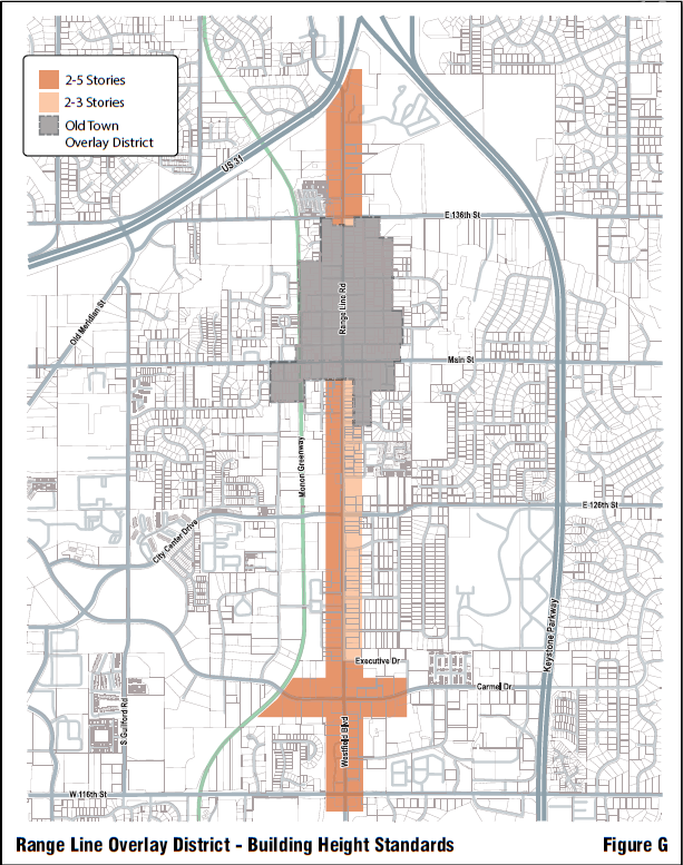
3.83 421-OL District Intent, Effect on Uses, Process and Applicability
| DistrictIntent | EffectonUses | Process andApplicability |
It is the purpose of the US 421 - Michigan Road Corridor Overlay District to promote
The US 421 - Michigan Road Corridor Overlay District further Seeks to foster development that will provide this district with a special sense of place that will increase property values, protect real estate investment, spur commercial activity, and attract new businesses. More specifically, the creation of this special sense of place shall be encouraged by means of a coordinated set of design principles for buildings, site planning, landscaping and signage. These principles are intended to guide individual development activities so that they will work together visually in support of the common architectural theme described herein. | Permitted Uses
Prohibited Uses
| Application Procedure
Property Applicability If the subject property is located partially inside and outside of the overlay district, then the entire property shall be subject to the overlay district regulations and its applicable processes.
Any development standard in Article 2: Zoning Districts or Article 5: Development Standards applicable to the subject property (base zoning district) shall apply unless this overlay district specifies a different standard. |
3.84 421-OL District Boundaries
The boundaries of the US 421 - Michigan Road Corridor Overlay District are hereby established as illustrated on the Official Zoning Map.
3.85 421-OL Exemptions
- There are no special exemptions related to this overlay district.
3.86 421-OL Interpretation
- There are no special interpretations related to this overlay district.
3.87 421-OL Accessory Building and Use Standards
- General Accessory Building and Use Standards: All Accessory Buildings and Uses which are permitted in the base zoning district(s) shall be permitted
- Architectural Compatibility Standards: Any detached Accessory Building shall be architecturally compatible with the Principal Building(s) with which it is associated.
3.88 421-OL Architectural Standards
- Design Theme: Buildings shall be designed with an overall Corridor Architectural Theme consistent with or complementary to the Federal, Georgian, Italianate, or Greek Revival Periods. New buildings are not required to be imitative, but shall incorporate the salient features of these architectural styles. Pre-existing buildings on adjoining tracts shall not be a factor in the design of new buildings unless they are consistent with the architectural objectives of the US 421 - Michigan Road Corridor Overlay District.
- Building Proportion: Buildings within the US 421 - Michigan Road Corridor Overlay District should generally avoid long, monotonous, uninterrupted walls or roof planes. The design and placement of building facades, doors, windows, and architectural design details shall be through use of Regulating Lines.
- Building Height: The height of new principal buildings shall be at least one and one-half (1½) stories, or be designed to appear so from the front and sides. Retail and office buildings are encouraged to be two (2) stories in height, with office or residential uses on the second floor. The minimum height for all buildings shall be twenty (20) feet, either at the roofline or at the top of the parapet wall. The maximum height shall be thirty feet (30’); however, an additional eight (8) feet shall be permitted to accommodate mechanical equipment, mechanical enclosures and screening, or other inner roof structures.
Building heights for proposed buildings that are adjacent to residential uses shall be no more than one and one-half (1½) stories or twenty (20) feet on the facade(s) nearest the residential use, but may increase in height by one additional story for a facade step back with a depth of twenty-five (25) feet, or first structural bay, whichever is larger.
D. Building Facades: Facades shall have a defined base or foundation, a middle or modulated wall, and a top formed by a pitched roof or articulated cornice, in each instance appropriate to the building style. Buildings with continu- ous facades that are ninety (90) feet or greater in width, shall be designed with offsets (projecting or recessed) not less than eight (8) feet deep, and at intervals of not greater than sixty (60) feet.
Facades constructed of more than one material shall only change materials along a horizontal line, or along a vertical line of an architectural element (not a diagonal line). The material that appears to be heavier shall always be placed beneath the lighter material. All facades of buildings shall be of the same materials and similarly detailed.
Design elements of the elevations shall be organized such that openings line up horizontally and vertically with other openings. Openings in a facade shall be arranged in a balanced, relatively uniform fashion. Openings of varying sizes are often centered vertically along the center line of the openings above or below.
E. Roofs:
- General: Roofs shall be simply and symmetrically pitched and only in the configuration of gables and hips, with pitches ranging from 4:12 to 14:12.
- Shed Roofs: Shed roofs are permitted only when the ridge is attached to an exterior wall of a building, and shall conform to pitch between 14:12 and 4:12.
- Flat Roofs: Flat roofs are permitted when consistent with the historic style of architecture, if edged by a railing or parapet, and if rooftop mechanical equipment is either camouflaged on all sides or visually integrated into the overall design of the building.
- Rooftop Mechanical Equipment: In no case shall rooftop mechanical equipment be visible from adjoining streets, residential districts or uses.
- Roof Design: Modulation of the roof and/or roof line will be required in order to eliminate box-shaped build-ings. Parapets shall be fully integrated into the architectural design of the building and provide seamless design transitions, including exterior materials, between the main building mass, mechanical equipment, mechanical enclosures and screening, and other roof structures. Should they be used, partial parapets shall have a return that extends inward to at least the first structural bay, or twenty-five (25) feet, whichever is greater.
- Roofing Material: Pitched roofs shall be clad in wood shingles, slate, composition asphalt shingle or stand- ing-seam metal panels. Asphalt shingles shall be colored to resemble gray slate; standing-seam panels may be either gray, black, dark blue, dark green or barn red.
- Dormers, Belvederes, Cupolas and Pergolas: Dormers shall be designed with the correct details, proportion and style consistent with the overall building composition, and roofed with symmetrical gable, hip or barrel roofs. Belvederes, cupolas, and pergolas are permitted if appropriate to the style, well proportioned, and fully detailed.
- Roof Vents and Other Roof Penetrations: All vents, attic ventilators, turbines, flues and others roof penetrations shall be painted to match the color of the roof or flat black, except those made of metal which may be left natural. Gutters and downspouts shall be appropriate to or visually integrated with the architectural style of the structure.
F. Entrances: Building entrances shall be defined and articulated by architectural elements such as lintels, pediments, pilasters, columns, and other design elements appropriate to the architectural style and details of the building as a whole. The location, orientation, proportion and style of doors shall faithfully reflect the chosen style of the building.
Building facades for industrial and warehouse uses shall be designed with a main entrance and at least two (2) window openings associated with this doorway.
G. Windows: All window design shall be compatible with the style, materials, color, details and proportion of the building. The number of panes, the way it opens, the trim around it and whether it is embellished with shutters shall be consistent with the architectural style of the structure.
H. Awnings: Fixed or retractable awnings are permitted if they complement a building’s architectural style, material, colors, and details; do not conceal architectural features (such as cornices, columns, pilasters, or decorative details); do not impair facade composition; and are designed as an integral part of the facade. Metal or aluminum awnings are prohibited.
I. Storefronts: Storefronts shall be integrally designed with overall facade character. Ground floor retail, service and restaurant uses should generally have large pane display windows, however, they shall not exceed seventy-five percent (75%) of the total ground level (first floor) facade area. Buildings with multiple storefronts shall be of unified design, through the use of common materials, architectural details, signage and lighting consistent with the overall building style.
J. Drive-thru windows: Drive-thru windows shall be designed as a related, integrated architectural element and part of the overall design composition of the building.
K. Suitability Of Building Materials: Unless otherwise approved by the Plan Commission, building materials shall be consistent with and/or complementary to those which replicate Federal, Georgian, Italianate and Greek Revival Periods of American architecture, as follows:
- Exposed foundation shall be constructed of one or more of the following:
- Red brick;
- Stone (limestone, granite, fieldstone, etc.);
- Split-face block or architectural pre-cast concrete, if surface looks like brick or stone.
2. Facade walls shall be constructed of any combination of red brick or stone. The following materials may also be applied as trim details, but shall not exceed ten percent (10%) of the overall non-window facade area:
- Red brick or stone of a contrasting color;
- Smooth cut cedar shingles;
- Wood clapboard siding;
- Wood beaded siding;
- Stucco with smooth finish, or EIFS.
3. Warehouse facilities, including self-storage and mini-warehouse uses, shall have a high-quality facade treat- ment on all sides consistent with the following:
- Red brick facades trimmed with split-faced aggregate block (of a color and texture resembling Indiana limestone), provided that it also includes accents (such as windowsills, lintels above windows and doorways, building corners, parapet coping, etc.).
- Split-face aggregate block (of a color and texture resembling Indiana limestone) provided that it also incorporates red brick accents.
- Precast concrete wall panels of a color and texture resembling either red brick or Indiana limestone, provided the building design also incorporates architecturally appropriate details of contrasting color and material, as noted previously in Section 3.88(K)(1) and Section3.88(K)(2).
- Stone or synthetic stone, provided the building design also incorporates architecturally appropriate details of contrasting color and material, as noted previously in Section 3.88(K)(1) and Section3.88(K)(2).
L. Design in relation to topography of the site;
M. Design of proposed landscaping in relation to structures; and
N. Overall aesthetics of the proposed building, including color.
3.89 421-OL Fence and Wall Standards
- Perimeter Fences: Perimeter Fences shall be permitted for privacy, buffering and screening purposes and shall be identified on the Development Plan. When used, perimeter fences shall be constructed of wood and masonry materials, be solid as viewed from any angle and shall be at least eight (8) feet in height. Primarily cedar fences are permitted; however, twenty-four (24) inch wide red brick or stone columns shall be incorporated into the fence design at least every twenty-six (26) feet. Alternatively, metal fencing with landscaping is permitted such that 100% landscaping screen is achieved within three (3) years. All fences shall be properly maintained and repaired, as necessary.
3.90 421-OL Height Standards
- Building Height:
- Minimum: See Section 3.88(C): Building Height.
- Maximum: As specified for the base zoning district.
3.91 421-OL Landscaping Standards
- Greenbelt:
- Greenbelt Width: A landscaped Greenbelt area shall extend along the Right-of-Way of U.S. Highway 421 with a minimum width of thirty (30) feet.
- Greenbelt Planting: A minimum base-planting unit for each 100 linear foot increment of the Greenbelt has been designated, as follows:
- Three (3) shade trees
- One (1) ornamental tree
- Parking Lot Perimeter Planting:
- Parking Lots along U.S. 421: Where parking areas are located in the Front Yard directly adjacent to U.S. 421, parking lot plantings shall be provided along the front and sides of those areas, within the greenbelt area.
- Minimum Planting: The required minimum base-planting unit for this area shall include: three (3) shade trees, one (1) ornamental tree, and thirty (30) shrubs per 100 linear feet.
3.92 421-OL Lighting Standards
- Lighting Plan: A Lighting Plan for the proposed development shall be filed as part of the ADLS application.
- Design:
- Lighting Standard: All lighting standards, including those on buildings, security lights and architectural lights within the development area shall be of uniform design and materials.
- Standard Height: Parking lot and streetlights shall also be of uniform height not to exceed twenty-four (24) feet.
- Minimum Pole Diameter: Poles for such lights shall have a minimum diameter of six (6) inches for poles up to twelve (12) feet in height and a minimum of eight (8) inches diameter for poles between twelve (12) and twenty-four (24) feet in height.
- Proportions: Luminaries for such lights shall be in proportion to the pole diameter and height.
- Gas Station Canopies and Lights Adjacent to Residential: All lights within gas station canopies and adjacent to residential areas shall be of a “down lighting” type with the light element completely shielded on all sides and top.
- Decorative Lighting: The Plan Commission may approve decorative lighting should it be more appropriate to the overall site design.
- Intensity: Lighting shall not cause illumination beyond any residential lot line or road right-of-way line in excess of 0.1 foot-candle of light. Lighting shall not cause illumination beyond any non-residential tract or parcel line or road right-of-way line in excess of 0.3 foot-candle of light.
3.93 421-OL Lot Standards
- Minimum Tract Size:
- The minimum area covered by a Development Plan within the US 421 - Michigan Road Corridor Overlay District shall be 130,680 square feet (3 acres). For tracts located only partially within the US 421 - Michigan Road Corridor Overlay District, a Development Plan shall be submitted to the Plan Commission for the entire tract to be developed.
- If a parcel of land or subdivision lot was recorded prior to September 7, 1988 (the “Effective Date”), and said parcel or lot does not contain the minimum area required by this Paragraph, said parcel or lot (“Undersized Lot”) may be used for any use permitted in the US 421 - Michigan Road Corridor Overlay District provided that:
- At the time of recordation of the Undersized Lot or on the Effective Date, the Undersized Lot met the requirements for minimum lot size then in effect for a lot in the base zoning district(s);
- The owner of the Undersized Lot shall include, up to the minimum tract size, any adjoining vacant land (not separated by a street or public way) owned, or owned by an affiliate, on or before the Effective Date or at the time of application which, if combined with the Undersized Lot, would create a tract which conforms, or more closely conforms, to the minimum tract size requirements of this Paragraph; and
- All other development requirements applicable to the Overlay District can be met.
- This Paragraph does not preclude the sale or other transfer of any parcel of land within a tract after the approval of a Development Plan for the entire tract. However, the development of the parcel shall still conform to the Development Plan for the entire tract as approved or amended by the Plan Commission, and all other applicable requirements contained in the Unified Development Ordinance.
3.94 421-OL Outdoor Display Standards
- Outdoor sales and outdoor displays are prohibited uses in the US 421 - Michigan Road Overlay District.
3.95 421-OL Parking Standards
- Spaces Required: See Section 5.28: General Parking Standards.
- Space Dimensions: 9’0” x 20’0” or 10’0” x 18’0”, plus 2’0” for bumper overhang where appropriate.
- Parking lots shall be designed to provide coordinated access to parking areas on adjoining tracts or parcels within the US 421 - Michigan Road Corridor Overlay District, preferably via a frontage road network. Sites utilizing front-loaded parking areas shall provide for continuous access across the rear of the site to adjoining tracts or parcels. As part of the ADLS submittal, the petitioner shall provide a Site Circulation Plan that illustrates to the Plan Commission how coordinated access will occur relative to the overall US 421 - Michigan Road Corridor.
- All parking lots and drives shall be paved with asphalt or concrete. Brick pavers or other decorative pavements may be used as accents in parking lot design. Poured-in-place concrete curbs shall be used.
- Parking within front yard setbacks shall be discouraged and limited to a maximum of two (2) rows of parking, subject to maximum building setback standards and Section 5.19: Commercial Landscaping Standards.
- Stacking for drive-thru lanes shall be confined to the rear of the tract or parcel with outlet from such lines also being to the rear of the building. Lines for drive-thru facilities shall not be permitted along the front and sides of structures within the Overlay District, nor permitted to spill onto adjoining properties. The minimum number of vehicles required for drive-thru lanes shall be as follows:
| Use Type | Min. Number of Spaces | Measured From |
| Bank teller lane | 5 | Teller or Window |
| Automated Teller Machine | 3 | Teller |
| Restaurant Drive-thru | 10 | Pick-up Window |
| Car Wash | 5 | Entrance |
| Gas Pump island | 3 | End of pump island |
| Other | To be determined by the Director of Community Services |
3.96 421-OL Setback Standards
- Front Yard for Parcels with Frontage on US 421 - Michigan Road Right-of-way:
- Minimum: Thirty (30) feet, measured from the US 421 - Michigan Road right-of-way. This measurement shall include the mandatory thirty-foot (30’) Greenbelt.
- Maximum: 120 feet, measured from the US 421 - Michigan Road right-of-way. This measurement shall include the mandatory thirty-foot (30’) Greenbelt.
- Minimum Side and Rear Yards:
- Next to Existing Residence(s) or Undeveloped Residential District: Fifty (50) feet or two (2) times building height, whichever is greater.
- Next to Business District or Development: Fifteen (15) feet.
- Next to Industrial District or Development: Twenty (20) feet.
3.97 421-OL Sign Standards
- See the applicable base zoning district’s regulations. No overlay-specific standards apply.
3.98 421-OL Site Design Standards
- Access to Individual Tracts: The purpose of this subsection is to make the closing of all curb cuts along US 421 - Michigan Road possible by establishing a common access road to the rear parking lots of all tracts within the Overlay District. Frontage roads and common entrances shared by several businesses and developments shall be encouraged and may be required at the discretion of the Plan Commission. In those cases where tracts can be accessed via connection to an arterial street, local street, or adjoining parking lot, curb cuts shall not be established on US 421 - Michigan Road. The Plan Commission shall encourage maximum distances between curb cuts to US 421 - Michigan Road in cooperation with the Indiana Department of Transportation. Bicycle and pedestrian circulation to and through the site shall be coordinated with vehicular access, Greenbelt design, and parking.
3.99 421-OL Structure Standards
- Minimum Gross Floor Area: Each lot or parcel shall contain at least one principal building with a minimum of 2,500 square feet of gross floor area, excluding the floor area of any basement or any accessory buildings. Accessory buildings need not meet the minimum floor area requirement.
- Maximum Gross Floor Area: All free-standing commercial buildings located north of 106th Street shall have a maximum of 85,000 square feet of gross floor area, excluding the floor area of any basement or any accessory buildings.
3.100 421-OL Other Standards
- Outside Storage: Outside storage areas shall be allowed as shown on the Development Plan and shall be architec- turally compatible with the principal building(s) with which they are associated. Storage areas shall be completely screened from view and subject to Plan Commission approval. Trash collection areas shall be enclosed and screened.
- Loading Berths: Loading berths and trash collection areas shall be permitted per the needs of the business estab- lishments and shall be identified on the Development Plan. Loading berths and overhead doors shall face to the rear of all buildings. Should a loading berth be located adjacent to or visible from a public right-of-way, or established on the side of a building through any circumstance, it shall be screened per Plan Commission approval.
- Emergency Access: All emergency access areas and facilities shall be shown on the Site Plan and reviewed by the Carmel Fire Chief.
3.101 116-OL District Intent, Effect on Uses, Process and Applicability
| DistrictIntent | EffectonUses | Process andApplicability |
| The purpose of the West 116th Street Overlay District is to protect the estate character of the area. the West 116th Street Overlay District is superimposed over base zoning districts and its regulations shall supersede those of the base zoning districts over which it is superimposed. The Plan Commission and Common Council, in establishing this overlay district, are relying onIC 36-7-4-100 etseq. | Permitted Uses
Special Uses
Prohibited Uses
| Application Procedure
Property Applicability Portions of parcels extending beyond a depth of greater than or equal to 990 feet from the center line of 116th Street are exempt from the requirements of the West 116th Street Overlay District. Development Standards Applicability Any development standard in Article 2: Zoning Districts or Article 5: Development Standards applicable to the subject property (base zoning district) shall apply unless this overlay district specifies a different standard. |
3.102 116-OL District Boundaries
The boundaries of the West 116th Street Overlay District are hereby established as illustrated on the Official Zoning Map.
3.103 116-OL Exemptions
- Parcels in the P1 District shall be exempt from the requirements of the West 116th Street Overlay District.
- Parcels in subdivisions platted on or before April 18, 2005 shall be exempt from the requirements of the West 116th Street Overlay District.
3.104 116-OL Interpretation
- There are no special interpretations related to this overlay district.
3.105 116-OL Accessory Building and Use Standards
- See the applicable base zoning district’s regulations. No overlay-specific standards apply.
3.106 116-OL Architectural Standards
- See the applicable base zoning district’s regulations. No overlay-specific standards apply.
3.107 116-OL Fence and Wall Standards
- See the applicable base zoning district’s regulations. No overlay-specific standards apply.
3.108 116-OL Height Standards
- See the applicable base zoning district’s regulations. No overlay-specific standards apply.
3.109 116-OL Landscaping Standards
- See the applicable base zoning district’s regulations. No overlay-specific standards apply.
3.110 116-OL Lighting Standards
- See the applicable base zoning district’s regulations. No overlay-specific standards apply.
3.111 116-OL Lot Standards
- Minimum Front Yard: 100 feet.
- Minimum Lot Area: No new lot may be created with an area less than three (3) acres.
- Parcels in the West 116th Street Overlay District shall not qualify for any density bonus which may be permitted through the subdivision control regulations.
3.112 116-OL Outdoor Display Standards
- See the applicable base zoning district’s regulations. No overlay-specific standards apply.
3.113 116-OL Parking Standards
- See the applicable base zoning district’s regulations. No overlay-specific standards apply.
3.114116-OL Setback Standards
- See the applicable base zoning district’s regulations. No overlay-specific standards apply.
3.115 116-OL Sign Standards
- See the applicable base zoning district’s regulations. No overlay-specific standards apply.
3.116 116-OL Site Design Standards
- See the applicable base zoning district’s regulations. No overlay-specific standards apply.
3.117 116-OL Structure Standards
- See the applicable base zoning district’s regulations. No overlay-specific standards apply.
3.118 116-OL Other Standards
- See the applicable base zoning district’s regulations. No overlay-specific standards apply.
Figure C: Old Town Overlay District and Sub Areas
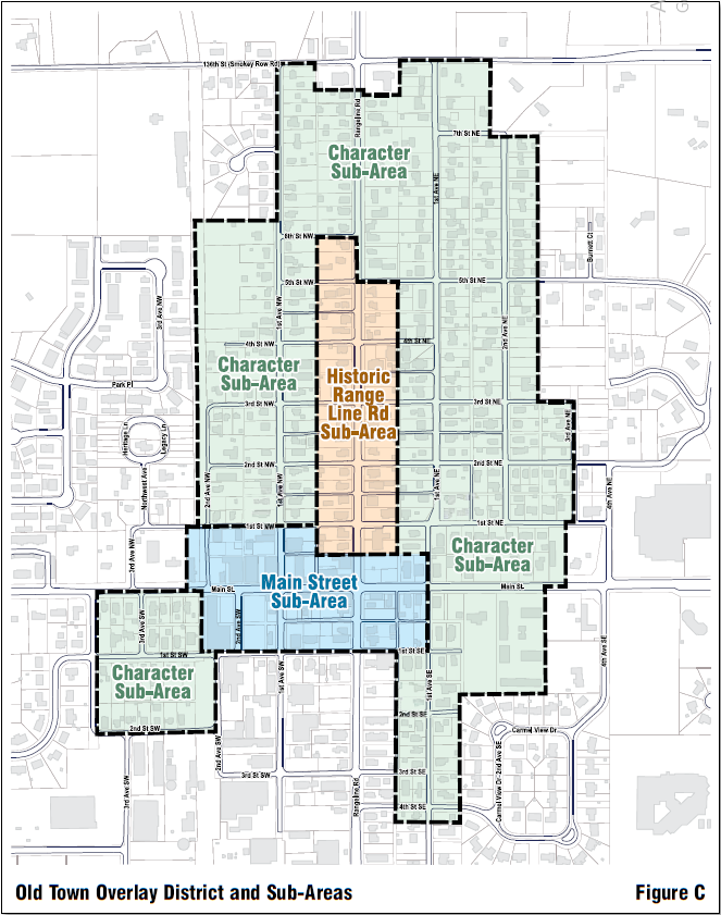
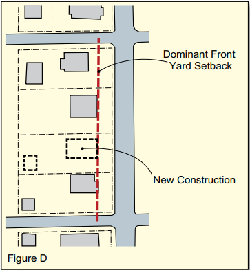
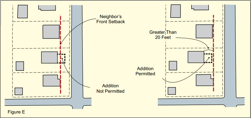
Figure F: Old Town Character Buildings