
Carmel City Zoning Code
ARTICLE 7
Design Standards
7.01 Using This Article
The following pages contain the design standards for subdivision approval. One or more sections are used to regulate each category of design standards. There are two ways to determine which design standards apply to a specific type of subdivision. They are:
- Using Two-Page Layouts: Refer to the two-page layouts in Article 6: SubdivisionTypes for the applicable and desired subdivision type. Applicable design standards for that specific subdivision type are identified by four-digit codes in the "Additional Design Standards that Apply." Only the four-digit codes noted in the "Additional Design Standards that Apply" section apply to that subdivision type.
Using Icons: Refer to the icons used at the beginning of each design standards section in Article 7: Design Standards. Each design standard section begins with a four-digit code and introductory sentence followed by square icons that represent each subdivision type. These project icons note that the design standards written in that section applies to that type of subdivision.
7.02 Purpose of Design Standards
- Intent: It is the purpose of Article 7: Design Standards to establish and define design standards that shall be required by the City of Carmel for the subdivision of land.
7.03 Icon Key
| SS | Simple Subdivision |
| CS | Conservation Subdivision |
| RS | Residential Subdivision |
| TS | TownhouseSubdivision |
| CM | Commercial Subdivision |
7.04 AD-01: Residential Architectural Diversity (AD) Standards
This Architectural Diversity (AD) Standards section applies to the following types of development:
| CS | RS |
- Applicability: Any residential subdivision with ten (10) lots or greater and internal streets shall comply with the regulations in this section.
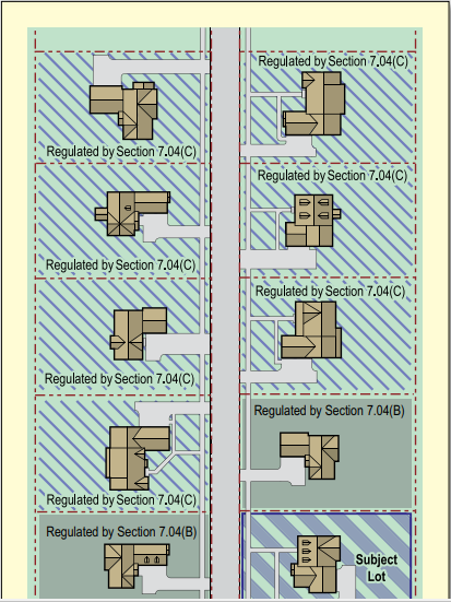
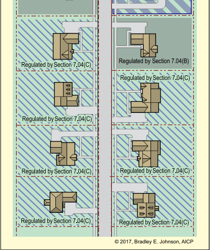
- Floor Plan Duplication Restriction: No two (2) adjacent principal buildings shall have the same floor plan. The illustration below highlights the lots considered adjacent to the subject lot. Mirror images of a floor plan or incidental alterations to a floor plan shall not constitute a unique floor plan. Additionally, the following number of unique floor plans shall be required:
- 10 to 29 Lots: At least four (4) unique floor plans shall be used.
- 30 to 49 Lots: At least six (6) unique floor plans shall be used.
- 50 Lots or Greater: At least eight (8) unique floor plans shall be used.
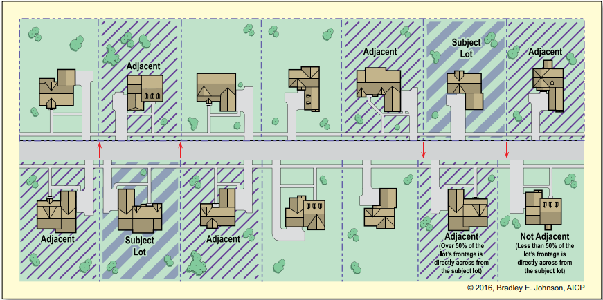
- Front Elevation: If a principal building within four (4) lots of the subject lot has the same floor plan, it shall not have the same front elevation design. The facade materials, architectural treatments, garage orientation, and/or roof design shall be notably different. Mirror images of the subject lot’s floor plan, brick color change, paint color change, or minor alterations to the floor plan shall not constitute a unique front elevation, but are encouraged to further create a non-duplicative look. The illustration below highlights the lots that cannot have the same front elevation. Note that Section 7.04(B): Floor Plan Duplication Restriction does not allow adjacent lots to have the same floor plan, even if the facade is notably different.
 |
 |
7.05 AD-02: Townhouse Subdivision Diversity (AD) Standards
This Architectural Diversity (AD) Standards section applies to the following type of development:
| TS |
- Applicability: Any townhouse development shall comply with the regulations in this section.
- Floor Plan Restriction: At least four (4) unique floor plans shall be used throughout any townhouse development; with at least two (2) unique floor plans per multiple-unit building. Mirror images of a floor plan or incidental alterations to a floor plan shall not constitute a unique floor plan.
- Primary Elevations, Large Developments: Townhouse developments with four (4) or more multiple-unit buildings shall have diversity in elevations such to avoid a “cookie cutter” or repetitive aesthetic throughout the development. Diversity in building elevations shall be from building-to-building. Diversity shall be achieved through differences in architectural features, siding material changes, masonry variations, brick color changes, paint color changes, entryway feature changes, window variations, and/or roof design. Cumulatively, changes in these features shall clearly distinguish one building from one another, yet be complementary of one another. Further, no single building facade design shall be used more than forty percent (40%) of the time throughout the development.
- Primary Elevations, Small Developments: Townhouse developments with three (3) or less multiple-unit buildings shall have diversity in individual facades for each unit such to avoid a “cookie cutter” or repetitive aesthetic for any single building. Diversity in unit elevations shall be achieved through multiple differences in any of the following:architectural features, setback offsets,
siding material changes,
masonry variations,
brick color changes,
paint color changes,
entryway feature changes,
window variations, and/or
roof design.
Cumulatively, changes in these features shall clearly distinguish one unit facade from the others, yet be comple- mentary of one another. Further, no single facade design for a unit shall be used more than forty percent (40%) of the time throughout the development.
E. Alternative Compliance: An applicant may Seek to not follow the requirements above in Section 7.05(C): Primary Elevations, Large Developments or Section 7.05 (D): Primary Elevations, Small Developments, but instead submit sufficient, detailed, color facade drawings that clearly meets or exceeds the intent of those architectural standards. The architectural alternative design, if approved, shall be legally binding to the applicable townhouse buildings. The submitted facade drawings must be reviewed and approved by the Planning Adminstrator. If the proposed alternate design is not determined to clearly meet or exceed the intent of the architectural diversity standards it shall be denied and then the applicable prescribed standards in Section 7.05(C): Primary Elevations, Large Developments or Section 7.05 (D): Primary Elevations, Small Developments shall apply. If denied by the Planning Administrator, the applicant may petition the Plan Commission for the same alternate design at a regularly schedule meeting. The Plan Commission may approve or deny the proposed alternate design. Any approved alternate design shall be recorded with the title of each lot within the subdivision.
7.06 CA-01: Common Area (CA) Standards
This Common Area (CA) Standards section applies to the following types of development:
| CS | RS | TS | CM |
- Cross Reference:
- Storm Drainage: Under no circumstances shall perimeter landscaping impede drainage.
- Perimeter Landscaping: See Perimeter Landscaping in Section 7.23: Perimeter Landscaping Standards for additional regulations that relate to Common Area.
- Bufferyards: See Perimeter Landscaping in Section 7.23: Perimeter Landscaping for more information on how bufferyards requirements in Article 5: Development Standards may be met with perimeter landscaping.
- Landscape Installation and Maintenance: See Article 5, Section 5.19: Commercial Landscaping Standards. The landscape installation and maintenance regulations apply to all landscaping in common areas.
- Designation: Developments that are required to or elect to have: perimeter landscaping, open space, conservation areas, detention basins, retention ponds, drainage ways, parking lots, private streets, alleys, amenity centers, or similar features shall designate those areas as common area. An easement may be allowed instead of common area in some circumstances. However, that easement shall be maintained in perpetuity like common area.
- Common Area Ownership, Operation and Maintenance: All common area shall be owned, operated and maintained in perpetuity by an owners’ association, condominium association, or similar legal binding instrument. A legally binding instrument shall be utilized to collect fees to maintain all common areas as originally designed, committed to, and officially approved.
- Notification: A legal representative of the property owners of common area shall notify the Planning Administrator of any proposed changes, except as described in Section 7.06(F): Managing Landscaping and Entryway Features within the Common Area. After notification, the Planning Administrator may or may not review and/or inspect the proposed plans based on the scope of the project and potential for non-compliance. No permit is required, but the Planning Administrator shall render an interpretation that the proposed changes remain in the spirit of and in compliance with the original approval.
- Modifying Features within Common Area: A proposed modification to the character, features, structures, drainage, or an engineered system in a common area shall be subject to Planning Administrator and City Engineer review. Proposed changes that are clearly incidental and/or that clearly meet or exceed the original design, applicable commitments, applicable conditions, and final approval, at that time of platting, shall be approved by the Planning Administrator and City Engineer. Any proposed change deemed by the Planning Administrator or City Engineer to not be incidental or a clear change to the original design, applicable commitments, applicable conditions, and final approval, at the time of platting shall require a plat amendment (i.e. replat) and is subject to Plan Commission approval as a replat.
- Managing Landscaping and Entryway Features within the Common Area: The following actions do not need Planning Administrator review.
- Exempt Direct Replacement: Required landscaping that was installed within common area may be removed if:
- Diseased or Dead: If diseased or dead landscaping is removed, the same or similar plant shall be installed as a replacement in the same or nearby location. Said replacements shall be as large as can reasonably be installed. Evergreen trees shall only be used to replace evergreen trees and shrubs shall only be used to replace shrubs. In all cases, a native deciduous tree, evergreen or shrub may be used to replace a non-na- tive of the same type.
- Overgrown: Trees or shrubs that pose a risk to nearby quality vegetation or utilities, block necessary visibility, or otherwise impact public health or safety may be removed. The same or similar plant may be installed as a replacement in the same or nearby location; however, effort should be made to not perpetuate the same issue. In all cases, a native deciduous tree, evergreen or shrub may be used to replace a non-na- tive of the same type.
- Exempt Additions to Landscaping: Modest, non-evergreen, additions to existing landscaping may be added to common areas as long as it is outside an easement that precludes such plantings. Said additions to plant material shall not constitute a modification to the plat.
- Exempt Entryway Feature Replacement or Repair: If by accident or act of nature an entryway feature structure is damaged or deteriorates over time, maintenance may be conducted to keep those features aesthetically pleasing. A severely damaged or destroyed entryway feature may be replaced with a substantially similar structure may be installed. This exemption does not exempt current and applicable building, plumbing or electrical codes that may apply.
- Exempt Direct Replacement: Required landscaping that was installed within common area may be removed if:
- Landscape Installation and Maintenance: The landscape installation and maintenance regulations in Article 5, Section 5.19: Commercial Landscaping Standards apply to all landscaping in common areas.
7.07 DD-01: Dedication of Public Improvement (DD) Standards
This Dedication of Public Improvement Standards (DD) section applies to the following types of development:
| CS | RS | TS | CM |
- Applicability: The following regulations shall apply to any subdivision that intends to dedicate infrastructure or other improvement to the City of Carmel or other public entity.
- Non-dedicatable Facilities: The City of Carmel shall not be dedicated any alley, driveway, drive aisle, parking lot, unusual on-street parking spaces, private streets, or similar development feature unless:
- Public Interest: There is a public interest,
- Construction: The facility is constructed to City of Carmel Engineering Standardsand verified as such by the City Engineer, and
- Approval: The Board of Public Works approves the acceptance.
- Dedication of Right-of-way: The right-of-way illustrated on an approved final plat shall be considered dedicated upon Final Plat approval by the Plan Commission.
- Establishment of Easement: An easement in favor of the City of Carmel or other public entity illustrated on an approved final plat shall be considered established upon final approval by the Plan Commission.
- Construction and Maintenance of Public Infrastructure: The developer shall install streets, street features, landscaping and pedestrian facilities within the public right-of-way per the City of Carmel Engineering Standards, applicable standards for the subdivision type found on the two-page layouts in Article 6: SubdivisionTypes, and according to Article 7: Design Standards for the applicable subdivision type. The maintenance of such facilities shall be the sole responsibility of the property owner(s) of the subdivision until the right-of-way improvements are approved and dedicated to the City.
- Maintenance Surety: A maintenance bond shall be required per Section 7.36: Surety Standards, prior to dedication of any public infrastructure.
- Dedicated Utilities: All utilities (e.g. sanitary sewer, water) installed per a private or public utility’s engineering standards, excluding private laterals, shall be dedicated to the appropriate entity at any time after their installation and after the City of Carmel accepts the street installation.
- Other Facilities: Other infrastructure, land or facilities may, at the election of the Common Council, be dedicated to the City. These facilities may include parks, open space, street lighting, or other facilities in which the public may have substantial interest.
7.08 DN-01: Development Name Standards
This Development Name Standards (DN) section applies to the following types of development:
| SS | CS | RS | TS | CM |
- Proposed Development Name: The applicant shall propose a unique name for the development.
- Root Name: The proposed root name of the development shall not duplicate, or closely resemble phonetically, the name of any other development within the planning jurisdiction (for example, if Windemere Subdivision exists, the name Windermere Subdivision shall not be permitted). The Planning Administrator may reject root names that duplicate or closely resemble a development’s name outside the City’s planning jurisdiction if deemed relevant (e.g. Centennial may be restricted to be used in Carmel due to its use in Westfield).
- Prefix or Suffix Name: Deviations in a prefix or suffix name (e.g. Estates at, Place, Woods, or Glen) shall not constitute a unique name (for example, if Preston Place exists, the name Preston Woods shall not be permitted). However, the following provision for large developments gives a discretionary opportunity to use the same root name.
- Large Developments: Unique subareas within a large development or separate developments within close proximity may be authorized to use the same root name by the Plan Commission. For example, if a residential development has different price point products, they may be permitted to use Woodhaven Place for one subdis- trict and Woodhaven Estates for another.
- Administrative Review of Development Names: A proposed development name shall be reviewed by a Planning Administrator in coordination with Hamilton County’s 911 Communications Department to determine compliance with 911 initiatives.
- Approval Authority: The Plan Commission has full discretionary authority to approve or deny any proposed name for any reasonable purpose per State Statute. If the Plan Commission rejects a proposed development name, the applicant may propose a new name until an acceptable name is determined. If an acceptable and unique devel- opment name is not proposed by the applicant, the Plan Commission delegates to the Planning Administrator the power to determine a development name for the development prior to final plat approval.
- Renaming Authority: Existing development names or development names that have been previously approved by the Plan Commission shall not be changed without Plan Commission approval.
7.09 DU-01: Development Utility Standards
This Development Utility Standards (DU) section applies to the following types of development:
| CS | RS | TS | CM |
- Location: All utilities shall be installed underground in designated utility easements or right-of-ways if permitted by the City of Carmel Board of Public Works.
- Utility Easement Standard:
- Minimum Width: Utility easements shall have a minimum width of twenty (20) feet and may include multiple utilities.
- Maximum Width: Utility easements shall not be any greater than absolutely necessary, nor shall they constrain use of property greater than absolutely necessary.
- Location: Utility easement shall run parallel and be contiguous with a right-of-way; or located along lot lines, where one-half (1/2) of the width is taken from each lot, or as close to such a standard as practicable. In urban environments, utilities may be permitted fully or partially within the right-of-way when an easement outside the right-of-way is not feasible and when the Board of Public Works and City Engineer support the utility in the right-of-way. Utilities in traditional neighborhoods shall strive to locate all electric and telecommunication utilities in alleys. Common areas may also be used for utility easements when they do not conflict or overly restrict drainage design or landscaping.
- Walls: Utility easement shall not restrict walls running perpendicular to an easement when the wall is a permitted structure otherwise, but may restrict walls running parallel within the easement. Easements may include clauses that when unavoidable circumstances require the wall to be removed, that it shall be removed at the owner’s expense and reinstallation of the wall will be at the owner’s expense. Non-emergency maintenance of utilities shall give property owners a minimum of fourteen (14) days notice to remove the wall. Emergency maintenance shall require no notice.
- Fences: Utility easement shall not restrict fences to be installed, but may include clauses that fences may be removed at the owner’s expense and reinstallation of the fence will be at the owner’s expense. Non-emergency maintenance of utilities shall give property owners a minimum of five (5) days notice to remove any obstruc- tions. Emergency maintenance shall require no notice.
- Landscaping: Utility easement shall not restrict reasonable and appropriate landscaping, but may include clauses that landscaping may be removed at the owner’s expense and reinstallation of landscaping will be at the owner’s expense. Non-emergency maintenance of utilities shall give property owners a minimum of five (5) days notice to remove any obstructions. Emergency maintenance shall require no notice.
- Drainage Easements: Utility easements may be shared with drainage easements, but only when it would cause no obstruction to the watercourse or flow of surface water or impede the function of a Best Management Practice.
- Pedestrian Facilities: Paths, sidewalks and public access shall not be prohibited by a utility easement. Only the underlying ownership prohibits such facilities and access.
- Sanitary Sewer Standards: All subdivisions shall provide for the collection of all sanitary waste by installing sanitary sewers per the specifications of the applicable sanitary sewer utility and City Engineering Standards. These sanitary sewers shall be tied into a sanitary sewer treatment system.
- Water Service Standards: All subdivisions shall provide for the distribution of potable water and a fire protection system by installing water lines per the specifications of the applicable water utility, fire department, and City Engineering Standards.
- Storm Sewer Standards: All subdivisions shall provide for the filtering and restricted release of storm water through a storm water collection and storage system, infiltration, and/or green infrastructure. See Section 7.35: Storm Water and Erosion Control Standards for more information.
- Electric and Telecommunications: All subdivisions shall provide electric service and telecommunication lines to each lot. Telecommunications should include cable, telephone and fiber allowing property owners multiple choices of carriers. Limiting any type of telecommunication by contract or other means shall not be permitted.
- Gas Utility: All subdivisions shall provide natural gas to an easement or right-of-way adjacent to each lot if reasonably available.
- Up-Sizing Policy: Certain public utilities constructed by the developer of a particular subdivision may also be of benefit to other areas of the City. When this is the case, the City may, upon request of the petitioner, enter into contractual agreements which shall provide for proportional cost recovery of the installed utility. These agreements shall be in accordance with the appropriate Indiana Statutes; and the cost for preparing any and all exhibits, studies, and legal services shall be proportionately shared by the applicant and City. In all cases, the appropriate agreements shall be prepared and executed prior to the start of construction of any utility that is eligible for this construction cost credit.
7.10 EA-01: Easement Standards
This Easement Standards (EA) section applies to the following types of development:
| SS | CS | RS | TS | CM |
- Cross-Reference:
- Private Street Easements: For details concerning private street easements, See Section 7.26: Private Street Standards.
- Temporary Turnaround Easements: For details concerning temporary turnaround easements, See Section 7.25: General Street Standards.
- Utility Easements: For details concerning utility easements, See Section 7.09: Development Utility Standards.
- Landscape Easement: For additional information concerning landscape easements, See Section 7.11: Residential Entryway Feature Standards, Section 7.12: Non‑Residential Entryway Feature Standards, and Section 7.23: Perimeter Landscaping Standards.
- Cross-access Easements:
- Description: A cross-access easement applies to shared driveways, shared access, access to otherwise land- locked parcels and shared parking lots.
- Instrument Specifications: When applicable, each property owner of record shall execute a cross-access easement instrument in favor of the adjoining property owner. The cross-access easement instrument shall be signed by the owner or an authorized representative of the owner of all associated properties. The cross-access easement instrument shall include the following language:
- Identify the development name with which the cross-access easement (CAE) is associated.
- When applicable, the cross-access easement (CAE) shall grant the general public the right to utilize the easement for purpose of accessing adjoining parking lots.
- The cross-access easement (CAE) shall prohibit any person from parking vehicles within the easement, unless the cross-access easement (CAE) is designed for parking.
- The cross-access easement (CAE) shall prohibit any person, including the property owner, from placing any obstruction within the easement.
- The cross-access easement (CAE) shall be binding on all heirs, successors, and assigns to the property on which the cross-access easement is located.
- The cross-access easement (CAE) shall be enforceable by the owners of each associated property, the City of Carmel, and any other specially affected persons identified in the cross-access easement.
- The cross-access easement (CAE) shall provide for modification or termination in a manner specified in the Unified Development Ordinance.
- The cross-access easement (CAE) shall be cross-referenced to the most recently recorded deeds of the associated properties.
- The cross-access easement (CAE) shall include a metes and bounds description of the easement.
- Cross‑access Easement Certificate:
- When a final plat is being recorded, the applicant may forego a separate cross-access easement instrument in favor of printing the following “Cross-access Easement Certificate on the recordable instrument: Areas on these plans designated as a ‘Cross-access Easement’ or abbreviated as ‘CAE’ are established in favor of the adjoining property owner(s), and grant the public the right to enter the easement for purposes of accessing the adjoining property. These easements prohibit any person from parking vehicles within the easement, and prohibit the property owners or any other person from placing any obstruction within the easement. These easements are binding on all heirs, successors, and assigns to the property on which they are located. The grantee or the City of Carmel may enforce the provisions of the easement. The easement shall only be modified or vacated in the manner stipulated in the Unified Development Ordinance, or its successor ordinance.”
- The dedication and acceptance of any cross-access easements shown on a recordable instrument shall be accomplished via a Certificate of Dedication and Acceptance signed by the appropriate property owners, or their agents.
- If the Declaration of Covenants is included on the recordable instrument, the cross-access easement certificate shall clearly be separate from the Declaration of Covenants.
- Landscape Easements:
- Description: A landscape easement applies to required landscaping in a subdivision in-lieu-of that landscaping being located in common area.
- Prerequisite for Required Landscaping: The use of landscape easements for landscaping required by Section 7.23: Perimeter Landscaping is not permitted by right. The Plan Commission must authorize the use of landscape easements (See Section 7.23(E): Ownership), otherwise all required landscaping shall be installed in the more traditional common area.
- Prerequisite for Elective Landscaping: Landscape easements may be used for any elective landscape areas intended to benefit the neighborhood, development, and/or general public.
- Instrument Specifications: When a landscape easement is elected for and allowed by right or by permission by the Plan Commission, the property owner of record shall execute the landscape easement instrument in favor of the City of Carmel. The landscape easement instrument shall be signed by the property owner of record granting the easement and an authorized representative of the City of Carmel. The landscape easement instrument shall include the following language:
- Identify the property with which the landscape easement is associated.
- Specify and describe the activities the property owner and other entities are authorized to perform in the landscape easement. This description shall include:
- Normal and common maintenance and treatment that improves health of plant material, maintains the designed aesthetic, or extends the serviceable life of landscape features (e.g. fence or wall).
- Required maintenance of irrigation system (if applicable).
- Specify and describe the activities the property owner and other entities are prohibited from performing in the landscape easement. This description shall include:
- Be binding on all heirs, successors, and assigns to the property on which the landscape easement is located.
- Be enforceable by the City of Carmel.
- Provide for modification in the manner stipulated in the Unified Development Ordinance.
- Be cross-referenced to the most recently recorded deed to the property on which the easement is to be established.
- Include a metes and bounds description of the landscape easement.
- Drainage Easements: Where a proposed subdivision is traversed by any stream, watercourse, or drainageway, the subdivider shall make adequate provision for the proper drainage of surface water, including the provision of easements along such streams, watercourses, and drainageways, in accordance with the standards established by the City.
- Best Management Practice (BMP) Easement:
- BMP Easement Agreement:
- Projects that shall install storm water Best Management Practices to comply with the City's Storm Water Ordinance and Technical Standards Manual shall provide a BMP Easement over these facilities and provide one of the following:
- BMP Easement Agreements or Certificates shall be cross referenced in any covenants and restrictions as well as including language detailing the maintenance responsibilities and rights of access to said areas.
- BMP Easement Agreement:
- Water Quality Preservation Easements: Any lot abutting or containing a natural lake, stream or wetland shall establish a Water Quality Easement per the following regulation:
- Natural Lake: From the normal pool elevation of the natural lake, a twenty-five foot (25’) wide Water Quality Preservation Easement shall be established. This easement shall be designated and restricted as a “no-build,” “no-disturb” zone (i.e. not allowing man-made structures, changes in grade, plant material installation, or hardscape features to be constructed or placed on or in that area), excluding plant material permitted by the Planning Administrator. Turf grass shall not be planted or maintained in this easement, nor shall fertilizer, herbicide or insecticide of any type be applied. Rather, native plants shall be maintained. Up to twenty percent (20%) of the entire boundary with the natural lake may be managed such that access can be gained to the water’s edge. However, this does not permit man made materials, gravel, sand, or turf grass to be used to provide that access. A minimally invasive boardwalk, stepping stones, or mowed/trimmed native grasses may be used when approved by the Planning Administrator.
- Wetlands: From the delineated boundary of a wetland, a fifty foot (50’) wide Water Quality Preservation Easement shall be established. This easement shall be designated and restricted as a “no-build,” “no-disturb” zone (i.e. not allowing man-made structures, changes in grade, plant material installation, or hardscape features to be constructed or placed on that area), excluding plant material permitted by the Planning Administrator. Turf grass shall not be planted or maintained in this easement, nor shall fertilizer, herbicide or insecticide of any type be applied. Rather, native plants shall be maintained.
- Stream: The entire floodway fringe, as delineated, plus an additional twenty-five (25) feet of buffer shall be established as a Water Quality Preservation Easement. This easement shall be designated and restricted as a “no-build,” “no-disturb” zone (i.e. not allowing man-made structures, changes in grade, plant material installa- tion, or hardscape features to be constructed or placed on or in that area), excluding plant material permitted by the Planning Administrator. Turf grass shall not be planted or maintained in this easement, nor shall fertilizer, herbicide or insecticide of any type be applied. Rather, native plants shall be maintained. Up to ten percent (10%) of the entire boundary with the stream may be managed such that access can be gained to the water’s edge. However, this does not permit man made materials, gravel, sand, or turf grass to be used to provide that access. Stepping stones, or mowed/trimmed native grasses may be used when approved by the Planning Administrator.
- White River: A 100 foot wide buffer shall be preserved, measured from the water’s edge at normal elevation. See Open Space Standards for more information.
- Other Easements:
- Instrument Specifications: When an easement is required by the Unified Development Ordinance or an easement is required per a commitment or condition of approval, but the standards for the easement type are not specified, the property owner of record shall execute the easement instrument in favor of the appropriate parties (e.g. the general public, City of Carmel, utility or specific abutting property owner). The easement instrument shall be signed by the property owner of record granting the easement and an authorized representa- tive of the appropriate party(ies) accepting the easement. The easement instrument shall include the following language:
- Identify the property or development name with which the easement is associated.
- Specify and describe those activities the appropriate parties are authorized to perform in the easement.
- Specify and describe those activities the property owner of record is prohibited from performing in the easement.
- Be binding on all heirs, successors, and assigns to the property on which the easement is located.
- Be enforceable by the property owner of record, any appropriate parties, and the City of Carmel.
- Provide for modification in the manner stipulated in the Unified Development Ordinance.
- Be cross-referenced to the most recently recorded deed to the property on which the easement is to be established.
- Include a metes and bounds description of the easement.
- Easement Certificate:
- When a final plat, development plan, or final plan of a planned unit development is being recorded, the applicant may forgo a separate easement instrument in favor of printing an easement certificate, the content of which has been approved by the Plan Commission Attorney, on the recordable instrument.
- The dedication and acceptance of any easements shown on a recordable instrument shall be accomplished via a Certificate of Dedication and Acceptance signed by the appropriate property owners, or their autho- rized agents.
- If the Declaration of Covenants is included on the recordable instrument, the easement certificate shall clearly be separate from the Declaration of Covenants.
- Instrument Specifications: When an easement is required by the Unified Development Ordinance or an easement is required per a commitment or condition of approval, but the standards for the easement type are not specified, the property owner of record shall execute the easement instrument in favor of the appropriate parties (e.g. the general public, City of Carmel, utility or specific abutting property owner). The easement instrument shall be signed by the property owner of record granting the easement and an authorized representa- tive of the appropriate party(ies) accepting the easement. The easement instrument shall include the following language:
7.11 EF-01: Residential Entryway Feature (EF) Standards
This Entryway Feature Standards (EF) section applies to the following types of development:
| CS | RS | TS |
- Applicability: Residential Complexes with internal public or private streets and set back greater than fifteen (15) feet, may establish an Entryway Feature.
- Approval Authority: ADLS or ADLS Amendment
- Cross Reference: See Section 5.39 Sign Standards and Section 7.06: Common Area Standards for information regarding approval, maintenance, repair, and replacement of Entryway Features
- Disturbances: Entryway features shall be designed to cause the least practicable disturbance to natural infiltration and percolation of precipitation to the groundwater table, through careful planning of vegetation and land distur- bance activities, and the placement of structures, hardscape features and impervious surfaces.
- Location:
- General: Any Entryway Feature shall be located at a Vehicular Entrance, or a location that is clearly visible from a Vehicular Entrance into the development.
- Common Area or Landscape Easement: An Entryway Feature shall be located within common area or within a Landscape Easement. If within common area, an Owners’ Association shall own and maintain it in perpetuity. If within a Landscape Easement, the Owners’ Association shall maintain it in perpetuity and the easement shall grant access to the Owners’ Association and the City of Carmel. The easement may require the lot owner to maintain turf grass that may partially or fully surround the Entryway Feature, but otherwise shall not assign other maintenance to the lot owner.
- Vision Clearance: An Entryway Feature shall not be permitted in the Vision Clearance Triangle.
- Entryway Median: Under no circumstances shall the identification portion (i.e. the development name) be located within the right-of-way or a median carved out of the right-of-way.
- An Entryway Feature shall be installed a minimum of five (5) feet from the street right-of-way.
- Landscaping: The identification portion (i.e. the development name) of the Entryway Feature shall be significantly subordinate to the landscaping and hardscaping features used to create the entryway feature.
- Height: The identification portion (i.e. the development name) of the Entryway Feature shall not exceed six (6) feet in height above the pre-existing grade. The overall height of an Entryway Feature’s hardscaping or structures is limited to thirty (30) feet, but shall be in proportion to the scale of the development and entryway. For example, the maximum height is set to allow a historic barn to be preserved and integrated into an entryway feature, or a clock tower to be installed. Hardscape features or structures that would normally and traditionally not be tall should be similar in scale to how they are used elsewhere in the region.
- Signage:
- The Entryway Feature shall be permitted signage per Section 5.39: Sign Standards.
- Lighting: The identification portion (e.g. the development name) of the Entryway Feature is encouraged to be externally lighted, but is not mandatory. If externally illuminated, only ground mounted cutoff fixtures shall be used. Lighting shall be the minimum necessary to softly illuminate the identification portion (e.g. the development name) of the Entryway Feature. Other low-voltage landscape lighting may be used to softly illuminate other features of an Entryway Feature as long as it does not cause as safety hazard or glare to motorist or pedestrians. Illumination levels shall not exceed 0.1 foot-candles at the property line.
7.12 EF-02: Non-Residential Entryway Feature Standards
This Entryway Feature Standards (EF) section applies to the following types of development:
| CM |
- Applicability: Commercial subdivisions and non-residential developments with four (4) or more lots, and with internal public or private streets, may establish one Entryway Feature.
- Approval Authority: ADLS or ADLS Amendment
- Cross Reference: See Section 5.39: Sign Standards and Section 7.06: Common Area Standards for approval, information regarding maintenance, repair, and replacement of Entryway Features.
- Disturbances: Entryway Features shall be designed to cause the least practicable disturbance to natural infiltration and percolation of precipitation to the groundwater table, through careful planning of vegetation and land distur- bance activities, and the placement of structures, hardscape features and impervious surfaces.
- Location:
- Any Entryway Feature shall be located at a Vehicular Entrance from a perimeter street.
- Vision Clearance: An Entryway Feature shall not be permitted in the Vision Clearance Triangle.
- An Entryway Feature shall be installed a minimum of five (5) feet from the street right-of-way.
- Entryway Median: Under no circumstances shall the Entryway Feature or the signage portion be located within the right-of-way or a median carved out of the right-of-way.
- Landscaping: The identification portion (e.g. the development name) of the Entryway Feature shall be significantly subordinate to the landscaping and hardscaping features.
- Height: The identification portion (i.e. the development name) of the Entryway Feature shall not exceed six (6) feet in height above the pre-existing grade. The overall height of an Entryway Feature’s hardscaping or structures is limited to twenty (20) feet, but shall be in proportion to the scale of the development and entryway. For example, the maximum height is set to allow a clock tower or similar, stylistic structure to be installed. Hardscape features or structures that would normally and traditionally not be tall should be similar in scale to how they are used elsewhere in the region.
- Signage:
- The Entryway Feature shall be permitted signage per Section 5.39: Sign Standards.
- Lighting: Exterior lighting of the Entryway Feature shall be designed so that light is not directed off the site and the light source is shielded from direct offsite viewing. Illumination levels shall not exceed 0.3 foot-candles at the property line.
- Disqualification: If a commercial development utilizes Multi-Tenant Building Complex signs through the zoning regulations in Article 5, Section 5.39: Sign Standards, then the development shall not be permitted an Entryway Feature.
7.13 FD-01: Flood Damage Prevention Standards
This Flood Damage Prevention Standards (FD) section applies to the following types of development:
| SS | CS | RS | TS | CM |
- Cross Reference: All proposed subdivisions shall be in compliance with the following:
- Denoting Base Flood Elevation:
- Drawing on Plats and Plot Plans: The base flood elevation (BFE) shall be identified and drawn on all final plats and on all plot plans (i.e. each lot’s as-built survey document) that are partially within a Special Flood Hazard Area (SFHA).
- Language on Plats and Plot Plans: A note shall be added to the final plat and any plot plan (i.e. each lot’s as-built survey document) that is partially within a floodplain, indicating that the base flood elevation (BFE) is not an indicator of the maximum flood elevation and that any improvements should be kept as far and as high above the base flood elevation (BFE) as practical.
- New Platted Lots: Any newly platted lot shall have at least seventy-five percent (75%) of the required minimum lot area outside of the Special Flood Hazard Area allowing for the driveway and building location to be free and clear of any flood event.
- No Parking in Hazard Area: On-street or off-street parking shall not be built within a Special Flood Hazard Area (SFHA) identified as an “A Zone” on the Flood Insurance Rate Maps.
- Principal buildings Adjacent to a Special Flood Hazard Area: Any principal building adjacent to a Special Flood Hazard Area (SFHA) identified as an “A Zone” on the Flood Insurance Rate Maps, shall have all openings (e.g. doors, windows, crawl space vents, etc.) two (2) feet or greater above the base flood elevation (BFE).
- Designed to Minimize Flood Damage: All proposed subdivisions shall be designed to minimize flood damage to public improvements. This shall include designing, constructing and installing streets, sidewalks, multi-use paths, trails, lighting, street signs and public utilities (e.g. sewer, gas, electrical, and water systems) to be periodically inundated by flood water and to survive such flooding without appreciable damage.
- Isolated Lots: A subdivision shall be designed such that no lot would lose accessibility to perimeter streets during a one percent (1%) chance storm.
7.14 IC-01: Conservation Subdivision and Residential Subdivision Incentive Standards
This Incentive Standards (IC) section applies to the following type of development:
| CS | RS |
- Applicability: Residential developments that elect to follow the architectural standards described in Section 7.14(D) Architectural Standards shall be eligible for the intensity incentives described below.
- Disqualification: Any development that Seeks a waiver from Section 7.14(D) Architectural Standards shall not qualify for an intensity bonus.
- Intensity Bonus: The following intensity bonus shall be granted to any development that meets or exceeds the Architectural Standards in Section 7.14(D): Architectural Standards.
- Minimum Lot Area: The minimum lot area from the applicable base zoning district shall:
- Become an “Average Lot Area” for all lots within the development,
- However, the Minimum Lot Area for any single lot shall be eighty percent (80%) of the minimum lot area from the applicable base zoning district.
- Minimum Lot Width: The minimum lot width from the applicable base zoning district shall:
- Minimum Aggregate of Side YardSetback: The minimum aggregate side yard from the applicable base zoning district shall:
- Become an “Average Aggregate Side Yard Setback” for all lots within the development,
- However, the Minimum Aggregate Side Yard shall become ninety percent (90%) of the minimum aggregate side yardsetback from the applicable base zoning area. Under no circumstances shall two (2) principal structures on separate lots be less than ten (10) feet apart.
- Maximum Lot Coverage: The maximum lot coverage from the applicable zoning district shall:
- Be increased by five (5) percentage points for all lots within the development.
- Example: In the R2 zoning district the following changes would apply to a development that meets the archi- tectural standards:
- Minimum Lot Area: The minimum lot area from the applicable base zoning district shall:
| Development Standard | Base Zoning Standard for R2 | Incentive Standard for R2 |
| Minimum Lot Area | 10,000 sq ft, when on public sewer and water | Average lot area shall be 10,000 sq ft and the absolute minimum lot area shall be 8,000 sq ft |
| Minimum Lot Width | 80 feet | Average lot width shall be 80 feet and the absolute minimum lot width for any single lot shall be 64 feet |
| Minimum Aggregate Side YardSetback | 15 feet | Average aggregate side yardsetback shall be 15 feet and the absolute minimum aggregate side yardsetback shall be 13½ |
| Maximum Lot Coverage | 35% | 40% |
- Architectural Standards:
- Facade Features: All dwelling units in the development shall utilize brick and/or stone masonry on 100% of the first floor front and side facades. Also, 100% of the first floor rear and/or side facade shall utilize brick and/ or stone masonry if visible from a perimeter street.
- Roof Features: All roofs shall have eaves or overhangs a minimum of eleven (11) inches from the facade’s siding material on at least eighty percent (80%) of the roof line. The eave or overhang shall be measured after the installation of siding and masonry. Flat roof designs shall only be permitted per Section 7.14(E): Alternative Compliance.
- Garage Design: Utilize side-loading, courtyard, or rear-loading garages for at least seventy percent (70%) of all lots. The following standards also apply to the indicated type of garage.
- Front-Loading Garages: Front-loading garages shall be setback by at least ten (10) feet from the plane of the front facade of the dwelling portion of the home as to be inferior to the front facade of the home.
- Side-Loading Garages: Side-loading garages shall have a driveway designed to allow at least one (1) off-street parking space without blocking vehicular access to each bay of the garage from the street.
- Courtyard Garages: Courtyard garages shall be required to have two (2) or more windows on the street-facing side and at least one (1) window on the side-yard facing side of the garage. These window requirements are in addition to the window requirement in Section 7.14(D)(5): Windows below. This garage configuration shall also have a driveway design that allows at least one (1) off-street parking space without blocking vehicular access to each bay of the garage from the street.
- Rear and Side Facades Along Perimeter Streets: All lots where the rear or side of the home is visible from, but not necessarily adjacent to, a perimeter street shall have the following:
- Window Treatment: Shall have the same exterior window treatments (e.g. shutters, trim, sills) that are used on the front facade applied to the rear facade facing the perimeter street right-of-way.
- Additional Aesthetic Character: At least two (2) of the following features shall be used to diversify each home’s exterior character visible from the perimeter street. No single option described below shall be used for more than forty percent (40%) of all lots along perimeter streets:
- A facade plane change (e.g. offset or bump-out) of at least four (4) feet from the plane of the rest of the rear facade, and shall extend across at least thirty percent (30%) of the rear facade. This requirement may apply to one (1) or two (2) stories of a two (2) story home.
- An all-brick or all-stone chimney that is offset from the plane of the rear facade by at least two (2) feet.
- A sunroom projecting from the rear facade that is at least eleven (11) feet by eleven (11) feet.
- Fully utilize the same facade treatment and features on the rear and side facades as is used on the front facade (i.e. 4-sided architecture).
- Install a large deck with solid skirting or substantive landscaping around the deck’s perimeter. The deck area shall be at least 150 square feet to qualify.
- Install a large brick paver or stamped concrete patio with an integrated vertical element (e.g. outdoor fireplace, arbor, pergola, gazebo, built-in benches). The patio area shall be at least 120 square feet to qualify.
- Install native shade trees planted on the subject lot within ten (10) feet of the rear property line (or easement if applicable) at a rate of one (1) tree per twenty-five lineal feet of rear lot line. A natural, random pattern for tree spacing is required. Trees may be clustered as they might grow in nature, but shall not be any closer to one another than ten (10) feet.
- Windows: All dwelling units shall have at least two (2) windows per floor on each front, side, and rear elevation. Half-stories (i.e. floors within the roof line) shall have dormers or end gables with at least two (2) windows on at least two (2) sides of the home.
- Alternative Compliance:
- Single Builder Subdivision: An applicant may Seek to not follow the requirements above in Section 7.14(D) (1‑5), but instead submit a detailed architectural design plan that clearly meets or exceeds the intent of those architectural standards. An approved architectural design plan shall be legally binding to all applicable lots. The submitted architectural design plan must be approved by the Plan Commission as part of the Primary Plat for the subdivision. The developer shall include at least four (4) sample dwelling unit designs to be built within the development showing accurate color illustrations of each elevation. These designs shall highlight how the proposed architectural design plan will result in equal or greater architecture quality for the development. Additional sample dwelling units illustrations may be required by the Plan Commission.
- Multiple Builder Subdivision: An applicant may Seek to not follow the requirements above in Section 7.14(D) (1‑5), but instead submit a detailed architectural design plan that will clearly result in architecture that meets or exceeds the intent of those architectural standards. An approved architectural design plan shall be legally binding to all applicable lots. The submitted architectural design plan must be approved by the Plan Commission as part of the Primary Plat for the subdivision. Additionally, the development shall be a custom home subdivision or semi-custom home subdivision where no two (2) homes will be identical in floor plan and facade aesthetic, and at least two (2) builders will be responsible for constructing all homes.
- Cause for Replat: Any applicant that was approved for alternative compliance shall have to replat the subdivi- sion if the committed product samples change or the architectural design plan changes.
- Discretion: The Plan Commission can deny an application for alternative compliance for any reason. However, the Plan Commission may not revoke an approval unless the approved architectural design plan is clearly not being followed.
- Transfer of Ownership: An approved architectural design plan shall convey with transfer in ownership, but shall not be reduced in quality without a replat. Increases in architectural quality may be authorized by the Planning Administrator. Further, the new owner can revert to the standards in Section 7.14(D)(1‑5).
7.15 IC-02: Townhouse Subdivision Incentive Standards
This Incentive Standards (IC) section applies to the following type of development:
| TS |
- Applicability: Residential developments that elect to follow the architectural standards in Section 7.15(E) Architectural and Site Design Standards shall be eligible for intensity incentives described in Section7.15(D): Intensity Bonus.
- Prerequisites: The development shall have internal streets onto which at least eighty percent (80%) of all vehicular surface parking areas or garages gain access.
- Disqualification: Any townhousesubdivision that is not on community sanitary sewers and community water systems shall not qualify for the incentives in this section.
- Intensity Bonus: The following intensity bonus shall be granted to any development that meets or exceeds the Architectural Standards in Section 7.15(E): Architectural and Site Design Standards. Any development that Seeks a waiver from these standards shall not be granted the intensity bonus.
- Minimum Lot Area: The minimum lot area from the applicable zoning district shall:
- Shall become seventy-five percent (75%) of the minimum lot area from the applicable zoning area.
- Minimum Lot Width: The minimum lot width from the applicable zoning district shall:
- Minimum Side YardSetback: The minimum side yardsetback shall become zero (0) feet to allow attached single-family dwelling units.
- Minimum Aggregate of Side YardSetback: The minimum aggregate side yardsetback shall be zero (0) feet to allow attached single-family dwelling units.
- Minimum Building Setback: Each townhouseblock (i.e. multiple dwelling unit building) shall be setback as follows:
- Front Yard: Ten (10) feet from front property line of the parent tract,
- Side Yard: Fifteen (15) feet from any side property line of the parent tract or required buffer yard, which- ever is greater,
- Rear Yard: Forty (40) feet from rear property line of the parent tract,
- Building to Building: Twenty-five (25) feet from the nearest point of one townhouseblock to another, and
- Building to Internal Private or Public Street: Ten (10) feet from building to edge of easement or internal street right-of-way, or edge of pedestrian facility along that street, whichever is greater.
- Maximum Lot Coverage: The maximum lot coverage from the applicable zoning district shall:
- Be increased by thirty (30) percentage points applicable to each dwelling unit lot within the development, however, the net maximum lot coverage, including open space, perimeter landscaping, and any other previous common area shall not exceed forty-five percent (45%).
- Example: In the R4 zoning district the following changes would apply to a development that meets the archi- tectural standards:
- Minimum Lot Area: The minimum lot area from the applicable zoning district shall:
| Development Standard | Base Zoning Standard for R4 | Incentive Standard for R4 |
| Minimum Lot Area | 4,000 sq ft | 3,000 sq ft |
| Minimum Lot Width | 60 feet | Average of 24 feet, minimum of 18 feet |
| Minimum Side YardSetback | 5 to 20 feet, depending on adjacency and land use | 0 feet |
| Minimum Aggregate Side YardSetback | 15 to 40 feet, depending on land use | 0 feet |
| Minimum Building Setback | Not applicable | 10 to 40 feet, depending on which yard and type of separation |
| Maximum Lot Coverage | 35% | 65% per dwelling unit lot, maximum aggregate for the entire development of 45% |
- Architectural and Site Design Standards:
- Off‑Street Parking: At least fifty-five percent (55%) of all required off-street parking spaces shall be in attached or detached garages. Each parking space inside garages shall be at least eleven (11) feet wide and twenty-two (22) feet deep.
- Facade Features: Utilize brick and/or stone masonry on seventy-five percent (75%) of the front facade and fifty percent (50%) of each side and rear facade.
- Roof Features: All townhouse buildings in the development shall have eaves or overhangs a minimum of eleven (11) inches from the facade’s siding material on at least eighty percent (80%) of the roof line. The eave or overhang shall be measured after the installation of siding and masonry. Flat roof designs shall only be permitted per Section 7.15(F): Alternative Compliance.
- Garage Design: Utilize detached or rear-loading garages for at least eighty percent (80%) of all dwelling units in the development, however, front-loading garages shall not be used at entrances or within 500 feet of vehicular entrances. When front-loading garages are used, a prominent front entrance shall be utilized next to the garage and be on the same elevation as to lessen the prominence of the garage door. Garage doors shall not be forward of the main living area of the townhouse, and garage doors shall have windows or enhanced ornamentation to complement the front facade. Additionally, front-loading garages shall not face and gain driveway access from a perimeter street.
- Rear or Side Facades Along Perimeter Streets: All rear-facing or side-facing townhouse blocks along (but not necessarily adjacent to) a perimeter street shall have 4-sided architecture, such that all facades will be aesthetically finished, equal to the front facade. Thus, all facades shall be architecturally designed and finished to convey a high quality aesthetic.
- Alternative Compliance: An applicant may Seek to not follow the requirements above in Section 7.15(E)(1‑5), but instead submit a detailed architectural design plan that clearly meets or exceeds the intent of those architectural standards. The architectural design plan shall be legally binding to all applicable townhouse buildings.
The submitted architectural design standards shall be approved by the Plan Commission as part of a primary plat for the subdivision. The developer shall include at least two (2) sample townhouse building designs to be built within the development showing color drawings of each elevation. These designs shall highlight how the proposed architectural design standards will result in quality architecture for the development.
7.16 LE-01: Simple Subdivision Lot Establishment Standards
This Lot Establishment Standards (LE) section applies to the following types of development:
| SS |
- Cross Reference: See Easement Standards in Section 7.10: Easement Standards.
- General: The shape, location, and orientation of lots within a development shall be appropriate for the proposed uses and be consistent with the intent of the subdivision as indicated in Article 6: Subdivision Types.
- Lot Sizes: Lot sizes shall be consistent with the lot area standards indicated on the two-page layout for the applica- ble zoning district in Article 2: Zoning Districts.
- Lot Design: Lots shall meet the following conditions.
- Side Lot Lines: Lots shall have side lot lines that are within fifteen degrees (15°) of perpendicular to the street right-of-way.
- Corner Lots: Corner lots shall be twenty-five percent (25%) larger than the applicable minimum lot area. This minimum lot area increase does not apply to lots required to be, or elected to be one (1) acre or larger in lot area. Corner lots shall have two (2) front yards, one (1) side yard, and one (1) rear yard.
- Through Lots: Through lots are discouraged, and shall only be permitted if the lot has a legal instrument that restricts, in perpetuity, establishing access to more than one (1) street or alley.
7.17 LE-02: Lot Establishment Standards
This Lot Establishment Standards (LE) section applies to the following types of development:
| CS | RS | TS |
- Prerequisite: All lots shall have direct access to a public street or a private street established per Section 7.26: Private Street Standards. Access via an access easement through another property shall not be permitted.
- General: The shape, location, and orientation of lots within a development shall be appropriate for the proposed uses and be consistent with the intent of the subdivision as indicated in Article 6: Subdivision Types.
- Disturbances: A subdivision shall be designed to cause the least practicable disturbance to natural infiltration and percolation of precipitation to the groundwater table, through careful planning of vegetation and land disturbance activities, and the placement of streets, buildings and impervious surfaces.
- Lot Sizes: Lot sizes shall be consistent with the minimum lot area, minimum lot width, and minimum lot frontage standards indicated on the two-page layout for the applicable zoning district in Article 2: Zoning Districts; or as adjusted in Section 7.17(E): Lot Design, Section 7.15: TownhouseSubdivision Incentive Standards, or Section 7.19(F): Intensity Bonus for Woodland Preservation.
- Lot Design: Lots shall meet the following conditions.
- Street Frontage: Lots shall be laid out to front onto interior streets. Perimeter lots are required to front onto a frontage street.
- Side Lot Lines: Lots shall have side lot lines that are within twenty degrees (20°) of perpendicular to the street right-of-way. Said side lot lines shall extend in a straight line from the right-of-way for at least twenty percent (20%) of the property’s depth.
- Corner Lots: Corner lots shall be twenty-five percent (25%) larger than the applicable minimum lot area. This shall also include lots at the corner of a development entrance and a perimeter street. This special minimum lot area increase does not apply to lots required to be, or elected to be one (1) acre or larger in lot area. Corner lots shall have two (2) front yards, one (1) side yard, and one (1) rear yard.
- Through Lots: Through lots are discouraged, and shall only be permitted if the lot has a legal instrument that restricts, in perpetuity, establishing vehicular access to more than one (1) street or alley. Through lots shall gain access from internal streets or frontage street.
- Sensitivity and Connection to Context: Residential developments shall be laid out to be sensitive to neighboring residential developments if built-out, or neighboring residential zoning districts if undeveloped. Specifically, lots need to be laid out to address potential privacy issues, and especially to allow for street and sidewalk connection between development, including to adjacent commercial developments.
7.18 MM-01: Monument and Marker Standards
This Monument and Marker Standards (MM) section applies to the following types of development:
| SS | CS | RS | TS | CM |
- External Boundaries of Subdivisions: The external boundaries of a subdivision shall be monumented in the field by monuments of concrete, not less than twenty-four (24) inches in depth, not less than four (4) inches square or five (5) inches in diameter, and marked on top with a brass plug, ferrous or magnetic rod, or other durable material securely embedded at major corners. Minor corners may be monumented by ferrous or magnetic rods at least five- eighths (5/8) inch in diameter and twenty-four (24) inches long, or ferrous or magnetic pipes at least one (1) inch in diameter and twenty-four (24) inches long. The same ferrous or magnetic rods or ferrous or magnetic pipes shall be placed not more than 400 feet apart in any straight segment between corners, at each end of curves, at any point where a curve changes its radius, and at all angle points along the meander line, and locations shall be shown on the plat. Points along a meander shall be not less than twenty (20) feet back from the bank of any river or stream, except that when such corners or points fall within a street, or proposed future street, the monuments shall be placed in the side line of the street.
- Lots and Internal Boundaries of Subdivisions: All lots and internal boundaries not referred to in the preceding paragraph shall be monumented in the field by ferrous or magnetic rods at least five-eighths (5/8) inch in diameter and at least twenty-four (24) inches long, or ferrous or magnetic pipes at least one (1) inch in diameter and at least twenty-four (24) inches long. These monuments shall be placed at all lot corners, at each end of all curves along a right-of-way, at points where a curve changes its radius along a right-of-way, and at all angle points along any lot or right-of-way line. These markers shall be in place and set to the designed elevation for the subject lot prior to occupancy.
- Lots Adjacent to Water: The lines of lots that extend into a lake, stream, or other water body shall be monumented in the field by ferrous or magnetic rods at least twenty-four (24) inches long and five-eighths (5/8) inch in diameter, or ferrous or magnetic pipes at least one (1) inch in diameter and at least twenty-four (24) inches long. These monuments shall be placed at the point of intersection of the lake, stream, or water body with the lot line, with a meander line established not less than twenty (20) feet back from the bank of the river or stream.
- Temporary Lot Markers: The corners for lots may initially be indicated by wooden stakes installed by a surveyor. The permanent markers shall be in place as indicated above prior to occupancy.
- Street Monuments: Monuments to be placed in streets shall be of brass, iron or steel pin, twenty-four (24) inches in length, one-half-inch (½”) minimum diameter with one and one-half-inch (1½”) minimum diameter head, set vertically in place. Said monuments shall be set:
- At the intersection of all street centerlines.
- At the beginning and ending of all curves along street centerlines.
- Section Corners: Any section, half section or quarter section monument located in a street shall be re-established by the Hamilton County Surveyor and shall be provided with an Indiana State Highway Department standard monument box.
- Installation: All such monuments shall be set flush with the ground and “planted” in such a manner that they will not be heaved by frost.
- Submittal Material: The subdivider shall submit two (2) copies of the plat of the subdivision indicating the placement of all monuments and markers installed or existing. Said plat shall be certified by a Registered Land Surveyor, in accordance with State Statutes and licensed to do business in the State of Indiana, and approved by the Commission.
- Approval by Surveyor: All monuments shall be properly set in the ground and approved by a Registered Land Surveyor.
- Surety: Monuments that are not set prior to final plat approval shall be included in the performance bond for the subdivision. Additionally, monuments shall be subject to a maintenance bond until after final grading, construction, and settling of disturbed areas at which time the applicable monuments shall be verified to still be in their correct position and depth. Section corners shall be inspected by the Hamilton County Surveyor and all other markers shall be inspected by the City Engineer.
7.19 OP-01: Open Space Standards
This Open Space Standards (OP) section applies to the following types of development:
| CS | RS | TS | CM |
- Applicability: The minimum open space required for each type of subdivision shall be as indicated on the two-page layouts in Article 6: Subdivision Types.
- Cross Reference:
- Owners’ Association: See Section 7.20: Owners’ Association Standards for information related to open space ownership and maintenance.
- Lot Establishment Standards: See Section 7.17: Lot Establishment Standards for additional buffer requirements.
- Ownership: Open space areas shall be retained as private ownership, whether as a conservation easement on private land or as common areas maintained by an owners’ association.
- Usable Open Space: The open space requirement is intended to promote a positive aesthetic as well as provide recreation opportunities. For this reason, at least ninety percent (90%) of all required open space shall be accessible to the lot owners of the development. Amenity centers and sport courts are deemed open space, and count toward minimum usable open space.
- Required Open Space: Any area described below that is fully or partially within the boundaries of land being subdivided shall be preserved as described, and may count toward the minimum required open space if indicated as such. If a greater amount of open space is created than is required, the Required Open Space shall still be required to be preserved as open space.
- Public Wellhead: Any portion of land within 200 feet of an existing public wellhead shall be designated as open space and shall not count toward the required minimum open space. No lakes, ponds, or other water impoundment of any kind shall be allowed within 200 feet of a public wellhead.
- FEMA and IDNR Floodplain: Any area designated as a floodway or floodway fringe by FEMA or the Indiana Department of Natural Resources shall be designated as open space and shall not count toward the required minimum open space.
- Wetland: Any federal jurisdiction wetland of one-quarter (¼) acre or greater shall be designated as open space including any required perimeter buffer and shall not count toward the applicable minimum required open space. Wetland reduction or removal per a mitigation plan approved by the Indiana Department of Environmental Management and the Plan Commission shall not apply.
- White River Greenway: Any area designated as White River Greenway, a 100 foot wide buffer strip measured from the water’s edge at normal elevation shall be designated as open space. Open space areas outside of the floodplain shall count toward the required minimum open space. All areas within the floodplain shall not count toward the required minimum open space percentage.
- Woodland: Because of their resource value, all Mature and Young (and Scrub) Woodlands shall be evaluated by the applicant, Planning Administrator and Plan Commission to determine the extent to which they shall be protected as open space. 100% of required woodland preservation shall count toward the applicable minimum open space. Evaluation criteria and protection for woodlands can be found in Section 7.19(H): Woodland Evaluation. The following additional standards apply to woodlands:
- No more than fifteen percent (15%) of lands occupied by Mature Woodlands shall be cleared.
- No more than forty percent (40%) of lands occupied by Young and Scrub Woodlands shall be cleared.
- Intensity Bonus for Woodland Preservation: Any subdivision that is required to set aside woodlands per Section 7.19(E)(5): Woodland in an amount greater than the minimum required open space for the overall develop- ment shall be granted an intensity bonus, as described below, for the increment that exceeds the required minimum open space.
- Lot Width: The minimum required lot width may be reduced by the least amount necessary to yield the same number of lots as would have been permitted with only the minimum required open space.
- Lot Area: The minimum required lot area may be reduced by the least amount necessary to yield the same number of lots as would have been permitted with only the minimum required open space.
- Additional Features that Qualify as Open Space: If the minimum required open space is met with required open space in Section 7.19(E): Required Open Space, then no further open space is required. Only if additional open space is required may, the features described below count toward the minimum open space requirements.
- Man‑made Water Features: Any man-made water feature, including a retention pond, may count toward open space if it supports aquatic life and provides native habitat that meets the following minimum conditions:
- A surface area at normal pool elevation of at least 32,670 square feet (¾ acre); and
- A buffer area (i.e. not part of a developable lot) around the perimeter of the water feature shall be estab- lished that is at least twenty-five (25) feet in width and that is accessible from a public street. The buffer area shall be common area or a public access easement, planted and maintained as a wildlife habitat, and designed to allow persons to walk around the perimeter of the water feature. A trail is encouraged, but shall not be required unless it serves as a required connection to neighboring development or a perimeter street.
- Man‑made Dry Detention Facilities: Any man-made, dry detention facility may count toward open space if it meets the following minimum conditions:
- At least 10,890 square feet (¼ acre) of flat bottom area with under-drains to promote water absorption.
- Overall depth of the detention facility shall not exceed six (6) feet from top of bank to the flat bottom.
- Slopes defining the detention facility shall not be greater than a 4:1 ratio.
- The dry detention area shall have a means for people to access the area from a public street.
- Required Perimeter Landscaping: Fifty percent (50%) of the required perimeter landscaping shall count as open space. See Section 7.23: Perimeter Landscaping Standards for required perimeter landscaping.
- Recreation Facilities: Any common areas set aside for passive or active recreation or any land used for a meeting facility constructed within the development shall count toward the minimum required open space if the following minimum conditions are met:
- Passive Recreation: Be a minimum of one-half (1/2) acre, have a minimum width of seventy-five (75) feet, and have at least two points of access or seventy-five (75) feet of frontage along an internal street.
- Active Recreation: Be a minimum of one-sixth (1/6) acre, have a minimum of four (4) pieces of recreation equipment (e.g. playground pieces, fitness court pieces), and have a minimum width of 100 feet. Instead of the three (3) above criteria, a swimming pool, basketball court, or tennis court may be approved as a replacement by the Planning Administrator.
- Meeting Facility: Be located on a minimum of one-sixth (1/6) acre.
- Community Gardens: Any common area set aside for community gardens shall count toward the minimum required open space.
- Alternative Energy: Any common area used for solar panels used to generate electricity for the subdivision or as a revenue generator for the subdivision shall count toward the minimum required open space.
- Special Opportunity Corridors: A special opportunity corridor is an unbuildable linear piece of land subject to restrictions by major pipeline companies or public utilities. These corridors typically extend for long distances, and may provide an opportunity for multi-purpose trails and native landscaping. Pipeline and high voltage electrical transmission line easements, if planted in native prairie grasses or wildflowers, shall count fifty percent (50%) toward the applicable minimum open space percentage; but under no circumstance shall special opportunity corridors account for more than forty percent (40%) of the total required open space.
- Man‑made Water Features: Any man-made water feature, including a retention pond, may count toward open space if it supports aquatic life and provides native habitat that meets the following minimum conditions:
- Woodland Evaluation: The evaluation of the tract’s woodlands shall be undertaken by an arborist, landscape architect, horticulturist or another qualified professional, acceptable to the Director of Community Services. This evaluation shall be submitted as a written report, included with and supplemental to the Open Space Conservation Plan.
- Evaluation of Trees: The goal of woodland preservation is to ensure trees remain assets to the site for years to come. Single trees and woodlands that are preserved within project Open Space, therefore, shall meet the following minimum standards:
- A life expectancy of greater than ten (10) years.
- The tree must be in good or better condition.
- A relatively sound and solid trunk with no extensive decay.
- No more than one major dead limb or several minor dead limbs.
- No major insect or pathogenic problem.
- Woodland Protection Practices: Protecting the root zone is the most critical factor in tree preservation through- out the development process. Disturbance within this area directly affects tree survival. To protect root zones, the following standards apply:
- When earthwork, grading, or construction activities are planned adjacent to Woodland open space, a limit of disturbance line shall be shown on the construction plans and the area(s) protected through installation of temporary fencing or other measures approved by the Plan Commission. Such fencing (or other approved measures) shall be installed and identified through signage as a “Tree Preservation Area” prior to commencing land disturbance, and remain throughout the period of construction.
- The root zone of trees and woodlands shall include no less than the total area beneath the tree(s) canopy as defined by the farthest canopy of the tree(s) plus a five-foot (5’) wide protective buffer.
- Construction site activities such as, but not limited to, parking, material storage, bury pits, and concrete washout shall not be allowed within Woodland open space.
- Grade changes adjacent to tree preservation areas shall not result in alteration to soil or drainage conditions that would adversely affect existing vegetation. Woodlands must be evaluated for flood tolerance, and storm water routed around those areas deemed intolerant of an increase of additional flow from urbanization.
- Disturbed areas adjacent to tree preservation areas shall be mulched to provide additional protection to tree roots.
- When digging trenches for utility lines, erosion fencing, or similar purposes, disturbances to the root zones of woodland open space shall be prohibited. Underground tunneling or directional boring of utilities is required to protect woodland root zones.
- Woodland clearing shall not be permitted prior to Primary Plat approval.
- The determination of sight distance clearances along roadways shall be made graphically, not by clearing woodlands on-site prior to Secondary Plat approval.
- Afforestation and Reforestation: The replacement of trees in the Natural Open Space or tree preservation areas shall be determined on the Open Space Conservation Plan pursuant to the following:
- The base planting for Afforestation within or adjacent to Natural Open Space shall be seven (7) shade trees for each 500 square feet of land area.
- Where specimen trees, stands of trees or woodlands within Natural Open Space or designated tree preservation areas have been irreparably damaged or illegally removed, a reforestation area shall be set aside, double in size of the damaged or cleared area, to be planted pursuant to the above standards for Afforestation.
- A landscape buffer of native trees and shrubs is required adjacent to Woodland open space areas that have been opened up due to land clearing activity. Planting shall occur per the Urban Forester and based on best practices and the intent of bufferyard standards.
- Tree species selected for replacement shall be quality specimens and shall be native to north central Indiana. A site-specific tree list with planting details shall be provided to the Urban Forester. Approved standard tree planting details and a list of recommended trees will be provided by the Urban Forester.
- Evaluation of Trees: The goal of woodland preservation is to ensure trees remain assets to the site for years to come. Single trees and woodlands that are preserved within project Open Space, therefore, shall meet the following minimum standards:
7.20 OA-01: Owners’ Association Standards
This Owners’ Association Standards (OA) section applies to the following types of development:
| CS | RS | TS | CM |
- Applicability: Any development with common area, private streets, shared parking, an amenity center, shared or private utilities, retention pond, and the like shall meet the Owners’ Association Standards.
- Establishment of Owners’ Association:
- Perpetuity: An owners’ association shall be created in perpetuity to make decisions about and to maintain all common property and/or common facilities.
- Organization: An owners’ association shall be a legally incorporated entity or shall be created by other legal mechanism which provides shared ownership or shared responsibility of common property and/or common facilities. A board of directors or other means for representation in decision-making shall be established.
- Recording of Legal Mechanism: The legal mechanism binding all property owners or vested parties shall be recorded in the Office of the Hamilton County Recorder.
- Declaration of Covenants: The owners’ association shall be responsible for the administration of any elective restrictive covenant utilized to further restrict improvements and uses in the development. The “Declaration of Covenants” shall be recorded in the Office of the Hamilton County Recorder following final plat approval and prior to selling any lots or units. A copy of the recorded document shall be delivered to the Department of Community Services within two (2) weeks of it being recorded.
- Deed Restrictions: All requirements (See Section 7.20(E): Required Language below) or other restrictions that resulted as a commitment or condition of approval shall be included in an independent legal document (e.g. deed restriction or similar legal mechanism) and recorded for each lot.
- Association Fee: An association fee or other financial mechanism shall be included in the Declaration of Covenants or other legal mechanism and be equal to the financial needs of the owners’ association to maintain common property and/or common facilities, and to accumulate a reserve account for long-term large expenditures, emergencies, and contingencies.
Amendment of Covenants: In accordance with IC 32-25.5-3-9, the governing documents of the owners’ association must contain a provision allowing the owners to amend the governing documents at any time, from time to time and such amendment may not require the consent of more than seventy-five percent (75%) of all owners; provided, however, the governing documents may not require the consent of more than the majority (50%+1) of all owners to create or amend provisions relating to rental restrictions. This paragraph does not apply to Commercial Subdivisions (CM).
- Contractual Obligations: Prior to the transition from the developer to the owners’ association being responsible for common property and/or common facilities, the developer shall not enter into any contractual obligation on behalf of the owners’ association that extends more than one (1) year past the date of transition. Thereafter, the owners’ association shall be responsible for the renewal or termination of such contracts.
- Common Area Inspection: Before the developer transfers control of the owners’ association under the Declaration of Covenants to the property owners, including control of a board of directors or other means of representation, the developer shall arrange for an inspection of all improvements not located on a platted lot or for which the owners’ association has maintenance responsibility (a “Common Area Improvement”), including street trees. For purposes of this section, whenever another person or persons succeeds to the rights and liabilities of the original applicant, the term “developer” includes successors and assigns of the original applicant.
- Inspection Requirements: Such inspection shall (i) be performed by an independent, licensed professional engineer or land surveyor selected and paid for by the developer, and (ii) determine whether each approved and/or committed Common Area Improvement has been completed and maintained and is currently in compli- ance with all applicable requirements of the City of Carmel, the Hamilton County Surveyor’s office; and any other applicable governmental authority or utility.
- Inspection Report: A reasonably detailed report of the inspection shall be provided to the Carmel Department of Community Services. Upon written confirmation by the department that the inspection demonstrates that all Common Area Improvements have been properly completed and maintained, the developer may then turn over control of the owners’ association to the property owners.
- Corrections: If the inspection reveals that any Common Area Improvements have not been properly completed and/or maintained, the developer shall cause, at its cost, all such improper Common Area Improvements to be corrected so as to be in compliance with applicable requirements. Upon completion of such correction, the developer shall notify the department in writing of details of the corrections made. The department shall have thirty (30) days from the date of notice of completion of corrections to verify compliance. Thereafter, upon receipt of notice from the department that all the improper Common Area Improvements have been corrected, the developer may turn over control of the owners’ association to the property owners.
- Failure to Respond: If the department fails to respond to an inspection that shows no improper Common Area Improvements or to a notice from developer of its correction of all improper Common Area Improvements within thirty (30) days of receipt of such inspection or notice, as applicable, then the developer may assume department approval and turn over control of the owners’ association to the property owners.
- Required Language: The following content shall be reflected in the Deed Restriction or other legal mechanism:
- Street Lighting: When a development installs a street light, then the owners’ association shall be responsible for the maintenance, replacement, and electricity used. In this case, the legal mechanism shall make the owners’ association responsible for all maintenance, replacement, and electricity consumption in perpetuity. The City of Carmel shall not, now or in the future, be obligated to accept the lights as public property. In the event the owners’ association fails to maintain street lighting, the City of Carmel may make the improvements and assess each property for the project cost plus applicable administrative expenses.
- Detention, Drainage Systems, and Best Management Practices: When a retention pond and/or other drainage systems are required or installed and established as common area, the City of Carmel shall not, now or in the future, be obligated to accept them as public infrastructure or to maintain those facilities. The owners’ asso- ciation, or lot owner of the lot in which the retention pond or other drainage system is located, shall bear the cost of such maintenance. In the event the owners’ association fails to maintain the retention pond and/or other drainage facilities, the City of Carmel may make the improvements and assess each property in the subdivision equally for the project cost plus administration costs.
- Private Streets: When private streets are installed, the City of Carmel shall not, now or in the future, be obligated to accept private streets as public property. The City of Carmel shall bear no financial responsibility for snow removal, maintenance or replacement costs associated with private streets. The owners’ association shall bear the cost of snow removal, maintenance and replacement. In the event the owners’ association fails to maintain private streets, the City of Carmel may make the improvements and assess each property for the project cost plus administration costs.
- Off‑street Trails: When trails are installed outside of a right-of-way, the City of Carmel shall not, now or in the future, be obligated to accept the trail as public property. The City of Carmel shall bear no financial respon- sibility for maintenance or replacement costs. The owners’ association shall bear the cost of maintenance and replacement. In the event the owners’ association fails to maintain the trail, the City of Carmel may make the improvements and assess each property for the project cost.
- On‑street Sidewalks: When sidewalks are installed inside of a right-of-way of internal streets, the City of Carmel shall bear no financial responsibility for maintenance or replacement costs. The owners’ association, and particularly abutting property owners shall bear the cost of maintenance and replacement. In the event the owners’ association, or abutting property owners, fails to maintain the sidewalks, the City of Carmel may complete the maintenance work or make the improvements and assess the appropriate property owners for the project cost.
- Landscaping: When landscaping is required to be or elected to be installed in a right-of-way, common area or easement, the owners’ association shall be responsible for maintaining the plant material in healthy condition, removing dead or diseased vegetation, and/or replacing landscaping, as necessary. Required perimeter land- scaping shall be maintained by the owners’ association as approved by the Plan Commission; or in a manner equal to or in excess of what was approved if permitted by the Planning Administrator. See Section 7:06: Common Area Standards for more information.
- Street Trees: Once a final plat is approved, the right-of-way becomes the property of the City of Carmel. Therefore, the City retains the right to reasonably trim or remove any tree or shrub impeding the street or sidewalk. When performing essential infrastructure work, the City of Carmel may remove trees or shrubs within the right-of-way and shall not be responsible for replacing said trees. The City of Carmel shall approve any new tree or shrub being planted within the right-of-way and can deny such planting for any reason.
- Enforcement: Failure of the owners’ association to maintain an effective legal mechanism or failure of the owners’ association to fulfill its responsibilities within that legal mechanism shall be deemed a violation of the Unified Development Ordinances and subject to Article 10: Enforcement.
7.21 PN-01: Simple Subdivision Pedestrian Network Standards
This Pedestrian Network Standards (PN) section applies to the following type of development:
| SS |
- Cross Reference:
- Pedestrian Facility Requirements: The pedestrian facility requirements from Article 6, Section 6.03: Simple Subdivision Design Standards shall apply.
- Required sidewalks, off-street trails, and multi-use paths shall be constructed to meet or exceed the City of Carmel Engineering Standards.
- Disturbances: Pedestrian networks shall be designed to cause the least practicable disturbance to natural infiltration and percolation of precipitation to the groundwater table, through careful planning of vegetation and land distur- bance activities, and the placement of impervious surfaces.
- General: All pedestrian facilities shall:
- ADA: Meet all ADA standards.
- Paved: Be paved with asphalt or concrete, which shall be per the Bicycle and Pedestrian Facility Plan as interpreted by the Planning Administrator.
- Concrete Sidewalks: Concrete sidewalks in all circumstances shall be saw-cut instead of tooled joints.
- Perimeter Street Pedestrian Facility: If a pedestrian facility does not exist along the perimeter street to which the subdivision abuts, then a pedestrian facility shall be installed consistent with the City’s Bicycle and Pedestrian Facility Plan. Further, if a pedestrian facility does exist, but is inferior to what is required per the Bicycle and Pedestrian Facility Plan, then it shall be replaced with the compliant type of pedestrian facility. Similarly, an existing pedestrian facility that is deteriorated, especially when it is unsafe, shall be replaced or repaired to a standard compliant with the Bicycle and Pedestrian Facility Plan.
- Location: To the extent possible, sidewalks and multi-use paths shall be located at least one (1) foot inside the right-of-way. Under no circumstance shall a tree lawn be reduced to meet this standard.
- Width: The minimum sidewalk and/or multi-use path width shall be per the Bicycle and Pedestrian Facility Plan and/or Transportation Plan as interpreted by the Planning Administrator.
- Non-Single-Family Subdivisions: For non-single-family residential subdivision, when the created lots are adjacent to a public destinations (e.g. schools, parks, retail or services) or off-street trail, a connection to that destination or pedestrian facility may be required by the Planning Administrator when deemed consistent with the Bicycle and Pedestrian Facility Plan. If required to connect, this provision shall not render the development ineligible to use the Simple Subdivisionsubdivision type.
- Location: Off-street trails shall be located in a public access easement at least twelve (12) feet in width.
- Width: The minimum off-street trail shall be at least ten (10) feet in width.
- Non-petition Clause: When sidewalks and/or multi-use paths are not required, or the development gets relief from installing sidewalks and/or multi-use paths, the City of Carmel shall not, now or in the future, be obligated to install them. Every lot within the subject subdivision shall have a non-petition clause recorded as a legal instru- ment, applicable in perpetuity, stating that the property owner(s) waives the right to petition the City of Carmel for a pedestrian facility to be installed at the City of Carmel’s expense. This waiver does not restrict private funding to be used for such improvements to be made.
- Final Location of Sidewalks: The final location of sidewalks within a proposed subdivision is subject to the approval of the City Engineer.
7.22 PN-02: Pedestrian Network Standards
This Pedestrian Network Standards (PN) section applies to the following types of development:
| CS | RS | TS | CM |
- Cross Reference:
- Pedestrian Facility Requirements: The pedestrian facility requirements listed for the applicable type of subdivision shall apply. See Section 6.06: Conservation Subdivision Design Standards, Section 6.09: Residential Subdivision Design Standards, Section 6.12: TownhouseSubdivision Design Standards, or Section 6.15: Commercial Subdivision Design Standards for the “Pedestrian Facility Requirement” standards.
- Minimum Sidewalk Width: The internal sidewalk width requirements listed for the applicable type of subdivision shall apply. See Section 6.06: Conservation Subdivision Design Standards, Section 6.09: Residential Subdivision Design Standards, Section 6.12: TownhouseSubdivision Design Standards, or Section 6.15: Commercial Subdivision Design Standards for the “Minimum Sidewalk Width” standards.
- Required sidewalks, off-street trails, and multi-use paths shall be constructed to meet or exceed the City of Carmel Engineering Standards.
- Disturbances: Pedestrian networks shall be designed to cause the least practicable disturbance to natural infiltration and percolation of precipitation to the groundwater table, through careful planning of vegetation and land distur- bance activities, and the placement of impervious surfaces.
- DedicationCommitment: The right-of-way and/or public access easements necessary to achieve the required pedestrian network described below and described in the Transportation Plan shall be dedicated to the City of Carmel or established in favor of the City of Carmel.
- General: All pedestrian facilities shall:
- ADA: Meet all applicable ADA standards.
- Paved: Be paved with asphalt or concrete, which shall be per the Bicycle and Pedestrian Facility Plan as interpreted by the Planning Administrator.
- Concrete Sidewalks: Concrete sidewalks in all circumstances shall be saw-cut instead of tooled joints.
- Perimeter Street Pedestrian Facility: If a pedestrian facility does not exist along the perimeter street to which the subdivision abuts, then a pedestrian facility shall be installed consistent with the City’s Bicycle and Pedestrian Facility Plan. Further, if a pedestrian facility does exist, but is inferior to what is required per the Bicycle and Pedestrian Facility Plan, then it shall be replaced with the compliant type of pedestrian facility. Similarly, an existing pedestrian facility that is deteriorated, especially when it is unsafe, shall be replaced or repaired to a standard compliant with the Bicycle and Pedestrian Facility Plan.
- Location: To the extent possible, sidewalks/multi-use paths shall be located one (1) foot inside the right-of- way. Under no circumstance shall a tree lawn be reduced to meet this standard.
- Width: The minimum sidewalk and/or multi-use path width shall be a minimum of ten (10) feet wide or per the Bicycle and Pedestrian Facility Plan and/or Transportation Plan as interpreted by the Planning Administrator.
- Interior Street Pedestrian Facility: Developments shall integrate an interior pedestrian network comprised of concrete sidewalks for pedestrian transportation and recreation. This network shall consist of sidewalks along both sides of interior streets, except frontage streets that are only loaded from one (1) side which may have sidewalks on only one (1) side of the street. The following additional standards apply:
- Location: To the extent possible, internal street sidewalks shall be located one (1) foot inside the right-of-way. Under no circumstance shall a tree lawn be reduced to meet this standard.
- Width: The minimum sidewalk width shall be as indicated on the two-page layout for each subdivision type in Article 6: SubdivisionTypes or per the Bicycle and Pedestrian Facility Plan and/or Transportation Plan as interpreted by the Planning Administrator.
- Off-Street Pedestrian Facility: Developments may be required to integrate asphalt off-street trails for pedestrian transportation and recreation to adjacent or nearby public destinations (e.g. schools, parks, retail or services), perimeter street’s pedestrian facilities, other off-street trails, or employment centers. The Planning Administrator shall determine whether off-street trails will be required to be in compliance with the Bicycle and Pedestrian Facility Plan.
- Location: Off-street trails shall be located in a public access easement or common area at least twelve (12) feet in width.
- Width: The off-street trail width shall be a minimum of ten (10) feet wide or per the Transportation Plan as interpreted by the Planning Administrator.
- Timeframe for Completion of the Pedestrian Network: All subdivisions shall complete the required pedestrian network prior to the common area being turned over to an Owners’ Association, or within three (3) years from the Final Plat approval date for the subdivision (or first phase, if applicable); whichever comes first. Specifically, all internal sidewalks, multi-use paths along frontage streets, and off-street trails shall be installed whether all lots have been sold and/or buildings have been constructed. The only exception to this standard is approved phasing of the subdivision. In cases where phasing applies, the first phase shall be regulated by the above clauses; however, all subsequent phases shall install all applicable pedestrian network facilities within two (2) years of the final plat approval for each phase, or the transition of the common area to the Owners’ Association; whichever comes first.
- Non-petition Clause: When sidewalks, multi-use paths, or off-street trails are not required, or the development gets relief from installing sidewalks and/or multi-use paths, the City of Carmel shall not, now or in the future, be obligated to install them. Every lot within the subject subdivision shall have a non-petition clause recorded as a legal instrument, applicable in perpetuity, stating that the property owner(s) waives the right to petition the City of Carmel for a pedestrian facility to be installed at the City of Carmel’s expense. This waiver does not restrict private funding to be used for such improvements to be made.
- Final Location of Sidewalks: The final location of sidewalks within a proposed subdivision is subject to the approval of the Planning Administrator.
7.23 PL-01: Perimeter Landscaping Standards
This Perimeter Landscaping Standards (PL) section applies to the following types of development:
| CS | RS | TS | CM |
- Cross Reference:
- Perimeter Landscaping Requirements: The minimum perimeter landscaping requirements for the applicable type of subdivision shall apply. See Section 6.06: Conservation Subdivision Design Standards, Section 6.09: Residential Subdivision Design Standards, Section 6.12: TownhouseSubdivision Design Standards, or Section 6.15: Commercial Subdivision Design Standards, as applicable, for the “Minimum Perimeter Landscaping” standards.
- Open Space: See Section 7.19: Open Space Standards for information about how perimeter landscaping may count toward the minimum required open space within a subdivision.
- Disturbances: Perimeter landscaping shall be designed to cause the least practicable disturbance to natural infil- tration and percolation of precipitation to the groundwater table, through careful planning of vegetation and land disturbance activities.
- Exempt Areas: Portions of the perimeter of a subdivision that have lots facing a frontage street shall be exempt from the Perimeter Landscaping Standards below. Additionally, the intersecting right-of-way for entrance streets into the subdivision shall be exempt from the Perimeter Landscaping Standards below.
- Bufferyard Exemption: Any applicable bufferyard requirements in Section 5.20: Bufferyard Standardsshall not be required if the perimeter landscaping is located in common area and meets or exceeds the minimum required bufferyard standards. If it does not meet or exceed the minimum bufferyard standards, then those standards in Section 5.20: Bufferyard Standards shall apply.
- Ownership: Perimeter landscaping areas shall retain private ownership whether that be a single land owner, multiple land owners, or an owners’ association. If installed on private property, a landscape easement shall be established and shall contain all required landscaping, as described in the Landscape Easement Standards in Section 7.10: Easement Standards. If held by an owners’ association, all required landscaping shall be contained in common area and maintained in perpetuity by the owners’ association.
- Landscaping Design:
- Size: Perimeter landscape areas shall extend the entire length of the frontage with a perimeter street.
- Minimum Required Planting Quantities:
- Shade Trees: Shade trees shall be provided at a combined rate of eight (8) per 100 lineal feet of frontage with a perimeter street, of which at least seventy-five percent (75%) shall be native shade trees from Appendix D: Recommended Tree List.
- Ornamental Trees: Ornamental trees shall be provided at a combined rate of two (2) per 100 lineal feet of frontage with a perimeter street, of which at least seventy-five percent (75%) shall be native ornamental trees from Appendix D: Recommended Tree List.
- Shrubs: Shrubs shall be required in the perimeter landscaping area at a rate of ten (10) shrubs per 100 lineal feet of frontage. See Section 7.22(F)(6): Fences, Walls and Mounds for planting location of shrubs.
- Use of Calculations: The above calculations and allowances shall only be used to determine the total quantity of required shade tree and ornamental trees and the maximum quantities of shrubs.
- Credit for Preserving Existing Trees: Any pre-existing trees that are preserved shall be counted toward required plantings, with the following limitations:
- Credits: Any pre-existing trees over four (4) inches DBH shall count as one (1) required tree, and for every additional four (4) inches DBH, one (1) additional required tree credit shall be granted.
- Non-Credit Species: See Appendix D: Recommended Tree List.
- Dead or Diseased: Pre-existing trees that are dead, diseased or otherwise in poor health shall not be used for credit.
- Required Planting Location: Clustering and irregular placement of the required trees (including varying distances from right-of-way) is required in order to create a natural look, rather than an “engineered” look. Planting trees at regular intervals and distances from the right-of-way shall not be permitted. No gap between any two (2) closest shade trees shall be greater than fifty (50) feet from one another. Additionally, no gaps greater than twenty-five (25) feet shall exist.
- Maximum Elective Planting Quantities:
- Native Shade and Ornamental Trees: Planting additional native shade tree or ornamental trees from Appendix D: Recommended Tree List is elective and there is no maximum quantity.
- Non-native Shade Trees: Planting additional non-native shade trees or ornamental trees is elective and is only restricted by negative impact to the required shade tree and ornamental trees.
- Evergreen Trees: Evergreen trees are elective and shall not exceed three (3) per 100 lineal feet of frontage with a perimeter street.
- Shrubs: Additional shrubs are elective, but shall not exceed twenty (20) per 100 lineal feet of frontage with a perimeter street.
- Use of Calculations: The above allowances shall be used to determine the maximum quantities of non-na- tive shade trees, non-native ornamental trees, evergreen trees and shrubs.
- Elective Planting Location: Evergreen trees and shrubs may be strategically placed in arcs and at regular intervals to provide screening in sensitive areas. Otherwise, evergreen trees and shrubs shall be planted to complement the natural look of the required plantings. Additionally, no evergreen tree shall be within twen- ty-five (25) feet of a required shade tree or ornamental tree, and no shrub shall be within fifteen (15) feet of a required shade tree or ornamental tree.
- Fences, Walls and Mounds: Fences, walls and mounds may be integrated into the required perimeter landscape if the following conditions are met:
- Perimeter walls shall be constructed of high quality masonry or stone and be at least thirty-six (36) inches in height, but not over ninety-eight (98) inches in height, or one (1) foot in height per two (2) feet in separation from the right-of-way. These height restrictions shall be reduced by the height of any mound they are placed upon.
- Perimeter fences shall be constructed of wood, composite wood, or metal; and be at least thirty-six (36) inches in height, but not over seventy-two (72) inches in height. These height restrictions shall be reduced by the height of any mound they are placed on.
- Mounds may be combined with plantings and fencing. If used, mounds shall be a maximum of six (6) feet in height with a side slope not to exceed a four to one (4:1) ratio. Undulating mounds are permitted, but continuous mounds shall not be permitted (i.e. levee-like mounds).
- Perimeter walls or fences shall be at least twenty (20) feet from the proposed right-of-way and at least thirty percent (30%) of the required trees and shrubs shall be planted between the proposed right-of-way line and the wall or fence, softening the view of the wall or fence. Shrubs shall not be planted less than five (5) feet from the wall or fence face.
- Qualifying as Required Open Space: See Section 7.19: Open Space Standards.
7.24 PQ-01: Prerequisite Standards
This Prerequisite Standards (PQ) section applies to the following types of development:
| SS | CS | RS | TS | CM |
- Cross Reference: See Section 6:02: Simple Subdivision Prerequisites, Section 6.05: ConservationSubdivision Prerequisites, Section 6.08: Residential Subdivision Prerequisites, Section 6.11: TownhouseSubdivision Prerequisites, or Section 6.14: Commercial Subdivision Prerequisites for the applicable regulations.
- Applicability: If any the of the following categories are indicated for the desired type of subdivision in Article 6: Subdivision Types, then that content shall be a prerequisite for a new subdivision.
- Base Zoning: The base zoning district of the parent tract must be listed under the heading for “Base Zoning” in order to use that subdivision type. If a parent tract is in multiple zoning districts, all of those zoning districts must be listed.
- Minimum Lot Splits: If listed, the proposed subdivision shall result in that number of lots or greater to qualify for that subdivision type.
- Maximum Lot Splits: If listed, the proposed subdivision shall result in that number of lots or less to qualify for that subdivision type.
- Minimum Parent Tract: If listed, the proposed subdivision shall have the minimum listed number of acres or greater to qualify for that subdivision type.
- Maximum Parent Tract: If listed, the proposed subdivision shall not exceed the listed number of acres to qualify for that subdivision type.
- Disqualifications: If listed, any statement that is true for the proposed subdivision shall result in not qualifying for that subdivision type.
- Applicable Process: The process type listed shall be the only process used to approve a proposed subdivision using that subdivision type.
7.25 SA-01: General Street Standards
This Street and Access Standards (SA) section applies to the following types of development:
| CS | RS | TS | CM |
- Cross Reference: All street improvements, private or public, shall be designed, constructed, and installed to meet or exceed the City of Carmel Engineering Standards. This includes, but is not limited to: cul-de-sacs, eyebrow cul-de-sacs, passing blisters, acceleration lanes, and deceleration lanes.
- Disturbances: Streets shall be designed to cause the least practicable disturbance to natural infiltration and percola- tion of precipitation to the groundwater table, through careful planning of vegetation and land disturbance activities, and the placement of impervious surfaces.
- DedicationCommitment: The right-of-way and/or public access easements necessary to achieve the required street network described below and described in the Transportation Plan shall be dedicated to the City of Carmel or established in favor of the City of Carmel.
- Traffic Study: A traffic study may be required by the Planning Administrator or City Engineer. Such study may result in modifications to the design standards in Section 7.25: General Street Standards when a public health, safety or welfare risk warrants, but shall be the minimum necessary standard to address the public risk.
- Design Principles: Streets shall create conditions favorable to health, safety, convenience, and the harmonious development of the community; shall connect to adjacent parcels unless there is a compelling reason it is not possible or supported by the Comprehensive Plan; and shall provide access to the City of Carmel’s existing street network. All public streets and associated rights-of-way and all private streets and associated easements shall meet the following design criteria.
- Street Design Standards:
- Minimum Block Length: The minimum block length for streets shall be as indicated on the two-page layout for each type of subdivision in Article 6: SubdivisionTypes. If not indicated, a minimum block length does not apply.
- Maximum Block Length: The maximum block length for streets shall be as indicated on the two-page layout for each type of subdivision in Article 6: SubdivisionTypes. If not indicated, a maximum block length does not apply.
- Eyebrow Cul-de-sac: Eyebrow cul-de-sacs shall only be permitted if indicated as permitted on the two-page layout for the corresponding type of subdivision in Article 6: Subdivision Types. If not indicated, eyebrow cul-de-sacs shall not be permitted in that type of subdivision. When permitted, eyebrows shall be used sparingly, and only where they are necessary. Eyebrows shall also be curbed and be designed with high aesthetic appeal (e.g. landscaped island, change of pavement surface, brick edging) and characteristics that visually convey that it is not part of the public right-of-way.
- Cul-de-sac: Any cul-de-sac with a center island shall be landscaped, curbed, and be within the right-of-way.
- Minimum Cul-de-sac Length: The minimum cul-de-sac length shall be as indicated on the two-page layout for each type of subdivision in Article 6: SubdivisionTypes. If not indicated, cul-de-sacs shall not be permitted in that type of subdivision.
- Maximum Cul-de-sac Length: The maximum cul-de-sac length shall be as indicated on the two-page layout for each type of subdivision in Article 6: SubdivisionTypes. If not indicated, cul-de-sacs shall not be permitted in that type of subdivision.
- Minimum Right-of-Way for Internal Streets: The minimum right-of-way width for all local streets shall be the minimum right-of-way width as indicated on the two-page layout for each type of subdivision in Article 6: SubdivisionTypes. The minimum right-of-way width for all other streets types (e.g. boulevards) shall be per the Thoroughfare Plan.
- Minimum Lane Width: The minimum lane width for streets shall be as indicated on the two-page layout for each type of subdivision in Article 6: SubdivisionTypes. The minimum lane width for all other streets types (e.g. boulevards) shall be per the Thoroughfare Plan.
- Curb Requirement: The curb requirement for streets shall be as indicated on the two-page layout for each type of subdivision in Article 6: SubdivisionTypes. Extruded curb shall not be allowed.
- On-street Parking Requirement: The on-street parking requirements and limitations shall be as indicated on the two-page layouts for each type of subdivision in Article 6: SubdivisionTypes. If not indicated, on-street parking requirements or limitations do not apply.
- Minimum Tree Lawn Width: The tree lawn widths for street trees shall be provided to meet or exceed the minimum tree lawn width as indicated on the two-page layouts for each type of subdivision in Article 6: Subdivision Types.
- Prohibited Street Designs: Permanent dead end streets and hammerheads shall not be permitted. Cul-de-sacs and stub streets are not considered dead end streets.
- Connectivity: All developments shall provide stub streets to connect to adjacent properties that meet the following criteria:
- Where the development abuts land that has established stub streets, built or platted, or has an approved primary plat, the applicant shall design the street system to connect to those stub streets.
- Where the development abuts undeveloped land, stub streets shall be proposed by the applicant. Generally, each side of the development that does not border a public street shall have at least one (1) stub street. In large developments, additional stub streets may be required to provide adequate connectivity between the two (2) properties. The final number and location of stub streets shall be determined by the Planning Administrator based on best planning and development practices.
- If the Comprehensive Plan or any applicable transportation planning document indicates the preferred location of connections to neighboring land, or perimeter streets, then proposed connections shall be in conformance with those documents.
- Stub Streets: Stub streets shall be constructed at the same time other streets are built within the development.
- Gated Entrances: Shall not be permitted unless the internal streets are Private Streets; See Section 7.26: Private Street Standards.
- Boulevard Entrances: Developments may have a boulevard entrance, but the boulevard entrance shall extend at least fifty (50) feet from the perimeter street’s right-of-way along the entrance street. The width of the center planting strip shall be at least ten (10) feet and shall be curbed. The identification portion (i.e. the development name) of an entryway feature shall not be located in the median.
- Bridges: Bridges of primary benefit to the applicant as determined by the Plan Commission shall be constructed at the full expense of the applicant without reimbursement from the City of Carmel or Hamilton County. This does not preclude the City or County from contributing when a compelling public benefit or need is identified.
- Intersections:
- All intersections of two (2) streets shall be as close to right angles to each other as possible as measured at the street center lines for a distance of 100 feet. Under no circumstance shall deviations from right angles be greater than fifteen degrees (15°).
- Intersections of more than two (2) streets at one (1) point shall not be permitted.
- Curb radius at internal intersections shall be a minimum of twenty (20) feet if within five degrees (5°) of right angles. Internal intersections that are further askew from right angles shall have greater radii, determined by the City Engineer.
- Proposed intersections with a perimeter street shall align with any existing street or major entrance into a large development. If alignment is not possible, the new intersecting street shall be offset by a distance determined by the City Engineer.
- Intersections shall be designed to be relatively flat whenever practical. The approaches to an intersection shall not have a slope greater than a two percent (2%) grade for a distance of sixty (60) feet, measured from the centerline of the intersecting street.
- Intersections shall be designed to comply with the Vision Clearance Triangle. Any slope or natural feature which would obstruct visibility shall be regraded or removed.
- The cross-slopes on all intersections shall be no greater than two percent (2%).
- Curvature Along Centerline: Curvature measured along the centerline shall have a minimum radius as follows:
- Arterial Streets: 500 feet
- Collector and Boulevard: 400 feet
- Local Streets: 150 feet
- Cul-de-sac: 100 feet
- Maximum Grades: Maximum Grades for streets shall be as follows:
- Collector, Boulevard, and Arterial Streets: Not greater than six percent (6%).
- Local Streets and Alleys: Not greater than eight percent (8%).
- Cul-de-sac Streets: Not greater than three percent (3%) within the turning area.
- Minimum Grades: Minimum street grade shall be 0.50 percent (½%).
- Acceleration and Deceleration Lane: Where subdivision access is from an Arterial, Boulevard, or a Collector street, acceleration/deceleration lanes and a passing lane shall be provided at each intersection per the following chart:
- Street Design Standards:
| Functional Classification | Controlling Dimension (Feet) | |||
| A | B | C | D | |
| Arterial Street | 250 | 100 | 150 | 100 |
| Boulevard; Collector Street | 100 | 100 | 100 | 60 |
| *Where appropriate right-of-way exists. | ||||
13. Discretion on Acceleration and Deceleration Lanes: Where a cul-de-sac or single outlet subdivision outlets onto an Arterial, Boulevard, or Collector Street, wider street widths and longer acceleration/ deceleration lanes than the above minimum requirements may be required by the Plan Commission; based on the standards established in the American Association of State Highway Engineers Manual.
- Inspections: The applicant shall allow and cooperate in the inspection of any part of street construction at any time by the City Engineer. The City Engineer shall be notified by the applicant forty-eight (48) hours in advance of the starting date on any public improvement within or related to a subdivision. All material delivered to the job shall be subject to inspection at the source and/or on site, and may be rejected at either location. Final approval of the work rests with the City Engineer. Inspections of materials and related work, when performed by the applicant’s representatives or employees, shall be at the expense of the applicant.
- Naming and Addressing Principles: All streets, public and private, shall meet the following street name criteria.
- Proposed Street Name: The applicant shall propose a unique name for each street within the development at the time of initial application. The proposed street names shall meet the following criteria.
- Extensions: Streets which are extensions, continuations, or in alignment with any existing street, platted right-of-way, or recorded access easement, shall bear the name of the existing street.
- Root Name: The root street name (e.g. Maple) shall not duplicate or be phonetically similar to any existing street name in the City of Carmel.
- Suffix Name: Deviations in suffix names (e.g. Street, Place, or Avenue) shall not constitute a unique name (for example, if Maple Street existed, the name Maple Avenue would not be permissible). One exception is a street segment that continues past an intersecting street into a cul-de-sac. The cul-de-sac segment may have the suffix “Court” (for example, Maple Street could change to Maple Court for the segment that terminates as a cul-de-sac).
- Street Name Length: Due to physical constraints of street name signs and to assure street names are clearly legible, the maximum number of characters in a street name may be limited by the City Engineer if the sign size would exceed engineering policy, best practices or for safety reasons. See the City Standard Engineering Drawings for other requirements for street name signs.
- Proposed Address Numbers: Street address numbers for all lots shall be consistent with the City’s existing address scheme and shall be approved by all regulating agencies (e.g. Post Office and 911 Communications Department). When possible, the applicant and Planning Administrator shall work to establish the range of addresses along each street segment.
- Approval Authority: The Plan Commission delegates naming and renaming authority to the Planning Administrator. While street names and address numbers proposed by the applicant will be considered, the Planning Administrator shall have the authority to approve or deny any proposed street name or address number. If a dispute arises, the Plan Commission shall make the final determination.
- Proposed Street Name: The applicant shall propose a unique name for each street within the development at the time of initial application. The proposed street names shall meet the following criteria.
- Additional Rights-of-way Required: When developments abut or include existing streets that do not meet the minimum proposed right-of-way widths established by the Thoroughfare Plan, the applicant shall dedicate the additional width along such streets sufficient to meet the requirements. If the applicant only controls property on one (1) side of the street, sufficient right-of-way shall be dedicated to bring the half right-of-way up to the width required.
- Off-site Street Improvements:
- Applicant Effort: When a development requires off-site street improvements, such as a passing blister, acceler- ation lane or deceleration lane, and inadequate right-of-way exists to install the off-site street improvement, the applicant shall make a good faith effort to acquire property sufficient for the installation of the off-site improve- ment. If the owner of the property on which the necessary off-site improvement is to be installed refuses to sell the property to the applicant, the applicant shall provide the Planning Administrator with copies of all surveys, appraisals, written offers made by the applicant, and correspondence from the property owner.
- City Acquisition or Eminent Domain: When an off-site street improvements is required, it is because it is vital to the health, safety, and welfare of the motoring public. As a result, the City may begin eminent domain proceedings in accordance with IC 32‑24: Eminent Domain for acquisition of the least necessary amount of public right-of-way sufficient for the installation of the off-site street improvement. Such process shall not be initiated until and unless the aforementioned documentation illustrating the applicants failure to acquire the needed property is received. Upon completion of eminent domain proceedings, the applicant shall reimburse the City in an amount equal to the cost of the land, administrative cost, and the cost of any other necessary improvements to appease the former property owner (e.g. planting new trees to compensate for trees that had to be removed).
- Installation of Improvements: The applicant shall then install the off-site street improvement to meet or exceed the City of Carmel Engineering Standards.
7.26 SA-02: Private Street Standards
This Street and Access Standards (SA) section applies to the following types of development:
| CS | RS | TS | CM |
- Project Applicability: Private streets shall not be permitted, but a waiver can be approved allowing private streets if the waiver criteria in Section 7.26(D): Waiver Criteria is met and the private streets meet or exceed the standards for public streets established within the Unified Development Ordinance and the Engineering Standards for public streets within the City of Carmel Engineering Standards, including being inspected by the City Engineer during construction; See Section 7.25: General Street Standards. Private streets shall also install a pedestrian network to achieve or exceed the standards in Section 7.22: Pedestrian Network Standards.
- Disturbances: Private streets shall be designed to cause the least practicable disturbance to natural infiltration and percolation of precipitation to the groundwater table, through careful planning of vegetation and land disturbance activities, and the placement of impervious surfaces.
- Gated Entrances: Developments with internal private streets may have gated entrances, but shall have the following:
- Public pedestrian and bike access to & through the site must be provided without obstruction.
- Minimum of 60 feet of stacking area shall be provided outside the gate. Stacking area can not be within the Thoroughfare Plan right of way.
- Turnaround area with adequate turning radius must be provided (the design vehicle for the turnaround area should be a passenger vehicle.) Turnaround and gate must be located outside of the Thoroughfare Planright-of-way.
- School bus pick-up area must be provided.
- Gate and associated structures must be of high quality materials and construction.
- Walls or other enclosures must be landscaped and designed with human-scale articulation along their exterior perimeters.
- Perimeter wall height shall be as approved by the Commission.
- Emergency response access to the development must be provided and approved by all City public safety departments.
- Access to other City or County departments must be provided for official business, including, but not limited to building inspections, code enforcement inspections and inspections for tax assessment purposes.
- Gates must have no overhead obstructions.
- Power must be supplied to the gates at all times.
- Under no circumstances shall gated entries be permitted in the area between US 31 – Meridian Street and Keystone Parkway.
- Pedestrian Network: Shall comply with Section 7.22: Pedestrian Network Standards.
- Waiver Criteria: A waiver to allow private streets shall be considered only if the following criteria are met:
- Street shall offer no feasible “through” links for the surrounding transportation network and function as a local street.
- Street may not utilize hammerhead street designs.
- Street can not obstruct any future connections identified on the Thoroughfare Plan.
- Auxiliary lanes (acceleration / deceleration lanes and passing blister) shall be provided at the entrance to the street.
- All interior street improvements shall be designed and installed according to City standards; including right-of- way width, storm drainage, curb and gutter, pavement widths, sub-surface drains, sidewalks, and driveway cuts.
- A demonstrated financial guarantee that the home owners’ association will budget for the maintenance and upkeep of all street improvements.
- All adjacent pedestrian path stubs shall connect. Pedestrian paths shall be dedicated or platted in easements to allow public ingress/egress.
- The following condition of approval is required for any waiver request to permit a private street.
- If and when the City is petitioned to take over the private street, said street shall be improved to the current governing City standards as determined by the City Engineer prior to acceptance. All required improvements to be at the home owners’ association’s expense unless otherwise waived by majority passage of a resolution of the Common Council.
- Required Language: When a private street easement appears on a plat, the following language shall be printed on the plat, “The developer of this real estate covenants and warrants on behalf of itself and all future owners of lots within this subdivision/development that because the streets and drainage system associated with it are private, all maintenance, repairs, and replacement, now and forever, shall be undertaken at the expense of the lot owners (or unit owners) in accordance with the terms and conditions set forth in the owners’ association by-law and articles of incorporation. No governmental entity has any duty or responsibility to maintain, repair, or replace any private street or drainage system associated with the street.”
- Location: Private streets shall be located within private street easements or common area, rather than rights-of-way. All private street easements shall meet or exceed all the standards for rights-of-way established within the Unified Development Ordinance and the City of Carmel Engineering Standards.
- Private Street Easement Instrument Specifications: The applicant shall execute a private street easement instrument in favor of the future lot owners or unit owners to which the private street provides access. The following language shall be included on the private street easement instrument.
- Identify the development with which the private street easement is associated.
- Grant future lot or unit owners the right to access the easement for purposes of accessing their lot or unit.
- Specify the financial responsibilities of the future lot or unit owners with respect to the alteration, repair, maintenance, and removal of the improvements.
- Prohibit future lot or unit owners or any other person from placing any obstruction within the easement.
- Require that the private street be built to the City of Carmel Engineering Standards.
- Be binding on all heirs, successors, and assigns to the property on which the easement is located.
- Be enforceable by the future lot or unit owners, the City, and any other specially affected persons entitled to enforce the easement.
- Provide for modification or termination in the manner stipulated in the Unified Development Ordinance.
- Be cross-referenced to the most recently recorded deeds to the properties on which the easement is to be established.
- Include a metes and bounds description of the easement.
- Be signed by each property owner granting the easement and by an authorized representative of future lot or unit owners accepting the easement.
- Private Street Easement Certificate:
- When a final plat is being recorded, the applicant may forego a separate easement instrument in favor of printing the following private street easement certificate on the recordable instrument: “Areas shown on this plan that are designated as a “Private Street Easement” (PSE) shall be established in favor of the adjoining property owners that are hereby granted the right to enter the easement for purposes of accessing their lot. The easement prohibits the property owners or any other person from placing any obstruction within the easement. The easements are binding on all heirs, successors, and assigns to the property on which they are located. The adjoining property owners or the City may enforce the provisions of the easement. The easement shall only be modified or vacated in the manner stipulated in the Unified Development Ordinance.”
- The dedication and acceptance of Private Street Easements (PSE) shown on a recordable instrument shall be accomplished via a Certificate of Dedication and Acceptance signed by the property owner of record granting the easement, and a Certificate of Acceptance signed by an authorized representative of the future lot owners or unit owners.
- If a Declaration of Covenants is included on the recordable instrument, the Private Street Easement Certificate shall be clearly separate from the Declaration of Covenants.
- Private Street Easement Instrument Specifications: The applicant shall execute a private street easement instrument in favor of the future lot owners or unit owners to which the private street provides access. The following language shall be included on the private street easement instrument.
7.27 SA-03: Residential Subdivision Alley Standards
This Street and Access Standards section applies to the following types of development:
| RS |
- General: Alleys shall be used sparingly within residential subdivisions. All lots and uses served by alleys shall also have lot frontage on a public street, but not vehicular access to that public street.
- Use of Alleys:
- Ownership: Alleys shall be privately owned and maintained by an Owners’ Association, and be located on a public access easement.
- Connection: Alleys shall be designed and constructed to connect for internal street to internal street. Dead-end alleys are not permitted.
- Easement Width: Alley easements shall be at least twelve (12) feet in width.
- Alley Surface and Width: Alleys shall be paved with a durable material (e.g. asphalt or brick pavers) and shall be at least twelve (12) feet in width.
- Alley Crown: All alleys shall be designed with center crown or side slope. Inverse crowns are not permitted.
- Curb: Alleys may have a flush, rolled, or straight curb. Extruded curb shall not be permitted.
- Alley Intersections: The intersections of alley and a public street shall be perpendicular or within fifteen degrees (15°) of perpendicular with the internal street. Alley intersections shall be spaced away from internal street intersections, and shall generally be located at mid-point between two (2) internal street intersections. The minimum separation shall be determined by the City Engineer.
- Minimum Corner Radius or Flare: The minimum corner radius or flare at an alley intersection with a public street shall be six (6) feet. The alleyeasement shall include the paved radius or flare.
- Alley Construction: All alleys are to be constructed per the City of Carmel Engineering Standards.
7.28 SA-04: Residential Access Standards
This Street and Access Standards (SA) section applies to the following types of development:
| CS | RS | TS |
- Quantity: Vehicular access into and out of the development shall be provided as follows:
- Small Developments: Developments with fifteen (15) or more lots shall have at least two (2) access points. At least one access point shall be from a perimeter street.
- Large Developments: Developments with forty (40) or more lots shall provide at least two (2) access points from a perimeter street. The Planning Administrator may require one (1) additional access point for every forty (40) lots in the development, including the first forty (40) lots. If a dispute arises in regard to the required number of access points, the Plan Commission shall have final authority.
7.29 SA-05: Non-residential Access Standards
This Street and Access Standards (SA) section applies to the following types of development:
| CM |
- Disturbances: Points of access shall be designed to cause the least practicable disturbance to natural infiltration and percolation of precipitation to the groundwater table, through careful planning of vegetation and land disturbance activities, and the placement of impervious surfaces.
- Commercial Development Along Non-arterial Streets:
- Entrance Street: One or more entrance street may be established for a commercial development. An entrance street intersects with a perimeter street and provides perpendicular access to lots from that perimeter street.
- Quantity and Location: An applicant may propose the quantity and location of ingress/egress points to provide safe, efficient, and adequate to meet the needs of the development. However, the Planning Administrator is delegated the authority to make the determination of quantity and location based on best practices, City Engineer input, and the Thoroughfare Plan. If a dispute arises, the Plan Commission shall have the final authority.
- Major Commercial Development Along an Arterial Street: Any non-residential development that fronts an arterial street and that has ten (10) or more lots or a multiple-tenant building with fifteen (15) or more tenant spaces may be restricted from gaining access from the arterial street. Instead, an entrance street off of a less intense street (e.g. a boulevard), or a rear access street may be required. The Planning Administrator and City Engineer shall have discretion in restricting access from the arterial street and determining which type of access is most appropriate to ensure a safe and efficient, current and future transportation network. If a dispute arises the Plan Commission shall have final authority.
- Entrance Streets: Entrance streets, if required, shall meet the following standards.
- Entrance streets shall generally run perpendicular to the perimeter street.
- Entrances streets shall accommodate two-way traffic.
- Right-of-way or private street easement for an entrance street shall be at least forty (40) feet in width.
- Pavement width for an entrance street shall be a minimum of twenty-four (24) feet.
- Parking shall not be permitted on entrance streets.
- Sidewalks shall be on at least one (1) side of entrance streets and be integrated into the overall pedestrian network of the development.
- Rear Access Streets: Rear access street, if required shall meet the following standards.
- Generally, a rear access street shall be parallel to the arterial street and located behind the first tier of commercial lots (often called outlots) and in front of the second tier of commercial lots (often the anchor lots), but provides access to both.
- Rear access streets shall generally run parallel to the arterial street and be separated by at least one 150 feet from the arterial street (measured from the edge of pavement to the edge of pavement).
- Rear access streets shall accommodate two-way traffic.
- Right-of-way or private street easement for a rear access street shall be at least forty (40) feet in width.
- Pavement width for a rear access street shall be a minimum of twenty-four (24) feet.
- Parking shall not be permitted on rear access streets.
- Sidewalks shall be on at least one (1) side of rear access streets and be integrated into the overall pedestrian network of the development.
- Additional Standards for Entrance Streets and Rear Access Streets:
- Points of Ingress/Egress: An access street serving developments less than fifteen (15) acres may be permitted up to two (2) ingress/egress points off of a perimeter street. Developments with fifteen (15) acres or more may be permitted up to three (3) ingress/egress points onto a perimeter street. Those access points shall not include the arterial street unless authorized by the Planning Administrator and City Engineer.
- Separation: Each ingress/egress point shall be at least one 150 feet from any intersection and any other ingress/egress on the same or opposite side of the street. However, ingress/egress points that align with a street or access point across the street do not require separation.
- Entrance Streets: Entrance streets, if required, shall meet the following standards.
7.30 SA-06: Street Signs Standards
This Street and Access Standards (SA) section applies to the following types of development:
| CS | RS | TS | CM |
- General: All streets, public or private, shall have signs necessary to provide a safe environment for drivers and pedestrians and provide information for located streets, addresses, or development amenities and shall be paid for and installed by the developer.
- Cross Reference: The City’s policies and the Indiana Manual on Uniform Traffic Control Devices for Streets and Highways (or a current version thereof adopted by the Indiana Department of Transportation) shall be used to determine the type, size, height, font, letter and number characteristics, reflectivity, and location of each of these signs. Where guidance is silent on an issue, the City Engineer shall have authority to make the determination.
- Public Safety and Speed Limit Signs: The applicant shall coordinate with the City Engineer before purchasing and installing any public safety and speed limit street sign. The City Engineer shall make the final determination regarding the final location and height of each sign. All public safety related street sings shall be installed by the applicant prior to any street being open to the public.
- Street Name Signs: The applicant shall coordinate with the City Engineer before purchasing and installing any street name sign. A minimum of one (1) street name sign shall be required for each intersection within the devel- opment and on all perimeter intersections. The City Engineer shall make the final determination regarding the final location and height of each sign. All street name signs shall be installed by the applicant prior to any street being open to the public.
- Street Sign Posts: All street signs shall be installed on 2 ¼ X 2 ¼ square, black posts. The applicant may install street signs on decorative posts, but the maintenance of those posts shall be maintained by an Owners’ Association in perpetuity.
- Wayfinding System Signs: The applicant may propose an internal wayfinding system of signs.
- Residential Development Prerequisite: The subject development must be at least eighty (80) acres, have three (3) or more internal streets, and have an amenity or destination that necessitates a wayfinding sign (e.g. a community swimming pool).
- Commercial Development Prerequisites: The subject development must be at least eighty (80) acres and have at least five multi-tenant buildings or an amenity or destination that necessitates a wayfinding sign.
- Purpose: Wayfinding system signs shall be used to direct vehicular and pedestrian traffic to specific destina- tions within a development.
- Appearance: Wayfinding systems shall be required to have signs of consistent size, scale and appearance.
- Location:
- Wayfinding system signs shall not be located within the vision clearance triangle as regulated by Article 5,Section 5.76: Vision Clearance Standards.
- Wayfinding system signs may be located within rights-of-way with written authorization from the Common Council. However, the City shall not be responsible for the maintenance or replacement of any wayfinding system signs.
- Review and Approval: Proposals for wayfinding systems shall be reviewed and approved at the discretion of the Planning Administrator. The Planning Administrator may take into account the need for the wayfinding system, the size and complexity of the development, quantity and location of signs, number of entrances and exits and the appearance of signs.
7.31 SL-01: Conservation Residential Street Lighting Standards
This Street Lighting Standards (SL) section applies to the following types of development:
| CS |
- Project Applicability: Street lights shall be installed at all entrances and intersections within conservation residen- tial subdivisions.
- Ownership: Street light ownership and maintenance shall be per Section 7.20(D)(1): Street Lighting.
- Street Light System Design: The proposed street light system shall meet the following conditions:
- Cut‑off Fixture: Street lights shall be full cut-off fixtures.
- Element: All street light elements shall be LED.
- Glare: Street lights shall be located and shielded to prevent glare on neighboring properties.
- Continuity: Street lights shall be a consistent style throughout the entire development.
- Height: Internal street lights shall not exceed eighteen (18) feet in height.
- Street Lights at Intersections: One (1) street light shall be installed at each internal street intersections, includ- ing entrances, and shall provide the minimum amount of light necessary for vehicular and pedestrian safety at those intersections.
- Street Light Fixture Standard: The light fixture at all intersections with perimeter streets shall be determined by the City Engineer. For internal street intersection lighting, it is strongly encouraged to use a light fixture standard that the City of Carmel has adopted, but it is not mandatory.
- Energy Conservation: Street lights shall be activated by a photo cell.
7.32 SL-02: Residential Street Lighting Standards
This Street Lighting Standards (SL) section applies to the following types of development:
| RS |
- Project Applicability: Street lights shall be installed at all entrances, intersections, and along internal streets within residential subdivisions.
- Ownership: Street light ownership and maintenance shall be per Section 7.20(D)(1): Street Lighting.
- Street Light System Design: The proposed street light system shall meet the following conditions:
- Cut‑off Fixture: Street lights shall be full cut-off fixtures.
- Element: All street light elements shall be LED.
- Glare: Street lights shall be located and shielded to prevent glare on neighboring properties.
- Continuity: Street lights shall be a consistent style throughout the entire development.
- Height: Internal street lights shall not exceed eighteen (18) feet in height.
- Street Lights at Intersections: One (1) or more street lights shall be installed at all major intersections, includ- ing entrances, and shall provide the minimum amount of light necessary for vehicular and pedestrian safety at those major intersections.
- Street Lights Between Intersections: Street lights shall be installed between intersections at intervals no greater than one (1) every 400 feet on one (1) side (or alternating sides) of the street.
- Street Light Fixture Standard: The light fixture at all intersections with perimeter streets shall be determined by the City Engineer. For internal street intersection lighting it is strongly encouraged to use a light fixture standard that the City of Carmel has adopted, but it is not mandatory.
- Alternate to Street Lighting: In-lieu-of street lights between intersections, at least two (2) dusk-to-dawn lights shall be installed on the front facade of each residential dwelling. This lighting shall be provided by the builder and maintained by the owner in perpetuity.
- Energy Conservation: Street lights and dusk-to-dawn lights (if applicable) shall be turned on by photo cell.
7.33 SL-03: Townhouse Subdivision Street Lighting Standards
This Street Lighting Standards (SL) section applies to the following type of development:
| TS |
- Project Applicability: Street lights shall be installed at all entrances, intersections, and along internal streets within residential subdivisions.
- Ownership: Street light ownership and maintenance shall be per Section 7.20(D)(1): Street Lighting.
- Street Light System Design: The proposed street light system shall meet the following conditions:
- Cut‑off Fixture: Street lights shall be full cut-off fixtures.
- Element: All street light elements shall be LED.
- Glare: Street lights shall be located and shielded to prevent glare on neighboring properties.
- Continuity: Street lights shall be a consistent style throughout the entire development.
- Height: Internal street lights shall not exceed eighteen (18) feet in height.
- Street Lights at Intersections: One (1) or more street lights shall be installed at all major intersections, includ- ing entrances, and shall provide the minimum amount of light necessary for vehicular and pedestrian safety at those major intersections.
- Street Lights Between Intersections: Street lights shall be installed between intersections at intervals no greater than one (1) every 200 feet on one (1) side (or alternating sides) of the street.
- Street Light Fixture Standard: The light fixture at all intersections with perimeter streets shall be determined by the City Engineer. For internal street lighting it is strongly encouraged to use a light fixture standard that the City of Carmel has adopted, but it is not mandatory.
- Energy Conservation: Street lights shall be activated by a photo cell.
7.34 SL-04: Non-residential Street Lighting Standards
This Street Lighting Standards (SL) section applies to the following type of development:
| CM |
- Project Applicability: Street lights shall be installed at all entrances, intersections, and along internal streets within non-residential developments whether approved as a subdivision, development plan, or planned unit development.
- Ownership: Street lights and all associated fixtures shall remain private property and be the responsibility of the applicant during development and an Owners’ Association after development. The City of Carmel shall not be responsible for any operation or maintenance costs associated with internal street lighting.
- Street Light System Design: The proposed street light system shall meet the following conditions:
- Cut‑off Fixture: Street lights shall be full cut-off fixtures.
- Element: All street light elements shall be LED.
- Glare: Street lights shall be shielded to prevent glare on neighboring properties.
- Continuity: Street lights shall be a consistent style throughout the entire development.
- Height: Street lights shall not exceed thirty (30) feet in height.
- Street Lights at Intersections: One (1) or more street lights shall be installed at all intersections, including entrances, and shall provide the minimum amount of light necessary for vehicular and pedestrian safety at those intersections.
- Street Lights Between Intersections: Street lights shall be installed between intersections at intervals no greater than one (1) every 300 feet on one side of the street (or alternating sides).
- Street Light Fixture Standard: The light fixture at all intersections with perimeter streets shall be determined by the City Engineer. For internal street lighting it is strongly encouraged to use a light fixture standard that the City of Carmel has adopted, but it is not mandatory.
- Energy Conservation: Street lights shall be activated by a photo cell.
7.35 SM-01: Storm Water and Erosion Control Standards
This Storm Water and Erosion Control Standards (SM) section applies to the following types of development
| SS | CS | RS | TS | CM |
- Cross Reference: All proposed subdivisions, planned unit developments, and development plans shall be in compli- ance with the Carmel Stormwater Management Ordinance; Chapter 6, Article 7: Stormwater Technical Manual in the City’s Municipal Code.
- Quarter-acre Disturbance: Any parcel with ¼ acre or greater disturbance shall require a storm water management permit, detention and water quality facilities. See Chapter 6, Article 7: Stormwater Technical Manual in the City’s Municipal Code.
- Wellhead Protection: Any retention or detention facility located within the one-year time of travel for any existing public wellhead shall be completely sealed. Retention or detention facilities shall not be permitted within 200 feet of a public wellhead.
7.36 SY-01: Surety Standards
This Surety Standards (SY) section applies to the following types of development:
| CS | RS | TS | CM |
As a prerequisite to final plat approval, the subdivider shall agree to provide financial performance and maintenance guarantees for public facility improvements and installations to be constructed in and, as necessary for proper connection and system coordination, adjoining the proposed subdivision. The public facility improvements and installations shall include streets (base and paving, individually), curbs and gutters, sidewalks, storm water drain and storm sewer systems, sanitary sewer systems, water supply systems, street name signs, monuments and markers and the various appurtenances related thereto. All construction shall be according to plans submitted as portion of final plat and accompanying data, subject to standards and specifications cited herein. Non-public facility improvements and installations shall be subject to financial guarantees established by their ownership.
- Performance Guarantee: Prior to or at the time of final plat approval, or applicable Stormwater Management Permit, the subdivider shall be required to provide financial performance guarantee, by certified check, performance bond, or any irrevocable, unconditional, acceptable letter of credit issued by a financial institution acceptable to the Plan Commission, that all public facility improvements and installations required under the provisions of the Unified Development Ordinance shall be completed. Bonds, checks, and letters are to run to:
- City of Carmel Jurisdiction: City of Carmel
- Hamilton County Jurisdiction: Board of Commissioners of Hamilton County.
Said financial performance guarantee shall be conditioned upon the following:
- The completion of public facility improvements and installations shall be within two (2) years from the recording of the final plat;
- A penal sum shall be fixed and approved by the Plan Commission equal to 100% of the total estimated current cost to the city or county of all public facility improvements and installations provided in the final plat and accompanying data according to specifications cited herein;
- Each public facility improvement or installation provided in the final plat or accompanying data shall be bonded individually, or shall have an individual certified check or letter of credit to cover the penal sum, and shall not have the performance guarantee provided in combination with any of the other public facility improvements and installations.
- The performance bond, certified check, or letter of credit shall be issued in the name of the owner, developer, contractor or other responsible party as determined by the Plan Commission
B. Extension of Completion Time and Non-Performance:
- Should the subdivider not complete the public facility improvements and installations as herein required within the stated two (2) year period, the Building Commissioner may approve an extension of time of up to two (2) additional years, granted at six (6) month intervals, for completion of the required public facility improvements and installations.
- Should the subdivider not complete the public facility improvements and installations as herein required within the two (2) year period or within any time extension approved by the Building Commissioner, the proper authorities may take the necessary steps to proceed with the completion of the public facility improvements and installations, making use of the certified check, performance bond or letter of credit.
C. Release of Performance Guarantee: Upon the completion of the required public facility improvements and installations according to the recorded secondary plat, approved development plans, accompanying data and the standards cited herein, the subdivider shall provide the Department of Community Services with two (2) sets of as-built drawings showing all site improvements, including but not limited to drainage and sewerage systems, water distribution systems, signs, and monuments as they were constructed and installed, and including certificates by a Professional Engineer or Land Surveyor that all improvements were installed as shown and in conformance with the Unified Development Ordinance and all applicable standards and requirements of the appropriate governmental jurisdictions. The subdivider may then request the release of the performance guarantee posted with the proper authority. Upon the receipt of a maintenance guarantee, as specified herein, the proper authority shall release the performance guarantee within sixty (60) days. The performance guarantee for each individual public facility improvement or installation may be handled separately and shall in no way be contingent on the completion of any of the other individual public facility improvements and installations or their performance guarantees.
- Maintenance Guarantee: Prior to the release of the performance guarantee, the subdivider shall be required to provide financial maintenance guarantee, by certified check or maintenance bond, that all public facility improve- ments and installations required under the provisions of the Unified Development Ordinance shall be maintained according to specifications cited herein. Bonds and checks are to run to:
- City of Carmel Jurisdiction: City of Carmel
- Hamilton County Jurisdiction: Board of Commissioners of Hamilton County. Said financial maintenance guarantee shall be conditioned upon the following:
- The maintenance guarantee shall run and be in force for a period of three (3) years from the date of release of the performance guarantee.
- A penal sum shall be fixed and approved by the Plan Commission but in no case shall the penal sum be less than fifteen percent (15%) of the total performance guarantee for streets and ten percent (10%) of the performance guarantee for all other public facility improvements and installations. The minimum maintenance guarantee to be posted for streets shall be no less than $5,000.00.
- Each public facility improvement or installation shall be bonded individually, or shall have no individual certified check to cover the penal sum, and shall not have the maintenance guarantee provided in combination with any of the other public facility improvements and installations.
- The maintenance bond shall be issued in the subdivider’s name alone or in the name of the subdivider and his subcontractor as co-signers. All certified checks provided for financial maintenance guarantee shall be signed by the subdivider alone.
- Release of Maintenance Guarantee: All maintenance bonds shall expire at the end of the three-year period for which they were established. Within sixty (60) days of the expiration date, the proper authority shall return said expired maintenance bonds to the subdivider. In the case where a certified check has been posted as a maintenance guarantee, the subdivider shall, at the end of the three-year maintenance period, contact the proper authority in order to obtain the release of the maintenance guarantee. The proper authority shall return said maintenance guarantee to the subdivider within sixty (60) days. The maintenance guarantee for each individual public facility improvement or installation may be handled separately and shall in no way be contingent on the completion of any of the other individual public facility improvements and installations or their maintenance guarantees.