
Chattanooga City Zoning Code
ARTICLE II
DEFINITIONS & RULES OF MEASUREMENT
Sec. 38-7.- Rules of Interpretation
The terms in the text of this Code are interpreted in accordance with the following rules of construction:
(a)
The singular number includes the plural, and the plural the singular. .....
(b)
The present tense includes the past and future tenses, and the future tense includes the present. .....
(c)
The terms "must," "shall," and "will" are mandatory. .....
(d)
The terms "may" and "can" are permissive. .....
(e)
The terms "must not," "will not," "cannot," "may not," and "shall not" are prohibiting. .....
(f)
Any gender includes all genders. .....
(g)
Whenever a defined word or term appears in the text of this Code, its meaning must be construed as set forth in the definition. Words not defined must be interpreted in accordance with the definitions considered to be normal dictionary usage. .....
(Ord. No. 14137, § 1, 7-23-24; Ord. No. 14138, § 1, 7-23-24)
Sec. 38-8. - General Abbreviations
The following abbreviations may be used within this Code:
BTL is an abbreviation for "build-to line."
BTZ is an abbreviation for "build-to zone."
GFA is an abbreviation for "gross floor area."
ft is an abbreviation for "feet."
N/A is an abbreviation for "not applicable."
NR is an abbreviation for "nonresidential."
sf is an abbreviation for "square feet."
SU is an abbreviation for "single-unit."
SU-A is an abbreviation for "single-unit—attached."
2U is an abbreviation for "two- unit."
3U is an abbreviation for "three- unit."
4U is an abbreviation for "four- unit."
5U is an abbreviation for "five-unit."
6U is an abbreviation for "six-unit."
MU is an abbreviation for "multi-unit."
TH is an abbreviation for "townhouse."
MU is an abbreviation for "multi- unit."
DU is an abbreviation for "dwelling unit."
(Ord. No. 14137, § 1, 7-23-24; Ord. No. 14138, § 1, 7-23-24; Ord. No. 14181, § 1, 12-17-24)
Sec. 38-9. - General Definitions
The following are definitions of general terms used throughout this Code with the exception of Use Definitions, which are defined in Article IX.
Abut. To physically touch or border on, or to share a common lot line but not overlap.
Access. A way or means of approach to provide vehicular or pedestrian physical entrance to a property.
Accessibility Ramp. A ramp or similar structure that provides wheelchair or similar access to a structure.
Accessory Structure. A structure detached from a principal building located on the same lot and customarily incidental and subordinate to the principal building or use.
Accessory Use. A use of land or of a building or portion thereof customarily incidental and subordinate to the principal use of the land or building and located on the same lot with the principal use.
Addition. A structure added to the original structure at some time after the completion of the original or an extension or increase in floor area or height of a building or structure. For the purposes of this section, "at some time after" is usually defined as after the certificate of occupancy has been issued for the original structure.
Addition (to an existing building). Any walled and roofed expansion to the perimeter or height of a building.
Adjacent. A lot or parcel of land that shares all or part of a common lot line with another lot or parcel of land.
Aisle. The traveled way by which cars enter and depart parking spaces. Also called a travel aisle.
Alley. A service roadway providing a secondary means of access to abutting property and not intended for general traffic circulation.
Alteration. Any change or rearrangement in the supporting members of an existing building, such as bearing walls, columns, beams, girders, or interior partitions, as well as any change indoors, windows, or means of ingress or egress; or any enlargement to or diminution of a building or structure, whether horizontally or vertically; or the moving of a building or structure from one location to another.
Amateur (ham) Radio Equipment. An amateur (ham) radio station licensed by the Federal Communications Commission (FCC), including equipment such as, but not limited to, a tower or building-mounted structure supporting a radiating antenna platform and other equipment.
Ancillary. In regard to principal uses, a structure or use that provides support and is integral to a principal use operation.
Apiary. A structure for the keeping of honeybees.
Appeal. A request for a review of an interpretation of any provision of this Ordinance or a request for variance.
Appurtenance. The visible, functional, or ornamental objects accessory to, and part of, buildings or structures.
Area of Shallow Flooding. A designated AO or AH Zone on a community's Flood Insurance Rate Map (FIRM) with one percent or greater annual chance of flooding to an average depth of one to three feet where a clearly defined channel does not exist, where the path of flooding is unpredictable and indeterminate; and where velocity flow may be evident. Such flooding is characterized by ponding or sheet flow.
Area of Special Flood-related Erosion Hazard. The land within a community which is most likely to be subject to severe flood-related erosion losses. The area may be designated as Zone E on the Flood Hazard Boundary Map (FHBM). After the detailed evaluation of the special flood-related erosion hazard area in preparation for publication of the FIRM, Zone E may be further refined.
Architectural Feature. A part or projection that contributes to the aesthetics of a structure, exclusive of signs, that is not necessary for the structural integrity of the structure or to make the structure habitable.
Area of Special Flood Hazard. The land in the flood plain within a community subject to a 1% or greater chance of flooding in any given year (see also High Water Stage).
Articulation. For structures, a change in the depth of the building plane, roofline, or height.
Awning. A roof-like cover projecting from the wall of a building for the purpose of shielding a doorway or window from the elements.
Balcony. A roofed or unroofed platform that projects from the exterior wall of a structure above the ground floor, which is exposed to the open air, has direct access to the interior of the building, and is not supported by posts or columns extending to the ground.
Banner. A temporary sign printed upon flexible material mounted with or without rigid frames on a building.
Base Flood. For purposes of adopted flood regulations, means the flood having a 1% chance of being equaled or exceeded in any given year. This term is also referred to as the 100-year flood or the 1% annual chance flood.
Basement. Any portion of a building having its floor subgrade (below ground level) on all sides.
Bay Window. A window that projects outward from the structure, which does not rest on the building foundation or on the ground.
Berm. An earthen mound designed to provide visual interest on a site, fully or partially screen undesirable views, reduce noise, or fulfill similar purposes.
Bike Facility. Improvements to accommodate bicyclists, including bike parking facilities, bike lanes, and facilities for bicyclists such as repair stations and shower facilities.
Blank Wall. The horizontal linear dimension of contiguous building wall that does not contain fenestration, doors, or decorative elements such as banding, medallions, artwork such as murals and mosaics, change in wall plane of at least three inches, or other architectural or material embellishment. Any wall less than eight feet in height is not considered to be a blank wall.
BLANK WALL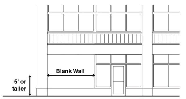
Block. Defined in .
Blockface. Defined in .
Blue Roof. A roof designed to store water and discharge rainfall.
Buffer. An area of dimensional separation between land uses, buildings, or structures, which is undeveloped, with installed screening and/or undisturbed and left in a natural condition.
Buffer Yard. An area of land within a property or site, generally adjacent to and parallel with a property line, to allow adequate screening of view, noise, and/or activity taking place within the property or site from adversely affecting an adjoining property, site, or the public right-of-way.
Build-To Line (BTL). Defined in .
Build-To Zone (BTZ). Defined in .
Build-To Percentage. Defined in .
Buildable Area. The portion of a lot, excluding required setbacks, where a structure or building improvements may be erected.
Building. Any structure having a roof supported by columns or walls and intended for the shelter, housing, or enclosure of any individual, animal, process, equipment, goods, or materials of any kind and intended for use in one place.
Building Coverage. Defined in .
Building Envelope. The three-dimensional space within which a structure is permitted to be built on a lot and which is defined by regulations governing building setbacks, maximum height, and bulk, by other regulations, and/or by any combination thereof.
Building Footprint. The area encompassed by a building's outer wall at ground level.
Building Height. Defined in .
Building Line. A line measured at the building wall of a structure between parallel lot lines. For the purposes of establishing a building line, the building wall does not include permitted encroachments of architectural features, such as bay windows, eaves, and steps and stoops.
BUILDING LINE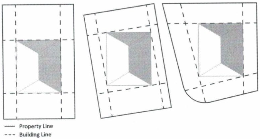
BUILDING LINE (3-D VIEW)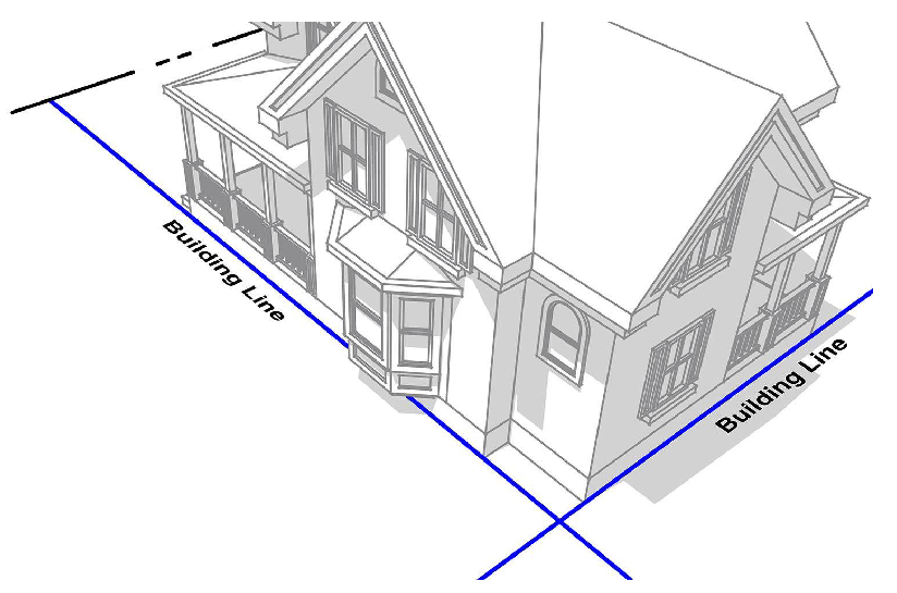
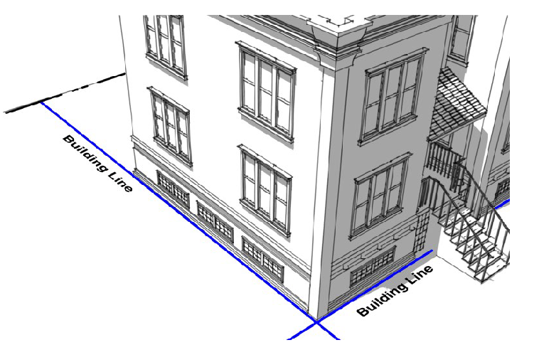
Building Permit. A permit issued by the duly designated building official authorizing the erection, construction, reconstruction, alteration, repair, conversion, or maintenance of a building, structure, or portion thereof.
Canopy. A canopy is a roof-like cover designed for protection from the weather or as a decorative embellishment affixed to a building or freestanding, with supports that extend to the ground.
Carport. A roofed structure intended to provide a sheltered parking space for the parking of motor vehicles and enclosed on not more than three sides.
Chicken Coop. A structure where hens are kept.
Chimney. A vertical shaft of reinforced concrete, masonry or other approved material enclosing one or more flues, for the purpose of removing products of combustion from solid, liquid, or gaseous fuel.
Coldframe Structure. A temporary unheated outdoor structure consisting of a frame and a top of glass or clear plastic, used for protecting seedlings and plants from the cold.
Co-Location. Placement of equipment from more than one service or service provider on a single tower or site.
Cross-Access. A vehicular and/or pedestrian connection between abutting properties that connects the two sites and allows vehicles and/or pedestrians to travel between sites without the having to exit to the street.
CROSS-ACCESS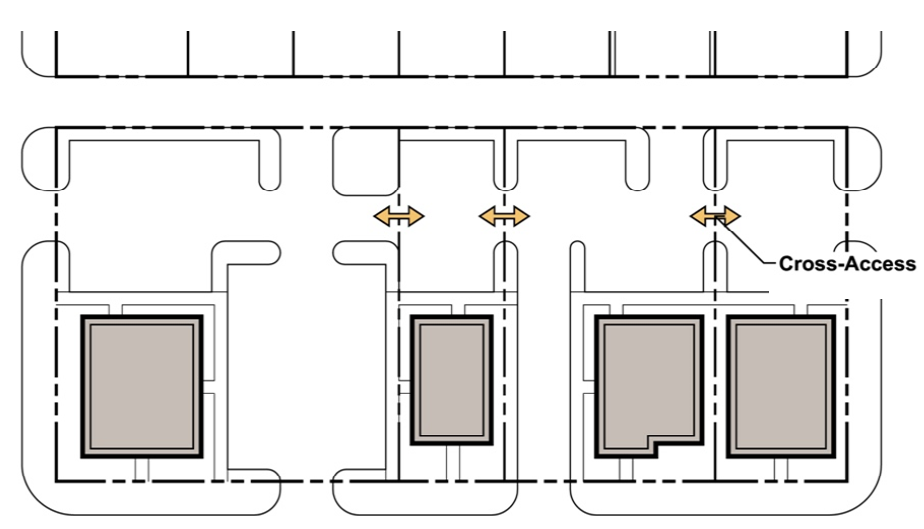
Deck, First Floor. A roofless outdoor space built as an aboveground platform projecting from the first floor of a structure and connected by structural supports at grade and/or by the structure.
Deck, Upper Story. A roofless outdoor space built as an aboveground platform projecting from and connecting to an upper story wall of a structure with structural supports that extend to the ground.
Donation Box. An unmanned receptacle designed with a door, slot, or similar opening intended to accept and store donated clothes and household items.
Driveway. A private roadway providing access to a street or highway.
Dwelling. A structure, or portion thereof, designed exclusively for human habitation.
Dwelling Unit. One or more habitable rooms which are occupied, or which are intended or designed to be occupied as a residence by one "family", with facilities for living, sleeping, sanitation, and cooking. "Family" means for purposes of :
(1)
An individual; or .....
(2)
Two or more persons related by blood, marriage or law; or .....
(3)
A group of two or more unrelated persons living together in a dwelling unit, not to exceed four persons in a dwelling unit with three or fewer bedrooms, and not to exceed five persons in a dwelling unit with four or more bedrooms. Such group may include a combination of related and unrelated persons. .....
Easement. A grant of one or more of the property rights by the property owner to and/or for use by the public, a corporation, or another person or entity.
Eave. The projecting lower edges of a roof overhanging the wall of a structure.
Egress. A place or means of exiting a property.
Elevated Building. A non-basement building built to have the lowest floor of the lowest enclosed area elevated above the ground level by means of solid foundation perimeter walls with openings sufficient to facilitate the unimpeded movement of floodwater, pilings, columns, piers, or shear walls adequately anchored so as not to impair the structural integrity of the building during a base flood event.
Emergency Flood Insurance Program. A program as implemented on an emergency basis in accordance with Section 1336 of the Act. It is intended as a program to provide a first layer amount of insurance on all insurable structures before the effective date of the initial FIRM. Also called Emergency Program.
Encroachment. The extension or placement of any structure, or a component of such, into a required setback or right-of-way.
Enlargement. An increase in the size of an existing structure or use, including the physical size of the property, building, parking, and other improvements.
Endwall. The wall of the end unit of a townhouse development that is not attached to another dwelling unit or party wall.
Entablature. An architectural feature that consists of a horizontal, continuous band of elements supported by and situated above the columns of a building or structure.
Erect. To build, construct, attach, hang, place, suspend, or affix.
Erosion. The process of the gradual wearing away of land masses. This peril is not "per se" covered under the Program.
Exception (in Special Flood Hazard Areas). A waiver from the provisions of the Special Flood Hazard Area section of this Ordinance which relieves the applicant from the requirements of a rule, regulation, order or other determination made or issued pursuant to this Ordinance.
Existing Construction (Floodplain). Any structure for which the "start of construction" commenced before the effective date of the initial floodplain management code or ordinance adopted by the community as a basis for that community's participation in the NFIP.
Existing Use. The use of a property at the time that an application for development or redevelopment is made.
Expansion to an Existing Manufactured Home Park or Subdivision. The preparation of additional sites by the construction of facilities for servicing the lots on which the manufactured homes are to be affixed (including the installation of utilities, the construction of streets, and either final site grading or the pouring of concrete pads).
External Illumination. Illumination by an artificial source of light not internal to the sign face.
Exterior Lighting. The illumination of an outside area or object by any man-made device that produces light by any means.
Exterior Wall. Any wall that defines the exterior boundaries of a building or structure.
Exterior Stairwell. One or more flights of stairs, and the necessary landings and platforms connecting them, to form a continuous passage from the entryway of a floor or level to another in a structure located on the exterior of a principal building.
Facade. An exterior building wall, from grade to the top of the parapet or eaves. A facade incorporates the full width of a building elevation, including any projections or recesses occurring across an elevation. The front facade is the principal elevation of a building and contains the building's main entrance, the rear facade is the building's rear exterior wall, and the side facades are a building's side exterior walls.
FEMA. Federal Emergency Management Agency.
Fence. An artificially constructed barrier of any permitted material or combination of materials erected to enclose, screen, or separate areas.
(1)
Fence—Open. A fence that has, over its entirety, more than 70% of the superficial surface consisting of regularly distributed openings. .....
(2)
Fence—Solid. A fence that has, over its entirety, no distributed openings. A shadowbox design fence is considered a solid fence. A chain link fence with slats is not considered a solid fence. .....
Fenestration. Windows and other openings on a building facade.
Fill. Any material including but not limited to soil, gravel, sand, rock or similar materials that is placed, deposited, or graded by human activity to raise the ground surface to a desired elevation or grade.
Finished Elevation. The proposed elevation of the land surface of a site after completion of all site preparation work.
First Floor Demarcation Line. The boundary that marks the separation between the first floor (of a building and the floors above it.
Flood or Flooding. A general and temporary condition of partial or complete inundation of normally dry land areas from:
(1)
The overflow of inland waters. .....
(2)
The unusual and rapid accumulation or runoff of surface waters from any source. .....
Flood Elevation Determination. A determination by the Federal Emergency Management Agency (FEMA) of the water surface elevations of the base flood, that is, the flood level that has a one percent or greater chance of occurrence in any given year.
Flood Elevation Study. An examination, evaluation and determination of flood hazards and, if appropriate, corresponding water surface elevations, or an examination, evaluation and determination of mudslide (i.e., mudflow) or flood-related erosion hazards.
Flood Fringe. The portion of the one-percent annual chance floodplain located outside of the floodway.
Flood Hazard Boundary Map (FHBM). An official map of a community on which the Federal Insurance Administration has delineated both the areas of special flood hazard and the risk premium zones applicable to the community.
Flood Hazard Zone. The Flood Hazard Zone includes all areas covered by the Floodway Zone plus all areas of special flood hazard as set forth and identified as such by the Federal Emergency Management Agency in its most recent Floodway Maps and Flood Insurance Rate Maps (FIRM) for the community and all property which is considered to be below the elevation of the "High Water Stage" for the Tennessee River and its tributaries. Changes and additions to the Flood Hazard Zone by Tennessee Valley Authority study are hereby adopted and add to or change the Flood Hazard Zone.
Flood Insurance Rate Map (FIRM). An official map of a community, on which the Federal Emergency Management Agency had delineated both the areas of special flood hazard and the risk premium zones applicable to the community.
Flood Insurance Study. The official report provided by the Federal Emergency Management Agency. The report contains flood profiles, as well as the flood Boundary Floodway Map and the water surface elevation of the base flood.
Floodplain. Any land area susceptible to being inundated by water from any source (see definition of "flooding"). Also called Floodprone Area.
Floodplain Management. The operation of an overall program of corrective and preventive measures for reducing flood damage, including but not limited to emergency preparedness plans, flood control works and floodplain management regulations.
Floodplain Storage. The volume or quantity of stormwater surface runoff temporarily or permanently held within the boundaries of the regulatory floodplain. Net increase of floodplain storage as a result of fill refers to the additional volume or quantity of stormwater surface runoff temporarily or permanently held within the boundaries of the regulatory floodplain that exists as a direct result of the fill materials added to the floodplain that would have otherwise not existed.
Floodproofing. Any combination of structural and nonstructural additions, changes, or adjustments to structures which reduce or eliminate flood damage to real estate or improved real property, water and sanitary facilities, structures, and their contents.
Flood Protection System. Those physical structural works for which funds have been authorized, appropriated, and expended and which have been constructed specifically to modify flooding in order to reduce the extent of the area within a community subject to a "special flood hazard" and the extent of the depths of associated flooding. Such a system typically includes hurricane tidal barriers, dams, reservoirs, levees or dikes. These specialized flood modifying works are those constructed in conformance with sound engineering standards.
Flood-related Erosion. The collapse or subsidence of land along the shore of a lake or other body of water as a result of undermining caused by waves or currents of water exceeding anticipated cyclical levels or suddenly caused by an unusually high water level in a natural body of water, accompanied by a severe storm, or by an unanticipated force of nature, such as a flash flood, or by some similarly unusual and unforeseeable event which results in flooding.
Flood-related Erosion Area or Flood-related Erosion Prone Area. A land area adjoining the shore of a lake or other body of water, which due to the composition of the shoreline or bank and high water levels or wind-driven currents, is likely to suffer flood-related erosion damage.
Flood-related Erosion Area Management. The operation of an overall program of corrective and preventive measures for reducing flood-related erosion damage, including but not limited to emergency preparedness plans, flood-related erosion control works and floodplain management regulations.
Floodway. The channel of a river or other watercourse and the adjacent land areas that must be reserved in order to discharge the base flood without increasing the water surface elevation at the High Water State or the Base Flood. The Floodway Zone of Ninemile Branch, Black Creek, Ryall Springs Branch, Mackey Branch and Friar Branch is identified by the Federal Emergency Management Agency and shown on its Flood Boundary and Floodway Maps dated September 6, 1989. The Floodway Zone for other streams is identified by lines and the notation 'F/W' on the official Zoning Maps. Changes and additions to the Floodway Zone by Tennessee Valley Authority study are hereby adopted and add to or change the Floodway Zone.
Flood Protection System. Those physical structural works for which funds have been authorized, appropriated, and expended and which have been constructed specifically to modify flooding in order to reduce the extent of the area within a community subject to a "special flood hazard" and the extent of the depths of associated flooding. Such a system typically includes hurricane tidal barriers, dams, reservoirs, levees or dikes. These specialized flood modifying works are those constructed in conformance with sound engineering standards.
Foot-Candle. A unit of measure of illuminance equal to one lumen of light spread over an area of one square foot.
Freeboard. A factor of safety usually expressed in feet above a flood level for purposes of floodplain management. "Freeboard" tends to compensate for the many unknown factors that could contribute to flood heights greater than the height calculated for a selected size flood and floodway conditions, such as wave action, blockage of bridge or culvert openings, and the hydrological effect of urbanization of the watershed.
Frontage. The boundary line of a lot between a building and the right-of-way or the pavement of a sidewalk.
Functionally Dependent Use. A use which cannot perform its intended purpose unless it is located or carried out in close proximity to water. The term includes only docking facilities, port facilities that are necessary for the loading and unloading of cargo or passengers, and ship building and ship repair facilities, but does not include long-term storage or related manufacturing facilities.
Garage. An accessory building or portion of a principal building used for the storage of motor vehicles of the occupants of the premises.
Gazebo. A freestanding outdoor accessory structure designed for recreational use and not for habitation.
General Floodplain. Those floodplains designated on the Flood Insurance Rate Maps referenced in , that are not VE or V zones, and that do not have a delineated floodway.
Glare. The effect produced by light from a luminaire with an intensity sufficient to cause annoyance, discomfort, or loss in visual performance and visibility.
Grading. Any stripping, cutting, filling, or stockpiling of earth or land, including the land in its cut or filled condition, to create new grades for development of the lot.
Green Roof. A building roof partially or completely covered with vegetation and a growing medium, planted over a waterproofing membrane. It may also include additional layers such as a root barrier and drainage and irrigation systems.
Gross Floor Area (GFA). Defined in .
Habitable Floor. Any floor usable for living purposes, which includes working, sleeping, eating, cooking or recreation, or a combination thereof. A floor used only for storage purposes is not a Habitable Floor. This definition replaces the definition of Lowest Habitable Floor.
Hardscape. Nonliving components of a landscape design, such as walls, sculpture, paved walkways, patios, stone and gravel areas, benches, fountains, and similar hard-surface areas and objects.
Hedge. A row of bushes or small trees planted close together, especially when demarcating a boundary or forming a barrier.
High Water Stage. The High Water Stage for the Tennessee River (Nickajack Lake) and its tributaries are that elevation determined by the Federal Emergency Management Agency as the one hundred (100) year flood elevation as shown on the flood profiles in its Flood Insurance Study for the City of Chattanooga, Tennessee, dated September 6, 1989, and any other applicable profiles as completed by the Tennessee Valley Authority.
High Water Stage. The 100-year Floodplain Elevation.
Highest Adjacent Grade. The highest natural elevation of the ground surface, prior to construction, adjacent to the proposed walls of a structure.
Historic Structure. Any structure that is:
1.
Listed individually in the National Register of Historic Places (a listing maintained by the U.S. Department of Interior) or preliminarily determined by the Secretary of the Interior as meeting the requirements for individual listing on the National Register; .....
2.
Certified or preliminarily determined by the Secretary of the Interior as contributing to the historical significance of a registered historic district or a district preliminarily determined by the Secretary to qualify as a registered historic district; .....
3.
Individually listed on the Tennessee inventory of historic places and determined as eligible by states with historic preservation programs which have been approved by the Secretary of the Interior; or .....
4.
Individually listed on the City of Chattanooga, Tennessee inventory of historic places and determined as eligible by communities with historic preservation programs that have been certified either: .....
a.
By the approved Tennessee program as determined by the Secretary of the Interior or .....
b.
Directly by the Secretary of the Interior. .....
Impervious Surface Coverage. Defined in .
Incidental. Subordinate and minor in significance and bearing a reasonable relationship to the primary use.
Infrastructure. Facilities and services needed to sustain land use activities.
Ingress. A place or means of gaining access or entry into a property.
Intensity of Use. Square feet of gross floor area, number of dwelling units, number of employees, or other factor used as a basis for requiring off-street parking or loading facilities.
Letter of Map Change (LOMC). An official FEMA determination, by letter, that amends or revises an effective Flood Insurance Rate Map or Flood Insurance Study. Letters of Map Change include:
Letter of Map Amendment (LOMA). An amendment based on technical data showing that a property was incorrectly included in a designated special flood hazard area. A LOMA amends the current effective Flood Insurance Rate Map and establishes that a specific property or structure is not located in a special flood hazard area.
Conditional Letter of Map Revision Based on Fill (CLOMR-F). A determination that a parcel of land or proposed structure that will be elevated by fill would not be inundated by the base flood if fill is placed on the parcel as proposed or the structure is built as proposed.
Letter of Map Revision Based on Fill (LOMR-F). A determination that a structure or parcel of land has been elevated by fill above the base flood elevation and is, therefore, no longer exposed to flooding associated with the base flood. In order to qualify for this determination, the fill must have been permitted and placed in accordance with the community's floodplain management regulations.
Conditional Letter of Map Revision (CLOMR). A formal review and comment as to whether a proposed flood protection project or other project complies with the minimum NFIP requirements for such projects with respect to delineation of special flood hazard areas. A CLOMR does not revise the effective Flood Insurance Rate Map or Flood Insurance Study; upon submission and approval of certified as-built documentation, a Letter of Map Revision may be issued by FEMA, to revise the effective FIRM.
Letter of Map Revision (LOMR). Letter of Map Revisions are generally based on the implementation of physical measures that affect the hydrologic or hydraulic characteristics of a flooding source and thus result in the modification of the existing regulatory floodway, the effective Base Flood Elevations (BFEs), or the Special Flood Hazard Area (SFHA). The LOMR officially revises the Flood Insurance Rate Map (FIRM) or Flood Boundary and Floodway Map (FBFM), and sometimes the Flood Insurance Study (FIS) report, and when appropriate, includes a description of the modifications. The LOMR is generally accompanied by an annotated copy of the affected portions of the FIRM, FBFM, or FIS report.
Levee. A man-made structure, usually an earthen embankment, designed and constructed in accordance with sound engineering practices to contain, control or divert the flow of water so as to provide protection from temporary flooding.
Levee System. A flood protection system which consists of a levee, or levees, and associated structures, such as closure and drainage devices, which are constructed and operated in accordance with sound engineering practices.
Light Pole. Pole on which a luminaire is mounted.
Light Trespass. The shining of light produced by a luminaire (light fixture) beyond the boundaries of the property on which it is located.
Lighting, Full Cutoff. A light distribution where the candela value is zero at or above horizontal (90º above nadir) and does not exceed 10% at or above a vertical angle of 80º above nadir.
FULL CUTOFF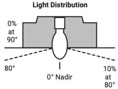
Lot. Defined in .
Lot Area. Defined in ..
Lot, Corner. Defined in .
Lot Depth. Defined in .
Lot, Interior. Defined in .
Lot of Record. A lot that exists as shown or described on a plat or deed in the records of the local registry of deeds.
Lot Line. Defined in .
Lot Line, Corner. Defined in .
Lot Line, Front. Defined in .
Lot Line, Interior. Defined in .
Lot Line, Rear. Defined in .
Lot Line, Street. Defined in .
Lot, Through. Defined in .
Lot Width. Defined in .
Lowest Floor. For purposes of adopted flood regulations, means the lowest floor of the lowest enclosed area, including a basement. An unfinished or flood resistant enclosure used solely for parking of vehicles, building access or storage in an area other than a basement area is not considered a building's lowest floor, provided, that such enclosure is not built so as to render the structure in violation of the applicable non-elevation design requirements of applicable flood regulations.
Lumen. A unit of measure of the quantity of light that falls on an area of one square foot, every point of which is one foot from the source of one candela.
Luminaire. A complete lighting unit consisting of a light source, pole, and all mounting brackets, if appropriate, and all necessary mechanical, electrical, and decorative parts.
Manufactured Home Stand. The area of a manufactured home site that has been reserved for the placement of a manufactured home.
Mean Sea Level. The average height of the sea for all stages of the tide.
Mitigation/Mitigate. Methods used to alleviate or lessen the impact of development.
Mixed-Use. A building that contains both non-residential and residential uses.
Mixed-Use Development. The development of a building or tract of land with a variety of complementary and integrated uses permitted in the zone, such as, but not limited to, residential, office, commercial, industrial, public, and recreation, in a compact urban form.
National Geodetic Vertical Datum (NGVD). As corrected in 1929, a vertical control used as a reference for establishing varying elevations within the floodplain.
New Construction. For purposes of adopted flood regulations, means any structure for which the "start of construction" commenced on or after the effective date of the initial floodplain management regulations, and includes any subsequent improvements to such a structure.
New Manufactured Home Park or Subdivision. A manufactured home park or subdivision for which the construction of facilities for servicing the lots on which the manufactured homes are to be affixed (including at a minimum, the installation of utilities, the construction of streets, and either final site grading or the pouring of concrete pads) is completed on or after the effective date of this ordinance or the effective date of the initial floodplain management ordinance and includes any subsequent improvements to such structure.
Nonresidential Zones. Zones that allow a variety of nonresidential uses such as retail, restaurant, service, and office, where such types of uses are the primary uses allowed, or where a wide range of commercial uses are allowed with residential uses to create mixed-use development.
Nonresidential Use. A structure or land used or intended to be used for nonresidential uses, which includes, but is not limited to, retail, office, entertainment, recreation, public, institutional, and other nonresidential uses. Structures with multi-unit dwellings above ground floor nonresidential uses are considered mixed-use development and considered a nonresidential use for the purposes of this Code.
North American Vertical Datum (NAVD). As corrected in 1988, a vertical control used as a reference for establishing varying elevations within the floodplain.
Off-Street Parking. A space intended for the storage of a motor vehicle on premises other than streets or rights-of-way.
Outlot. An area of land set aside within a retail center for a separate principal building that shares a circulation system and may share common parking with the larger retail center development but is separated from the principal building or buildings, typically located along the property line.
Owner. An individual, firm, association, syndicate, partnership, or corporation having sufficient proprietary interest to seek development of land, such as the owner of the title or a mortgage whose interest is shown of record in the mortgage and conveyance records, a person shown as owner in the records of the tax assessor of the county in which the property is situated, or the agent of any such person and those in possession of a dwelling, dwelling unit, or premises.
Parapet. The extension of a false front or wall above a roofline.
Parking Facility. A parking lot and/or parking structure. Parking facility does not include parking spaces and parking pads for individual dwelling units for single-unit, two-unit, or townhouse dwellings.
Parking Lot. An open, hard-surfaced area, excluding a street or public way, used for the storage of operable vehicles, whether for compensation or at no charge.
Parking Structure. A structure used for the parking or storage of operable vehicles, whether for compensation or at no charge.
Party Wall. A common wall from the foundation and extending continuously through all stories to or above the roof that separates one building from another, but in joint use by each building.
Patio. A hard surface designed and intended for recreational use by people and not used as a parking space.
Pedestrian Access. An entrance providing both ingress and egress, operable to residents at all times and customers during regular business hours, is required to meet the street-facing entrance requirements. Additional entrances off another street, pedestrian area or internal parking area are allowed. The entrance spacing requirements must be met for each building but are not applicable to adjacent or abutting buildings. Entrance spacing is measured from the edge of door to the edge of the next door. An angled entrance may be provided at either corner of a building along the street to meet the street-facing entrance requirements.
Pedestrian Facilities. Sidewalks, shared use paths, and similar facilities intended for pedestrian mobility.
Pergola. An open structure, which may be either freestanding or attached to a structure, that forms a partially shaded pedestrian walkway, passageway, or sitting area, and is constructed of a semi-open roof and vertical posts that support cross-beams and a sturdy open lattice. It may also be used as an extension of a building entryway.
Person. Any individual or group of individuals, corporation, partnership, association, or any other entity, including State and local governments and agencies.
Pervious Paving. A range of sustainable materials and techniques for permeable paving that allow the movement of water through the surface. Gravel and loose rock are not considered pervious paving.
Porch. An architectural feature that projects from the exterior wall of a structure, has direct access to the street level of the building, and is covered by a roof or eaves.
(1)
Porch—Unenclosed. A porch that is open on all sides, with the exception of the side attached to the principal building. .....
(2)
Porch—Enclosed. A porch enclosed by walls, screens, lattice or other material. A screened-in porch is an enclosed porch. .....
Porte Cochere. A permanent structure built over a driveway or entry drive that provides temporary shelter to persons exiting a vehicle, but not serving as the only covered or enclosed vehicle shelter on-site.
Principal Building. A non-accessory structure in which a principal use of the lot on which it is located is conducted.
Principal Building Line. See "building line."
Principal Use. The main use of land or structures as distinguished from an accessory use.
Prominent Entrance. A building entrance that is visually distinctive from the remaining portions of the facade where it is located and is parallel and directly connected to adjacent pedestrian facilities. Entrances that contain at least three of the following are considered a prominent entrance: decorative pedestrian lighting/sconces; architectural details carried through to upper stories; covered porches, canopies, awnings, or sunshades; archways; transom or sidelight windows; terraced or raised planters; common outdoor seating enhanced with specialty details, paving, landscaping, or water features; double doors; stoops or stairs.
Protected Zone: As relates to the Downtown Form-based Code, includes the following zones: A-1, RN-1-3, RN-1-5, RN-1-6, RN-1-7.5, RN-2 and RD.
Reach. A hydraulic engineering term to describe a longitudinal segment of a stream or river influenced by a natural or man-made obstruction. In an urban area, the segment of a stream or river between two consecutive bridge crossings would most typically constitute a reach.
Reasonably Safe from Flooding. Base flood waters will not inundate the land or damage structures to be removed from the Special Flood Hazard Area and that any subsurface waters related to the base flood will not damage existing or proposed structures.
Regulatory Flood Protection Elevation (RFPE). An elevation that is one foot above the elevation of the base flood plus any increases in the water surface elevation caused by encroachments on the floodplain that result from designation of a floodway. These increases in water surface elevations are typically identified in the Floodway Data Tables, found in the Flood Insurance Study.
Repetitive Loss. For purposes of adopted flood regulations, means flood-related damage sustained by a structure on two separate occasions during a ten year period for which the cost of repairs at the time of each such flood event, on the average, equals or exceeds 25% of the market value of the structure before the damage occurred.
Recreational Vehicle. Any vehicle or boat designed for recreational purposes and temporary living quarters while camping and/or travelling and not used as a commercial vehicle including, but not limited to, boat/watercraft, camper trailer, motorized trailer, off-road vehicle, racing car or cycle, travel trailer, and truck camper.
Refuse Container. An exterior waste container designed to be mechanically lifted by and emptied into or carted away by a collection vehicle.
Recycling Containers. A container for the collection of recyclables.
Regulatory Floodway. The channel of a river or other watercourse and the adjacent land areas that must be reserved in order to discharge the base flood without cumulatively increasing the water surface elevation more than a designated height.
Residential Zones. Zones where the primary permitted use is residential. Residential zones, within the use structure, may allow very limited compatible nonresidential uses, such as places of worship.
Residential Use. A structure designed and used or intended to be used for residential occupancy by one or more households, such as single-unit, two-unit, townhouse, and multi-unit dwellings. Multi-unit dwellings with ground floor nonresidential uses are considered mixed-use development, and are considered a nonresidential use for the purposes of this Code.
Right-of-Way. A strip of land dedicated for use as a public way. In addition to the roadway, it typically incorporates the curbs, tree lawn, sidewalks, and shoulders.
Riverine. Relating to, formed by, or resembling a river (including tributaries), stream, brook, etc.
Roofline. The top edge of a roof or building parapet, whichever is higher, excluding any cupolas, pylons, chimneys or minor projections.
Satellite Dish Antenna. A dish antenna designed for transmitting signals to a receiver or receiving station or for receiving television, radio, data, communication or other signals from other antennas, satellites or other services.
Setback. Defined in .
Setback, Corner Side. Defined in .
Setback, Front. Defined in .
Setback, Interior Side. Defined in .
Setback, Parking. Defined in .
Setback, Rear. Defined in .
Setback, Street. Defined in .
Shed. An accessory structure, often purchased pre-built or as a kit in pre-fabricated sections, that is not designed to be served by heat or plumbing and does not need to be placed on a permanent foundation. A shed is typically intended to store lawn, garden, or recreational equipment.
Short-Term Vacation Rental. See Article XVII.
Solar Panel. A photovoltaic device capable of collecting and converting solar energy into electricity.
Special Flood Hazard Area. The land in the floodplain within a community which is subject to a one percent or greater chance of flooding in any given year. The area may be designated as Zone A on the FHBM. After detailed ratemaking has been completed in preparation for publication of the FIRM, Zone A usually is refined into Zones A, AO, AH, A1-30, AE or A99.
Special Hazard Area. An area having special flood, mudslide (i.e., mudflow) and/or flood-related erosion hazards, and shown on an FHBM or FIRM as Zone A, AO, A1-30, AE, A99, or AH.
Stacking Space. A space specifically designed and designated as a waiting area for vehicles patronizing a drive-through facility or service bay.
Standpipe. A rigid vertical or horizontal pipe to which fire hoses can be connected, which may be building, ground, or roof mounted.
Start of Construction. The date the building permit was issued, provided the actual start of construction, repair, reconstruction, rehabilitation, addition, placement, or other improvement was within 180 days of the permit date. The actual start means either the first placement of permanent construction of a structure (including a manufactured home) on a site, such as the pouring of slabs or footings, the installation of piles, the construction of columns, or any work beyond the stage of excavation; and includes the placement of a manufactured home on a foundation. Permanent construction does not include initial land preparation, such as clearing, grading and filling; nor does it include the installation of streets and/or walkways; nor does it include excavation for a basement, footings, piers, or foundations or the erection of temporary forms; nor does it include the installation on the property of accessory buildings, such as garages or sheds, not occupied as dwelling units or not part of the main structure. For a substantial improvement, the actual start of construction means the first alteration of any wall, ceiling, floor, or other structural part of a building, whether or not that alteration affects the external dimensions of the building. Includes substantial improvements.
State Coordinating Agency. The Tennessee Emergency Management Agency, State NFIP Office, as designated by the Governor of the State of Tennessee at the request of FEMA to assist in the implementation of the NFIP for the State.
Stepback. In building height, a stepback is the required additional distance that upper stories of a structure must be recessed from the facade of the stories below.
Stoop. An exterior floor typically constructed of stone, concrete, and/or masonry, with a finished floor elevation higher than the adjacent ground level, often with steps leading up to it, and utilized primarily as an access platform to a structure. A stoop may be roofed and designed with railings, but cannot be enclosed.
Structural Alteration. Any change, other than incidental repairs, which would prolong the life of supporting members of a structure, such as the addition, removal, or alteration of bearing walls, columns, beams, girders, or foundations.
Structure. A combination of materials that form a construction for use, occupancy, or ornamentation, whether installed on, above, or below the surface of land or water.
Substantial Damage. For purposes of adopted flood regulations, means damage of any origin sustained by a structure whereby the cost of restoring the structure to its before-damaged condition would equal or exceed 50% of the market value of the structure before the damage occurred. Substantial damage also means flood-related damage sustained by a structure on two separate occasions during a ten year period for which the cost of repairs at the time of each flood event, on the average, equals or exceeds 25% of the market value of the structure before the damage occurred.
Substantial Improvement. For purposes of adopted flood regulations, for a building built prior to the enactment of floodplain regulations, any repair, reconstruction, or improvement of a building, the cost of which equals or exceeds 50% of the market value of the building either:
(1)
Before the improvement or repair is started; or .....
(2)
If the building has been damaged and is being restored before the damage occurred. .....
For the purposes of this definition, substantial improvement is considered to occur when the first alteration of any wall, ceiling, floor, or other structural part of the building commences, whether or not that alteration affects the external dimensions of the buildings. The term does not, however, include either:
(1)
Any project for improvement of a building to comply with existing state or local health, sanitary, or safety code specifications which are solely necessary to assure safe living conditions. .....
(2)
Any alteration of a building listed on the National Register of Historical Places or a State Inventory of Historic Places. .....
Substantially Improved Existing Manufactured Home Parks or Subdivisions. Is where the repair, reconstruction, rehabilitation or improvement of the streets, utilities and pads equals or exceeds 50% of the value of the streets, utilities and pads before the repair, reconstruction or improvement began.
Temporary Use. A use established for a limited duration with the intent to discontinue such use upon the expiration of the time period.
Transit-Oriented Development (TOD). The concentration of development nodes, consisting of mixed-use development located along designated public transit corridors and with convenient and easy access to public transit stations.
Transparency. The required amount of window area as a percentage of the specified facade area. Doors are included in ground floor transparency when such doors are designed with glass or other transparent materials. Garage entrances are not included in ground floor transparency.
(1)
To qualify as transparent for the calculation, glazing must have a minimum of 60% VLT and no more than 20% VLR. These glazing minimums do not apply to single-unit and two-unit dwellings. .....
(i)
The following do not meet the ground floor or upper floor transparency requirements and do not count in meeting the standard: .....
(ii)
Windows with shadowboxes on the interior .....
(iii)
Glass block .....
(iv)
Printed window film, regardless of whether it allows views into or out of the building. .....
(v)
Translucent glass at the ground story. .....
(2)
Visible Light Transmittance (VLT) and Visible Light Reflectance (VLR) are defined as: .....
(i)
Visible Light Reflectance (VLR): The amount of visible light that is reflected out by a glazing system. A high VLR percentage blocks more daylight from passing through the window. .....
(ii)
Visible Light Transmittance (VLT): The amount of light (daylight) that travels through a glazing system. A high VLT percentage allows more daylight to pass through. .....
(3)
Ground story fenestration is measured between two and 12 feet above the abutting sidewalk. .....
(4)
Upper story fenestration is measured from top of the finished floor to the top of the finished floor above. When there is not a floor above, upper story fenestration is measured from the top of the finished floor to the top of the wall plate above. .....
(5)
Transom windows, even if located less than 12 feet above the abutting sidewalk, are not required to meet the ground floor transparency requirement. .....
Unified Control. The combination of two or more tracts of land wherein each owner has agreed that his tract of land will be developed under the same development approvals.
Use. The purpose or activity for which the land or structure is designed, arranged, or intended, or for which it is occupied or maintained.
Vehicle, Inoperable. A vehicle is classified as inoperable when any of the following applies:
(1)
Lacks major or essential mechanical or body parts. .....
(2)
Is junked or partially disassembled. .....
(3)
Has been burned or flooded throughout. .....
(4)
Cannot be driven legally on public streets under State law or City ordinance. .....
(5)
Is otherwise incapable of moving under its own power. .....
(6)
Does not comply with State and City Codes with respect to license and registration. .....
(7)
Has one or more tires missing or not fully inflated. .....
(8)
Is economically impractical to restore to operating condition. .....
Vehicle, Junk. Any rusted, wrecked, damaged, dismantled, or partially dismantled, inoperative, or abandoned motor vehicle in such a condition that it is economically infeasible to restore the vehicle to an operating condition.
Violation. For purposes of adopted flood regulations, means the failure of a structure or other development to be fully compliant with the community's floodplain management regulations. A structure or other development without the elevation certificate, other certification, or other evidence of compliance required in the adopted flood regulations is presumed to be in violation until such time as that documentation is provided.
Watercourse. A channel in which a flow of water occurs either continuously or intermittently in a definitive direction. The term applies to either natural or artificially constructed channels.
Waterfront. Areas adjacent to bodies of water, such as rivers and lakes.
Water Surface Elevation. The height, in relation to the National Geodetic Vertical Datum (NGVD) of 1929, the North American Vertical Datum (NAVD) of 1988, or other datum, where specified, of floods of various magnitudes and frequencies in the floodplains of riverine areas.
White Roof. A roof designed to deliver high solar reflectance, reducing heat transfer to the building and the ability to radiate absorbed, or non-reflected solar energy.
Yard. Defined in .
Yard, Front. Defined in .
Yard, Interior Side. Defined in .
Yard, Corner Side. Defined in .
Yard, Rear. Defined in .
Zoning Lot. A lot or combination of lots within a single block, which is designated by its owner or developer to be used, developed, or built upon as a unit. A zoning lot may coincide with a lot of record or may be comprised of one or more lots of record.
(Ord. No. 14137, § 1, 7-23-24; Ord. No. 14138, § 1, 7-23-24; Ord. No. 14181, § 1, 12-17-24; Ord. No. 14330, § 1, 2-17-26; Ord. No. 14298, § 1, 12-2-25)
Sec. 38-10. - Rules of Measurement
This section provides the rules of measurement for the dimensional standards and locational characteristics within the Code.
(a)
Block and Blockface .....
(1)
A block is a tract of land bounded by streets, or a combination of streets and railroad rights-of-way or municipal boundary lines. .....
(2)
Blockface is measured as that portion of a block or tract of land facing the same side of a single street and lying between the closest intersecting streets. .....
BLOCK AND BLOCKFACE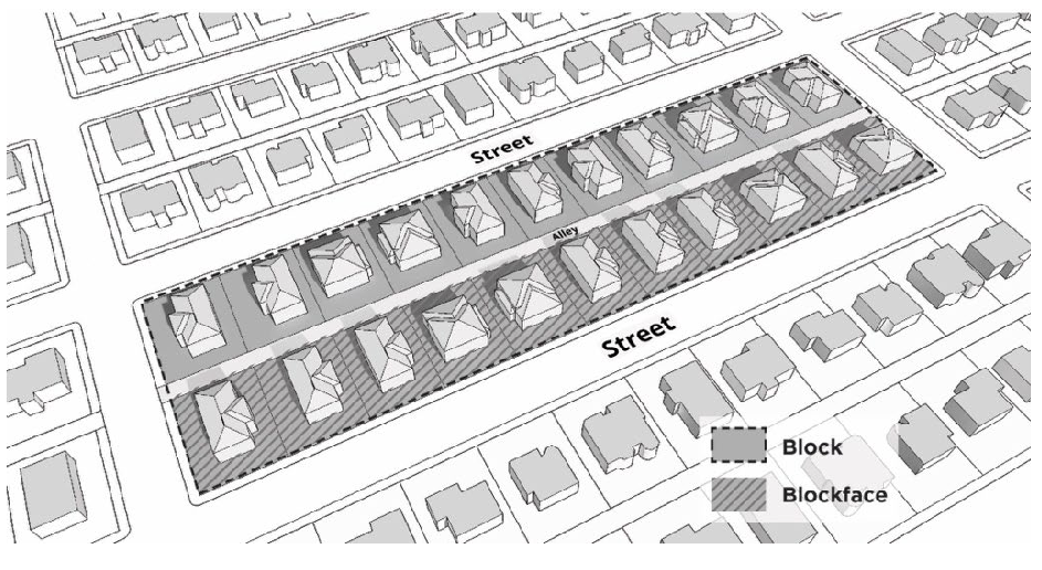
(b)
Build-To Dimensions .....
Certain dimensional requirements with the zones require structures to be constructed at a build-to dimension. A build-to requirement is a boundary or alignment, parallel to a lot line, where a structure must be placed. This Code includes the following build-to dimensions:
(1)
Build-To Zone (BTZ) .....
A build-to zone (BTZ) is the area on a lot, measured perpendicular from the applicable lot line, where the building must locate within the minimum and maximum range of setback provided. The building facade must be located within the build-to zone.
(2)
Build-Out Percentage (BO%) .....
A build-out percentage specifies the percentage of the total lot width that must be occupied by the building facade.
(3)
Build-To Percentage (BT%) .....
A build-to percentage specifies the percentage of the building facade that must be located within the build-to zone. Build-to percentage is calculated by building facade, not lot width.
(i)
Facade articulation elements, such as window or wall recesses and projections, are included in the calculation of a required build-to percentage. .....
(ii)
Programmed outdoor spaces and outdoor dining areas that are bounded by a building facade parallel to the frontage are included in the calculation of a required build-to percentage. .....
(iii)
Open space bounded on three sides by a building, such as courtyards, are included in the calculation of a required build-to percentage. .....
(iv)
On a corner lot, a building facade must be placed within the minimum and maximum setback range for the first 30 feet along the street extending from the block corner, measured from the intersection of the two right-of-way lines. .....
BUILD-TO ZONE (BTZ)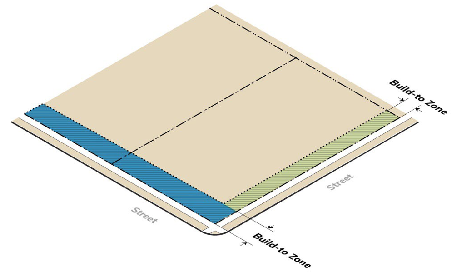
BUILD-OUT PERCENTAGE (BO%)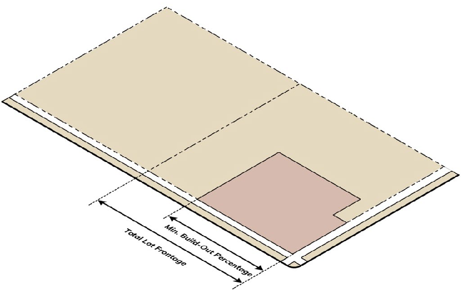
BUILD-TO PERCENTAGE (BT%)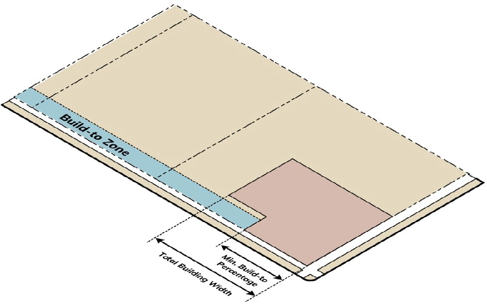
(c)
Building Coverage .....
Building coverage is the area of a lot covered by roofed buildings and structures measured from the outside of the exterior wall at the ground floor, including covered porches and patios, detached accessory structures, and any projecting structures above ground level.
(1)
For covered porches and patios, the entire area under the roof is calculated as building coverage. .....
(2)
Building coverage does not include: uncovered paved parking areas and driveways; uncovered walkways; roof overhangs; swimming pools; uncovered steps, terraces, and decks; and architectural projections. .....
(d)
Building Height .....
(1)
Maximum building height is measured from grade plane to: .....
(i)
The mean height between eaves and ridge for gable and hip roofs. .....
(ii)
The deckline for mansard roofs. .....
(iii)
The midpoint of the highest pitched section of a gambrel roof. .....
(iv)
The highest point of the roof for flat roofs with parapet walls of six feet in height or less. When parapet walls exceed six feet in height, the highest point of the parapet wall. .....
(2)
The following structures or parts thereof are exempt from maximum height limitations, unless otherwise limited by any height restriction imposed by any airport authority, or other similar federal, state, or local authority. .....
(i)
Public utility poles, towers, and wires. Public utilities do not include wireless telecommunications, solar panels, and wind turbines unless operated by a government agency. .....
(ii)
Water and wastewater tanks and standpipes. .....
(iii)
Building appurtenances such as chimneys, parapet walls, skylights, steeples, flag poles, smokestacks, cooling towers, elevator bulkheads, fire towers, monuments, water towers, stacks, stage towers, or scenery lofts, tanks, ornamental towers and spires, rooftop accessory structures, recreational facilities, necessary mechanical appurtenances, or penthouses to house mechanical appurtenances. .....
BUILDING HEIGHT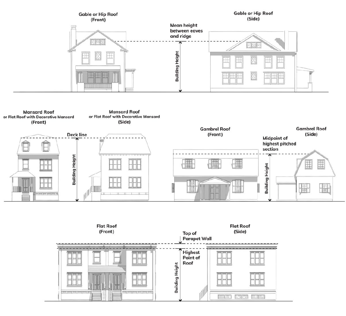
(e)
Grade Plane .....
(1)
A reference plane representing the average of finished ground level adjoining the building at exterior walls. .....
(2)
Where the finished ground level slopes away from exterior walls, the reference plane is established by the lowest points within the area between the building and the lot line or, when the lot line is more than six feet from the building, between the building and a point six feet from the building. .....
(f)
Gross Floor Area (GFA) .....
The gross floor area (GFA) of a structure is the sum of the gross horizontal areas of all floors of the structure as measured from the exterior faces of the exterior walls or from the centerline of walls separating two buildings.
(g)
Ground Floor Elevation .....
Ground floor elevation is measured from top of the adjacent curb, or from the crown of the road where no curb exists, to the top of the finished ground floor.
(h)
Lot .....
A lot is the basic development unit for determination of lot area, depth, and other dimensional regulations; or a parcel of land whose boundaries have been established by some legal instrument such as a recorded deed or recorded map and which is recognized as a separate legal entity for purposes of transfer of title. The following describes the types of lot configurations:
(1)
An interior lot is a lot other than a corner or double frontage lot, bounded by two interior side lot lines. .....
(2)
A corner lot is a lot situated at the junction of, and abutting on, two or more intersecting streets. .....
(3)
A double frontage lot is a lot which fronts upon two parallel streets, or which fronts upon two streets which do not intersect at the boundaries of the lot. A double frontage lot is also called a through lot. .....
(4)
A flag lot is platted so that the main building site area (the "flag") is set back from the street on which it fronts and includes an access strip (the "pole") connecting the main building site with the street. No new flag lots, with frontage less than the required minimum, are allowed in the City of Chattanooga. .....
LOT TYPES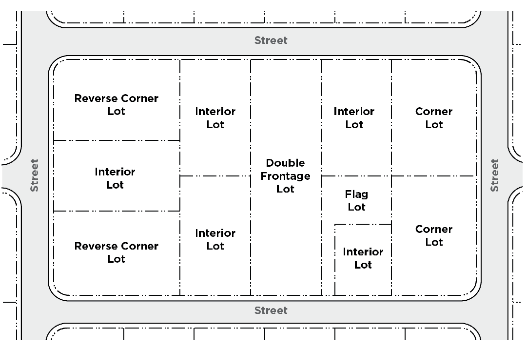
(i)
Lot Area .....
The total area within the boundaries of a lot, excluding any street right-of-way.
(j)
Lot Line .....
A line of record bounding a lot, as indicated on an approved, filed, and recorded subdivision plat, which divides one lot from another lot or from a public or private street or any other public or private space and includes:
(1)
A front lot line is the lot line separating a lot from a street right-of-way. The front lot line of a corner lot is the shortest street lot line of a corner lot abutting a street. A front lot line for a double frontage lot is both lot lines that abut a street. .....
(2)
A rear lot line is the lot line opposite and most distant from the front lot line. In the case of triangular or similarly irregularly shaped lots, the rear lot line is a calculated line of ten feet in length entirely within the lot, parallel to and at a maximum distance from the front lot line. .....
(3)
On a corner lot, the corner side lot line and reverse corner side lot line is perpendicular or approximately perpendicular to the front lot line and is the longer street abutting lot line of a corner lot. .....
(4)
On an interior lot, the interior side lot line is perpendicular or approximately perpendicular to the front lot line and abuts an adjacent lot. .....
(5)
A street lot line is any lot line separating a lot from a street right-of-way. .....
LOT LINES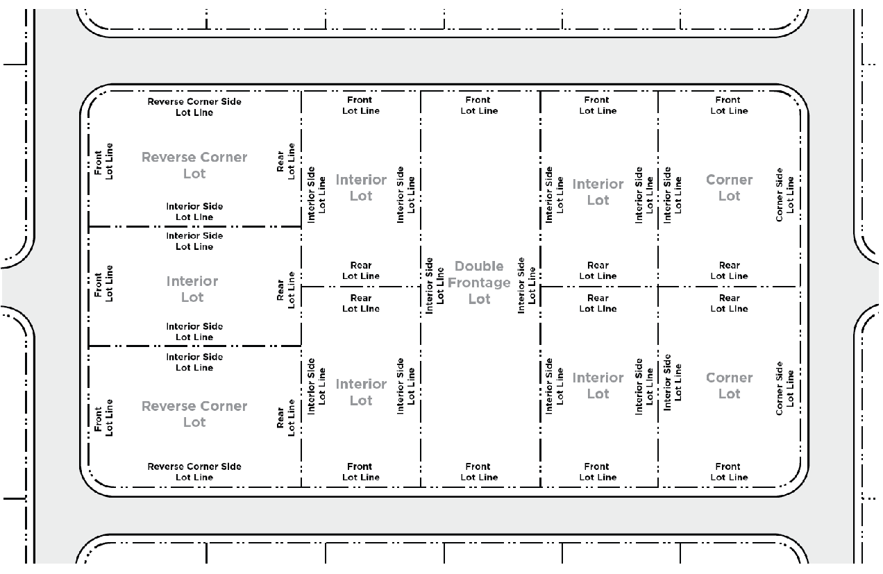
(k)
Lot Width .....
Lot width is measured at the required front setback of the zone. Where the front setback of the zone is a build-to zone (BTZ), the furthest dimension of the build-to zone is used to measure lot width.
(l)
Yards and Setbacks .....
(1)
General Definitions .....
(i)
A yard is the area between the building line of a principal building and the lot line. .....
(ii)
A required setback is the required minimum distance a principal building must be located from a lot line, which is unoccupied and unobstructed by any projections of a principal building, with the exception of permitted encroachments allowed by this Code. .....
a.
A build-to zone is considered a required setback. In the case of a build-to zone, the setback is the defined area (defined by minimum and maximum build-to lines) where the principal building must be located. .....
(iii)
A setback may be equal to or less than a yard. .....
(iv)
A setback is located along the applicable lot line for the minimum depth specified by the zone in which such lot is located. .....
(2)
Front Yard and Front Setback .....
The front yard and front setback extend the full width of the lot between side lot lines measured perpendicular to the front lot line.
(i)
Front Yard: A front yard is the area located between a principal building line and the front lot line. .....
(ii)
Front Setback: A front setback is the required minimum distance per the zone that a principal building must be located from the front lot line. .....
(iii)
For flag lots, the front yard and setback is measured from the rear lot line of the lot that separates the flag portion of the lot from the street. .....
(iv)
Front setback averaging is calculated by averaging the front setback of two adjacent lots on either side of the subject lot. In the case of a lot near or at the end of the block, the total number of lots averaged must equal four lots total along that blockface, beginning with the lot or lots adjacent. .....
(3)
Interior Side Yard and Interior Side Setback .....
The interior side yard and interior side setback extend along the interior side lot line between the front and rear yard or setback, measured perpendicular to the interior side lot line.
(i)
Interior Side Yard: An interior side yard is the area located between a principal building line and the interior side lot line. .....
(ii)
Interior Side Setback: An interior side setback is the required minimum distance per the zone that a principal building must be located from the interior side lot line. .....
(iii)
For single-unit attached dwellings, the interior side yard and interior side setback are only applicable to the side of the unit with no shared wall attachment to another unit. For townhouse developments, the interior side yard and interior side setback are only applicable to end units of the overall townhouse building. .....
(4)
Corner Side Yard and Corner Side Setback .....
The corner side yard and corner side setback extend along the corner side lot line between the front yard or front setback and the rear lot line, measured perpendicular to the corner side lot line.
(i)
Corner Side Yard: A corner side yard is the area located between a principal building line and the corner side lot line. .....
(ii)
Corner Side Setback: A corner side setback is the required minimum distance per the zone that a principal building must be located from the corner side lot line. .....
(5)
Reverse Corner Side Yard and Reverse Corner Side Setback .....
The reverse corner side yard and reverse corner side setback extend along the corner side lot line between the front yard or front setback and the rear lot line, measured perpendicular to the reverse corner side lot line.
(i)
Reverse Corner Side Yard: A reverse corner side yard is the area located between a principal building line and the corner side lot line. .....
(ii)
Reverse Corner Side Setback: A reverse corner side setback is the required minimum distance per the zone that a principal building must be located from the reverse corner side lot line. .....
(6)
Rear Yard and Rear Setback .....
The rear yard and rear setback extend between interior side lot lines, measured perpendicular to the rear lot line.
(i)
Rear Yard: A rear yard is the area located between a principal building line and the rear lot line. .....
(ii)
Rear Setback: A rear setback is the required minimum distance per the zone that a principal building must be located from the rear lot line. .....
(iii)
In the case of a corner lot, the rear yard and rear setback extend between the interior side lot line to the required corner side setback, measured perpendicular to the rear lot line. .....
(7)
Yard and Setback Requirements for Double-Frontage Lots .....
For double-frontage lots, both the front and the rear required setbacks must meet the required front setback of the zone. In the case of a double-frontage lot, one of the front setbacks are considered a rear yard for the purposes of applying the accessory structure regulations of this Code; the required dimension of the front setback still applies.
SETBACKS AND YARDS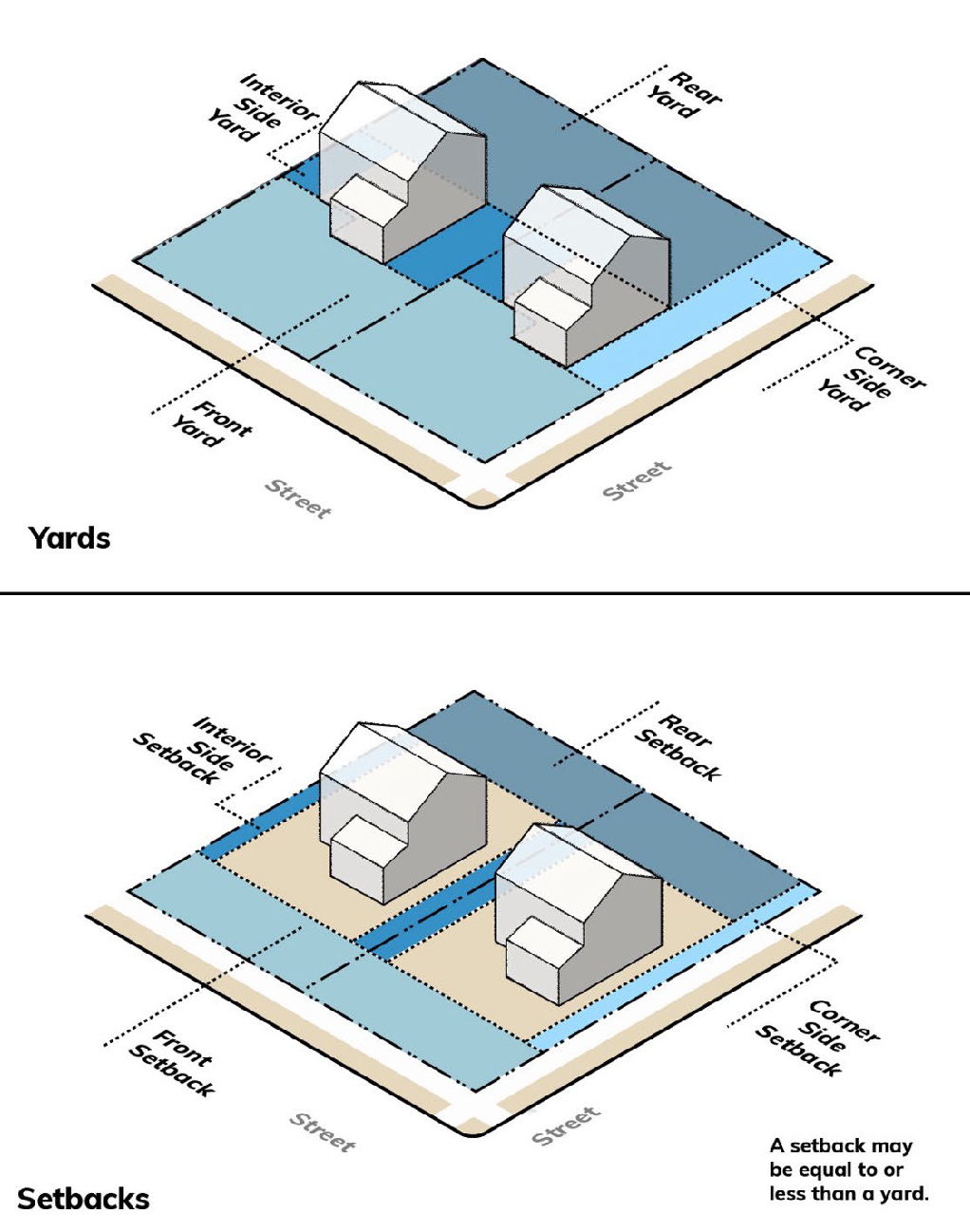
(8)
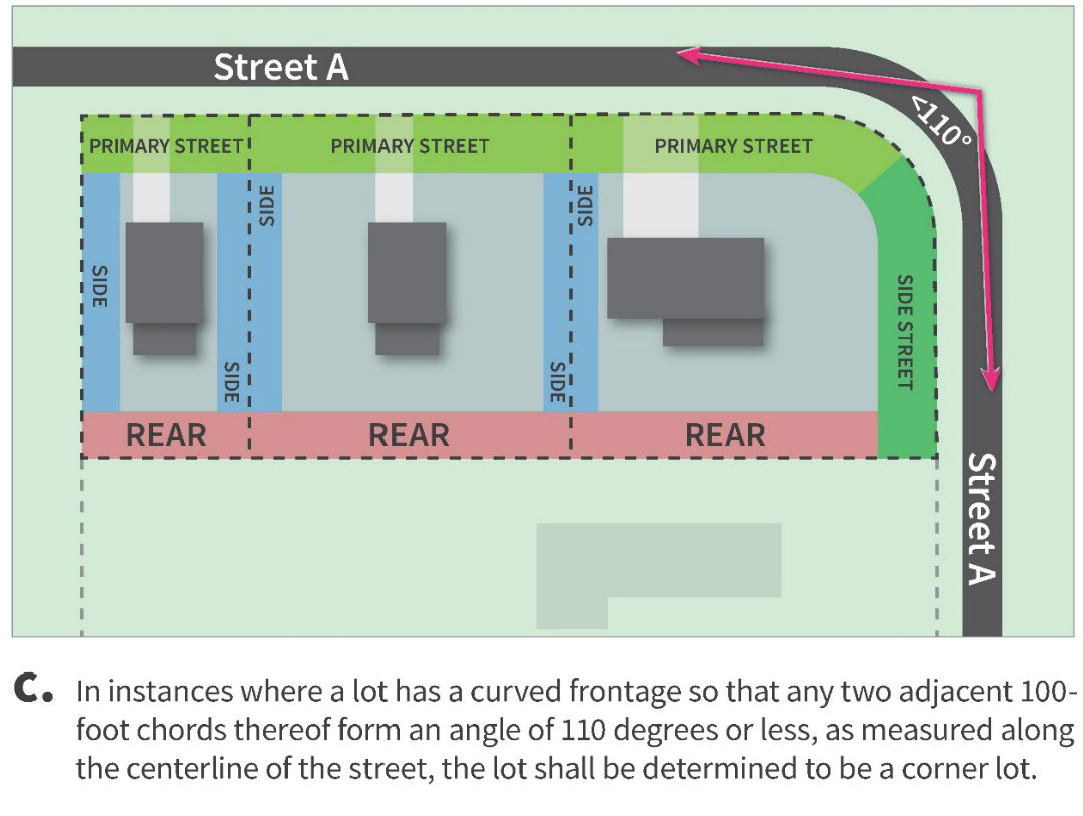
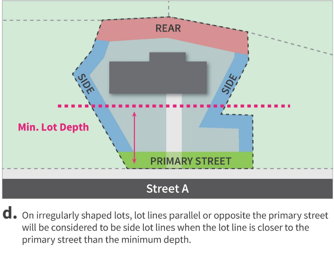
Setbacks for Irregular Shaped Lots. .....
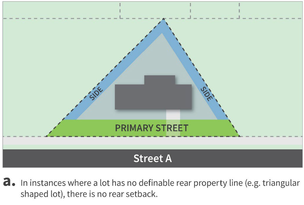
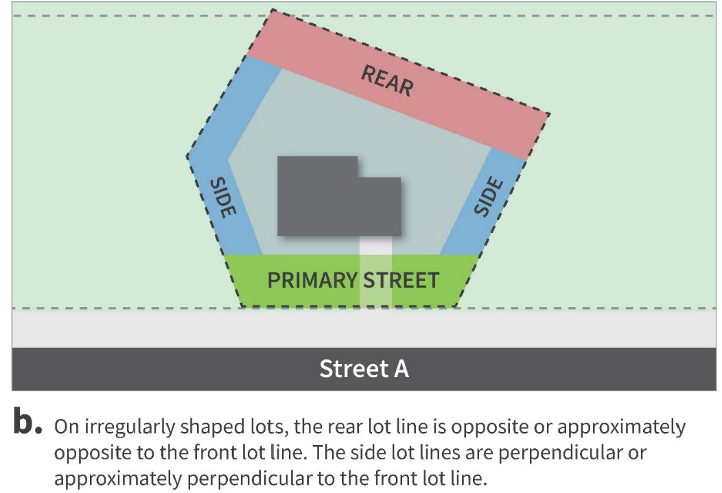
(Ord. No. 14137, § 1, 7-23-24; Ord. No. 14138, § 1, 7-23-24; Ord. No. 14320, § 1, 1-20-26)

