
Chattanooga City Zoning Code
ARTICLE VIII
SPECIAL PURPOSE ZONES
Sec. 38-28.- A-1 Urban Agricultural Zone
(a)
Purpose .....
The A-1 Urban Agricultural Zone is intended to provide the opportunity for agricultural land and related uses within the City.
(b)
Uses .....
Article IX lists principal, temporary, and accessory uses allowed in the A-1 Zone.
(c)
Dimensional Standards .....
(1)
Table 38-28.1: A-1 Zone Dimensional Standards establishes the dimensional standards for the A-1 Zone. These regulations apply to all uses within each zone unless a different standard is listed for a specific use. .....
(2)
All agricultural structures including, but not limited to, barns, feeding areas, livestock enclosures, and roofed livestock structures, are prohibited within required setbacks and must be located a minimum of 100 feet from any lot line. .....
(3)
Maximum building height does not apply to any structure ancillary to and integral to active agricultural operations, which are not limited in height. .....
(d)
Additional Standards .....
(1)
General Site Development Standards .....
See Article X for additional on-site development standards and requirements.
(2)
Accessory Structures .....
See Article XI for accessory structure standards and requirements.
(3)
Parking, Loading, and Access .....
See Article XII for parking, loading, and access standards and requirements.
(4)
Landscape .....
See Article XIII for landscape, buffer, and screening standards and requirements.
(Ord. No. 14137, § 1, 7-23-24; Ord. No. 14138, § 1, 7-23-24)
Sec. 38-29. - INST Institutional Zone
(a)
Purpose .....
The INST Institutional Zone is intended to accommodate governmental uses, larger public and private educational campuses, civic and cultural facilities, healthcare campuses, and similar uses located within the City.
(b)
Uses .....
Article IX lists principal, temporary, and accessory uses allowed in the INST Zone.
(c)
Dimensional Standards .....
Table 38-29.1: INST Zone Dimensional Standards establishes the dimensional standards for the INST Zone. These regulations apply to all uses within each zone unless a different standard is listed for a specific use.
(d)
Additional Standards .....
(1)
General Site Development Standards .....
See Article X for additional on-site development standards and requirements.
(2)
Accessory Structures .....
See Article XI for accessory structure standards and requirements.
(3)
Parking, Loading, and Access .....
See Article XII for parking, loading, and access standards and requirements.
(4)
Landscape .....
See Article XIII for landscape, buffer, and screening standards and requirements.
(Ord. No. 14137, § 1, 7-23-24; Ord. No. 14138, § 1, 7-23-24; Ord. No. 14238, § 1, 5-20-25; Ord. No. 14253, § 1, 7-15-25; Ord. No. 14365, § 1, 5-19-26)
Sec. 38-30. - OS Open Space Zone
(a)
Purpose .....
The OS Open Space Zone is intended to accommodate and protect open space and public recreation facilities. Open space resources may include both passive and active recreation areas, as well as related ancillary uses within such open space, such as cultural facilities and performance venues, that are functionally part of the larger open space use.
(b)
Uses .....
Article IX lists principal, temporary, and accessory uses allowed in the OS Zone.
(c)
Dimensional Standards .....
Table 38-30.1: OS Zone Dimensional Standards establishes the dimensional standards for the OS Zone. These regulations apply to all uses within each zone unless a different standard is listed for a specific use.
(d)
Additional Standards .....
(1)
General Site Development Standards .....
See Article X for additional on-site development standards and requirements.
(2)
Accessory Structures .....
See Article XI for accessory structure standards and requirements.
(3)
Parking, Loading, and Access .....
See Article XII for parking, loading, and access standards and requirements.
(4)
Landscape .....
See Article XIII for landscape, buffer, and screening standards and requirements.
(Ord. No. 14137, § 1, 7-23-24; Ord. No. 14138, § 1, 7-23-24)
Sec. 38-31. - R-MH Manufactured Home Zone
(a)
Purpose .....
The R-MH Manufactured Home Zone preserves appropriate land for the development for manufactured home parks and manufactured home subdivisions. Standards ensure that both manufactured home parks and subdivisions provide open space and recreational areas appropriate for the acreages and number of units provided.
(b)
Uses .....
Article IX lists principal, temporary, and accessory uses allowed within the R-MH Zone.
(c)
Manufactured Home Park Dimensional Standards .....
(1)
Dimensional Standards .....
Table 38-31.1: MH Zone Dimensional Standards establishes the dimensional standards for manufactured home parks.
(2)
Required Recreational Facilities .....
At least 10% of the total area of a manufactured home park must be devoted to recreational facilities for use by the residents of the park. Examples of such recreational facilities may include community buildings, gardens, outdoor play areas, swimming pools, and ball courts.
(3)
Paving, Access, and Off-Street Parking .....
(i)
A minimum width of 22 feet is required for all internal access drives. Internal access drives must be paved and maintained in a smooth hard and dense surface that is well drained. .....
(ii)
Access to the manufactured home park must be from a public right-of-way. .....
(iii)
The park must have a minimum of one access drive to the public right-of-way and emergency access as required per Fire Code. .....
(iv)
Required parking spaces may clustered within the park. No single parking cluster may exceed 20 spaces. Clusters must be spaced 20 feet apart. .....
(4)
Buffering and Screening .....
The manufactured home park must be screened and buffered along the street, excluding ingress/egress points, and adjacent properties in accordance with a Class C landscape yard per Article XIII.
(5)
Manufactured Home Subdivision Standards .....
(i)
A manufactured home subdivision requires a minimum of three acres. .....
(ii)
Manufactured home subdivisions are subject to the standards of the RN-1-5 Zone. The standards are applied to individual lots within the development, whether a single-unit detached dwelling or manufactured home. .....
(iii)
Only single-unit detached dwellings and manufactured homes are permitted within a manufactured home subdivision. .....
(Ord. No. 14137, § 1, 7-23-24; Ord. No. 14138, § 1, 7-23-24)
Sec. 38-32. - Urban Overlay Zone
(a)
Intent .....
As Downtown Chattanooga and its surrounding neighborhoods have a different development pattern than the rest of the City, the Urban Overlay Zone has been created to maintain the physical layout of this older urban area. This layout generally includes sidewalks, public transit routes, available on-street parking, and smaller lots. This Urban Overlay Zone, as defined by the attached map and legal description, is generally bounded by Missionary Ridge on the east, North Chattanooga to the north, the base of Lookout Mountain to the west and the state line to the south. An overlay zone is a tool to deal with special requirements and is placed over the existing zoning to alter some of the regulations. The overlay does not change the permitted uses, setbacks, landscaping, and height and access requirements present in the underlying zone.
(b)
Applicability .....
(1)
The Urban Overlay Zone contains that area described herein: .....
BEGINNING at the intersection of the southeast corner of Tax Map 154-015, being The Chickamauga National Military Park, and the Tennessee Georgia State Line, thence following the east line of said parcel northeastwardly and northwestwardly to its intersection with the west line of the 4000 block of Jo Conn Guild Trail, thence some forty (40) feet east to the east line of said Trail, thence northeastwardly and northwestwardly along said east line to the southwest corner of Tax Map 155O-B-007, thence following the west line of parcel 007 to the southwest corner of Tax Map 155J-C-051, thence along the west line of parcel 051 to its north corner thence northeast to the southeast corner of Tax Map 155J-C-038, thence along the south line of parcel 038 to its southwest corner, thence along the west line of parcel 038 to the southwest corner of Tax Map 155J-C-039, thence northeast along the west line of parcel 039 to the northeast corner of Tax Map 155J-C-037, thence northwest to the southeast corner of Tax Map 155J-C-036, thence northeast along the east line of parcel 036 to its northeast corner, thence northwest to the southwest corner of Tax Map 155J-C-009, thence northeast along its west line to the northwest corner of parcel 009 and the south line of the 1800 block of Old Wauhatchie Pike, thence northwest across said pike to the southeast corner of Tax Map 155J-B-004, thence northeast along the east line of parcel 004 to the southeast corner of Tax Map 155J-B-001, thence to the northeast corner of parcel 001 and the south line of the 1900 block of Cummings Highway, thence northeast across said highway to the southwest corner of Tax Map 155G-A-0-14, thence northwest to the north line of Interstate 24 and the south line of the Tennessee River, then following the meanderings of said river northeastwardly to the northeast corner of Tax Map 145O-A-001, thence northwest along the north line of parcel 001 to its northwest corner and the east line of the Tennessee River, thence following the meanderings of the Tennessee River northwestwardly and northeastwardly to the center line of the Unit Block of Highway 27, thence northwestwardly along the center line of said highway to the center line Highway 27 at Whitehall North Bound Off Ramp, thence northeastwardly along said center line to its intersection with the center line of the 900 block of East Frontage Road, thence northeastwardly along said center line to its intersection with the City of Chattanooga/City of Red Bank City Limits Line, thence following said line northeastwardly and southeastwardly to the southeast corner of Tax Map 126E-B-019, thence southwardly to the center line of the 500 block of West Oxford Road, thence continuing southeast along said road to its intersection with the center line of the 1600 block of White Oak Road, thence northeast along the center line of White Oak Road to its intersection with the center line of Auburndale Avenue, thence continuing southeast along White Oak Road to its intersection with the center line of the 700 block of Dallas Road, thence northeast along the center line of Dallas Road to its intersection with the center line of the 1000 block of East Dallas Road, thence southeast along the center line East Dallas Road to its intersection with the 1200 block of Duane Road, thence continuing northeast along the center line of the 1200 block of East Dallas Road to its intersection with the center line of the 1800 block of Hixson Pike, "thence southeast along the center line of Hixson Pike at 1614 Hixson Pike to the northwest corner of Tax Map 127I-F-020, thence following the northern boundary of parcel 020 to its rear property line, thence southerly along the rear property line to its intersection with the side boundary of Tax Map 127I-F-019, thence northeast along the side line of parcel 019 to its rear property line, thence southeast along the rear property lines of parcels 019, 018 and 017, thence in a southwest direction along the side boundary of parcel 017 to the center line of Hixson Pike, thence southeast to 1508 Hixson Pike at the northwest corner of Tax Map 127P-S-014, thence following the northern boundary of said parcel 014 to its rear property line, thence southerly along the rear property lines of parcels 014, 013, 012 and 011, thence in a southwest direction along the southern side boundary of parcel 011 to the center line of Hixson Pike continuing south along said center line to 1422 Hixson Pike to the northwest corner of Tax Map 127P-T-054 and following the northern side boundary of parcel 054 to its rear property line, thence southerly along the rear property line of parcel 054 descending in a southerly direction to parcel 023, thence in a westerly direction approximately 108 feet, thence southerly (Tax Map 127P-T-022 through 054), extending into the center line of Falmouth Road, thence in a westerly direction to" the center line of the 1200 block of Hixson Pike, thence southwest along the center line of said pike to its intersection with the southwest line of the 1300 block of Dorchester Road, thence southeastwardly to the northeast corner of Tax Map 136G-A-001, thence southwest along the north line of parcel 001 to its northwest corner, thence southeast along the west line of said parcel to the southeast corner of Tax Map 136H-M-022, thence southwest along the south line of parcel 022 to the northeast corner of Tax Map 136H-J-038.01, thence southeast along the east line of said parcel to the north line of Tax Map 136H-J-015.10, thence southwest along the north line of parcel 015.10 to the southwest corner of Tax Map 136H-J-015.04, thence northwest to the northeast corner of Tax Map 136H-J-015.14, thence southwest along the north line of said parcel to the northwest corner of said parcel, thence northeast to the northeast corner of Tax Map 135E-N-021, thence northwest along the north line of parcel 021, thence south to the south line of the 200 block of Dickerson Avenue, thence southwestwardly and northwestwardly to its intersection with the east line of the Unit Block of Georgian Avenue, thence southwest along the east line of Georgia Avenue to the south line of the Tennessee River, thence northeast along the south line of said river to the northeast corner of Tax Map 136P-A-001, thence southeast along the east line of parcel 001 to the north line of the 1000 block of Riverside Drive, thence southeast across said drive to the northeast corner of Tax Map 136P-D-001, thence southeast to the south line of the Southern Railway Right-of-way, thence following the south line of said railway right-of-way southeastwardly and northeastwardly to the south line of the 2100 block of Sims Street, thence southeast along the south line of Sims Street to the northeast corner of Tax Map 128P-G-001, thence southwest along the east line of parcel 001 to its southeast corner, thence southeast to the northeast corner of Tax Map 128P-G-002, thence southeast along the east line of parcel 002 to the north line of the 2300 block of Allin Street, thence southeast to the intersection of the center line of the 2300 block of Allin Street with the center line of the 2300 block of Searle Street, thence southeast along the center line of Searle Street to its intersection with the center line of an unnamed right-of-way, thence southeast along said right-of-way to its intersection with the center line of the 3200 block of Wheeler Avenue, thence southwestwardly along said avenue to its intersection with the center line of the 2400 block of Elmendorf Street, thence southeast to the center line of the 3100 block of North Chamberlain Avenue, thence southwest along the center line of said avenue to its intersection with the center line of an unnamed right-of-way, thence southeast along said right-of-way to its intersection with the center line of the 3100 block of Noa Street, thence southeast across said right-of-way to the northwest corner of Tax Map 128P-N-022 thence southeast following the north property lines of Tax Maps 128P-N-022, 128P-N-017 and 128P-N-013 to the west line of the 3100 block of Campbell Street, thence southeastwardly to the center line of Campbell Street, thence following the center line of said street southwestwardly and to its intersection with the 700 block of North Crest Road, thence following southeastwardly and southwestwardly along the center line of said road, thence across said road to the northeast corner of 137H-G-006, thence following the west property lines of Tax Maps 137H-G-006 and 137I-A-042 to the north line of Tax Map 137I-B-008, thence southeast to the west line of the 500 block of North Crest Road, thence southwest across North Crest Road to its intersection with the east line of the 2000 block of Marshall Street, thence southwest along the east line of said street to its intersection with the south line of the 1900 block of Marshall Street, thence southeast along the south line of said street to the northeast corner of Tax Map 137P-A-006, thence following the western property lines of Tax Maps 137P-A-004.01, 137P-A-006, 137P-A-007, 137P-A-007.01, 137P-A-009 thru 137P-A-023, 146D-M-001 thru 146D-M-008, 146E-K-001, 146E-K-002.01, 146E-K-002.02, 146E-K-003 thru 146E-K-011, 146E-K-013, 146E-K-015 thru 146E-K-017, and 146L-J-001 thru 146L-J-005 to the northwest line of the unit block of Shallowford Road, thence southwest to the northwest corner of Tax Map 146L-H-003, thence southeast to the northwest corner of Tax Map 146L-H-005, thence following the western property lines of Tax Maps 146L-L-005 thru 146L-L-010 and 146L-L-012 thru 146L-L-017 southwestwardly and southeastwardly to intersection of the east line of the 2900 block of Birds Mill Road with the west line of the unit block of North Crest Road, thence continuing southwest along North Crest Road to the northeast corner of Tax Map 146M-D-002, thence northwest along the north line of said parcel to its northwest corner, thence following the western property lines of Tax Maps 146M-D-002 thru 146M-D-009, 146M-D-010.02, 146M-D-011 thru 146M-D-014, 156D-C-002, 156D-C-003, 156D-C-007 thru 156D-C-011, and 156D-C-013 thru 156D-C-019 southwestwardly to the west line of South Crest Road, thence southwest along the west line of said road to the northwest corner of Tax Map 156F-P-009, thence following the western property lines of Tax Maps 156F-P-001 thru 156F-P-009, 156K-H-001, 156K-H-002, 156K-H-003.01, 156K-H-004.01, 156K-H-005 thru 156K-H-007.01, 156K-H-010 thru 156K-H-012, 156K-H-013.01, 156K-H-014.01, 156K-H-015, and 156K-H-016 southwestwardly to the east line of the 2100 block of Old Ringgold Road, thence southwest across said road to the northeast corner of Tax Map 156K-G-011, thence following the eastern property lines of Tax Maps 156K-G-011 thru 13 southwestwardly to the southwest corner of Tax Map 156N-D-001.02, thence southeast along the south line of parcel 001.02 to the northwest corner of 156N-D-002, thence following the eastern property lines of Tax Maps 156N-D-008 thru 156N D 015.01 to the east line of the 2900 block of Westside Drive, thence southeast along said drive to the north corner of Tax Map 168C-C-001, thence southwest following the eastern property lines of Tax Maps 168C C 001, 168C C 001.01, and 168C C 014 thru 168C C 022, thence northeast along the south line of Tax Map 168C-C-014 to the east line of the 3100 block of Westside Drive, thence southwest across said drive to the northeast corner of Tax Map 168C-B-016, thence following the western property lines of Tax Maps 168C-B-016 thru 019 southwestwardly to the northwest corner of Tax Map 168C-B-020, thence southeast to the west line of the 500 block of West Shadowlawn Drive, thence southeast across said drive to the northwest corner of Tax Map 168J-T-014.01, thence southeast to the northwest corner of Tax Map 168J-T-014, thence southwest following the western property lines of Tax Maps 168J-T-014 thru 168J-T-018, 168J-T-020 thru 168J-T-027, and 168J-T-029 to the north line of Tax Map 168J-T-001, thence southeast along the north line of parcel 001 to the northwest corner of Tax Map 168J-T-032, thence southwest following the western property lines of Tax Maps 168J-T-032, 168J-T-034, 168O-N-001 thru 168O-N-005, 168O-N-016 and 168O-N-017, thence southeast to the Tennessee/Georgia State Line, thence following said line southeast to the southeast corner of Tax Map 154-015, being The Chickamauga National Military Park, the point of BEGINNING.
(2)
For purposes of any location restrictions set forth herein, unless otherwise specified to the contrary, all measurements must be made from the property line of any property desiring a particular use to the nearest property lines of any properties within a distance restriction. .....
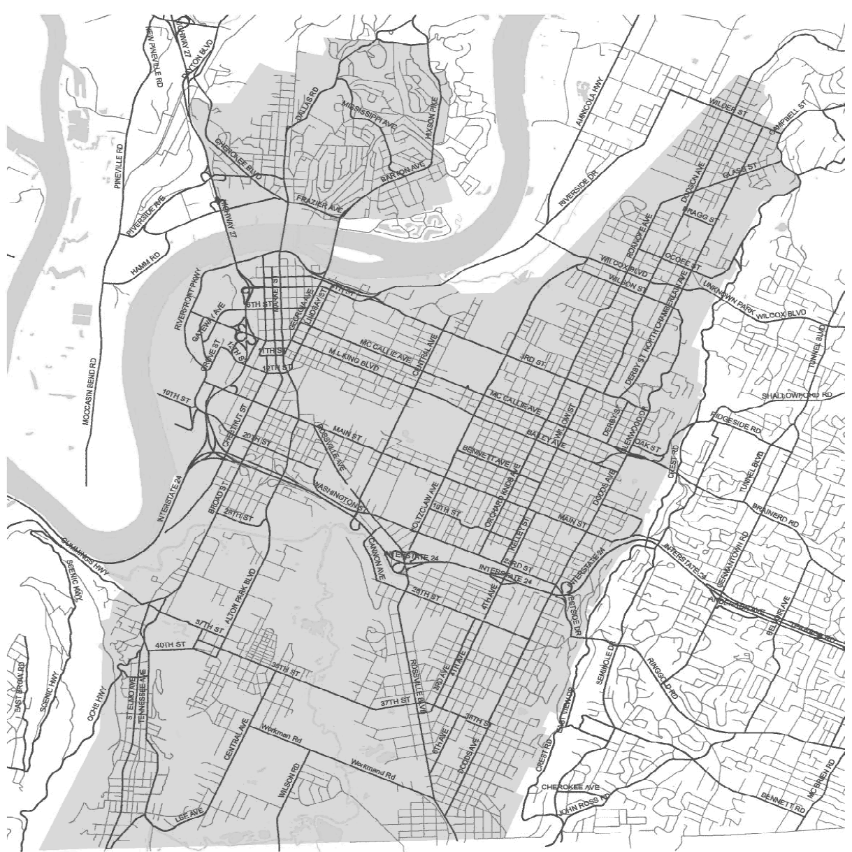
(Ord. No. 14137, § 1, 7-23-24; Ord. No. 14138, § 1, 7-23-24)
Sec. 38-33. - TOD Transit-Oriented Development Overlay Zone
[RESERVED]
(Ord. No. 14137, § 1, 7-23-24; Ord. No. 14138, § 1, 7-23-24)
Sec. 38-34. - Lovell Field Gateway Overlay Zone
(a)
Purpose .....
The intent of the Lovell Field Gateway Overlay Zone is to realize the primary objectives of "BRAINERD ... A Vision for Today"—the community's master plan. Adopted by the Chattanooga City Council in 2011, the Plan's goal is to create a vibrant town center along Brainerd Road that is well connected to adjacent neighborhoods. Specific issues and opportunities identified in the community's master plan and in meetings by the Brainerd community include:
(1)
Poor visual quality in the corridor attributed to sign clutter, overhead utility poles and electrical lines, lack of street trees, varying building setbacks, and poor quality building designs. .....
(2)
Poor walkability and pedestrian connectivity due to large parking lots and multiple curb cuts, gaps in the sidewalk network, and lack of landscaping along the street and in parking lots. .....
(3)
Unsafe cycling conditions due to multiple car/bicycle conflict points from numerous curb cuts, high traffic speeds, and lack of dedicated bike lanes. .....
(4)
Enhance the corridor as it acts as a gateway into the City. .....
(b)
Applicability .....
(1)
The regulations of this Lovell Field Gateway Overlay Zone supplement the regulations of the underlying zone for all properties within the overlay zone area. However, single-unit dwellings are exempt from the Lovell Field Gateway Overlay Zone. .....
(2)
Where the following overlay zone regulations conflict with a standard set out in of the City Code, the regulations of control. .....
(3)
All other City codes, as currently adopted, apply to properties within the Lovell Field Gateway Overlay Zone, except where noted. .....
(4)
The following regulations apply to all properties within the Lovell Field Gateway Overlay Zone. Primary roads within this zone are Airport Road and Shepherd Road/Airport Connector Road. .....
(5)
Properties which choose to pursue dedication of streetscape land to the City must adhere to the following regulations: .....
(i)
Improvements must be installed prior to the start of the property dedication process. .....
(ii)
The City will provide fair market value for property acquisition, if a judge requires this process. .....
(iii)
All discussions for streetscape property dedication to the City must begin with the City of Department of Public Works- Transportation Division. .....
(6)
The overlay zone regulations are divided into two categories: new development and redevelopment. The regulations of this section applies to these two categories as follows: .....
(i)
All new development, both public and private which constitutes one or more of the following situations: .....
a.
Where a building expansion increases the building footprint by more than 50%. .....
b.
Where a parking lot or other pavement expansion of at least ten spaces increases the total number of spaces or paved surface by more than 50%. .....
(ii)
Redevelopment constitutes both public and private projects. For existing buildings and parking facilities, expansion in building footprint or parking spaces will trigger redevelopment regulations based on the Table 38-34.1: Redevelopment—Cumulative Scope of Work as established below. .....
(c)
Maintenance .....
Maintenance of the improvements required in the Lovell Field Gateway Overlay Zone are the responsibility of the property owner.
OVERLAY ZONE MAP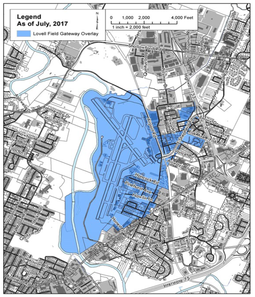
(d)
Redevelopment .....
(1)
Specific Standards .....
Redevelopment that fronts Airport Road and Shepherd Road/Airport Connector Road must comply with the following sections:
(i)
Building Height .....
a.
There is no maximum building height. .....
b.
The minimum building height for properties fronting Airport Road and Shepherd Road/Airport Connector Road is 18 feet. .....
(ii)
Building Materials .....
a.
Brick, natural and architectural cast stone, architectural pre-cast concrete, glass, glass block, architectural metal panel systems, or concrete masonry units with an architectural coloration or finish on the ground floor of building facades are required to provide interest for the pedestrian. Other materials may be used on the upper floors. .....
1.
Metal siding, aluminum siding, vinyl siding, synthetic rock, EIFS (synthetic stucco), or other similar exterior materials are prohibited for large expanses of facades. They may be used as accents. .....
2.
Hard plastic awnings cannot be used. Awnings, when applied, must consist of flexible canvas, acrylic, or vinyl coated material. .....
(iii)
Signs .....
a.
On-Premise Building Signs .....
1.
Within this Overlay Zone, the following regulations are applicable in addition to the general Advertising Provisions in of the Chattanooga City Code. .....
2.
A City of Chattanooga Sign Permit is still required. .....
3.
Structural regulations in the Chattanooga Sign Ordinance still apply to the Lovell Field Gateway Overlay Zone. .....
4.
The Lovell Field Gateway Overlay Zone is exempt from all dimensions, location, and type regulations in the Chattanooga Sign Ordinance. .....
b.
On-Premise Monument Signs .....
1.
A monument sign is defined as an advertising or identification device that is ground mounted and constructed so that there is no space between the ground and the bottom of the device. .....
2.
One monument sign is permitted per parcel. .....
3.
Pole-mounted signs are prohibited. .....
4.
Monument signs cannot exceed six feet in height or ten feet in width. Signs cannot exceed 25 square feet per face and total sign area cannot exceed 50 square feet total of all faces. Height is measured from the top of the sign to the lowest point of the ground upon which the proposed sign is to be located. .....
5.
Monument signs cannot be located in the sight distance triangle or otherwise obstruct lines of sight for vehicular or pedestrian traffic. .....
6.
Monument signs cannot be closer than 18 feet to any right-of-way. .....
7.
Materials that match the materials of the associated building must be used. .....
8.
Signs must be illuminated by indirect lighting. Internally illuminated box-type plastic signs are prohibited, but signs composed of illuminated individual letters are permitted. .....
c.
Off-Premise Billboard Signs .....
Off-premise billboard signs are prohibited.
(iv)
Screening of Utilities .....
a.
Completely screen dumpsters, loading areas, mechanical equipment, outdoor storage areas, and other visible utilities with an opaque wall or fence as follows: .....
b.
The height of the screen must be a minimum of six feet or 12 inches taller than the object, whichever is higher, and adequate to completely conceal the dumpster or equipment. .....
c.
Chain link fences or slats are prohibited. .....
d.
Screens must consist of masonry, stucco, stone, wood, or decorative metal. .....
e.
Landscaping, including shrubs, trees, perennials, or green screens, must be added to screening to soften the appearance of screening walls or fences. .....
(v)
Front Setback .....
Buildings are subject to a build-to zone of 18 feet to 26 feet.
(vi)
Curb Cuts .....
a.
A net increase in the number of curb cuts is prohibited along Airport Road and Shepherd Road/Airport Connector Road. .....
b.
Property owners must meet with the Department of Public Works-Transportation Division to discuss consolidating existing driveways and curb cuts. .....
(vii)
Parking Lot Regulations .....
a.
Parking Location .....
These regulations only apply to new or expanded parking facilities.
1.
The Parking Zone is located to the rear of buildings. .....
2.
New parking is not permitted between a building and the Airport Road and Shepherd Road/Airport Connector Road frontage. .....
3.
If all new parking cannot be accommodated to the rear of the building, parking on the side of the building may be allowed if it is screened from the public right-of-way per this section. .....
4.
Garages for new residential dwellings must be located behind the primary building. .....
b.
Parking Space Regulations .....
1.
The base zone parking space requirements apply. .....
2.
The number of spaces provided cannot exceed the minimum required number of spaces by more than 50%. .....
3.
Public Works-Transportation may allow the following discounts for required car parking spaces. Applicants should schedule a consultation with Public Works-Transportation to determine potential parking discounts. .....
c.
Off-Site Parking .....
1.
40% of required car parking spaces, except required accessible spaces, may be located off-site if the remote parking area is located within 700 feet from the primary entrance of the facility served. .....
2.
On-street parking spaces may be counted as required parking spaces provided the on-street spaces abut the subject property. .....
DEVELOPMENT PROFILE DIAGRAM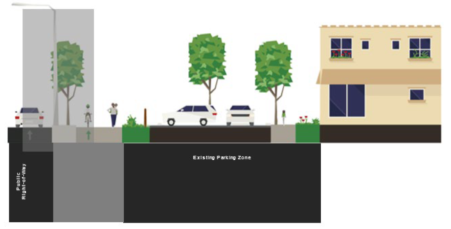
(e)
New Development .....
(1)
Front Setback .....
Buildings are subject to a build-to zone of 18 feet to 26 feet.
(2)
Curb Cuts .....
(i)
Only one Airport Road and Shepherd Road/Airport Connector Road curb cut per 150 linear feet of street frontage is permitted. .....
(ii)
Property owners must meet with the Department of Public Works- Transportation Division to discuss consolidating existing driveways and curb cuts. .....
(3)
Elements Not Permitted .....
The following are not permitted in the front setback:
(i)
Parking .....
(ii)
Chain link or slat fence .....
(iii)
Drive lanes .....
(iv)
HVAC equipment .....
(v)
Dumpsters .....
(4)
Front Setback Materials .....
(i)
Front setbacks do not include paved surfaces. .....
(ii)
Front setbacks may include lawn, shrubs, green infrastructure, street trees, bus shelters, road signage, street and pedestrian lighting. .....
(iii)
Green infrastructure (landscaped planters, bioswales, etc.) may be included. All development must adhere to the City's water quality regulations. Refer to City of Chattanooga's Code, , and the City's Rainwater Management Guide for Green Infrastructure applications. .....
(5)
Street Trees .....
(i)
When warranted, dimensions and locations of street trees will be specified by Department of Public Works- Transportation Division. .....
(ii)
The City's Urban Forester must approve all of the following: .....
a.
Selection of all trees. .....
b.
Removal or pruning of street trees. .....
c.
Construction or demolition of any buildings fronting the zone to ensure the protection of existing trees. .....
(6)
Bus Shelters .....
(i)
Public Works-Transportation will determine if a bus shelter is needed, based on a consultation with the Chattanooga Area Regional Transportation Authority (CARTA). .....
(ii)
Coordinate the placement, design, lighting, and construction of bus shelters with the CARTA and Public Works-Transportation. .....
(7)
Lighting .....
(i)
When warranted, pedestrian and street light design, type, spacing and mounting height are determined by the Department of Public Works- Transportation Division and the Electric Power Board. .....
(ii)
New lighting in the front setback must be aligned with the street trees and parallel to the edge of right-of-way. .....
(iii)
Exterior lighting must be equipped with full cut-offs to direct light downward and to minimize glare, shadows, night sky pollution, and excessive light levels. .....
(8)
Storefront/Building Zone .....
(i)
Dimensions/Location .....
a.
Location .....
The Storefront/Building Zone is located in the build-to zone of 18 feet to 26 feet setbacks fronting Airport Road and Shepherd Road/Airport Connector Road.
b.
Width .....
The Storefront/Building Zone is limited to a maximum of eight feet in width.
c.
Elements Not Permitted .....
The following are not permitted in the Storefront/Building Zone: parking, chain link or slat fence, drive lanes, HVAC equipment, and dumpsters.
(9)
b. Building Height .....
(i)
There is no maximum building height. .....
(ii)
The minimum building height for properties fronting Airport Road and Shepherd Road/Airport Connector Road is 18 feet. .....
(iii)
Building Placement .....
a.
Buildings are subject to a build-to zone of 18 feet to 26 feet fronting Airport Road and Shepherd Road/Airport Connector Road. .....
b.
Primary building entries must be clearly identifiable and visible from the street. .....
(iv)
Building Materials .....
a.
Use brick, natural and architectural cast stone, architectural pre-cast concrete, glass, glass block, architectural metal panel systems, or concrete masonry units with an architectural coloration or finish on the ground floor of building facades to provide interest for the pedestrian. .....
b.
Other materials may be used on the upper floors. .....
c.
Metal siding, aluminum siding, vinyl siding, synthetic rock, EIFS (synthetic stucco), or other similar exterior materials are prohibited for large expanses of facades but may be used as accents. .....
d.
Hard plastic awnings cannot be used. Awnings, when applied, must consist of flexible canvas, acrylic, or vinyl coated material. .....
(10)
Signs .....
(i)
Sign Dimensions .....
a.
Signs on any one side of a building, cannot exceed 1.5 square feet per linear foot of that building side. Awnings and permanent banners used for advertising are considered part of the building signage and square footage calculation. .....
b.
Projecting signs cannot exceed 16 square feet in area. .....
c.
Signs painted on windows cannot cover more than 20% of the total window area. .....
(ii)
b. Sign Locations .....
a.
Projecting signs must be located a minimum of 12 inches below the second story windowsill or top of the building, whichever is lower. .....
b.
Signs must fit within the architectural elements such as in the lintel or sign frieze that separates the ground level from the upper facade, on the upper facade walls, or projecting from the face of the building. .....
c.
Signs cannot obstruct the architectural elements and details of a building. .....
d.
Wall signs must be placed such that they align with other signs on the block. .....
e.
Roof signs are prohibited. .....
1.
For buildings with multiple tenants, signs must be located only on the portions of the building directly outside the area occupied by that tenant or contained within consolidated directories, as defined in the Sign Ordinance. .....
(iii)
Sign Types .....
a.
Signs must be illuminated by indirect lighting. Internally illuminated box-type plastic signs are prohibited, but signs composed of illuminated individual letters are permitted. .....
b.
Temporary signs or banners, regardless of size, are limited to 30 days and require a sign permit, per the Sign Ordinance. .....
c.
Mass produced neon signs are prohibited. .....
(iv)
On-Premise Building Signs .....
The following regulations are applicable in addition to the general Advertising Provisions in of the Chattanooga City Code.
a.
A sign permit is required. .....
b.
Structural regulations in the Sign Ordinance apply to the Lovell Field Gateway Overlay Zone. .....
c.
The Lovell Field Gateway Overlay Zone is exempt from all dimensions, location, and type regulations in the Sign Ordinance. .....
(v)
On-Premise Monument Signs .....
a.
Monument Sign Permissions .....
A monument sign is defined as an advertising or identification device that is ground mounted and constructed so that there is no space between the ground and the bottom of the device.
1.
One monument sign is permitted per parcel. .....
2.
Pole-mounted signs are prohibited. .....
b.
Monument Sign Dimensions/Location .....
1.
Monument signs cannot exceed six feet in height or ten feet in width. Signs cannot exceed 25 square feet per face and total sign area cannot exceed 50 square feet total of all faces. Height is measured from the top of the sign to the lowest point of the ground upon which the proposed sign is to be located. .....
2.
Monument signs cannot be located in the sight distance triangle or otherwise obstruct lines of sight for vehicular or pedestrian traffic. .....
3.
Monument signs cannot be closer than 18 feet to any right-of-way. .....
c.
Monument Sign Materials .....
Materials that match the materials of the associated building must be used.
d.
Monument Sign Illumination .....
Signs must be illuminated by indirect lighting. Internally illuminated box-type plastic signs are prohibited, but signs composed of illuminated individual letters are permitted.
(vi)
Off-Premise Billboard Signs .....
Off-premise billboard signs are prohibited.
(11)
Parking Zone .....
PARKING ZONE BEHIND BUILDINGS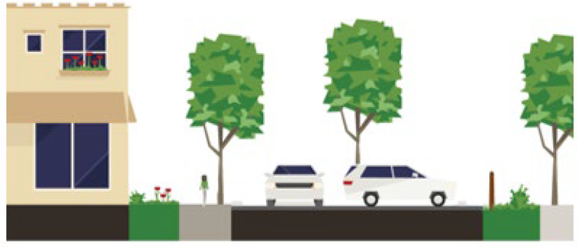
(a)
Location .....
(1)
The Parking Zone is located to the rear of buildings. .....
(2)
New parking is not permitted between a building and the Airport Road and Shepherd Road/Airport Connector Road frontage. .....
(3)
If all new parking cannot be accommodated to the rear of the building, parking on the side of the building may be allowed if it is screened from the public right-of-way per this section. .....
(4)
Garages for new residential dwellings must be located behind the primary building. .....
(b)
Parking Space Regulations .....
(1)
The base zone parking space requirements apply. .....
(2)
The number of spaces provided cannot exceed the minimum required number of spaces by more than 50%. .....
(3)
Public Works-Transportation may allow the following discounts for required car parking spaces. Applicants should schedule a consultation Public Works-Transportation with Public Works-Transportation to determine potential parking discounts. .....
(i)
One car parking space may be discounted for every bicycle parking space required. .....
(ii)
If the development connects via new or existing sidewalks to an established sidewalk grid that links multiple land uses (i.e., commercial, residential, office), a 10% discount may be applied. .....
(iii)
If the development is located within one-quarter mile of an established transit stop, a 10% discount may be applied. .....
(iv)
Parking space discounts may be applied to developments that share parking with facilities serving other uses according to the following chart: .....
a.
Shared parking discounts are applied before multi-modal discounts .....
b.
To apply shared parking discounts for facilities on separate parcels, a legal agreement between property owners guaranteeing access to and use of designated parking areas is required. .....
(c)
Off-Site Parking .....
(i)
40% of required car parking spaces, except required accessible spaces, may be located off-site if the remote parking area is located within 700 feet from the primary entrance of the facility served. .....
(ii)
On-street parking spaces may be counted as required parking spaces provided the on-street spaces abut the subject property. .....
(d)
Parking Lot Lighting .....
(i)
All parking lot lighting must be equipped with full cut-offs to direct light downward and to minimize glare, shadows, night sky pollution, and excessive light levels. .....
(ii)
Light spill on neighboring property is prohibited. .....
(iii)
Maximum mounting height of light fixtures in parking lots is 20 feet. .....
(e)
Green Infrastructure .....
(i)
All development must adhere to the City's water quality regulations. Refer to City of Chattanooga's Code, , and the City's Rainwater Management Guide for Green Infrastructure applications. .....
(f)
Screening of Utilities .....
Completely screen dumpsters, loading areas, mechanical equipment, outdoor storage areas, and other visible utilities with an opaque wall or fence as follows:
(g)
The height of the screen must be a minimum of six feet, or 12 inches taller than the object, whichever is higher, and adequate to completely conceal the dumpster or equipment. .....
(h)
Chain link fences or slats are prohibited. .....
(i)
Screens must consist of masonry, stucco, stone, wood, or decorative metal. .....
(j)
Landscaping, including shrubs, trees, perennials, or green screens, must be added to screening to soften the appearance of screening walls or fences. .....
NEW DEVELOPMENT PROFILE DIAGRAM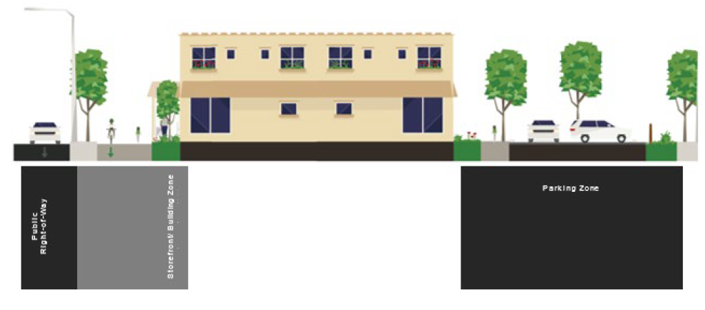
(Ord. No. 14137, § 1, 7-23-24; Ord. No. 14138, § 1, 7-23-24)
Sec. 38-35. - Brainerd Overlay Zone Standards
(1)
Intent. The intent of the Brainerd Road Overlay Zone is to realize the primary objectives of "BRAINERD ... a vision for Today"—the community's master plan. Adopted by the Chattanooga City Council in 2011, the Plan's goal is to create a vibrant town center along Brainerd Road that is well connected to adjacent neighborhoods. Specific issues identified in the community's master plan and in meetings by the Brainerd community include: .....
(a)
Poor visual quality in the corridor attributed to: sign clutter, overhead utility poles and electrical lines, lack of street trees, varying building setbacks, and poor quality building designs. .....
(b)
Poor walkability and pedestrian connectivity due to: large parking lots and multiple curb cuts, gaps in the sidewalk network, and lack of landscaping along the street and in parking lots. .....
(c)
Unsafe cycling conditions due to: multiple car/bicycle conflict points from numerous curb cuts, high traffic speeds, and lack of dedicated bike lanes. .....
(2)
Applicability. .....
(a)
The regulations of this Brainerd Overlay Zone shall supplement the regulations of the underlying zoning for all properties within the Overlay Zone area. .....
(b)
Where the following Overlay Zone regulations conflict with a standard set out in Chapter 8-Aviation, the regulations of shall prevail. .....
(c)
All other City codes, as currently adopted, apply to properties within the Brainerd Overlay Zone, except where noted. .....
(d)
The following development regulations apply to ALL properties within the boundaries of this Overlay Zone of Brainerd Road and Lee Highway from the Spring Creek Road intersection to the TN-153 intersection (see Figure 1. Overlay Zone Map). .....
Figure 1. Overlay Zone Map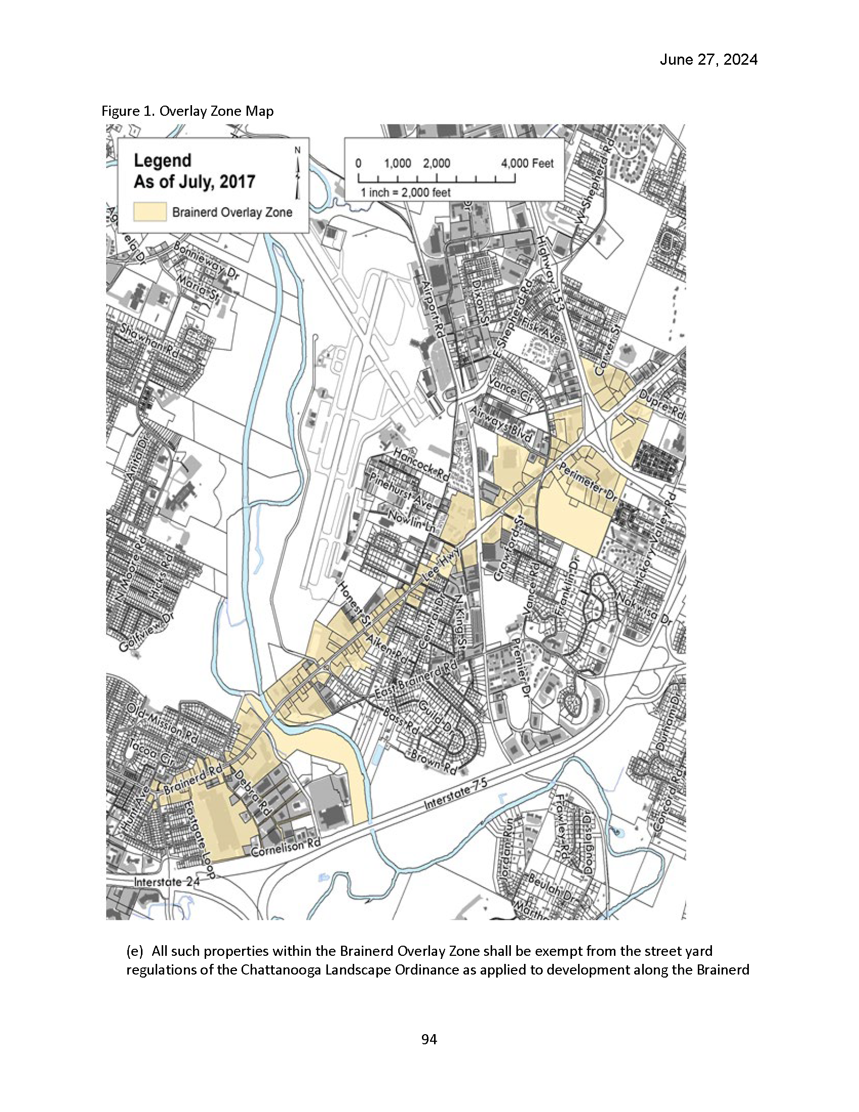
(e)
All such properties within the Brainerd Overlay Zone shall be exempt from the street yard regulations of the Chattanooga Landscape Ordinance as applied to development along the Brainerd Road and Lee Highway's edge of rights-of-way. The Chattanooga Landscape Ordinance street yard regulations shall only apply to side street frontages within these boundaries. .....
(f)
All such properties may provide voluntary dedication of Street Edge Zone and Bike/Ped Zone right-of-way improvements for those portions outside the current public right-of-way to the City of Chattanooga which will be beneficial to connectivity and public safety for all citizens within the Overlay Zone. .....
i.
Any right-of-way Improvements shall be installed prior to the start of the property dedication process to the City; and .....
ii.
Should there be a need for involuntary dedication for properties without Street Edge zone and/or Bike/Ped connectivity improvements, the City will provide fair market value for any necessary property acquisition beneficial to connectivity and public safety after voluntary dedication has been requested; and .....
iii.
All discussions for dedication of Street Edge Zone and Bike/Ped Zone right-of-way improvements to the City of Chattanooga within this Overlay Zone shall begin with the City of Department of Public Works- Transportation Division before any building permit is issued by the Land Development Office. .....
(g)
The Overlay Zone Regulations are divided into two categories: New Development and Redevelopment. The regulations of this Section shall apply to these two (2) categories as follows: .....
i.
New Development, both public and private, constitutes one (1) or more of the following situations: .....
a.
New Construction of a stand alone building for use as leasable space. .....
b.
Where a building expansion increases the building footprint by more than fifty percent (50%). .....
c.
Where a parking lot or other pavement expansion of at least ten (10) spaces increases the total number of spaces or paved surface by more than fifty percent (50%). .....
ii.
Redevelopment shall constitute both public and private projects. For existing buildings and parking facilities, expansion in building footprint or parking spaces will trigger Redevelopment regulations based on the cumulative scope of work as established below. .....
(h)
Regulations Table (Based on Scope of Work). .....
(i)
Building Expansion. .....
i.
Where a building expansion increases building footprint less than ten percent (10%), the entire property shall comply with the Screening of Utilities regulations of this chapter in Section (5)(i). .....
ii.
Where a building expansion increases building footprint at least ten percent (10%) but no more than twenty-five percent (25%): .....
a.
The entire property shall comply with the Screening of Utilities regulations in Section (5)(i), and .....
b.
The entire property shall comply with all Signage regulations per this chapter, Sections (5)(d),(5)(e),(5)(f). .....
iii.
Where a building expansions increases building footprint more than twenty-five percent (25%) but no more than fifty percent (50%): .....
a.
The entire property shall comply with the Screening of Utilities regulations in Section (5)(i); .....
b.
The entire property shall comply with all Signage regulations of this chapter, Sections (5)(d),(5)(e),(5)(f); .....
c.
Fifty percent (50%) of the existing parking lot and all of any expanded portions of the parking lot shall comply with the Parking Lot regulations, Section (4)(d) and (5)(h)(iv); and .....
d.
The entire property shall comply with the New Development Street Edge Zone and Bike/Pedestrian Zone regulations, Sections (5)(a), (5)(b). .....
iv.
Where a building expansion increases building footprint more than fifty percent (50%), the entire property shall comply with all regulations of this Division. .....
(j)
Parking Lot Expansion .....
i.
Where a parking lot expansion of at least ten (10) spaces increases the total number of parking spaces by less than ten percent (10%), the entire property shall comply with the Screening of Utilities regulations Section (5)(i). .....
ii.
Where a parking lot expansion of at least ten (10) spaces increases the total number of parking spaces by at least ten percent (10%) and no more than twenty-five percent (25%): .....
a.
The entire property shall comply with the Screening of Utilities regulations in Section (5)(i); .....
b.
The entire property shall comply with all Signage regulations per this chapter, Sections (5)(d),(5)(e),(5)(f); and .....
c.
The expanded portion of the parking lot shall comply with the Parking Lot regulations, Section (4)(d) and (5)(h)(iv). .....
iii.
Where a parking lot expansion of at least ten (10) spaces increases the total number of parking spaces more than twenty-five percent (25%) but no more than fifty percent (50%): .....
a.
The entire property shall comply with the Screening of Utilities regulations in Section (5)(i); .....
b.
The entire property shall comply with all Sign regulations per this chapter, Sections (5)(d),(5)(e),(5)(f); .....
c.
The expanded portion of the parking lot and fifty percent (50%) of the existing parking lot shall comply with the Parking Lot regulations, Section (4)(d) and (5)(h)(iv); and .....
d.
The entire property shall comply with the New Development Street Edge Zone and Bike/Pedestrian Zone regulations, Sections (5)(a), (5)(b). .....
iv.
Where a parking lot expansion of at least ten (10) spaces increases the total number of parking spaces more than fifty percent (50%), the entire property, including the expanded parking lot portion, shall comply with all regulations of this Division. .....
(k)
All signs shall adhere to all Sign regulations of this chapter, Sections (5)(d),(5)(e),(5)(f), as signs are replaced, repaired, and/or added. .....
(3)
Maintenance. Maintenance of the improvements required in the Brainerd Overlay Zone shall be the responsibility of the property owner. .....
(4)
Redevelopment. See Figure 2. Redevelopment Profile Diagram. .....
Figure 2. Redevelopment Profile Diagram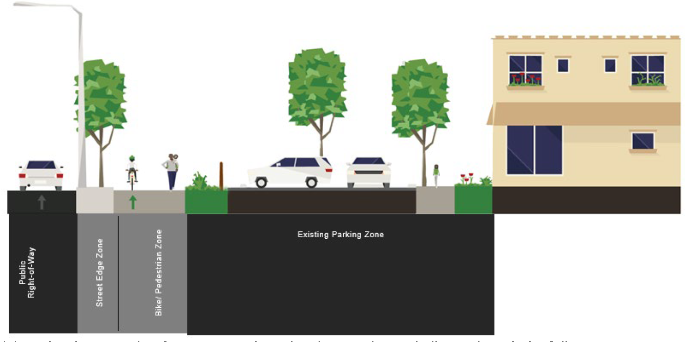
(a)
Redevelopment that fronts Brainerd Road and Lee Highway shall comply with the following sections: .....
i.
Street Edge Zone as defined in Section (5)(a), .....
ii.
Bike/Pedestrian Zone as defined in Section (5)(b), .....
iii.
Building Height as defined in Section (5)(c)(ii), .....
iv.
Building Materials as defined in Section (5)(c)(v), .....
v.
On-premise Building Signs as defined by Section (5)(d), .....
vi.
On-premise Monument Signs as defined by Section (5)(e), and .....
vii.
Off-premise Billboard Signs. Off-premise billboard signs shall not be permitted. .....
viii.
Screening of Utilities as defined in Section (5)(i). .....
(b)
Front Setback. Buildings shall have a maximum front setback of twenty-six (26) feet. .....
(c)
Curb Cuts. .....
i.
A net increase in the number of curb cuts shall not be permitted along Brainerd Road and Lee Highway. .....
ii.
Property owners shall meet with the Department of Public Works- Transportation Division to discuss consolidating existing driveways and curb cuts. .....
(d)
Parking Lot Regulations. .....
i.
Perimeter Screening of Existing Parking Lots. .....
a.
Location. Screening materials shall be placed parallel to the edge of the Bike/Pedestrian Zone, accommodating curb cuts and behind the traffic sight triangle at intersections and driveways. See the Chattanooga City Code () for sight triangle distance regulations. www.chattanooga.gov .....
b.
Dimensions. .....
1.
Screening shall have a minimum height of three (3) feet and a maximum height of four (4) feet above grade, and shall be nearly opaque to screen the parking from view. .....
2.
Height is measured from the grade level of that which is being screened. .....
3.
When landscape is used, the planting area shall have a minimum horizontal depth of four (4) feet. .....
c.
Materials. .....
1.
Perimeter screening of existing parking lots shall consist of perimeter landscape plantings, decorative masonry wall, or a combination of a decorative fence and landscape shrubs, approved by the City Landscape Architect. .....
2.
All shrubs shall be installed at a minimum height of twenty-four (24) inches and spaced to create a complete screen within three (3) years after planting. .....
3.
Landscape shrubs shall be maintained to achieve the minimum height of three (3) feet above grade or one hundred percent (100%) coverage shall be achieved within three (3) years of planting. Seventy-five percent (75%) of the plant material should be evergreen. If coverage is not obtained within three (3) years, supplemental plantings shall be required. .....
ii.
Shade Trees in Parking Lot. .....
a.
In addition to minimum Chattanooga Landscape Ordinance regulations, parking Lot Shade Trees shall be provided at a minimum rate of one (1) two and one-half (2.5) inch caliper tree for every seven (7) parking spaces. .....
b.
If there is insufficient space to provide the required quantity of two and one-half (2.5) inch caliper shade trees due to conflicts with utilities, easements, or existing underground structures, a lesser quantity of larger caliper trees shall be provided. The quantity of larger trees shall be determined by calculating the total caliper inches required. Any combination of larger caliper trees shall be provided to meet that total. (For example, ten (10) two and one-half (2.5) inch caliper trees shall be required for seventy (70) parking spaces, therefore a total of twenty-five (25) caliper inches shall be provided through any combination of larger sized trees.) .....
c.
A shade tree shall be provided within forty (40) feet of every parking space, to ensure shade coverage throughout the parking lot. .....
iii.
Parking Location. See Section (5)(h)(i). Note that the location regulations only apply to new or expanded parking facilities, not the existing parking lot. .....
iv.
Parking Space Regulations. See Section (5)(h)(ii). .....
v.
Off-Site Parking. See Section (5)(h)(iii). .....
Figure 3. New Development Profile Diagram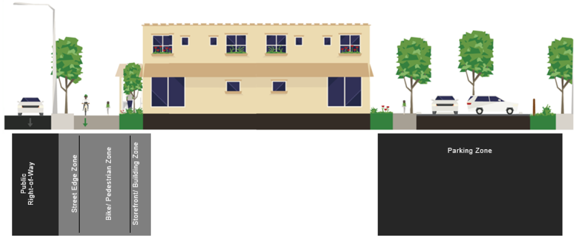
(5)
New Development. See Figure 3. New Development Profile Diagram. .....
(a)
Street Edge Zone. See Figure 4. Diagram of Street Edge, Bike/Pedestrian, & Storefront/Building Zones. .....
i.
Dimensions / Location. .....
a.
Location. The Street/Edge Zone is located: .....
1.
Between the edge of the public right-of-way and the Bike/Pedestrian Zone; and .....
2.
Parallel to the edge of the right-of-way. .....
3.
Place trees, shrubs and other elements behind the traffic sight triangle at intersections and driveways. If these elements are necessary within the traffic sight triangle, limit their height to (3) three feet. See the Chattanooga City Code () for sight distance triangle regulations. www.chattanooga.gov. .....
b.
Length. Twelve (12) feet minimum. For the health of trees located in them, planting strips shall be twelve (12) feet minimum in length. .....
c.
Width. Six (6) feet minimum, extends to the bike/pedestrian zone, excluding the curb dimensions. .....
d.
Clear Path. Any vertical streetscape elements placed in the Street Edge Zone, such as street trees, bus shelters or lighting, shall be placed a minimum of 1.5 feet from the face of curb. The applicant shall refer to AASHTO's Roadside Design Guide for further information and guidance on roadside construction design specifications. .....
ii.
Curb Cuts. .....
a.
Only one (1) Brainerd Road and/or Lee Highway curb cut per one hundred fifty (150) linear feet of street frontage is permitted. .....
b.
Property owners shall meet with the Department of Public Works- Transportation Division to discuss consolidating existing driveways and curb cuts. .....
iii.
Elements Not Permitted. The following shall not be permitted in the Street Edge Zone: parking, chain link or slat fence, drive lanes, HVAC equipment and dumpsters. .....
iv.
Street Edge Zone Materials. .....
a.
Shall include street trees. .....
b.
Shall not include paved surfaces. .....
c.
May include lawn, shrubs, green infrastructure, bus shelters, road signage, street and pedestrian lighting. .....
d.
Green Infrastructure (landscaped planters, bioswales, etc.). All development shall adhere to the City's water quality regulations. Refer to City of Chattanooga's Code, and the City's Rainwater Management Guide for Green Infrastructure applications. .....
v.
Street Trees. .....
a.
Dimensions/ Location. Trees shall be provided at a rate of one (1) tree per thirty-five (35) linear feet of street frontage. Actual street tree spacing will reflect a twenty-five (25) or thirty (30) foot rhythm as determined by the Department of Public Works- Transportation Division. .....
b.
The City's Urban Forester shall approve all of the following in the Street Edge Zone: .....
1.
Selection of all trees; and .....
2.
Removal or pruning of trees; and .....
3.
Construction or demolition of any buildings fronting the Zone to ensure the protection of existing trees. .....
vi.
Bus Shelters. .....
a.
The Department of Public Works- Transportation Division (CDOT) will determine if a bus shelter is needed, based on a consultation with the Chattanooga Area Regional Transportation Authority (CARTA). .....
b.
Coordinate the placement, design, lighting and construction of bus shelters with the CARTA and Public Works-Transportation. .....
vii.
Lighting. .....
a.
Pedestrian and street light design, type, spacing and mounting height shall be determined by the Department of Public Works- Transportation Division and the Electric Power Board. .....
1.
New lighting in the Street Edge Zone shall be aligned with the street trees and parallel to the edge of right-of-way. .....
2.
Exterior lighting shall be equipped with full cut-offs to direct light downward and to minimize glare, shadows, night sky pollution, and excessive light levels. .....
Figure 4. Diagram of Street Edge, Bike/Pedestrian, & Storefront/Building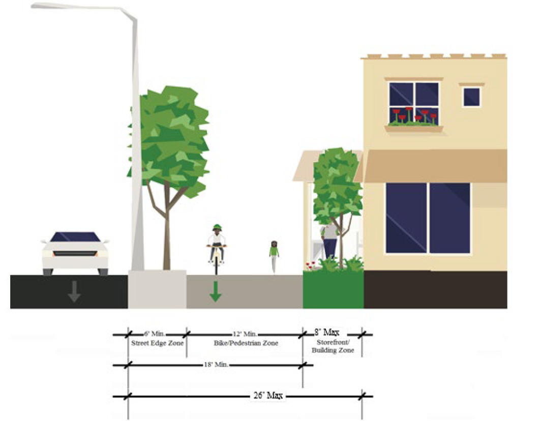
(b)
Bike/Pedestrian Zone. .....
i.
Location. The Bike/Pedestrian Zone is located between the Street Edge Zone and the Storefront/Building Zone. .....
ii.
Elements Not Permitted. .....
a.
The following are not permitted in this Zone: parking, chain link or slat fence, drive lanes, HVAC equipment and dumpsters. .....
b.
For safety reasons, building doors shall not open across or onto the Bike/Pedestrian Zone. .....
iii.
Multi-use Path. .....
a.
Width. Twelve (12) feet minimum. .....
b.
Materials. Property owners shall meet with the Department of Public Works- Transportation Division to discuss materials. .....
c.
Continental crosswalk pavement markings. Place a crosswalk at the intersection of the multi-use path and any drive aisles. Continental crosswalks feature a series of closely spaced two-foot wide solid white painted lines (longitudinal lines) paired with a limit (stop) line set back from the crosswalk to reduce vehicular encroachment into the crosswalk. .....
(c)
Storefront/Building Zone. .....
i.
Dimensions/Location. .....
a.
Location. The Storefront/Building Zone is located between the Bike/Pedestrian Zone and all buildings fronting Brainerd Road and Lee Highway. .....
b.
Width. Eight (8) feet maximum. .....
c.
Elements Not Permitted. The following are not permitted in this Zone: parking, chain link or slat fence, drive lanes, HVAC equipment and dumpsters. .....
ii.
Building Height. .....
a.
No maximum building height. .....
b.
The minimum building height for properties fronting Brainerd Road and Lee Highway shall be eighteen (18) feet. .....
iii.
Building Placement. .....
a.
Front Setback. Buildings shall have a maximum front setback of twenty-six (26) feet and a minimum setback of eighteen (18) feet fronting Brainerd Road and Lee Highway. .....
b.
Buildings shall be built to the multi-use path, except in the following circumstance. .....
1.
If an outdoor cafe or landscaped space is provided between the Bike/Pedestrian Zone and the building, then the building may be set back a maximum of eight (8) feet from the Bike/Pedestrian Zone. .....
2.
If the building is set back from the Bike/Pedestrian Zone, a pedestrian walkway shall be provided from the multi-use path to the primary building entrance. .....
c.
Primary building entries shall be clearly identifiable and visible from the street. .....
iv.
Outdoor Cafe/Landscaped Space. .....
a.
Incorporate planters, landscaping, decorative fencing, hedges, low walls, benches or other architectural elements, to frame and define the edge of the landscaped lawns, porches, patios, entry plazas, fountains, outdoor cafes and other man-made spaces. .....
b.
Plant Materials: Plant trees, shrubs, vegetated groundcovers, ornamental grasses, and/or perennials in landscape beds, raised beds, lawns, planters, or tree wells. .....
v.
Building Materials. .....
a.
Use brick, natural and architectural cast stone, architectural pre-cast concrete, glass, glass block, architectural metal panel systems, or concrete masonry units with an architectural coloration or finish on the ground floor of building facades to provide interest for the pedestrian. .....
b.
Other materials may be used on the upper floors. .....
c.
Metal siding, aluminum siding, vinyl siding, synthetic rock, EIFS (synthetic stucco), or other similar exterior materials shall not be used for large expanses of facades. They may be used as accents. .....
d.
Hard plastic awnings shall not be used. Awnings, when applied, shall consist of flexible canvas, acrylic, or vinyl coated material. .....
(d)
On-premise Building Signs. .....
i.
Within this Overlay Zone, the following regulations are applicable in addition to the general Advertising Provisions in of the Chattanooga City Code. .....
ii.
A City of Chattanooga Sign Permit is still required. .....
iii.
Structural regulations in the Chattanooga Sign Ordinance still apply to the Brainerd Road Overlay Zone. .....
iv.
The Brainerd Road Overlay Zone is exempt from all dimensions, location and type regulations in the Chattanooga Sign Ordinance. .....
v.
Dimensions. .....
a.
Signs on any one (1) side of a building, shall not exceed one and one half (1.5) square feet per linear foot of that building side. Awnings and permanent banners used for advertising are considered part of the building signage and square footage calculation. .....
b.
Projecting signs shall not exceed sixteen (16) square feet in area. .....
c.
Signs painted on windows shall not cover more than twenty percent (20%) of the total window area. .....
vi.
Location. .....
a.
Projecting signs shall be located a minimum of 12 inches below the second story window sill or top of the building, whichever is lower. .....
b.
Signs shall be located to fit within the architectural elements such as in the lintel or sign frieze that separates the ground level from the upper facade, on the upper facade walls, or projecting from the face of the building. .....
c.
Signs shall not obstruct the architectural elements and details of a building. .....
d.
Wall signs shall be placed such that they align with other signs on the block. .....
e.
Roof signs shall not be incorporated. .....
f.
For buildings with multiple tenants, signs shall be located only on the portions of the building directly outside the area occupied by that tenant or contained within consolidated directories, as defined in the City Sign Ordinance. .....
vii.
Type. .....
a.
Signs shall be illuminated by indirect lighting. Internally illuminated box-type plastic signs shall not be permitted, but signs composed of illuminated individual letters shall be permitted. .....
b.
Temporary signs or banners, regardless of size, shall only remain in place for 30 days and require a sign permit, per the Chattanooga Sign Ordinance. .....
c.
Mass produced neon signs shall not be permitted. .....
(e)
On-premise Monument Signs. .....
i.
Monument Sign. .....
a.
A monument sign is defined as an advertising or identification device that is ground mounted and constructed so that there is no space between the ground and the bottom of the device. .....
b.
One monument sign is permitted per parcel. .....
c.
Pole-mounted signs shall not be permitted. .....
ii.
Dimensions/ Location. .....
a.
Monument signs shall not exceed six feet (6') in height or ten feet (10') in width. Signs shall not exceed twenty-five (25) square feet per face and total sign area shall not exceed fifty (50) square feet total of all faces. Height is measured from the top of the sign to the lowest point of the ground upon which the proposed sign is to be located. .....
b.
Monument signs shall not be located in the sight distance triangle or otherwise obstruct lines of sight for vehicular or pedestrian traffic. .....
c.
Monument signs shall not be closer than eighteen (18) feet to any right-of-way, and shall not be located in the Street Edge Zone or Bike/Pedestrian Zone. .....
iii.
Materials. Materials that match the materials of the associated building shall be used. .....
iv.
Illumination. .....
a.
Signs shall be illuminated by indirect lighting. Internally illuminated box-type plastic signs shall not be permitted, but signs composed of illuminated individual letters shall be permitted. .....
(f)
Off-premise Billboard Signs. Off premise billboard signs shall not be permitted. .....
(g)
Bike Racks. .....
i.
Bike Racks are not required, but when provided they shall adhere to the following regulations. .....
a.
Each bicycle parking space shall be at least six feet long by two feet wide; and .....
b.
Shall be located within fifty (50) feet of the building entrance. .....
c.
Bicycle parking racks shall be securely attached to the ground and provide support for a bicycle frame at two points. .....
(h)
Parking Zone. .....
i.
Location. .....
a.
The Parking Zone is located to the rear of buildings. .....
b.
New parking shall not be permitted between a building and the Brainerd Road and/or Lee Highway street frontage. .....
Figure 5. Parking Zone Behind Buildings
c.
If all new parking cannot be accommodated to the rear of the building, parking on the side of the building may be allowed if it is screened from the public right-of-way as described in Section (4)(d). .....
d.
Parking areas shall be connected to parking and access drives of adjacent properties to provide cross-connection. Fences and other barriers shall be removed that prevent interconnection for cars and pedestrians. .....
e.
Garages for new residential dwellings shall be located behind the primary building. .....
ii.
Parking Space Regulations .....
a.
Reference Table 1700 (Article V, Section 38-471) and the underlying Zone for the required number of parking spaces. .....
b.
The number of spaces provided shall not exceed the required number of spaces by more than fifty percent (50%). .....
c.
A minimum of four (4) bicycle parking spaces are required, plus one bicycle parking space for every fifty (50) required car parking spaces. .....
d.
Parking Discounts. Public Works-Transportation may allow the following discounts for required car parking spaces. Applicants should schedule a consultation with Public Works-Transportation to determine potential parking discounts. .....
1.
Bicycle. One (1) car parking space may be discounted for every bicycle parking space required. .....
2.
Pedestrian. If the development connects via new or existing sidewalks to an established sidewalk grid that links multiple land uses (i.e. commercial, residential, office), a ten percent (10%) discount may be applied. .....
3.
Transit. If the development is located within one-quarter (1/4) mile of an established transit stop, a ten percent (10%) discount may be applied. .....
e.
Shared Parking. Parking space discounts may be applied to developments that share parking with facilities serving other uses according to the following chart: .....
1.
Shared parking discounts are applied before multi-modal discounts .....
2.
To apply shared parking discounts for facilities on separate parcels, a legal agreement between property owners guaranteeing access to and use of designated parking areas is required. .....
iii.
Off-Site Parking. .....
a.
Forty percent (40%) of required car parking spaces, except required accessible spaces, may be located off-site if the remote parking area is located within 700 feet from the primary entrance of the facility served. .....
b.
On-street parking spaces may be counted as required parking spaces provided the on-street spaces abut the subject property. .....
iv.
Parking Lot Lighting. .....
a.
All parking lot lighting shall be equipped with full cut-offs to direct light downward and to minimize glare, shadows, night sky pollution, and excessive light levels. .....
b.
Light spill on neighboring property shall not be permitted. .....
c.
Maximum mounting height of light fixtures in parking lots shall be twenty (20) feet. .....
v.
Shade Trees / Landscape / Green Infrastructure. .....
a.
All development shall adhere to the City's water quality regulations. Refer to City of Chattanooga's Code, and the City's Rainwater Management Guide for Green Infrastructure applications. .....
b.
See Section (4)(d) for required parking lot shade tree regulations. .....
(i)
Screening of Utilities. Completely screen dumpsters, loading areas, mechanical equipment, outdoor storage areas, and other visible utilities with an opaque wall or fence as follows: .....
i.
The height of the screen shall be a minimum of six (6) feet, or twelve (12) inches taller than the object, whichever is higher, and adequate to completely conceal the dumpster or equipment. .....
ii.
Chain link fences or slats shall not be permitted. .....
iii.
Screens shall consist of masonry, stucco, stone, wood, or decorative metal. .....
iv.
Landscaping, including shrubs, trees, perennials, or green screens, shall be added to screening to soften the appearance of screening walls or fences. .....
(Ord. No. 14137, § 1, 7-23-24; Ord. No. 14138, § 1, 7-23-24)
Sec. 38-36. - FAA Aviation Overlay Zone
Property within the FAA Aviation Overlay Zone, as defined in of the Chattanooga City Code and shown on the AOD Map, attached as Appendix A to , are subject to additional requirements described in in addition to the requirements set forth of this Code.
(Ord. No. 14137, § 1, 7-23-24; Ord. No. 14138, § 1, 7-23-24)
Sec. 38-37. - Airport Use Zone
(a)
Property Owned by Chattanooga Metropolitan Airport Authority .....
Property within the Airport Use Zone, as defined in Chattanooga City Code and shown on the Airport Use Zone Map, attached as Appendix B to Chattanooga City Code , which is owned by the Chattanooga Metropolitan Airport Authority, is governed by the permitted uses and requirements described in Chattanooga City Code and the zones of this Zoning Code do not apply.
(b)
Property Not Owned by Chattanooga Metropolitan Airport Authority .....
For all property owners of land within the Airport Use Zone, except for the Chattanooga Metropolitan Airport Authority, the zones and requirements described in this Zoning Code apply and the Airport Use Zone, as described in Chattanooga City Code , has no effect.
(Ord. No. 14137, § 1, 7-23-24; Ord. No. 14138, § 1, 7-23-24)
Sec. 38-38. - Special Flood Hazard Area
(a)
Applicability. .....
This section shall apply to all areas within the incorporated area of the City of Chattanooga, Tennessee.
(i)
Statutory Authorization. .....
(1)
The Legislature of the State of Tennessee has in Sections 13-7-201 through 13-7-210, Tennessee Code Annotated delegated the responsibility to local governmental units to adopt regulations designed to promote the public health, safety, and general welfare of its citizenry. Therefore, the City of Chattanooga, Tennessee, Mayor and the Chattanooga City Council, do ordain as follows: .....
(ii)
Finding of Facts. .....
(1)
The City of Chattanooga, Tennessee, Mayor and its City Council wishes to MAINTAIN eligibility in the National Flood Insurance Program (NFIP) and in order to do so must meet the NFIP regulations found in Title 44 of the Code of Federal Regulations (CFR), Ch. 1, Section 60.3. .....
(2)
Areas of the City of Chattanooga, Tennessee are subject to periodic inundation which could result in loss of life and property, health and safety hazards, disruption of commerce and governmental services, extraordinary public expenditures for flood protection and relief, and impairment of the tax base, all of which adversely affect the public health, safety and general welfare. .....
(3)
Flood losses are caused by the cumulative effect of obstructions in floodplains, causing increases in flood heights and velocities; by uses in flood hazard areas which are vulnerable to floods; or construction which is inadequately elevated, floodproofed, or otherwise unprotected from flood damages. .....
(iii)
Purpose. .....
It is the purpose of this section to promote the public health, safety and general welfare and to minimize public and private losses due to flood conditions in specific areas. This section is designed to:
1.
Regulate development in the flood hazard areas of the City of Chattanooga. These flood hazard areas are subject to periodic inundation, which may result in loss of life and property, health and safety hazards, disruption of commerce and governmental services, extraordinary public expenditures for flood protection and relief, and impairment of the tax base; .....
2.
Restrict or prohibit uses which are vulnerable to flooding or erosion hazards, or which result in damaging increases in erosion, flood heights, or velocities; .....
3.
Require that uses vulnerable to floods, including community facilities, be protected against flood damage at the time of initial construction; .....
4.
Control the alteration of natural floodplains, stream channels, and natural protective barriers which are involved in the accommodation of floodwaters; .....
5.
Control filling, grading, dredging and other development which may increase flood damage or erosion; .....
6.
Prevent or regulate the construction of flood barriers which will unnaturally divert flood waters or which may increase flood hazards to other lands; .....
7.
Promote sound land use practices - floodplains are a land resource to be developed in a manner which will result in minimum loss of life and threat to health, and reduction of private and public economic loss caused by flooding; and .....
8.
Preserve the natural characteristics and functions of watercourses and floodplains in order to moderate flood and stormwater impacts, improve water quality, reduce soil erosion, protect aquatic and riparian habitat, provide recreational opportunities, provide aesthetic benefits and enhance community and economic development. .....
(iv)
Floodplain Definitions. .....
For the purposes of this section of the ordinance, the following definitions apply:
Development. Any man-made change to improved or unimproved real estate, including, but not limited to, buildings or other structures, mining, dredging, filling, grading, paving, excavating, drilling operations, or storage of equipment or materials.
Exception. A waiver from the provisions of this Ordinance which relieves the applicant from the requirements of a rule, regulation, order or other determination made or issued pursuant to this Ordinance.
Variance. A grant of relief from the requirements of this Ordinance.
(v)
Objectives. .....
The objectives of this Ordinance are:
(1)
To protect human life, health, safety and property; .....
(2)
To minimize expenditure of public funds for costly flood control projects; .....
(3)
To minimize the need for rescue and relief efforts associated with flooding and generally undertaken at the expense of the general public; .....
(4)
To minimize prolonged business interruptions; .....
(5)
To minimize damage to public facilities and utilities such as water and gas mains, electric, telephone and sewer lines, streets and bridges located in floodprone areas; .....
(6)
To help maintain a stable tax base by providing for the sound use and development of floodprone areas to minimize blight in flood areas; .....
(7)
To ensure that potential homebuyers are notified that property is in a floodprone area; and .....
(8)
To MAINTAIN eligibility for participation in the NFIP. .....
(vi)
Abrogation and Greater Restrictions. .....
It is not intended by this ordinance to repeal, abrogate, or impair any existing easements, covenants, or other private agreements. The standards in this ordinance take precedence over any less restrictive, conflicting local laws, ordinances, or codes. However, where this section conflicts or overlaps with another regulatory instrument, whichever imposes the more stringent restrictions shall prevail.
(vii)
Interpretation. .....
In the interpretation and application of these regulations, all provisions must be:
(1)
Considered as minimum requirements. .....
(2)
Liberally construed in favor of the governing body. .....
(3)
Deemed neither to limit nor repeal any other powers granted under state statutes. .....
(viii)
Warning and Disclaimer of Liability. .....
The degree of flood protection required by this section is considered reasonable for regulatory purposes and is based on scientific and engineering considerations. Larger floods can and will occur on rare occasions. Flood heights may be increased by man-made or natural causes.
This section does not imply that land outside the Areas of Special Flood Hazard or uses permitted within such areas will be free from flooding or flood damages. This section shall not create liability on the part of the City of Chattanooga, Tennessee or by any officer or employee thereof for any flood damages that result from reliance on this section or any administrative decision lawfully made hereunder.
(ix)
Severability. .....
If any section, clause, provision, or portion of this section shall be held to be invalid or unconstitutional by any court of competent jurisdiction, such holding shall not affect any other section, clause, provision, or portion of this section which is not of itself invalid or unconstitutional.
(b)
Permitted Uses. .....
Any lawful use permitted in the various zones is also permitted in the portions of such zones underlying the Special Flood Hazard Area subject to all applicable zone standards, off-street parking, and other regulations applicable in such zones. However, in the case of conflict, the provisions of this section for flood hazard reduction control.
(c) Jurisdiction and Districts.
(1)
This ordinance applies to all lands within the jurisdiction of the City of Chattanooga within the Special Flood Hazard Areas identified on the Flood Insurance Rate maps. Areas within the SFHA are within one of three districts: the Floodway, Flood Fringe, General Floodplain. .....
(2)
The Areas of Special Flood Hazard identified on the City of Chattanooga, Tennessee, as identified by FEMA, and in its Flood Insurance Study (FIS) and Flood Insurance Rate Map (FIRM), Community Panel Numbers 47065C0214H, 47065C0217H, 47065C0218H, 47065C0219H, 47065C0228H, 47065C0229H, 47065C0236H, 47065C0237H, 47065C0238H, 47065C0239H, 47065C0241H, 47065C0243H, 47065C0245H, 47065C0265H, 47065C0319H, 47065C0326H, 47065C0327H, 47065C0328H, 47065C0329H, 47065C0331H, 47065C0332H, 47065C0333H, 47065C0334H, 47065C0336H, 47065C0337H, 47065C0338H, 47065C0339H, 47065C0341H, 47065C0342H, 47065C0343H, 47065C0344H, 47065C0351H, 47065C0352H, 47065C0353H, 47065C0354H, 47065C0356H, 47065C0357H, 47065C0358H, 47065C0359H, 47065C0361H, 47065C0362H, 47065C0363H, 47065C0364H, 47065C0366H, 47065C0367H, 47065C0368H, 47065C0369H, 47065C0378H, 47065C0379H, 47065C0380H, 47065C0381H, 47065C0383H, 47065C0386H, 47065C0387H, 47065C0388H, 47065C0432H, 47065C0451H, 47065C0452H, 47065C0456H, 47065C0477H, 47065C0481H, 47065C0482H, and 47065CIND0C dated November 28, 2025, along with all supporting technical data, are adopted by reference and declared to be a part of this Ordinance. .....
(3)
In this section, "Map" means the Flood Hazard Boundary Map (FHBM) or the Flood Insurance Rate Map (FIRM) for a community issued by FEMA. .....
(4)
Districts. .....
(i)
Floodway District. Those areas within Zone AE delineated within floodway areas as shown on the Flood Insurance Rate Maps referenced in section (c) (2) and those areas within Zone A determined to be located in the floodway based on the delineation methods in General Floodplain District. .....
(ii)
Flood Fringe District. Those areas within Zone AE located outside of the delineated floodway as shown on the Flood Insurance Rate Maps referenced in section (c) (2), and those areas within Zone A determined to be located in the flood fringe based on the delineation methods in the Zone standards. .....
General Standards for all Floodplain Districts
(i)
General Standards .....
(1)
New construction and substantial improvements shall be anchored to prevent flotation, collapse and lateral movement of the structure; .....
(2)
New construction and substantial improvements shall be constructed with materials and utility equipment resistant to flood damage; .....
(3)
New construction and substantial improvements shall be constructed by methods and practices that minimize flood damage; .....
(4)
Electrical, heating, ventilation, plumbing, and air conditioning equipment and other service facilities must be designed and/or located so as to prevent water from entering or accumulating within the components during conditions of flooding; .....
(5)
All new and replacement water supply systems must be designed to minimize or eliminate infiltration of flood waters into the system in accordance with regulations of the Tennessee Department of Health; .....
(6)
New and replacement sanitary sewage systems must be designed to minimize or eliminate infiltration of flood waters into the systems and discharges from the systems into flood waters in accordance with regulations of the Tennessee Department of Health. Sewers and manholes constructed below the 100-year elevation must be watertight. All manholes must be constructed so that the manhole covers are not below the High Water Stage; .....
(7)
On-site waste disposal systems are not allowed; .....
(8)
Any alteration, repair, reconstruction, or improvements to a building on which the start of construction was begun after the effective date of these regulations, must meet the requirements of "new construction" as contained in these regulations; .....
(9)
All new construction and substantial improvement proposals shall provide copies of all necessary Federal and State permits, including Section 404 of the Federal Water Pollution Control Act amendments of 1972, 33 U.S.C. 1334; .....
(10)
All subdivision proposals and other proposed new development proposals shall meet the standards of Article V, Section B; .....
(11)
When proposed new construction and substantial improvements are partially located in an area of special flood hazard, the entire structure shall meet the standards for new construction; and .....
(12)
When proposed new construction and substantial improvements are located in multiple flood hazard risk zones or in a flood hazard risk zone with multiple Base Flood Elevations, the entire structure shall meet the standards for the most hazardous flood hazard risk zone and the highest Base Flood Elevation. .....
(ii)
Specific Standards. .....
In all areas of special flood hazard where base flood elevation data has been determined, the following specific provisions are required as determined by the intended land use in addition to those set forth in (d) (i), are required;
(1)
Residential Structures. .....
In AE Zones where Base Flood Elevation data is available, new construction and substantial improvement of any residential building (or manufactured home) shall have the lowest floor, including basement, elevated to no lower than two (2) feet above the Base Flood Elevation if constructed of wood or one (1) foot above base flood elevation if constructed or concrete (slab on grade type of construction). Should solid foundation perimeter walls be used to elevate a structure, openings sufficient to facilitate equalization of flood hydrostatic forces on both sides of exterior walls shall be provided in accordance with the standards of this section: "Enclosures" item (3) below.
Within approximate A Zones where Base Flood Elevations have not been established and where alternative data is not available, the administrator shall require the lowest floor of a building to be elevated to a level of at least three (3) feet above the highest adjacent grade (as defined in Article II). Should solid foundation perimeter walls be used to elevate a structure, openings sufficient to facilitate equalization of flood hydrostatic forces on both sides of exterior walls shall be provided in accordance with the standards of this section: "Enclosures"
(2)
Non-Residential Structures. .....
In AE Zones, where Base Flood Elevation data is available, new construction and substantial improvement of any commercial, industrial, or non-residential building, shall have the lowest floor, including basement, elevated or floodproofed to no lower than one (1) foot above the level of the Base Flood Elevation. Should solid foundation perimeter walls be used to elevate a structure, openings sufficient to facilitate equalization of flood hydrostatic forces on both sides of exterior walls shall be provided in accordance with the standards of this section: "Enclosures" item (3) below.
In approximate A Zones, where Base Flood Elevations have not been established and where alternative data is not available, new construction and substantial improvement of any commercial, industrial, or non-residential building, shall have the lowest floor, including basement, elevated or floodproofed to no lower than three (3) feet above the highest adjacent grade (as defined in Article II). Should solid foundation perimeter walls be used to elevate a structure, openings sufficient to facilitate equalization of flood hydrostatic forces on both sides of exterior walls shall be provided in accordance with the standards of this section: "Enclosures"
Non-Residential buildings located in all A Zones may be floodproofed, in lieu of being elevated, provided that all areas of the building below the required elevation are watertight, with walls substantially impermeable to the passage of water, and are built with structural components having the capability of resisting hydrostatic and hydrodynamic loads and the effects of buoyancy. A Tennessee registered professional engineer or architect shall certify that the design and methods of construction are in accordance with accepted standards of practice for meeting the provisions above, and shall provide such certification to the Administrator as set forth in Article IV, Section B.
A registered professional engineer, architect, or license surveyor must certify that the standards of this subsection are satisfied. Such certification and the specific elevation (in relation to mean sea level) to which such structures are flood proofed must be provided to the Land Development Office.
(3)
Enclosures. .....
All new construction and substantial improvements that include fully enclosed areas formed by foundation and other exterior walls below the lowest floor that are subject to flooding, shall be designed to preclude finished living space and designed to allow for the entry and exit of flood waters to automatically equalize hydrostatic flood forces on exterior walls.
a)
Designs for complying with this requirement must either be certified by a Tennessee professional engineer or architect or meet or exceed the following minimum criteria. .....
i)
Provide a minimum of two openings having a total net area of not less than one (1) square inch for every square foot of enclosed area subject to flooding; .....
ii)
The bottom of all openings shall be no higher than one (1) foot above the finished grade; and .....
iii)
Openings may be equipped with screens, louvers, valves or other coverings or devices provided they permit the automatic flow of floodwaters in both directions. .....
b)
The enclosed area shall be the minimum necessary to allow for parking of vehicles, storage or building access. .....
c)
The interior portion of such enclosed area shall not be finished or partitioned into separate rooms in such a way as to impede the movement of floodwaters and all such partitions shall comply with the provisions of Article V, Section B. .....
(iii)
Permit Required. .....
A floodplain development permit shall be required for all proposed construction or other development, including the placement of manufactured homes, in the areas described in section (c) (2). No person, firm, corporation, or unit of government shall initiate any development or substantial-improvement or cause the same to be done without first obtaining a separate floodplain development permit for each structure or other development.
A permit must be obtained from the Director to verify compliance with all applicable standards outlined in this ordinance prior to the following uses or activities:
(1)
The erection, addition, modification, maintenance, rehabilitation, repair, or alteration of any building, structure, or portion thereof. Normal maintenance requires a permit to determine if such work, either separately or in conjunction with other planned work, constitutes a substantial improvement. .....
(2)
The construction of a fence, pool, deck, or placement of anything that may cause a potential obstruction. .....
a)
The change or expansion of a nonconforming use. .....
b)
The repair of a structure that has been damaged by flood, fire, tornado, or any other source. .....
c)
The placement of fill, excavation, utilities, on-site sewage treatment systems, or other service facilities. .....
d)
Relocation or alteration of a watercourse (including stabilization projects or the construction of new or replacement dams, culverts and bridges). A local permit is not required if a public waters work permit has been obtained from the Department of Natural Resources, unless a significant area above the ordinary high water level is also to be disturbed. .....
e)
Any other type of "development," as defined in the definitions section of this ordinance. .....
(iv)
No permit for floodplain development shall be granted for new construction, substantial-improvements, and other improvements, including the placement of manufactured homes, within any numbered or unnumbered A zones and AE zones, unless the conditions of this Section are satisfied. .....
(v)
All areas identified as unnumbered A zones on the FIRM are subject to inundation of the 100-year flood; however, the base flood elevation is not provided. Development within unnumbered A zones is subject to all provisions of this Chapter. If Flood Insurance Study data is not available, the community shall obtain, review, and reasonably utilize any base flood elevation or floodway data currently available from Federal, State, or other sources. .....
(vi)
All new construction, subdivision proposals, substantial-improvements, prefabricated structures, placement of manufactured homes, and other developments shall require: .....
a.
Design or adequate anchorage to prevent flotation, collapse, or lateral movement of the structure resulting from hydrodynamic and hydrostatic loads, including the effects of buoyancy; .....
b.
Construction with materials resistant to flood damage; .....
c.
Utilization of methods and practices that minimize flood damages; .....
d.
All electrical, heating, ventilation, plumbing, air-conditioning equipment, and other service facilities be designed and/or located so as to prevent water from entering or accumulating within the components during conditions of flooding; .....
e.
New or replacement water supply systems and/or sanitary sewage systems be designed to minimize or eliminate infiltration of flood waters into the systems and discharges from the systems into flood waters, and on-site waste disposal systems be located so as to avoid impairment or contamination; and .....
f.
Subdivision proposals and other proposed new development, including manufactured home parks or subdivisions, located within special flood hazard areas are required to assure that: .....
i.
All such proposals are consistent with the need to minimize flood damage; .....
ii.
All public utilities and facilities, such as sewer, gas, electrical, and water systems are located and constructed to minimize or eliminate flood damage; .....
iii.
Adequate drainage is provided so as to reduce exposure to flood hazards; and .....
iv.
All proposals for development, including proposals for manufactured home parks and subdivisions, of five (5) acres or fifty (50) lots, whichever is lesser, include within such proposals Base Flood Elevation data. .....
(vii)
Storage, Material, And Equipment. .....
The storage or processing of materials within the special flood hazard area that are in time of flooding buoyant, flammable, explosive, or could be injurious to human, animal, or plant life is prohibited.
Storage of other material or equipment may be allowed if not subject to major damage by floods, if firmly anchored to prevent flotation, or if readily removable from the area within the time available after a flood warning.
(viii)
Accessory Structures. .....
For this section of the Section, Accessory Structures shall mean a subordinate structure to the principal structure on the same lot and, for the purpose of this Ordinance, shall conform to the following:
(1)
Accessory structures shall only be used for parking of vehicles and storage, not attached to any other structure on the site. .....
(2)
Accessory structures shall be designed to have low flood damage potential. .....
(3)
Accessory structures shall be constructed and placed on the building site so as to offer the minimum resistance to the flow of floodwaters. .....
(4)
Accessory structures shall be firmly anchored to prevent flotation, collapse, and lateral movement, which otherwise may result in damage to other structures. .....
(5)
Utilities and service facilities such as electrical and heating equipment shall be elevated or otherwise protected from intrusion of floodwaters. .....
(6)
Accessory Structures shall be of limited investment value, and not larger than four hundred (400) square feet, may be constructed at-grade and wet-floodproofed provided there is no human habitation or occupancy of the structure; the structure is of single-wall design; a variance has been granted from the standard floodplain management requirements of this Chapter; and a floodplain development permit has been issued. .....
(ix)
Substantial Improvement and Substantial Damage Determinations. Prior to issuing any permits for additions, modifications, rehabilitations, repairs, alterations, or maintenance to nonconforming structures, the Director is required to determine if such work constitutes substantial improvement or repair of a substantially damaged structure. A determination must be made in accordance with the following procedures: .....
(1)
Estimate the market value of the structure. In the case of repairs, the market value of the structure shall be the market value before the damage occurred and before any restoration or repairs are made. .....
(2)
Estimate the cost of the project. The property owner shall accommodate for inspection, and furnish other documentation needed by the Director to evaluate costs. .....
a)
Improvement costs shall be comprised of the market rate of all materials and labor, as well as the costs of all ordinary maintenance and upkeep carried out over the past one year. .....
b)
Costs to repair damages shall be comprised of the market rate of all materials and labor required to restore a building to its pre-damaged condition regardless of the work proposed, as well as associated improvement costs if structure is being restored beyond its pre-damaged condition. .....
(3)
Compare the cost of the improvement, repairs, or combination thereof to the estimated market value of the structure and determine whether the proposed work constitutes substantial improvement or repair of a substantially damaged structure. .....
a)
For the purposes of determining whether the proposed work would constitute substantial improvement, the evaluation shall also include all rehabilitations, additions, or other improvements completed since the community has adopted floodplain standards impacting this structure. .....
b)
If any nonconforming structure experiences a repetitive loss it shall be considered substantially damaged and must not be reconstructed except in conformity with the provisions of this ordinance. .....
(4)
Based on this determination, the Director shall prepare a determination letter and notify the property owner accordingly. Structures determined to be substantially damaged or substantially improved may not be reconstructed except in conformity with the provisions of this ordinance. .....
(d)
Floodway District. .....
(i)
Established .....
(1)
The Floodway District is all parcels on the FIS that are categorized as Floodway. .....
(ii)
The F/W Floodway Zone is established to: .....
(1)
Maintain the capability of the Tennessee River (Nickajack Lake), its tributaries, and their adjacent lands to drain flood waters ..... .....
(2)
Protect the river, creek channels, streams, and flood plains from encroachment, so that flood heights and flood damage will not be increased .....
(3)
Provide necessary regulations for the protection of the public health and safety, .....
(4)
Reduce the financial burdens imposed upon the community by floods and the inundation of land .....
(iii)
Permitted Uses in Floodway. .....
Development allowed in the floodway district is limited to that which has low flood damage potential and will not obstruct flood flows, increase velocities, or increase the water surface elevations of the one-percent annual chance flood.
No structures are allowed in the Floodway District other than water control, public utility facilities, and water-oriented industries which are permitted in or adjacent to water courses for approved operation.
The following uses and activities may be allowed with a permit:
(1)
Recreational uses, airport landing strips, water control structures, navigational facilities, as well as public open space uses. .....
(2)
Roads, driveways, railroads, trails, bridges, and culverts. .....
(3)
Public utility facilities and water-oriented industries which must be in or adjacent to watercourses. .....
(4)
Grading, filling, and land alterations as it pertains to shoreline stabilization projects. .....
(iv)
Standards for Permitted Uses in Floodway. In addition to the applicable standards detailed in (d): .....
(1)
Permit encroachments within the adopted regulatory floodway that would result in an increase in base flood elevations, floodway width or base flood discharge, shall only be allowed if the applicant first has applied for a Conditional Letter of Map Revision (CLOMR) in accordance with 44 CFR § 65.12, and FEMA has issued the CLOMR prior to the start of construction. Upon completion of the project, the applicant shall apply for a Letter of Map Revision (LOMR) from FEMA. Submittal requirements and fees shall be the responsibility of the applicant as established under the provisions of § 65.12. .....
(2)
The applicant must demonstrate that the development will not result in any of the following during the one percent annual chance flood: cause a stage increase of 0.00 feet or greater, obstruct flood flows, or increase velocities. This shall be demonstrated through hydrologic and hydraulic analysis performed by a professional engineer or using other standard engineering practices (e.g. projects that restore the site to the previous cross-sectional area). This is commonly documented through a "no-rise certification." .....
(3)
Any development resulting in a change to the water surface elevation of the base flood identified in the Flood Insurance Study requires a Letter of Map Revision (LOMR) following the procedure. .....
(e)
Flood Fringe District. .....
(i)
Established. Located within the Special Flood Hazard Areas, where streams exist with base flood data provided but where no floodways have been designated (Zones AE, AH,) and/or there is no established Base Flood Elevations (Zone A, AO, A-99, Unmapped Streams). .....
(ii)
Permitted Uses in Flood Fringe. Any uses or activities allowed in any applicable underlying zoning districts may be allowed with a permit, subject to the standards set forth in (d) and the standards outlined below. .....
(iii)
Standards for Permitted Uses in Flood Fringe District. Located within the Special Flood Hazard Areas are areas designated as floodways that may be an extremely hazardous area due to the velocity of floodwaters, debris or erosion potential. In addition, the area must remain free of encroachment in order to allow for the discharge of the base flood without increased flood heights and velocities. .....
Therefore, the following provisions shall apply:
(1)
Standards for Special Flood Hazard Areas with Established Base Flood Elevations and With Floodways Designated .....
a)
Require until a regulatory floodway is designated, that no new construction, substantial improvements, or other development, including fill shall be permitted within Zone AE on the community's FIRM, unless it is demonstrated through hydrologic and hydraulic analyses performed that the cumulative effect of the proposed development, when combined with all other existing and anticipated development, will not increase the water surface elevation of the base flood more than one (1) foot at any point within the community. .....
b)
Permit encroachments within the adopted regulatory floodway that would result in an increase in base flood elevations, floodway width or base flood discharge, shall only be allowed if the applicant first has applied for a Conditional Letter of Map Revision (CLOMR) in accordance with 44 CFR § 65.12, and FEMA has issued the CLOMR prior to the start of construction. Upon completion of the project, the applicant shall apply for a Letter of Map Revision (LOMR) from FEMA. Submittal requirements and fees shall be the responsibility of the applicant as established under the provisions of § 65.12. .....
c)
ONLY if (f) (iii), provisions (1) through (2) are satisfied, then any new construction or substantial improvement shall comply with all other applicable flood hazard reduction provisions of (d), subsections (i) and (ii). .....
(2)
Standards for Areas of Special Flood Hazard Zones AE with Established Base Flood Elevations but Without Floodways Designated .....
Located within the Special Flood Hazard Areas where streams exist with base flood data provided but where no floodways have been designated (Zones AE).
Therefore the following provisions apply:
a)
Require until a regulatory floodway is designated, that no new construction, substantial improvements, or other development, including fill shall be permitted within Zone AE on the community's FIRM, unless it is demonstrated through hydrologic and hydraulic analyses performed that the cumulative effect of the proposed development, when combined with all other existing and anticipated development, will not increase the water surface elevation of the base flood more than one (1) foot at any point within the community. .....
b)
A community may permit encroachments within Zones AE on the community's FIRM, that would result in an increase in the water surface elevation of the base flood, provided that the applicant first applies for a Conditional Letter of Map Revision (CLOMR) from FEMA prior to the start of construction. Upon completion of the project, the applicant shall apply for a Letter of Map Revision (LOMR) from FEMA. Submittal requirements and fees shall be the responsibility of the applicant as established under the provisions of § 65.12. .....
c)
ONLY if Article V, Section D, provisions (1) through (2) are satisfied, then any new construction or substantial improvement shall comply with all other applicable flood hazard reduction provisions of Article V, Sections A and B. .....
(3)
Standards for Streams without Established Base Flood Elevations and Floodways (A Zones) .....
Located within the Special Flood Hazard Areas where streams exist, but no base flood data has been provided and where a Floodway has not been delineated,
Therefore the following provisions shall apply:
a)
The Administrator shall obtain, review, and reasonably utilize any Base Flood Elevation and floodway data available from any Federal, State, or other sources, including data developed as a result of these regulations (see 2 below), as criteria for requiring that new construction, substantial improvements, or other development in approximate A Zones meet the requirements of (e), (f). .....
b)
Require that all new subdivision proposals and other proposed developments (including proposals for manufactured home parks and subdivisions) greater than 50 lots or 5 acres, whichever is the lesser, include within such proposals Base Flood Elevation data. .....
c)
Within approximate A Zones, where Base Flood Elevations have not been established and where such data is not available from other sources, require the lowest floor of a building to be elevated or floodproofed to a level of at least three (3) feet above the highest adjacent grade. All applicable data including elevations or floodproofing certifications shall be recorded. Openings sufficient to facilitate automatic equalization of hydrostatic flood forces on exterior walls shall be provided in accordance with the standards of (e). .....
d)
Within approximate A Zones, where Base Flood Elevations have not been established and where such data is not available from other sources, no encroachments, including structures or fill material, shall be located within an area equal to the width of the stream or twenty feet (20), whichever is greater, measured from the top of the stream bank, unless certification by a Tennessee registered professional engineer is provided demonstrating that the cumulative effect of the proposed development, when combined with all other existing and anticipated development, will not increase the water surface elevation of the base flood more than one (1) foot at any point within the City of Chattanooga, Tennessee. The engineering certification should be supported by technical data that conforms to standard hydraulic engineering principles. .....
e)
New construction and substantial improvements of buildings, where permitted, shall comply with all applicable flood hazard reduction provisions of (d), (i) and (ii). Within approximate A Zones, require that those subsections of Article V Section B dealing with the alteration or relocation of a watercourse, assuring watercourse carrying capacities are maintained and manufactured homes provisions are complied with as required. .....
(4)
Standards For Areas of Shallow Flooding (Zone AO) .....
Located within the Special Flood Hazard Areas are areas designated as shallow flooding areas having special flood hazards associated with base flood depths of one (1) to three (3) feet where a clearly defined channel does not exist and where the path of flooding is unpredictable and indeterminate. In addition to (d), (i)and (ii), all new construction and substantial improvements shall meet the following requirements:
a)
The lowest floor (including basement) shall be elevated at least as high as the depth number specified on the Flood Insurance Rate Map (FIRM), in feet, plus a freeboard of one (1) foot above the highest adjacent grade; or at least three (3) feet above the highest adjacent grade, if no depth number is specified. .....
b)
Non-residential structures may, in lieu of elevation, be floodproofed to the same level as required in (f)(iii)(4)(a) so that the structure, together with attendant utility and sanitary facilities, below that level shall be watertight with walls substantially impermeable to the passage of water and with structural components having the capability of resisting hydrostatic and hydrodynamic loads and effects of buoyancy. Certification is required by a Tennessee registered professional engineer. .....
c)
Adequate drainage paths shall be provided around structures on slopes, to guide floodwaters around and away from proposed structures. .....
(5)
Standards For Areas of Shallow Flooding (Zone AH). .....
Located within the Special Flood Hazard Areas are areas designated as shallow flooding areas. These areas are subject to inundation by 1-percent-annual-chance shallow flooding (usually areas of ponding) where average depths are one (1) to three (3) feet. In addition to meeting the requirements of (d),(1) and (2), all new construction and substantial improvements shall provide adequate drainage paths around structures on slopes, to guide floodwaters around and away from proposed structures.
(6)
Standards For Areas Protected by Flood Protection System (A-99 Zones). .....
Located within the Areas of Special Flood Hazard are areas of the 100-year floodplain protected by a flood protection system but where Base Flood Elevations have not been determined. Within these areas (A-99 Zones) all provisions of (d) and (i) shall apply.
(7)
Standards for Unmapped Streams. .....
Located within the City of Chattanooga, Tennessee, are unmapped streams where areas of special flood hazard are neither indicated nor identified.
Adjacent to such streams, the following provisions shall apply:
a)
No encroachments including fill material or other development including structures shall be located within an area of at least equal to twice the width of the stream, measured from the top of each stream bank, unless certification by a Tennessee registered professional engineer is provided demonstrating that the cumulative effect of the proposed development, when combined with all other existing and anticipated development, will not increase the water surface elevation of the base flood more than one (1) foot at any point within the locality. .....
b)
When a new flood hazard risk zone, and Base Flood Elevation and floodway data is available, new construction and substantial improvements shall meet the standards established in accordance with (d) and (i). .....
c)
ONLY if (f)(iii)(7), provisions (a) and (b) are satisfied, then any new construction or substantial improvement shall comply with all other applicable flood reduction provisions of (d), (i) and (ii). .....
(f)
Standards for Manufactured Homes and Recreational Vehicles. .....
(i)
In this section, "Existing Manufactured Home Park or Subdivision" means a manufactured home park or subdivision for which the construction of facilities for servicing the lots on which the manufactured homes are to be affixed (including, at a minimum, the installation of utilities, the construction of streets, final site grading or the pouring of concrete pads) is completed before the effective date of the first floodplain management code or ordinance adopted by the community as a basis for that community's participation in the NFIP. .....
(ii)
In this section, "Expansion to an Existing Manufactured Home Park or Subdivision" means the preparation of additional sites by the construction of facilities for servicing the lots on which the manufactured homes are to be affixed (including the installation of utilities, the construction of streets, and either final site grading or the pouring of concrete pads). .....
(iii)
In this section "Recreational Vehicle" means a vehicle which is: .....
(1)
Built on a single chassis; .....
(2)
400 square feet or less when measured at the largest horizontal projection; .....
(3)
Designed to be self-propelled or permanently towable by a light duty truck; .....
(4)
Designed primarily not for use as a permanent dwelling but as temporary living quarters for recreational, camping, travel, or seasonal use. .....
(iv)
All manufactured homes placed or substantially improved on individual lots or parcels, in expansions to existing manufactured home parks or subdivisions, or in substantially improved manufactured home parks or subdivisions, must meet all the requirements for new construction, including elevation and anchoring. .....
(v)
All manufactured homes placed or substantially improved in an existing manufactured home park or subdivision must be elevated so that either: .....
(1)
In AE Zones, with Base Flood Elevations, the lowest floor of the manufactured home is elevated on a permanent foundation to no lower than two (2) feet above the level of the Base Flood Elevation or .....
(2)
In approximate A Zones, without Base Flood Elevations, the manufactured home chassis is elevated and supported by reinforced piers (or other foundation elements of at least equivalent strength) that are at least three (3) feet in height above the highest adjacent grade (as defined in Article II). .....
(vi)
In an existing manufactured home park or subdivision on which a manufactured home has incurred "substantial damage" as the result of a flood, any manufactured home placed or substantially improved must meet the standards of items i and ii above. .....
(vii)
All manufactured homes must be securely anchored to an adequately anchored foundation system to resist flotation, collapse and lateral movement. .....
(viii)
Manufactured homes shall be installed using methods and practices that minimize flood damage. They must be elevated and anchored to prevent flotation, collapse and lateral movement. Methods of anchoring may include, but are not limited to, use of over-the-top or frame ties to ground anchors. This requirement is in addition to applicable State of Tennessee and local anchoring requirements for resisting wind forces. .....
(ix)
All recreational vehicles placed in an identified Special Flood Hazard Area must either: .....
(1)
Be on the site for fewer than 180 consecutive days; .....
(2)
Be fully licensed and ready for highway use (a recreational vehicle is ready for highway use if it is licensed, on its wheels or jacking system, attached to the site only by quick disconnect type utilities and security devices, and has no permanently attached structures or additions); or .....
(3)
The recreational vehicle must meet all the requirements for new construction. .....
(g)
Administration. .....
(i)
Duties. The Director of the Land Development Office must administer and enforce this ordinance. .....
(1)
Duties of the Administrator shall include, but not be limited to, the following: .....
(2)
Review all development permits to assure that the permit requirements of this Ordinance have been satisfied, and that proposed building sites will be reasonably safe from flooding. .....
(3)
Review proposed development to assure that all necessary permits have been received from those governmental agencies from which approval is required by Federal or State law, including Section 404 of the Federal Water Pollution Control Act Amendments of 1972, 33 U.S.C. 1334. .....
(4)
Notify adjacent communities and the Tennessee Emergency Management Agency, State NFIP Office, prior to any alteration or relocation of a watercourse and submit evidence of such notification to FEMA. .....
(5)
For any altered or relocated watercourse, submit engineering data/analysis within six (6) months to FEMA to ensure accuracy of community FIRM's through the Letter of Map Revision process. .....
(6)
Assure that the flood carrying capacity within an altered or relocated portion of any watercourse is maintained. .....
(7)
Record the elevation, in relation to mean sea level or the highest adjacent grade, where applicable, of the lowest floor (including basement) of all new and substantially improved buildings, in accordance with Article IV, Section B. .....
(8)
Record the actual elevation, in relation to mean sea level or the highest adjacent grade, where applicable to which the new and substantially improved buildings have been Enclosed, in accordance with (i)(ii). .....
(9)
When floodproofing is utilized for a nonresidential structure, obtain certification of design criteria from a Tennessee registered professional engineer or architect, in accordance with (i)(ii). .....
(10)
Where interpretation is needed as to the exact location of boundaries of the Areas of Special Flood Hazard (for example, where there appears to be a conflict between a mapped boundary and actual field conditions), make the necessary interpretation. Any person contesting the location of the boundary shall be given a reasonable opportunity to appeal the interpretation as provided in this Ordinance. .....
(11)
When Base Flood Elevation data and floodway data have not been provided by FEMA, obtain, review, and reasonably utilize any Base Flood Elevation and floodway data available from a Federal, State, or other sources, including data developed as a result of these regulations, as criteria for requiring that new construction, substantial improvements, or other development in Zone A on the City of Chattanooga, Tennessee FIRM meet the requirements of this Ordinance. .....
(12)
Maintain all records pertaining to the provisions of this Ordinance in the office of the Administrator and shall be open for public inspection. Permits issued under the provisions of this Ordinance shall be maintained in a separate file or marked for expedited retrieval within combined files. .....
(13)
A final Finished Construction Elevation Certificate (the latest edition of FEMA Elevation Certificate Form) is required after construction is completed and prior to Certificate of Compliance/Occupancy issuance. It shall be the duty of the permit holder to submit to the Floodplain Administrator a certification of final as-built construction of the elevation of the reference level and all attendant utilities. The Floodplain Administrator shall review the certificate data submitted. Deficiencies detected by such review shall be corrected by the permit holder immediately and prior to Certificate of Compliance/Occupancy issuance. In some instances, another certification may be required to certify corrected as-built construction. Failure to submit the certification or failure to make required corrections shall be cause to withhold the issuance of a Certificate of Compliance/Occupancy. The Finished Construction Elevation Certificate certifier shall provide at least 2 photographs showing the front and rear of the building taken within 90 days from the date of certification. The photographs must be taken with views confirming the building description and diagram number provided in Section A. To the extent possible, these photographs should show the entire building including foundation. If the building has split-level or multi-level areas, provide at least 2 additional photographs showing side views of the building. In addition, when applicable, provide a photograph of the foundation showing a representative example of the flood openings or vents. All photographs must be in color and measure at least 3" × 3". Digital photographs are acceptable. .....
(ii)
Permit Application Requirements. .....
To obtain a floodplain development permit, the applicant shall first complete an application, furnished for that purpose. Every floodplain development permit application shall:
(1)
Describe the land on which the proposed work is to be done by lot, block and tract, house and street address, or similar description that will readily identify and specifically locate the proposed structure or work; .....
(2)
Identify and describe the work to be covered by the floodplain development permit; .....
(3)
Indicate the use or occupancy for which the proposed work is intended; .....
(4)
Indicate the assessed value of the structure and the fair market value of the improvement; .....
(5)
Specify whether development is located in designated flood fringe or floodway; .....
(6)
Identify the existing base flood elevation and the elevation of the proposed development; .....
(7)
Be accompanied by plans drawn to scale and specifications for proposed construction; .....
(8)
Be signed by the permittee or his/her authorized agent who may be required to submit evidence to indicate such authority; and .....
(9)
Submit any other relevant information requested by the Director as necessary to properly evaluate the permit application. .....
(iii)
Recordkeeping. The Director must maintain applicable records in perpetuity documenting: .....
(1)
All certifications for dry floodproofing, alternative elevation methods, and construction in Coastal Districts, where applicable. .....
(2)
Analysis of no-rise in the Floodway District, as detailed in (e)(ii)(1), and encroachment analysis ensuring no more than one-half foot of rise in the General Floodplain District, as detailed in Section (g)(i)(3)(a) and 7.31. .....
(3)
Final elevations, as applicable, detailing the elevation to which structures and improvements to structures are constructed or floodproofed. Elevations shall be determined by a Tennessee engineer, architect, surveyor or other qualified individual, as approved by the Director. In V Zones, the final elevations must be determined by a professional engineer or architect. .....
(4)
Substantial damage as defined in Section 2.148 and substantial improvement as defined in Section 2.149 determinations, as detailed in , including the cost of improvements, repairs, and market value. .....
(5)
The Director must maintain a record of all variance actions, including justification for their issuance, and must report such variances in an annual or biennial report to the Administrator of the National Flood Insurance Program, or when requested by the Federal Emergency Management Agency. .....
(iv)
Certificate of Zoning Compliance for a New, Altered, or Nonconforming Use. No building, land or structure may be occupied or used in any manner until land use, performance standard or conditional use permit has been issued by the Director stating that the finished fill and building floor elevations or other flood protection measures are in compliance with the requirements of this ordinance. .....
(v)
Notifications for Watercourse Alterations. Before authorizing any alteration or relocation of a river or stream, the Administrator must notify adjacent communities. A copy of the notification must also be submitted to FEMA. .....
(vi)
Notification to FEMA When Physical Changes Increase or Decrease Base Flood Elevations. Where physical changes affecting flooding conditions may increase or decrease the water surface elevation of the base flood, the applicant must notify FEMA of the changes in order to obtain a Letter of Map Revision (LOMR), by submitting a copy of the relevant technical or scientific data as soon as practicable, but no later than six months after the date such supporting information becomes available. Within the General Floodplain District, a map revision is only required if development results in stage increases greater than 0.5 feet. .....
(h)
Procedure. .....
(i)
Application stage. .....
a)
Elevation in relation to mean sea level of the proposed lowest floor, including basement, of all buildings where Base Flood Elevations are available, or to certain height above the highest adjacent grade when applicable under this Ordinance. .....
b)
Elevation in relation to mean sea level to which any non-residential building will be floodproofed where Base Flood Elevations are available, or to certain height above the highest adjacent grade when applicable under this Ordinance. .....
c)
A FEMA Floodproofing Certificate from a Tennessee registered professional engineer or architect that the proposed non-residential floodproofed building will meet the floodproofing criteria in (d) (i-ii). .....
d)
Description of the extent to which any watercourse will be altered or relocated as a result of proposed development. .....
e)
In order to determine if improvements or damage meet the Substantial Improvement or Substantial Damage criteria, the applicant shall provide to the Floodplain Administrator a detailed cost to repair all damages and/or cost of improvements which includes the complete costs associated with all types of work necessary to completely repair or improve a building. These include the costs of all materials, labor, and other items necessary to perform the proposed work. These must be in the form of: .....
i)
An itemized costs of materials, and labor, or estimates of materials and labor that are prepared by licensed contractors or professional construction cost estimators .....
ii)
Building valuation tables published by building code organizations and cost-estimating manuals and tools available from professional building cost-estimating services. .....
iii)
A qualified estimate of costs that is prepared by the local official using professional judgement and knowledge of local and regional construction costs. .....
iv)
A detailed cost estimate provided and prepared by the building owner. This must include as much supporting documentation as possible (such as pricing information from lumber companies, plumbing and electrical suppliers, etc.). In addition, the estimate must include the value of labor, including the value of the owner's labor. .....
(ii)
Construction Stage. .....
Within AE Zones, where Base Flood Elevation data is available, any lowest floor certification made relative to mean sea level shall be prepared by or under the direct supervision of, a Tennessee registered land surveyor and certified by same. The Administrator shall record the elevation of the lowest floor on the development permit. When floodproofing is utilized for a non-residential building, said certification shall be prepared by, or under the direct supervision of, a Tennessee registered professional engineer or architect and certified by same.
Within approximate A Zones, where Base Flood Elevation data is not available, the elevation of the lowest floor shall be determined as the measurement of the lowest floor of the building relative to the highest adjacent grade. The Administrator shall record the elevation of the lowest floor on the development permit. When floodproofing is utilized for a non-residential building, said certification shall be prepared by, or under the direct supervision of, a Tennessee registered professional engineer or architect and certified by same.
For all new construction and substantial improvements, the permit holder shall provide to the Administrator an as-built certification of the lowest floor elevation or floodproofing level upon the completion of the lowest floor or floodproofing.
Any work undertaken prior to submission of the certification shall be at the permit holder's risk. The Administrator shall review the above-referenced certification data. Deficiencies detected by such review shall be corrected by the permit holder immediately and prior to further work being allowed to proceed. Failure to submit the certification or failure to make said corrections required hereby, shall be cause to issue a stop-work order for the project.
(iii)
Finished Construction Stage. .....
A finished Constructions Elevation Certificate is required after construction is completed and prior to Certificate of Compliance/Occupancy issuance. It shall be the duty of the permit holder to submit to the Floodplain Administrator a certification of final as-built construction of the elevation of the reference level and all attendant utilities. The Administrator will keep the certificate on file in perpetuity.
(i)
Variance. .....
(i)
Authority. .....
(1)
The City of Chattanooga, Tennessee City Council shall hear and decide appeals and requests for variances from the requirements of this section. .....
(ii)
Procedure. .....
(1)
Meetings of the City Council shall be held at such times, as the City Council shall determine. All meetings of the City Council shall be open to the public. The City Council shall adopt rules of procedure and shall keep records of applications and actions thereof, which shall be a public record. .....
(2)
An appeal to the City Council may be taken by any person, firm or corporation aggrieved or by any governmental officer, department, or bureau affected by any decision of the Administrator based in whole or in part upon the provisions of this Section. Such appeal shall be taken by filing with the Land Development Office a notice of appeal, specifying the grounds thereof. The Administrator shall transmit to the City Council all papers constituting the record upon which the appeal action was taken. The City Council shall hear the appeal, give public notice thereof, as well as due notice to parties in interest and decide the same within a reasonable time which shall not be more than 14 days from the date of the hearing. At the hearing, any person or party may appear and be heard in person or by agent or by attorney. .....
(3)
To hear and decide appeals where it is alleged by the applicant that there is error in any order, requirement, permit, decision, determination, or refusal made by the Director of the Land Development Office in carrying out or enforcement of any provisions of . .....
(4)
Any person aggrieved by the decision of the City Council or any taxpayer may appeal such decision to a court of competent jurisdiction. .....
(5)
Variances may be issued for the repair or rehabilitation of historic structures as defined, herein, upon a determination that the proposed repair or rehabilitation will not preclude the structure's continued designation as a historic structure and the variance is the minimum necessary deviation from the requirements of this Ordinance to preserve the historic character and design of the structure. .....
(6)
In passing upon applications which relate to areas of special flood hazard, the City Council will consider all technical evaluations, all relevant factors, standards specified in other sections of these regulations, and: .....
a)
The danger that materials may be swept onto other lands to the injury of others. .....
b)
The danger of life and property due to flooding or erosion. .....
c)
The susceptibility of the proposed facility and its content flood damage and the effect of such damage on the individual owner. .....
d)
The importance of the services provided by the proposed facility to the community. .....
e)
The necessity to the facility of a waterfront location, in the case of a functionally dependent use. .....
f)
The availability of alternative locations, not subject to flooding or erosion damage, for the proposed use. .....
g)
The compatibility of the proposed use with existing and anticipated development. .....
h)
The relationship of the proposed use to the comprehensive plan and flood plain management program for that area. .....
i)
The safety of access to the property in time of flood for ordinary and emergency vehicles. .....
j)
The expected heights, velocity, duration, rate of rise and sediment transport of the flood waters and the effects of wave action, if applicable, expected at the site. .....
k)
The cost of providing governmental services during and after flood conditions including maintenance and repair of public utilities and facilities such as sewer, gas, electrical, and water systems, and streets and bridges. .....
(7)
Generally, variances may be issued for new construction and substantial improvements to be erected on a lot of one-half acre or less in size contiguous to and surrounded by lots with existing structures constructed below the base flood level. As the lot size increases beyond the one-half acre, the technical justification required for issuing the variance increases. .....
(8)
Upon consideration of the factors listed above and the purposes of these regulations, the City Council may attach such conditions to the granting of variances as it deems necessary to further the purposes of these regulations. .....
(9)
Variances will not be issued within the Floodway Zone if any increase in flood levels during the base flood discharge would result. .....
(iii)
Conditions for Variances. .....
(1)
Variances will only be issued upon a determination that the variance is the minimum relief necessary, considering the flood hazard, to afford relief. Variances will only be issued upon: .....
a)
A showing of good and sufficient cause. .....
b)
A determination that failure to grant the variance would result in exceptional hardship to the applicant. .....
c)
A determination that the granting of a variance will not result in increased flood heights, additional threats to public safety, extraordinary public expense, create nuisances, cause fraud on or victimization of the public, or conflict with existing local laws or regulations. .....
(2)
Any applicant to whom a variance is granted will be given written notice specifying the difference between the base flood elevation and the elevation to which the building is to be built and stating that the cost of flood insurance will be commensurate with the increased risk resulting from the reduced lowest flood elevation. .....
(3)
The Director of the Land Development Office will maintain the records of all appeal actions and report any variances to the Federal Insurance Administration upon request. .....
(j)
Penalties for Violation. .....
(i)
Any person who violates these regulations or fails to comply with any of these requirements will, upon conviction thereof, be punished as provided in Article XVIII, and in addition pay all costs and expenses involved in the case. Each day such violation continues is considered a separate offense. Nothing prevents the City from taking such other lawful action as is necessary to prevent or remedy any violation. .....
Editor's note— Ord. No. 14298, § 1, adopted Dec. 2, 2025, repealed the former § 38-38, and enacted a new § 38-38 as set out herein. The former § 38-38 pertained to F/W floodway and derived from Ord. No. 14137, § 1, adopted July 23, 2024; Ord. No. 14138, § 1, adopted July 23, 2024.
Sec. 38-39. - Reserved
Editor's note— Ord. No. 14298, § 1, adopted Dec. 2, 2025, repealed § 38-39, which pertained to F/H flood hazard and derived from Ord. No. 14137, § 1, adopted July 23, 2024; Ord. No. 14138, § 1, adopted July 23, 2024.

