
Chino Hills City Zoning Code
CHAPTER 16
22 - FIRE HAZARD OVERLAY DISTRICT7
Editor's note— Ord. No. 329, § 5, adopted June 12, 2018, amended former Ch. 16.22, §§ 16.22.010—16.22.030, in its entirety to read as herein set out. Former Ch. 16.22 pertained to similar subject matter and derived from Ord. No. 173, § 2, adopted in 2005; Ord. No. 225, § 3A, 6-9-2009.
16.22.010 - Intent and purpose.
A.
The Fire Hazard Overlay District is established to mitigate against the threat of wildland fires. The standards set forth in this chapter provide additional opportunity for firefighting vehicles to have access into wildland interface areas. An additional intent of these standards is to prevent structures from becoming a barrier between firefighting equipment/personnel and wildland areas.
B.
The Fire Hazard Overlay District shall be designated in the City's General Plan and updated as required based on information provided by California Department of Forestry and Fire (Cal Fire) or Chino Valley Fire District (CVFD).
C.
Project design and structures located within the "Fire Hazard Overlay District" shall also meet the requirements of Chapter 16.06.160, Fire Resistive Design Requirements, unless the requirements of the Fire Hazard Overlay District are more restrictive, in which case the more restrictive requirements shall apply.
(Ord. No. 329, § 5, 6-12-2018)
16.22.020 - General provisions.
A.
The provisions of this chapter shall apply to all new construction, and to existing structures where construction to an existing structure results in an increase in size of fifty (50) percent or more, within the Fire Hazard Overlay District.
B.
All proposed development must meet all other applicable standards properly adopted by the Chino Valley Fire District.
C.
The area of the City regulated by the Fire Hazard Overlay District has been adopted as Figure 5-10, Fire Hazard Overlay District of the City General Plan Safety Element, and is depicted in Figure 16.22-1 set forth below:
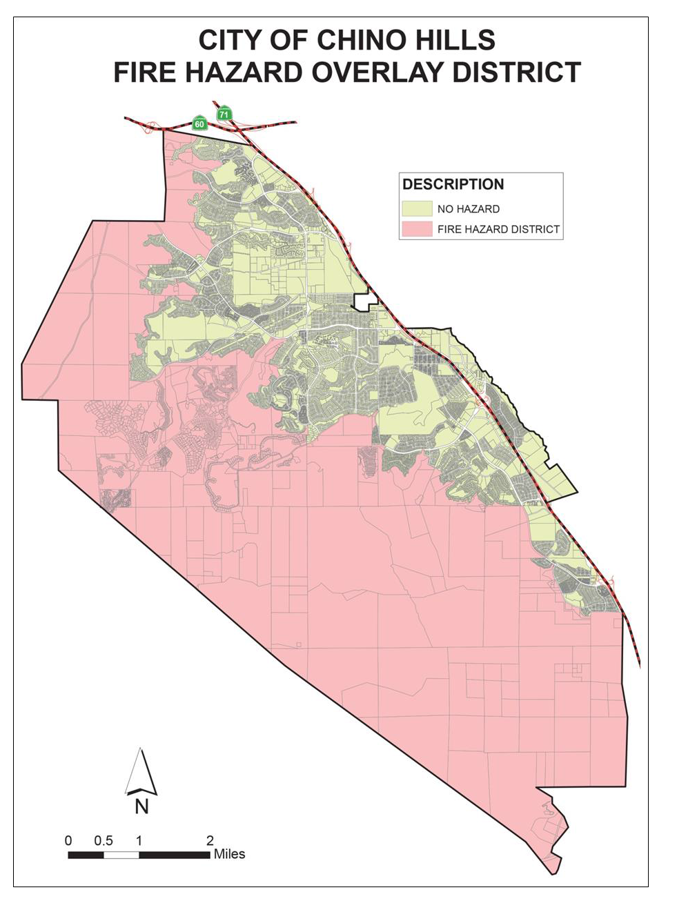
Figure 16.22-1 Fire Hazard Overlay District
(Ord. No. 329, § 5, 6-12-2018)
16.22.030 - Regulations for the Fire Hazard Overlay District.
A.
Construction Requirements.
1.
All construction shall comply with the requirements of Section 7A of the Building Code.
B.
Building Separations Standards.
a.
Structures on separate lots shall have exterior wall separations from any structure on an adjoining lot of at least thirty (30) feet. This separation shall be clear to sky with no roof or overhang obstructing the separation. Alternate measures that achieve the same level of protection as a thirty (30) foot separation may be substituted in lieu of the thirty (30) foot separation, subject to approval by the Chino Valley Fire District and the Community Development Director. For the purposes of this section, structure is "a walled or covered building that is principally above ground and subject to a building permit."
(Ord. No. 329, § 5, 6-12-2018)
16.22.040 - Regulations for the fuel modification areas.
A.
A permanent fuel modification area is required around development projects or portions of such projects for the purpose of fire protection. The required width of the fuel modification area shall be determined by the Chino Valley Fire District as deemed necessary to mitigate fire hazards, but in no case shall it be less than one hundred (100) feet in width as measured from the development perimeter. The width of the fuel modification area shall be determined based upon:
1.
The natural ungraded slope of the land within the project and in the areas adjacent to the project;
2.
Fuel loading;
3.
Access to the project and access directly to the fuel-modified area;
4.
The on-site availability of water that can be used for firefighting purposes.
B.
Adequate provisions shall be made for the continual maintenance of such areas, and such areas shall be designated as common open space rather than private open space.
C.
Fuel modification areas shall also incorporate soil erosion and sediment control measures to alleviate permanent scarring and accelerated erosion.
D.
When development projects are phased, required fuel modification areas shall be in place prior to the first certificate of occupancy.
E.
Perimeter Access to Fuel Modification Area.
1.
Development projects shall provide for adequate vehicular access for firefighting vehicles to the development perimeter of the project along the portion of the development perimeter that is adjacent to either an existing or proposed fuel-modification area. The development shall provide for the continual maintenance of the areas intended to provide such access ensuring that the access ways are unobstructed and maintained in good condition. Perimeter access shall be provided through one of the following two measures unless otherwise approved by the Chino Valley Fire District:
a.
The provision of an existing or proposed road along the development perimeter, or portion thereof that is exposed to a wildland urban interface, open space or fuel-modified area, and which is accessible to firefighting equipment. Such a road shall be paved with all-weather material and capable of supporting firefighting equipment, shall be at least twenty (20) feet in width and shall not exceed a grade of twelve (12) percent unless otherwise approved by the Chino Valley Fire District.
b.
Development projects shall provide access ways, at least twelve (12) feet in width, with grade not to exceed twelve (12) percent, and capable of supporting firefighting vehicles, between the development perimeter and proposed or existing streets. Access ways shall be spaced at intervals of no more than an average of three hundred fifty (350) feet along each street.
(Ord. No. 329, § 5, 6-12-2018)