
Cincinnati City Zoning Code
CHAPTER 1400
GENERAL PROVISIONS AND RULES FOR MEASUREMENT
§ 1400-01.- Title.
This Title XIV of the Municipal Code is known and may be cited as the Cincinnati Zoning Code.
(Ordained by Ord. No. 15-2004, eff. Feb. 13, 2004)
§ 1400-03. - Purposes.
The Cincinnati Zoning Code is adopted to:
(a)
Provide a guide for the physical development of the city.
(b)
Preserve the character and quality of residential neighborhoods.
(c)
Foster convenient, harmonious and workable relationships among land uses.
(d)
Achieve the arrangement of land uses described in the comprehensive plan for the development of the City as may have been adopted by Council.
(e)
Promote the economic stability of existing land uses and protect them from intrusions by inharmonious or harmful land uses.
(f)
Provide opportunities for economic development and new housing for all segments of the community.
(g)
Create pedestrian-friendly environments to reduce reliance on the automobile for travel.
(h)
Prevent excessive population densities and overcrowding of land or buildings.
(i)
Ensure the provision of adequate open space for light, air and fire safety.
(j)
Ensure that development is compatible with the environment, particularly on the hillsides and along the riverfront.
(k)
Promote the conservation, protection, restoration and enhancement of the historic resources of the city.
(l)
Lessen congestion in the public streets by providing for off-street parking and loading areas for commercial vehicles.
(m)
Provide effective signage that is compatible with the surrounding urban environment.
(n)
Set standards by which a nonconforming use may continue to function and to provide for the adaptive reuse of nonconforming buildings.
(o)
Define the powers and duties of the administrative officers, hearing officers and the Zoning Board of Appeals.
(p)
Provide penalties for violations of the provisions of the Cincinnati Zoning Code.
(Ordained by Ord. No. 15-2004, eff. Feb. 13, 2004)
§ 1400-05. - Applicability.
All development must comply with the standards, criteria and procedures of the Cincinnati Zoning Code. Development may not be undertaken without prior authorization pursuant to the Cincinnati Zoning Code.
(a)
Applicability to Property. The Cincinnati Zoning Code applies to all land within the City of Cincinnati, including land owned by the City of Cincinnati and other local, state, or federal agencies to the extent allowed by law. Application of regulations to specific lots is governed by the zoning map.
(b)
Compliance with Regulations. Land may not be used, and structures may not be constructed, occupied, enlarged, altered, demolished or moved, except in accord with the provisions of the Cincinnati Zoning Code.
(c)
Public Nuisance. Neither the provisions of this Chapter nor the approval of any permit authorized by the Cincinnati Zoning Code authorizes the maintenance of any public nuisance.
(d)
Conflict with Other Regulations. Where conflict occurs between the provisions of the Cincinnati Zoning Code and any other City code, chapter, resolution, guideline or regulation, the more restrictive provision controls, unless otherwise specified in this Chapter.
(e)
Extension of Time for Holidays and Weekends. If a deadline falls on a weekend or holiday, the time for performing an act is extended to the next working day.
(Ordained by Ord. No. 15-2004, eff. Feb. 13, 2004)
§ 1400-07. - Zoning Designation System.
Land use and development regulations applicable to specific sites are shown on the Zoning Map by zoning designations consisting of classes of letter designators:
(a)
Land Use Regulations Designator. This designator indicates the principal land uses permitted or conditionally permitted in each district and is a component of all zoning designations, for example, SF Single-family Residential District, RM Residential Multi-family District or CN Commercial Neighborhood District.
(b)
Residential Density Designator. This designator indicates a subdistrict with a specific range of dwelling unit densities as a component of certain residential zoning designations, for example, SF-20 Single-family Residential District is the lowest density range, which requires 20,000 square feet for every dwelling unit. RM-2.0 requires 2,000 square feet for every dwelling unit.
(c)
Subarea Designation. Within the DD Downtown Development District, subdistricts are designated by letters (A, B, C or D) following the zoning district designation. Similarly, in the commercial districts, subarea designations are used for Pedestrian (P), Mixed (M), and Automobile Oriented (A).
(d)
Special Review District Designators. These designators are included in a zoning designation if the provisions of one or more districts are applicable to a site or area. For example, HS indicates that the property is within a Hillside District.
(Ordained by Ord. No. 15-2004, eff. Feb. 13, 2004)
§ 1400-09. - Interpretation.
The provisions of the Cincinnati Zoning Code are the minimum requirements, adopted for the promotion of the public health, safety, convenience, comfort, prosperity and general welfare. Where the Cincinnati Zoning Code imposes a greater restriction on the use of buildings or premises or on the heights of buildings, or requires larger setbacks, lot area for every dwelling unit, or other open spaces, or requires more parking and loading space or is in any way more restrictive than other provisions of law or ordinance, the provisions of the Cincinnati Zoning Code control.
(Ordained by Ord. No. 15-2004, eff. Feb. 13, 2004)
§ 1400-11. - Establishment of Zoning Districts.
For the purposes of the Cincinnati Zoning Code, the City of Cincinnati is divided into 24 zoning districts. These zoning districts are intended to:
(a)
Location and Use. Regulate and restrict the location and use of buildings and land for residence, commerce and trade, industry, transportation, communications and utilities and other purposes.
(b)
Dimensions. To regulate and restrict the height and size of buildings and structures hereafter erected or structurally altered, the size of yards, setbacks, other open spaces and the density of population.
(c)
Standards. To establish site development and design standards, subdivision standards and requirements for adequate public facilities and services.
Base zoning districts and chapter references are shown in Schedule 1400-11. References to classes of districts (SF, RM, C, UM, DD, M, RF, PR and IR) include all of the subdistricts.
Schedule 1400-11: Establishment of Zoning Districts
(Ordained by Ord. No. 15-2004, eff. Feb. 13, 2004; a. Ord. No. 0221-2007, § 1, eff. July 6, 2007; a. Ord. No. 0060-2008, § 1, eff. March 13, 2008; a. Ord. No. 257-2007, § 1, eff. Aug. 27, 2007)
§ 1400-13. - Establishment of Special Review Districts.
§ 1400-15. - District Hierarchy.
The term "more restrictive" district applies to any district in the sequence set forth in Schedule 1400-15 that precedes any other district in Schedule 1400-15 and the term "less restrictive" applies to any district which succeeds any other district in Schedule 1400-15.
Schedule 1400-15: District Hierarchy
(a)
Single-family (SF-20)
(b)
Single-family (SF-10)
(c)
Single-family (SF-6)
(d)
Single-family (SF-4)
(e)
Single-family (SF-2)
(f)
Manufacturing Agricultural (MA)
(g)
Residential Mixed (RMX)
(h)
Residential Multi-family (RM-2.0)
(i)
Residential Multi-family (RM-1.2)
(j)
Residential Multi-family (RM-0.7)
(k)
Riverfront Residential/Recreational (RF-R)
(l)
Office Limited (OL)
(m)
Office General (OG)
(n)
Institutional-Residential (IR)
(o)
Commercial Neighborhood-Pedestrian (CN-P)
(p)
Commercial Community-Pedestrian (CC-P)
(q)
Commercial Neighborhood-Mixed (CN-M)
(r)
Downtown Development (DD)
(s)
Commercial Community-Mixed (CC-M)
(t)
Commercial Community-Auto Oriented (CC-A)
(u)
Urban Mixed (UM)
(v)
Manufacturing Limited (ML)
(w)
Commercial General-Auto Oriented (CG-A)
(x)
Manufacturing Exclusive (ME)
(y)
Riverfront Commercial (RF-C)
(z)
Riverfront Manufacturing (RF-M)
(aa)
Manufacturing General (MG)
(Ordained by Ord. No. 15-2004, eff. Feb. 13, 2004; a. Ord. No. 0221-2007, § 2, eff. July 6, 2007; a. Ord. No. 0060-2008, § 2, eff. March 13, 2008)
§ 1400-17. - Zoning Map.
The boundaries of these districts are established as shown on the Zoning Map that accompanies and is a part of the Cincinnati Zoning Code.
(Ordained by Ord. No. 15-2004, eff. Feb. 13, 2004)
§ 1400-19. - Declaration of Unconstitutionality.
Whenever a court declares, by a judgment or decree that is final and further appeal is no longer available, that the zoning of property is unconstitutional or otherwise invalid, the property affected is thereupon subject to the restrictions applicable to the next less restrictive district. Provided however, if the court, in such judgment or decree, declares that the property may be used for a particular use or uses because the City has no right to prohibit such use or uses on the property, then the property shall be subject to the restrictions applicable to the most restrictive district in which the particular use or uses declared proper by the court are permitted. The zoning restrictions made applicable to property pursuant to this section remain in effect for a period not to exceed 120 days after the judgment or decree declaring the prior zoning unconstitutional or invalid becomes final. The purpose of this section is to prevent property from being unzoned from the time the zoning thereof is held unconstitutional or invalid until rezoned by Council.
(Ordained by Ord. No. 15-2004, eff. Feb. 13, 2004)
§ 1400-21. - Interpretation of District Boundaries.
Where uncertainty exists regarding the boundary of a zoning district, the following rules apply:
(a)
Property Lines. District boundaries shown as approximately following the property line of a lot are construed to follow such property line.
(b)
Scale. On unsubdivided land or where a district boundary divides a lot, the location of the district boundary is determined by using the scale appearing on the zoning map, unless the boundary location is indicated by dimensions printed on the map.
(c)
Boundary Lines. District boundaries shown as approximately following right-of-way lines of freeways, streets, railroads, streams, corporations or other identifiable boundary lines are construed to follow such right-of-way or boundary lines.
(d)
Centerlines. District boundaries shown as lying within right-of-way lines of freeways, streets, railroads, streams, corporations or other identifiable boundary lines are construed to follow the centerline of such right-of-way or boundary lines.
(e)
Uncertainty. If any uncertainty remains as to the location of a district boundary or other feature shown on the zoning map, the Director of City Planning has the duty to determine the location.
The Director of City Planning has the duty to keep a record of interpretations made pursuant to this section and keep them available to the public.
(Ordained by Ord. No. 15-2004, eff. Feb. 13, 2004; Emer. Ord. No. 141-2015, § 1, eff. July 1, 2015)
§ 1400-23. - Principal Structures.
No more than one principal structure may be constructed on a lot unless the development of more than one structure has been approved pursuant to §1419-12, Community Learning Centers or Chapter 1429, Planned Development Districts.
(Ordained by Ord. No. 15-2004, eff. Feb. 13, 2004; a. Ord. No. 127-2018, § 1, eff. July 6, 2018; a. Emer. Ord. No. 199-2024, § 2, eff. 7-1-2024)
§ 1400-25. - Lots Divided by District Boundaries.
Where a district boundary divides a lot in single ownership and of record prior to and continuously since the time the district boundary line was established, the use authorized on and the district requirements of the least restricted portion of the lot are construed as extending to the entire lot; provided that the extension may not include any part of the lot that is more than 25 feet from that district boundary.
(Ordained by Ord. No. 15-2004, eff. Feb. 13, 2004)
§ 1400-27. - Measurements.
The sections that follow explain how various measurements referenced in the Cincinnati Zoning Code are to be calculated.
(Ordained by Ord. No. 15-2004, eff. Feb. 13, 2004)
§ 1400-27-D. - Distances.
Distances are measured as follows:
(a)
Distances Are Measured Horizontally. When determining distances for setbacks and structure dimensions, all distances are measured along a horizontal plane from the appropriate line, edge of building, structure, storage area, parking area or other object. These distances are not measured by following the topography of the land.
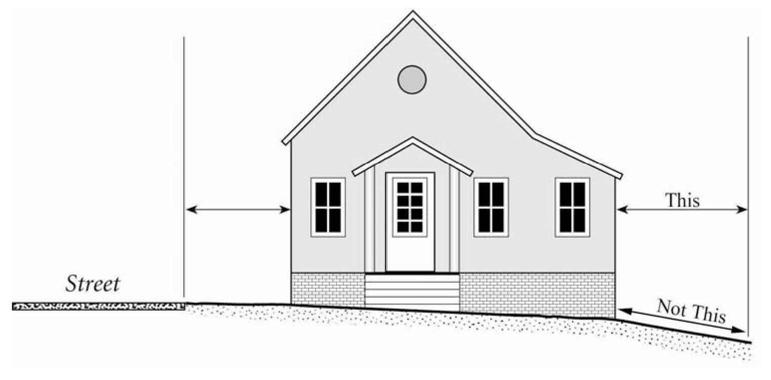
FIGURE 1400-27-D-A Measuring Distances Horizontally
(b)
Measurements are Shortest Distance. When measuring a required distance, such as the minimum distance between a structure and a lot line, the measurement is made at the closest or shortest distance between the two objects. Exceptions are stated in Subsections (c), (d) and (e) below.
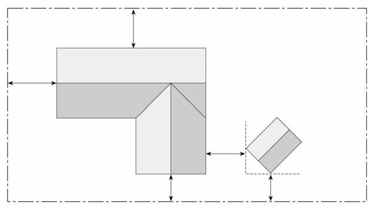
FIGURE 1400-27-D-B Measuring Shortest Distance
(c)
Measurement of Vehicle Stacking or Travel Areas. Measurement of a minimum travel distance for vehicles, such as garage entrance setbacks and stacking lane distances, is measured down the center of the vehicle travel area. For example, curving driveways and travel lanes are measured along the arc of the driveway or traffic lane.
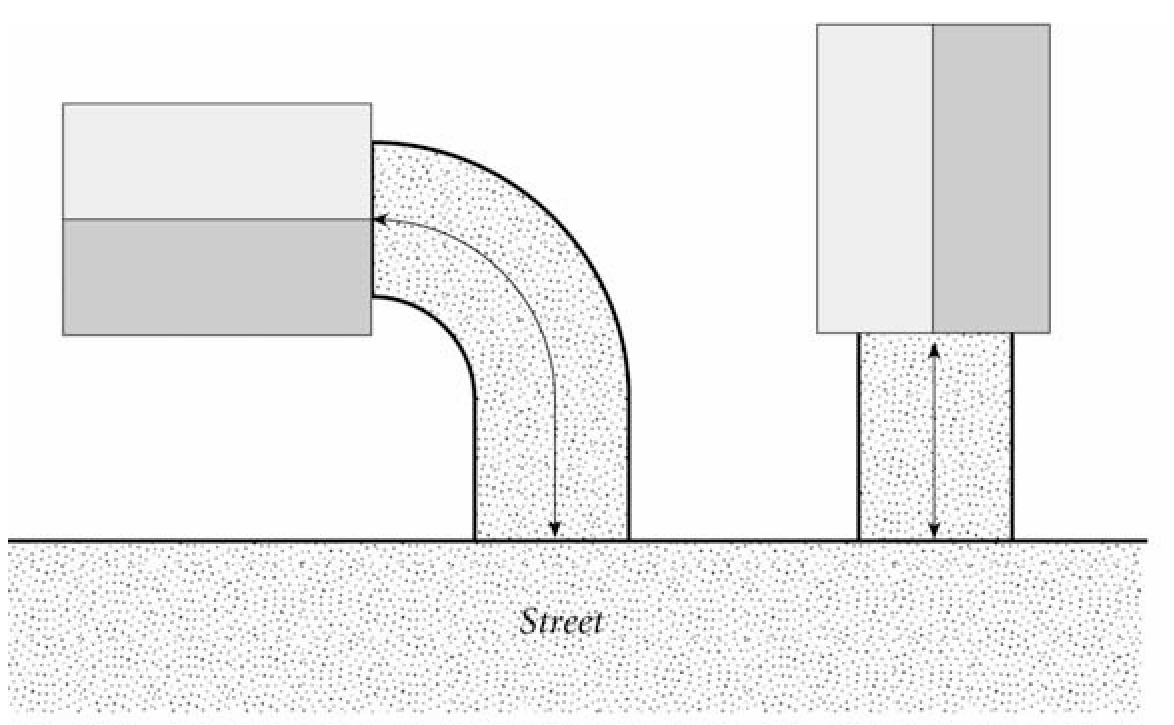
FIGURE 1400-27-D-C Measuring Vehicle Stacking or Travel Areas
(d)
Measurements Involving a Structure. Measurements involving a structure are made to the closest wall of the structure. Chimneys, eaves and bay windows up to 12 feet in length, are not included in the measurement. Other features, such as covered porches and entrances, are included in the measurement.
(e)
Underground Structures. Structures or portions of structures that are entirely underground are not included in measuring required distances.
(Ordained by Ord. No. 15-2004, eff. Feb. 13, 2004)
§ 1400-27-F. - Determining Floor Area Ratio.
The floor area ratio is measured as the proportion of allowable building gross floor area divided by the area of the parcel of land on which the building rests. For purposes of calculating the floor area ratio, gross floor area associated with the following is excluded:
(a)
Attic space having a headroom of seven feet or less.
(b)
Space devoted exclusively to parking and loading within the building.
(c)
Utility or furnace rooms.
(d)
Space used for incidental service storage.
(e)
Space used for the installation of mechanical equipment, ventilators, heating systems and similar uses.
(f)
Space for the common recreational use of tenants and guests that is not part of a dwelling unit.
(Ordained by Ord. No. 15-2004, eff. Feb. 13, 2004; a. Ord. No. 0346-2007, § 1, eff. Oct. 13, 2007)
§ 1400-27-F-1. - Fractions.
When calculations result in fractions the results are rounded as follows:
(a)
Minimum Requirements. When a regulation is expressed in terms of a minimum requirement, any fractional result over 0.5 is rounded up to the next consecutive whole number.
(b)
Maximum Limits. When a regulation is expressed in terms of maximum limits, any fractional result will be rounded down to the next lower whole number. For example, if a maximum limit of one dwelling unit for every 20,000 square feet in the SF-20 district is applied to a 50,000 square foot site, the resulting fraction of 2.5 is rounded down to two allowed dwelling units.
(Ordained by Ord. No. 15-2004, eff. Feb. 13, 2004)
§ 1400-27-H. - Height.
Height is measured as follows:
(a)
Measuring Building Height. Building height is measured from the established grade in the front of the lot or from the average natural grade at the building line, if higher to the top of the cornice of flat roofs, or to the deck line of a mansard roof, or to the mid-height of the highest gable or dormer in a pitched or hipped roof, or, if there are no gables or dormers, to the mid-height of a pitched or hipped roof.
(b)
Measuring Height of Other Structures. The height of other structures such as fences is the vertical distance from the ground level immediately under the structure to the top of a structure. Special measurement provisions are also provided below.
(c)
Measuring Height of Fences on Top of Retaining Walls. Fences on the top of retaining walls are measured from the top of the retaining wall.
(d)
Measuring Height of Decks. Deck height is determined by measuring from the ground to the top of the floor of the deck if there is no rail and from the average finished grade to the top of the rails for all other situations.
(Ordained by Ord. No. 15-2004, eff. Feb. 13, 2004)
§ 1400-27-L. - Lot Width.
The horizontal distance between the side lot lines as measured from the midpoint of one side lot line to the midpoint of the other side lot line.
(Ordained by Ord. No. 15-2004, eff. Feb. 13, 2004)
§ 1400-27-S. - Minimum Separation Distance.
In cases where a minimum separation distance applies, the minimum distance is measured in a straight line, without regard to intervening structures, from the closest property line of the use being regulated to the closest property line, district boundary line or use from which the minimum distance is required.
(Ordained by Ord. No. 15-2004, eff. Feb. 13, 2004)
§ 1400-27-S1. - Setback Averaging.
Certain regulations allow for setbacks to be averaged. In these situations, the required setback may be reduced to the average of the existing setbacks of the lots that are on both sides of the site. The following rules apply in calculating the average setback:
(a)
Abutting Setbacks. Only the setbacks on the lots that abut each side of the site and are on the same street may be used. Setbacks across the street or along a different street may not be used.
(b)
Vacant Abutting Lots and Corner Lots. When one abutting lot is vacant, the average is of the setback of the abutting non-vacant lot and the required setback for the vacant lot. When the subject lot is a corner lot, the average is of the setback of the abutting non-vacant lot and the required setback of the subject lot.
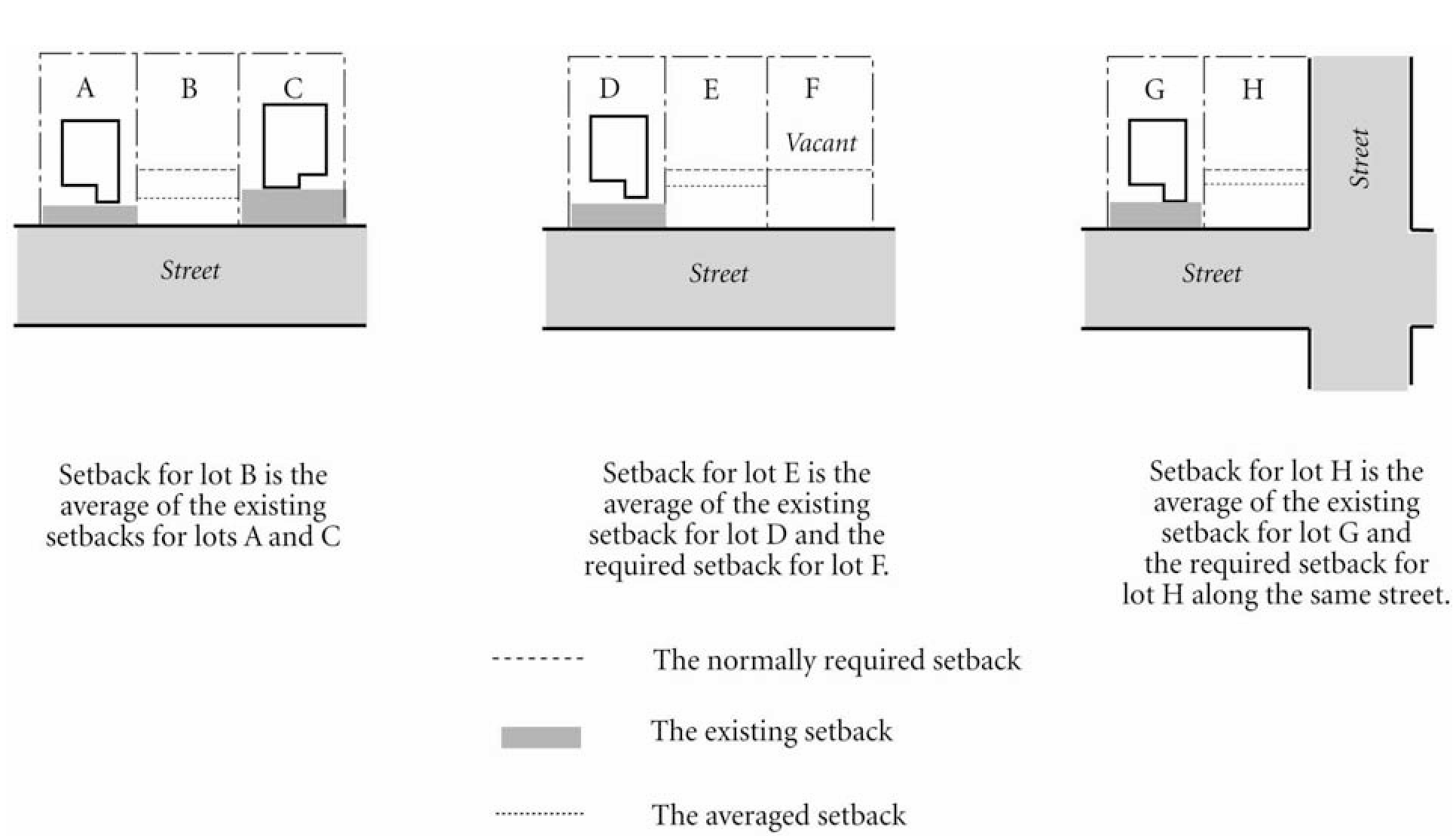
FIGURE 1400-27-S1 Examples of Front Yard Averaging
§ 1400-27-S2. - Square Footage, Multiple Uses by Single Entity.
When determining total square footage, an establishment with multiple uses/products operating under one roof, on the same building footprint and controlled by a unifying entity shall have the square footage devoted to each separate use/product category combined and measured for a total square foot calculation.
(Ordained by Ord. No. 376-2006, § 1, eff. Jan. 20, 2007)