
Decatur City Zoning Code
ARTICLE 12
- Definitions
12.1.1. - Generally
For the purpose of this UDO, certain terms and words are hereby defined. Words used in the present tense shall include the future; the singular number shall include the plural and the plural the singular; the word "building" shall include the word "structure" and the word "shall" is mandatory and not directory. Any words not herein defined shall be construed as defined in the general City Code and where definitions in the general City Code are in conflict with those herein, the definitions herein shall prevail.
The following words, terms and phrases, when used in this chapter, shall have the meanings ascribed to them in this Section, except where the context clearly indicates a different meaning.
A
Accessory buildings and uses. A subordinate building or a portion of the main building, the use of which is incidental to that of the main use of the premises.
Accessory dwelling unit. See Section 6.8.3.A.
Accessory sign. A separate unit displaying information related to the principal business conducted on the premises, which is attached to or supported from any other sign and not made a part thereof.
Addition (to an existing building). Any walled and roofed expansion to the perimeter of a building in which the addition is connected by a common load-bearing wall other than a fire wall. Any walled and roofed addition which is connected by a fire wall or is separated by an independent perimeter load-bearing wall shall be considered new construction.
Administrative standards. A set of standards for administering the tree ordinance that are a part of the tree ordinance by reference.
Administrator, UDO. The City Manager or the City Manager's designee.
Administrator, Zoning. The City Manager or the City Manager's designee.
Adult day care center. A facility, whether operated for profit or not, that undertakes through its ownership or management to provide for less than 24 hours per day, basic adult day care or adult day health services to three or more adults, not related by blood or marriage, who require basic services. Includes any establishment that regularly provides adult custodial services.
Adult entertainment. Any performance, act, show or contest, either live or electronically reproduced, where any person appears unclothed or in such attire, costume or clothing as to expose to view any portion of the female breast below the top of the areola, or any portion of a person's pubic hair, anus, cleft of buttocks, vulva or genitals.
Adult entertainment establishment. A business or establishment where employees or patrons expose specified anatomical areas or engage in specified sexual activities including, but not limited to: adult bookstores, adult businesses, adult motion picture theaters, adult mini-motion picture theaters, adult motion picture arcades, adult video stores, erotic entertainment/dance establishments, escort bureaus, and introduction services. Advertising structure. Any structure or device erected for the purpose of supporting any sign or other advertising or informational media and the framework of the sign.
Affordable Housing Provider. A non-profit organization, which is exempt from federal income tax under the Internal Revenue Code of 1986 or a directly funded agency of a unit of government having a mission to develop and/or protect affordable or workforce housing, including inclusionary dwelling units.
A-frame sign. Any double-faced sign having a metal or wooden frame adequately braced so as to be freestanding on but not permanently attached to the ground.
Agricultural. See Section 6.7.1.
Alley. A public or private way which affords only a secondary means of access to property abutting thereon.
Alternative telecommunication tower structure. Artificial trees, clock towers, bell steeples, light poles and similar alternative-design mounting structures, that are compatible with the natural setting and surrounding structures, and effectively camouflage or conceal the presence of antennas or towers.
Amenity space. See Section 2.1.3.
Animal care. A facility designed or arranged for the care of animals without any outdoor activity. No out-door activity associated with care of animals is allowed. Includes animal grooming, animal hospital, veterinary clinic, pet clinic, animal boarding, animal shelter, cattery, commercial kennel (11 or more dogs) and doggy day care. Includes veterinary hospital, clinic, kennel, animal grooming and doggy day care.
Animated sign. Any sign with action or motion with moving characters or changing colors which requires electrical energy, but not including wind actuated elements such as flags or banners. This definition includes electronic signs with lights and other elements which change copy and other characters.
ANSI. American National Standards Institute; organization that publishes national standards for tree care maintenance operations, safety standards, and nursery stock.
Antenna. See Telecommunications Antenna.
Apartment house. See dwelling, multiple.
Appeal. A request for a review of the UDO Administrator's interpretation of or final action on any provision of this UDO, or other administrative or court reviews authorized by this UDO.
Applicant. A person submitting a land development application and plan for approval.
Applicable codes. Applicable codes are as follows:
1) Any optional housing or abatement standard provided in Chapter 2 of Title 8 of the Official Code of Georgia Annotated ("O.C.G.A.") as adopted by ordinance or operation of law, or general nuisance law, relative to the safe use of real property;
2) Any fire or life safety code as provided for in Chapter 2 of Title 25 of O.C.G.A.; and
3) Any building codes adopted by local ordinance prior to October 1, 1991, or the minimum standard codes provided in Chapter 2 of Title 8 of O.C.G.A. after October 1, 1991, provided that such building or minimum standard codes for real property improvements shall be deemed to mean those building or minimum standard codes in existence at the time such real property improvements were constructed unless otherwise provided by law.
Arboricultural prescription. Any type of mitigation or treatment plan developed by a certified arborist or registered forester to provide for conserving tree(s). It is required for trees with a critical root zone impact of at least 20% but less than 25%.
Area of shallow flooding. A designated AO or AH zone on a community's flood insurance rate map (FIRM) with base flood depths from one to three feet, and/or where a clearly defined channel does not exist, where the path of flooding is unpredictable and indeterminate, and where velocity flow may be evident.
Area of special flood hazard. The land subject to a one percent or greater chance of flooding in any given year. This includes all floodplain and flood-prone areas at or below the base flood elevation (including A, A1-30, A-99, AE, AO, AH, and AR on the FHBM or the FIRM), all floodplain and flood-prone areas at or below the future-conditions flood elevation, and all other flood-prone areas as referenced in Section 9.5.3.D. All streams with a drainage area of 100 acres or greater shall have the area of special flood hazard delineated.
Art gallery, public. A public facility where works of art are displayed on a regular basis.
Assisted living facility. A personal care home as defined in this Article, but having 25 or more beds and which offers a range of accommodations from independent residential housing options to housing options with personal services. A residential use, which could otherwise be classified as multifamily, is to be considered an assisted living facility if it is registered with or licensed by the State of Georgia as an assisted living home. Any facility licensed by the State of Georgia as a facility offering a contract to provide an individual of retirement status, other than an individual related by consanguinity or affinity to the provider furnishing the care, with board and lodging, licensed nursing facility care and medical or other health related services is a subtype of assisted living facility to be described as a Continuing Care Retirement Community (CCRC). The inclusion of skilled nursing care in a CCRC under a certificate of need issued by the State of Georgia shall be considered part of the assisted living facility and shall not be deemed to be a separate use. Any dwelling, facility or structure which for any reason is not required to be licensed by the State of Georgia as an assisted living home, or fails to be licensed by or registered with the State of Georgia as an assisted living home but, which through its ownership or management undertakes for a fee or accepts a grant or utilizes its own funding to provide or arrange for the provision of housing, food service, and one or more personal services for any person and which also provides beds for 25 or more persons, who are not related to the owner or administrator by blood, marriage or adoption, shall also be considered an assisted living facility for the purpose of this definition. This definition shall apply without regard to whether any fee charged is paid by the individual to whom the services are provided or by another person, the source of the grant, or the funding source for the operational costs and without regard to whether the facility is operated for profit or not for profit. Personal services include, but are not limited to, individual assistance with or supervision of self-administered medication, and essential activities of daily living such as bathing, grooming, dressing and toileting. For the purposes of this ordinance, a "child caring institution" or "group-care facility" as defined in O.C.G.A. § 49-5-3, as amended, with 25 or more beds shall also be considered an assisted living facility.
Awning. Any structure made of cloth or metal with a metal frame attached to a building and projecting over a thoroughfare, when the same is so erected as to permit its being raised to a position flat against the building when not in use, as opposed to a canopy.
Awning sign. Any sign attached to, affixed to, or hung from an awning.
B
Banner. A temporary sign made of cloth, paper, plastic or similar material, but not cut into ribbons, streamers, strips or pennants.
Base flood. The flood having a one percent chance of being equaled or exceeded in any given year, also known as the 100-year flood.
Base flood elevation. The highest water surface elevation anticipated at any given point during the base flood.
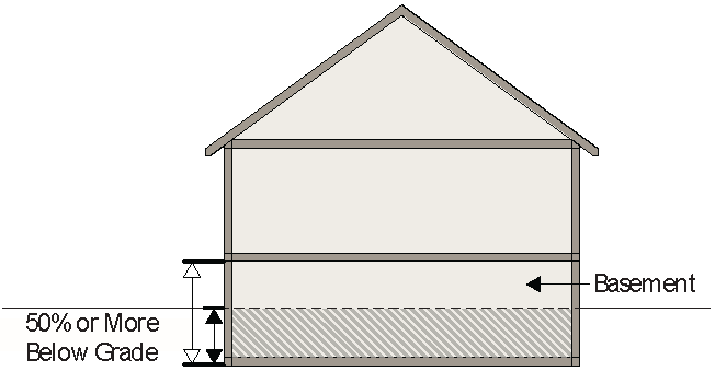
Basement. That portion of a building having 50 percent or more of its exterior wall height below grade. A basement is not counted as a story for the purpose of height regulation. The entire wall area of each basement wall will be calculated and 50 percent or more of the cumulative area must be below grade.
Bathroom. A room having the following minimum facilities:
1) Water Closet (Toilet)
2) Lavatory
3) Bathtub or Shower
Bed and breakfast. An owner occupied single-family dwelling where, for compensation, overnight lodging or overnight lodging and a breakfast meal is provided to guests, pursuant to a permit issued in accordance with applicable State law. No more than three guest rooms may be rented per night and no guest may lodge for more than 14 consecutive nights.
Best Management Practices (BMPs):
1) Stormwater Management (Section 9.3)—Both structural devices to store or treat stormwater runoff and non-structural programs or practices which are designed to prevent or reduce the pollution of the waters of the State of Georgia.
2) Soil Erosion and Sedimentation Control (Section 9.4)—Sound conservation and engineering practices to prevent and minimize erosion and resultant sedimentation, which are consistent with, and no less stringent than, those practices contained in the Manual for Erosion and Sediment Control in Georgia published by the commission as of January 1 of the year in which the land-disturbing activity was permitted.
BMP landscaping plan. A design for vegetation and landscaping that is critical to the performance and function of the BMP including how the BMP will be stabilized and established with vegetation. It shall include a layout of plants and plant names (local and scientific).
Billboard. Any off-site or off-premises board, fence, sign or structure not located on the premises of the business or entity indicated or advertised by such sign which is erected for advertising purposes or upon which any advertisement is shown, or whereupon any poster, bill, printing, painting, device or other advertising matter of any kind may be placed, stuck, tacked, posted, printed, painted, pasted or fastened. This definition shall not be held to include any board sign or surface used to display official notices issued by any court or public officer, or posted by any public officer in the performance of a public duty.
Block. A piece or parcel of land entirely surrounded by public highways or streets (or private streets built to public standards), other than alleys. In cases where the platting is incomplete or disconnected, the UDO Administrator may determine the outline of the block.
Boardinghouse. A dwelling other than a hotel where, for compensation and by prearrangement for a definite period, meals or lodging and meals are provided for three or more persons.
Boat. A vessel or craft designed or constructed for use on the water, usually moved by sail, oars, paddles or motive-type power.
Boat trailer. A portable-type structure designed or constructed for the purpose of transporting a boat upon the highways or City streets and which may be used as a storage platform for such boat when it is not in use.
Boundary tree. A tree growing on a property boundary line between 2 lots resulting in joint ownership by the adjacent property owners when the trunk exists on each property, or a tree that has 20% or more of its critical root zone extending across a property boundary and into an adjacent property applying for a land disturbance permit.
Buffer, stream. The area of land immediately adjacent to the banks of state waters in its natural state of vegetation, which facilitates the protection of water quality and aquatic habitat as defined in Section 9.2.
Buffer or buffer area. An area or portion of a lot set aside for open space and visual screening purposes, to separate different zoning districts or to separate uses on one property from uses on another property of the same zoning district or a different zoning district.
Building. Any structure having a roof supported by columns or walls designed or built for the support, enclosure, shelter or protection of persons, animals, chattel or property of any kind.
Building codes. Any of the building, electrical, and similar construction codes adopted for use within the City.
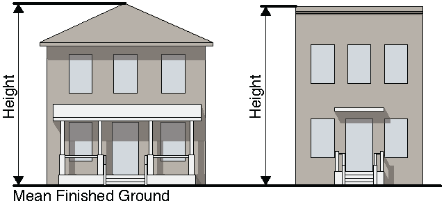
Building, height of. The vertical distance from the mean finished ground level at the front of the building to the highest point of a roof.
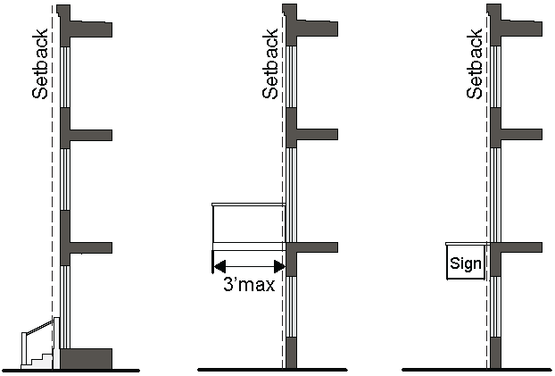
Building line. A line established by yard or setback requirements in district regulations between which and the street line no building or part thereof may be erected except as may be provided in the regulations.
Building setback line. The minimum horizontal distance between the street right-of-way line or the street centerline where appropriate and the building or any projection thereof except:
1) Steps, terraces and open fire escapes.
2) Balconies, canopies or cornices project not more than three feet beyond the main building wall.
3) Offset or overlapping portions of the second floor of the building that do not extend more than three feet beyond the main wall of the building.
4) Signs.
Bulletin board. Any sign which primarily displays the name of an organization and the upcoming events of that organization.
Business identification sign. Any sign which directs attention to a business, profession, product, service, activity or entertainment conducted, sold or offered on the premises upon which the sign is located.
Business occupancy buildings. All medical, dental and general offices, courthouses, outpatient clinics, town and city halls, college and university instructional buildings (including classrooms for less than 50 persons and instructional laboratories), and similar buildings.
Business or professional office. Including, but not limited to, lawyer, accountant, auditor, bookkeeper, engineer, architect, sales office, travel agency, interior decorator or security system sales.
C
Caliper. The diameter of the trunk of nursery stock measured in inches at six inches above the ground for up to and including four inch caliper size, and 12 inches above the ground for larger sizes.
Call center. A facility used for the purpose of receiving or transmitting a large volume of telephone calls.
Canopy. Any structure made of cloth or metal with a metal frame attached to a building and erected so as to permanently project over a thoroughfare, as opposed to an awning.
Canopy loss fee. A fee that estimates the benefits lost to the community by removal of a tree. The fee is based on the amount of yearly benefit lost per tree removed.
Canopy sign. Any sign attached to, affixed to, or hung from a canopy.
Canopy tree. A large or medium tree with a crown size and shape that will typically provide at maturity significant shade, substantial environmental services, and measurable benefits on temperature, air quality, water quality, and other environmental conditions; sometimes referred to as a shade tree.
Carport. A roofed structure for the storage of vehicles with no more than two walls.
Cellar. That portion of a building between floor and ceiling which is wholly below grade or having more than ½ of its height below grade. A cellar is not counted as a story for the purpose of height regulation.
Cemetery. The use of property as a burial place.
Certificate of Appropriateness. A document evidencing approval by the historic preservation commission of an application to make a material change in the appearance of a designated historic property or of a property located within a designated historic district.
Certificate of Exemption. A document evidencing approval by the historic preservation commission or its authorized designee of an application to make a change other than a material change as defined by the design guidelines adopted as part of the ordinance designating the specific local historic property or local historic district.
Certified Arborist. An arborist certified by the International Society of Arboriculture as possessing a minimum level of competency required to practice arboriculture.
Certified Personnel. A person who has successfully completed the appropriate certification course approved by the Georgia Soil and Water Conservation Commission.
Changeable Copy Panel. A sign or sign device consisting of or incorporating a panel designed specifically to allow the frequent changing of the copy thereon.
Channel. A natural or artificial watercourse with a definite bed and banks that conducts continuously or periodically flowing water.
City Arborist. An individual authorized by the City Manager to act as the City Arborist; to advise the City on the administration of the tree ordinance; to advise the City in the management of public trees; and, to develop and implement programs for community forest management.
City. The City of Decatur.
City Engineer. The City Engineer of the City or the City Engineer's designee.
Civic. See Section 6.4.1.
Clean Water Act. The Federal Water Pollution Control Act (33 U.S.C. § 1251 et seq.), and any subsequent amendments thereto.
Cleaning establishment. Including carpet cleaning service, dry-cleaning or laundry drop-off, laundromat, washeteria.
Clinic. A clinic is an establishment where patients, who are not lodged overnight, are admitted for examination and treatment by a group of physicians or dentists practicing together.
Clock Sign. Any timepiece erected outside of any building for the purpose of advertising the business on the premises on which it is located.
Closing. Causing a dwelling, building, or structure to be vacated and secured against unauthorized entry.
Club, private. Buildings and facilities owned or operated by a corporation, association, person or persons for a social, educational or recreational purpose, but not primarily for profit or to render a service which is customarily carried on as a business.
Club, lodge. A facility used for associations or organizations of an educational, fraternal or social character, not operated or maintained for profit. Representative organizations include Elks, Veterans of Foreign Wars and Lions.
College, university, seminary. An institution of higher learning that includes seminaries, and related professional offices and businesses.
Co-location of telecommunication antennas. The placement of telecommunication antennas of two or more service providers on the same tower or accessory structure.
Commercial building. Any type of building other than residential.
Commercial message. Any sign, wording, logo, or other visual representation that directly or indirectly names, advertises, or directs attention to a business operated for profit, or to a product, commodity or service for sale or lease, or to any other commercial interest or activity.
Commercial parking. A facility that provides parking as a principal use on the site. A fee may or may not be charged.
Common area or common open area. That land provided for common use and enjoyment of all the residents of a development, provided that such land shall be usable as defined under paragraph 75, total area.
Community garden. An area of land used by two or more individuals for the cultivation of herbs, fruits, flowers, or vegetables, including the cultivation and tillage of soil and the production, cultivation, growing, and harvesting of any agricultural, floricultural or horticultural product for personal use. The area of land may be divided into separate plots, each cultivated individually, or remain as a single plot to be cultivated collectively by a group of individuals.
Comprehensive Plan. The comprehensive land use plan is the official policy of the City, concerning proposed land uses and how land in the City should be used.
Conditional zoning. The granting or adoption of zoning for a property subject to compliance with restrictions as to use, size, design or other conditions required by the City Commission to mitigate impacts which may be expected without the imposition of conditions.
Conservation easement. An agreement between a land owner and the City or other designated government agency or land trust that permanently protects open space or greenspace on the owner's land by limiting the amount and type of development that can take place, but continues to leave the remainder of the fee interest in private ownership.
Construction. The erection of a new building or the alteration of an existing building in connection with its repair or renovation or in connection with making an addition to an existing building, and shall include the replacement of a malfunctioning, unserviceable, or obsolete faucet, showerhead, toilet, or urinal in an existing building.
Construction activity. Activities subject to the Georgia Erosion and Sedimentation Control Act or NPDES General Construction Permits. These include construction projects resulting in land disturbance. Such activities include, but are not limited to, clearing and grubbing, grading, excavating, and demolition. Illicit Discharge means any direct or indirect non-stormwater discharge to the municipal separate storm sewer system, except as exempted in Section 9.6.4.A.
Construction buildings. A manufactured home, travel trailer, truck, trailer or other structure used as an office in conjunction with a construction project.
Construction sign. Any non-illuminated sign located on the property where construction or development is taking place and which identifies contractors, architects, engineers, financial institutions and other parties associated with the construction or development project.
CPESC. A certified professional in erosion and sediment control with current certification by Certified Profession in Erosion and Sediment Control, Inc., a corporation registered in North Carolina, which is also referred to as CPESC or CPESC, Inc.
Craft distillery. A building or group of buildings where distilled spirits are manufactured (distilled, rectified or blended), bottled, packaged, and distributed for wholesale and/or retail distribution, at a rate of production that does not exceed 60,000 gallons annually.
Credits. Credit shall mean a conditional reduction in the amount of a stormwater service fee or other fees, rates, rentals, charges, fines and penalties to an individual property based on the provision and continuing presence of an effectively maintained and operational on-site stormwater system or facility, or continuing provision of a service or activity that reduces the stormwater utility's cost of providing stormwater management systems and facilities.
Critical root zone. The minimum rooting area of a tree necessary to sustain the tree's life, generally defined by the tree's dripline or the area within a radius around the trunk of 1.25 feet for every one inch DBH, whichever is greater, and extending to a depth of three feet below the surface; for a newly planted tree the critical root zone is a minimum six foot radius around the tree.
Crown. The scaffold limbs, branches, twigs, buds and leaves of a tree.
Cul-de-sac. A street having one end open to traffic and being permanently terminated within the plat by a vehicular turnaround.
Curb break. Any interruption, or break, in the line of a street curb in order to connect a driveway to a street, or otherwise to provide vehicular access to abutting property.
Customers of the stormwater utility. Customers of the stormwater utility shall include all persons, properties and entities served by and/or benefiting from the utility's acquisition, management, maintenance, extension, regulation and improvement of the stormwater management programs, systems and facilities and regulation of public and private stormwater systems, facilities and activities related thereto, and persons, properties and entities which will ultimately be served or benefited as a result of the stormwater management program.
Cut. A portion of land surface or area from which earth has been removed or will be removed by excavation; the depth below original ground surface to excavated surface. Also known as excavation.
D
Damage. For the purposes of Section 9.1., harmful injury to a tree or any of its parts, including the roots, trunk, scaffold limbs, branches, twigs, buds or leaves; to cause such injury.
Day care. See Section 6.5.1.
DBH. Diameter at breast height; the diameter in inches of the trunk of an existing tree measured at 4.5 feet above the ground line for single-trunked tree that is not forked below 4.5 feet; measured at the smallest diameter of the trunk below a fork located below 4.5 feet; the diameter of the largest stem of a multi-stemmed tree measured as described above for non-forked and forked trunks.
DDA. The Decatur Downtown Development Authority.
Dead, Diseased or Hazardous Tree (DDH). A tree that is dead, untreatably diseased or infested, has a moderate or higher risk of failure with a target present, or has high to extreme risk of failure that cannot be mitigated.
Demolition. Demolition means the complete removal of structure or a scope of construction (alteration, addition, renovation or reconstruction) of a structure where only the foundation of the original structure remains.
Design professional. A professional licensed by the State of Georgia in the field of: engineering, architecture, landscape architecture, forestry, geology, or land surveying; or a person that is a certified professional in erosion and sediment control (CPESC) with a current certification by Certified Professional in Erosion and Sediment Control, Inc.
Destroy. For the purposes of Section 9.1., to remove a tree without a required permit or damage a tree to the point where the tree's survival beyond three full growing seasons is questionable as determined by the City Arborist.
Detention. The temporary storage of stormwater runoff in a stormwater management facility for the purpose of controlling the peak discharge.
Detention facility. A detention basin or structure designed for the detention of stormwater runoff and gradual release of stored water at controlled rates.
Developed land. Developed land shall mean property altered from its natural state by construction or installation of more than 200 square feet of impervious surfaces as defined in this chapter.
Developer. A person (as defined herein) who undertakes land development activities.
Development. Any human-made change to improved or unimproved real estate including, but not limited to, buildings or other structures, mining, dredging, filling, clearing, grubbing, grading, paving, any other installation of impervious cover, excavation or drilling operations or storage of equipment or materials.
Digital Changeable Copy. Changeable copy on a sign with a display or message composed of a series of lights that may be changed through electronic means.
Directional sign. Any sign utilized for the purpose of indicating the location or direction of any object, place or area. For example, such signs include, but are not limited to, entrance and exit signs, no parking signs, drive through signs, restroom signs, etc.
Directly illuminated sign. Any sign designed to give forth artificial light directly (or through transparent or translucent material) from a source of light within such sign including, but not limited to, neon and exposed lamp signs.
Distilled spirits. Any alcoholic beverage obtained by distillation or containing more than 21 percent alcohol by volume, including, but not limited to, all fortified wines.
District. Any section of the City within which the zoning regulations governing the use of buildings and premises, the height of buildings, the size of yards and intensity of use are uniform.
Division. The Environmental Protection Division (EPD) of the Department of Natural Resources.
Double-faced sign. Any sign which has two display surfaces backed against each other or against the same background, one face of which is designed to be seen from one direction and the other from the opposite direction, the overall total height of which does not exceed 25 feet above ground level.
Downtown multiple dwelling. A multi-storied, multi-family structure located in the downtown commercial district (C-2).
Drainage easement. An easement appurtenant or attached to a tract or parcel of land allowing the owner of adjacent tracts or other persons to discharge or convey stormwater runoff onto or through the tract or parcel of land subject to the drainage easement.
Drainage structure. A device composed of a virtually non-erodible material such as concrete, steel, plastic or other such material that conveys water from one place to another by intercepting the flow and carrying it to a release point for stormwater management, drainage control, or flood control purposes.
Drug crime. An act which is a violation of Article 2 of Chapter 13 of Title 16 of O.C.G.A., known as the Georgia Controlled Substances Act.
Duplexes. A building designed to accommodate two principal dwelling units. Duplexes shall mean developed land containing two (duplex) residential dwelling units located within the same building on one or more parcels of land, vertically or horizontally integrated on a single individual lot.
Dwelling. Any building or portion thereof which is designed for or used for residential purposes.
Dwelling, single-family. A building designed for or occupied exclusively by one family.
1) Dwelling, high-density, single-family, residential A type of single-family dwelling unit, either detached or attached to similar units, which is so constructed and arranged that no dwelling unit is above or below any other dwelling unit, and that each dwelling unit is:
a) Separated from any and every other attached dwelling unit by a firewall;
b) Self-contained within defined limits with individual heating or air conditioning systems and separately metered utilities;
c) Served by a private entrance; and
d) Otherwise so arranged as to facilitate independent use and individual ownership or rental of each dwelling unit and the lot or parcel on which each dwelling unit is constructed.
Dwelling, attached (townhouse). A type of single dwelling unit connected to similar units.
Dwelling, multiple-family. A building designed for or occupied exclusively by five or more families.
Dwelling, two-family. A building designed for or occupied exclusively by two families.
Dwelling unit. One or more rooms located within a building and forming a single habitable unit with facilities which are used or intended to be used for living, sleeping, cooking and eating purposes.
Dwellings, buildings, or structures. Any building or structure or part thereof used and occupied for human habitation or commercial, industrial, or business uses, or intended to be so used, and includes any outhouses, improvements, and appurtenances belonging thereto or usually enjoyed therewith and also includes any building or structure of any design. The term dwellings, buildings or structures shall not mean or include any farm, any building or structure located on a farm, or any agricultural facility or other building or structure used for the production, growing, raising, harvesting, storage, or processing of crops, livestock, poultry, or other farm products.
E
EarthCraft. A green building certification program designed by the Greater Atlanta Homebuilders Association and Southface Energy Institute to address climate, energy and water issues unique to the Southeastern United States.
Easement. A grant by the property owner for the use by the public, a corporation, or persons of a strip of land for specified purposes.
Eating and drinking. See Section 6.5.9.
Elevated building. A non-basement building built to have the lowest floor of the lowest enclosed area elevated above the ground level by means of fill, solid foundation perimeter walls, pilings, columns, piers, or shear walls adequately anchored so as not to impair the structural integrity of the building during a base flood event.
Eligible household. A family occupying an inclusionary dwelling unit having an income that does not exceed the maximum area median as defined in Section 6.3.1. for the Atlanta-Sandy Springs-Marietta, Georgia, Metropolitan Statistical Area, as published by the U.S. Department of Housing and Urban Development as of the date of the household's application, and whose housing and utility costs do not exceed 30 percent of the household's annual gross income. The published income limits will be adjusted by household size. The income limits will be adjusted annually according to the HUD published limits.
Equivalent residential unit. For the purposes of this article, an equivalent residential unit shall mean 4,000 square feet of impervious surfaces. The equivalent residential unit shall be used as the basis for determining stormwater service fees to single-family dwelling unit properties or classes of single-family dwelling unit properties and to other developed lands.
Erosion. The process by which land surface is worn away by the action of wind, water, ice or gravity.
Erosion and Sedimentation Control Plan. A plan required by the Erosion and Sedimentation Act, O.C.G.A. Ch. 12-7, that includes, as minimum protections at least as stringent as the state general permit, best management practices, and requirements in Section 9.4.
Establishment period. The first three growing seasons after a tree is planted. The establishment period typically applies to trees planted as part of a tree conservation plan.
Existing construction. Any structure for which the "start of construction" commenced before May 5, 1992, the date of adoption of Ordinance No. O-92-13, Flood Damage Prevention, adopted by the City as a basis for participation in the National Flood Insurance Program (NFIP). Note: The City's first floodplain management ordinance was adopted December 5, 1977.
Existing manufactured home park or subdivision. A manufactured home park or subdivision for which the construction of facilities for servicing the lots on which the manufactured homes are to be affixed (including at a minimum the installation of utilities, the construction of streets, and final site grading or the pouring of concrete pads) was completed before May 5, 1992.
Expansion to an existing manufactured home park or subdivision. The preparation of additional sites by the construction of facilities for servicing the lots on which the manufactured homes are to be affixed, including the installation of utilities, the construction of streets, and either final site grading or the pouring of concrete pads.
Extended detention. The detention of stormwater runoff for an extended period, typically 24 hours or greater.
Exterior architectural features. The architectural style, general design and general arrangement of the exterior of a building or other structure including, but not limited to, the kind or texture of the building material and the type and style of all windows, doors, signs and other appurtenant architectural fixtures, features, details or elements relative to the foregoing.
Exterior environmental features. All those aspects of the landscape or the development of a site which affect the historical character of the property.
Extreme flood protection. Measures taken to prevent adverse impacts from large low-frequency storm events with a return frequency of 100 years or more.
F
Family. A person living alone, or any of the following groups living together as a single nonprofit housekeeping unit and sharing common living, sleeping, cooking, and eating facilities:
1) Any number of persons related by blood, marriage, adoption, guardianship, foster or other duly-authorized custodial relationship; or
2) A maximum of four unrelated person; or
3) Two unrelated persons and any parents or children related to either.
Family Day Care Home. A private residence operated by any person who received therein for pay for supervision and care fewer than 24 hours per day, without transfer of legal custody, three but not more than six children under 18 years of age who are not related to such persons and whose parents or guardians are not residents in the same private residence.
FEMA. The Federal Emergency Management Agency.
Fill. A portion of land surface to which soil or other solid material has been added; the depth above the original ground or an excavation.
Final plat. A finished drawing of a subdivision showing completely and accurately all legal and engineering information and certification necessary for recording.
Final stabilization. All soil-disturbing activities at the site have been completed, and that for unpaved areas and areas not covered by permanent structures and areas located outside the waste disposal limits of a landfill cell that has been certified by EPD for waste disposal, 100 percent of the soil surface is uniformly covered in permanent vegetation with a density of 70 percent or greater, or equivalent permanent stabilization measures (such as the use of riprap, gabions, permanent mulches or geotextiles) have been used. Permanent vegetation shall consist of: planted trees, shrubs, perennial vines; a crop of perennial vegetation appropriate for the time of year and region; or a crop of annual vegetation and a seeding of target crop perennials appropriate for the region. Final stabilization applies to each phase of construction.
Financial services. Lender, Investment or Brokerage house, Bank, Call Center, Bail Bonds, Insurance Adjuster, Real Estate or Insurance Agent, Mortgage Agent, or Collection Agency.
Finished grade. The final elevation and contour of the ground after cutting or filling and conforming to the proposed design.
Fire lane. An area designated by the fire official which provides access to fire department connections and fire hydrants and provides access for fire department vehicles to buildings. This includes all alleys, including private alleys, private ways or driveways, where parking of motor vehicles or other obstructions can interfere with ingress or egress of fire department vehicles and equipment.
Fire official. A fire officer or other designated authority or the fire officer's authorized as a representative charged with the administration and enforcement of the fire prevention code adopted in this UDO.
Firewall. A type of wall as described in 1967 edition of "National Building Code," article VIII, section 800, paragraphs 800.2 and 800.3.
Fire watch (per NFPA 101). The assignment of a person or persons to an area for the express purpose of notifying the fire department, the building occupants, or both of an emergency; preventing a fire from occurring; extinguishing small fires; or protecting the public from fire or life safety dangers.
Fireworks. Any combustible or explosive composition or any substance or combination of substances or article prepared for the purpose of producing a visible or audible effect by combustion, explosion, deflagration, or detonation, including blank cartridges, balloons requiring fire underneath to propel them, firecrackers, torpedoes, skyrockets, Roman candles, bombs, and other combustibles and explosives of like construction, as well as articles containing any explosive or flammable compound and tablets and other devices containing an explosive substance.
1) The term "fireworks" shall not include model rockets and model rocket engines, designed, sold, and used for the purpose of propelling recoverable aero models; toy pistol paper caps in which the explosive content does not average more than 0.25 grains of explosive mixture per paper cap; nor toy pistols, toy cannons, toy canes, toy guns, or other devices using such paper caps; or "sparklers" as further defined.
Flashing sign. Any sign, the illumination of which is not kept constant in intensity at all times when in use, and which exhibits sudden or marked changes in lighting effects.
Flood or flooding. A general and temporary condition of partial or complete inundation of normally dry land areas from:
1) The overflow of inland or tidal waters; or
2) The unusual and rapid accumulation or runoff of surface waters from any source.
Flood Hazard Boundary Map or FHBM. An official map of a community, issued by the Federal Insurance Administration, where the boundaries of areas of special flood hazard have been defined as Zone A.
Flood Insurance Rate Map or FIRM. An official map of a community, issued by the Federal Insurance Administration, delineating the areas of special flood hazard and/or risk premium zones applicable to the community.
Flood Insurance Study or FIS. The official report by the Federal Insurance Administration evaluation flood hazards and containing flood profiles and water surface elevations of the base flood.
Floodplain. Any land area susceptible to flooding, which would have at least a one percent probability of flooding occurrence in any calendar year based on the basin being fully developed as shown on the current land use plan; i.e., the regulatory flood.
Floodproofing. Any combination of structural and nonstructural additions, changes, or adjustments to structures which reduce or eliminate flood damage to real estate or improved real property, water and sanitary facilities, structures and their contents.
Floodway or regulatory floodway. The channel of a stream or other watercourse and the adjacent areas of the floodplain which is necessary to contain and discharge the base flood flow without cumulatively increasing the base flood elevation more than one foot.
Floor area. Floor Area is calculated as follows:
1) Commercial, business and industrial. The sum of the gross horizontal areas of the several floors of a building measured from the exterior faces of the exterior walls or from the centerline of walls separating two buildings, but not including:
a) Attic space providing headroom of less than seven feet.
b) Cellar space not used for retailing.
c) Uncovered steps or fire escapes.
d) Accessory water towers or cooling towers.
e) Accessory off-street parking spaces.
f) Accessory off-street loading berths.
2) Residential. In a main dwelling, the gross horizontal areas of the several floors of a dwelling including:
a) Attics with a headroom or vertical height between floor and ceiling of seven feet or greater and served by a permanent stair,
b) Attached garages,
c) Garages located in basements, and
d) Other enclosed areas.
3) Main Dwelling. In a main dwelling, basements, cellars, open porches, balconies and decks do not count towards the floor area maximum. Floor area shall be measured from the exterior faces of the exterior walls.
4) Accessory Buildings. In accessory buildings and structures the gross horizontal areas of the several floors of an accessory building and other enclosed areas. Floor area shall be measured from the exterior faces of the exterior walls.
Floor Area Ratio (FAR). A number which, when multiplied by the total area of any lot, establishes the total amount of floor area which may be built on that lot.
Freestanding sign. A sign securely affixed to a substantial support structure of columns, uprights or braces which is permanently attached to the ground and wholly independent of any building for support, the total height of which is less than eight feet.
Frontage, lot. The distance for which the front boundary line of a lot and the street line are coincident.
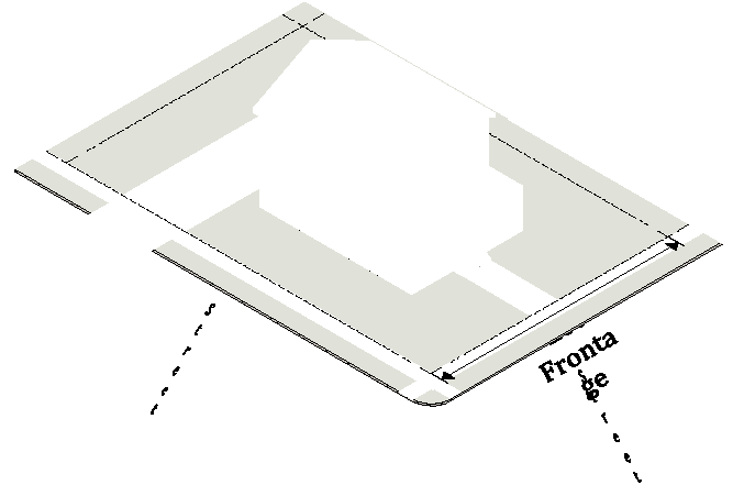
Frontage, street. The distance along a street line from one intersecting street to another or from one intersecting street to the end of a dead-end street.
Functionally dependent use. A use which cannot perform its intended purpose unless it is located or carried out in close proximity to water.
Future conditions flood. The flood having a one percent chance of being equaled or exceeded in any given year based on future-conditions hydrology. Also known as the 100-year future-conditions flood.
Future-conditions flood elevation. The flood standard equal to or higher than the base flood elevation. The "future-conditions flood elevation" is defined as the highest water surface anticipated at any given point during the future-conditions flood.
Future-conditions floodplain. Any land area susceptible to flooding by the future-conditions flood.
Future-conditions hydrology. The flood discharges associated with projected land-use conditions based on a community's zoning map, comprehensive land-use plans, and/or watershed study projections, and with-out consideration of projected future construction of flood detention structures or projected future hydraulic modifications within a stream or other waterway, such as bridge and culvert construction, fill, and excavation.
G
Garage, private. An accessory building designed or used for the storage of vehicles owned and used by the occupants of the building to which it is accessory.
Garage, repair. A building or portion thereof, other than a private, storage or parking garage, designed or used for equipping, servicing, repairing, hiring or selling of motor-driven vehicles, but not including the storage of wrecked or junked vehicles.
Golf driving range. A facility used primarily practicing long golf shots with rentable clubs and balls.
Governing authority. The City Commissioners of the City.
Grade. The average level of the finished ground surface adjacent to the exterior walls of a building.
Grading. Altering the shape of ground surfaces to a predetermined condition; this includes stripping, cutting, filling, stockpiling and shaping or any combination thereof and shall include the land in its cut or filled condition.
Green Globes. A green building rating and certification tool developed by ECD Energy and Environment Canada, an arms-length division of JLL.
Greenspace. Permanently protected land, including agricultural and forestry land, that is in its undeveloped natural state or that has been developed only to the extent consistent with the following:
1) Water quality protection for streams and lakes;
2) Flood protection;
3) Wetlands protection;
4) Reduction of erosion through protection of steep slopes, areas with erodible soils, and stream banks;
5) Protection of riparian buffers and other areas that serve as natural habitat and corridors for native plant and animal species;
6) Scenic protection;
7) Protection of archaeological and historic resources; and/or
8) Provision of recreation in the form of hiking, camping, fishing, hunting and similar outdoor activities.
Ground elevation. The original elevation of the ground surface prior to cutting or filling.
Ground sign. A sign which is supported on one or more uprights or braces on the ground, the overall total height of which does not exceed six feet above the grade.
Group living. See Section 6.3.2.
GSMM. The latest edition of the Georgia Stormwater Management Manual, Volume 2: Technical Handbook, and its Appendices.
Gym, health spa, yoga studio. An establishment which for profit or gain provides as one of its primary purposes, services or facilities which are purported to assist patrons improve their physical condition or appearance. Not included within this definition are facilities operated by nonprofit organizations, facilities wholly owned and operated by a licensed physician at which such physician is engaged in the practice of medicine, or any establishment operated by a health care facility, hospital, intermediate care facility, or skilled nursing care facility.
H
Healthy tree. A tree in fair or better condition with a life expectancy of at least 15 years; a relatively sound and solid trunk with no extensive decay or hollow; less than 20 percent radial trunk dieback; no more than one major and several minor dead limbs; and no major insect or pathological problems.
Highest adjacent grade. The highest natural elevation of the ground surface, prior to construction, adjacent to the proposed foundation of a building.
Highrise business occupancy buildings. All medical, dental and general offices, courthouses, outpatient clinics, town and city halls, college and university instructional buildings, including classrooms for less than 50 persons and instructional laboratories, and similar buildings over 75 feet (23M) in height measured from the lowest level of fire department access to the floor of the highest occupied story.
Highrise residential occupancy buildings. All hotels, dormitories, apartments, lodging houses or roominghouses, board and care facilities over 75 feet (23M) in height, measured from the lowest level of fire department access to the floor of the highest occupied story.
Historic district. A geographically definable area designated by City Commission as a historic district pursuant to the criteria established in Section 5.2.2.B.
Historic property. An individual building, structure, site, object or work of art, including the adjacent area necessary for the proper appreciation thereof, designated by City Commission as a historic property pursuant to the criteria established in Section 5.2.2.C.
Historic structure. Any structure that is:
1) Listed individually in the National Register of Historic Places or preliminarily determined by the Secretary of the Interior as meeting the requirements for individual listing on the National Register;
2) Certified or preliminarily determined by the Secretary of the Interior as contributing to the historical significance of a registered historic district or a district preliminarily determined by the Secretary to qualify as a registered historic district;
3) Individually listed on a state inventory of historic places and determined as eligible by states with historic preservation programs which have been approved by the Secretary of the Interior; or
4) Individually listed on a local inventory of historic places and determined as eligible by communities with historic preservation programs that have been certified either:
a) By an approved state program as determined by the Secretary of the Interior, or
b) Directly by the Secretary of the Interior in states without approved programs.
Home for the elderly. Facilities designed and constructed for housing ambulatory persons or couples over 62 years of age in which ground and floor space may be limited to peculiar needs of such elderly persons.
Home occupation. Any occupation within a dwelling or accessory building and clearly incidental, carried on by a member of the family residing on the premises (see also Section 6.8.3.B.
Hospital, infirmary, sanitarium. A building or group of buildings, having room facilities for one or more abiding patients, used for providing services for the inpatient medical or surgical care of sick or injured humans, and which may include related facilities such as laboratories, outpatient departments, training facilities, central service facilities, and staff offices; provided, however, that such related facility must be incidental and subordinate to the main use and must be an integral part of the hospital operations.
Hotel and motel. A building in which separate sleeping rooms are rented which provide sleeping accommodations for a total of more than 15 persons on either a transient or permanent basis, with or without meals, whether designated as a hotel, inn, club, motel or by any other name.
Hotspot. An area where the use of the land has the potential to generate highly contaminated runoff, with concentrations of pollutants in excess of those typically found in stormwater. As defined by the City Manager, hotspot land use may include gasoline stations, vehicle service and maintenance areas, industrial facilities (both permitted under the Industrial Stormwater General Permit and others), material storage sites, garbage transfer facilities, and commercial parking lots with high-intensity use.
Household. See Section 6.3.1.
Household living. See Section 6.3.1.
Housing Trust Fund. A distinct fund established by the City of Decatur that receives ongoing dedicated sources of funding to support the preservation of affordable housing and development and preservation of inclusionary dwelling units and increase opportunities for families and individuals to access quality affordable homes.
Hydrologic response. The hydrologic response of a property is the manner whereby stormwater collects, remains, infiltrates and is conveyed from a property. It is dependent on several factors including, but not limited to, the presence of impervious area, the size, shape, topographic, vegetative and geologic conditions of a property, antecedent moisture conditions and groundwater conditions on a property.
Hydrologic Soil Group (HSG). A Natural Resource Conservation Service classification system in which soils are categorized into four runoff potential groups. The groups range from group A soils, with high permeability and little runoff produced, to group D soils, which have low permeability rates and produce much more runoff.
I
Illegal connection. Any of the items listed in either of the following:
1) Any pipe, open channel, drain or conveyance, whether on the surface or subsurface, which allows an illicit discharge to enter the storm drain system including, but not limited to, any conveyances which allow any non-stormwater discharge including sewage, process wastewater, and wash water to enter the storm drain system, regardless of whether such pipe, open channel, drain or conveyance has been previously allowed, permitted, or approved by an authorized enforcement agency; or
2) Any pipe, open channel, drain or conveyance connected to the municipal separate storm sewer system which has not been documented in plans, maps, or equivalent records and approved by an authorized enforcement agency.
Impervious cover. A surface composed of any material that significantly impedes or prevents the natural infiltration of water into soil. Impervious surfaces include, but are not limited to, rooftops, buildings, drives, parking spaces, walkways, decks, tennis courts, swimming pools and similar structures, compacted gravel, and any concrete or asphalt surface.
Impervious surface. A surface composed of any material that significantly impedes or prevents the natural infiltration of water into the soil.
Inclusionary dwelling(s). A residential dwelling in the City of Decatur that complies with the affordability requirement in Section 6.3.1.
Inclusionary dwelling unit(s). A residential dwelling unit in the City of Decatur that complies with the affordability requirement in Section 6.3.1.
Inclusionary Housing Plan. A development plan, which consists of information establishing the development's compliance with Section 6.3.1., including a site plan, development land uses, total number of market rate dwelling units and inclusionary dwelling units, unit bedroom mix, average floor area, location of inclusionary dwelling units within the development, development phasing and timing, pricing schedule, draft land use restriction agreement, and a contract with an affordable housing provider, if applicable.
Indoor recreation. See Section 6.5.2.
Industrial activity. Activities subject to NPDES industrial permits as defined in 40 CFR, section 122.26(B)(14).
Industrial stormwater permit. The National Pollutant Discharge Elimination System (NPDES) permit issued by Georgia Environmental Protection Division to an industry for stormwater discharges associated with industrial activity. The permit regulates pollutant levels associated with industrial stormwater discharges or specifies on-site pollution control based on Standard Industrial Classification (SIC) Code.
Industrialized Building. A structure meeting the definition of "industrialized building" set forth in O.C.G.A. section 8-2-111, as amended, and that bears a valid insignia of approval issued by the Georgia Department of Community Affairs pursuant to the Georgia Industrialized Building Act, as amended.
Infiltration. The process of percolating stormwater runoff into the subsoil.
Infirmary. See Hospital.
Inspection and maintenance agreement. A written agreement providing for the long-term inspection and maintenance of stormwater management facilities and practices on a site or with respect to a land development project, which when properly recorded in the deed records constitutes a restriction on the title to a site or other land involved in a land development project.
Institution. A building occupied by a nonprofit corporation or a nonprofit establishment for public use.
Interested parties (substandard building). Interested parties are as follows:
1) Owner;
2) Those parties having an interest in the property as revealed by a certification of title to the property conducted in accordance with the title standards of the State Bar of Georgia;
3) Those parties having filed a notice in accordance with O.C.G.A. § 48-3-9;
4) Any other party having an interest in the property whose identity and address are reasonably ascertainable from the records of the petitioner of records maintained in the county courthouse or by the clerk of the court. Interested parties shall not include the holder of the benefit or burden of any easement or right-of-way whose interest is properly recorded, which interest shall remain unaffected; and
5) Persons in possession of said property and premises.
ISA. International Society of Arboriculture; an organization that promotes the professional practice of arboriculture and fosters an awareness of the benefits of trees through research, technology and education.
J
Jurisdictional wetland. An area that is inundated or saturated by surface water or groundwater at a frequency and duration sufficient to support a prevalence of vegetation typically adapted for life in saturated soil conditions, commonly known as hydrophytic vegetation.
K
Kennel. A building or establishment where the principal service is the boarding of animals.
L
Land development. Any land change, including, but not limited to, clearing, grubbing, stripping, removal of vegetation, dredging, grading, excavating, transporting and filling of land, construction, paving and any other installation of impervious cover.
Land development activity. Those actions or activities which comprise, facilitate or result in land development.
Land development application. The application for a land development permit on a form provided by the City along with the supporting documentation required in Section 9.3.4
Land development project. A discrete land development undertaking.
Land disturbance. Any land or vegetation change including, but not limited to, clearing, grubbing, stripping, removal of vegetation, dredging, grading, excavating, and transporting and filling of land, and that does not include construction, paving or any other installation of impervious cover.
Land use restriction agreement (LURA). A land use restriction agreement between the City and the developer that encumbers a parcel in a manner that will require compliance with the Inclusionary Dwelling provisions in Section 6.3.1., including the development and active marketing of a percentage of dwelling units as inclusionary dwelling units.
Land-disturbing activity. Any activity which may result in soil erosion from water or wind and the movement of sediments into state waters or onto lands within the state, including, but not limited to, clearing, dredging, grading, excavating, transporting, and filling of land but not including agricultural practices as described in Section 9.4.3.
Landmark tree. A tree of special significance and designated for protection by the City Commission as described in Section 9.1.15.
Landscaping. Planting of grass or other ground cover and ornamental trees and shrubs for beautification and screening purposes.
Larger common plan of development or sale. A contiguous area where multiple separate and distinct construction activities are occurring under one plan of development or sale. For the purposes of this paragraph, "plan" means an announcement; piece of documentation such as a sign, public notice or hearing, sales pitch, advertisement, drawing, permit application, zoning request, or computer design; or physical demarcation such as boundary signs, lot stakes, or surveyor markings, indicating that construction activities may occur on a specific plot.
LEED. The Leadership in Energy and Environmental Design green building rating systems which are nationally accepted standards for green buildings developed by the USGBC.
Library, museum, public. A facility having public significance by reason of its architecture or former use or occupancy, or a building serving as a repository for a collection of books, natural, scientific, literary curiosities or objects of interest, or works of art, and arranged, intended, and designed to be viewed by members of the public, with or without an admission fee, and which may include as an accessory use the sale of goods to the public as gifts or for their own use.
Lifecycle dwelling. A type of dwelling which is designated so that the rent or purchase price is affordable by a family whose income is a percentage of the area median income (AMI) for families in the Atlanta metropolitan statistical area, as established by the U.S. Department of housing and urban development. Lifecycle dwellings are intended to providing housing opportunities for persons and families of moderate income, the elderly, employees of public agencies and local business and similar classes. Such designation shall be through the use of deed restrictions, project agreements, conditional zoning or other effective means.
Light industrial. See Section 6.6.1.
Linear feasibility program. A feasibility program developed by the City and submitted to the Georgia Environmental Protection Division, which sets reasonable criteria for determining when implementation of stormwater management standards for linear transportation projects being constructed by the City is infeasible.
Linear transportation project. All construction projects on traveled ways including, but not limited to, roads, sidewalks, multi-use paths and trails, and airport runways and taxiways.
Loading space. A space having minimum dimensions of 13 by 45 feet and a vertical clearance of at least 14½ feet within the main building or on the same lot, providing for the standing, loading or unloading of trucks.
Local designated property manager. The responsible party for a short term rental who is available 24 hours per day, seven days per week during all times that the property is used for short term rental. Designated property managers may be professional property managers, realtors, property owners, or other designated persons who are at least 21 years of age. The local designated property manager must be able to travel to the short term rental within one hour of being contacted.
Local issuing authority. The governing authority of the City, which is certified pursuant to O.C.G.A. § 12-7-8(a).
Lodginghouse or roominghouse. A building in which separate sleeping rooms are rented which provide sleeping accommodations for a total of 15 or less persons on either a transient or permanent basis, with or without meals, but without separate cooking facilities for individual occupants.
Lot. A portion of a subdivision intended as a unit for transfer of ownership or for development, or both. In determining the area and dimensions of a lot, no part of the right-of-way of a road or crosswalk may be included
Lot, corner. A lot abutting upon two or more streets at their intersection.
Lot coverage. A percentage factor which, when multiplied by the total area of any lot, establishes the total area of impervious cover which may be built on said lot. Where used in the zoning ordinance, the term coverage shall mean lot coverage.
Lot, double frontage. A through lot having a frontage on two nonintersecting streets as distinguished from a corner lot.
Lot frontage. The linear distance measured in feet along which the lot fronts a public right-of-way.
Lot of record. A lot which is part of a subdivision, the map of which has been recorded in the office of the clerk of the superior court of DeKalb county or a parcel of land, the deed of which was recorded in the office of the clerk of the superior court of DeKalb county.
Lot width. The width of a lot at the building line measured parallel to the street right-of-way line.
Lowest floor. The lowest floor of the lowest enclosed area, including basement. An unfinished or flood resistant enclosure, used solely for parking of vehicles, building access, or storage, in an area other than a basement, is not considered a building's lowest floor, provided that such enclosure is not built so as to render the structure in violation of other provisions of this article.
M
Major automobile repair. The term "major repair" shall include such activities as painting or spray painting; repair to body, fender, bumper, clutch, transmission, differential, axle, spring, or similar part; overhaul or repair of engine requiring removal of cylinder head or crankcase pan; repair of radiator requiring removal from vehicle; recapping and retreading of tires; or similar activities.
Major utilities. Public or private infrastructure, including, but not limited to, water, sewer, gas, electric, telephone, internet, cable and other similar services serving the general community and possibly having on-site personnel.
Manufactured (mobile) home. A structure, transportable in one or more sections, which, in the traveling mode, is eight body feet or more in width or 40 body feet or more in length, when erected on site, is 320 or more square feet in floor area, and which is built on a permanent chassis and designed to be used as a dwelling with or without a permanent foundation when connected to the required utilities, and includes the plumbing, heating, air conditioning, and electrical systems contained therein; or a structure that otherwise comes within the definition of a "manufactured home" under the National Manufactured Housing Construction and Safety Standards Act of 1974, as amended (42 U.S.C. 5401-5445).
Market garden, small. A parcel less than 5,000 square feet that is managed and maintained by an individual, group of individuals or organization for urban agriculture. All livestock shall be prohibited. Animal facilities shall be setback a minimum of 75 feet from the property lines.
Market garden, medium. A parcel greater than or equal to 5,000 square feet but no greater than two acres that is managed and maintained by an individual, group of individuals or organization for urban agriculture. Animals used in food production shall be permitted with the exception of roosters. Animal facilities shall be setback a minimum of 75 feet from the property lines.
Market garden, large. An area of land greater than two acres that is managed and maintained by an individual, group of individuals or organization for urban agriculture. Animals used in food production shall be permitted with the exception of roosters. Animal facilities shall be setback a minimum of 75 feet from the property lines.
Market rate dwelling unit(s). A residential unit that is not an inclusionary dwelling unit.
Marquee. Any roofed structure attached to and supported by a building and projecting over public or private sidewalks or right-of-way.
Marquee sign. Any sign painted on, attached to, or hung from a marquee.
Master plan. A comprehensive plan, which may consist of several maps, data and other descriptive matter, for the physical development of the City, or any portion thereof, including any amendments, extensions or additions thereto approved by the City Commission, indicating the general location for major roads, parks or other public open spaces, public building sites, routes for public utilities, zoning districts or other similar information.
Material change in appearance. A change that will affect either the exterior architectural or environmental features of a historic property or any building, structure, site, object, landscape feature or work of art within a historic district, such as:
1) A reconstruction or alteration of the size, shape or facade of a historic property, including any doors or windows or removal or alteration of any architectural features, details or elements;
2) Demolition or relocation of a historic structure;
3) Commencement of excavation for construction purposes;
4) A change in the location of advertising visible from a public right-of-way; or
5) The erection, alteration, restoration or removal of any building or other structure within a historic property or district, including walls, fences, steps and pavements, or other appurtenant features.
Mature canopy size. The potential amount of canopy that can be expected for a species at maturity, categorized as very small, small, medium and large.
Mean sea level. The average height of the sea for all stages of the tide. It is used as a reference for establishing various elevations within the floodplain. For purposes of this article the term is synonymous with national geodetic vertical datum (NGVD) and/or the north American vertical datum (NAVD) of 1988.
Medical. See Section 6.5.3.
Minor automobile repair. The term "minor repair" shall include such activities as engine tune-up; servicing of spark plugs, batteries, distributors and similar items; replacement of mufflers, tail pipes, water hose, fan belts, brake fluid, light bulbs, fuses, floor mats, seat belts, seat covers, windshield wipers and blades, grease retainers, wheel bearings, mirrors and similar items; cleaning and flushing of radiators; repair or replacement of fuel pumps and lines; minor servicing or repair of carburetors; minor repairs to electrical system; minor adjustment of motors not involving removal of head or crankcase or racing motors; or similar activities.
Minor utilities. Public or private infrastructure, including, but not limited to, water, sewer, gas, electric, telephone, internet, cable and other similar services serving a limited area with no on-site personnel.
Monastery, convent. A place of residence providing group living accommodations to a community of persons living in seclusion under religious vows.
Motel. A building or group of buildings used for the temporary occupancy of transient motorists and containing no facilities for cooking in the individual units. Ingress or egress to rooms need not be through a lobby or office.
Motorized home. A portable dwelling designed and constructed as an integral part of a self-propelled vehicle.
MS4 Permit. The NPDES permit issued by Georgia Environmental Protection Division for discharges from the City's municipal separate storm sewer system.
Multiple-family dwelling. A building containing five or more living units with independent cooking and bathroom facilities, whether designated as apartment house, tenement, garden apartment, or by any other name.
Multiple-family dwelling unit residential properties. Multiple-family dwelling unit residential properties shall mean developed land whereon five or more residential dwelling units are located, and shall include, but not be limited to apartment houses, structures containing multiple residential condominiums located on a single parcel, boarding houses, group homes, personal care homes, homes for the elderly, retirement and nursing homes, and other structures in which more than one family group commonly and normally reside or could reside. In the application of storm water service fees, multiple-family dwelling unit residential properties shall be treated as other developed lands as defined in this article.
Municipal separate stormwater system. Any facility designed or used for collecting and/or conveying stormwater, including, but not limited to, any roads with drainage systems, highways, municipal streets, curbs, gutters, inlets, catch basins, piped storm drains, pumping facilities, structural stormwater controls, ditches, swales, natural and human-made or altered drainage channels, reservoirs, and other drainage structures, and which is:
1) Owned or maintained by the City;
2) Not a combined sewer; and
3) Not part of a publicly-owned treatment works.
N
National Geodetic Vertical Datum (NGVD) as corrected in 1929. A vertical control used as a reference for establishing varying elevations within the floodplain.
National Green Building Standard. A rating and certification system jointly developed by the National Association of Home Builders (NAHB), building science society ASHRAE, and the International Code Council (ICC), developers of the ICC Family of Codes, to encourage increased environmental and health performance in residences and residential portions of buildings.
National Pollutant Discharge Elimination System (NPDES) Stormwater Discharge Permit. A permit issued by the Georgia EPD under authority delegated pursuant to 33 U.S.C. § 1342(b) that authorizes the discharge of pollutants to waters of the United States, whether the permit is applicable on an individual, group, or general area-wide basis.
National Register of Historic Places. The United States' official list of cultural resources worthy of preservation. Authorized under the National Historic Preservation Act of 1966 (Public Law 89-665; 16 U.S.C. 470 et seq.), the National Register is part of a national program to coordinate and support public and private efforts to identify, evaluate, and protect our historic and archaeological resources. Properties listed in the Register include districts, sites, buildings, structures, and objects that are significant in American history, architecture, archeology, engineering, and culture. The National Register is administered by the National Park Service, which is part of the U.S. Department of the Interior.
Natural ground surface. The ground surface in its original state before any grading, excavation or filling.
Nephelometric Turbidity Units (NTU). Numerical units of measure based upon photometric analytical techniques for measuring the light scattered by finely divided particles of a substance in suspension. This technique is used to estimate the extent of turbidity in water in which colloidally dispersed or suspended particles are present.
Net critical root zone impact. The area of the critical root zone that has been obstructed with barriers from the urban environment, e.g., streets, walls, building foundations, etc. To evaluate the feasibility of tree preservation, the area of canopy coverage shall be reduced by the area of the net critical root zone canopy area that overlaps the obstruction.
New construction. Any structure (see definition) for which the "start of construction" commenced after May 5, 1992, the date of adoption of Ordinance No. O-92-13, flood damage prevention, and includes any subsequent improvements to the structure.
Net development area. The area determined by subtracting any areas set aside for street right-of-way, drainage facilities or areas, churches and schools from the total area of the development. Any area set aside for common open areas or passive recreational uses shall be included in the net development area.
New development. A land development activity on a previously undeveloped site.
New development (Stormwater Management—Section 9.3). Land disturbing activities, structural development (construction, installation or expansion of a building or other structure), and/or creation of impervious surfaces on a previously undeveloped site.
New manufactured home park or subdivision. A manufactured home park or subdivision for which the construction of facilities for servicing the lots on which the manufactured homes are to be affixed (including at a minimum, the installation of utilities, the construction of streets, and either final site grading or the pouring of concrete pads) is completed on or after May 5, 1992.
NOI. A notice of intent form provided by EPD for coverage under the state general permit.
Noncommercial message. Any sign, wording, logo or other visual representation that does not directly or indirectly constitute or include a commercial message, but instead conveys an opinion, idea or concept, or similar noncommercial speech.
Nonconforming sign. Any lawfully erected sign which, on the effective date of the ordinance from which this Section derives, fails to comply with the requirements of this chapter.
Nonconforming use. Any building or land lawfully occupied by a use at the time of passage of the ordinance or amendment thereto which does not conform after the passage of this UDO or amendment thereto with the use regulations of the district in which it is situated. Existing improvements which do not meet required parking and loading regulations, height regulations, area regulations, and residential floor area regulations for the district in which they are located are not nonconforming uses as defined above.
Nonpoint source pollution. A form of water pollution that does not originate from a discrete point such as a sewage treatment plant or industrial discharge, but involves the transport of pollutants such as sediment, fertilizers, pesticides, heavy metals, oil, grease, bacteria, organic materials and other contaminants from land to surface water and groundwater via mechanisms such as precipitation, stormwater runoff, and leaching. Nonpoint source pollution is a by-product of land use practices such as agricultural, silvicultural, mining, construction, subsurface disposal and urban runoff sources.
Non-profit. An organization organized and operated exclusively for exempt purposes set forth in Section 501(c)(3) of the Internal Revenue Service Code, and none of its earnings may inure to any private shareholder or individual. In addition, it may not be an action organization, for example, it may not attempt to influence legislation as a substantial part of its activities and it may not participate in any campaign activity for or against political candidates.
Non-stormwater discharge. Any discharge to the storm drain system that is not composed entirely of stormwater.
Nonstructural stormwater management practice or nonstructural practice. A means any natural or planted vegetation or other nonstructural component of the stormwater management plan that provides for or enhances stormwater quantity and/or quality control or other stormwater management benefits, and includes, but is not limited to, riparian buffers, open and greenspace areas, overland flow filtration areas, natural depressions, and vegetated channels.
North American Vertical Datum (NAVD) of 1988. A vertical control used as a reference for establishing varying elevations within the floodplain.
NOT. A notice of termination form provided by EPD to terminate coverage under the state general permit.
Nursery school. Any premises or portion thereof used for educational work or parental care of children of less than six years of age.
Nursing home. A facility which admits patients on medical referral only and for whom arrangements have been made for continuous medical supervision and which maintains the services and facilities for skilled or rehabilitative nursing care, and has a satisfactory agreement with a physician and dentist who will be available for any medical and/or dental emergency and who will be responsible for the general medical and dental supervision of the home in accordance with the definition of nursing home set forth in the Georgia Administrative Code 290-5-8-.01, as amended. No personal care home, assisted living facility, rehabilitation center or any other type of facility may be permitted under this definition as a nursing home unless it meets the definition of nursing home set forth in the Georgia Administrative Code and is licensed by the State of Georgia as a nursing home.
O
Occupancy classification. The use to which the structure is put. The various classifications shall be:
1) Single-family residential;
2) Multifamily residential;
3) Commercial;
4) Industrial;
5) Office;
6) Institutional; and
7) Governmental.
Off-premises sign. Any sign not located on the same premises as the person, business, commodity, service, entertainment or any other thing which it advertises or to which it relates, including any structure designed primarily for the display of off-site signs or advertising structures.
Off-site facility. A stormwater management facility located outside the boundaries of the site.
Office. See Section 6.5.4.
Office-type business. A business or professional office which does not have frontage on a public street. For example, a business located in an office building or similar facility and which is entered from a hallway or corridor connected to a common building entrance.
Open space. Uses focusing on natural areas consisting mostly of vegetation, passive or active outdoor recreation areas, and having few structures.
Operator. The party or parties that have:
1) Operational control of construction project plans and specifications, including the ability to make modifications to those plans and specifications; or
2) Day-to-day operational control of those activities that are necessary to ensure compliance with an erosion, sedimentation and pollution control plan for the site or other permit conditions, such as a person authorized to direct workers at a site to carry out activities required by the erosion, sedimentation and pollution control plan or to comply with other permit conditions.
Other developed lands. Other developed lands shall mean, but not be limited to, multiple-family dwelling unit residential unit properties, manufactured home and mobile home parks, commercial, retail and office buildings, public buildings and structures, industrial and manufacturing buildings, storage buildings and storage areas covered with impervious surfaces, railroad stations and other transportation facilities covered by impervious surfaces, parking lots and decks, parks and other recreational properties, public and private schools and universities, research facilities and stations, hospitals and convalescent centers, agricultural uses covered by impervious surfaces, and water and wastewater treatment plants and all other types of developed land except single-family dwelling units.
Outdoor advertising. Advertising on any board, fence or structure or the placing thereon of any poster, bill, printing, painting, device or any advertising matter of any kind, and the pasting, posting, painting, printing, nailing or tacking or otherwise fastening of any handbill, card, banner, sign, poster, advertising or notice of any kind upon any property or place.
Outdoor recreation. See Section 6.5.5.
Outfall. The location where storm water in a discernible, confined and discrete conveyance, leaves a facility or site or, if there is a receiving water on site, becomes a point source discharging into that receiving water.
Overbank flood protection. Measures taken to prevent an increase in the frequency and magnitude of out-of-bank flooding (i.e. Flow events that exceed the capacity of the channel and flow on to adjacent land and/or enter the floodplain), and that are intended to protect downstream properties from flooding for the two-year through 25-year frequency storm events.
Overnight lodging. See Section 6.5.6.
Owner. The legal or beneficial owner of a parcel or structure thereon, including, but not limited to, a mortgagee or vendee in possession, receiver, executor, trustee, lessee or other person, firm or corporation in control of said parcel or structure.
P
Parcel. Any plot, lot or acreage shown as a unit on the latest county tax assessment records.
Parks and Recreation. See Section 6.4.2.
Parking. See Section 6.5.7.
Parking lot. A lot used exclusively for the temporary storage of motor vehicles.
Parking space. A space enclosed or unenclosed, for vehicle storage space exclusive of driveways, permanently reserved for the temporary storage of a vehicle and directly connected with a street or alley by a driveway.
Pedestrian walk. A right-of-way within a block dedicated to public use, ten feet or more in width, intended primarily for pedestrians and from which motor propelled vehicles are excluded, and which is designed to improve or provide access to adjacent roads or lots.
Permit. The permit issued by the UDO Administrator required for undertaking any land development activity.
Permitted use. The purpose or function that a lot serves or is supposed to serve that is permitted within the zoning districts described in the zoning ordinance.
Person. Any individual, partnership, firm, association, joint venture, public or private corporation, trust, estate, commission, board, public or private institution, utility, cooperative, City, county or other political subdivision of the State of Georgia, any interstate body or any other legal entity.
Personal care facility. A personal care home, assisted living facility or nursing home.
Personal care home. A dwelling, facility or structure required to be licensed or registered with the State of Georgia as a personal care home. Any dwelling, facility or structure which for any reason is not required to be licensed or registered with the State of Georgia as a personal care home, or fails to be licensed or registered with the State of Georgia as a personal care home but which, through its ownership or management undertakes for a fee or accepts a grant or utilizes its own funding to provide or arrange for the provision of housing, food service, and one or more personal services for two or more persons who are not related to the owner or administrator by blood, marriage or adoption shall also be considered a personal care home for the purpose of this definition. No use defined as a personal care home may be permitted as a home occupation. This definition shall apply without regard to whether any fee is paid by the individual to whom the services are provided or by another person, the source of the grant, or the funding source for the operational costs and without regard to whether the facility is operated for profit or not for profit. Personal services include, but are not limited to, individual assistance with or supervision of self-administered medication, and essential activities of daily living such as bathing, grooming, dressing and toileting. For the purposes of this ordinance, a "child caring institution" or "group-care facility" as defined in O.C.G.A. § 49-5-3, as amended, shall also be considered a personal care home.
Personal service. See Section 6.5.8.
Pickup coach. A structure designed primarily to be mounted on a pickup truck or truck chassis and with sufficient equipment to render it suitable for use as a temporary dwelling for travel, recreational and vacation uses.
Place of worship, including church, mosque, synagogue, temple. A building or structure that by design and construction is primarily intended for conducting organized religious services. Associated accessory uses include, but are not limited to, schools, meeting halls, indoor and outdoor recreational facilities, clergy house, day care, counseling and kitchens.
Planned Unit Development. A parcel of land of at least one acre in area, under single, corporation, firm, partnership, or association ownership, planned and developed as an integral unit, in a single development operation or a definitively programmed series of development operations and according to a development plan approved this UDO.
Planning Commission. The City Planning Commission.
Plat. A map indicating the subdivision or resubdivision of lands, intended to be filed for record.
Plumbing fixtures. Any toilet, urinal, showerhead, bathroom, lavatory and kitchen faucet and replacement aerators.
Pole sign. Any sign erected on one or more uprights supported from the ground, the height of which is greater than eight feet, and which is not a part of any building or structure, other than a structure erected solely for the purpose of supporting the sign. The overall total height of a pole sign shall not exceed 25 feet above ground level. A pole sign may include an accessory sign or change-able copy panel, the areas of which shall be included in the total area of the pole sign.
Political sign. A sign informing the public of an election issue, political issue, candidate for public office, or similar noncommercial campaign.
Pollutant. Anything which causes or contributes to pollution. Pollutants may include, but are not limited to: paints, varnishes, and solvents; petroleum hydrocarbons; automotive fluids; cooking grease; detergents (biodegradable or otherwise); degreasers; cleaning chemicals; non-hazardous liquid and solid wastes and yard wastes; refuse, rubbish, garbage, litter, or other discarded or abandoned objects and accumulations, so that same may cause or contribute to pollution; floatables; pesticides, herbicides, and fertilizers; liquid and solid wastes; sewage, fecal coliform and pathogens; dissolved and particulate metals; animal wastes; wastes and residues that result from constructing a building or structure; concrete and cement; and noxious or offensive matter of any kind.
Pollution. The contamination or other alteration of any water's physical, chemical or biological properties by the addition of any constituent and includes, but is not limited to, a change in temperature, taste, color, turbidity, or odor of such waters, or the discharge of any liquid, gaseous, solid, radioactive, or other substance into any such waters as will or is likely to create a nuisance or render such waters harmful, detrimental or injurious to the public health, safety, welfare, or environment, or to domestic, commercial, industrial, agricultural, recreational, or other legitimate beneficial uses, or to livestock, wild animals, birds, fish or other aquatic life.
Poor-rated tree. Any tree in a state of decline with uncorrectable major defects or untreatable disease severe enough to present a danger to people or buildings under normal conditions, as determined by a certified arborist and verified by the City Arborist.
Portable sign. Any sign which is designed to be transported by any means, including by trailer or on its own wheels, even though the wheels of such sign may be removed and the remaining chassis or support constructed without wheels is attached temporarily or permanently to the ground, or any movable sign structure designed for transport, which is placed, parked or maintained at a particular location for the express purpose of promotion or conveying an advertising message. It is typical of such signs that the space provided for advertising matter consists of a changeable copy panel.
Post-construction stormwater management. Stormwater best management practices that are used on a permanent basis to control and treat runoff once construction has been completed in accordance with a stormwater management plan.
Post-development. The time period, or the conditions that may reasonably be expected or anticipated to exist, onsite immediately after completion of the land development activity on a site as the context may require.
Practicability policy. The latest edition of the City's Policy on Practicability Analysis for Runoff Reduction. Pre-development. The time period, or the conditions that exist, on a site prior to the commencement of a land development project and at the time that plans for the land development of a site are approved by the plan approving authority, provided however that the runoff coefficient to be used for purposes of computation of the stormwater quality or detention requirement for the pre-developed condition of an existing impervious area that is removed shall revert to the coefficient for such area in its natural undeveloped state. Where phased development or plan approval occurs (preliminary grading, roads and utilities, etc.), The existing conditions at the time prior to the first item being approved or permitted hall establish pre-development conditions.
Pre-development hydrology. The runoff curve number determined using natural conditions hydrologic analysis based on the natural, undisturbed condition of the site immediately before implementation of the proposed development
Pre-engineered metal building. A structure which includes a pre-engineered and shop-fabricated structural steel building frame, metal wall and sloped roof system, and exterior doors and windows, which has been manufactured so as to facilitate erection at a location other than where it was fabricated. This term does not include greenhouses, garden sheds and similar structures not exceeding 150 square feet of floor area.
Preliminary plat. A drawing which shows the proposed layout of a subdivision in sufficient detail to indicate unquestionably its workability, but is not in final form for recording, pursuant to this UDO.
Premises. Any building, lot, parcel of land, or portion of land whether improved or unimproved including adjacent sidewalks and parking strips.
Previously developed site. A site that has been altered by paving, construction, and/or land disturbing activity.
Price pane. Any sign or panel incorporated into a sign or sign device and having changeable numerals used for the purpose of displaying variable price information.
Privately-owned public open spaces (POPOS). Publicly accessible spaces in forms of plazas, terraces, atriums, small parks, and pedestrian corridors, which are provided and maintained by private property owners pursuant to formal arrangement with the city, such as through an agreement, restrictive covenant, or land use or zoning condition of approval.
Professional engineer. A professional engineer registered in the State of Georgia.
Project. The entire proposed development project regardless of the size of the area of land to be disturbed.
Projecting sign. Any sign mounted on the face or vertical surface of a building or structure, the display surfaces of which are not parallel to the supporting surfaces.
Proper identification. Any document issued by a governmental agency containing a description of the person, such person's photograph, or both, and giving such person's date of birth, and includes without being limited to, a passport, military identification card, drivers license, or an identification card authorized under O.C.G.A. §§ 40-5-100 through 40-5-104.
Properly designed. Designed in accordance with the design requirements and specifications contained in the manual for erosion and sediment control in Georgia (manual) published by the Georgia soil and water conservation commission as of January 1 of the year in which the land-disturbing activity was permitted and amendments to the manual as approved by the commission up until the date of NOI submittal.
Protected tree. Any tree that is 6 inches DBH or greater that is structurally sound; any tree that has been planted or conserved to comply with this Section regardless of size, any tree planted on public or private property using Tree Bank funds and any tree planted pursuant to Section 9.1.9. Trees listed on the GA EPPC Invasive Species List, Category 1 shall not be considered protected trees (https://www.gaeppc.org/list/).
Protection area, or stream protection area. With respect to a stream, the combined areas of all required buffers and setbacks applicable to such stream which are required around the area of the stream itself.
Public. The term "public," when used as a modifier for such words as building, school, facility, community building, library, art gallery, utility and similar words, shall mean "government-owned" or "government-operated."
Public authority. Any member of the City Commission of the City, any officer of the Decatur housing authority, and any officer who is in charge of any department or branch of the government of the City or the State of Georgia relating to health, fire, or building regulations or to other activities concerning dwellings, buildings or structures in the City, specifically including the City fire marshal, the City fire chief, the City police chief, and the City codes enforcement officers.
Public facility. Public museums, art galleries, libraries, buildings, government buildings office, and structures.
Public officer. The officer or officers who are authorized by O.C.G.A. §§ 41-2-7, 41-2-8 and 41-2-9 through 41-2-17 and by this article to exercise the powers prescribed by this article or any agent of such officer or officers.
Public property. Property which is owned, leased or controlled by the city, county, or state or any public board, commission, or authority.
Public tree. Any tree whose trunk is located either wholly or partially on public property.
Public utilities. See Section 6.4.3.
Q
Qualified professional. An individual possessing a degree in forestry, urban forestry, landscape architecture or horticulture and certified or registered by the state or a professional board, or a certified arborist.
R
Radio, television studio. A facility in which video, radio or sound production takes place, either for live broadcasting or for the acquisition of raw footage for post-production.
Real estate sign. Any temporary sign advertising the sale, rental or lease of the property on which the sign is located.
Recreational vehicle. A vehicle which is:
Built on a single chassis;
1) 400 square feet or less when measured at the largest horizontal projection;
2) Designed to be self-propelled or permanently towable by light duty truck; and
3) Designed primarily not for use as a permanent dwelling but as temporary living quarters for recreational, camping, travel, or seasonal use.
Redevelopment.
1) Stormwater Management (Section 9.3)—A structural development project (construction, installation, or expansion of a building or other structure), creation or addition of impervious surfaces, replacement of impervious surfaces not as part of routine maintenance, and land disturbing activities associated with structural or impervious development on a previously developed site. Redevelopment does not include such activities as exterior remodeling.
2) Soil Erosion and Sedimentation Control (Section 9.4)—A land development project on a previously developed site, but excludes ordinary maintenance activities, remodeling of existing buildings not involving a substantial improvement or an addition, resurfacing of paved areas, and exterior changes or improvements which do not materially increase or concentrate stormwater runoff, or cause additional nonpoint source pollution.
Regional stormwater management facility or stormwater facility. Stormwater management facilities designed to control stormwater runoff from multiple properties, where the owners or developers of the individual properties may assist in the financing of the facility, and the requirement for individual on-site controls is either eliminated or reduced.
Remote parking. A facility that provides parking as a principal use that is used to meet the off-site parking provisions of Section 4.6.7.A.
Repair. Altering or improving a dwelling, building, or structure so as to bring the structure into compliance with the applicable codes in the jurisdiction where the property is located and the cleaning or removal of debris, trash, and other materials present and accumulated, which create a health or safety hazard in or about any dwelling, building, or structure.
Repair of appliances. Including bicycles, canvas product clocks, computers, jewelry, musical instruments, office equipment, radios, shoes, televisions, watch, or similar items.
Repair shops. Shops specializing in the repair of appliances, bicycles, canvas product clocks, computers, jewelry, musical instruments, office equipment, radios, shoes, televisions, watch, or similar items.
Research and development. See Section 6.6.3.
Resident. Any person residing in the jurisdiction where the property is located on or after the date on which the alleged nuisance arose.
Residential building. Any building or unit of a building intended for occupancy as a dwelling but shall not include a hotel or motel.
Residential real estate sign. Any temporary sign advertising the sale, rental or lease of the residential property on which the sign is located.
Restaurant with drive-though. A restaurant designed so that at least part of the customers can be served while remaining in their vehicles.
Retail sales. See Section 6.5.10.
Riparian. Belonging or related to the bank of a river, stream, lake, pond or impoundment.
Roadway drainage structure. A device such as a bridge, culvert, or ditch, composed of a virtually non-erodible material such as concrete, steel, plastic, or other such material that conveys water under a roadway by intercepting the flow on one side of a traveled roadway consisting of one or more defined lanes, with or without shoulder areas, and carrying water to a release point on the other side.
Roof sign. Any sign which is fastened to and supported by or on the roof of a building or which extends above the roof of a building.
Roominghouse, boardinghouse. A building other than a hotel where lodging for three or more persons not of the immediate family is provided for definite periods and for compensation and by prearrangement for definite periods.
Roots. The system of large, woody structural roots that physically support a tree and fine, fibrous feeder roots that absorb water and nutrients for tree growth and survival.
Rotating sign. Any sign which is designed to revolve or rotate.
Routine Maintenance. Activities to keep an impervious surface as near as possible to its constructed condition. This includes ordinary maintenance activities, resurfacing paved areas, and exterior building changes or improvements which do not materially increase or concentrate stormwater runoff, or expose underlying soil, or cause additional nonpoint source pollution.
Row house. A type of multiple dwelling connected to other units at end walls.
Runoff. Stormwater runoff.
S
Sanitarium. See Hospital.
Satellite dish antenna. A device incorporating a reflective surface that is solid, open mesh or bar-configured and is in the shape of a shallow dish, cone, horn or cornucopia. Such device is used to transmit and/or receive radio or electromagnetic waves between terrestrially and/or orbitally based uses. This definition is meant to include, but not be limited to, what are commonly referred to as satellite earth stations and/or satellite microwave antennas.
Scaffold limbs. The main structural limbs that support the remainder of the tree's crown.
School, private (k-12). An educational facility for students in grades pre-kindergarten through 12 not operated by the DeKalb County Board of Education that has a curriculum at least equal to a public school with regard to the branches of learning and study required to be taught in the public schools of the State of Georgia.
School, public (k-12). An educational facility for students in grades pre-kindergarten through 12 operated by the City of Decatur Board of Education. Includes charter schools.
Sediment. Solid material, both organic and inorganic, that is in suspension, is being transported, or has been moved from its site of origin by wind, water, ice, or gravity as a product of erosion.
Sedimentation. The process by which eroded material is transported and deposited by the action of water, wind, ice or gravity.
Self-service storage. See Section 6.6.4.
Service station. Any building or land used for the dispensing, sale or offering for sale at retail of any automobile fuels, oils or accessories and in connection with which is performed general automotive servicing as distinguished from automotive repairs.
Setback.
1) See Yard.
2) With respect to a stream, the area established by Section 9.2.5.A. extending beyond any buffer applicable to the stream.
Short-term rental. The primary use of all or part of a dwelling unit by rental for temporary occupancy for dwelling, sleeping, or lodging of less than 30 consecutive days.
Short-term rental owner. The owner of record of the short term rental.
Sign. Any writing, pictorial presentation, illustration, decoration, flag, banner, display, spectacle, statuary or other device or visual medium, including its structure and component parts, which:
1) Is used or intended to be used to announce, attract attention to, identify, advertise, or otherwise make anything known; and
2) Is visible from any public street, public road, public right-of-way or adjoining property.
3) The term "sign" shall not be deemed to include the terms "building" or "landscaping," or any architectural embellishment of a building not designed to communicate information.
Sign Area. The area within a continuous perimeter enclosing the limits of writing, representation, emblem, or any figure of similar character, together with any frame or other material or color forming an integral part of the display or used to differentiate such sign from the background against which it is placed, excluding the necessary supports or uprights on which such sign is placed; provided, however, that any open space contained within the outer limits of the display face of a sign or between any component, panel, strip, or figure of any kind composing the display face shall be included in the computation of the area of the sign, whether such open space be enclosed or not by a frame or border. For projecting or double-faced signs, only one display face shall be measured in computing sign area where the sign faces are parallel or where the interior angle formed by the faces is 60 degrees or less. If the two faces of a double-faced sign are of unequal area, the area of the sign shall be taken as the area of the larger face.
Sign official. Any person charged with the administration and enforcement of appropriate provisions of this chapter.
Sign structure. The supports, uprights, braces and framework of the sign.
Single-family dwelling unit. Single-family dwelling unit shall mean developed land upon which is located one principal structure that contains one dwelling unit designed for occupancy by one family, with a bathroom and kitchen facilities. Single-family dwelling units may include houses, duplexes, walk up flats, manufactured homes, mobile homes located on one or more individual lots or parcels of land, and fee-simple ownership or condominium townhomes and attached single-family residential structures located on individual lots or parcels of land and such single units located on more than one individual lot or parcel of land. For the purposes of this article, developed land may be classified as a single-family dwelling unit despite the presence of incidental and/or accessory structures associated with residential uses such as garages, carports or small storage buildings, accessory dwellings or the presence of a commercial use within the dwelling unit so long as such use does not result in additional areas of impervious surfaces such as parking spaces, playgrounds or structures or additions to the building which are used as offices, storage facilities, meeting rooms, classrooms, houses of worship or similar nonresidential uses. Single-family dwelling units shall not include developed land containing structures used primarily for nonresidential purposes, manufactured homes and mobile homes located within manufactured home or mobile home parks where the land is owned by others than the owners of the manufactured homes or mobile homes, or multiple-family residential units that are individually owned but are located on a single parcel of developed land, such as condominiums and cooperatively-owned apartments.
Site. The parcel of land being developed, or the portion thereof on which the land development project is located.
Site (Stormwater Management—Section 9.3). An area of land where development is planned, which may include all or portions of one or more parcels of land. For subdivisions and other common plans of development, the site includes all areas of land covered under an applicable land development permit.
Site development permit. Any permit issued for land disturbance or land development.
Smoke/vape/tobacco store. A retail establishment having 50 percent or more of its total display and/or shelf area dedicated to the retail sale of tobacco, tobacco products, or tobacco paraphernalia, which term includes retail tobacco stores. A grocery store or similar retail use that sells tobacco products or tobacco paraphernalia as an ancillary sale is not included in this definition. A retail outlet issued a license to dispense low THC oil and products to registered patients pursuant to O.C.G.A. § 16-12-206 is not included in this definition.
Soil and water conservation district approved plan. An erosion, sedimentation and pollution control plan approved in writing by the DeKalb county soil and water conservation district.
Sparklers. Defined as being constructed of wire or wood containing 100 grams or less of mixture per item; other sparkling items which are non-explosive and non-aerial and contain 75 grams or less of chemical compound per tube or a total of 200 grams or less for multiple tubes; snake and glow worms; trick noise makers which include paper streamers, party poppers, string poppers, snappers, and drop pops each consisting of 0.25 grains or less of explosive mixture.
Specimen tree. Any protected tree that is a dogwood or redbud that is ten DBH or greater, a hardwood that is 27 DBH or greater or a pine that is 30 DBH or greater.
Social Services. See Section 6.3.3.
Solar panels, wind turbines, rainwater collection systems. Renewable energy systems such as solar panels and wind turbines, along with rainwater collection systems such as rain barrels and cisterns.
Stabilization. The process of establishing an enduring soil cover of vegetation by the installation of temporary or permanent structures for the purpose of reducing to a minimum the erosion process and the resultant transport of sediment by wind, water, ice or gravity.
Standard tree canopy value. A dollar value per square foot of tree canopy cover established in the fee schedule adopted by the City Commission for use in calculating payments to the Decatur tree bank.
Start of construction. The date the permit was issued, provided the actual start of construction, repair, reconstruction, or improvement was within 180 days of the permit date. The actual start means the first placement of permanent construction of the structure such as the pouring of slabs or footings, installation of piles, construction of columns, or any work beyond the stage of excavation, and includes the placement of a manufactured home on a foundation. Permanent construction does not include initial land preparation, such as clearing, grading and filling; nor does it include the installation of streets and/or walkways; nor does it include excavation for a basement, footings, piers or foundations or the erection of temporary forms; nor does it include the installation on the property of buildings appurtenant to the permitted structure, such as garages or sheds not occupied as dwelling units or part of the main structure. (Note: accessory structures are not exempt from any requirements of this article). For a substantial improvement, the actual start of construction means the first alteration of any wall, ceiling, floor, or other structural part of a building, whether or not that alteration affects the external dimensions of the building.
State general permit. The national pollution discharge elimination system (NPDES) general permit or permits for stormwater runoff from construction activities as is now in effect or as may be amended or reissued in the future pursuant to the state's authority to implement the same through federal delegation under the federal water pollution control act, as amended, 33 U.S.C. Section 1251, et seq., and O.C.G.A. § 12-5-30(f).
State water. Any and all rivers, streams, creeks, branches, lakes, reservoirs, ponds, drainage systems, springs, wells, and other bodies of surface or subsurface water, natural or artificial, lying within or forming a part of the boundaries of Georgia which are not entirely confined and retained completely upon the property of a single individual, partnership, or corporation.
Storefront or street-facing business. A business which has an entrance and its principal frontage located on and/or facing a public street. In a shopping center, such business may face a mall or other private vehicular or pedestrian thoroughfare or private parking area.
Stormwater better site design. Nonstructural site design approaches and techniques that can reduce a site's impact on the watershed and can provide for nonstructural stormwater management. Stormwater better site design includes conserving and protecting natural areas and greenspace, reducing impervious cover and using natural features for stormwater management.
Stormwater concept plan. An initial plan for post-construction stormwater management at the site that provides the groundwork for the stormwater management plan including the natural resources inventory, site layout concept, initial runoff characterization, and first round stormwater management system design.
Stormwater management. The collection, conveyance, storage, treatment and disposal of stormwater runoff in a manner intended to prevent increased flood damage, streambank channel erosion, habitat degradation and water quality degradation, and to enhance and promote the public health, safety and general welfare.
Stormwater management facility. Any infrastructure that controls or conveys stormwater runoff.
Stormwater management measure. Any stormwater management facility or nonstructural stormwater practice.
Stormwater management permit. The permit required by these regulations in order to conduct development activity in the City.
Stormwater management plan. A plan for post-construction stormwater management at the site that meets the requirements of Section 9.3.4.C. and is included as part of the land development application.
Stormwater management policy guidelines. A document prepared by the UDO Administrator that contains additional application, technical or procedural requirements related to stormwater management permits that are applicable in the City.
Stormwater management standards. Those standards set forth in Section 9-3.
Stormwater management system. The entire set of non-structural site design features and structural BMPs for collection, conveyance, storage, infiltration, treatment, and disposal of stormwater runoff in a manner designed to prevent increased flood damage, streambank channel erosion, habitat degradation and water quality degradation, and to enhance and promote the public health, safety and general welfare.
Stormwater management systems and facilities. Stormwater management systems and facilities are those natural and man-made channels, swales, ditches, rivers, streams, creeks, branches, reservoirs, ponds, drainage ways, inlets, catch basins, pipes, head walls, storm sewers, lakes and other physical works, properties and improvements which transfer, control, convey or otherwise influence the movement of stormwater runoff.
Stormwater retrofit. A stormwater management practice designed for a currently developed site that previously had either no stormwater management practice in place or a practice inadequate to meet the current stormwater management requirements of the site.
Stormwater or stormwater runoff. Any surface flow, runoff, and drainage consisting entirely of water from any form of natural precipitation, and resulting from such precipitation.
Stormwater service fees. Stormwater service fees shall mean the periodic service fee imposed pursuant to this article by the City for the purpose of recovering and/or funding costs related to stormwater management systems and facilities. The use of the area of impervious surface on each property as a measure to determine the stormwater service fee rate shall not preclude the use of other measures, or of grouping of properties having similar characteristics into classes or categories, grouping of properties having similar characteristics through the use of ranges or rounding up or down to a consistent numerical interval, or the use of flat-rate charges for one or more classes of similarly-situated properties whose impact on the City's cost of providing stormwater management systems and facilities is relatively consistent. Stormwater service fees may also include certain special charges to individual properties or persons for stormwater management systems and facilities or services related to stormwater management, including, but not limited to, charges for development plan review, inspection of development projects and on-site stormwater control systems, and enhanced levels of stormwater service above and beyond the service levels normally provided by City.
Story. That portion of a building other than a basement, included between the surface of any floor and the surface of the floor next above it, or, if there be no floor above it, then the space between the floor and the ceiling next above it.
Story, half. A space under a sloping roof which has the line of intersection of roof decking and wall face not more than three feet above the top floor level, and in which space not more than two-thirds of the floor area is finished off for use. A half-story containing independent apartment or living quarters shall be counted as a full story.
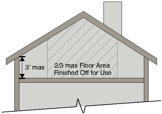
Stream. Any stream, beginning at
1) The location of a spring, seep, or groundwater outflow that sustains streamflow; or
2) A point in the stream channel with a drainage area of 25 acres or more; or where evidence indicates the presence of a stream in a drainage area of other than 25 acres, the UDO Administrator may require field studies to verify the existence of a stream.
Stream bank. The sloping land that contains the stream channel and the normal flows of the stream.
Stream channel. The portion of a watercourse that contains the base flow of the stream.
Street. A public or private thoroughfare which affords the principal means of access to abutting property.
Street line. A dividing line between a lot, tract or parcel of land and a contiguous street.
Streets and alleys. A way for vehicular traffic, whether designated as a street, highway, thoroughfare, parkway, throughway, road, avenue, boulevard, lane, place or however otherwise designated, as follows:
1) Arterial streets and highways are those which are used primarily for fast or heavy traffic.
2) Collector streets are those which carry traffic from minor neighborhood streets to the major system of arterial streets and highways, including the principal entrance streets of a residential development and streets for circulation within such a development.
3) Minor streets are those which are used primarily for access to the abutting properties.
4) Marginal access streets are minor streets which are parallel to and adjacent to arterial streets and highways, and which provide access to abutting properties and protection from through traffic.
5) Alleys are minor ways which are used primarily for vehicular service access to the back or the side of properties otherwise abutting on a street.
Structure. Anything constructed or erected, the use of which requires a location on the ground, or attached to something having a location on the ground, including, but not limited to, manufactured homes, gas or liquid storage tanks, signs, billboards, backstops for tennis courts, fences or radio towers.
Structural alterations. Any change in the supporting members of a building, such as bearing walls, columns, beams or girders, or any substantial changes in the roofs or exterior walls.
Structural erosion, sedimentation and pollution control practices. Practices for the stabilization of erodible or sediment-producing areas by utilizing the mechanical properties of matter for the purpose of either changing the surface of the land or storing, regulating or disposing of runoff to prevent excessive sediment loss. Examples of structural erosion and sediment control practices are riprap, sediment basins, dikes, level spreaders, waterways or outlets, diversions, grade stabilization structures, sediment traps, etc. Such practices can be found in the publication manual for erosion and sediment control in Georgia.
Structural stormwater control. A structural stormwater management facility or device that controls stormwater runoff and changes the characteristics of that runoff including, but not limited to, the quantity and quality, the period of release or the velocity of flow of such runoff.
Subdivider. Any person who undertakes the subdivision of land.
Subdivision, major. The division of a tract or parcel of land into four or more lots which may or may not involve the construction of a new public or private street; or any subdivision that involves the construction of a new public or private street. Because major subdivisions involve construction of a new public or private street or the upgrade of an existing private access way to City standards, construction plans and development permits are required, and major subdivisions are therefore processed in multiple steps including preliminary plat approval (unless specifically exempted), approval.
Subdivision, minor. A subdivision of four or fewer lots, which does not involve the construction of a new public or private street. Because minor subdivisions do not involve the construction of a new public or private street, they are processed administratively by the UDO Administrator as final plat applications that do not require preliminary plat approval. Any improvements to an existing public street abutting the tract proposed for minor subdivision, or the installation of utilities along said existing public road, as may be required to comply with this ordinance, shall be done according to plans and permit requirements of this UDO, but said requirements shall not subject the minor subdivision to the requirements for a major subdivision as specified in this UDO.
Substantial damage. Damage of any origin sustained by a structure whereby the cost of restoring the structure to its before damaged condition would equal or exceed 50 percent of the market value of the structure before the damage occurred.
Substantial improvement (zoning). For the purposes of zoning, substantial improvement means any combination of repairs, reconstruction, alteration or improvements to a building where the cost of the construction exceeds 50 percent of the fair market value of the structure prior to the improvement. Determination of fair market value is based on the applicant's submittal of either the existing records of the DeKalb County tax assessor or a current appraisal of the structure's value. The cost of the proposed construction shall be determined by the applicant using detailed, complete (turnkey) contracts from a qualified state licensed contractor or by using published standardized construction value data published by the International Code Council (ICC). Values for the purpose of this definition are exclusive of land values.
Substantial improvement (floodplain). For the purposes of floodplain protection, substantial improvement any combination of repairs, reconstruction, alteration, or improvements to a building, taking place during a ten-year period, in which the cumulative cost equals or exceeds 50 percent of the market value of the structure prior to the improvement. The market value of the building means: (1) the appraised value of the structure prior to the start of the initial repair or improvement, or (2) in the case of damage, the value of the structure prior to the damage occurring. This term includes structures which have incurred "substantial damage" regardless of the actual amount of repair work performed. For the purposes of this definition, "substantial improvement" is considered to occur when the first alteration of any wall, ceiling, floor, or other structural part of the building commences, whether or not that alteration affects the external dimensions of the building. The term does not, however, include those improvements of a building required to comply with existing health, sanitary, or safety code specifications which are solely necessary to assure safe living conditions, which have been pre-identified by the building official or other code enforcement official, and not solely triggered by an improvement or repair project.
Substantial renovation. Repairs and alterations to a structure the total cost of which exceeds 30 percent of the fair market value of the property as shown on the then current property tax records of the City.
Substantially improved existing manufactured home park or subdivision. Where the repair, reconstruction, rehabilitation or improvement of the streets, utilities and pads equals or exceeds 50 percent of the value of the streets, utilities and pads before the repair, reconstruction or improvement commenced.
Swimming pool. A structure intended for swimming or recreational bathing that can hold water over 24 inches deep. This includes in-ground, above-ground, and on-ground swimming pools, hot tubs, and spas.
T
Telecommunication antenna. Any exterior transmitting or receiving devices mounted on a tower, building or structure and used in communications that radiate or capture electromagnetic waves, digital signals, analog signals, radio, wireless telecommunications signals or other communications signals. Such definition does not include, for purposes of this Article, radar antennas, amateur radio antennas, satellite earth stations, MMDS antennas, television receiving antennas and direct broadcast satellite dishes.
Telecommunication tower. Any structure that is designed and constructed primarily for the purpose of supporting one or more antennas, including self-supported or monopole towers. The term includes radio and television transmission towers, microwave towers, common-carrier towers, and cellular telephone or PCS towers.
Temporary sign. Any non-illuminated sign, banner, or advertising display constructed of cloth, canvas, light materials, with or without frames and intended to be displayed for a brief and limited period of time, not to exceed 30 days. Construction signs, real estate and residential real estate signs are not considered temporary signs within this definition.
Tobacco paraphernalia. Any equipment, device, or instrument that is primarily designed or manufactured for the smoking, chewing, absorbing, dissolving, inhaling, snorting, sniffing, or ingesting by any other means into the body, of tobacco, tobacco products, alternative nicotine products, and/or consumable vapor products, as defined in O.C.G.A. § 48-11-1. Items or devices classified as tobacco paraphernalia include, but are not limited to, the following: pipes, punctured metal bowls, bongs, water bongs, electric pipes, e-cigarettes, e-cigarette juice, buzz bombs, vaporizers, hookahs, and devices for holding burning material.
Tobacco products. Any product in leaf, flake, plug, liquid (such as e-cigarette liquid), or any other form, derived from the tobacco or hemp plant, which is intended to enable human consumption of the tobacco or nicotine in the product, whether smoked, chewed, absorbed, dissolved, inhaled, snorted, sniffed, or ingested by any other means.
Toilet. Any fixture consisting of a water flushed bowl with a seat, used for the disposal of human waste.
Total area. The horizontal plane area described in square feet (or acres) determined by accurate boundary survey and exclusive of that area within the boundaries of any given lot or lot of record, wherein the surface condition of the land is unusable. Unusable under the meaning of this UDO shall include:
1) Land sloping steeper than 30 degrees from the horizontal;
2) Land so separated as to be unreachable by normal pedestrian access; and
3) Land subject to flooding.
Tower Height. Distance measured from the finished grade of the parcel to the highest point on the tower or other structure, including the base pad and any antenna.
Trade, vocation, business school. An educational use not operated by the DeKalb County Board of Education and having a curriculum devoted primarily to business (including barbers and beauticians), industry, trade or other vocational-technical instruction.
Transparency. See Section 2.1.8.
Travel trailer. A vehicular, portable structure built on a chassis, designed to be used as a dwelling for travel, recreational and vacation uses, permanently identified as a travel trailer by the manufacturer of the trailer, and, when equipped for the road, having a body width not exceeding eight feet, provided its gross weight does not exceed 4,500 pounds, provided its body length does not exceed 30 feet.
TRAQ Certified Arborist. A certified arborist that is "tree risk assessment qualified" (TRAQ) by the International Society of Arboriculture.
Tree. A woody plant, usually single-stemmed (but may be multi-stemmed), with the potential to grow to a mature size of at least three inches DBH and 15 feet in height.
Tree canopy cover. The amount of ground area directly beneath a tree's crown or the combined crowns of a stand of trees, measured in square feet.
Tree conservation plan. A plan submitted with any application for a tree disturbance or site development permit which shall include all information appropriate to the situation and as described in the administrative standards. A plan may include, but is not limited to; documenting the location of all protected trees, existing and proposed structures and utility infrastructure, site grading and construction proposals, methods of tree protection, tree canopy cover including proposed conserved and planted trees, and associated details as required by the tree ordinance
Tree disturbance. Any land disturbance activity that has the potential to change the characteristics of the soil, vegetation, growing space or environment within a tree protection zone or any activity that has the potential to damage a protected tree's roots, trunk or crown.
Tree disturbance permit. A permit granted to disturb the soil, vegetation, growing space or environment within the tree protection zone or damage a tree's roots, trunk or crown.
Tree impact. Any tree disturbance that proposes or has the potential to affect 20 percent or more of the tree protection zone.
Tree ordinance.Section 9.1. of this UDO was formerly known as the Tree Ordinance.
Tree protection zone. The area encompassing the entirety of a protected tree, including the soil to a depth of three feet within the critical root zone and the tree's trunk and crown.
Tree removal permit. A permit required to remove a protected tree.
Tree save area. An area designated for the purpose of meeting tree density requirements, saving natural trees and/or preserving natural buffers.
Tree spade. A tree spade is a specialized machine that mechanizes the transplanting of large trees. A typical machine consists of 3 or 4 that encircle the tree, digging into the ground and then lifting the entire tree, including its roots and soil (in what is termed a "root ball"[1]), out of the ground and replanting or transplanting the whole tree in a designated area. Tree spades are available in a wide variety of sizes and designs that are made to suit varied soil conditions and customer requirements.
Trophic layer. The different levels of low-growing grasses, forbs (non-woody flowering plants other than grass) and other plants; small trees, bushes and/or shrubs; and canopy cover from medium to larger trees existing in a stream buffer.
Trout streams. All streams or portions of streams within the watershed as designated by the Wildlife Resources division of the Georgia Department of Natural Resources under the provisions of the Georgia water quality control act, O.C.G.A. § 12-5-20, In the rules and regulations for water quality control, chapter 391-3-6 at www.Gaepd.Org. Streams designated as primary trout waters are defined as water supporting a self-sustaining population of rainbow, brown or brook trout. Streams designated as secondary trout waters are those in which there is no evidence of natural trout reproduction, but are capable of supporting trout throughout the year. First order trout waters are streams into which no other streams flow except springs.
Trunk. The woody stem of a tree that extends from the root flare into the crown, supports the crown, and functions in the transport of water and nutrients to the limbs and leaves.
Two-family dwelling. Two dwelling units in a single principal structure.
U
UDO Administrator. The City Manager or the City Manager's designee.
Understory tree. A tree that grows beneath a canopy or overstory tree and will generally reach a mature height less than 40 feet.
Unenclosed. Located entirely outside of a building or structure, or includes a barrier on two sides or less, with or without a solid roof cover, or includes a barrier on three sides without a solid roof cover.
Urban agriculture. The use of a lot for the cultivation of food and/or horticultural crops, beekeeping, composting, animal husbandry, and/or aquaculture. Such use may include on-site sales where retail uses are allowed, and is not intended to include cultivation for personal consumption or use.
Urinal. Any fixture consisting of a water flushed bowl used for the disposal of human waste.
USGBC. The United States Green Building Council, a nonprofit organization comprised of leaders from the building industry formed to encourage sustainability by promoting buildings that are environmentally responsible, profitable, and healthy places to live and work.
Utility trailer. A trailer so designed or constructed to permit the hauling of various type items, goods, materials or other objects.
V
Variance. A grant of relief from the requirements of this article which permits construction in a manner otherwise prohibited by this UDO.
Vegetative erosion and sedimentation control measures. Measures for the stabilization of erodible or sediment-producing areas by covering the soil with:
1) Permanent seeding, sprigging or planting, producing long-term vegetative cover; or
2) Temporary seeding, producing short term vegetative cover; or
3) Sodding, covering areas with a turf of perennial sod-forming grass.
Such measures can be found in the publication manual for erosion and sediment control in Georgia.
Vehicle rental. A facility that rents motor vehicles for short periods of time (generally ranging from a few hours up to two weeks) for a fee.
Vehicle sales. See Section 6.5.13.
Vehicle sales or leasing. A facility where a manufacturer-authorized business or dealer engages in the sale or lease of new and used motor vehicles.
Vehicle service, repair. See Section 6.5.12.B.
Vehicular business. A business that, due to the nature of the product or service offered is oriented toward persons using vehicular transportation. Such businesses may include automotive service stations and repair shops, motor or drive-in banks, drive-in eating establishments, automobile dealers, drive-in laundries and dry cleaning establishments, motels, grocery and convenience stores, and similar establishments, but do not include general business offices, professional offices, contractor's offices, printer's shops, real estate or insurance offices, retail and other business without drive-in, drive-through or dedicated customer parking facilities, or similar establishments.
Veterinary hospital. A building or establishment where the principal service is the medical treatment of animals. For the purposes of this UDO, this definition does not include a kennel.
Violation. The failure of a structure or other development to be fully compliant with the community's floodplain management regulations. A structure or other development without the elevation certificate, other certificates, or other evidence of compliance required in this UDO is presumed to be in violation until such time as that documentation is provided.
W
Walk up flat. A building designed to accommodate 3 or 4 principal dwelling units. Walk up flats shall mean developed land containing 3 or 4 residential units vertically and horizontally integrated on a single individual lot.
Wall, Exterior. The external wall of a unit.
Wall, Interior. An external or internal wall of a unit that lies between two attached units (such as an attached house or townhouse).
Wall plate. A horizontal member situated along the top of a wall at the level of the eaves for bearing the ends of joists or rafters.
Wall plate height. Height, as measured to the top of the wall plate.
Wall sign. A sign applied to or mounted on the wall or surface of a building or structure, the display surface of which is parallel to the supporting surface or perpendicular to the supporting surface.
Warehouse and distribution. See Section 6.6.5.
Watercourse. Any natural or artificial watercourse, stream, river, creek, channel, ditch, canal, conduit, culvert, drain, waterway, gully, ravine, or wash in which water flows either continuously or intermittently and which has a definite channel, bed and banks, and including any area adjacent thereto subject to inundation by reason of overflow or floodwater.
Watershed. The land area that drains into a particular stream.
Weekend directional sign. A temporary directional sign used to direct motorists and others to a property for sale or lease, community event, yard or garage sale, or similar place or event. Such signs are allowed on weekends only between the hours of 5:00 P.M. On Friday to 11:59 P.M. on Sunday.
Wetlands. Those areas that are inundated or saturated by surface or ground water at a frequency and duration sufficient to support, and that under normal circumstances do support a prevalence of vegetation typically adapted for life in saturated soil conditions.
Wetlands generally include swamps, marshes, bogs and other similar areas.
Window sign. A sign painted on, applied to or hung on the inside of a window.
Wireless transmission facilities. The buildings, cabinets, equipment and property, including but, not limited to, generating and switching stations, repeaters, cables, wires, conduits, ducts, pedestals, antennas, towers, alternative tower structures, electronics and other appurtenances used to transmit, receive, distribute, provide or offer low-power mobile voice transmission, data transmission or other wireless communications by linking a wireless network of radio wave transmitting devices through a series of short range, contiguous cells that are part of an evolving cell grid.
X
Y
Yard. An open space between a building or use and the joining lot lines, unoccupied and unobstructed from the ground upward, except as otherwise provided in Section 2.1.5. In measuring a yard for the purpose of determining the width of a side yard, the depth of a front yard or the depth of a rear yard, the minimum distance between the lot line and the main building shall be used.
Yard, front. A yard extending across the front of a lot between the side lot lines. On corner lots the front yard shall be considered as parallel to the street upon which the lot has its least dimension.
Yard, rear. A yard extending across the rear of a lot between the side lot lines. On all lots the rear yard shall be in the rear of the front yard.
Yard, side interior. A yard between the main building and the side lot line and extending from the required front yard to the required rear yard.
Z
Zoning Administrator. The City Manager or the City Manager's designee.
Zoning district. The use classification of parcels or tracts of land as described and defined by the City zoning ordinance.
Zoning ordinance. The zoning and land use regulations adopted for use within the City that constitute a zoning ordinance within the meaning of O.C.G.A. §§ 36-66-1 et seq., as specified in Section 1.1.4.
(Ord. No. O-15-Z-01, §§ 1.14, 1.15, 1-20-15; Ord. No. O-16-Z-09, § 2.1, 6-20-16; Ord. No. O-17-02, § II, 3-20-17; Ord. No. O-17-09, §§ 7.1, 7.2, 6-9-17; Ord. No. O-17-13, § 2, 12-18-17; Ord. No. O-18-Z-17, § 4, 5-21-18; Ord. No. O-19-13, 8-5-19; Ord. No. O-19-16, § 2, 9-16-19; Ord. No. O-20-Z-01, § 3, 7-20-20; Ord. No. O-20-17, Att., 12-10-20; Ord. No. O-22-Z-02, §§ 1, 2, 1-18-22; Ord. No. O-22-11, § 3(Exh. B), 10-17-22; Ord. No. O-22-Z-08, § 2, 10-17-22; Ord. No. O-23-Z-01, § 19, 2-6-23; Ord. No. O-24-Z-04, § 3.1, 5-20-2024; Ord. No. O-24-Z-05, § 4.1, 5-20-2024; Ord. No. O-24-Z-06, § 3.1, 5-20-2024)