
Decatur City Zoning Code
ARTICLE 9
- Environmental Protection
Sec. 9.1.- Tree Canopy Conservation[2]
Editor's note— Ord. No. O-22-Z-01, § 1, adopted Jan. 18, 2022, repealed the former Sec. 9.1, §§ 9.1.1—9.1.19, and enacted a new Sec. 9.1 as set out herein. The former Sec. 9.1 pertained to tree protection and derived from Ord. No. O-15-01, § 1, adopted Jan. 20, 2015.
Sec. 9.4. - Soil Erosion and Sedimentation Control[3]
Editor's note— Ord. No. O-19-16, § 1, adopted Sep. 16, 2019, amended § 9.4 in its entirety to read as herein set out. Former § 9.4, §§ 9.4.1—9.4.10, pertained to the same subject matter.
Sec. 9.5 - Floodplain Management/Flood Damage Prevention[4]
Editor's note— Ord. No. O-19-13, adopted Aug. 5, 2019, amended § 9.5 in its entirety to read as herein set out. Former § 9.5, §§ 9.5.1—9.5.8, pertained to the same subject matter.
9.1.1. - Intent
A.
The purposes of these regulations are to encourage the conservation of existing tree canopy and provide minimum requirements for the protection, maintenance, renewal, and increase of tree canopy cover across the City. The City believes that trees are an essential part of the community's infrastructure and recognizes that they provide measurable and valuable services and benefits to our community. These services and benefits include:
1.
Improved health of Decatur's citizens and visitors;
2.
Improved air quality;
3.
Improved water quality;
4.
Improved soil quality;
5.
Storm water control;
6.
Energy conservation;
7.
Increased property values;
8.
Habitat for desirable wildlife;
9.
Noise and glare buffering;
10.
Privacy screening;
11.
Increased community aesthetics and quality of life;
12.
Increased shade for active living activities like walking, and biking;
13.
Mitigating the urban heat island effect;
14.
Implementing the City's sustainability goals, including resilience, climate change mitigation and adaptation.
B.
The City recognizes that trees and tree canopy are a community resource that requires active conservation and replanting efforts. The City's tree canopy goal is a minimum of 65% canopy coverage over the entire City of Decatur. The City's tree canopy cover shall be measured every 5 years. Future canopy measurements will use methodologies substantially similar to the "Urban Tree Canopy Assessment and Change Analysis 2009-2019" completed in 2021. The City shall review this Section following each canopy assessment to support canopy goals.
C.
The City Arborist shall prepare and publish a report at the end of each calendar quarter which shall summarize tree removals, tree replacement, and additional tree plantings. Such report shall include location, size in diameter at breast height (DBH), caliper and canopy cover as appropriate, reason for removal or planting and other information as may be necessary to measure the effectiveness of the City's tree ordinance.
D.
Within one year of adoption of this Section, the City Arborist shall hold two (2) public information meetings to disseminate information regarding compliance with this Section for tree care companies, property owners and managers, and residents. Thereafter, an annual public information meeting shall be held, providing the public with information on best compliance practices and recent developments under this Section.
(Ord. No. O-22-Z-01, § 1, 1-18-22)
9.1.2. - Applicability And Exemptions
A.
This Section applies to any and all real property within the City limits, including all public and private property and all zoning districts.
B.
This Section shall apply to all protected trees as defined herein.
C.
No protected tree shall be removed, destroyed, or disturbed without the written consent of the City Arborist in the form of an approved Tree Conservation Plan or Tree Removal Permit.
D.
The following activities and trees are exempt from compliance with this Section:
1.
Activities or trees included in approved community forest management plans, annual utility work plans, memoranda of understanding or other plans and agreements approved and executed by the City Manager and government entities, utility companies, public authorities, boards or commissions, provided that such activities comply with the tree protection measures described in this Section.
2.
Activities or trees described in a waiver issued by the City Manager during and immediately after the period of an emergency such as a flood, ice storm, thunderstorm, windstorm, tornado, or any other disastrous act of nature.
3.
Activities or trees on any portion of a property included within the limits of a valid site development permit issued prior to March 21, 2022, provided that all time constraints relating to the permit are observed.
4.
Expedited written authorization may be given by the City Arborist for a tree to be removed with a Tree Removal Permit required to be submitted within 72 hours of the removal in a case where a tree has been determined by a Certified Arborist using the I.S.A. Tree Risk Assessment Form to be in the following condition:
a.
To be at moderate or higher risk of failure with a target present and such risk cannot otherwise be mitigated to an acceptable level as determined by the property owner or to have a high to extreme risk of failure that cannot otherwise be mitigated.
b.
To be in such a dangerous condition that it is threatening public health, safety or welfare or threatens to cause imminent harm to a building or other infrastructure, and such tree requires immediate removal. A request for expedited written authorization of tree removal shall include the location, size, species, and description of the condition of the tree to be removed.
5.
Trees grown specifically for sale, such as Christmas trees and nursery stock.
E.
Special exceptions to canopy coverage standards for affordable housing. The City Commission may authorize special exceptions to the requirements of this Section when public purposes are met and such exceptions support the community goal of affordable housing. Such exceptions shall be considered for permanent, bona fide affordable housing and subject to such standards, limitations and conditions as determined by the City Commission.
(Ord. No. O-22-Z-01, § 1, 1-18-22)
9.1.3. - Administrative Standards and Supplemental Materials
A.
Administrative Standards: Administrative standards, which provide detailed information on how this Section shall be administered and implemented, are hereby established and incorporated by reference herein. Upon approval of the UDO Administrator, the City Arborist may waive or modify administrative standards to respond to a bona fide hardship based on criteria described in the administrative standards.
B.
Tree Species List: There is hereby established a City Tree Species List that is included in the Administrative Standards and is hereinafter referred to as the Tree Species List.
(Ord. No. O-22-Z-01, § 1, 1-18-22)
9.1.4. - Tree Canopy Cover Credit
A.
Unless otherwise specified in this Section, actual tree canopy cover may be supplemented with tree canopy cover credit as defined in this section.
B.
All existing healthy trees greater than 4 inches DBH, with the exception of invasive and non-native, flowering ornamental species, that are rated fair or better shall be eligible for tree canopy cover credit. Poor-rated trees shall not be eligible for tree canopy cover credit. Trees whose crown and/or trunk are adversely impacted by invasive species including, but not limited to, English ivy, wisteria, kudzu and other species detrimental to tree health shall receive no tree canopy cover credit until such invasive species are removed.
C.
The area of tree canopy cover on a site shall be measured as the percent of the lot area that is covered by tree canopy, including canopy that projects over buildings and impervious surfaces. The portion of canopy projected over and onto the applicant's property by a boundary tree located on the property line or by a tree located on public property shall be included in the measurement of total tree canopy cover existing on a site. Tree canopy projected by a tree located in a public right-of-way shall be included. Tree canopy projected by a tree located on the applicant's property over and onto neighboring or adjacent property shall be included. Tree canopy projected over and onto the applicant's property by a tree growing on a neighboring or adjacent property shall not be included in the tree canopy cover measurement.
D.
The amount of tree canopy cover credited to an individual or group of existing trees shall be the actual projection of the combined crowns onto the ground measured in square feet as described in the Administrative Standards. The crowns of existing understory trees as defined in the Tree Species List may be credited at half their combined crown area and included in the tree canopy cover measurement. The preservation of a tree designated as a Landmark Tree within the buildable area of a lot shall receive 1.5 times canopy credit in the calculation of existing tree canopy if 70% of the critical root area and the entire structural root plate is undisturbed. An arboricultural tree prescription from a certified arborist or registered forester will be required for this credit.
E.
New trees shall receive partial credit at the time of planting based on the tree canopy cover potential for the species at maturity as listed in the table below and the Tree Species List:
(Ord. No. O-22-Z-01, § 1, 1-18-22)
9.1.5. - Tree Canopy Cover Requirements
A.
Tree canopy cover provided by existing protected trees on March 21, 2022 shall be conserved on a property to the greatest extent possible. No disturbance or removal of existing protected trees shall be permitted without the written permission of the City Arborist in the form of an approved Tree Conservation Plan or Tree Removal Permit.
B.
Tree canopy cover conserved or planted to meet the requirements of this Section shall be conserved on the site in perpetuity unless such trees become untreatably diseased, infested, or have a moderate or higher risk rating and such risk cannot otherwise be mitigated as determined by a Certified Arborist using the I.S.A. Tree Risk Assessment. Tree canopy cover required by this Section that is lost over time shall be replaced during the first planting season (November 15—March 1) after the loss occurs.
C.
Commercial, High Density Residential, and Institutional.
1.
This subsection applies to properties in the following zoning districts: RS-17, RM-18, RM-22, RM-43, PO, C-1, C-2, C-3, MU, NMU, and I.
2.
A minimum amount of 45% tree canopy cover from trees in fair or better-rated condition shall be required on public and private properties in RS-17, RM-18, RM-22, RM-43, PO, C-1, C-2, C-3, MU, NMU, and I.
3.
For properties zoned RS-17, RM-18, RM-22, RM-43, PO, NMU and I that require a land disturbance permit or where impervious area is increased, a minimum of 50% of the existing tree canopy cover from trees in fair or better-rated condition shall be conserved. If less than 45% canopy cover exists on the site at the time of permit application, the property owner shall apply for a Tree Conservation Plan or a Tree Removal Permit using standards for Alternative Compliance (Section 9.1.6.D).
4.
For properties zoned C-1, C-2, C-3 and MU that require a land disturbance permit or where impervious area is increased and less than 45% canopy cover exists on the site at the time of permit application, the property owner shall apply for Alternative Compliance (Section 9.1.6.D).
5.
For sites where impervious cover or gross floor area is increased, the Tree Bank may be used for up to 50% of tree planting requirement.
D.
Single Family Residential
1.
This subsection applies to properties in the following zoning districts: R-85, R-60 and R-50.
2.
For properties that require a land disturbance permit or where impervious area is increased, no less than 75% of the existing tree canopy cover from trees in fair or better-rated condition shall be conserved. All tree canopy from Landmark trees (Section 9.1.15) shall be conserved. Planting of replacement trees is required to maintain no net loss of tree canopy, including at least one tree planted in the front yard of the property or in an adjacent public right-of-way.
3.
If replacement trees are required, a minimum of 50% of the property's tree canopy cover replacement must be accommodated on site, including adjacent public rights-of-way. At least one large canopy tree shall be planted in the front yard of the property or in the adjacent public right-of-way. The remaining 50% may be satisfied by a combination of replacement trees planted on City-owned property or in public rights-of-way, the installation of on-site green infrastructure, the installation of rooftop solar photovoltaic panels (PV), or, upon submission of an affidavit from the property owner attesting that other options have been explored but are infeasible due to site conditions, a payment in lieu fee made to the tree bank.
4.
A minimum amount of 60% tree canopy cover from trees in fair or better-rated condition shall be required on single-family residential properties.
E.
Properties Owned or Managed by the City of Decatur and the City Schools of Decatur
1.
Properties owned or managed by the City of Decatur or the City Schools of Decatur shall maintain no net loss of canopy, unless compliance with Section 9.1.6 is otherwise demonstrated.
(Ord. No. O-22-Z-01, § 1, 1-18-22)
9.1.6. - Tree Canopy Replacement Requirements
A.
All trees planted to meet tree canopy replacement requirements shall be 2.5" caliper or larger and shall meet ANSI Z60.1 Standards for Nursery Stock, and all planting shall be done in accordance with current ANSI A300 Standards for Tree Care Operations, ANSI Z133 Safety Standards, industry best management practices, as well as the Administrative Standards that accompany this Section. Tree replacement under this Section shall be accomplished using trees of equivalent or better ecological value and quality on the Tree Species List.
B.
A Tree Planting Plan shall be submitted along with a Tree Removal Permit application as described in the Administrative Standards.
C.
Removal of a protected tree without a valid Tree Removal Permit shall be considered a violation of this Section and subject to penalties described in Section 9.1.20.
D.
Commercial, High Density Residential, and Institutional Alternative Compliance
1.
For properties with less than 45% tree canopy cover at the time of permit application that require a land disturbance permit or where impervious area is increased, a Tree Conservation Plan is required.
2.
All existing trees in fair or better-rated condition located in public rights-of-way adjacent to the property must be conserved.
3.
Additional tree canopy cover must be planted to achieve 45% tree canopy cover across the site, including tree canopy provided by streetscape installations on public rights-of-way. If replacement trees are required, a minimum of 50% of the property's tree canopy cover replacement must be accommodated on site, including adjacent public rights-of-way. The remaining 50% may be satisfied by a combination of replacement trees planted on City-owned property or in public rights-of-way, the installation of on-site green infrastructure, the installation of rooftop solar photovoltaic panels (PV), or, upon submission of an affidavit from the property owner attesting that other options have been explored but are infeasible due to site conditions, a payment in lieu fee made to the tree bank.
E.
Green Infrastructure
1.
Green infrastructure may include, but not be limited to, bioretention, rain gardens, infiltration trenches, bioswales, permeable pavement, stormwater planters, subsurface infiltration, rainwater harvesting, cisterns, landscaped green infrastructure, and other practices as described by the EPA.
2.
No trees shall be removed for the installation of green infrastructure to satisfy the requirements of this Section.
3.
Green infrastructure installed to satisfy a portion of a property's tree canopy cover replacement requirement must not be otherwise legally required.
4.
The equivalent tree canopy cover credit of green infrastructure practices is listed in the Administrative Standards.
(Ord. No. O-22-Z-01, § 1, 1-18-22)
9.1.7. - Tree Bank
A.
There is hereby established a Tree Bank that shall receive payments made by property owners in lieu of planting additional tree canopy cover, as approved by the City Arborist, in addition to forfeited bonds and forfeited escrow funds. Funds in the Tree Bank shall be administered by the City Manager.
B.
Where it is determined by the City Arborist that it is impractical or impossible to fully meet the tree canopy cover requirements for a site, the portion of the canopy that cannot be accommodated on the site may be satisfied by a payment into the Tree Bank that shall be made prior to the issuance of a Tree Removal Permit, Building Permit, or Land Disturbance Permit. The amount of the payment shall be calculated using the standard tree canopy value listed in the City's fee schedule.
C.
The Tree Bank funds shall be available for use by the City for the establishment, maintenance, improvement, and expansion of tree canopy cover on public or private property. Funds shall not be used on private property to meet the requirements of a development project. Funds may be used on private property only to expand and improve the City's tree canopy. The expenditure of tree bank funds shall not be used for tree removal and shall be permitted for various activities related to tree conservation including, but not limited to:
1.
Purchase of trees;
2.
Planting and transplanting of trees;
3.
Maintenance of trees during the establishment period;
4.
Purchase of greenspace;
5.
Funding tree care educational programs; and
6.
Funding maintenance and arboricultural treatments of existing City-owned trees.
(Ord. No. O-22-Z-01, § 1, 1-18-22)
9.1.8. - Standard Tree Canopy Value
A.
A standard value for each square foot of tree canopy shall be established by the City for the purpose of calculating payments to the Tree Bank. The standard tree canopy value for a tree shall be determined on a square foot basis for the actual tree canopy or tree canopy cover credit for the species, whichever is greater.
B.
The standard tree canopy value shall be based on a general but reasonable estimate of the average cost for a tree that would provide comparable canopy, including shipping, labor, installation, and 3 years of maintenance.
C.
The City Arborist shall make a recommendation to the City Manager each year on the amount of the standard tree canopy value. The current standard tree canopy value shall be listed in the City's fee schedule.
(Ord. No. O-22-Z-01, § 1, 1-18-22)
9.1.9. - Tree Planting Easements
A.
The City is hereby authorized to acquire temporary easements with owners of private property for planting and transplanting of trees. Temporary easements shall be limited to 3 years and easement areas acquired shall be located in front yards and limited to only that which is necessary for the planting of trees. The easements shall provide that, after planting, the private property owners acquire ownership of the trees, will be responsible for tree maintenance, and will release and hold the City harmless from any liability arising out of or related to the planting or presence of the trees on their property.
(Ord. No. O-22-Z-01, § 1, 1-18-22)
9.1.10. - Tree Maintenance Requirements
A.
Trees planted to fulfill the requirements of this Section shall be maintained for 2 years after the date of final inspection to establish the health and growth of the tree. Should any tree die or fail within the required maintenance period, new replacement trees shall be planted. At a minimum, maintenance shall include the following: watering, mulching, training pruning, and if necessary, pest management.
B.
All protected trees shall be maintained in accordance with current ANSI A300 Standards for Tree Care Operations, ANSI Z133 Safety Standards, industry best management practices, and the Administrative Standards that accompany this Section.
C.
The permit holder shall be responsible for identifying both newly planted and existing trees to the property owner and for informing the property owner as to their proper maintenance and any required arboricultural tree prescriptions. A Tree Maintenance Agreement between the permit holder and property owner to determine responsibility for maintenance and replacement shall be submitted to the City Arborist prior to issuance of a Certificate of Occupancy and shall be included in the record set of plans for the permit.
D.
Tree Maintenance Bond
1.
Tree removal and land disturbance permit holders that are also required to have an approved Tree Conservation Plan shall furnish a 3-year tree maintenance bond or other financial security for trees planted outside the planting season (November 15—March 1), or for trees impacted beyond the approved tree plan limits. The amount of the bond shall be equal to 125% of tree removal and replacement tree planting expenses, including materials and labor.
2.
The City Arborist shall inspect planted trees and assess their health at the end of the establishment period and shall provide a written report to the permit holder indicating what actions, if any, are required before the bond will be released. If trees are found to be dead, dying, or not healthy at the time of the inspection, then replacement tree planting shall be required and the bond for replacement trees shall be retained for an additional 3 years.
(Ord. No. O-22-Z-01, § 1, 1-18-22)
9.1.11. - Tree Transplanting
A.
Any protected tree transplanted using a tree spade within the boundaries of the subject site shall be given credit at 1.5 times the actual canopy coverage. Trees transplanted to locations other than the subject site shall receive actual canopy credit.
B.
A Tree Spade Transplanting Agreement must be signed by the applicant and approved by the City Arborist prior to plan approval.
C.
Transplanting shall be performed using a tree spade of proper dimension and shall comply with the current ANSI Standard Z-60.1, Section 1.3.
D.
Protected trees shall not be transplanted during the active growing period (March 15—October 1).
(Ord. No. O-22-Z-01, § 1, 1-18-22)
9.1.12. - Canopy Loss Fee
A.
A canopy loss fee based on benefits lost to the community shall be established for the purpose of calculating payments to the Tree Bank. See Administrative Standards section X.3.
B.
A canopy loss fee shall be paid to the Tree Bank by the property owner for any protected tree that is removed.
C.
A 50% reduction in canopy loss fee is allowed on single-family residential properties where green infrastructure is installed without tree removal. See Section 9.1.6.F.
(Ord. No. O-22-Z-01, § 1, 1-18-22)
9.1.13. - Tree Protection Requirements
A.
Disturbance of up to 20% of the tree protection zone may be allowed with an approved land disturbance permit, building permit or tree conservation plan. Tree disturbance activities encroaching more than 20% of the critical root zone are prohibited without an arboricultural tree prescription and approval of the City Arborist.
B.
Land disturbance and grading on single-family residential properties (e.g., R-85, R-60, R-50) shall be limited to no more than 125% of the total lot coverage permitted by zoning regulations.
C.
Damage to be avoided within the tree protection zone shall include, but not be limited to:
1.
Land disturbance and grading;
2.
Soil compaction;
3.
Gas, liquid, or solid contamination of the soil;
4.
Application of toxic chemicals to tree roots, trunk, or crown;
5.
Crushing or cutting of tree roots;
6.
Damage resulting from grading for or installation of sod, turf, or irrigation systems;
7.
Attachment of ropes, wires, chains, nails, screws, advertising, posters, or any other objects to tree trunks or scaffold limbs of public trees;
8.
Wounding of tree roots, trunk, and scaffold limbs;
9.
Improper pruning, including topping;
10.
Trenching for pipes, conduit, underground utilities, or silt fence;
11.
Excessive heat or desiccation causing bark, wood, limb, or large-scale bud or leaf injury.
D.
During land disturbance and land development, active protection shall be required for protected trees in accordance current American National Standards Institute (ANSI) A300 Standards for Tree Care Operations, ANSI Z133 Safety Standards, industry best management practices, and the Administrative Standards that accompany this Section.
E.
Active tree protection measures shall consist of the following:
1.
Erection of tree protection fencing around the outer limits of the critical root zone to include temporary chain link fence or four foot orange tree protection fencing and staked hay bales;
2.
Posting of tree protection signs in both English and Spanish stating "Tree Protection Zone—Keep Out";
3.
Removal of invasive weeds by non-mechanical means that do not damage soil and tree roots and placement of a 2-inch layer of mulch within the critical root zone;
4.
Preconstruction limb pruning on any tree within the construction zone using ANSI Standard A300 at an appropriate height to avoid damage from construction equipment;
5.
Root pruning using ANSI Standard A300 for any non-structural roots that may be exposed during construction; cutting or damage to the structural root plate is prohibited;
6.
Installation of a temporary bridge over the root system for any tree within the tree protection zone;
7.
Avoidance of any soil disturbance or land development activities within the tree protection zone.
F.
The City Arborist may require the expansion of the critical root zone up to 20%. In no case shall land disturbance activities be conducted within 10 feet of the trunk of a protected tree.
G.
All tree protection measures shall be installed prior to land disturbance and shall be maintained until after final inspection. The City Arborist or their designated representative shall be contacted for an on-site inspection after tree protection measures are installed and prior to final landscape installation.
H.
When the City Arborist determines that significant damage has occurred to any protected tree due to either permitted or non-permitted land disturbance activities, the City Arborist shall require that the tree be treated according to professional standards to mitigate the damage.
I.
If the City Arborist determines that the tree is irreparably damaged due to land disturbance activities, the City Arborist may require that the tree be removed.
(Ord. No. O-22-Z-01, § 1, 1-18-22)
9.1.14. - Boundary Trees
A.
A Boundary Tree Agreement is required for each boundary tree when a Building Permit or Land Disturbance Permit is applied for that will impact more than 20% of the critical root zone. Applicants must submit a Boundary Tree Agreement executed by each boundary tree owner authorizing treatment or removal of any boundary tree. No boundary tree shall be removed without written permission from each boundary tree owner. Signing a Boundary Tree Agreement does not prevent an owner from pursuing additional legal remedies.
B.
Permit applicants must make and document three (3) bona fide attempts in person, by phone, or email to contact each boundary tree owner. If no response is provided, then one attempt by certified mail to each tree owner, with a waiting period of at least 3 weeks for response, is required. A copy of the certified mailing and the arboricultural tree prescription shall be received by the City Arborist prior to issuance of a Building Permit or Land Disturbance Permit.
C.
If the permit applicant is unable to obtain a Boundary Tree Agreement, then the permit application must be revised to reduce the impact to 20% or less of the critical root zone and a paid arboricultural tree prescription, treatments, and a tree bond shall be provided.
D.
A Boundary Tree Bond is required if no Boundary Tree Agreement was reached, in an amount totaling the estimated cost of removal plus the cost to replace the boundary tree's canopy cover shall be established prior to final inspection.
E.
Boundary tree health and potential for survival shall be determined by the City Arborist. If after 3 years the boundary tree is found dead or determined it be in irreversible decline as a result of the permit holder's disturbance activities, the City Arborist shall authorize the return of bond funds to the adjacent property owner of the subject boundary tree. The City Arborist may also require that the escrow account remain in place for up to an additional 2 years if signs of tree decline are evident but treatment options by the permit holder could be taken to improve tree health and longevity. If after 3 years the tree is in fair or greater condition the bond amount shall be returned to the permit holder.
F.
Neither the tree owner nor the permit holder shall be entitled to receive interest on any bond funds required by this provision. Any funds not collected by either the boundary tree owner or the permit holder within a period of 5 years shall be deposited in the tree bank.
G.
Recompense will be required at 2 times the canopy potential of the boundary tree.
(Ord. No. O-22-Z-01, § 1, 1-18-22)
9.1.15. - Landmark Trees
A.
Any tree may be considered for Landmark Tree designation, establishing it as a public landmark.
B.
Property owners may nominate qualified trees on their own property for Landmark Tree designation by written request to the City Arborist or UDO Administrator. The nomination will be reviewed by the City Arborist and presented to the City Commission for acceptance. If the nomination is approved, the Landmark Tree designation shall run with the property and the tree shall not be intentionally removed, destroyed or disturbed.
C.
Criteria for Landmark Tree designation. The tree must be free of untreatable diseases, pests and other serious injury, have a reasonable life expectancy of more than ten (10) or more years, must be free from structural defects that could present a hazard to the public, and must meet at least 2 of the following standards:
1.
The tree is demonstrated to have an association with a documented historical event or is located on an historic site;
2.
The tree has an unusually high aesthetic value;
3.
The tree is of unique or notable character because of its age, species, variety, location, or because of the size and development of its crown, trunk, or main stem;
4.
Minimum DBH of 26" for overstory or canopy trees and 10" for understory trees.
D.
Any tree designated as a Landmark Tree will be counted at 1.5 times the existing canopy. If a Landmark Tree no longer meets the Landmark Tree criteria, then a property owner may apply for a tree removal permit and provide an I.S.A. Basic Tree Risk Assessment Form completed by a certified arborist. If the UDO Administrator and if the City Arborist approve the removal request, tree canopy replacement requirements must be met (Section 9.1.6).
E.
The City Arborist shall maintain and publish a roster of Landmark trees and shall provide a current roster of Landmark trees to the City Clerk annually.
(Ord. No. O-22-Z-01, § 1, 1-18-22)
9.1.16. - Plans and Permits
A.
The following table lists plan and permit requirements by property type and activity. In the event of ambiguity or inconsistency between the table and other parts of this Section, the provision that results in the greatest protection of trees shall apply.
Permits Requirement Guide
B.
The following documents may be required prior to construction:
1.
No Tree Impact Statement
a.
A No Tree Impact Statement is required for any exterior, outdoor, or landscaping construction project where no trees over 6" diameter are proposed to be impacted.
2.
Tree Removal Permit
a.
A Tree Removal Permit is required for any removal or disturbance of a protected tree located on all public and private properties for which a Building Permit or Land Disturbance Permit is not required. Such tree shall be untreatably diseased, dead or at moderate or higher risk of failure with a target present and such risk cannot otherwise be mitigated to an acceptable level as determined by the property owner or to have a high to extreme risk of failure that cannot otherwise be mitigated.
b.
Tree planting required to achieve no net loss of canopy.
c.
A Tree Removal Permit application shall include, at minimum:
i.
Size of all impacted trees including canopy coverage utilizing the canopy measurement methodology in Section 9.1.4 and DBH.
ii.
A tree replanting plan that shall result in no net loss of canopy on the site.
iii.
A description of the need for tree removal.
d.
The amount of tree canopy cover removed from the site shall be replaced on site by trees of comparable or greater mature canopy size and species quality to maintain no net loss of tree canopy cover.
e.
A Tree Removal Permit application must be prepared by a Certified Arborist.
f.
The City Arborist is responsible for reviewing all tree removal permit applications. When reviewing an application for tree removal, the City Arborist shall consider the following factors, as applicable:
i.
Reason for removal;
ii.
Intended use of site where tree is located;
iii.
Tree species, size and condition;
iv.
Impact of planned activities on tree health and stability;
v.
Function and value of tree;
vi.
Current tree canopy cover on the site;
vii.
Impact of removal to the site;
viii.
Impact of removal to the environment;
ix.
Impact of tree on value of property;
x.
Potential for replacement of tree canopy elsewhere on the site; and
xi.
Potential for replacement of tree canopy on the public street right-of-way or other nearby public property.
g.
No Tree Removal Permit shall be granted unless the following criteria are satisfied:
i.
A complete application is received;
ii.
The City Arborist concludes in writing that removal of the tree is permissible, lawful and necessary and will comply with all applicable provisions of this Section 9.1.
iii.
In the event canopy on the site is below minimum canopy requirements, a binding, legally enforceable tree planting plan is made a condition of the permit, to bring the site into compliance with minimum canopy requirements. As a condition of each permit, monitoring and inspection reports shall be submitted to the City demonstrating compliance with Section 9.1.10, above, not less than annually for three years after planting. The City Arborist shall review all monitoring and inspection reports of all tree plantings made under the authority of this subsection.
3.
Tree Conservation Plan
a.
A conference with the City Arborist is required prior to the submittal of a Tree Conservation Plan or an application for a Land Disturbance or Building Permit sought for any proposed improvement or project that could result in tree disturbance or removal or that would alter soils within the critical root zone of any protected tree. The purpose of the conference is to discuss the objectives and requirements of the tree ordinance and opportunities to preserve existing trees before starting any planning for land disturbance or physical improvements. The conference shall be summarized via a written alternatives analysis submitted with the application.
b.
A Tree Conservation Plan must be submitted with all Land Disturbance and Building Permit applications for any proposed improvement or project that could result in tree disturbance or removal or that would alter soils within the critical root zone of any protected tree. No Land Disturbance or Building Permit shall be issued without an approved Tree Conservation Plan.
c.
A Tree Conservation Plan must be prepared and certified by a registered forester, registered landscape architect, or certified arborist. Tree Ratings shall be done by a certified Arborist or a Registered Forester.
d.
Upon submittal, the Tree Conservation Plan shall be reviewed by the City Arborist and either approved or returned with comments explaining the changes necessary for compliance with this Section. Corrections to be made or reasons for denial shall be noted on the plan, or otherwise stated in writing to the applicant.
e.
A Tree Conservation Plan shall include the following:
i.
Existing and proposed tree canopy cover for the site, including the percentage of canopy conserved and the percentage of canopy planted;
ii.
Type and extent of proposed soil disturbance;
iii.
Percentage of critical root zone (measured at 1.25 x DBH) to be disturbed;
iv.
Tree survey including all trees 6" DBH or larger with size, species, location, and Tree Rating;
v.
Protection, impaction, and arboricultural tree prescription measures for all trees to be conserved;
vi.
For R-50, R-60 and R-85-zoned properties, tree replacement plan to maintain no net loss of canopy, including species, caliper and location.
f.
No Tree Conservation Plan shall be approved unless the following criteria are satisfied:
i.
A pre-application conference is completed and documented via submittal of a written alternatives analysis, and a complete application is received;
ii.
The City Arborist concludes in writing that removal of the tree is permissible, lawful and necessary and will comply will all applicable provisions of this Section 9.1.
iii.
In the event canopy on the site is below minimum canopy requirements, a binding, legally enforceable tree planting plan is made a condition of the permit, to bring the site into compliance with minimum canopy requirements.
g.
Full compliance with an approved Tree Conservation Plan and tree protection measures shall be required and maintained during all phases of construction and prior to the issuance of a Certificate of Occupancy. As a condition of each permit, monitoring and inspection reports shall be submitted to the City demonstrating compliance with Section 9.1.10, above, not less than annually for three years after planting. The City Arborist shall review all monitoring and inspection reports of all tree plantings made under the authority of this subsection. If the City Arborist determines that tree disturbance results in the substantial damage, decline or death of a protected tree within 3 years after project completion, the removal of the dead or declining tree and replacement of the tree canopy cover shall be required of the permit holder.
C.
Public Notice. Upon issuance of a tree removal permit or approval of a tree conservation plan, the applicant shall post a permit placard on the property identifying the location and species of tree(s) affected.
D.
Relationship to other law. Unless considered as part of the variance application, approval of a stream buffer or zoning variance shall not be deemed an exemption to full compliance with this Section. Any project or activity undertaken in connection with receipt of a stream buffer variance or zoning variance must independently comply with all provisions of this Section.
(Ord. No. O-22-Z-01, § 1, 1-18-22)
9.1.17. - Surface Parking Lots
A.
New surface parking lots containing 8 or more spaces or any land development or redevelopment that results in the removal and replacement of 50% or more of an existing parking lot of 8 or more spaces, other than routine maintenance of the parking lot surface, shall be subject to the requirements of this Section. New trees planted in parking lots may be counted toward tree replacement requirements.
B.
Surface parking lots in commercial, institutional, and high-density residential zoning districts shall maintain 45% tree canopy cover. At least 10% of the required canopy cover must be placed within the interior of the parking lot in landscaped areas.
C.
A minimum of 1 large or medium canopy tree shall be required for every 8 parking spaces. All landscape islands shall include at least 1 canopy tree. Only those species approved for parking lots as listed in the Tree Species List shall be planted within parking lots, unless other species are approved by the City Arborist on a case-by-case basis.

(Ord. No. O-22-Z-01, § 1, 1-18-22)
9.1.18. - Administrative Setback Adjustments for Tree Conservation
A.
Minimum front, side, and rear yard setbacks for single-family residential properties may be reduced by up to 50% of the setback with the approval of the UDO Administrator where the City Arborist determines such reduction is necessary to preserve good or higher rated trees and their existing soils. Such Administrative Tree Setback Adjustments are limited to one per property per building project in any five year period.
B.
Appropriate conditions to the Administrative Tree Setback Adjustment shall be imposed to ensure the continued health of subject trees following the granting of such adjustments, including mandatory replacement requirements if the tree were to fail.
C.
Appeals of final decisions of the City Arborist regarding requests for Administrative Tree Setback Adjustments may be taken as provided in Section 9.1.21.
(Ord. No. O-22-Z-01, § 1, 1-18-22)
9.1.19. - Utility Company Requirements
A.
All utility companies shall be required to submit an annual work plan to the City Arborist by December 1 each year for the following calendar year showing the proposed location, extent and type of work to be performed, type of tree disturbance that will occur and tree protection measures to be installed to minimize tree impact. The annual work plan shall include a list of subcontractors with names, addresses and City business license numbers. No work within the tree protection zone shall be performed until the annual work plan has been received by the City Arborist.
B.
When changes are required to the annual work plan, notice in writing shall be submitted to the City Arborist for approval prior to the changes taking place. These changes may include, but are not limited to, utility infrastructure installation, repair, and tree removal or disturbance not described in the annual work plan.
C.
All work to be performed on or around protected trees shall be done in accordance with current ANSI A300 Standards for Tree Care Operations, ANSI Z133 Safety Standards, industry best management practices, and the Administrative Standards that accompany this Section.
D.
All tree pruning shall be supervised by a Certified Arborist. Pruning cuts shall be made in accordance with ANSI standards. Topping, tipping or heading cuts, flush cuts, and stub cuts shall be prohibited. No climbing spurs or spikes shall be used in trees, except when trees are to be removed or in cases of a public safety emergency, natural disaster or aerial rescue of personnel.
E.
For installation of underground utility conduit, cable, and similar utility lines, directional boring, tunneling, or air excavation tool trenching shall be required in the canopy dripline of any fair or better-rated tree. Poor-rated, untreatably diseased or infested trees should be removed prior to commencement of work. A Tree Removal Permit is required and removal must be approved by the City Arborist. A tree maintenance bond will be required for any utility work proposed in the critical root zone of an existing moderate or higher rated tree located in a right-of-way or on public property.
(Ord. No. O-22-Z-01, § 1, 1-18-22)
9.1.20. - Violations and Penalties
A.
Violations of this Section may result in the withholding of a Certificate of Occupancy, revocation or revision of a permit, issuance of a stop work order, and/or issuance of a court citation. Upon notification of a violation, a stop work order shall be issued and remain in effect until the violation is addressed. Examples of violations include, but are not limited to:
1.
Protected tree removal without a Tree Removal Permit;
2.
Soil disturbance or land development without a Land Disturbance Permit or approved Tree Conservation Plan;
3.
Violation of the conditions of a Land Disturbance Permit or approved Tree Conservation Plan;
4.
Improperly installed or maintained tree protection; and
5.
Unauthorized encroachment of a tree protection zone.
B.
When the City Arborist determines that significant damage has occurred to any protected tree due to either permitted or non-permitted land disturbance activities, the City Arborist may require that the tree be treated by a Certified Arborist according to professional standards to mitigate the damage.
C.
If the City Arborist determines that a tree is irreparably damaged due to land disturbance activities performed without a Land Disturbance Permit or in violation of the conditions of a Land Disturbance Permit or approved Tree Conservation Plan, the City Arborist shall require that the tree be removed. Such requirement is independent of any penalties, punishment or mitigation requirements imposed by the Municipal Court.
D.
When it is deemed necessary because of continued or repeated violations, the UDO Administrator may require a performance bond to ensure compliance with the provisions of this Section.
E.
Any person guilty of a violation of this Section shall be punished as provided in Section 1-12 of the Code of Ordinances. In addition to such penalties or in lieu thereof, the Municipal Court may require mitigation in the form of tree replacement, including up to twice the tree canopy cover of the removed tree, canopy loss fees and/or payments to the Tree Bank for replacement of tree canopy cover.
(Ord. No. O-22-Z-01, § 1, 1-18-22)
9.1.21. - Appeals
A.
Any person aggrieved by a decision of the City Arborist relating to the application of this Section may appeal in writing to the UDO Administrator. Such appeal shall be filed within 30 days of the date of the written decision of the City Arborist being appealed and shall specify the grounds for appeal. The UDO Administrator shall provide a decision, in writing, within 30 days of the receipt of the written appeal.
B.
Any person aggrieved by the decision of the UDO Administrator may file an appeal to the Zoning Board of Appeals pursuant to the provisions of Section 11.2.10.
(Ord. No. O-22-Z-01, § 1, 1-18-22)
9.2.1. - Description
This Section establishes the requirement for protective buffer zones for streams within the City, as well as the requirements that minimize land development within those buffers. It is the purpose of these buffer zone requirements to protect and stabilize stream banks, protect water quality and preserve aquatic and riparian habitat.
9.2.2. - Findings and Purposes
A.
Findings
Whereas, the City Commission finds that buffers adjacent to streams provide numerous benefits including:
1.
Protecting, restoring and maintaining the chemical, physical and biological integrity of streams and their water resources;
2.
Removing pollutants delivered in urban storm-water;
3.
Reducing erosion and controlling sedimentation;
4.
Protecting and stabilizing stream banks;
5.
Providing for infiltration of stormwater runoff;
6.
Maintaining base flow of streams;
7.
Contributing organic matter that is a source of food and energy for the aquatic ecosystem;
8.
Providing tree canopy to shade streams and promote desirable aquatic habitat;
9.
Providing riparian wildlife habitat;
10.
Furnishing scenic value and recreational opportunity; and
11.
Providing opportunities for the protection and restoration of greenspace.
9.2.3. - Purposes
It is the purpose of this Section to protect the public health, safety, environment and general welfare; to minimize public and private losses due to erosion, siltation and water pollution; and to maintain stream water quality by provisions designed to:
A.
Create buffer zones along the streams of the City for the protection of water resources; and
B.
Minimize land development within such buffers by establishing buffer zone requirements and by requiring authorization for any such activities.
9.2.4. - Applicability
This Section shall apply to all land development activity on property containing a stream protection area as defined in Article 12. These requirements are in addition to, and do not replace or supersede, any other applicable buffer requirements established under state law and approval or exemption from these requirements do not constitute approval or exemption from buffer requirements established under state law or from other applicable local, state or federal regulations.
A.
Grandfather Provisions
This Section shall not apply to the following activities:
1.
Work consisting of the repair or maintenance of any lawful use of land that is zoned and approved for such use on or before March 15, 2004.
2.
Existing development and on-going land disturbance activities including but not limited to existing agriculture, silviculture, landscaping, gardening and lawn maintenance, except that new development or land disturbance activities on such properties will be subject to all applicable buffer requirements.
3.
Any land development activity that is under construction, fully approved for development, scheduled for permit approval or has been submitted for approval as of March 15, 2004.
4.
Land development activity that has not been submitted for approval, but that is part of a larger master development plan, such as for an office park or other phased development that has been previously approved as of March 15, 2006.
B.
Exemptions
The following specific activities are exempt from this Section. Exemption of these activities does not constitute an exemption for any other activity proposed on a property.
1.
Activities for the purpose of building one of the following:
a.
A stream crossing by a driveway, transportation route or utility line;
b.
Public water supply intake or public wastewater outfall structures;
c.
Intrusions necessary to provide access to a property;
d.
Public access facilities that must be on the water including boat ramps, docks, foot trails leading directly to the river, fishing platforms and overlooks;
e.
Unpaved foot trails and paths;
f.
Activities to restore and enhance stream bank stability, vegetation, water quality or aquatic habitat, so long as native vegetation and bioengineering techniques are used.
2.
Public sewer line easements paralleling the creek, except that all easements (permanent and construction) and land disturbance should be at least 25 feet from the top of the bank. This includes such impervious cover as is necessary for the operation and maintenance of the utility, including but not limited to manholes, vents and valve structures. This exemption shall not be construed as allowing the construction of roads, bike paths or other transportation routes in such easements, regardless of paving material, except for access for the uses specifically cited in Sec. 9.2.4.B.1. above.
3.
Land development activities within a right-of-way existing at the time this Section takes effect or approved under the terms of this Section.
4.
Within an easement of any utility existing at the time this Section takes effect or approved under the terms of this article, land disturbance activities and such impervious cover as is necessary for the operation and maintenance of the utility, including but not limited to manholes, vents and valve structures.
5.
Emergency work necessary to preserve life or property. However, when emergency work is performed under this Section, the person performing it shall report such work to the City Manager on the next business day after commencement of the work. Within ten days thereafter, the person shall apply for a permit, submit the necessary documentation to obtain a permit and perform such work within such time period as may be determined by the City Manager to be reasonably necessary to correct any impairment such emergency work may have caused to the water conveyance capacity, stability or water quality of the protection area.
6.
Forestry and silviculture activities on land that is zoned for forestry, silvicultural or agricultural uses and are not incidental to other land development activity. If such activity results in land disturbance in the buffer that would otherwise be prohibited, then no other land disturbing activity other than normal forest management practices will be allowed on the entire property for 3 years after the end of the activities that intruded on the buffer.
C.
Application
After March 15, 2004, the stream buffer requirements stipulated herein shall apply to new subdivisions and site plans or any other construction or land disturbance in the vicinity of a stream, whether or not the stream is located within the parcel where the activity is proposed.
D.
Development within a Buffer
Any land development activity within a buffer established hereunder or any impervious cover within a setback established hereunder is prohibited unless a variance is granted pursuant to Sec. 9.2.5.B.
9.2.5. - Land Development Requirements
A.
Buffer and Setback Requirements
All land development activity subject to this Section shall meet the following requirements:
1.
An undisturbed natural vegetative buffer shall be maintained for 50 feet, measured horizontally, on both banks (as applicable) of the stream as measured from the top of the stream bank.
2.
An additional setback shall be maintained for 25 feet, measured horizontally, beyond the undisturbed natural vegetative buffer, in which all impervious cover shall be prohibited. Grading, filling and earthmoving shall be minimized within the setback.
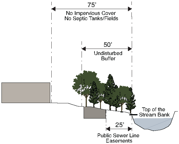
3.
No septic tanks or septic tank drain fields shall be permitted within the buffer or the setback.
B.
Variance Procedures
Variances from the above buffer and setback requirements may be granted in accordance with the following provisions:
1.
Where a parcel was platted prior to March 15, 2004, and its shape, topography or other existing physical condition prevents land development consistent with this Section, and the City Manager finds and determines that the requirements of this Section prohibit the otherwise lawful use of the property by the owner, the Zoning Board of Appeals may grant a variance from the buffer and setback requirements hereunder, provided such variance requires mitigation measures to offset the effects of any proposed land development on the parcel.
2.
Except as provided above, the Zoning Board of Appeals shall grant no variance from any provision of this Section without first conducting a public hearing on the application for variance and authorizing the granting of the variance by an affirmative vote of the Zoning Board of Appeals. The City shall give public notice of each such public hearing in accordance with the procedures for variances in Sec. 11.2.9. The City Manager shall be present at any such variance hearings and the Board shall consider the testimony of the City Manager when granting any variance or relief from the requirements of this Section.
3.
Variances will be considered only in the following cases:
a.
When a property's shape, topography or other physical conditions existing as of March 15, 2004 prevents land development unless a buffer variance is granted.
b.
Unusual circumstances when strict adherence to the minimal buffer requirements in the Section would create an extreme hardship.
4.
Variances will not be considered when, following adoption of this Section, actions of any property owner of a given property have created conditions of a hardship on that property.
5.
At a minimum, a variance request shall include the following information in addition to the requirements of Article 11.:
a.
A site map that includes locations of all streams, wetlands, floodplain boundaries and other natural features, as determined by field survey;
b.
A description of the shape, size, topography, slope, soils, vegetation and other physical characteristics of the property;
c.
A detailed site plan that shows the locations of all existing and proposed structures and other impervious cover, the limits of all existing and proposed land disturbance, both inside and outside the buffer and setback. The exact area of the buffer to be affected shall be accurately and clearly indicated;
d.
Documentation of unusual hardship should the buffer be maintained;
e.
At least one alternative plan, which does not include a buffer or setback intrusion, or an explanation of why such a site plan is not possible;
f.
A calculation of the total area and length of the proposed intrusion;
g.
A stormwater management site plan, if applicable; and
h.
Proposed mitigation, if any, for the intrusion. If no mitigation is proposed, the request must include an explanation of why none is being proposed.
6.
In addition to the variance criteria for approval in Article 11., the following factors will be considered in determining whether to issue a variance:
a.
The shape, size, topography, slope, soils, vegetation and other physical characteristics of the property;
b.
The locations of all streams on the property, including along property boundaries;
c.
The location and extent of the proposed buffer or setback intrusion;
d.
Whether alternative designs are possible which require less intrusion or no intrusion;
e.
The long-term and construction water-quality impacts of the proposed variance; and
f.
Whether issuance of the variance is at least as protective of natural resources and the environment.
9.2.6. - Other Buffer Regulations and Requirements
This Section is not intended to interfere with, abrogate or annul any other ordinance, rule or regulation, statute or other provision of law. The requirements of this Section should be considered minimum requirements, and where any provision of this Section imposes restrictions different from those imposed by any other ordinance, rule, regulation or other provision of law, whichever provisions are more restrictive or impose higher protective standards for human health or the environment shall be considered to take precedence.
9.2.7. - Development on Buffer Zone Properties
A.
Any permit applications for property requiring buffers and setbacks hereunder must include the following:
1.
A site plan showing:
a.
The location of all streams on the property;
b.
Limits of required stream buffers and setbacks on the property;
c.
Buffer zone topography with contour lines at no greater than two-foot contour intervals;
d.
Delineation of forested and open areas in the buffer zone; and
e.
Detailed plans of all proposed land development in the buffer and of all proposed impervious cover within the setback.
2.
A description of all proposed land disturbance or land development within the buffer and setback;
3.
When a mitigation or restoration plan is required by the City Manager, such restoration plans shall be prepared by a registered professional engineer or other qualified professional familiar with stream bank restoration or bioengineering, as appropriate, and shall include a certification from such professional engineer or other qualified professional that the plan is in accordance with current recommended practices for the protection of riparian or aquatic environments; and
4.
Any other documentation that the City Manager may reasonably deem necessary for review of the application and to ensure that this Section is addressed in the approval process.
B.
All buffer and setback areas must be recorded on the final plat of the property following plan approval. In addition to the required paper copies, a digital file of the property survey, final plat or site plan depicting the affected stream buffer areas shall be provided to the City Manager in an acceptable format. The survey information shall be georeferenced to the State Plane Coordinate System (Georgia West).
9.2.8. - Responsibility
Neither the issuance of a development permit nor compliance with the conditions thereof, nor with the provisions of this Section shall relieve any person from any responsibility otherwise imposed by law for damage to persons or property; nor shall the issuance of any permit hereunder serve to impose any liability upon City, its officers or employees, for injury or damage to persons or property.
9.2.9. - Inspection
A.
The City Manager may cause inspections of the work in the buffer or setback to be made periodically during the course thereof and shall make a final inspection following completion of the work. The permittee shall assist the City Manager or the City Manager's designee in making such inspections. The City Manager shall have the authority to conduct such investigations as the City Manager may reasonably deem necessary to carry out the City Manager's duties as prescribed in this Section, and for this purpose to enter at reasonable times upon any property, public or private, for the purpose of investigating and inspecting the sites of any land development activities within the protection area.
B.
No person shall refuse entry or access to any authorized representative or agent of the City Manager who requests entry for purposes of inspection, and who presents appropriate credentials, nor shall any person obstruct, hamper or interfere with any such representative while in the process of carrying out the representative's official duties.
(Ord. No. O-22-11, § 3(Exh. B), 10-17-22)
9.2.10. - Violations, Enforcement and Penalties
Any action or inaction which violates the provisions of this article or the requirements of an approved site plan or permit may be subject to the enforcement actions outlined in this Section. Any such action or inaction which is continuous with respect to time is deemed to be a public nuisance and may be abated by injunctive or other equitable relief. The imposition of any of the penalties described below shall not prevent such equitable relief.
A.
Notice of Violation
If the City Manager determines that an applicant or other responsible person has failed to comply with the terms and conditions of a permit, an approved site plan or the provisions of this Section, the City Manager shall issue a written notice of violation to such applicant or other responsible person. Where a person is engaged in activity covered by this article without having first secured the appropriate permit therefor, the notice of violation shall be served on the owner or the responsible person in charge of the activity being conducted on the site. The notice of violation shall contain:
1.
The name and address of the owner or the applicant or the responsible person;
2.
The address or other description of the site upon which the violation is occurring;
3.
A statement specifying the nature of the violation;
4.
A description of the remedial measures necessary to bring the action or inaction into compliance with the permit, the approved site plan or this article and the date for the completion of such remedial action;
5.
A statement of the penalty or penalties that may be assessed against the person to whom the notice of violation is directed; and
6.
A statement that the determination of violation may be appealed to the Zoning Board of Appeals by filing a written notice of appeal within 10 calendar days after the notice of violation (except that in the event the violation constitutes an immediate danger to public health or public safety, 24 hours notice shall be sufficient).
B.
Penalties
In the event the remedial measures described in the notice of violation have not been completed by the date set forth for such completion in the notice of violation, any one or more of the following actions or penalties may be taken or assessed against the person to whom the notice of violation was directed. Before taking any of the following actions or imposing any of the following penalties, the City Manager shall first notify the applicant or other responsible person in writing of its intended action, and shall provide a reasonable opportunity, of not less than ten days (except that in the event the violation constitutes an immediate danger to public health or public safety, 24 hours notice shall be sufficient) to cure such violation. In the event the applicant or other responsible person fails to cure such violation after such notice and cure period, the City Manager may take any one or more of the following actions or impose any one or more of the following penalties.
1.
Stop Work Order
The City Manager may issue a stop work order which shall be served on the applicant or other responsible person. The stop work order shall remain in effect until the applicant or other responsible person has taken the remedial measures set forth in the notice of violation or has otherwise cured the violation or violations described therein, provided the stop work order may be withdrawn or modified to enable the applicant or other responsible person to take necessary remedial measures to cure such violation or violations.
2.
Withhold Certificate of Occupancy
The City Manager may refuse to authorize a certificate of occupancy for the building or other improvements constructed or being constructed on the site until the applicant or other responsible person has taken the remedial measures set forth in the notice of violation or has otherwise cured the violations described therein.
3.
Suspension, Revocation or Modification of Permit
The City Manager may suspend, revoke or modify the permit authorizing the land development project. A suspended, revoked or modified permit may be reinstated after the applicant or other responsible person has taken the remedial measures set forth in the notice of violation or has otherwise cured the violations described therein, provided such permit may be reinstated (upon such conditions as the City Manager may deem necessary) to enable the applicant or other responsible person to take the necessary remedial measures to cure such violations.
4.
Penalties
In the event the applicant or other responsible person fails to take the remedial measures set forth in the notice of violation or otherwise fails to cure the violations described therein within ten days (or such greater period as the City Manager shall deem appropriate) (except that in the event the violation constitutes an immediate danger to public health or public safety, 24 hours notice shall be sufficient) after the City Manager has taken one or more of the actions described above, the City Manager may issue a citation to the applicant or other responsible person, requiring such person to appear in municipal court to answer charges for such violation. Any violation of this article is punishable, upon conviction, according to the provisions of Section 1-12 of the Code of Ordinances. Each day any violation of this Section shall continue shall constitute a separate defense.
C.
Appeals
Any person aggrieved by a decision or order of the City Manager may file an appeal to the Board of Zoning Appeals pursuant to the provisions of Sec. 11.2.10.
(Ord. No. O-15-01, § 2, 1-20-15; Ord. No. O-22-11, § 3(Exh. B), 10-17-22)
9.3.1. - Description
This Section addresses post-development stormwater management requirements for new development and redevelopment in the City. The Section defines requirements for a post-development stormwater management plan, which is required in order to undertake land development activities. The plan shall contain the details of how the development will address post-development stormwater runoff quality and quantity impacts resulting from the permanent alteration of the character and hydrology of the land surface as well as the nonpoint source pollution from land use activities. The Section also outlines the water quantity and quality performance design criteria for managing this runoff and specifies local requirements for the use of structural stormwater controls and nonstructural practices, in order to protect public health and safety; for the protection of public and private property and infrastructure, and for the protection of the environment. Ongoing long-term inspection and maintenance provisions are also required by this Section. The majority of technical criteria and standards required by this Section are adopted by reference through the use of the Georgia Stormwater Management Design Manual, as may be amended by local requirements contained in the City's stormwater management policy guidelines.
9.3.2. - Introduction
It is hereby determined that:
A.
Land development projects and other land use conversions, and their associated changes to land cover, permanently alter the hydrologic response of local watersheds and increase stormwater runoff rates and volumes, which in turn increase flooding, stream channel erosion, and sediment transport and deposition;
B.
Land development projects and other land use conversions also contribute to increased nonpoint source pollution and degradation of receiving waters;
C.
The impacts of post-development stormwater runoff quantity and quality can affect public safety, public and private property, drinking water supplies, recreation, fish and other aquatic life, property values and other uses of lands and waters; These adverse impacts can be controlled and minimized through the regulation of stormwater runoff quantity and quality from new development and redevelopment, by the use of both structural facilities as well as nonstructural measures, such as the conservation of open space and greenspace areas. The preservation and protection of natural area and greenspace for stormwater management benefits is encouraged through the use of incentives or "credits." The Georgia Greenspace Program provides a mechanism for the preservation and coordination of those greenspace areas which provide stormwater management quality and quantity benefits;
D.
Localities in the State of Georgia are required to comply with a number of both state and federal laws, regulations and permits which require a locality to address the impacts of post-development stormwater runoff quality and nonpoint source pollution;
E.
Therefore, the City has established this set of stormwater management policies to provide reasonable guidance for the regulation of post-development stormwater runoff for the purpose of protecting local water resources from degradation. It has determined that it is in the public interest to regulate post-development stormwater runoff discharges in order to control and minimize increases in stormwater runoff rates and volumes, post-construction soil erosion and sedimentation, stream channel erosion, and nonpoint source pollution associated with post-development stormwater runoff.
9.3.3. - General Provisions
A.
Purpose and Intent
The purpose of this Section is to protect, maintain and enhance the public health, safety, environment and general welfare by establishing minimum requirements and procedures to control the adverse effects of increased post-development stormwater runoff and nonpoint source pollution associated with new development and redevelopment. It has been determined that proper management of post-development stormwater runoff will minimize damage to public and private property and infrastructure, safeguard the public health, safety, environment and general welfare of the public, and protect water and aquatic resources. Additionally, the City of Decatur is required to comply with several State and Federal laws, regulations and permits and the requirements of the Metropolitan North Georgia Water Planning District's regional water plan related to managing the water quantity, velocity, and quality of post-construction stormwater runoff. This Section seeks to meet that purpose through the following objectives:
1.
Establish decision-making processes surrounding land development activities that protect the integrity of the watershed and preserve the health of water resources;
2.
Require that new development and redevelopment maintain the pre-development hydrologic response in their post-development state as nearly as practicable in order to reduce flooding, streambank erosion, nonpoint source pollution and increases in stream temperature, and maintain the integrity of stream channels and aquatic habitats;
3.
Establish minimum post-development stormwater management standards and design criteria for the regulation and control of stormwater runoff quantity and quality;
4.
Establish design and application criteria for the construction and use of structural stormwater control facilities that can be used to meet the minimum post-development stormwater management standards;
5.
Encourage the use of nonstructural stormwater management and stormwater better site design practices, such as the preservation of greenspace and other conservation areas, to the maximum extent practicable. Coordinate site design plans, which include greenspace, with the County's greenspace protection plan;
6.
Encourage preservation of existing tree canopy by reducing the applicable post-development stormwater management performance criteria, as specified in Section 9.3.5.
7.
Encourage the use of green infrastructure and low impact development practices as defined in the Georgia Stormwater Management Manual by reducing the applicable post-development stormwater management performance criteria, as specified in Section 9.3.5.
8.
Require new developments and redeveloped properties that generate concentrated stormwater flows to connect to nearby storm sewer systems via underground conveyance;
9.
Require new developments and redeveloped properties that generate concentrated stormwater flows to discharge above-ground flows into a stabilized, engineered channel from the point of release to the point of connection to the public stormwater system if connection to such storm sewer system via underground conveyance is not feasible;
10.
Manage runoff impacts to adjacent properties by requiring post development runoff to be directed away from existing adjacent structures and released in a manner similar to the existing condition and by maintaining a drainage path for any existing off-site runoff that drains through the site;
11.
Establish provisions for the long-term responsibility for maintenance of structural stormwater control facilities, and nonstructural stormwater management practices, green infrastructure practices, low impact development practices, and maintaining existing trees/canopies to be preserved to ensure that they continue to function as designed, are maintained, and pose no threat to public health and safety; and
12.
Establish administrative procedures for the submission, review, approval and disapproval of stormwater management plans, and for the inspection of approved active projects, and long-term follow up.
B.
Additional Requirements
The list above is a general set of objectives to reduce the impacts of post-development stormwater runoff quantity and quality from land development activities. The City may establish additional requirements in the stormwater management policy guidelines, which set more specific objectives based upon a watershed management plan, a National Pollutant Discharge Elimination System (NPDES) permit requirement, impervious surface targets, the findings of a watershed assessment or study, or in order to address a local flooding or water quality problem or to assist in compliance with a pollutant total maximum daily load (TMDL) goal or restriction.
C.
Applicability
This Section shall be applicable to all land development, including, but not limited to, site plan applications, subdivision applications, land disturbance applications, and grading applications. The following applicability table lists categories of sites and developments and defines applicable stormwater management criteria based upon defined parameters of improvements or land disturbing activities associated with the project. The standards of this Section (including, but not limited to, the performance criteria of Section 9.3.5.) apply to all new development or redevelopment unless otherwise indicated in the following table.
Applicability Table
Applicability Table Notes:
1.
When conducting stormwater management performance criteria calculations, the pre-developed condition of an existing impervious area that is removed shall revert to the coefficient/curve number for such area in its natural undeveloped state. (Refer to Pre-development definition within Article 12. and the City's Stormwater Management Policy Guidelines.)
2.
When performing the overbank and extreme flood protection stormwater management criteria, attenuate the stormwater runoff to a level of 90 percent of that which would be generated from the site in its natural undeveloped state for all storms from the two-year, five-year, ten-year, 25-year, 50-year, and 100-year storm. Refer to Section 9.3.5.F. and Section 9.3.5.G. for overbank and extreme flood protection performance criteria; Sec. 9.3.4.C.3.d. for redevelopment site limits; and the City's Stormwater Management Policy Guidelines.
3.
In subdivisions and/or similar phased development projects, multiple separate and distinct land development activities may take place at different schedules. In order to establish the applicable parameter that defines the development, the creation, addition, and/or replacement of impervious areas shall be totaled for all of the multiple separate land activities that will be associated with the site, regardless of ownership.
4.
A 0.55 cfs increase is equivalent to approximately 4,000 square feet of impervious surface.
5.
If the site does not have an existing stormwater detention facility, the required attenuation of the post-development stormwater runoff to meet the stream channel protection, overbank flood protection and extreme flood protection criteria may be deferred no more than once in a five-year period. Any such deferral expires at the time of any subsequent development or redevelopment of the property.
6.
Linear transportation projects being constructed by the City of Decatur to the extent the administrator determines that the stormwater management standards may be infeasible to apply, all or in part, for any portion of the linear transportation project. For this exemption to apply, an infeasibility report that is compliant with the City's linear feasibility program shall first be submitted to the administrator that contains adequate documentation to support the evaluation for the applicable portion(s) and any resulting infeasibility determination by the administrator.
D.
Designation of Administrator
The UDO Administrator is designated to administer this Section 9.3. Unless stated explicitly otherwise, whenever reference is made in this Section 9.3 to the "City Manager" or the "administrator," such reference is to the UDO Administrator.
E.
Compatibility with Other Regulations
This Section is not intended to modify or repeal any other ordinance, rule, regulation or other provision of law, including, but not limited to, any applicable stream buffers under state and local laws, and the Georgia Safe Dams Act and Rules for Dam Safety. In the event of any conflict or inconsistency between any provision in the City of Decatur's MS4 permit and this Section, the provision from the MS4 permit shall control. In the event of any conflict or inconsistency between any provision of this Section and the Georgia Stormwater Management Manual, the provision from this Section shall control. In the event of any other conflict or inconsistency between any provision of this Section and any other ordinance, rule, regulation or other provision of law, the provision that is more restrictive or imposes higher protective standards for human health or the environment shall control.
If any provision of this Section is invalidated by a court of competent jurisdiction, such judgment shall not affect or invalidate the remainder of this Section.
F.
Stormwater Design Manual
The City Manager will utilize the policy, criteria and information including technical specifications and standards in the latest edition of the Georgia Stormwater Management Manual (GSMM) and any relevant local addenda as may be established in the City's stormwater management policy guidelines, for the proper implementation of the requirements of this article. In implementing this Section, the City shall use and require compliance with all design standards, calculations, formulas, methods, and other guidance from the GSMM as well as all related appendices. The GSMM and the City's stormwater management policy guidelines may be updated and expanded periodically, based on improvements in science, engineering, monitoring and local maintenance experience. All references to the GSMM shall mean the latest edition.
9.3.4. - Permit Procedures and Requirements
A.
Permit Application Requirements
1.
No owner or developer shall perform any land development activities without first meeting the requirements of this Section and obtaining a stormwater management permit prior to commencing the proposed activity.
2.
Unless specifically exempted by this Section, any owner or developer proposing a land development activity shall submit to the City Manager a permit application on a form provided by the City Manager for that purpose.
3.
Unless otherwise exempted by this Section, a permit application shall be accompanied by the following items in order to be considered:
a.
Stormwater concept plan and consultation meeting certification in accordance with Section 9.3.4.B.;
b.
Stormwater management plan in accordance with Section 9.3.4.C.;
c.
Inspection and maintenance agreement in accordance with Section 9.3.4.D., if applicable;
d.
Performance bond in accordance with Section 9.3.4.E., if applicable; and
e.
Permit application and plan review fees in accordance with Section 9.3.4.F.
B.
Stormwater Concept Plan Meeting
Before any stormwater management permit application is submitted, it is recommended that the land owner or developer meet with the City Manager for a consultation meeting on a concept plan for the post-development stormwater management system to be utilized in the proposed land development project. This consultation meeting should take place at the time of the preliminary plan of subdivision or other early step in the development process, and before formal application is made to the Planning Commission for subdivision or site plan approval. The purpose of this meeting is to discuss the post-development stormwater management measures necessary for the proposed project, as well as to discuss and assess constraints, opportunities and potential ideas for stormwater management designs before the formal site design engineering is commenced. Applicants must request a pre-submittal meeting with the City Manager when applying for a Determination of Infeasibility through the Practicability Policy. The stormwater concept plan shall be prepared using the minimum following steps: (1) Develop the site layout using better site design techniques, as applicable (GSMM Section 2.3). (2) Calculate preliminary estimates of the unified stormwater sizing criteria requirements for stormwater runoff quality/reduction, channel protection, overbank flooding protection and extreme flood protection (GSMM Section 2.2). (3) Perform screening and preliminary selection of appropriate best management practices and identification of potential siting locations (GSMM Section 4.1).
The following information should be included in the concept plan which should be submitted in advance of the meeting:
1.
Common Address and Legal Description of the Site
The description shall include a metes and bounds description of the site, parcel tax ID, and total site acreage.
2.
Vicinity Map
The vicinity map shall be at a scale no larger than one inch equals 1,000 feet and shall show the boundaries of the site relative to the surrounding area.
3.
Existing Conditions/Proposed Site Plans
Existing conditions and proposed site layout sketch plans, which illustrate at a minimum: existing and proposed topography; perennial and intermittent streams; mapping of predominant soils from soil surveys; boundaries of existing predominant vegetation and proposed limits of clearing and grading; location of existing and proposed roads, buildings, walkways, parking areas and other impervious surfaces; and location of existing and proposed utilities (e.g. water, sewer, gas, and electric). Plans shall be at a minimum scale of one inch equals 20 feet and shall contain elevation contours at a minimum two-foot intervals, or as otherwise stipulated in the stormwater management policy guidelines.
4.
Natural Resources Inventory
A written or graphic inventory of the natural resources at the site and surrounding area as it exists prior to the commencement of the project. This description should include a discussion of soil conditions, tree inventory with size and health, topography, wetlands, and other native vegetative areas on the site, as well as the location and boundaries of other natural feature protection and conservation areas such as wetlands, lakes, ponds, floodplains, stream buffers and other setbacks (e.g., drinking water well setbacks, septic set-backs, etc.). Particular attention should be paid to environmentally sensitive features that provide particular opportunities or constraints for development.
5.
Stormwater Management System Concept Plan
A written or graphic concept plan of the proposed post-development stormwater management system including: preliminary estimate of unified stormwater sizing criteria requirements, preliminary selection and location of proposed structural stormwater controls; location of existing and proposed conveyance systems such as grass channels, swales, and storm drains; flow paths; location of floodplain and floodway limits; relationship of site to upstream and downstream properties and drainages; and preliminary location of proposed stream channel modifications, such as bridge or culvert crossings, where applicable. Local watershed plans, the City's greenspace protection plan (if applicable), and any relevant resource protection plans will be consulted in the discussion of the concept plan.
C.
Stormwater Management Plan Requirements
1.
The stormwater management plan shall detail how post-development stormwater runoff will be controlled or managed and how the proposed project will meet the requirements of this Section, including the performance criteria set forth in Section 9.3.5. below. This plan shall be in accordance with the criteria established in this Section and be prepared under the direct supervisory control of either a registered professional engineer or a registered land-scape architect licensed in the State of Georgia. The requirements of Section 9.3.4.C.3.c., Existing Conditions Hydrologic Analysis, Section 9.3.4.C.3.d., Post-Development Hydrologic Analysis, Section 9.3.4.C.3.e., Stormwater Management System and Section 9.3.4.C.3.f., Post-Development Downstream Analysis shall be prepared under the direct supervisory control of a registered professional engineer, who shall seal and sign the work. The overall site plan must be stamped by a design professional licensed in the State of Georgia for such purpose.
2.
The stormwater management plan must ensure that the requirements and criteria in this Section are being complied with and that opportunities are being taken to minimize adverse post-development stormwater runoff impacts from the development. In addition to the requirements stipulated in the stormwater management policy guidelines, the stormwater management plan shall comply with the following requirements:
a.
Concentrated Stormwater Runoff
All new development and redeveloped properties that generate a concentrated stormwater flow are required to:
i.
Connect to nearby storm sewer systems via underground conveyances.
ii.
Discharge such concentrated flows into a stabilized, engineered channel, from the point of release to the point of connection to the public stormwater system in cases where the City Manager determines that connection to existing storm sewer systems via underground conveyances is not feasible.
iii.
Prevent concentrated surface stormwater discharge across streets, sidewalks, or other public improvements. Such concentrated surface stormwater discharge is not permitted.
b.
Manage Runoff Impacts
Manage runoff impacts to adjacent properties by requiring post-development runoff to be directed away from existing adjacent structures and released in a manner similar to the existing condition, and by maintaining a drainage path for any existing off-site runoff that drains through the site. The predevelopment runoff patterns/paths shall be maintained.
c.
Detention or Retention
In order to minimize the risk of pollution or adverse environmental impact, stormwater detention or retention ponds shall be set back from property boundaries and other objects and areas a minimum distance, as follows:
i.
Ten feet from a building foundation;
ii.
Ten feet from a property line;
iii.
100 feet from a private well;
iv.
250 feet from a known contaminate source;
v.
50 feet from a septic system tank or leach field.
d.
Green Infrastructure
In order to minimize the risk of pollution and/or adverse environmental impact, all green infrastructure, runoff reduction, and/or infiltration practices shall be set back from property boundaries and other objects and areas a minimum distance, as follows:
i.
Ten feet from a building foundation;
ii.
Ten feet from a property line;
iii.
100 feet from a private well;
iv.
250 feet from a known contaminate source;
v.
50 feet from a septic system tank or leach field;
vi.
Within the critical root zone of existing or proposed trees.
e.
Digital File
In addition to the required paper copies, a digital file of the property survey, final plat or site plan depicting the affected land disturbance and stormwater system areas shall be provided to the City Manager in an acceptable format. The survey information shall be geo-referenced to the State Plane Coordinate System (Georgia West) and the Mean Sea Level Datum.
f.
Fencing
Permanent fencing at least six feet in height shall be required around all detention or retention facilities having a maximum water depth of more than 3.5 feet or a bank with slope ratio greater than 1.5 horizontal to 1.0 vertical. Fencing shall be installed and maintained to allow the free flow of runoff into the detention or retention facility.
Fencing shall include a gate of sufficient size to permit entrance of equipment necessary to allow periodic maintenance. Fencing may be waived by the City Manager in nonresidential developments where the detention facility is 500 feet of more from a residence and in residential developments where detention is provided in natural areas such as stream channels, if permitted, and where fencing would affect stream flow or cause other environmental damage.
g.
Location of Detention Facilities
When an aboveground detention or retention facility is to be used on a site to be developed with single-family, two-family or townhouse dwellings, such a facility shall not be located in front of the front building line. This requirement may be waived by the City Commission when it is not feasible to achieve the required detention or retention in any other manner.
3.
The plan shall consist of maps, narrative, and supporting design calculations (hydrologic and hydraulic) for the proposed stormwater management system. The plan shall include all of the information required in the stormwater management site plan checklist found in the stormwater design manual. This includes:
a.
Natural Resources Inventory
See Section 9.3.4.B.4
b.
Stormwater Concept Plan
See Section 9.3.4.B.5
c.
Existing Conditions Hydrologic Analysis
The existing condition hydrologic analysis for stormwater runoff rates, volumes, and velocities, which shall include: a topographic map of existing site conditions with the drainage basin boundaries indicated; acreage, soil types and land cover of areas for each subbasin affected by the project; all perennial and intermittent streams and other surface water features; all existing stormwater conveyances and structural control facilities; direction of flow and exits from the site; analysis of runoff provided by off-site areas upstream of the project site; and methodologies, assumptions, site parameters and supporting design calculations used in analyzing the existing conditions site hydrology. For redevelopment sites, predevelopment conditions shall be modeled using the established guidelines for the portion of the site undergoing land development activities. The predevelopment conditions for redevelopment sites shall be modeled in accordance with the City's stormwater management policy guidelines.
d.
Post-Development Hydrologic Analysis
The post-development hydrologic analysis for stormwater runoff rates, volumes, and velocities, which shall include: a topographic map of developed site conditions with the post-development drainage basin boundaries indicated; total area of post-development impervious surfaces and other land cover areas for each subbasin affected by the project; calculations for determining the runoff volumes that need to be addressed for each subbasin for the development project to meet the post-development stormwater management performance criteria in Section 9.3.5.; location and boundaries of proposed natural feature protection and conservation areas; documentation and calculations for any applicable site design credits that are being utilized; methodologies, assumptions, site parameters and supporting design calculations used in analyzing the existing conditions site hydrology. If the land development activity on a redevelopment site constitutes more than 50 percent of the site area for the entire site, then the performance criteria in Section 9.3.5. must be met for the stormwater runoff from the entire site. The spread sheet-based computer modeling tool developed by the Metropolitan North Georgia Water Planning District, when available, may be utilized to perform the post-development hydrologic water quality analysis.
e.
Stormwater Management System
The description, scaled drawings and design calculations for the proposed post-development stormwater management system, which shall include: A map and/or drawing or sketch of the stormwater management facilities, including the location of nonstructural site design features and the placement of existing and proposed structural stormwater controls, including design water surface elevations, storage volumes available from zero to maximum hydraulic head, location of inlet and outlets, location of bypass and discharge systems, and all orifice/restrictor sizes for all outlet control structures or devices; a narrative describing how the selected structural stormwater controls will be appropriate and effective; cross-section and profile drawings and design details for each of the structural stormwater controls in the system, including supporting calculations to show that the facility is designed according to the applicable design criteria; a hydrologic and hydraulic analysis of the stormwater management system for all applicable design storms (including stage-storage or outlet rating curves, and inflow and outflow hydrographs); documentation and supporting calculations to show that the stormwater management system adequately meets the post-development stormwater management performance criteria in Section 9.3.5., drawings, design calculations, elevations and hydraulic grade lines for all existing and proposed stormwater conveyance elements including stormwater drains, pipes, culverts, catch basins, channels, swales and areas of overland flow; and where applicable, a narrative describing how the stormwater management system corresponds with any watershed protection plans and/or local greenspace protection plan for redevelopment and to the extent existing stormwater management structures are being used to meet stormwater management standards the following must also be included in the stormwater management plan for existing stormwater management structures: as-built drawings, hydrology reports, currently inspections of existing stormwater management structures with deficiencies notes, and BMP landscaping plans.
f.
Post-Development Downstream Analysis
A downstream peak flow analysis which includes the assumptions, results and supporting calculations to show safe passage of post-development design flows downstream. The analysis of downstream conditions in the report shall address each and every point or area along the project site's boundaries at which runoff will exit the property. The analysis shall focus on the portion of the drainage channel or watercourse immediately downstream from the project. This area shall extend downstream from the project to a point in the drainage basin where the project area is ten percent of the total basin area in accordance with Section 3.1.9 of the GSMM. This is to help ensure that there are minimal downstream impacts from development on the site. The downstream analysis may result in the need to resize structural components of the stormwater management system. In calculating runoff volumes and discharge rates, consideration may need to be given to any planned future upstream land use changes. The analysis shall be in accordance with the stormwater design manual, and any other requirements stipulated in the City's stormwater management policy guidelines.
g.
Construction-Phase Soil Erosion and Sedimentation Control Plan
An erosion and sedimentation control plan in accordance with Section 9.4. Soil Erosion and Sedimentation Control, and/or NPDES permit when required for construction activities. The plan shall also include information on the sequence/phasing of construction and temporary stabilization measures and temporary structures that will be converted into permanent stormwater controls.
h.
Landscaping and Open Space Plan
A detailed landscaping and vegetation plan describing the woody and herbaceous vegetation that will be used within and adjacent to stormwater management facilities and practices. The landscaping plan must also include: the arrangement of planted areas, natural and greenspace areas and other landscaped features on the site plan; information necessary to construct the landscaping elements shown on the plan drawings; descriptions and standards for the methods, materials and vegetation that are to be used in the construction; density of plantings; descriptions of the stabilization and management techniques used to establish vegetation; and a description of who will be responsible for ongoing maintenance of vegetation for the stormwater management facility and what practices will be employed to ensure that adequate vegetative cover is preserved.
i.
Operations and Maintenance Plan
Detailed description of ongoing operations and maintenance procedures for stormwater management facilities and practices to ensure their continued function as designed and constructed or preserved. These plans will identify the parts or components of a stormwater management facility or practice that need to be regularly or periodically inspected and maintained, and the equipment and skills or training necessary. The plan shall include an inspection and maintenance schedule, maintenance tasks, responsible parties for maintenance, funding, access and safety issues. Provisions for the periodic review and evaluation of the effectiveness of the maintenance program and the need for revisions or additional maintenance procedures shall be included in the plan.
j.
Maintenance Access Easements
The applicant must ensure access from public right-of-way to stormwater management facilities and practices requiring regular maintenance at the site for the purpose of inspection and repair by securing all the maintenance access easements needed on a permanent basis. Such access shall be sufficient for all necessary equipment for maintenance activities. Easements shall be centered on the pipe and provide a width equal to two times the sum of the pipe diameter plus depth. (e.g., a 36-inch pipe, 8 feet deep would need a 22 feet easement width.) Upon final inspection and approval, a plat or document indicating that such easements exist shall be recorded and shall remain in effect even with the transfer of title of the property. The local government will establish which stormwater facilities and practices will require regular maintenance.
k.
Inspection and Maintenance Agreements
Unless an on-site stormwater management facility or practice is acceptable to the City Manager and is dedicated to and accepted by the City, including all drainage facilities, best management practices, credited conservation spaces, and conveyance systems, as provided in Section 9.3.4.D. below, the applicant must execute an easement and an inspection and maintenance agreement binding on all subsequent owners of land served by an onsite stormwater management facility or practice in accordance with Section 9.3.4.D. All new development and redevelopment sites are to prepare a comprehensive inspection and maintenance agreement for the on-site stormwater management system
i.
Local and Non-Local Permits
The applicant shall certify and provide documentation to the City Manager that all other applicable environmental permits have been acquired for the site prior to approval of the stormwater management plan.
ii.
Determination of Infeasibility
In some instances, installation of runoff reduction practices may be determined infeasible through engineering analysis. Applicants should reference the most recent Practicability Policy for examples of situations that may warrant Infeasibility.
Applicants must develop a written report documenting the practicability issues with the site and must request a pre-submittal meeting with the City Manager when applying for a Determination of Infeasibility through the Practicability Policy.
D.
Stormwater Management Inspection and Maintenance Agreements
Prior to the issuance of any permit for a land development activity requiring a stormwater management facility or practice hereunder and for which the City Manager requires ongoing maintenance, the applicant or owner of the site must, unless an on-site stormwater management facility or practice is dedicated to and accepted by the City, execute an inspection and maintenance agreement, and/or a conservation easement, if applicable, that shall be binding on all subsequent owners of the site.
The executed stormwater management inspection and maintenance agreement shall include, but is not limited to, structural stormwater control facilities, nonstructural stormwater management practices, green infrastructure practices, low impact development practices, runoff reduction, and maintaining existing trees/canopies to be preserved.
1.
All private stormwater facilities and practices will require formal inspection and maintenance agreements.
2.
The inspection and maintenance agreement, if applicable, must be approved by the City Manager prior to plan approval, and recorded in the County deed records upon final plat or site plan approval.
3.
The inspection and maintenance agreement shall identify by name or official title the person(s) responsible for carrying out the inspection and maintenance. Responsibility for the operation and maintenance of the stormwater management facility or practice, unless the facility is dedicated to, and officially accepted by a governmental agency, shall remain with the property owner and shall pass to any successor owner. The inspection and maintenance agreement shall run with the land and bind all future successors-in-title of the site. If portions of the site are sold or otherwise transferred, legally binding arrangements shall be made to assign the inspection and maintenance responsibility to the appropriate successors in title. These arrangements shall designate for each portion of the site, the person to be permanently responsible for its inspection and maintenance. In the absence of a recorded assignment agreement, all owners of the site shall be jointly and severally liable for all obligations under the inspection and maintenance agreement regardless of what portion of the site they own.
4.
As part of the inspection and maintenance agreement, a schedule shall be developed for when and how often routine inspection and maintenance will occur to ensure proper function of the stormwater management facility or practice. The agreement shall also include plans for annual inspections to ensure proper performance of the facility between scheduled maintenance and shall also include remedies for the default thereof.
5.
In addition to enforcing the terms of the inspection and maintenance agreement, the City Manager may also enforce all of the provisions for ongoing inspection and maintenance in Section 9.3.5.
6.
The City, in lieu of an inspection and maintenance agreement, may accept dedication of any existing or future stormwater management facility for maintenance, provided such facility meets all the requirements of this Section and includes adequate and perpetual access and sufficient area, by fee simple title, for inspection and regular maintenance.
7.
The City Manager or the City Manager is authorized to execute such maintenance agreements on behalf of the City, including any such maintenance agreements entered into prior to the enactment of this Section.
E.
Performance and Maintenance Bonds
Maintenance of private facilities shall be performed in accordance with and at the frequency stipulated by the maintenance agreement. If upon an inspection by the City Manager, it is found that the facility is not being maintained in accordance with maintenance agreement, the City Manager may require that, in addition to the owner providing the required maintenance to bring the facility into compliance with the applicable regulations, the owner shall post a performance bond with the City, in an amount stipulated by the City Manager, to ensure the future maintenance obligations are met.
F.
Application Procedure
1.
Applications for land development permits shall be filed with the City Manager.
2.
Permit applications shall include the items set forth in Section 9.3.4.A. above (two copies of the stormwater management plan and the inspection maintenance agreement, if applicable, shall be included).
3.
The City Manager shall inform the applicant whether the application, stormwater management plan and inspection and maintenance agreement are approved or disapproved.
4.
If either the permit application, stormwater management plan or inspection and maintenance agreement are disapproved, the City Manager shall notify the applicant of such fact in writing. The applicant may then revise any item not meeting the requirements hereof and resubmit the same, in which event Section 9.3.4.F.3. above and this paragraph shall apply to such resubmittal.
5.
Upon a finding by the City Manager that the permit application, stormwater management plan and inspection and maintenance agreement, if applicable, meet the requirements of this Section, the City Engineer may issue a permit for the land development project, provided all other legal requirements for the issuance of such permit have been met.
6.
Notwithstanding the issuance of the permit, in conducting the land development project, the applicant or other responsible person shall be subject to the following requirements:
a.
The applicant shall comply with all applicable requirements of the approved plan and this Section and shall certify that all land clearing, construction, land development and drainage will be done according to the approved plan;
b.
The land development project shall be conducted only within the area specified in the approved plan;
c.
The City Manager shall be allowed to conduct periodic inspections of the project;
d.
No changes may be made to an approved plan without review and written approval by the City Manager; and
e.
Upon completion of the project, the applicant or other responsible person shall submit the engineer's report and certificate and as-built plans required by Section 9.3.6.B.
G.
Application Review Fees
The fee for review of any stormwater management application shall be based on the fee structure established by the City and shall be made at the time of application, and prior to the review of the application. No building permit for the development shall be issued until all required stormwater and soil erosion and sediment control permits and review fees have been paid.
H.
Modifications for Off-Site Facilities
1.
The stormwater management plan for each land development project shall provide for stormwater management measures located on the site of the project, unless provisions are made to manage stormwater by an off-site or regional facility. The off-site or regional facility must be located on property legally dedicated for the purpose, must be located on a fee simple lot with adequate access if it is to be dedicated to the City, must be designed and adequately sized to provide a level of stormwater quantity and quality control that is equal to or greater than that which would be afforded by on-site practices and there must be a legally-obligated entity responsible for long-term operation and maintenance of the off-site or regional stormwater facility. In addition, on-site measures shall be implemented, where necessary, to protect upstream and downstream properties and drainage channels from the site to the off-site facility. A stormwater management plan must be submitted to the City Manager which shows the adequacy of the off-site or regional facility.
2.
To be eligible for a modification, the applicant must demonstrate to the satisfaction of the City Manager that the use of an off-site or regional facility will not result in the following impacts to upstream or downstream areas:
a.
Increased threat of flood damage to public health, life, and property;
b.
Deterioration of existing culverts, bridges, dams, and other structures;
c.
Accelerated streambank or streambed erosion or siltation;
d.
Degradation of in-stream biological functions or habitat;
e.
Water quality impairment in violation of state water quality standards, and/or violation of any known state or federal regulations; or
f.
Adverse impact to the Municipal Separate Storm Sewer System's National Pollutant Discharge Elimination System (NPDES) permit.
9.3.5. - Post-Development Stormwater Management Performance Criteria
The following performance criteria shall be applicable to all stormwater management plans, unless otherwise provided for in this Section:
A.
Design of Stormwater Management System
The design of the stormwater management system shall be in accordance with the applicable sections of the GSMM as directed by the administrator. Any design which proposes a dam shall comply with the Georgia Safe Dams Act and Rules for Dam Safety as applicable.
All stormwater runoff generated from a site shall be adequately treated before discharge. It will be presumed that a stormwater management system complies with this requirement if:
1.
It is sized to treat the prescribed runoff reduction and/or water quality treatment volume from the site, as defined in the GSMM;
2.
Appropriate structural stormwater controls or nonstructural practices are selected, designed, constructed or preserved, and maintained according to the specific criteria in the GSMM;
3.
Appropriate green infrastructure practices and low impact development practices are selected, designed, constructed or preserved, and maintained according to the specific criteria in the GSMM;
4.
Preservation of existing tree canopies as defined in the City's Stormwater Management Policy Guidelines; and
5.
Runoff from hotspot land uses and activities identified by the City Manager are adequately treated and addressed through the use of appropriate structural stormwater controls, nonstructural practices and pollution prevention practices.
B.
Natural Resources Inventory
Site reconnaissance and surveying techniques shall be used to complete a thorough assessment of existing natural resources, both terrestrial and aquatic, found on the site. Resources to be identified, mapped, and shown on the Stormwater Management Plan, shall include, at a minimum (as applicable):
1.
Topography (minimum of two-foot contours) and Steep Slopes (i.e., areas with slopes greater than 15 percent),
2.
Natural Drainage Divides and Patterns,
3.
Natural Drainage Features (e.g., swales, basins, depressional areas),
4.
Natural feature protection and conservation areas such as wetlands, lakes, ponds, floodplains, stream buffers, drinking water wellhead protection areas and river corridors,
5.
Predominant soils (including erodible soils and karst areas), and
6.
Existing predominant vegetation including size and health of trees, high quality habitat and other existing vegetation.
C.
Better Site Design Practices for Stormwater Management
Stormwater management plans shall preserve the natural drainage and natural treatment systems and reduce the generation of additional stormwater runoff and pollutants to the maximum extent practicable. Additional details can be found in the GSMM Section 2.3.
D.
Stormwater Runoff Quality/Reduction
Stormwater Runoff Quality/Reduction shall be provided by using the following:
1.
For development with a stormwater management plan submitted before January 1, 2019 the applicant may choose either (A) Runoff Reduction or (B) Water Quality.
2.
For development with a stormwater management plan submitted on or after January 1, 2019, the applicant shall choose (A) Runoff Reduction and additional water quality shall not be required, if Runoff Reduction is provided in a serviceable pretreatment method. To the extent (A) Runoff Reduction has been determined to be infeasible for all or a portion of the site using the Practicability Policy, then (B) Water Quality shall apply for the remaining runoff from a 1.2 inch rainfall event and must be treated to remove at least 80 percent of the calculated average annual post-development total suspended solids (TSS) load or equivalent as defined in the GSMM.
a.
Runoff Reduction—The stormwater management system shall be designed to retain and cause infiltration of the first 1.0 inch of rainfall from impervious surfaces plus additional compensation for tree removal on the site using runoff reduction methods, to the maximum extent practicable. Compensation for existing tree removal on site shall be made through the addition of one cubic foot of runoff reduction for each 500 square feet of existing tree canopy removed.
b.
Water Quality—The stormwater management system shall be designed to remove at least 80 percent of the calculated average annual post-development total suspended solids (TSS) load or equivalent as defined in the GSMM for runoff from 1.2 inch rainfall event plus additional compensation for tree removal. Compensation for existing tree removal on site shall be made through the addition of 1.2 cubic feet of water quality treatment for each 500 square feet of existing tree canopy removed.
3.
If a site determined to be a hotspot (as defined by City Manager), the City may require the use of specific or additional components for the stormwater management system to address pollutants of concern generated by that site.
E.
Stream Channel Protection
Protection of stream channels from bank and bed erosion and degradation shall be provided by using all of the following three approaches:
1.
Preservation, restoration and/or reforestation (with native vegetation) of the 75-foot stream buffer required by Section 9.2. Stream Buffer Protection.
2.
24-hour extended detention storage of the one-year, 24-hour return frequency storm event. This requirement may be adjusted or waived by the City Manager for sites that discharge directly into larger streams, rivers, wetlands, or lakes, or to a man-made channel or conveyance system where the reduction in these flows will not have an impact on upstream or downstream streambank or channel integrity, and provided that in any case where the requirements for stream channel protection are not met on site, the applicant shall pay into a stormwater mitigation bank established by the City the cost of providing the required level of stream channel protection, including easements and/or property acquisition costs and cost of design and construction of the appropriate treatment protection feature or features.
3.
Erosion prevention measures such as energy dissipation and velocity control.
F.
Overbank Flooding Protection
Downstream overbank flood and property protection shall be provided by controlling (attenuating) the post-development peak discharge rate to 90 percent of the pre-development rate for the two-year through 25-year, 24-hour return frequency storm event. This requirement may be adjusted or waived by the City Manager for sites where the post-development downstream analysis submitted by the applicant shows that uncontrolled post-development conditions will not increase downstream peak flows, or that meeting the requirement will cause greater peak flow downstream impacts than the uncontrolled post-development conditions, and provided that in any case where the requirements for overbank flood protection are not met on site, the applicant shall pay into a stormwater mitigation bank established by the City the cost of providing the required level of overbank flood protection, including easements and/or property acquisition costs and cost of design and construction of the appropriate treatment protection feature or features.
G.
Extreme Flooding Protection
Extreme flood and public safety protection shall be provided by controlling (attenuating) and safely conveying the post-development peak discharge rate to 90 percent of the pre-development rate for the 50-year and 100-year, 24-hour return frequency storm event such that flooding is not exacerbated. This requirement may be adjusted or waived by the City Manager for sites where the post-development downstream analysis submitted by the applicant shows that uncontrolled post-development conditions will not increase downstream peak flows, or that meeting the requirement will cause greater peak flow downstream impacts than the uncontrolled post-development conditions, and provided that in any case where the requirement for extreme flood protection are not met on site, the applicant shall pay into a stormwater mitigation bank established by the City the cost of providing the required level of extreme flood protection, including easements and/or property acquisition costs and cost of design and construction of the appropriate treatment protection feature or features.
H.
Structural Stormwater Controls
All structural stormwater management facilities shall be selected and designed using the appropriate criteria from the Georgia Stormwater Management Manual. All structural stormwater controls must be designed appropriately to meet their intended function. For other structural stormwater controls not included in the Georgia Stormwater Management Manual or the City's stormwater management policy guidelines, or for which pollutant removal rates have not been provided, the effectiveness and pollutant removal of the structural control must be documented through prior studies, literature reviews, or other means and receive approval from the City Manager before being included in the design of a stormwater management system. In addition, if hydrologic or topographic conditions, or land use activities warrant greater control than that provided by the minimum control requirements, the City Manager may impose additional requirements deemed necessary to protect upstream and downstream properties and aquatic resources from damage due to increased volume, frequency, and rate of stormwater runoff or increased nonpoint source pollution loads created on the site in question. Applicants shall consult the Georgia Stormwater Management Manual for guidance on the factors that determine site design feasibility when selecting and locating a structural stormwater control.
I.
Stormwater Credits for Nonstructural Measures
The use of one or more site design measures by the applicant may allow for a reduction in the water quality treatment volume required above. The applicant may, if approved by the City Manager, take credit for the use of stormwater better site design practices and reduce the water quality volume requirement. For each potential credit, there is a minimum set of criteria and requirements which identify the conditions or circumstances under which the credit may be applied. The site design practices that qualify for this credit and the criteria and procedures for applying and calculating the credits are included in the Georgia Stormwater Management Manual.
J.
Green Infrastructure and Low Impact Development Practices
The use of one or more green infrastructure and low impact development practices by the applicant may allow for a reduction in the criteria for water quality volume, stream channel protection, overbank flood protection, and extreme flood protection above. The minimum criteria and the potential reduction in the post development stormwater management criteria as defined in the Georgia Stormwater Management Manual. The applicant may, if approved by the City Manager, take credit for the use of these green infrastructure and low impact development practices. See the City Stormwater Policy Guidelines for additional information as to how to implement these credits.
K.
Runoff Coefficients
The runoff coefficient (C) is the variable used in the Rational Method Equation to estimate land cover for runoff calculations. Engineering judgment should be used in the selection of runoff coefficients, but typical coefficients are presented in the Table, below.
L.
Preservation of Existing Tree Canopies
Taking measure to preserve existing tree canopies during land development activities by the applicant may allow for a reduction in the criteria for water quality volume, stream channel protection, over-bank flood protection, and extreme flood protection above. The minimum criteria and potential reductions to the post-development stormwater management criteria is defined in the City's Stormwater Policy Guidelines. The applicant may, if approved by the City Manager, take credit for the preservation of existing tree canopies. See the City Stormwater Policy Guidelines for additional information as to how to implement these credits.
M.
Drainage System Guidelines
1.
Stormwater conveyance facilities, which may include, but are not limited to, culverts, stormwater drainage pipes, catch basins, drop inlets, junction boxes, headwalls, gutter, swales, channels, ditches, and energy dissipaters, shall be provided when necessary for the protection of public right-of-way and private properties adjoining project sites and/or public rights-of-way.
2.
Stormwater conveyance facilities that are designed to carry runoff from more than one parcel, existing or proposed, shall meet the following requirements:
a.
Methods to calculate stormwater flows shall be in accordance with the stormwater design manual;
b.
All culverts, pipe systems and open channel flow systems shall be sized in accordance with the stormwater management plan using the methods included in the stormwater design manual and should be sized for the below storm events:
i.
25-year, 24-hour design standard for pipes, inlets, and gutter spread.
ii.
50-year, 24-hour design standard for pipes and inlets along State Routes (per GDOT standard design criteria).
iii.
The Hydraulic Grade Line should remain below the surface of the road for the above storm events.
c.
Design and construction of stormwater conveyance facilities shall be in accordance with the criteria and specifications found in the stormwater design manual.
d.
Stormwater conveyances shall comply with the requirements of Section 9.3.4.C.2., paragraphs a. Concentrated Stormwater Runoff, and b. Manage Runoff Impacts.
3.
Stormwater conveyance facilities that are designed to carry or convey runoff from a single lot must meet the requirements of Section 9.3.5.M.2.d.
4.
Stormwater facilities shall be designed to allow for gravity flow. Storm drainage pumps shall be prohibited where a loss of power or mechanical failure would result in unintended flooding.
N.
Dam Design Guidelines
Any land disturbing activity that involves a site which proposes a dam shall comply with the Georgia Safe Dams Act and Rules for Dam Safety as applicable. Any land disturbing activity that involves a site which contains an existing dam shall ensure that the dam remains in compliance with the Georgia Safe Dams Act and Rules for Dam Safety or other applicable regulations.
9.3.6. - Compliance with the Approved Stormwater Management Plan.
All development shall be: (1) consistent with the approved stormwater management plan and all applicable land disturbance and building permits, and (2) conducted only within the area specified in the approved stormwater management plan. No changes may be made to an approved stormwater management plan without review and advanced written approval by the administrator.
9.3.7. - Construction Inspections
A.
Inspection
1.
Periodic inspections of the stormwater management system construction shall be conducted by the City Manager or conducted and certified by a professional engineer who has been approved by the City Manager. Construction inspections shall utilize the approved stormwater management plan for establishing compliance. All inspections shall be documented with written reports that contain the following information:
a.
The date and location of the inspection;
b.
Whether construction is in compliance with the approved stormwater management plan;
c.
Variations from the approved construction specifications; and
d.
Any other variations or violations of the conditions of the approved stormwater management plan.
2.
If any violations are found, the applicant shall be notified in writing of the nature of the violation and the required corrective actions.
B.
Final Inspection and As Built Plans
Upon completion of a project, and before a certificate of occupancy shall be granted, the applicant is responsible for certifying that the completed project is functioning properly and is in accordance with the approved stormwater management plan and associated hydraulic analysis, that the landscaping is established and installed in conformance with the BMP landscaping plan, and that a signed inspection and maintenance agreement that has been recorded by the owner in the County deed records for all parcel(s) that make up the site. All applicants are required to submit actual "as built" plans for any stormwater management facilities or practices after final construction is completed. The plan must show the final as-built conditions and design specifications for all stormwater management facilities and practices and must be certified by a professional engineer. The required certification under part (a) shall include a certification of volume, or other performance test applicable to the type of stormwater management system component, to ensure each component is functioning as designed and built according to the design specifications in the approved stormwater management plan. This certification and the required performance tests shall be performed by a qualified person and submitted to the City Manager with the request for a final inspection. A satisfactory final inspection by the City Manager is required before the release of any performance securities can occur.
9.3.8. - Ongoing Inspection and Maintenance
A.
Long-Term Maintenance Inspection
1.
Stormwater management facilities and practices included in a stormwater management plan which are subject to an inspection and maintenance agreement must undergo ongoing inspections to document maintenance and repair needs and ensure compliance with the requirements of the agreement, the plan and this Section. A stormwater management facility or practice shall be inspected on a periodic basis by the responsible person in accordance with the approved inspection and maintenance agreement. In the event that the stormwater management facility has not been adequately maintained and/or becomes a danger to public safety or public health, the City Manager shall notify the person responsible for carrying out the maintenance plan by registered or certified mail to the person specified in the inspection and maintenance agreement. The notice shall specify the measures needed to comply with the agreement and the plan and shall specify the time within which such measures shall be completed. If the responsible person fails or refuses to meet the requirements of the inspection and maintenance agreement, the City Manager may correct the violation as provided in Section 9.3.7.D.
2.
Inspection programs by the City Manager may be established on any reasonable basis, including, but not limited to: routine inspections; random inspections; inspections based upon complaints or other notice of possible violations; and joint inspections with other agencies inspecting under environmental or safety laws. Inspections may include, but are not limited to: reviewing maintenance and repair records; sampling discharges, surface water, groundwater, and material or water in stormwater management facilities; and evaluating the condition of stormwater management facilities and practices.
B.
Right-of-Entry for Inspection
The terms of the inspection and maintenance agreement shall provide for the City Manager to enter the property at reasonable times and in a reasonable manner for the purpose of inspection. This includes the right to enter a property when it has a reasonable basis to believe that a violation of this Section is occurring or has occurred and to enter when necessary for abatement of a public nuisance or correction of a violation of this Section.
If a site was developed before the requirement to have an inspection and maintenance agreement or an inspection and maintenance agreement was for any reason not entered into, recorded, or has otherwise been invalidated or deemed insufficient, then the City Manager shall have the right to enter and make inspections pursuant to the City's general provisions for property maintenance inspections pursuant to Section 10.1.2.F.
C.
Records of Maintenance Activities
Parties responsible for the operation and maintenance of a stormwater management facility shall provide records of all maintenance and repairs to the City Manager.
D.
Failure to Maintain
If a responsible person fails or refuses to meet the requirements of the inspection and maintenance agreement, the City Manager after 30 days written notice (except, that in the event the violation constitutes an immediate danger to public health or public safety, 24 hours notice shall be sufficient), may correct a violation of the design standards or maintenance requirements by having the necessary work to place the facility or practice in proper working condition performed by City personnel or by utilizing contracted services. The City Manager may assess the owner of the facility for the cost of repair work which shall be a lien on the property, and the lien may be placed on the ad valorem tax bill for such property and collected in the ordinary manner for such taxes. If a site was developed before the requirement to have an inspection and maintenance agreement or an inspection and maintenance agreement was for any reason not entered into, recorded, or has otherwise been invalidated or deemed insufficient, then
1.
An owner's failure to maintain the stormwater management system so that it performs as it was originally designed shall constitute and be addressed as a violation of, or failure to comply with, owner's property maintenance obligations pursuant to Section 10.1.2.F.; and
2.
To address such a failure to maintain the stormwater management system, the City shall have all the powers and remedies that are available to it for other violations of an owner's property maintenance obligations, including without limitation prosecution, penalties, abatement, and emergency measures.
9.3.9. - Violations, Enforcement Penalties, and Appeals
Any action or inaction which violates the provisions of this Section or the requirements of an approved stormwater management plan or permit, may be subject to the enforcement actions outlined in this Section. Any such action or inaction which is continuous with respect to time is deemed to be a public nuisance and may be abated by injunctive or other equitable relief. The imposition of any of the penalties described below shall not prevent such equitable relief.
A.
Notice of Violation
If the City Manager determines that an applicant or other responsible person has failed to comply with the terms and conditions of a permit, an approved stormwater management plan or the provisions of this Section, the City Manager shall issue a written notice violation to such applicant or other responsible person. Where a person is engaged in activity covered by this Section without having first secured a permit therefor, the notice of violation shall be served on the owner or the responsible person in charge of the activity being conducted on the site. The notice of violation shall contain:
1.
The name and address of the owner or the applicant or the responsible person;
2.
The address or other description of the site upon which the violation is occurring;
3.
A statement specifying the nature of the violation;
4.
A description of the remedial measures necessary to bring the action or inaction into compliance with the permit, the stormwater management plan or this Section and the date for the completion of such remedial action, such date to be not less than ten days from after the date of the notice (except, that in the event the violation constitutes an immediate danger to public health or public safety, 24 hours notice shall be sufficient);
5.
A statement of the penalty or penalties that may be assessed against the person to whom the notice of violation is directed; and
6.
A statement that the determination of violation may be appealed to the Zoning Board of Appeals by filing a written notice of appeal within 15 days after the notice of violation.
B.
Penalties
In the event the remedial measures described in the notice of violation have not been completed by the date set forth for such completion in the notice of violation, any one or more of the following actions or penalties may be taken or assessed against the person to whom the notice of violation was directed. Before taking any of the following actions or imposing any of the following penalties, the City Manager shall first notify the applicant or other responsible person in writing of its intended action, and shall provide a reasonable opportunity, of not less than ten days (except, that in the event the violation constitutes an immediate danger to public health or public safety, 24 hours notice shall be sufficient) to cure such violation. In the event the applicant or other responsible person fails to cure such violation after such notice and cure period, the City Manager may take any one or more of the following actions or impose any one or more of the following penalties.
1.
Stop Work Order
The City Manager may issue a stop work order which shall be served on the applicant or other responsible person. The stop work order shall remain in effect until the applicant or other responsible person has taken the remedial measures set forth in the notice of violation or has otherwise cured the violation or violations described therein, provided the stop work order may be withdrawn or modified to enable the applicant or other responsible person to take the necessary remedial measures to cure such violation or violations.
2.
Certificate of Occupancy
The City Manager may to authorize a certificate of occupancy for the building or other improvements constructed or being constructed on the site until the applicant or other responsible person has taken the remedial measures set forth in the notice of violation or has otherwise cured the violations described therein.
3.
Suspension, Revocation or Modification of Permit
The UDO Administrator may suspend, revoke or modify the permit authorizing the land development project. A suspended, revoked or modified permit may be reinstated after the applicant or other responsible person has taken the remedial measures set forth in the notice of violation or has otherwise cured the violations described therein, provided such permit may be reinstated (upon such conditions as the City Engineer may deem necessary) to enable the applicant or other responsible person to take the necessary remedial measures to cure such violations.
4.
Penalties
In the event the applicant or other responsible person fails to take the remedial measures set forth in the notice of violation or otherwise fails to cure the violations described therein within ten days (or such greater period as the City Manager shall deem appropriate) (except that in the event the violation constitutes an immediate danger to public health or public safety, 24 hours notice shall be sufficient) after the City Manager has taken one or more of the actions described above, the City Manager may issue a citation to the applicant or other responsible person, requiring such person to appear in municipal court to answer charges for such violation. Any violation of this Section is punishable, upon conviction, according to the provisions of Section 1-12 of the Code of Ordinances. Each day any violation of this Section shall continue shall constitute a separate defense.
(Ord. No. O-22-11, § 3(Exh. B), 10-17-22)
9.3.10. - Maintenance by Owner of Stormwater Management Systems Predating Current GSMM
For any stormwater management systems approved and built based on requirements predating the current GSMM and that is not otherwise subject to an inspection and maintenance agreement, such stormwater management systems shall be maintained by the owner so that the stormwater management systems perform as they were originally designed.
(Ord. No. O-20-17, Att., 12-10-20)
9.4.1. - Title
This Section will be known as the "City Soil Erosion And Sedimentation Control Ordinance."
(Ord. No. O-19-16, § 1, 9-16-19)
9.4.2. - Purpose
The purpose of this Section is to establish guidelines for the control of soil erosion and sediment pollution as required by the Georgia Erosion and Sediment Control Act of 1975, O.C.G.A. § 12-7-1 et seq., as amended.
(Ord. No. O-19-16, § 1, 9-16-19)
9.4.3. - Exemptions
This Section shall apply to any land-disturbing activity undertaken by any person on any land except for the following:
A.
Surface mining, as the same is defined in O.C.G.A. § 12-4-72, The Georgia Surface Mining Act of 1968;
B.
Granite quarrying and land-clearing for such quarrying;
C.
Such minor land-disturbing activities as home gardens and individual home landscaping, repairs, maintenance work, fences, and other related activities which result in minor soil erosion;
D.
The construction of single-family residences, when such construction disturbs less than one acre and is not a part of a larger common plan of development or sale with a planned disturbance of equal to or greater than one acre and not otherwise exempted under this paragraph; provided, however, that construction of any such residence shall conform to the minimum requirements as set forth in O.C.G.A. § 12-7-6 and this paragraph. For single-family residence construction covered by the provisions of this paragraph, there shall be a buffer zone between the residence and any state waters classified as trout streams pursuant to Article 2 of Chapter 5 of the "Georgia Water Quality Control Act". In any such buffer zone, no land-disturbing activity shall be constructed between the residence and the point where vegetation has been wrested by normal stream flow or wave action from the banks of the trout waters. For primary trout waters, the buffer zone shall be at least 50 horizontal feet, and no variance to a smaller buffer shall be granted. For secondary trout waters, the buffer zone shall be at least 50 horizontal feet, but the Director of the Environmental Protection Division (EPD) of the Department of Natural Resources or an authorized representative may grant variances to no less than 25 feet. Regardless of whether a trout stream is primary or secondary, for first order trout waters, which are streams into which no other streams flow except for springs, the buffer shall be at least 25 horizontal feet, and no variance to a smaller buffer shall be granted. There is also established a 75-foot buffer required by Sec. 9.2. The minimum requirements of O.C.G.A. § 12-7-6(b) and the buffer zones provided by this paragraph and Sec. 9.2. shall be enforced by the City;
E.
Agricultural operations as defined in O.C.G.A. § 1-3-3, "definitions", to include raising, harvesting or storing of products of the field or orchard; feeding, breeding or managing livestock or poultry; producing or storing feed for use in the production of livestock, including, but not limited to, cattle, calves, swine, hogs, goats, sheep, and rabbits or for use in the production of poultry, including, but not limited to, chickens, hens and turkeys; producing plants, trees, fowl, or animals; the production of aquaculture, horticultural, dairy, livestock, poultry, eggs and apiarian products; farm buildings and farm ponds;
F.
Forestry land management practices, including harvesting; provided, however, that when such exempt forestry practices cause or result in land disturbing or other activities otherwise prohibited in a buffer, as established in Sec. 9.4.4.C.15. and Sec. 9.4.4.C.16. no other land-disturbing activities, except for normal forest management practices, shall be allowed on the entire property upon which the forestry practices were conducted for a period of three years after completion of such forestry practices;
G.
Any project carried out under the technical supervision of the Natural Resources Conservation Service (NCRS) of the United States Department of Agriculture;
H.
Any project involving less than 5,000 square feet of disturbed area; provided, however, that this exemption shall not apply to any land-disturbing activity within a larger common plan of development or sale with a planned disturbance of equal to or greater than 5,000 square feet or within 200 feet of the bank of any state waters, and for purposes of this paragraph, "state waters" excludes channels and drainage ways which have water in them only during and immediately after rainfall events and intermittent streams which do not have water in them year-round; provided, however, that any person responsible for a project which involves less than 5,000 square feet which involves land-disturbing activity, and which is within 200 feet of any such excluded channel or drainage way, must prevent sediment from moving beyond the boundaries of the property on which such project is located and provided, further, that nothing contained herein shall prevent the City from regulating any such project which is not specifically exempted in this Sec. 9.4.3.;
I.
Construction or maintenance projects, or both, undertaken or financed in whole or in part, or both, by the Department of Transportation, the Georgia Highway Authority, or the state road and tollway authority; or any road construction or maintenance project, or both, undertaken by any county or municipality; provided, however, that construction or maintenance projects of Department of Transportation or state road and tollway authority which disturb one or more contiguous acres of land shall be subject to provisions of O.C.G.A. § 12-7-7.1; except where the Department of Transportation, the Georgia Highway Authority, or the state road and tollway authority is a secondary permittee for a project located within a larger common plan of development or sale under the state general permit, in which case a copy of a notice of intent under the state general permit shall be submitted to the City, the City shall enforce compliance with the minimum requirements set forth in O.C.G.A. § 12-7-6 as if a permit had been issued, and violations shall be subject to the same penalties as violations by permit holders;
J.
Any land-disturbing activities conducted by any electric membership corporation or municipal electrical system or any public utility under the regulatory jurisdiction of the public service commission, any utility under the regulatory jurisdiction of the Federal Energy Regulatory Commission, any cable television system as defined in O.C.G.A. § 36-18-1, or any agency or instrumentality of the United States engaged in the generation, transmission, or distribution of power; except where an electric membership corporation or municipal electrical system or any public utility under the regulatory jurisdiction of the public service commission, any utility under the regulatory jurisdiction of the Federal Energy Regulatory Commission, any cable television system as defined in O.C.G.A. § 36-18-1, or any agency or instrumentality of the United States engaged in the generation, transmission, or distribution of power is a secondary permittee for a project located within a larger common plan of development or sale under the state general permit, in which case the City shall enforce compliance with the minimum requirements set forth in O.C.G.A. § 12-7-6 as if a permit had been issued, and violations shall be subject to the same penalties as violations by permit holders; and
K.
Any public water system reservoir.
(Ord. No. O-19-16, § 1, 9-16-19)
9.4.4. - Minimum Requirements
A.
General Provisions
Excessive soil erosion and resulting sedimentation can take place during land-disturbing activities if requirements of this Section and the state (NPDES) general permit are not met. Therefore, plans for those land-disturbing activities which are not exempted by this Section shall contain provisions for application of soil erosion, sedimentation and pollution control measures and practices. The provisions shall be incorporated into the erosion, sedimentation and pollution control plans. Soil erosion, sedimentation and pollution control measures and practices shall conform to the minimum requirements of Sec. 9.4.4.B. and Sec. 9.4.4.C. below. The application of measures and practices shall apply to all features of the site, including street and utility installations, drainage facilities and other temporary and permanent improvements. Measures shall be installed to prevent or control erosion, sedimentation and pollution during all stages of any land-disturbing activity in accordance with requirements of this Section and the state (NPDES) general permit.
B.
Minimum Requirements/BMPs
1.
Best management practices as set forth in Sec. 9.4.4.B. and Sec. 9.4.4.C. below shall be required for all land-disturbing activities. Proper design, installation, and maintenance of best management practices shall constitute a complete defense to any action by the Director of the Environmental Protection Division (EPD) of the Department of Natural Resources or an authorized representative or to any other allegation of noncompliance with Sec. 9.4.4.B.2. below or any substantially similar terms contained in a permit for the discharge of stormwater issued pursuant to O.C.G.A. § 12-5-30(f), the "Georgia Water Quality Control Act." As used in this subsection, the terms "proper design" and "properly designed" mean designed in accordance with the hydraulic design specifications contained in the Manual for Erosion and Sediment Control in Georgia specified in O.C.G.A. § 12-7-6(b).
2.
A discharge of stormwater runoff from disturbed areas where best management practices have not been properly designed, installed, and maintained shall constitute a separate violation of any land-disturbing permit issued by the City or of any state general permit issued by the Environmental Protection Division (EPD) of the Department of Natural Resources pursuant to of O.C.G.A. § 12-5-30(f), the "Georgia Water Quality Control Act", for each day on which such discharge results in the turbidity of receiving waters being increased by more than 25 nephelometric turbidity units for waters supporting warm water fisheries or by more than ten nephelometric turbidity units for waters classified as trout waters. The turbidity of the receiving waters shall be measured in accordance with guidelines to be issued by the Director of the Environmental Protection Division (EPD) of the Department of Natural Resources or an authorized representative. This paragraph shall not apply to any land disturbance associated with the construction of single-family homes which are not part of a larger common plan of development or sale unless the planned disturbance for such construction is equal to or greater than five acres.
3.
Failure to properly design, install, or maintain best management practices shall constitute a violation of any land-disturbing permit issued by the City or of any state general permit issued by the Environmental Protection Division (EPD) of the Department of Natural Resources pursuant to O.C.G.A. § 12-5-30(f), the "Georgia Water Quality Control Act", for each day on which such failure occurs.
4.
The Director of the Environmental Protection Division (EPD) of the Department of Natural Resources or an authorized representative may require, in accordance with regulations adopted by the Board of Natural Resources, reasonable and prudent monitoring of the turbidity level of receiving waters into which discharges from land disturbing activities occur.
C.
Rules, Regulations, Ordinances, and Resolutions Adopted
The rules and regulations, ordinances, or resolutions adopted pursuant to O.C.G.A. § 12-7-1 et seq. for the purpose of governing land-disturbing activities shall require, as a minimum, protections at least as stringent as the state general permit; and best management practices, including sound conservation and engineering practices to prevent and minimize erosion and resultant sedimentation, which are consistent with, and no less stringent than, those practices contained in the Manual for Erosion and Sediment Control in Georgia published by the Georgia Soil and Water Conservation Commission as of January 1 of the year in which the land-disturbing activity was permitted, as well as the following:
1.
Stripping of vegetation, regrading and other development activities shall be conducted in a manner so as to minimize erosion;
2.
Cut-fill operations must be kept to a minimum;
3.
Development plans must conform to topography and soil type so as to create the lowest practical erosion potential;
4.
Whenever feasible, natural vegetation shall be retained, protected and supplemented;
5.
The disturbed area and the duration of exposure to erosive elements shall be kept to a practicable minimum;
6.
Disturbed soil shall be stabilized as quickly as practicable;
7.
Temporary vegetation or mulching shall be employed to protect exposed critical areas during development;
8.
Permanent vegetation and structural erosion control practices shall be installed as soon as practicable;
9.
To the extent necessary, sediment in run-off water must be trapped by the use of debris basins, sediment basins, silt traps, or similar measures until the disturbed area is stabilized. As used in this paragraph, a disturbed area is stabilized when it is brought to a condition of continuous compliance with the requirements of O.C.G.A. § 12-7-1 et seq.;
10.
Adequate provisions must be provided to minimize damage from surface water to the cut face of excavations or the sloping of fills;
11.
Cuts and fills may not endanger adjoining property;
12.
Fills may not encroach upon natural watercourses or constructed channels in a manner so as to adversely affect other property owners;
13.
Grading equipment must cross flowing streams by means of bridges or culverts except when such methods are not feasible, provided, in any case, that such crossings are kept to a minimum;
14.
Land-disturbing activity plans for erosion, sedimentation and pollution control shall include provisions for treatment or control of any source of sediments and adequate sedimentation control facilities to retain sediments on-site or preclude sedimentation of adjacent waters beyond the levels specified in Sec. 9.4.4.B.2.;
15.
Except as provided in Sec. 9.4.4.C.16. below, there is established a 25-foot buffer along the banks of all state waters, as measured horizontally from the point where vegetation has been wrested by normal stream flow or wave action, except where the Director of the Environmental Protection Division (EPD) of the Department of Natural Resources or an authorized representative determines to allow a variance that is at least as protective of natural resources and the environment, where otherwise allowed by the Director of the Environmental Protection Division (EPD) of the Department of Natural Resources or an authorized representative pursuant to O.C.G.A. § 12-2-8, where a drainage structure or a roadway drainage structure must be constructed, provided that adequate erosion control measures are incorporated in the project plans and specifications, and are implemented; or along any ephemeral stream. As used in this provision, the term "ephemeral stream" means a stream: that under normal circumstances has water flowing only during and for a short duration after precipitation events; that has the channel located above the groundwater table year round; for which groundwater is not a source of water; and for which runoff from precipitation is the primary source of water flow. Unless exempted as along an ephemeral stream, the buffers of at least 25 feet established pursuant to part 6 of Article 5, Chapter 5 of Title 12, the "Georgia Water Quality Control Act," shall remain in force unless a variance is granted by the Director of the Environmental Protection Division (EPD) of the Department of Natural Resources or an authorized representative as provided in this paragraph. There is also established a 75-foot buffer required by Sec. 9.2. Unless a variance is granted by the Director of the Environmental Protection Division (EPD) of the Department of Natural Resources or an authorized representative, the buffer that offers the greatest protection shall apply. The following requirements shall apply to any such buffer:
a.
No land-disturbing activities shall be conducted within a buffer and a buffer shall remain in its natural, undisturbed state of vegetation until all land-disturbing activities on the construction site are completed. Once the final stabilization of the site is achieved, a buffer may be thinned or trimmed of vegetation as long as a protective vegetative cover remains to protect water quality and aquatic habitat and a natural canopy is left in sufficient quantity to keep shade on the stream bed; provided, however, that any person constructing a single-family residence, when such residence is constructed by or under contract with the owner for their own occupancy, may thin or trim vegetation in a buffer at any time as long as protective vegetative cover remains to protect water quality and aquatic habitat and a natural canopy is left in sufficient quantity to keep shade on the stream bed; and
b.
The buffer shall not apply to the following land-disturbing activities, provided that they occur at an angle, as measured from the point of crossing, within 25 degrees of perpendicular to the stream; cause a width of disturbance of not more than 50 feet within the buffer; and adequate erosion control measures are incorporated into the project plans and specifications and are implemented:
i.
Stream crossings for water lines; or
ii.
Stream crossings for sewer lines; and
16.
There is established a 50-foot buffer as measured horizontally from the point where vegetation has been wrested by normal stream flow or wave action, along the banks of any state waters classified as "trout streams" pursuant to Article 2 of Chapter 5 of Title 12, the "Georgia Water Quality Control Act," except where a roadway drainage structure must be constructed; provided, however, that small springs and streams classified as trout streams which discharge an average annual flow of 25 gallons per minute or less shall have a 25-foot buffer or they may be piped, at the discretion of the landowner, pursuant to the terms of a rule providing for a general variance promulgated by the Board of Natural Resources, so long as any such pipe stops short of the downstream landowner's property and the landowner complies with the buffer requirement for any adjacent trout streams. The Director of the Environmental Protection Division (EPD) of the Department of Natural Resources or an authorized representative may grant a variance from such buffer to allow land-disturbing activity, provided that adequate erosion control measures are incorporated in the project plans and specifications and are implemented. There is also established a 75-foot buffer required by Sec. 9.2. The following requirements shall apply to such buffer:
a.
No land-disturbing activities shall be conducted within a buffer and a buffer shall remain in its natural, undisturbed, state of vegetation until all land-disturbing activities on the construction site are completed. Once the final stabilization of the site is achieved, a buffer may be thinned or trimmed of vegetation as long as a protective vegetative cover remains to protect water quality and aquatic habitat and a natural canopy is left in sufficient quantity to keep shade on the stream bed: provided, however, that any person constructing a single-family residence, when such residence is constructed by or under contract with the owner for their own occupancy, may thin or trim vegetation in a buffer at any time as long as protective vegetative cover remains to protect water quality and aquatic habitat and a natural canopy is left in sufficient quantity to keep shade on the stream bed; and
b.
The buffer shall not apply to the following land-disturbing activities, provided that they occur at an angle, as measured from the point of crossing, within 25 degrees of perpendicular to the stream; cause a width of disturbance of not more than 50 feet within the buffer; and adequate erosion control measures are incorporated into the project plans and specifications and are implemented:
i.
Stream crossings for water lines; or
ii.
Stream crossings for sewer lines.
D.
Stream Buffer Requirements
Nothing contained in O.C.G.A. § 12-7-1 et seq. shall prevent the City from adopting rules and regulations, ordinances, or resolutions which contain stream buffer requirements that exceed the minimum requirements in Sec. 9.4.4.B. and Sec. 9.4.4.C. Stream buffers shall be as specified in Sec. 9.2.
E.
Injury to Property
The fact that land-disturbing activity for which a permit has been issued results in injury to the property of another shall neither constitute proof of nor create a presumption of a violation of the standards provided for in this Section or the terms of the permit.
(Ord. No. O-19-16, § 1, 9-16-19)
9.4.5. - Application/Permit Process
A.
General
The property owner, developer and designated planners and engineers shall design and review before submittal the general development plans. They shall consult the zoning ordinance, stormwater management ordinances, subdivision ordinance, flood damage prevention ordinance, stream buffer protection ordinance, this Section, and any other ordinances, rules, regulations or permits, which regulate the development of land within the jurisdictional boundaries of the City. However, the owner and/or operator are the only parties who may obtain a permit. The City shall review the tract to be developed and the area surrounding it.
B.
Application Requirements
1.
No person shall conduct any land-disturbing activity within the jurisdictional boundaries of the City without first obtaining a permit from the City to perform such activity and providing a copy of notice of intent submitted to EPD if applicable.
2.
The application for a permit shall be submitted to the City and must include the applicant's erosion, sedimentation and pollution control plan with supporting data, as necessary. Said plans shall include, as a minimum, the data specified in Sec. 9.4.5.C. below. Soil erosion, sedimentation and pollution control plans, together with supporting data, must demonstrate affirmatively that the land-disturbing activity proposed will be carried out in such a manner that the provisions of Sec. 9.4.4.B. and Sec. 9.4.4.C. will be met. Applications for a permit will not be accepted unless accompanied by five copies of the applicant's soil erosion, sedimentation and pollution control plans. All applications shall contain a certification stating that the plan preparer or the designee thereof visited the site prior to creation of the plan in accordance with EPD Rule 391-3-7-.10.
3.
A fee, in accordance with the City's current fee schedule shall be charged for each acre or fraction thereof in the project area.
4.
In addition to the local permitting fees, fees will also be assessed pursuant to O.C.G.A. § 12-5-23(a)(5), provided that such fees shall not exceed $80.00 per acre of land-disturbing activity, and these fees shall be calculated and paid by the primary permittee as defined in the state general permit for each acre of land-disturbing activity included in the planned development or each phase of development. All applicable fees shall be paid prior to issuance of the land disturbance permit. In a jurisdiction that is certified pursuant to O.C.G.A. § 12-7-8(a) half of such fees levied shall be submitted to the Environmental Protection Division (EPD) of the Department of Natural Resources; except that any and all fees due from an entity which is required to give notice pursuant to O.C.G.A. § 12-7-17(9) or (10) shall be submitted in full to the Environmental Protection Division (EPD) of the Department of Natural Resources, regardless of the existence of a local issuing authority in the jurisdiction.
5.
Immediately upon receipt of an application and plan for a permit, the City shall refer the application and plan to the Region II DeKalb County Soil and Water Conservation District for its review and approval or disapproval concerning the adequacy of the erosion, sedimentation pollution control plan. The Region II DeKalb County Soil and Water Conservation District shall approve or disapprove a plan within 35 days of receipt. Failure of the Region II DeKalb County Soil and Water Conservation District to act within 35 days shall be considered an approval of the pending plan. The results of the Region II DeKalb County Soil and Water Conservation District review shall be forwarded to the City. No permit will be issued unless the plan has been approved by the Region II DeKalb Soil and Water Conservation District, and any variances required by Sec. 9.4.4.C.15. and Sec. 9.4.4.C.16. have been obtained, all fees have been paid, and bonding, if required by Sec. 9.4.5.B.7. below, have been obtained. Such review will not be required if the City and the Region II DeKalb County Soil and Water Conservation District have entered into an agreement which allows the City to conduct such review and approval of the plan without referring the application and plan to the Region II DeKalb County Soil and Water Conservation District. The City, with plan review authority, shall approve or disapprove a revised plan submittal within 35 days of receipt. Failure of the City, with plan review authority, to act within 35 days of receipt shall be considered an approval of the revised plan submittal.
6.
If a permit applicant has had two or more violations of previous permits, this Section, or the Erosion and Sedimentation Act, as amended, within three years prior to the date of filing of the application under consideration, the City may deny the permit application.
7.
The City may require the permit applicant to post a bond in the form of government security, cash, irrevocable letter of credit, or any combination thereof up to, but not exceeding, $3,000.00 per acre or fraction thereof of the proposed land-disturbing activity, prior to issuing the permit. If the applicant does not comply with this Section or with the conditions of the permit after issuance, the City may call the bond or any part thereof to be forfeited and may use the proceeds to hire a contractor to stabilize the site of the land-disturbing activity and bring it into compliance. These provisions shall not apply unless there is in effect an ordinance or statute specifically providing for hearing and judicial review of any determination or order of the City with respect to alleged permit violations.
C.
Plan Requirements
1.
Plans must be prepared to meet the minimum requirements as contained in Sec. 9.4.4.B. and Sec. 9.4.4.C., or through the use of more stringent, alternate design criteria which conform to sound conservation and engineering practices. The Manual for Erosion and Sediment Control in Georgia is hereby incorporated by reference into this Section. The plan for the land-disturbing activity shall consider the interrelationship of the soil types, geological and hydrological characteristics, topography, watershed, vegetation, proposed permanent structures including roadways, constructed waterways, sediment control and stormwater management facilities, local ordinances and state laws. Maps, drawings and supportive computations shall bear the signature and seal of the certified design professional. Persons involved in land development design, review, permitting, construction, monitoring, or inspections or any land-disturbing activity shall meet the education and training certification requirements, dependent on their level of involvement with the process, as developed by the Georgia Soil and Water Conservation Commission and in consultation with the Environmental Protection Division (EPD) of the Department of Natural Resources and the stakeholder advisory board created pursuant to O.C.G.A. § 12-7-20.
2.
Data required for site plan shall include all the information required from the appropriate erosion, sedimentation and pollution control plan review checklist established by the Georgia Soil and Water Conservation Commission as of January 1 of the year in which the land-disturbing activity was permitted.
D.
Permits
1.
Permits shall be issued or denied as soon as practicable but in any event not later than 45 days after receipt by the city of a completed application, providing variances and bonding are obtained, where necessary and all applicable fees have been paid prior to permit issuance. The permit shall include conditions under which the activity may be undertaken.
2.
No permit shall be issued by the City unless the erosion, sedimentation and pollution control plan has been approved by the Region II DeKalb County Soil and Water Conservation District and the City has affirmatively determined that the plan is in compliance with this Section, any variances required by Sec. 9.4.4.C.15. and Sec. 9.4.4.C.16. are obtained, bonding requirements, if necessary, as per Sec. 9.4.5.B.7. are met and all ordinances and rules and regulations in effect within the jurisdictional boundaries of the City are met. If the permit is denied, the reason for denial shall be furnished to the applicant.
3.
If the tract is to be developed in phases, then a separate permit shall be required for each phase.
4.
The permit may be suspended, revoked, or modified by the City, as to all or any portion of the land affected by the plan, upon finding that the holder or successor in the title is not in compliance with the approved erosion and sedimentation control plan or that the holder or successor in title is in violation of this Section. A holder of a permit shall notify any successor in title as to all or any portion of the land affected by the approved plan of the conditions contained in the permit.
5.
The City may reject a permit application if the applicant has had two or more violations of previous permits or the Erosion and Sedimentation Act permit requirements within three years prior to the date of the application, in light of O.C.G.A. 12-7-7(f)(1).
(Ord. No. O-19-16, § 1, 9-16-19)
9.4.6. - Inspection and Enforcement
A.
The City will periodically inspect the sites of land-disturbing activities for which permits have been issued to determine if the activities are being conducted in accordance with the plan and if the measures required in the plan are effective in controlling erosion and sedimentation. Also, the City shall regulate both primary and secondary and tertiary permittees as such terms are defined in the state general permit. Primary permittees shall be responsible for installation and maintenance of best management practices where the primary permittee is conducting land-disturbing activities. Secondary permittees shall be responsible for installation and maintenance of best management practices where the secondary permittee is conducting land-disturbing activities. Tertiary permittees shall be responsible for installation and maintenance of best management practices where the tertiary permittee is conducting land-disturbing activities. If, through inspection, it is deemed that a person engaged in land-disturbing activities as defined herein has failed to comply with the approved plan, with permit conditions, or with the provisions of this Section, a written notice to comply shall be served upon that person. The notice shall set forth the measures necessary to achieve compliance and shall state the time within which such measures must be completed. If the person engaged in the land-disturbing activity fails to comply within the time specified, said person shall be deemed in violation of this Section.
B.
The City shall have the power to conduct such investigations as it may reasonably deem necessary to carry out duties as prescribed in this Section, and for this purpose to enter at reasonable times upon any property, public or private, for the purpose of investigation and inspecting the sites of land-disturbing activities.
C.
No person shall refuse entry or access to any authorized representative or agent of the City, the Georgia Soil and Water Conservation Commission, the Region II DeKalb County Soil and Water Conservation District, or Environmental Protection Division (EPD) of the Department of Natural Resources who requests entry for the purposes of inspection, and who presents appropriate credentials, nor shall any person obstruct, hamper or interfere with any such representative while in the process of carrying out their official duties.
D.
The Region II DeKalb County Soil and Water Conservation District or the Georgia Soil and Water Conservation Commission or both shall semi-annually review the actions of counties and municipalities which have been certified as local issuing authorities pursuant to O.C.G.A. § 12-7-8(a). The Region II DeKalb County Soil and Water Conservation Districts or the Georgia Soil and Water Conservation Commission or both may provide technical assistance to any county or municipality for the purpose of improving the effectiveness of the county's or municipality's erosion, sedimentation and pollution control program. The Region II DeKalb County Soil and Water Conservation District or the Georgia Soil and Water Conservation Commission shall notify the Environmental Protection Division (EPD) of the Department of Natural Resources and request investigation by the Environmental Protection Division (EPD) of the Department of Natural Resources if any deficient or ineffective local program is found.
E.
The Environmental Protection Division (EPD) of the Department of Natural Resources may periodically review the actions of counties and municipalities which have been certified as local issuing authorities pursuant to O.C.G.A. § 12-7-8(a). Such review may include, but shall not be limited to, review of the administration and enforcement of a governing authority's ordinance and review of conformance with an agreement, if any, between the Region II DeKalb County Soil and Water Conservation District and the governing authority. If such review indicates that the governing authority of any county or municipality certified pursuant to O.C.G.A. § 12-7-8(a) has not administered or enforced its ordinances or has not conducted the program in accordance with any agreement entered into pursuant to O.C.G.A. § 12-7-7(e), the Environmental Protection Division (EPD) of the Department of Natural Resources shall notify the governing authority of the county or municipality in writing. The governing authority of any county or municipality so notified shall have 90 days within which to take the necessary corrective action to retain certification as a local issuing authority. If the county or municipality does not take necessary corrective action within 90 days after notification by the Environmental Protection Division (EPD) of the Department of Natural Resources, the Environmental Protection Division (EPD) of the Department of Natural Resources may revoke the certification of the county or municipality as a local issuing authority.
(Ord. No. O-19-16, § 1, 9-16-19; Ord. No. O-22-11, § 3(Exh. B), 10-17-22)
9.4.7. - Penalties and Incentives
A.
Failure to Obtain a Permit
If any person commences any land-disturbing activity requiring a land-disturbing permit as prescribed in this Section without first obtaining said permit, the person shall be subject to revocation of their business license, work permit or other authorization for the conduct of a business and associated work activities within the jurisdictional boundaries of the City.
B.
Stop Work Orders
1.
For the first and second violations of the provisions of this Section, the Director of the Environmental Protection Division (EPD) of the Department of Natural Resources or an authorized representative or the City shall issue a written warning to the violator. The violator shall have five days to correct the violation. If the violation is not corrected within five days, the Director of the Environmental Protection Division (EPD) of the Department of Natural Resources or an authorized representative or the City shall issue a stop work order requiring that land-disturbing activities be stopped until necessary corrective action or mitigation has occurred; provided, however, that, if the violation presents an imminent threat to public health or waters of the state or if the land-disturbing activities are conducted without obtaining the necessary permit, the Director of the Environmental Protection Division (EPD) of the Department of Natural Resources or an authorized representative or the City shall issue an immediate stop work order in lieu of a warning;
2.
For a third and each subsequent violation, the Director of the Environmental Protection Division (EPD) of the Department of Natural Resources or an authorized representative or the City shall issue an immediate stop work order; and
3.
All stop work orders shall be effective immediately upon issuance and shall be in effect until the necessary corrective action or mitigation has occurred.
4.
When a violation in the form of taking action without a permit, failure to maintain a stream buffer, or significant amounts of sediment, as determined by the City or by the Director of the Environmental Protection Division (EPD) of the Department of Natural Resources or an authorized representative or by their designee, have been or are being discharged into state waters and where best management practices have not been properly designed, installed, and maintained, a stop work order shall be issued by the City or by the Director of the Environmental Protection Division (EPD) of the Department of Natural Resources or an authorized representative or by their designee. All such stop work orders shall be effective immediately upon issuance and shall be in effect until the necessary corrective action or mitigation has occurred. Such stop work orders shall apply to all land-disturbing activity on the site with the exception of the installation and maintenance of temporary or permanent erosion and sediment controls.
C.
Bond Forfeiture
If through inspection it is determined that a person engaged in land-disturbing activities has failed to comply with the approved plan, a written notice to comply shall be served upon that person. The notice shall set forth the measures necessary to achieve compliance with the plan and shall state the time within which such measures must be completed. If the person engaged in the land-disturbing activity fails to comply within the time specified, they shall be deemed in violation of this Section and, in addition to other penalties, shall be deemed to have forfeited their performance bond, if required to post one under the provisions of Sec. 9.4.5.B.7. The City may call the bond or any part thereof to be forfeited and may use the proceeds to hire a contractor to stabilize the site of the land-disturbing activity and bring it into compliance.
D.
Monetary Penalties
Any person who violates any provisions of this Section, or any permit condition or limitation established pursuant to this Section, or who negligently or intentionally fails or refuses to comply with any final or emergency order of the Director of the Environmental Protection Division (EPD) of the Department of Natural Resources or an authorized representative issued as provided in this Section shall be liable for a civil penalty not to exceed $2,500.00 per day. For the purpose of enforcing the provisions of this Section, notwithstanding any provisions in the City Charter to the contrary, the municipal court shall be authorized to impose penalty not to exceed $2,500.00 for each violation. Each day during which violation or failure or refusal to comply continues shall be a separate violation.
(Ord. No. O-19-16, § 1, 9-16-19)
9.4.8. - Education and Certification
A.
Persons involved in land development design, review, permitting, construction, monitoring, or inspection or any land-disturbing activity shall meet the education and training certification requirements, dependent on their level of involvement with the process, as developed by the Georgia Soil and Water Conservation Commission in consultation with the Environmental Protection Division (EPD) of the Department of Natural Resources and the stakeholder advisory board created pursuant to O.C.G.A. § 12-7-20.
B.
For each site on which land-disturbing activity occurs, each entity or person acting as either a primary, secondary, or tertiary permittee, as defined in the state general permit, shall have as a minimum one person who is in responsible charge of erosion and sedimentation control activities on behalf of said entity or person and meets the applicable education or training certification requirements developed by the Georgia Soil and Water Conservation Commission present on site whenever land-disturbing activities are conducted on that site. A project site shall herein be defined as any land-disturbance site or multiple sites within a larger common plan of development or sale permitted by an owner or operator for compliance with the state general permit.
C.
Persons or entities involved in projects not requiring a state general permit but otherwise requiring certified personnel on site may contract with certified persons to meet the requirements of this Section.
D.
If a state general permittee who has operational control of land-disturbing activities for a site has met the certification requirements of O.C.G.A. § 12-7-19(b)(1), then any person involved in land disturbing activity at that site and operating in a subcontractor capacity for such permittee shall meet those educational requirements specified in O.C.G.A § 12-7-19(b)(4) and shall not be required to meet any educational requirements that exceed those specified in said paragraph.
(Ord. No. O-19-16, § 1, 9-16-19)
9.4.9. - Administrative Appeal and Judicial Review
A.
Administrative Remedies
The suspension, revocation, modification or grant with condition of a permit by the City upon finding that the holder is not in compliance with the approved erosion, sediment and pollution control plan; or that the holder is in violation of permit conditions; or that the holder is in violation of this Section; shall entitle the person submitting the plan or holding the permit to an appeal before the Zoning Board of Appeals in accordance with the provisions of Article 11.
(Ord. No. O-19-16, § 1, 9-16-19)
9.4.10. - Liability
A.
Liability
1.
Neither the approval of a plan under the provisions of this Section nor the compliance with provisions of this Section shall relieve any person from the responsibility for damage to any person or property otherwise imposed by law nor impose any liability upon the City or Region II DeKalb County Soil and Water Conservation District for damage to any person or property.
2.
The fact that a land-disturbing activity for which a permit has been issued results in injury to the property of another shall neither constitute proof of nor create a presumption of a violation of the standards provided for in this Section or the terms of the permit.
3.
No provision of this Section shall permit any persons to violate the Georgia Erosion and Sedimentation Act of 1975, the "Georgia Water Quality Control Act" or the rules and regulations promulgated and approved thereunder or pollute any waters of the state as defined thereby.
(Ord. No. O-19-16, § 1, 9-16-19)
9.5.1 - Description
A.
Floodplain management involves the designation of flood-prone areas and the managing of their uses. It is also aimed at minimizing modifications to streams, reducing flood hazards, and protecting the beneficial uses of the floodplain such as water quality protection. As such, floodplain management can be seen as a subset of the larger consideration of surface water and stormwater management.
B.
Floodplain regulations and development restrictions can greatly reduce future flooding impacts, preserve greenspace and habitat, and protect their function in safely conveying floodwaters and protecting water quality. This Section aims to help communities integrate floodplain management with stormwater management during the land development process.
(Ord. No. O-19-13, 8-5-19)
9.5.2 - Introduction
It is hereby determined that:
A.
The flood hazard areas of the City are subject to periodic inundation which may result in loss of life and property, health and safety hazards, disruption of commerce and governmental services, extraordinary public expenditures for flood relief and protection, and impairment of the tax base, all of which adversely affect the public health, safety and general welfare.
B.
Flood hazard areas can serve important stormwater management, water quality, streambank protection, stream corridor protection, wetland preservation and ecological purposes when permanently protected as undisturbed or minimally disturbed areas.
C.
Effective floodplain management and flood hazard protection activities can: (1) Protect human life and health; (2) Minimize damage to private property; (3) Minimize damage to public facilities and infrastructure such as water and gas mains, electric, telephone and sewer lines, streets and bridges located in floodplains; and (4) Minimize expenditure of public money for costly flood control projects associated with flooding and generally undertaken at the expense of the general public.
D.
Article IX, Section II of the Constitution of the State of Georgia and O.C.G.A. § 36-1-20(a) have delegated the responsibility to local governmental units to adopt regulations designed to promote the public health, safety, and general welfare of its citizenry. Therefore, the City Commission establishes this set of floodplain management and flood hazard reduction provisions for the purpose of regulating the use of flood hazard areas. It is determined that the regulation of flood hazard areas and the prevention of flood damage are in the public interest and will minimize threats to public health and safety, as well as to private and public property.
(Ord. No. O-19-13, 8-5-19)
9.5.3. - General Provisions
A.
Purpose and Intent
The purpose of this Section is to protect, maintain and enhance the public health, safety, environment and general welfare and to minimize public and private losses due to flood conditions in flood hazard areas, as well as to protect the beneficial uses of floodplain areas for water quality protection, streambank and stream corridor protection, wetlands preservation, and ecological and environmental protection by provisions designed to:
1.
Require that uses vulnerable to floods, including facilities which serve such uses, be protected against flood damage at the time of initial construction;
2.
Restrict or prohibit uses which are dangerous to health, safety and property due to flooding or erosion hazards, or which increase flood heights, velocities, or erosion;
3.
Control filling, grading, dredging, and other development which may increase flood damage or erosion;
4.
Prevent or regulate the construction of flood barriers which will unnaturally divert flood waters or which may increase flood hazards to other lands;
5.
Limit the alteration of natural floodplains, stream channels, and natural protective barriers, which are involved in the accommodation of flood waters; and
6.
Protect the stormwater management, water quality, streambank protection, stream corridor protection, wetland preservation, and ecological functions of natural floodplain areas.
B.
Applicability
This Section shall be applicable to all areas within the City.
C.
Designation of Ordinance Administrator
The UDO Administrator is hereby appointed to administer and implement the provisions of this Section.
D.
Basis for Establishing Areas of Special Flood Hazard, Areas of Future-Conditions Flood Hazard and Associated Floodplain Characteristics - Flood Area Maps and Studies
For the purposes of defining and determining "Areas of Special Flood Hazard," "Areas of Future-conditions Flood Hazard," "Areas of Shallow Flooding," "Base Flood Elevations," "Floodplains," "Floodways," "Future-conditions Flood Elevations," "Future-conditions Floodplains," potential flood hazard or risk categories as shown on FIRM maps, and other terms used in this Section, the following documents and sources may be used for such purposes and are adopted by reference thereto:
1.
The Flood Insurance Study (FIS), dated August 15, 2019, with accompanying maps and other supporting data and any revision thereto. For those land areas acquired by City of Decatur through annexation, the current effective FIS and data for DeKalb, dated August 15, 2019, with accompanying maps and other supporting data and any revision thereto and hereby adopted by reference.
2.
Other studies, which may be relied upon for the establishment of the base flood elevation or delineation of the base or one-percent (100-year) floodplain and flood-prone areas, including:
a.
Any flood or flood-related study conducted by the United States Army Corps of Engineers, the United States Geological Survey or any other local, State or Federal agency applicable to the City; and
b.
Any base flood study conducted by a licensed professional engineer which has been prepared utilizing FEMA approved methodology and approved by the UDO Administrator.
3.
Other studies, which may be relied upon for the establishment of the future-conditions flood elevation or delineation of the future-conditions floodplain and flood-prone areas, including:
a.
Any flood or flood-related study conducted by the United States Army Corps of Engineers, the United States Geological Survey, or any other local, State or Federal agency applicable to the City; and
b.
Any future-conditions flood study conducted by a licensed professional engineer which has been prepared utilizing FEMA approved methodology approved by the UDO Administrator.
4.
The repository for public inspection of the FIS, accompanying maps and other supporting data is located at the Public Works Department, Division of Design, Environment and Construction.
E.
Compatibility with Other Regulations
This Section is not intended to modify or repeal any other ordinance, rule, regulation, statute, easement, covenant, deed restriction or other provision of law. The requirements of this Section are in addition to the requirements of any other ordinance, rule, regulation or other provision of law, and where any provision of this ordinance imposes restrictions different from those imposed by any other ordinance, rule, regulation or other provision of law, whichever provision is more restrictive or imposes higher protective standards for human health or the environment shall control.
F.
Severability
If the provisions of any section, subsection, paragraph, subdivision or clause of this Section shall be adjudged invalid by a court of competent jurisdiction, such judgment shall not affect or invalidate the remainder of any section, subsection, paragraph, subdivision or clause of this Section.
G.
Warning and Disclaimer of Liability
The degree of flood protection required by this Section is considered reasonable for regulatory purposes and is based on scientific and engineering considerations. Larger floods can and will occur; flood heights may be increased by human-made or natural causes. This Section does not imply that land outside the Areas of Special Flood Hazard or uses permitted within such areas will be free from flooding or flood damages. This Section shall not create liability on the part of the City or any officer or employee thereof for any flood damages that result from reliance on this Section or any administrative decision lawfully made thereunder.
(Ord. No. O-19-13, 8-5-19; Ord. No. O-22-11, § 3(Exh. B), 10-17-22)
9.5.4. - Permit Procedures and Requirements
A.
Permit Application Requirements
1.
No owner or developer shall perform any development activities on a site where an Area of Special Flood Hazard or Area of Future-conditions Flood Hazard is located without first meeting the requirements of this Section prior to commencing the proposed activity.
2.
Unless specifically excluded by this Section, any landowner or developer desiring a permit for a development activity shall submit to the UDO Administrator a permit application on a form provided by the UDO Administrator for that purpose.
3.
No permit will be approved for any development activities that do not meet the requirements, restrictions and criteria of this Section.
B.
Floodplain Management Plan Requirements
An application for a development project with any Area of Special Flood Hazard or Area of Future-conditions Flood Hazard located on the site shall include a floodplain management/flood damage prevention plan. This plan shall include the following items:
1.
Site plan drawn to scale, which includes, but is not limited to:
a.
Existing and proposed elevations of the area in question and the nature, location and dimensions of existing and/or proposed structures, earthen fill placement, amount and location of excavation material, and storage of materials or equipment;
b.
For all proposed structures, spot ground elevations at building corners and 20-foot or smaller intervals along the foundation footprint, or one foot contour elevations throughout the building site;
c.
Proposed locations of water supply, sanitary sewer, and utilities;
d.
Proposed locations of drainage and stormwater management facilities;
e.
Proposed grading plan;
f.
Base flood elevations and future-conditions flood elevations;
g.
Boundaries of the base flood floodplain and future-conditions floodplain;
h.
If applicable, the location of the floodway; and
i.
Certification of the above by a licensed professional engineer or surveyor.
2.
Building and foundation design detail, including, but not limited to:
a.
Elevation in relation to mean sea level (or highest adjacent grade) of the lowest floor, including basement, of all proposed structures;
b.
Elevation in relation to mean sea level to which any non-residential structure will be floodproofed;
c.
Certification that any proposed non-residential floodproofed structure meets the criteria in Section 9.5.6.B.2;
d.
For enclosures below the base flood elevation, location and total net area of flood openings as required in Section 9.5.6.A.5; and
e.
Design plans certified by a licensed professional engineer or architect for all proposed structure(s).
3.
Description of the extent to which any watercourse will be altered or relocated as a result of the proposed development;
4.
Hard copies and digital files of computer models, if any, copies of work maps, comparison of pre- and post-development conditions base flood elevations, future-conditions flood elevations, flood protection elevations, Special Flood Hazard Areas and regulatory floodways, flood profiles and all other computations and other information similar to that presented in the FIS;
5.
Copies of all applicable State and Federal permits necessary for proposed development, including, but not limited to, permits required by Section 404 of the Federal Water Pollution Control Act, Amendments of 1972, 33 U.S.C. 1334;
6.
All appropriate certifications required under this ordinance.
7.
In addition to the required paper copies, a digital file of the property survey, preliminary plat or site plan depicting the floodplain areas shall be provided to the UDO Administrator in an acceptable format. The survey information shall be geo-referenced to the State Plane Coordinate System (Georgia West) and shall be tied to the current mean sea level datum.
8.
The approved floodplain management/flood damage prevention plan shall contain certification by the applicant that all development activities will be done according to the plan or previously approved revisions. Any and all development permits and/or use and occupancy certificates or permits may be revoked at any time if the construction and development activities are not in strict accordance with approved plans.
C.
Construction Stage Submittal Requirements
1.
For all new construction and substantial improvements on sites with a floodplain management/flood damage prevention plan, the permit holder shall provide to the UDO Administrator a certified as-built Elevation Certificate or Floodproofing Certificate for non-residential construction including the lowest floor elevation or floodproofing level immediately after the lowest floor or floodproofing is completed. A final Elevation Certificate shall be provided after completion of construction including final grading of the site. Any lowest floor certification made relative to mean sea level shall be prepared by or under the direct supervision of a licensed land surveyor or professional engineer and certified by same. When floodproofing is utilized for non-residential structures, said certification shall be prepared by or under the direct supervision of a licensed professional engineer or architect and certified by same using the FEMA Floodproofing Certificate. This certification shall also include the design and operation/maintenance plan to assure continued viability of the floodproofing measures.
2.
Any work undertaken prior to approval of these certifications shall be at the permit holder's risk. The UDO Administrator shall review the above referenced certification data submitted. Deficiencies detected by such review shall be corrected by the permit holder immediately and prior to further work being allowed to proceed. Failure to submit certification or failure to make the corrections required hereby shall be cause to issue a stop work order for the project.
D.
Duties and Responsibilities of the Administrator
Duties of the UDO Administrator shall include, but shall not be limited to:
1.
Review all development applications and permits to assure that the requirements of this Section have been satisfied and to determine whether proposed building sites will be reasonably safe from flooding;
2.
Review proposed development to assure that all necessary permits have been received from those governmental agencies from which approval is required by Federal or State law, including, but not limited to, Section 404 of the Federal Water Pollution Control Act, Amendments of 1972, 33 U.S.C. 1334;
3.
When Base Flood Elevation data or floodway data have not been provided, then the UDO Administrator shall require the applicant to obtain, review and reasonably utilize any base flood elevation and floodway data available from a Federal, state or other sources in order to meet the provisions of Sections 9.5.5 and 9.5.6;
4.
Review and record the actual elevation in relation to mean sea level (or highest adjacent grade) of the lowest floor, including basement, of all new and substantially improved structures;
5.
Review and record the actual elevation, in relation to mean sea level to which any new or substantially improved structures have been floodproofed;
6.
When floodproofing is utilized for a non-residential structure, the UDO Administrator shall review the design and operation/maintenance plan and obtain certification from a licensed professional engineer or architect;
7.
Notify affected adjacent communities and the Georgia Department of Natural Resources (GA DNR) prior to any alteration or relocation of a watercourse and submit evidence of such notification to the Federal Emergency Management Agency (FEMA);
8.
Where interpretation is needed as to the exact location of boundaries of the Areas of Special Flood Hazard (e.g. where there appears to be a conflict between a mapped boundary and actual field conditions) the UDO Administrator shall make the necessary interpretation. Any person contesting the location of the boundary shall be given a reasonable opportunity to appeal the interpretation as provided in this Section. Where floodplain elevations have been defined, the floodplain shall be determined based on flood elevations rather than the area graphically delineated on the floodplain maps;
9.
All records pertaining to the provisions of this Section shall be maintained in the office of the UDO Administrator and shall be open for public inspection;
10.
Coordinate all flood insurance rate map (FIRM) revisions with the GA DNR and FEMA; and
11.
Review variance applications and make recommendations to the Zoning Board of Appeals.
(Ord. No. O-19-13, 8-5-19)
9.5.5. - Standards for Development
A.
Definition of Floodplain Boundaries
1.
Studied "A" zones, as identified in the FIS, shall be used to establish base flood elevations whenever available.
2.
For all streams with a drainage area of 100 acres or greater, the future-conditions flood elevations shall be provided by the City. If future-conditions elevation data is not available from the City, then it shall be determined by a licensed professional engineer using a method approved by FEMA and the UDO Administrator.
B.
Definition of Floodway Boundaries
1.
The width of a floodway shall be determined from the FIS or FEMA approved flood study. For all streams with a drainage area of 100 acres or greater, the regulatory floodway shall be provided by the City. If floodway data is not available from the City, it shall be determined by a licensed professional engineer using a method approved by FEMA and the UDO Administrator.
C.
General Standards
1.
No development shall be allowed within any Area of Special Flood Hazard or Area of Future-conditions Flood Hazard that could result in any of the following:
a.
Raising the base flood elevation or future-conditions flood elevation equal to or more than 0.01 foot;
b.
Reducing the base flood or future-conditions flood storage capacity;
c.
Changing the flow characteristics as to the depth and velocity of the waters of the base flood or future-conditions flood as they pass both the upstream and the downstream boundaries of the development area; or
d.
Creating hazardous or erosion-producing velocities, or resulting in excessive sedimentation.
2.
Any development within any Area of Special Flood Hazard or Area of Future-conditions Flood Hazard allowed under Section 9.5.5.C.1 shall also meet the following conditions:
a.
Compensation for storage capacity shall occur between the average ground water table elevation and the base flood elevation for the base flood, and between the average ground water table elevation and the future-condition flood elevation for the future-conditions flood, and lie either within the boundaries of ownership of the property being developed and shall be within the immediate vicinity of the location of the encroachment. Acceptable means of providing required compensation include lowering of natural ground elevations within the floodplain, or lowering of adjoining land areas to create additional floodplain storage. In no case shall any required compensation be provided via bottom storage or by excavating below the elevation of the natural (pre-development) stream channel unless such excavation results from the widening or relocation of the stream channel;
b.
Cut areas shall be stabilized and graded to a slope of no less than 2.0 percent;
c.
Effective transitions shall be provided such that flow velocities occurring on both upstream and downstream properties are not increased or decreased;
d.
Verification of no-rise conditions (less than 0.01 foot), flood storage volumes, and flow characteristics shall be provided via a step-backwater analysis meeting the requirements of Section 9.5.5.D.;
e.
Public utilities and facilities, such as water, sanitary sewer, gas, and electrical systems, shall be located and constructed to minimize or eliminate infiltration or contamination from flood waters; and
f.
Any significant physical changes to the base flood floodplain shall be submitted as a Conditional Letter of Map Revision (CLOMR) or Conditional Letter of Map Amendment (CLOMA), whichever is applicable. The CLOMR submittal shall be subject to approval by the UDO Administrator using the FEMA Community Concurrence forms before forwarding the submittal package to FEMA for final approval. The responsibility for forwarding the CLOMR to FEMA and for obtaining the CLOMR approval shall be the responsibility of the applicant. Within six months of the completion of development, the applicant shall submit as-built surveys and plans for a final Letter of Map Revision (LOMR).
D.
Engineering Study Requirements for Floodplain Encroachments
An engineering study is required, as appropriate to the proposed development activities on the site, whenever a development proposes to disturb any land within the future-conditions floodplain, except for a residential single-lot development on streams without established base flood elevations and floodways. This study shall be prepared by a licensed professional engineer and made a part of the application for a permit. This information shall be submitted to and approved by the UDO Administrator prior to the approval of any permit which would authorize the disturbance of land located within the future-conditions floodplain. Such study shall include:
1.
Description of the extent to which any watercourse or floodplain will be altered or relocated as a result of the proposed development;
2.
Step-backwater analysis, using a FEMA-approved methodology approved by the UDO Administrator. Cross-sections (which may be supplemented by the applicant) and flow information will be obtained whenever available. Computations will be shown duplicating FIS results and will then be rerun with the proposed modifications to determine the new base flood profiles, and future-conditions flood profiles;
3.
Floodplain storage calculations based on cross-sections (at least one every 100 feet) showing existing and proposed floodplain conditions to show that base flood floodplain and future-conditions floodplain storage capacity would not be diminished by the development;
4.
The study shall include a preliminary plat, grading plan, or site plan, as appropriate, which shall clearly define all future-conditions floodplain encroachments.
E.
Floodway Encroachments
1.
Located within Areas of Special Flood Hazard are areas designated as floodway. A floodway may be an extremely hazardous area due to velocity flood waters, debris or erosion potential. In addition, floodways must remain free of encroachment in order to allow for the discharge of the base flood without increased flood heights. Therefore, the following provisions shall apply:
2.
Encroachments are prohibited, including earthen fill, new construction, substantial improvements or other development within the regulatory floodway, except for activities specifically allowed in Section 9.5.5.E.3. below.
3.
Encroachments for bridges, culverts, roadways and utilities within the regulatory floodway may be permitted provided it is demonstrated through hydrologic and hydraulic analyses performed in accordance with standard engineering practice that the encroachment will not result in any increase to the pre-project base flood elevations, floodway elevations, or floodway widths during the base flood discharge. A licensed professional engineer must provide supporting technical data and certification thereof; and
4.
If the applicant proposes to revise the floodway boundaries, no permit authorizing the encroachment into or an alteration of the floodway shall be issued by the UDO Administrator until an affirmative Conditional Letter of Map Revision (CLOMR) is issued by FEMA or a no-rise certification is approved by the UDO Administrator.
F.
Maintenance Requirements
The property owner shall be responsible for continuing maintenance as may be needed within an altered or relocated portion of a floodplain on the property so that the flood-carrying or flood storage capacity is maintained. The UDO Administrator may direct the property owner (at no cost to the City) to restore the flood-carrying or flood storage capacity of the floodplain if the owner has not performed maintenance as required by the approved floodplain management plan on file with the UDO Administrator.
(Ord. No. O-19-13, 8-5-19)
9.5.6. - Provisions for Flood Damage Reduction
In all Areas of Special Flood Hazard the following provisions apply:
A.
General Standards
1.
New construction and substantial improvements of structures (residential or non-residential), including manufactured homes, shall not be allowed within the limits of the future-conditions floodplain, unless all requirements of Sections 9.5.5.C., D. and E. have been met;
2.
New construction and substantial improvements shall be anchored to prevent flotation, collapse and lateral movement of the structure;
3.
New construction and substantial improvements shall be constructed with materials and utility equipment resistant to flood damage;
4.
New construction and substantial improvements shall be constructed by methods and practices that minimize flood damage;
5.
Elevated Buildings—All new construction and substantial improvements that include any fully enclosed area located below the lowest floor formed by foundation and other exterior walls shall be designed so as to be an unfinished or flood resistant enclosure. The enclosure shall be designed to equalize hydrostatic flood forces on exterior walls by allowing for the automatic entry and exit of floodwater.
a.
Designs for complying with this requirement must either be certified by a licensed professional engineer or architect to meet or exceed the following minimum criteria:
i.
Provide a minimum of two openings having a total net area of not less than one square inch for every square foot of enclosed area subject to flooding;
ii.
The bottom of all openings shall be no higher than one foot above grade; and
iii.
Openings may be equipped with screens, louvers, valves or other coverings or devices provided they permit the automatic flow of floodwater in both directions.
b.
So as not to violate the "Lowest Floor" criteria of this ordinance, the unfinished and flood resistant enclosure shall solely be used for parking of vehicles, limited storage of maintenance equipment used in connection with the premises, or entry to the elevated area; and
c.
The interior portion of such enclosed area shall not be finished or partitioned into separate rooms.
6.
All heating and air conditioning equipment and components (including ductwork), all electrical, ventilation, plumbing, and other service facilities shall be designed and/or located three feet above the base flood elevation or one foot above the future-conditions flood elevation, whichever is higher, so as to prevent water from entering or accumulating within the components during conditions of flooding;
7.
Manufactured homes shall be anchored to prevent flotation, collapse, and lateral movement. Methods of anchoring may include, but are not limited to, use of over-the-top or frame ties to ground anchors. This standard shall be in addition to and consistent with applicable State requirements for resisting wind forces;
8.
All proposed development shall include adequate drainage and stormwater management facilities per the requirements of the City to reduce exposure to flood hazards;
9.
New and replacement water supply systems shall be designed to minimize or eliminate infiltration of flood waters into the system;
10.
New and replacement sanitary sewage systems shall be designed to minimize or eliminate infiltration of flood waters into the systems and discharges from the systems into flood waters;
11.
On-site waste disposal systems shall be located and constructed to avoid impairment to, or contamination from, such systems during flooding;
12.
Other public utilities such as gas and electric systems shall be located and constructed to avoid impairment to them, or public safety hazards from them, during flooding;
13.
Any alteration, repair, reconstruction or improvement to a structure which is not compliant with the provisions of this Section, shall be undertaken only if the non-conformity is not furthered, extended or replaced;
14.
If the proposed development is located in multiple flood zones, or multiple base flood elevations cross the proposed site, the higher or more restrictive base flood elevation or future condition elevation and development standards shall take precedence;
15.
When only a portion of a proposed structure is located within a flood zone or the future conditions floodplain, the entire structure shall meet the requirements of this Section; and
16.
Subdivision proposals and other proposed new development, including manufactured home parks or subdivisions, shall be reasonably safe from flooding:
a.
All such proposals shall be consistent with the need to minimize flood damage within the flood-prone area;
b.
All public utilities and facilities, such as sewer, gas, electrical, and water systems shall be located and constructed to minimize or eliminate flood damage; and
c.
Adequate drainage shall be provided to reduce exposure to flood hazards.
B.
Building Standards for Structures and Buildings Within the Future-Conditions Floodplain
1.
Residential Buildings
New construction and substantial improvements of principal residential structures shall not be allowed within the limits of the future-conditions floodplain unless all requirements of Sec. 9.5.5.C., Sec. 9.5.5.D. and Sec. 9.5.5.E. have been met. If all of the requirements of Sec. 9.5.5.C., Sec. 9.5.5.D. and Sec. 9.5.5.E. have been met, all new construction and substantial improvements shall have the lowest floor, including basement, elevated no lower than three feet above the base flood elevation or one foot above the future-conditions flood elevation, whichever is higher. Should solid foundation perimeter walls be used to elevate the structure, openings sufficient to automatically equalize the hydrostatic flood forces on exterior walls shall be provided in accordance with standards of Section Sec. 9.5.6.A.5.
2.
Non-Residential Buildings
New construction and substantial improvements of principal non-residential structures shall not be allowed within the limits of the future-conditions floodplain unless all requirements of Sections 9.5.5.C., D. and E. have been met. If all of the requirements of Sections 9.5.5.C., D. and E. have been met, all new construction and substantial improvements shall have the lowest floor, including basement, elevated no lower than 1 foot above the base flood elevation or at least as high as the future-conditions flood elevation, whichever is higher. Should solid foundation perimeter walls be used to elevate the structure, openings sufficient to automatically equalize the hydrostatic flood forces on exterior walls shall be provided in accordance with standards of Section 9.5.6.A.5a. New construction and substantial improvements that have met all of the requirements of Sections 9.5.5.C., D. and E. may be floodproofed in lieu of elevation. The structure, together with attendant utility and sanitary facilities, must be designed to be watertight to one foot above the base flood elevation, or at least as high as the future-conditions flood elevation, whichever is higher, with walls substantially impermeable to the passage of water and structural components having the capability of resisting hydrostatic and hydrodynamic loads and the effect of buoyancy. A licensed professional engineer or architect shall certify that the design and methods of construction are in accordance with accepted standards of practice for meeting the provisions above, and shall provide such certification to the UDO Administrator using the FEMA Flood-proofing Certificate along with the design and operation/maintenance plan.
3.
Accessory Structures and Facilities
Accessory structures and facilities (i.e., barns, sheds, gazebos, detached garages, recreational facilities and other similar non-habitable structures and facilities) which meet the requirements of Sections 9.5.5 C, D and E and are permitted to be located within the limits of the future-conditions floodplain shall be constructed of flood-resistant materials and designed to provide adequate flood openings in accordance with Section 9.5.6.A.5a and be anchored to prevent flotation, collapse and lateral movement of the structure.
4.
Standards for Recreational Vehicles
All recreational vehicles placed on sites must either:
a.
Be on the site for fewer than 180 consecutive days and be fully licensed and ready for highway use (a recreational vehicle is ready for highway use if it is licensed, on its wheels or jacking system, attached to the site only by quick disconnect type utilities and security devices, and has no permanently attached structures or additions); or
b.
Meet all the requirements for Residential Buildings, including the anchoring and elevation requirements.
5.
Standards for Manufactured Homes
a.
New and substantially improved manufactured homes shall not be allowed to be placed within the limits of the future-conditions floodplain unless all requirements of Sections 9.5.5.C., D. and E. have been met. If all of the requirements of Sections 9.5.5.C., D. and E. have been met, all new construction and substantial improvement shall have the lowest floor, including basement, elevated no lower than three feet above the base flood elevation or one foot above the future-conditions flood elevation, whichever is higher. Should solid foundation perimeter walls be used to elevate the structure, openings sufficient to automatically equalize the hydrostatic flood forces on exterior walls shall be provided in accordance with standards of Section 9.5.6.A.5.a.
b.
Manufactured homes placed and/or substantially improved in an existing manufactured home park or subdivision shall be elevated so that either:
i.
The lowest floor of the manufactured home is elevated no lower than three feet above the level of the base flood elevation, or one foot above the future-conditions flood elevation, whichever is higher; or
ii.
The manufactured home chassis is elevated and supported by reinforced piers (or other foundation elements of at least an equivalent strength) of no less than 36 inches in height above grade.
c.
All manufactured homes must be securely anchored to an adequately anchored foundation system to resist flotation, collapse and lateral movement in accordance with standards of Section 9.5.6.A.7.
C.
Building Standards for Structures and Buildings Authorized Adjacent to the Future-Conditions Floodplain
1.
Residential Buildings
For new construction and substantial improvement of any principal residential building or manufactured home, the elevation of the lowest floor, including basement and access to the building, shall be at least three feet above the base flood elevation or one foot above the future-conditions flood elevation, whichever is higher. Should solid foundation perimeter walls be used to elevate the structure, openings sufficient to automatically equalize the hydrostatic flood forces on exterior walls shall be provided in accordance with standards of Section 9.5.6.A.5.a.
2.
Non-Residential Buildings
For new construction and substantial improvement of any principal non-residential building, the elevation of the lowest floor, including basement and access to the building, shall be at least one foot above the level of the base flood elevation or at least as high as the future-conditions flood elevation, whichever is higher. Should solid foundation perimeter walls be used to elevate the structure, openings sufficient to automatically equalize the hydrostatic flood forces on exterior walls shall be provided in accordance with standards of Section 9.5.6.A.5.a. Non-residential buildings may be floodproofed in lieu of elevation. The structure, together with attendant utility and sanitary facilities, must be designed to be watertight to one foot above the base flood elevation, or at least as high as the future-conditions flood elevation, whichever is higher, with walls substantially impermeable to the passage of water and structural components having the capability of resisting hydrostatic and hydrodynamic loads and the effect of buoyancy. A licensed professional engineer or architect shall certify that the design and methods of construction are in accordance with accepted standards of practice for meeting the provisions above, and shall provide such certification to the UDO Administrator using the FEMA Flood-proofing Certificate along with the design and operation/maintenance plan.
D.
Building Standards for Residential Single-Lot Developments on Streams Without Established Base Flood Elevations and Floodway (A-Zones)
For a residential single-lot development not part of a subdivision that has Areas of Special Flood Hazard, where streams exist but no base flood data have been provided (A-Zones), the UDO Administrator shall review and reasonably utilize any available scientific or historic flood elevation data, base flood elevation and floodway data, or future-conditions flood elevation data available from a Federal, State, local or other source, in order to administer the provisions and standards of this Section. If data are not available from any of these sources, the following provisions shall apply:
1.
No encroachments, including structures or fill material, shall be located within an area equal to twice the width of the stream or 50 feet from the top of the bank of the stream, whichever is greater.
2.
In special flood hazard areas without base flood or future-conditions flood elevation data, new construction and substantial improvements shall have the lowest floor of the lowest enclosed area (including basement) elevated no less than three feet above the highest adjacent grade at the building site. Flood openings sufficient to facilitate automatic equalization of hydrostatic flood forces shall be provided for flood prone enclosures in accordance with Section 9.5.6.A.5.a.
E.
Building Standards for Areas of Shallow Flooding (AO-Zones)
Areas of Special Flood Hazard may include designated "AO" shallow flooding areas. These areas have base flood depths of one to three feet above ground, with no clearly defined channel. In these areas the following provisions apply:
1.
All new construction and substantial improvements of residential and non-residential structures shall have the lowest floor, including basement, elevated to no lower than one foot above the flood depth number in feet specified on the Flood Insurance Rate Map (FIRM), above the highest adjacent grade. If no flood depth number is specified, the lowest floor, including basement, shall be elevated at least three feet above the highest adjacent grade. Flood openings sufficient to facilitate automatic equalization of hydrostatic flood forces shall be provided in accordance with standards of Section 9.5.6.A.5.a;
2.
New construction and substantial improvement of a non-residential structure may be floodproofed in lieu of elevation. The structure, together with attendant utility and sanitary facilities, must be designed to be water tight to the specified FIRM flood level plus one foot above the highest adjacent grade, with walls substantially impermeable to the passage of water, and structural components having the capability of resisting hydrostatic and hydrodynamic loads and the effect of buoyancy. A licensed professional engineer or architect shall certify that the design and methods of construction are in accordance with accepted standards of practice, and shall provide such certification to the UDO Administrator using the FEMA Floodproofing Certificate along with the design and operation/maintenance plan; and
3.
Drainage paths shall be provided to guide floodwater around and away from any proposed structure.
F.
Standards for Subdivisions of Land
1.
All subdivision proposals shall identify the Areas of Special Flood Hazard and Areas of Future-conditions Flood Hazard therein and provide base flood elevation data and future-conditions flood elevation data;
2.
All residential lots in a subdivision proposal shall have sufficient buildable area outside of the future-conditions floodplain such that encroachments into the future-conditions floodplain for residential structures will not be required;
3.
All subdivision plans will provide the elevations of proposed structures in accordance with Section 9.5.4.B.2;
4.
All subdivision proposals shall be consistent with the need to minimize flood damage;
5.
All subdivision proposals shall have public utilities and facilities such as water, sanitary sewer, gas and electrical systems located and constructed to minimize or eliminate infiltration of floodwaters, and discharges from the systems into floodwaters; and
6.
All subdivision proposals shall include adequate drainage and stormwater management facilities per the requirements of the City to reduce potential exposure to flood hazards.
(Ord. No. O-19-13, 8-5-19)
9.5.7 - Variance Procedures
The following variance procedures shall apply to an applicant who has been denied a permit for a development activity, or to an owner or developer who has not applied for a permit because it is clear that the proposed development activity would be inconsistent with the provisions of this Section.
A.
Requests for variances from the requirements of this Section shall be submitted in accordance with the procedures in Sec. 11.2.9. The UDO Administrator shall be present at all such Zoning Board of Appeals variance proceedings and the Board shall consider the UDO Administrator's testimony when deciding any variance.
B.
Variances may be issued for the repair or rehabilitation of historic structures upon a determination that the proposed repair or rehabilitation will not preclude the structure's continued designation as a historic structure, and the variance issued shall be the minimum necessary to preserve the historic character and design of the structure.
C.
Variances may be issued for development necessary for the conduct of a functionally dependent use, provided the criteria of this Section are met, no reasonable alternative exists, and the development is protected by methods that minimize flood damage during the base flood and create no additional threats to public safety.
D.
Variances shall not be issued within any designated floodway if any increase in flood levels during the base flood discharge would result.
E.
In reviewing such requests, the UDO Administrator and Zoning Board of Appeals shall consider all technical evaluations, relevant factors, and all standards specified in this and other sections of this Section.
F.
Conditions for Variances:
1.
In addition to the criteria for variances in Sec. 11.2.9., a variance shall be issued only when there is:
a.
A finding of good and sufficient cause;
b.
A determination that failure to grant the variance would result in exceptional hardship; and
c.
A determination that the granting of a variance will not result in increased flood heights, additional threats to public safety, extraordinary public expense, or the creation of a nuisance.
2.
The provisions of this ordinance are minimum standards for flood loss reduction; therefore, any deviation from the standards must be weighed carefully. Variances shall only be issued upon determination that the variance is the minimum necessary, considering the flood hazard, to afford relief.
3.
Any person to whom a variance is granted shall be given written notice specifying the difference between the base flood elevation and the elevation of the proposed lowest floor and stating that the cost of flood insurance resulting from the lowest floor elevation being placed below the base flood elevation will be commensurate with the increased risk to life and property, and that such costs may be as high as $25.00 for each $100.00 of insurance coverage provided.
4.
The UDO Administrator shall maintain the records of all variance actions, both granted and denied, and report them to the Georgia Department of Natural Resources and the Federal Emergency Management Agency upon request.
G.
In addition to the requirements for variances in Sec. 11.2.9., any person requesting a variance shall, from the time of the request until the time the request is acted upon, submit such information and documentation as the UDO Administrator and Zoning Board of Appeals shall deem necessary for the consideration of the request.
H.
Upon consideration of the factors listed above and the purposes of this Section, the UDO Administrator and the Zoning Board of Appeals may attach such conditions to the granting of variances as they deem necessary or appropriate, consistent with the purposes of this Section.
I.
Variances shall not be issued "after the fact."
(Ord. No. O-19-13, 8-5-19)
9.5.8 - Violations, Enforcement, Penalties and Appeals
Any action or inaction which violates the provisions of this Section or the requirements of an approved stormwater management plan or permit, may be subject to the enforcement actions outlined in this Section. Any such action or inaction which is continuous with respect to time is deemed to be a public nuisance and may be abated by injunctive or other equitable relief. The imposition of any of the penalties described below shall not prevent such equitable relief.
A.
Notice of Violation
If the UDO Administrator determines that an applicant or other responsible person has failed to comply with the terms and conditions of a permit, an approved stormwater management plan or the provisions of this Section, they shall issue a written notice of violation to such applicant or other responsible person. Where a person is engaged in activity covered by this Section without having first secured a permit therefor, the notice of violation shall be served on the owner or the responsible person in charge of the activity being conducted on the site.
1.
The notice of violation shall contain:
2.
The name and address of the owner or the applicant or the responsible person;
3.
The address or other description of the site upon which the violation is occurring;
4.
A statement specifying the nature of the violation;
5.
A description of the remedial measures necessary to bring the action or inaction into compliance with the permit, the stormwater management plan or this Section and the date for the completion of such remedial action;
6.
A statement of the penalty or penalties that may be assessed against the person to whom the notice of violation is directed; and
7.
A statement that the determination of violation may be appealed to the UDO Administrator by filing a written notice of appeal within 30 days after the notice of violation.
B.
Penalties
In the event the remedial measures described in the notice of violation have not been completed by the date set forth for such completion in the notice of violation, any one or more of the following actions or penalties may be taken or assessed against the person to whom the notice of violation was directed. Before taking any of the following actions or imposing any of the following penalties, the UDO Administrator shall first notify the applicant or other responsible person in writing of its intended action, and shall provide a reasonable opportunity, of not less than ten days (except, that in the event the violation constitutes an immediate danger to public health or public safety, 24 hours notice shall be sufficient) to cure such violation. In the event the applicant or other responsible person fails to cure such violation after such notice and cure period, the UDO Administrator may take any one or more of the following actions or impose any one or more of the following penalties.
1.
Stop Work Order
The UDO Administrator may issue a stop work order which shall be served on the applicant or other responsible person. The stop work order shall remain in effect until the applicant or other responsible person has taken the remedial measures set forth in the notice of violation or has otherwise cured the violation or violations described therein, provided the stop work order may be withdrawn or modified to enable the applicant or other responsible person to take the necessary remedial measures to cure such violation or violations.
2.
Withhold Certificate of Occupancy
The UDO Administrator may refuse to issue a certificate of occupancy for the building or other improvements constructed or being constructed on the site until the applicant or other responsible person has taken the remedial measures set forth in the notice of violation or has otherwise cured the violations described therein.
3.
Suspension, Revocation or Modification of Permit
The UDO Administrator may suspend, revoke or modify the permit authorizing the development project. A suspended, revoked or modified permit may be reinstated after the applicant or other responsible person has taken the remedial measures set forth in the notice of violation or has otherwise cured the violations described therein, provided such permit may be reinstated (upon such conditions as the UDO Administrator may deem necessary) to enable the applicant or other responsible person to take the necessary remedial measures to cure such violations.
4.
Civil Penalties
In the event the applicant or other responsible person fails to take the remedial measures set forth in the notice of violation or otherwise fails to cure the violations described therein within ten days, or such greater period as the UDO Administrator shall deem appropriate (except, that in the event the violation constitutes an immediate danger to public health or public safety, 24 hours notice shall be sufficient) after the UDO Administrator has taken one or more of the actions described above, the Municipal Court may impose a penalty not to exceed $1,000.00 (depending on the severity of the violation) for each day the violation remains unremedied after receipt of the notice of violation.
5.
Criminal Penalties
For intentional and flagrant violations of this ordinance, the UDO Administrator may issue a citation to the applicant or other responsible person, requiring such person to appear in Municipal Court to answer charges for such violation. Upon conviction, such person shall be punished by a fine not to exceed $1,000.00 or imprisonment for 60 days or both. Each act of violation and each day upon which any violation shall occur shall constitute a separate offense.
C.
Appeals
Any person aggrieved by a decision or order of the UDO Administrator may file an appeal to the Zoning Board of Appeals pursuant to the provisions of Sec. 11.2.10.
(Ord. No. O-19-13, 8-5-19)
9.6.1. - Description
An illicit discharge is defined as any discharge to the municipal separate storm sewer system (stormwater drainage system) that is not composed entirely of stormwater runoff (except for discharges allowed under an NPDES permit or non-polluting flows). These non-stormwater discharges occur due to illegal dumping or illegal connections to the stormwater drainage system. This Section provides the City with the authority to deal with illicit discharges and establishes enforcement actions for those persons or entities found to be in noncompliance or that refuse to allow access to their facilities.
9.6.2. - Introduction
It is hereby determined that:
A.
Discharges to the municipal separate storm sewer system that are not composed entirely of stormwater runoff contribute to increased nonpoint source pollution and degradation of receiving waters;
B.
These non-stormwater discharges occur due to spills, dumping and improper connections to the municipal separate storm sewer system from residential, industrial, commercial or institutional establishments;
C.
These non-stormwater discharges not only impact waterways individually, but geographically dispersed, small volume non-stormwater discharges can have cumulative impacts on receiving waters;
D.
The impacts of these discharges adversely affect public health and safety, drinking water supplies, recreation, fish and other aquatic life, property values and other uses of lands and waters;
E.
These impacts can be minimized through the regulation of spills, dumping and discharges into the municipal separate storm sewer system;
F.
Localities in the State of Georgia are required to comply with a number of state and federal laws, regulations and permits which require a locality to address the impacts of stormwater runoff quality and nonpoint source pollution due to improper non-stormwater discharges to the municipal separate storm sewer system;
G.
Therefore, the City adopts this Section to prohibit such non-stormwater discharges to the municipal separate storm sewer system. It is determined that the regulation of spills, improper dumping and discharges to the municipal separate storm sewer system is in the public interest and will prevent threats to public health and safety, and the environment.
9.6.3. - General Provisions
A.
Purpose and Intent
The purpose of this Section is to protect the public health, safety, environment and general welfare through the regulation of non-stormwater discharges to the municipal separate storm sewer system to the maximum extent practicable as required by Federal law. This Section establishes methods for controlling the introduction of pollutants into the municipal separate storm sewer system in order to comply with requirements of the National Pollutant Discharge Elimination System (NPDES) permit process. The objectives of this Section are to:
1.
Regulate the contribution of pollutants to the municipal separate storm sewer system by any person;
2.
Prohibit illicit discharges and illegal connections to the municipal separate storm sewer system;
3.
Prevent non-stormwater discharges, generated as a result of spills, inappropriate dumping or disposal, to the municipal separate storm sewer system; and
4.
To establish legal authority to carry out all inspection, surveillance, monitoring and enforcement procedures necessary to ensure compliance with this Section.
B.
Applicability
The provisions of this Section shall apply throughout the corporate limits of the City, Georgia.
C.
Compatibility with Other Regulations
This Section is not intended to modify or repeal any other ordinance, rule, regulation, or other provision of law. The requirements of this Section are in addition to the requirements of any other ordinance, rule, regulation, or other provision of law, and where any provision of this Section imposes restrictions different from those imposed by any other ordinance, rule, regulation, or other provision of law, whichever provision is more restrictive or imposes higher protective standards for human health or the environment shall control.
D.
Responsibility for Administration
The City Manager shall administer, implement, and enforce the provisions of this Section.
9.6.4. - Prohibitions
A.
Prohibition of Illicit Discharges
No person shall throw, drain, or otherwise discharge, cause, or allow others under its control to throw, drain, or otherwise discharge into the municipal separate storm sewer system any pollutants or waters containing any pollutants, other than stormwater. The following discharges are exempt from the prohibition provision above:
1.
Water line flushing performed by a government agency, other potable water sources, landscape irrigation or lawn watering, diverted stream flows, rising ground water, ground water infiltration to storm drains, uncontaminated pumped ground water, foundation or footing drains (not including active groundwater dewatering systems), crawl space pumps, air conditioning condensation, springs, natural riparian habitat or wetland flows, and any other water source not containing pollutants;
2.
Washing of an individual vehicle by the owner of such vehicle while located on the owner's own property and using biodegradable soap only; washing of an individual pet by the owner of such pet while located on the owner's own property using biodegradable soap only;
3.
Discharges or flows from fire fighting, and other discharges specified in writing by the City Manager as being necessary to protect public health and safety;
4.
The prohibition provision above shall not apply to any non-stormwater discharge permitted under an NPDES permit or order issued to the discharger and administered under the authority of the state and the Federal Environmental Protection Agency, provided that the discharger is in full compliance with all requirements of the permit, waiver, or order and other applicable laws and regulations, and provided that written approval has been granted for any discharge to the municipal separate storm sewer system.
B.
Prohibition of Illegal Connections
The construction, connection, use, maintenance or continued existence of any illegal connection to the municipal separate storm sewer system is prohibited.
1.
This prohibition expressly includes, without limitation, illegal connections made in the past, regardless of whether the connection was permissible under law or practices applicable or prevailing at the time of connection.
2.
A person violates this Section if the person connects a line conveying sewage to the municipal separate storm sewer system, or allows such a connection to continue.
3.
Improper connections in violation of this Section must be disconnected and redirected, if necessary, to an approved onsite wastewater management system or the sanitary sewer system upon approval of the DeKalb County Water and Sewer Department.
4.
Any drain or conveyance that has not been documented in plans, maps or equivalent, and which may be connected to the storm sewer system, shall be located by the owner or occupant of that property upon receipt of written notice of violation from the City Manager requiring that such locating be completed. Such notice will specify a reasonable time period within which the location of the drain or conveyance is to be completed, that the drain or conveyance be identified as storm sewer, sanitary sewer or other, and that the outfall location or point of connection to the storm sewer system, sanitary sewer system or other discharge point be identified. Results of these investigations are to be documented and provided to the City Manager.
(Ord. No. O-22-11, § 3(Exh. B), 10-17-22)
9.6.5. - Industrial or Construction Activity Discharges
Any person subject to an industrial or construction activity NPDES stormwater discharge permit shall comply with all provisions of such permit. Proof of compliance with said permit may be required in a form acceptable to the City Manager prior to allowing discharges to the municipal separate storm sewer system.
9.6.6. - Access and Inspection of Properties and Facilities
The City Manager shall be permitted to enter and inspect properties and facilities at reasonable times as often as may be necessary to determine compliance with this Section.
A.
If a property or facility has security measures in force which require proper identification and clearance before entry into its premises, the owner or operator shall make the necessary arrangements to allow access to representatives of the City Manager.
B.
The owner or operator shall allow the City Manager ready access to all parts of the premises for the purposes of inspection, sampling, photography, videotaping, examination and copying of any records that are required under the conditions of an NPDES permit to discharge stormwater.
C.
The City Manager shall have the right to set up on any property or facility such devices as are necessary in the opinion of the City Engineer to conduct monitoring and/or sampling of flow discharges.
D.
The City Manager may require the owner or operator to install monitoring equipment and perform monitoring as necessary, and make the monitoring data available to the City Manager. This sampling and monitoring equipment shall be maintained at all times in a safe and proper operating condition by the owner or operator at his/her own expense. All devices used to measure flow and quality shall be calibrated to ensure their accuracy.
E.
Any temporary or permanent obstruction to safe and easy access to the property or facility to be inspected and/or sampled shall be promptly removed by the owner or operator at the written or oral request of the City Manager and shall not be replaced. The costs of clearing such access shall be borne by the owner or operator.
F.
Unreasonable delays in allowing the City Manager access to a facility is a violation of this Section.
G.
If the City Manager has been refused access to any part of the premises from which stormwater is discharged, and the City Manager is able to demonstrate probable cause to believe that there may be a violation of this Section, or that there is a need to inspect and/or sample as part of a routine inspection and sampling program designed to verify compliance with this Section or any order issued hereunder, or to protect the overall public health, safety, environment and welfare of the community, then the City Manager may seek issuance of a search warrant from any court of competent jurisdiction.
9.6.7. - Notification of Accidental Discharges and Spills
A.
Notwithstanding other requirements of law, as soon as any person responsible for a facility, activity or operation, or responsible for emergency response for a facility, activity or operation has information of any known or suspected release of pollutants or non-stormwater discharges from that facility or operation which are resulting or may result in illicit discharges or pollutants discharging into stormwater, the municipal separate storm sewer system, state waters, or waters of the United States, said person shall take all necessary steps to ensure the discovery, containment, and cleanup of such release so as to minimize the effects of the discharge.
B.
Said person shall notify the City Manager or other authorized enforcement agency in person, by phone, or by facsimile no later than 24 hours of the nature, quantity and time of occurrence of the discharge. Notifications in person or by phone shall be confirmed by written notice addressed and mailed to the City Manager within three business days of the phone or in person notice. If the discharge of prohibited materials emanates from a commercial or industrial establishment, the owner or operator of such establishment shall also retain an on-site written record of the discharge and the actions taken to prevent its recurrence. Such records shall be retained for at least three years. Said person shall also take immediate steps to ensure no recurrence of the discharge or spill.
C.
In the event of such a release of hazardous materials, emergency response agencies and/or other appropriate agencies shall be immediately notified.
D.
Failure to provide notification of a release as provided above is a violation of this Section.
9.6.8. - Violations, Enforcement and Penalties
A.
Violations
1.
It shall be unlawful for any person to violate any provision or fail to comply with any of the requirements of this Section. Any person who has violated or continues to violate the provisions of this Section, may be subject to the enforcement actions outlined in this Section or may be restrained by injunction or otherwise abated in a manner provided by law.
2.
In the event the violation constitutes an immediate danger to public health or public safety, the City Manager is authorized to enter upon the subject private property, without giving prior notice, to take any and all measures necessary to abate the violation and/or restore the property. The City Manager is authorized to seek costs of the abatement as outlined in Sec. 9.6.8.E. below.
B.
Notice of Violation
Whenever the UDO Administrator finds that a violation of this Section has occurred, the UDO Administrator may order compliance by written notice of violation.
1.
The notice of violation shall contain:
a.
The name and address of the alleged violator;
b.
The address when available or a description of the building, structure or land upon which the violation is occurring, or has occurred;
c.
A statement specifying the nature of the violation;
d.
A description of the remedial measures necessary to restore compliance with this Section and a time schedule for the completion of such remedial action;
e.
A statement of the penalty or penalties that shall or may be assessed against the person to whom the notice of violation is directed; and
f.
A statement that the determination of violation may be appealed to the Zoning Board of Appeals by filing a written notice of appeal within 10 calendar days of service of notice of violation.
2.
Such notice may require without limitation:
a.
The performance of monitoring, analyses, and reporting;
b.
The elimination of illicit discharges and illegal connections;
c.
That violating discharges, practices, or operations shall cease and desist;
d.
The abatement or remediation of stormwater pollution or contamination hazards and the restoration of any affected property;
e.
Payment of costs to cover administrative and abatement costs; and
f.
The implementation of pollution prevention practices.
C.
Enforcement Measures After Appeal
If the violation has not been corrected pursuant to the requirements set forth in the notice of violation, or, in the event of an appeal, within 15 days of the decision of the Zoning Board of Appeals upholding the decision of the City Manager then representatives of the City Manager may enter upon the subject private property and are authorized to take any and all measures necessary, and may utilize City personnel or employ qualified outside contractors capable of performing any work required, as appropriate, in order to abate the violation and/or restore the property. It shall be unlawful for any person, owner, agent or person in possession of any premises to refuse to allow the government agency or designated contractor to enter upon the premises for the purposes set forth above.
D.
Costs of Abatement of the Violation
1.
Within 30 days after abatement of the violation, pursuant to Sec. 9.6.8.B. above, the owner of the property will be notified of the cost of abatement, including administrative costs. The property owner may file a written protest objecting to the assessment or to the amount of the assessment within 15 days of receipt of such notice. If the amount due is not paid within 30 days after receipt of the notice, or if an appeal is taken, within 30 days after a decision on said appeal, the charges shall become a special assessment against the property and shall constitute a lien on the property for the amount of the assessment.
2.
Any person violating any of the provisions of this Section shall become liable to the City by reason of such violation.
E.
Penalties
In the event the applicant or other responsible person fails to take the remedial measures set forth in the notice of violation or otherwise fails to cure the violations described therein, the City Manager may issue a citation to the applicant or other responsible person, requiring such person to appear in municipal court to answer charges for such violation. Any violation of this Section is punishable, upon conviction, according to the provisions of Section 1-12 of the Code of Ordinances. Each day any violation of this Section shall continue shall constitute a separate defense.
F.
Appeals
Any person aggrieved by a decision or order of the City Manager may file an appeal to the Board of Zoning Appeals pursuant to the provisions of Sec. 11.2.10.
G.
Violations Deemed a Public Nuisance
In addition to the enforcement processes and penalties provided, any condition caused or permitted to exist in violation of any of the provisions of this Section is a threat to public health, safety, welfare, and environment and is declared and deemed a nuisance, and may be abated by injunctive or other equitable relief as provided by law.
H.
Remedies Not Exclusive
The remedies listed in this Section are not exclusive of any other remedies available under any applicable federal, state or local law and the City Manager may seek cumulative remedies.
I.
Fee Recovery
The City Manager may recover attorney's fees, court costs, and other expenses associated with enforcement of this Section, including sampling and monitoring expenses.
(Ord. No. O-15-01, § 4, 1-20-15)
9.7.1. - Establishment of Utility
A.
Findings
The City Commissioners make the following findings of fact:
1.
The professional engineering and financial analyses conducted on behalf of and submitted to the City Commissioners properly assess and define the stormwater management problems, needs, goals, program priorities and funding opportunities of the City.
2.
Given the problems, needs, goals, program priorities and funding opportunities identified in the professional engineering and financial analyses submitted to the City, it is appropriate to authorize the establishment of a separate accounting unit which shall be dedicated specifically to the management, maintenance, protection, control, regulation, use and enhancement of stormwater systems in the City.
3.
Stormwater management is applicable and needed throughout the City. Intense urban development in the City has radically altered the natural hydrology of the area and the hydraulics of stormwater systems, with many natural elements having been replaced or augmented by man-made facilities. As a result, the specific service, system and facility demands in the City now exceed the service capability of many of the systems. An advanced level of service is needed in the City due to its urbanization. Therefore a stormwater utility service area subject to stormwater service charges should encompass the entirety of the City to enable the City to successfully manage, operate and improve stormwater systems at an advanced level.
4.
It is most equitable that a portion of the needed stormwater service level continue to be funded from the City's general tax revenues, and therefore that the City Commissioners may allocate general fund support to stormwater management in the future in the form of a combination of service charge payments for City-owned properties and a supplemental allocation of general fund funding.
5.
The stormwater needs in the City include, but are not limited to, protecting the public health, safety and welfare. Funding of stormwater services and facilities is therefore incidental to the fundamental regulatory function of the City in protecting the public health, safety and welfare.
6.
Provision of stormwater management programs, systems and facilities renders and/or results in both service and benefit to individual properties, property owners, citizens and residents of the City and to all properties, property owners, citizens and residents of the City concurrently in a variety of ways as identified in the professional engineering and financial analyses, and the service and benefits differ among the individual properties, property owners, citizens and residents in relation to the demands they impose individually and collectively on the stormwater systems.
7.
The service and benefit rendered or resulting from the provision of stormwater management programs, systems and facilities may differ over time depending on many factors and considerations, including, but not limited to, location, demands and impacts imposed on the stormwater programs, systems and facilities, and risk exposure. It is not practical to allocate the cost of the City's stormwater management programs, systems and facilities in direct relationship to the services or benefits rendered to or received by individual properties or persons over a brief span of time, but it is both practical and equitable to allocate the cost of stormwater management among properties and persons in proportion to the long-term demands they impose on the City's stormwater programs, systems and facilities which render or result in services and benefits.
8.
The City presently owns and operates stormwater management systems and facilities which have been developed, installed and acquired through various mechanisms over many years. The future usefulness and value of the existing stormwater systems and facilities owned and operated by the City, and of future additions and improvements thereto, rests on the ability of the City to effectively manage, protect, control, regulate, use and enhance the stormwater systems and facilities in the City. In order to do so, the City must have adequate and stable funding for its stormwater management program operating and capital investment needs.
9.
The City Commissioners find, conclude and determine that a stormwater utility provides the most practical and appropriate means of properly delivering stormwater management services and benefits throughout the City, and the most equitable means to fund an advanced level of stormwater services in the City through stormwater service charges and other mechanisms as described in the professional engineering and financial analyses prepared for the City.
B.
Establishment of a Utility and an Enterprise Fund
1.
There is hereby established a stormwater utility which shall be responsible for stormwater management programs throughout the City, and which shall provide for the management, protection, control, regulation, use and enhancement of stormwater systems and facilities. The stormwater utility management unit shall be composed of such personnel, employees and agents of the City as the City Commissioners may from time to time determine and their compensation shall be fixed and determined by the City Manager as approved by the City Commissioners.
2.
A stormwater enterprise fund shall be established in the City budget and accounting system for the purpose of dedicating and protecting all funding applicable to the purposes and responsibilities of the stormwater utility, including, but not limited to, rentals, rates, charges, fees and licenses as may be established by the City Commissioners and other funds that may be transferred or allocated to the stormwater utility. All revenues and receipts of the stormwater utility shall be placed in the stormwater enterprise fund and all expenses of the utility shall be paid from the stormwater enterprise fund, except that other revenues receipts, and resources not accounted for in the stormwater utility enterprise fund may be applied to stormwater management programs, facilities, operations and capital investments as deemed appropriate by the City Commissioners, upon recommendation by the City Manager.
3.
The City Commissioners hereby confer upon the stormwater utility operational control over the existing stormwater management programs, systems and facilities performed, provided or owned and heretofore operated by the City and other related assets, including, but not limited to, properties other than roadways upon which such systems and facilities are located, easements, rights-of-entry and access, and certain equipment used solely for stormwater management.
C.
Scope of Responsibility
1.
The City owns or has legal access for purposes of operation, maintenance and improvement of those stormwater systems and facilities which:
a.
Are located within public streets, rights-of-way and easements;
b.
Are subject to easements, rights-of-entry, rights-of-access, rights-of-use or other permanent provisions for adequate access for operation, maintenance and/or improvement of systems and facilities; or
c.
Are located on public lands to which the City has adequate access for operation, maintenance and/or improvement of systems and facilities.
2.
Operation, maintenance and/or improvement of stormwater systems and facilities which are located on private property or public property not owned by the City and for which there has been no public dedication of such systems and facilities for operation, maintenance and/or improvement of the systems and facilities shall be and remain the legal responsibility of the property owner, except as that responsibility may be otherwise affected by the laws of the State of Georgia and the United States of America.
3.
It is the express intent of this Section to protect the public health, safety and welfare of all properties and persons in general by regulation of the stormwater system and facilities, but not to create any special duty or relationship with any individual person or to any specific property within or outside the boundaries of the City. The City expressly reserves the right to assert all available immunities and defenses in any action seeking to impose monetary damages upon the City, its officers, employees and agents arising out of any alleged failure or breach of duty or relationship as may now exist or hereafter be created.
4.
To the extent any permit, plan approval, inspection or similar act is required by the City as a condition precedent to any activity or change upon property not owned by the City, pursuant to this or any other regulatory ordinance, regulation, or rule of the City or under federal or state law, the issuance of such permit, plan approval or inspection shall not be deemed to constitute a warranty, express or implied, nor shall it afford the basis for any action, including any action based on failure to permit or negligent issuance of a permit, seeking the imposition of money damages against the City, its officers, employees or agents.
D.
Enforcement Methods and Inspections
1.
All property owners and developers of real property to be developed within the City shall provide, manage, maintain and operate on-site stormwater systems and facilities sufficient to collect, convey, detain, control and discharge stormwater in a safe manner consistent with all City development regulations and the laws of the State of Georgia and the United States of America. Any failure to meet this obligation shall constitute a nuisance and be subject to an abatement action filed by the City in the municipal court. In the event a public nuisance is found by the court to exist, which the owner fails to properly abate within such reasonable time as allowed by the court, the City may enter upon the property and cause such work as is reasonably necessary to be performed, with the actual cost thereof charged to the owner in the same manner as a stormwater service charge.
2.
In the event that the City shall file an action pursuant to Section 9.7.1.D.1. above, from the date of filing such action the City shall have lien rights in relation to any service charge assessed against the property in the same manner as a tax levied against the property, which rights may be perfected, after judgment, by filing a notice of lien on the general execution docket of the Superior Court of DeKalb County, Georgia. In addition, the City shall have the right to pursue collection of the service charge through other legal action or judgment.
3.
The City shall have the right, pursuant to the authority of this Section, for its designated officers and employees to enter upon private property and public property owned by other than the City, upon reasonable notice to the owner thereof, to inspect the property and conduct surveys and engineering tests thereon in order to assure compliance with any order or judgment entered pursuant to this Section.
E.
General Funding Policy
1.
It shall be the policy of the City that funding for the stormwater utility program, systems and facilities shall be equitably derived through methods which have a demonstrable relationship to the varied demands and impacts imposed on the stormwater program, systems and facilities by individual properties or persons and/or the level of service rendered by or resulting from the provision of stormwater programs, systems and facilities. Stormwater service charge rates shall be structured so as to be fair and reasonable, and the resultant service charges shall bear a substantial relationship to the cost of providing services and facilities. Similarly situated properties shall be charged similar rentals, rates, charges, fees or licenses. Service charge rates shall be structured to be consistent and coordinated with the use of other funding methods employed for stormwater management within the City, including, but not limited to, general tax revenues allocated to stormwater management, plan review and inspection fees, special fees for services, fees in lieu of regulatory requirements, impact fees, system development charges and special assessments.
2.
The cost of stormwater management programs, systems and facilities may include operating, capital investment and reserve expenses, and may consider stormwater quality as well as stormwater quantity management problems, needs and requirements.
3.
To the extent practicable, credits against stormwater service charges and/or other methods of funding stormwater management shall be provided for on-site stormwater control systems and activities constructed, operated, maintained and performed to the City's standards by private property owners which eliminate, mitigate or compensate for the impact that the property or person may have upon stormwater runoff discharged to public stormwater systems or facilities or to private stormwater facilities which impact the proper function of public stormwater systems or facilities.
4.
Stormwater utility service charge rates, fees and other similar charges shall be established by the City Commissioners.
(Ord. No. O-20-18, Att., 12-10-20)
9.8.1. - Findings
The City Commissioners of the City make the following findings of fact:
A.
The professional engineering and financial analyses conducted on behalf of and considered by the City Commissioners properly assess, define and project the cost of stormwater management systems and facilities of the City.
B.
Given the projected cost of stormwater management programs, systems and facilities identified in the professional engineering and financial analyses submitted to the City, it is appropriate to adopt a stormwater service fee rate methodology and to charge service fees to properties and persons within the City in a manner that recovers the cost of programs, systems and facilities and other costs associated therewith, including, but not limited to, allocations of the cost of services provided to the stormwater management utility by other funds of the City and other government entities and agencies, interest on bonds, operational and emergency reserves, allowances for delinquencies and bad debt, and such other costs as may be deemed reasonable and appropriate by the City Commissioners of the City to ensure the management, maintenance, protection, control, regulation, use and enhancement of stormwater programs, systems and facilities in the City.
C.
Stormwater management is applicable and needed throughout the City and the stormwater service fee rate methodology and service fees should be applicable throughout the City to enable the City to successfully manage, operate and improve stormwater programs, systems and facilities at an advanced level.
D.
It is most equitable that a portion of the needed stormwater program, systems and facilities continue to be funded from the City's general tax revenues, and therefore that the City Commissioners may allocate general fund support to stormwater management in the future in the form of a combination of service fee payments for City-owned properties and a supplemental allocation of the general fund.
E.
The stormwater needs in the City include, but are not limited to, protecting the public health, safety and welfare. Funding of stormwater programs, systems and facilities is therefore incidental to the fundamental regulatory function of the City in protecting the public health, safety and welfare.
F.
Provision of stormwater management programs, systems and facilities renders and/or results in both services and benefits to individual properties, property owners, citizens and residents of the City and to all properties, property owners, citizens and residents of the City concurrently in a variety of ways as identified in the professional engineering and financial analyses, and the services and benefits differ among the individual properties, property owners, citizens and residents in relation to the demands they impose individually and collectively on the stormwater systems and facilities.
G.
The services and benefits rendered or resulting from the provision of stormwater management programs, systems and facilities may differ over time depending on many factors and considerations, including, but not limited to, location, demands and impacts imposed on the stormwater systems and facilities, and risk exposure. It is not practical to allocate the cost of the City's stormwater management programs, systems and facilities in direct relationship to the services or benefits rendered to or received by individual properties or persons over a brief span of time, but it is both practical and equitable to allocate the cost of stormwater management among properties and persons in proportion to the long-term demands they impose on the City's stormwater programs, systems and facilities which render or result in services and benefits.
H.
The City presently owns and operates stormwater management systems and facilities which have been developed, installed and acquired through various mechanisms over many years. The future usefulness and value of the existing stormwater systems and facilities owned and operated by the City, and of future additions and improvements thereto, rests on the ability of the City to effectively manage, protect, control, regulate, use and enhance the stormwater systems and facilities in the City. In order to do so, the City must have adequate and stable funding for its stormwater management program operating and capital investment needs.
9.8.2. - Stormwater Service Fee Rates
Stormwater service fee rates may be determined and modified from time to time by the City Commissioners of the City so that the total revenue generated by said fees and any other sources of revenues or other resources allocated to stormwater management by the City Commissioners shall be sufficient to meet the cost of stormwater management programs, systems and facilities, including, but not limited to, the payment of principal and interest on debt obligations, operating expense, capital outlays, non-operating expense, provisions for prudent reserves and other costs as deemed appropriate by the City Commissioners of the City. Stormwater service fee revenues in any given year may exceed or be less than the cost of service in that year, provided, however, that the stormwater service fee rate shall be based on meeting the long-term projected cost of stormwater management programs, systems and facilities. All unencumbered stormwater management funds derived from service fees and other sources of revenue not expended at the end of a fiscal year shall remain in the stormwater management utility enterprise fund account and balances shall be forwarded to the next fiscal year.
A.
Single-family dwelling units. Single-family dwelling units, shall be divided into four classes of customers for billing purposes. All single-family dwelling units having 2,500 square feet of impervious area or less shall be billed for 0.4 of one equivalent residential unit, as defined in this Section. All single-family dwelling units having between 2,501 square feet and 4,000 square feet of impervious area shall be billed for 0.7 of one equivalent residential unit, as defined in this Section. All single-family dwelling units having between 4,001 square feet and 5,000 square feet of impervious area shall be billed for one equivalent residential unit, as defined in this Section. All single-family dwelling units having more than 5,000 square feet of impervious area shall be billed for 1.4 equivalent residential units, as defined in this Section.
B.
Other developed lands. All developed lands not classified as single-family dwelling units, as defined by this Section, shall be billed for one equivalent residential unit, as defined by this Section, for each 4,000 square feet of impervious surfaces or partial increment thereof located on the property.
C.
The stormwater service charge rate per equivalent residential unit (as defined in this Section) in accordance with the City's current fee schedule shall be charged.
9.8.3. - Exemptions and Credits
Except as provided in this Section, no public or private property shall be exempt from stormwater utility service fees or receive a credit or offset against such service fees. No exemption, credit, offset or other reduction in stormwater service fees shall be granted based on the age, tax, or economic status, race or religion of the customer, or other condition unrelated to the stormwater utility's cost of providing stormwater management systems and facilities. A Stormwater Utility Service Fee Credit Technical Manual shall be prepared by the City Manager and approved by the City Commission specifying the design and performance standards of on-site stormwater systems, facilities and activities that qualify for application of a service fee credit, and how such credits shall be calculated.
A.
Properties not defined in this Section as developed land shall be exempt from stormwater service fees.
B.
Railroad tracks shall be exempt from stormwater service fees. However, railroad stations, maintenance buildings or other developed land used for railroad purposes shall not be exempt from stormwater service fees.
C.
Developed land may receive a credit against the stormwater service fee applicable to the property. The stormwater utility service fee credit for onsite stormwater control systems or facilities that reduce or mitigate the impact of impervious surfaces on the subject property shall be up to 40 percent and shall be proportional to the extent that the on-site stormwater control systems or facilities provided, operated, and maintained by the property owner meets or exceeds the City's development and performance standards contained in the Stormwater Utility Service Fee Credit Technical Manual and other requirements and conditions. The amount of the stormwater utility service fee credit shall not be related to the cost incurred by the property owner for performing, constructing, providing and/or maintaining such programs, systems, facilities, services and activities.
D.
Groups of single-family dwelling units represented by an incorporated homeowner's association that owns, operates and maintains on-site stormwater control systems or facilities, or that provides services or activities that reduce or mitigate the impact of impervious surfaces located on the subject properties may receive a credit against the stormwater service fee applicable to the properties represented by the homeowner's association. Such service fee credit shall be based on attaining and continuing compliance with the technical requirements and performance standards contained in the Stormwater Utility Service Fee Credit Technical Manual and other requirements and conditions. The stormwater utility service fee credit for onsite stormwater control systems or facilities, or for services or activities provided by groups of single-family dwelling units represented by an incorporated homeowner's association shall be proportional to the extent that the on-site stormwater control systems or facilities provided, operated and maintained by the homeowner's association meets or exceeds the City's development and performance standards contained in the Stormwater Utility Service Fee Credit Technical Manual and other requirements and conditions. Such credits shall be proportionately allocated among all properties represented by the incorporated homeowner's association. The stormwater utility service fee credit for services and activities that reduce or mitigate the stormwater utility's cost of providing stormwater management systems and facilities shall not be related to the cost of such services and activities to the homeowner's association or any person or entity providing same.
E.
Individual single-family dwelling units required by the City to install on-site detention or that provide services or activities that reduce or mitigate the impact of impervious surfaces located on the subject properties may receive a credit against the stormwater service fee applicable to the subject property. Such service fee credit shall be based on attaining and continuing compliance with the technical requirements and performance standards contained in the Stormwater Utility Service Fee Credit Technical Manual and other requirements and conditions. The stormwater utility service fee credit for on-site stormwater control systems or facilities, or for services or activities provided by individual single-family dwelling units shall be a fixed amount and shall be subject to the requirement that the on-site stormwater control systems or facilities provided, operated, and maintained by the property owner meet the City's development standards and performance standards contained in the Stormwater Utility Service Fee Credit Technical Manual and other requirements and conditions. The stormwater utility service fee credit for services, facilities and activities shall not be related to the cost of such services and activities to the homeowner or any person or entity providing same.
9.8.4. - Stormwater Service Fee Billing, Delinquencies, and Collections
A.
A stormwater service fee bill may be sent though the United States mail or by alternative means, notifying the customer of the amount of the bill, the date the payment is due, and the date when past due. The stormwater service fee bill may be billed and collected along with other fees and charges, including but not limited other utility bills, assessments or property taxes, as deemed most effective and efficient by the City Manager of the City. Failure to receive a bill is not justification for non-payment. Regardless of the party to whom the bill is initially directed, the owner of each parcel of developed land shall be ultimately obligated to pay such fees and other charges and any associated fines or penalties, including, but not limited to, interest on delinquent service fees. If a customer is underbilled or if no bill is sent for developed land the City may backbill for a period of up to one year, but shall not assess penalties for any delinquency during that backbilled period. A late charge of one percent of the unpaid balance of any stormwater utility service fee bill shall be charged when a bill becomes delinquent. Thereafter, an additional charge of one percent based on the unpaid bill and any applicable delinquency charge shall be charged for each month the bill remains delinquent.
B.
Stormwater service fee bills for commercial or multiple residential condominium properties may be delivered to the individual condominium owners apportioning the stormwater service fee for the entire property equally among all properties.
9.8.5. - Appeals
Any customer who believes the provisions of this Section have been applied in error may appeal in the following manner and sequence.
A.
An appeal must be filed in writing with the City Manager or the City Manager's designated representative. In the case of stormwater service fee appeals, the appeal shall include a survey prepared by a registered land surveyor or professional engineer containing information on the total property area, the impervious surface area, and any other features or conditions that influence the hydrologic response of the property to rainfall events.
B.
Using information provided by the appellant, the City Manager shall conduct a technical review of the conditions on the property and respond to the appeal in writing within 60 days. In response to an appeal, the City Manager may adjust the stormwater service fee applicable to any property in conformance with the general purposes and intent of this Section.
C.
All decisions by the City Manager shall be served on the appellant personally or by registered or certified mail, sent to the billing address of the appellant. All decisions of the City Manager shall be final.
D.
Any person aggrieved by a decision or order of the city, after exhausting said person's administrative remedies, shall have a right to appeal to the Superior Court of DeKalb County pursuant to the provisions of Section 11.2.11.
(Ord. No. O-20-18, Att., 12-10-20; Ord. No. O-22-11, § 3(Exh. B), 10-17-22)