
Decatur City Zoning Code
ARTICLE 4
- Mixed Use and Commercial Districts
4.1.1. - Purpose
The purpose of this district is to provide for certain limited commercial developments and uses in transitional locations adjacent to existing commercial zoning districts. Uses and developments are limited to those which can provide a buffer between commercial districts and adjacent residential areas.
4.1.2. - Building Types Allowed
| Detached House | see also Sec. 2.2.3.A. | |
| Carriage House | see also Sec. 2.2.3.B. | |
| Duplex | see also Sec. 2.2.3.D. | |
| Attached House | see also Sec. 2.2.3.E. | |
| Townhouse | see also Sec. 2.2.3.F. | |
| Walk Up Flat | see also Sec. 2.2.3.G. | |
| Stacked Flat | see also Sec. 2.2.3.H. | |
| Civic Building | see also Sec. 2.2.3.L. |
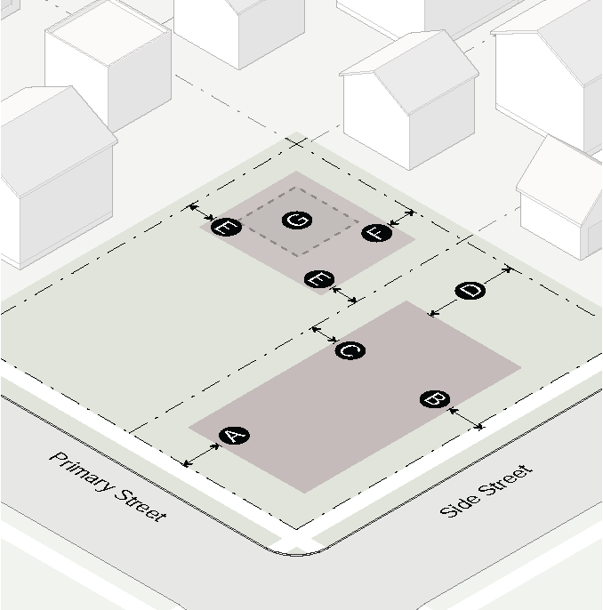
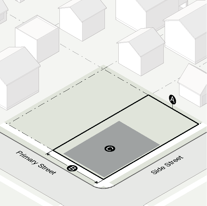
4.1.3. - Lot Dimensions
| Site | |||||||
| Density, units per acre | 18 u/a max | ||||||
| Lot | Area | Width | Depth | ||||
| Detached house | 7,200 SF min | 60' min | 120' min | ||||
| Carriage house | Same as principal structure | ||||||
| Duplex | 9,000 SF min | 70' min | 120' min | ||||
| Attached House | 7,200 SF min | 60' min | 120' min | ||||
| Townhouse | 1,500 SF min | 20' min | 75' min | ||||
| Walk up flat | 4,000 SF min | 40' min | 100' min | ||||
| Stacked flat | 4,000 SF min | 40' min | 100' min | ||||
| Civic building | 5,000 SF min | 40' min | 100' min | ||||
| Lot Coverage | |||||||
| Detached house, carriage house, duplex, attached house or townhouse lot | 40% max/lot | ||||||
| Walk up flat or stacked flat lot | 60% max/lot | ||||||
| Civic building lot | 50% max/lot | ||||||
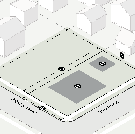
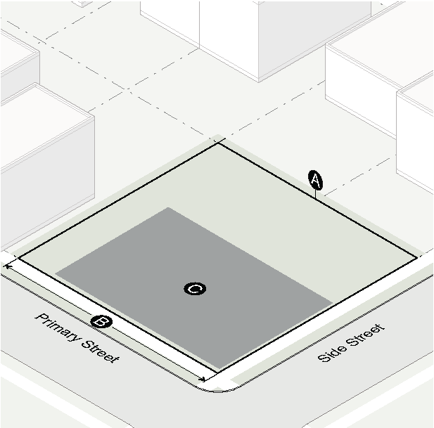
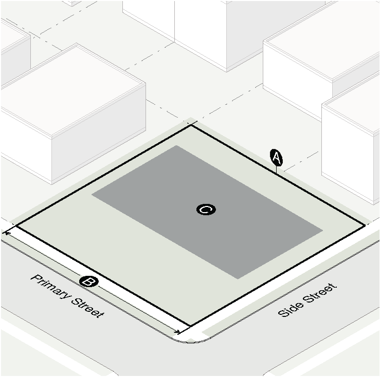
4.1.4. - Building Placement
| Principal Building Setbacks | ||
|---|---|---|
| Primary street | 15' min | |
| Side street | 15' min | |
| Side interior | 5' min | |
| Attached house, townhouse | Interior wall: 0' min Exterior wall: 5' min | |
| All other building types | 5' min | |
| Side interior: abutting residential district | 10' min | |
| Rear | 0' min | |
| Rear: abutting residential district | 30' min | |
| Accessory Structure Setbacks | ||
| Location | Rear yard only | |
| Side street | Level with principal building | |
| Side interior: 1 story/2 story | 3' min/10' min | |
| Rear: 1 story/2 story | 3' min/10' min | |
| Rear/side: alley | 5' or 20' min | |
| Rear yard: coverage | 30% max | |
| Floor area (not including carriage house) | 1,000 SF max | |
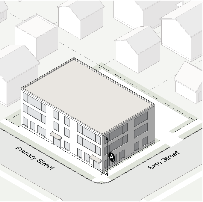
4.1.5. - Bulk and Mass
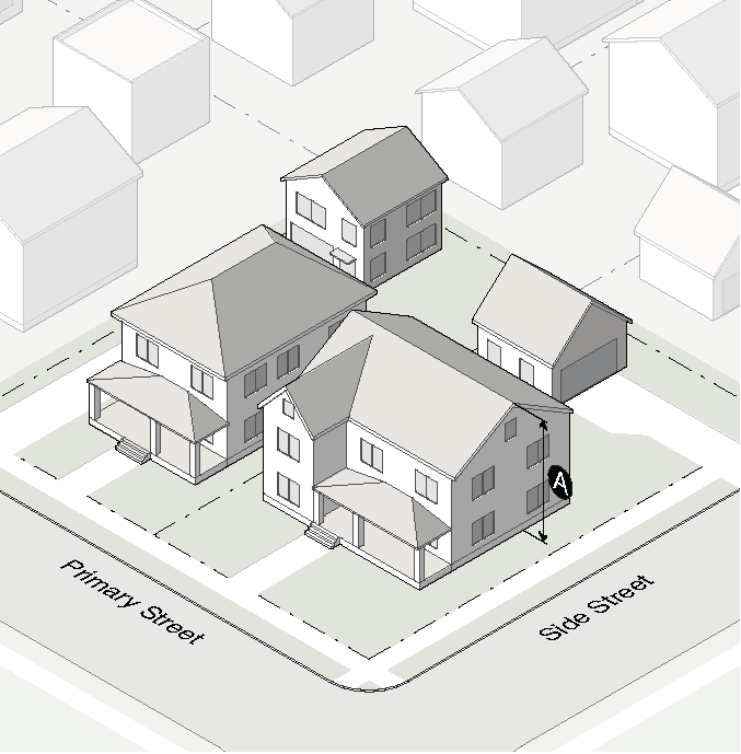
| Building Height | ||
|---|---|---|
| Principal building | 3 stories/35' max | |
| 1 story accessory structure | 16' max | |
| 2 story accessory structure | 25' max | |
| Floor Area Ratio (FAR) | ||
| Detached house, carriage house, duplex, attached house or townhouse lot | .40 max | |
| Walk up flat, stacked flat or civic building lot | n/a | |
4.1.6. - Supplementary Standards
A.
Screening
When a conditional use abuts a lot in a residential district, there shall be provided for the entire distance along the abutting property lines a solid fence of at least 6 feet in height or a landscaped buffer of plant material that will provide a dense, solid screen of at least 6 feet in height within 3 years.
B.
Enclosure
Every use shall be operated within the confines of a completely enclosed structure unless it is approved by the Zoning Administrator as an "open use."
4.2.1. - Purpose
The purpose of this district is to provide for protection and control of development or redevelopment of primarily retail shopping and personal services uses, developed either as a unit or as individual parcels, to serve the commercial needs of a relatively small area, usually a residential neighborhood. Residential density in the building types that allow residential uses shall not exceed 9 units per acre.
(Ord. No. O-15-Z-01, § 1.1, 1-20-15)
4.2.2. - Building Types Allowed
| Single-Story Shopfront | see also Sec. 2.2.3.I. | |
| Mixed Use Shopfront | see also Sec. 2.2.3.J. | |
| General Building | see also Sec. 2.2.3.K. | |
| Civic Building | see also Sec. 2.2.3.L. |
4.2.3. - Lot Dimensions
| Lot | Area | Width | |||
| Single-story shopfront | 5,000 SF min | 50' min | |||
| Mixed use shopfront | 5,000 SF min | 50' min | |||
| General building | 5,000 SF min | 50' min | |||
| Civic building | 5,000 SF min | 50' min | |||
| Coverage | |||||
| Lot coverage | 60% max | ||||
| Site | |||||
| Density, units per acre | 9 u/a max | ||||
(Ord. No. O-15-Z-01, § 1.1, 1-20-15)
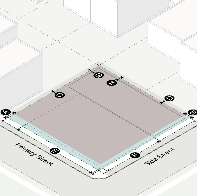
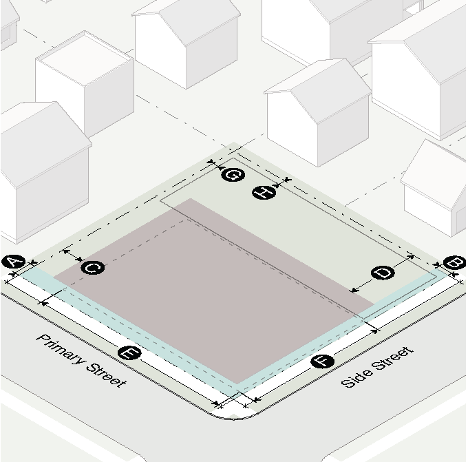
4.2.4. - Building Placement
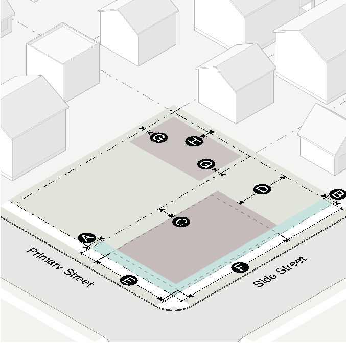
| Principal Building Setbacks | ||
| Primary street build-to zone | 0' min/8' max | |
| Side street build-to zone | 0' min/6' max | |
| Side interior | 0' or 3' min | |
| Side interior: abutting residential district | 10' min | |
| Rear | 0' or 3' min | |
| Rear: abutting residential district | 30' min | |
| Build-To | ||
| Building facade in primary street build-to zone (% of lot width) | 80% | |
| Building facade in side street build-to zone (% of lot width) | 40% | |
| Accessory Structure Setbacks | ||
| Location | Behind principal building | |
| Side street | Level with principal building | |
| Side interior: 1 story/2 story | 3' min/10' min | |
| Rear: 1 story/2 story | 3' min/10' min | |
4.2.5. - Bulk and Mass
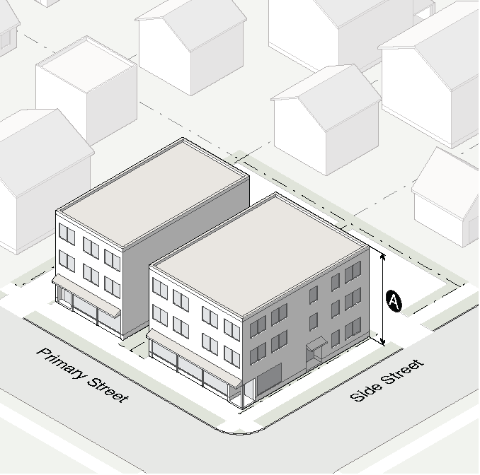
| Building Height | ||
| Principal building | 3 stories/35' max | |
| 1 story accessory structure | 16' max | |
| 2 story accessory structure | 25' max | |
| Building Size | ||
| Maximum floor area per building | 10,000 SF max | |
| Maximum floor area per use | 2,000 SF max | |
4.3.1. - Purpose
The purpose of this district is to provide for protection and control of development or redevelopment of primarily retail shopping and personal services uses, developed either as a unit or as individual parcels to serve the commercial needs of a relatively small area, usually a residential neighborhood. Residential density in the building types that allow residential uses shall not exceed 43 units per acre.
(Ord. No. O-15-Z-01, § 1.2, 1-20-15)
4.3.2. - Building Types Allowed
| Townhouse | see also Sec. 2.2.3.F. | |
| Walk Up Flat | see also Sec. 2.2.3.G. | |
| Stacked Flat | see also Sec. 2.2.3.H. | |
| Single-Story Shopfront | see also Sec. 2.2.3.I. | |
| Mixed Use Shopfront | see also Sec. 2.2.3.J. | |
| General Building | see also Sec. 2.2.3.K. | |
| Civic Building | see also Sec. 2.2.3.L. |
4.3.3. - Lot Dimensions
| Lot | Area | Width | |||
| Townhouse | 800 SF min | 16' min | |||
| Walk up flat | 4,000 SF min | 40' min | |||
| Stacked flat | 4,000 SF min | 40' min | |||
| Single-story shopfront | 5,000 SF min | 50' min | |||
| Mixed use shopfront | 5,000 SF min | 50' min | |||
| General building | 5,000 SF min | 50' min | |||
| Civic building | 5,000 SF min | 50' min | |||
| Coverage | |||||
| Townhouse lot, walk up flat lot | 70% max | ||||
| Stacked flat, single-story shopfront, mixed use shopfront, general building lot | 90% max | ||||
| Civic building lot | 60% max | ||||
| Site | |||||
| Density, units per acre | 43 u/a max | ||||
(Ord. No. O-15-Z-01, § 1.2, 1-20-15)
4.3.4. - Building Placement
| Principal Building Setbacks | ||
| Primary street build-to zone | 0' min/8' max | |
| Side street build-to zone | 0' min/6' max | |
| Side interior | 0' or 3' min | |
| Side interior: abutting residential district | 10' min | |
| Rear | 0' or 3' min | |
| Rear: abutting residential district | 30' min | |
| Build-To | ||
| Building facade in primary street build-to zone (% of lot width) | 80% min | |
| Building facade in side street build-to zone (% of lot width) | 40% min | |
| Accessory Structure Setbacks | ||
| Location | Behind principal building | |
| Side street | Level with principal building | |
| Side interior: 1 story/2 story | 3' min/10' min | |
| Rear: 1 story/2 story | 3' min/10' min | |
4.3.5. - Bulk and Mass
| Building Height | ||
| Principal building | 3 stories/40' max (1) | |
| Minimum building height | 16' min | |
| 1 story accessory structure | 16' max | |
| 2 story accessory structure | 25' max | |
| (1) Special exceptions to the maximum building height may be approved (see Sec. 2.1.6.B.3.) | ||
4.4.1. - Purpose
The purpose of this district is to provide sufficient space for a wide variety of retail sales and service activities serving the entire City and embracing the present central business district. This district is currently built up with a general mixture of retail sales and service activities, government and civic uses. Residential density in the building types that allow residential uses shall not exceed 70 units per acre.
(Ord. No. O-15-Z-01, § 1.3, 1-20-15)
4.4.2. - Building Types Allowed
| Townhouse | see also Sec. 2.2.3.F. | |
| Walk Up Flat | see also Sec. 2.2.3.G. | |
| Stacked Flat | see also Sec. 2.2.3.H. | |
| Single-Story Shopfront | see also Sec. 2.2.3.I. | |
| Mixed Up Shopfront | see also Sec. 2.2.3.J. | |
| General Building | see also Sec. 2.2.3.K. | |
| Civic Building | see also Sec. 2.2.3.L. |
4.4.3. - Lot Dimensions
| Lot | Area | Width | |||
| Townhouse | 800 SF min | 16' min | |||
| Walk up flat | 4,000 SF min | 40' min | |||
| Stacked flat | 4,000 SF min | 40' min | |||
| Single-story shopfront | 5,000 SF min | 50' min | |||
| Mixed use shopfront | 5,000 SF min | 50' min | |||
| General building | 5,000 SF min | 50' min | |||
| Civic building | 5,000 SF min | 50' min | |||
| Coverage | |||||
| Townhouse lot, walk up flat lot | 70% max | ||||
| Stacked flat, single-story shopfront, mixed use shopfront, general building lot | 90% max | ||||
| Civic building lot | 60% max | ||||
| Site | |||||
| Density, units per acre | 70 u/a max | ||||
(Ord. No. O-15-Z-01, § 1.3, 1-20-15)
4.4.4. - Building Placement
| Principal Building Setbacks | ||
| Primary street build-to zone | 0' min/8' max | |
| Side street build-to zone | 0' min/6' max | |
| Side interior | 0' or 3' min | |
| Side interior: abutting R-85, R-60, R-50 | 30' min | |
| Rear | 0' or 3' min | |
| Rear: R-85, R-60, R-50 | 30' min | |
| Build-To | ||
| Building facade in primary street build-to zone (% of lot width) | 80% min | |
| Building facade in side street build-to zone (% of lot width) | 40% min | |
| Accessory Structure Setbacks | ||
| Location | Behind principal building | |
| Side street | Level with principal building | |
| Side interior: 1 story/2 story | 3' min/10' min | |
| Rear: 1 story/2 story | 3' min/10' min | |
4.4.5. - Bulk and Mass
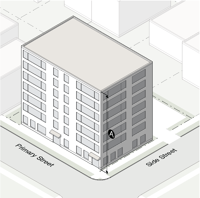
| Building Height | ||
| Principal building | ||
| Townhouse, walk up flat | 40' max (1) | |
| All other building types | 80' max (1) | |
| 1 story accessory structure | 16' max | |
| 2 story accessory structure | 25' max | |
| (1) Special exceptions to the maximum building height may be approved (see Sec. 2.1.6.B.3.) | ||
4.4.6. - Supplemental Standards
A.
Residential Compatibility
1.
Buffer
When C-2 abuts R-85, R-60 or R-50, the yard for the building or use in C-2 cannot be less than 30 feet. When a street separates a building or use in C-2 from an abutting R-85, R-60 or R-50, the street width measured from the R-85, R-60 or R-50 property line shall be considered as part of the required yard. When an alley separates a building or use in C-2 from an abutting R-85, R-60 or R-50 district, the 30 foot yard shall be measured from the commercial property line. The required yard between C-2 and R-85, R-60 or R-50 shall include a minimum 15 foot wide landscaped buffer with a mature, evergreen tree canopy with a 30 foot minimum height if there is no intervening street.
2.
Height Plane
Where a property in C-2 abuts a R-85, R-60 or R-50, no portion of any structure shall protrude through a height limiting plane beginning 35 feet above the boundary of any required yard and extending inward over the C-2 District at an angle of 45 degrees.
3.
Additional Conditions
The following conditions apply when abutting a R-85, R-60 or R-50 District:
a.
No continuous building facade facing residential shall exceed 250 feet in width without a plaza, green space or pocket park at the sidewalk measured from the face of the building with a minimum width and depth of 40 feet.
b.
All buildings shall have vertical expression lines at 40 feet average (change in material or 4 inch depth change) to visually break up solid mass.
c.
Streetscapes facing R-60, R-85 or R-50 streets shall be a minimum of 15 feet in width including a minimum of a 5 foot sidewalk and a minimum 5 foot planting strip.
d.
Portions of the building that face residential uses shall be residential uses within the first vertical 35 feet and the first horizontal 25 feet of the building.
e.
Sufficient, designated visitor parking must be provided on site.
4.
Adjoining Property Meetings
When a proposed development, building or use is adjacent to a R-85, R-60 or R-50 Single Family Residential District line, the property owner and development team will be required to meet a minimum of one time with the adjoining property owners directly impacted by the project. The meeting shall occur prior to submitting for a building permit or meeting with the DDA. Conceptual site plans and conceptual elevations must be made public at least 2 weeks before the meeting. The City will provide facilitation services and criteria for the meeting based on the standards in Sec. 6.1.3.C.
5.
Review by the DDA
Each application for a high-density residential or mixed-use development within the jurisdiction of the DDA must be presented for review before the DDA. The DDA shall issue a resolution stating whether or not the application has met the standards in Sec. 6.1.3.C. Each application shall include a DDA resolution recommending approval or denial of the project as part of the application package prior to the issuance of a building permit.
4.5.1. - Purpose
The purpose of this district is to provide for the control and development of commercial and light industrial uses. The regulations are also intended to protect nearby residential districts. Residential density in the building types that allow residential uses shall not exceed 43 units per acre.
(Ord. No. O-15-Z-01, § 1.4, 1-20-15)
4.5.2. - Building Types Allowed
| Walk Up Flat | see also Sec. 2.2.3.G. | |
| Stacked Flat | see also Sec. 2.2.3.H. | |
| Single-Story Shopfront | see also Sec. 2.2.3.I. | |
| Mixed Use Shopfront | see also Sec. 2.2.3.J. | |
| General Building | see also Sec. 2.2.3.K. | |
| Civic Building | see also Sec. 2.2.3.L. |
4.5.3. - Lot Dimensions
| Lot | Area | Width | |||
| Walk up flat | 4,000 SF min | 40' min | |||
| Stacked flat | 4,000 SF min | 40' min | |||
| Single-story shopfront | 5,000 SF min | 50' min | |||
| Mixed use shopfront | 5,000 SF min | 50' min | |||
| General building | 5,000 SF min | 50' min | |||
| Civic building | 5,000 SF min | 50' min | |||
| Coverage | |||||
| Walk up flat lot | 70% max | ||||
| Stacked flat, single-story shopfront, mixed use shopfront, general building lot | 90% max | ||||
| Civic building lot | 60% max | ||||
| Site | |||||
| Density, units per acre | 43 u/a max | ||||
(Ord. No. O-15-Z-01, § 1.4, 1-20-15)
4.5.4. - Building Placement
| Principal Building Setbacks | ||
| Primary street | 0' min | |
| Side street | 0' min | |
| Side interior | 0' or 3' min | |
| Side interior: abutting R-85, R-60 or R-50 District | 10' min | |
| Rear | 0' or 3' min | |
| Rear: abutting R-85, R-60 or R-50 District | 30' min | |
| Accessory Structure Setbacks | ||
| Location | Behind principal building | |
| Side street | Level with principal building | |
| Side interior: 1 story/2 story | 3' min/10' min | |
| Rear: 1 story/2 story | 3' min/10' min | |
4.5.5. - Bulk and Mass
| Building Height | ||
| Principal building | 45' max (1) | |
| 1 story accessory structure | 16' max | |
| 2 story accessory structure | 25' max | |
| (1) Special exceptions to the maximum building height may be approved (see Sec. 2.1.6.B.3.) | ||
4.5.6. - Supplemental Standards
A.
Landscaping
All front yards and any side yard abutting or facing a residential district shall be suitably landscaped.
B.
Residential District Fence or Buffer Strip
When a use in this district abuts a lot located in a residential district, there shall be provided for the entire distance of the property line or lines a visually solid fence at least 8 feet high or an equivalent buffer strip. The buffer strip shall be planted with plant material of such growth characteristics as will provide a dense obscure planting screen not less than 8 feet in height. Such plant material shall be so maintained as to continue effectiveness as a planting screen.
C.
Fire Safety Hazards
There shall be erected in this district only fire resistive buildings as defined in the building code of the City.
D.
Traffic Congestion and Traffic Noise
Each use shall take such measures to prevent or lessen traffic congestion and the traffic noise generated by vehicles related to its operation as the Planning Commission may reasonably impose. Conditions imposed shall be designated to control the location, number and concentration of vehicles entering or leaving a specific use at the hours of peak traffic flow.
4.6.1. - Purpose and Administration
A.
Purpose
The purpose of the mixed-use district is to promote the redevelopment of existing single uses in commercial areas into vibrant and sustainable mixed-use communities combining residential, retail and office uses; to promote diversity in housing and commercial options; to create walkable, pedestrian-scaled environments that accommodate and encourage multiple modes of transportation; to provide opportunities to add a variety of open space amenities; to provide a framework for shared infrastructure; and to improve the quality of life by providing live, work, and play opportunities based on regulating master site plans developed for a specific area.
B.
Establishing a Mixed-Use District
1.
No MU mixed-use district shall be established without the concurrent approval of a Regulating Master Site Plan by the City Commission following public review and recommendation by city staff and the Planning Commission.
2.
The boundaries of each mixed-use district shall be as shown on the Zoning District Map and Comprehensive Land Use Plan and shall correspond with the adopted Regulating Master Site Plan.
3.
Once adopted, a Regulating Master Site Plan may be modified only after a hearing by the Planning Commission and approval of the City Commission; provided that modifications which do not change the mix or intensity of approved uses, the location or height of buildings, or other significant site features (including, but not limited to, location of streets, drives, parking structures, public spaces) may be approved administratively by the Zoning Administrator. Alterations to the streets and open spaces delineated on a Regulating Plan may be authorized by the Zoning Administrator, upon a finding by the Zoning Administrator that:
a.
Such streets and open spaces are not inconsistent with the purpose and intent of the governing zoning district and the regulating plan; and
b.
Such streets and open spaces provide equal or improved circulation and open space opportunities.
4.
This is the governing ordinance for all mixed-use districts, unless otherwise noted. Any subdivisions, lots consolidations, and replats in a mixed-use district shall conform to the adopted regulating plan for that area.
5.
The minimum size for a mixed-use district is 5 acres.
C.
Application
1.
For the purposes of this Section, where two or more properties, lots or parcels are located within the same block or where two or more properties, lots or parcels have frontage on the same side of the street and are adjoining and such properties, lots or parcels are under common ownership or control and/or are being developed in a single development operation or a series of coordinated development operations, such properties, lots or parcels shall be considered as a single property.
2.
Prior to the issuance of any building permit, the Zoning Administrator shall certify in writing that the proposed development for which such building permit is sought is consistent with all applicable requirements of the district, including the approved Regulating Master Site plan.
3.
Prior to the submittal of an application for a building permit, a pre-application conference between the applicant the Zoning Administrator is required to discuss the application and relevant requirements of these regulations.
4.
Following the pre-application conference, a total of 5 copies of each site plan, landscape plan, and elevation drawing of each exterior building facade shall be submitted, as applicable, and reviewed for compliance by the Zoning Administrator.
5.
All exterior demolition, new construction (including additions to existing buildings), expansions of outdoor dining or any construction which results in increased lot coverage or modification of the building footprint, shall be subject to said pre-application conference and submittal requirements. Routine repair and maintenance and interior improvements are not subject to the pre-application conference.
D.
Regulatory Plan
1.
Summary
A regulatory plan summarizes the maximum contemplated extent of development and gives a realistic indication of the mass, scale, and infrastructure for the district. It is the documented plan illustrating the location of required streets and open spaces to be provided to meet the minimum street and open space requirements The regulating plan must also identify the village subarea and transit station subarea as applicable. The regulatory plan is critical to ensuring that the intent and purpose of the district is implemented specifically as it relates to the provision of the street and open space network. Those streets and open spaces delineated on the regulatory plan shall not be interpreted as the only allowable streets and open spaces within the district as local streets, alleys and open spaces may also be provided in addition to those delineated on the plan.
2.
Documentation
All regulatory plans shall clearly delineate proposed streets and open spaces and corresponding dimensions and written descriptions for each element shall be provided. The regulatory plan shall be required for the pre-application conference and the official submittal of plans to the City. Documentation shall be provided as follows:
a.
Streets
Street documentation shall include the corresponding street classification of each street, the dimensions of the street right-of-way, lane widths, curb-to-curb widths, sidewalk clear zone widths, landscape zone widths and block dimensions.
b.
Open Spaces
Open space documentation shall include the total open space square footage calculation for each individual open space, the net square footage calculation of all open spaces and written description for each individual open space describing the type of each open space, the function of each open space and a general description of the predominant material or feature intended to be used for each open space (i.e. fountain, brick pavers, grass, shrubs, etc.).
c.
Front yards
The front yard for each development site shall be indicated on the regulating plan.
3.
Applicability
Streets and open spaces delineated in the regulatory plan may be permitted to be utilized for meeting the requirements of the governing zoning district. In no case shall the regulatory plan be utilized to permit the noncompliance with the regulations of this district, unless a special exception has been approved by the City Commission.
4.
Density Calculations
Parcels shall be permitted to calculate all future development calculations utilizing existing pre-construction property lines, provided that property owners seeking to calculate said density in this manner shall provide at the time of submission of the required application a sealed property line survey showing all pre-construction and post-construction property lines so as to enable the City to accurately verify said density calculations.
4.6.2. - Subareas Established
To guide the appropriate formation of mixed-use districts, two subareas are hereby established. The intent of each subarea is as follows:
A.
Village Subarea
Medium density residential and commercial uses intended to serve several adjacent neighborhoods.
B.
Transit Station Subarea
Higher density commercial and residential uses adjacent to major transportation corridors and transit nodes intended to serve larger areas of the city and surrounding communities, and provide larger commercial uses with a significant employment concentration.
C.
Use Limitations by Subarea
1.
Village Subarea
An individual, stand-alone building containing a nonresidential use shall be prohibited from exceeding 8,000 square feet of floor area. An individual, stand-alone building with nonresidential uses that are attached to or include a residential use can exceed 8,000 square feet of floor area.
2.
Transit Station Subarea
Individual, stand-alone buildings containing a nonresidential use exceeding 20,000 square feet of floor area shall be separated from each other by a minimum distance of 600 feet as measured from the outside wall closest to the adjacent building. Individual, stand-alone buildings exceeding 20,000 square feet of floor area containing a nonresidential use that are attached to or include a residential use do not require separation from each other.
4.6.3. - Development Standards
A.
Front Yards
Front yards shall have the minimum dimensions as specified in Sec. 4.6.6. The following additional regulations shall apply:
1.
Automobile parking shall be prohibited from being located within the front yard. Parking spaces for one-family dwellings, two-family dwellings and townhouse dwellings shall be on the same lot as the building to be served except as otherwise provided. No parking space shall be permitted in the front yard except on a bona fide paved or graveled driveway leading to a garage, carport, or other permanent parking space located to the rear of the front building line. Circular driveways are prohibited, except for hotels. Except as provided above, paved parking areas will not be permitted between the front building line and the front property line except where a variance permitting such parking has been approved by the Zoning Board of Appeals.
2.
Front yards shall only be used for driveways, landscaping, terraces, porches, stoops, plazas, parks, and walkways.
3.
The area within the front yard which meets open space criteria may be counted towards the open space requirements on a square foot to square foot basis.
B.
Mixed Uses
1.
Residential Requirement
a.
No more than 50% of the total number of dwelling units on the site may be single-family attached dwellings.
b.
On sites with a gross site area greater than 50,000 square feet, at least 20% of the site's total floor area must be residential uses.
2.
Nonresidential Requirement
Development with street frontage along a Regional Boulevard/Downtown Core thoroughfare as defined by the City Community Transportation Plan, shall meet the requirements of Sec. 4.6.5.F. Storefront Requirements, in relation to said street type.
C.
Transitional Heights and Yards
1.
Within the District
There are no requirements for transitional buffers, height planes, or step-backs when both properties in question are located within the district.
2.
Adjacent to the District
When a parcel within the mixed-use district abuts a parcel that lies outside the boundaries of the district, the following conditions will apply:
a.
Minimum Yards
None, except when the MU mixed-use district line abuts a R-85, R-60 or R-50 single-family residential district line, the yard for the building or use in the MU mixed-use district shall not be less than 30 feet. When a street or alley separates a building or use in the MU mixed-use district from an abutting R-85, R-60 or R-50 single-family residential district, half of the street or alley right-of-way width measured from the centerline of the street or alley shall be considered as part of the required yard.
b.
Height Plane
In addition to the minimum yards and buffers required by this Section, where a property in the MU mixed-use district abuts a R-85, R-60 or R-50 single-family residential district line, no portion of any structure shall protrude through a height limiting plane beginning 35 feet above the boundary of any required yard and extending inward over the MU district at an angle of 45 degrees.
c.
Property Outside of Boundary
If the property outside the boundary is zoned for a nonresidential use, then no transitional buffer, height limiting plane, or step-back applies.
D.
Space Dimensions
This district shall have the established dimensions as provided in the following table:
4.6.4. - Open Space
A.
Open spaces shall be provided in conformance with the approved regulating master site plan.
B.
Open space may utilize any of the following elements towards the open space calculation:
1.
Required yards, planted areas, fountains, community gardens, rooftop gardens, parks, plazas, hardscape elements related to sidewalks and plazas, amenity space, and similar features.
2.
Balconies for residential units, which are enclosed on three sides or less, may be counted towards open space requirements.
3.
Required buffer areas may be counted toward open space requirements even if such buffer area is dedicated to the city or other governmental entity for recreation use, conveyed to a conservation group, or is subject to permanent easements for public use.
4.6.5. - Building Design Standards
A.
Facade Orientation
All buildings shall have their primary façade directly fronting and facing a public street.
B.
Fencing Materials
No barbed wire, razor wire, chain-link fence, or similar elements shall be visible from any public plaza, ground level, or sidewalk level outdoor dining area or public right-of-way.
C.
Drive-Through Uses
Drive-through service windows and drive-in facilities are not allowed
D.
Vehicular Services
Gasoline fuel dispenser structures and associated vehicular services such as air pumps and car washes shall not be located between a building and the street.
E.
Building Step Backs
Buildings in excess of 50 feet in height shall be required to step back that portion of the building greater than 50 feet in height a minimum linear distance of 10 feet away from the building facade located below the 50-foot height plane.
F.
Storefront Requirements
1.
Ground-floor nonresidential and noncivic uses shall provide said uses for a minimum depth of 20 feet from the primary building facade along the public sidewalk.
2.
The length of facade without intervening transparency shall not exceed 20 feet.
3.
The ground story shall have a minimum 65% transparency.
4.
Entrances may be counted where they are transparent.
G.
Dumpsters and Loading Areas
Dumpsters and loading areas shall be paved with impervious materials and shall be screened so as not to be visible from any public plaza, sidewalk-level outdoor dining area, public sidewalk or public right-of-way. In addition, dumpsters and loading areas serving residential uses shall be enclosed with opaque walls on three sides not less than 8 feet in height, along with a gate or door.
H.
Loading Dock Entrances for Nonresidential Uses
Loading dock entrances for nonresidential uses shall be screened so that loading docks and related activity are not visible from any public right-of-way.
I.
Building Mechanical and Accessory Features
1.
Shall be located to the side, rear, or roof of the principal structure and shall be in the location of least visibility from the public right-of-way. Screening with plant or fence materials shall be required if the equipment is otherwise visible from the public right-of-way.
2.
When located on rooftops shall be incorporated in the design of the building and screened with building materials similar to the building.
3.
Shall not be permitted between the building and any public street.
(Ord. No. O-17-09, § 2.1, 6-19-17)
4.6.6. - Site Design Standards
A.
Street Requirements
New streets shall be provided in conformance with the district's approved regulating master site plan.
B.
Inter-Parcel Connectivity
Opportunities for inter-parcel pedestrian and vehicle access points between all contiguous commercial, office, or multifamily residential parcels shall be provided.
C.
Gates and Security Arms
Gates and security arms shall be prohibited from crossing any public street or sidewalk.
4.6.7. - Parking Design Standards
A.
Off-Site Parking
Required parking spaces shall be permitted to be provided on adjacent or nearby property within a MU district, provided said relocated spaces lie within 300 feet of the main entrance to the principal use for which such parking is provided.
B.
Driveways and Curb Cuts
1.
All sidewalk paving materials shall be continued across any intervening driveway at the same prevailing grade and cross slope as on the adjacent sidewalk clear zone. A corresponding interior sign or painted bar on the driveway shall be provided adjacent to the sidewalk paving as it intersects the driveway which shall communicate that vehicles must stop or yield for the intervening sidewalk.
2.
Driveway curb cuts shall not be permitted on any street that functions as a regional boulevard/downtown core thoroughfare as defined by the City Community Transportation Plan, when comparable access may be provided from a side or rear street located immediately adjacent to a contiguous property, with the exception of hotel patron drop-off drives.
3.
Except as provided in this Section and for new blocks required by Sec. 8.2.5., no more than one curb cut shall be permitted for each development site, provided that properties with more than one street frontage may have one curb cut located on each street frontage. However, developments on properties with a single street frontage greater than 400 feet shall be permitted two curb cuts along one street frontage.
4.
A common or joint driveway may be authorized by the Zoning Administrator.
C.
Parking Decks and Structures
1.
The ground-floor level of parking decks with primary frontage on a street shall provide only residential, retail, or office uses for a minimum depth of 20 feet from the building facade along the public sidewalk, unless existing topographical considerations render this requirement unreasonable. Entrances to said uses shall be architecturally articulated, and shall face, be visible from, and be directly accessible from the required sidewalk along such street.
2.
Parking deck facades shall conceal automobiles from visibility from any public right-of-way, any private street and any private drive that is open to the general public, and shall have the appearance of a horizontal storied building.
3.
All parking decks and parking structures shall have pedestrian walkways a minimum width of 5 feet connecting ground level parking to the public sidewalks and to all building entrances.
4.
All parking decks and parking structures shall have a landscape strip a minimum width of 6 feet immediately contiguous to the parking facility for the whole of the exterior perimeter of the parking facility, excluding pedestrian and vehicular openings.
(Ord. No. O-17-09, § 2.2, 6-19-17)
4.6.8. - Special Exceptions
Special exceptions to these requirements may be approved after consideration of the following standards:
A.
The suitability of the proposed exception in view of the use and development of adjacent and nearby property.
B.
The effect that the proposed exception will have on the existing use or usability of adjacent or nearby property.
C.
The impact that the proposed development will have on the public safety, traffic on the public streets, transportation facilities, utilities and other public services.
D.
The impact that the proposed development will have on established property values and on the health, safety, comfort and general welfare of the residents of the city.
E.
The economic or marketing impact that these guidelines may have on the property owner or developer.