
Decatur City Zoning Code
ARTICLE 3
- Residential Districts
Sec. 3.8. - Conservation Subdivision (R-85, R-60)
_____
3.1.1. - Purpose
The purpose of this district is to provide for single-family residential development with a minimum lot size of 15,000 square feet, with such public buildings, schools, places of worship, public recreational facilities and accessory uses as may be necessary or are normally compatible with residential surroundings. The district is located to protect existing developments of this character.
3.1.2. - Building types allowed
| Detached House | see also Sec. 2.2.3.A. | |
| Carriage House | see also Sec. 2.2.3.B. | |
| Duplex | see also Sec. 2.2.3.D. | |
| Walk Up Flat | see also Sec. 2.2.3.G. | |
| Civic Building | see also Sec. 2.2.3.L. |
(Ord. No. O-23-Z-01, § 5, 2-6-23)
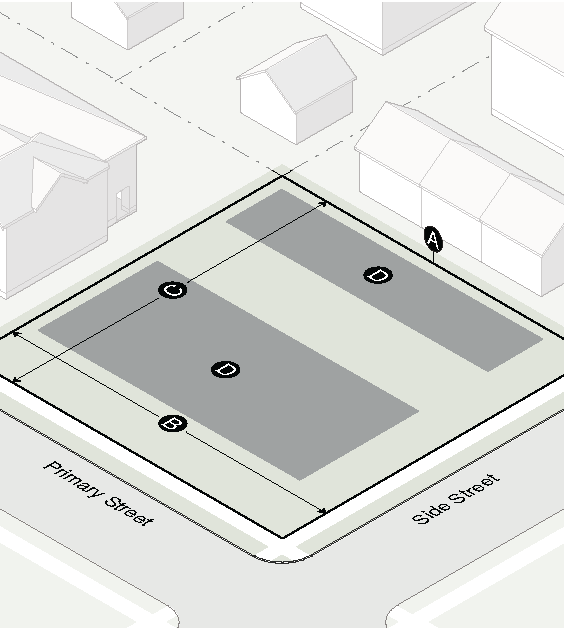
3.1.3. - Lot Dimensions
| Lot | Area | Width | Depth | ||||
| Detached house | 15,000 SF min | 85' min | 150' min | ||||
| Carriage house | Same as principal structure | ||||||
| Duplex | 15,000 SF min | 85' min | 150' min | ||||
| Walk Up Flat | 15,000 SF min | 85' min | 150' min | ||||
| Civic building | 15,000 SF min | 85' min | 150' min | ||||
| Lot Coverage | |||||||
| Detached house lot | 40% max | ||||||
| Duplex lot | 40% max | ||||||
| Walk Up Flat lot | 40% max | ||||||
| Civic building lot | 50% max | ||||||
(Ord. No. O-23-Z-01, § 6, 2-6-23)
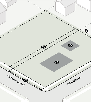
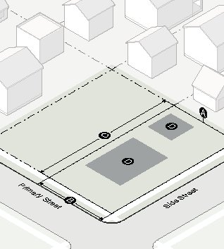
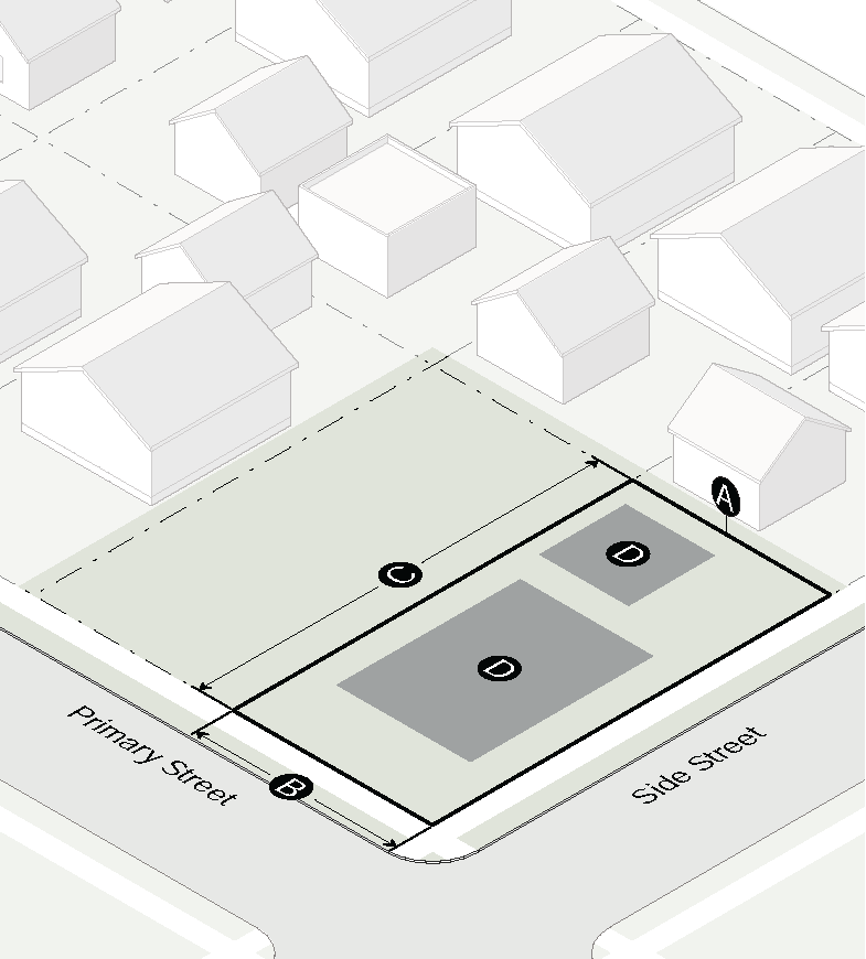
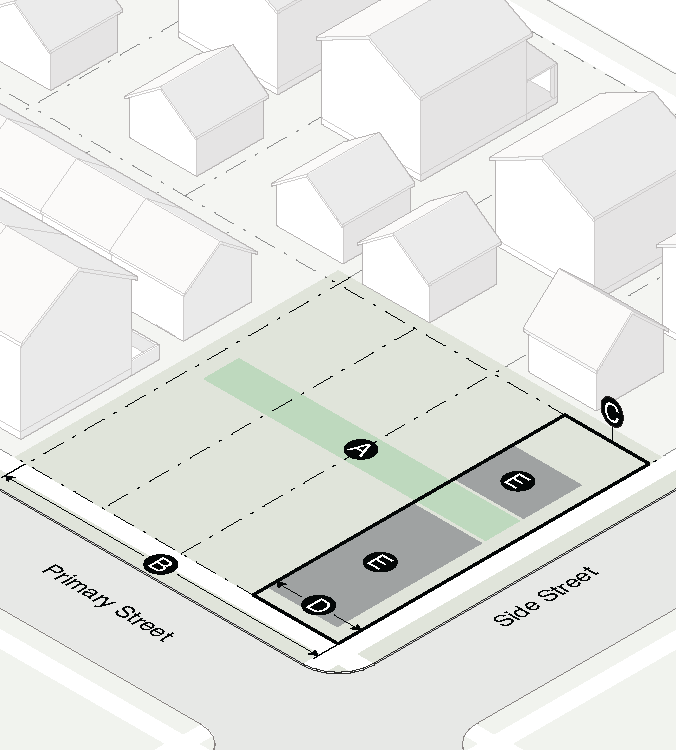
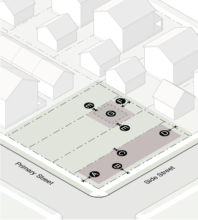
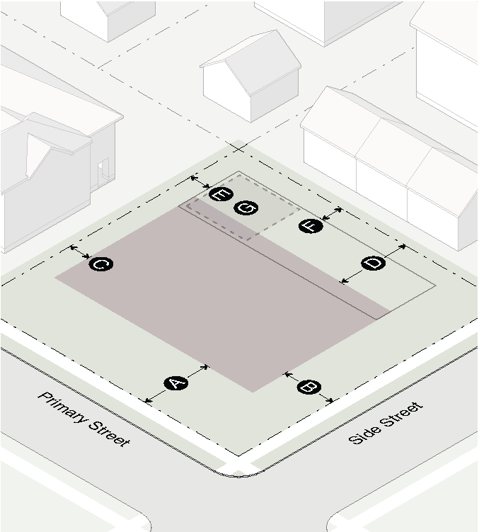
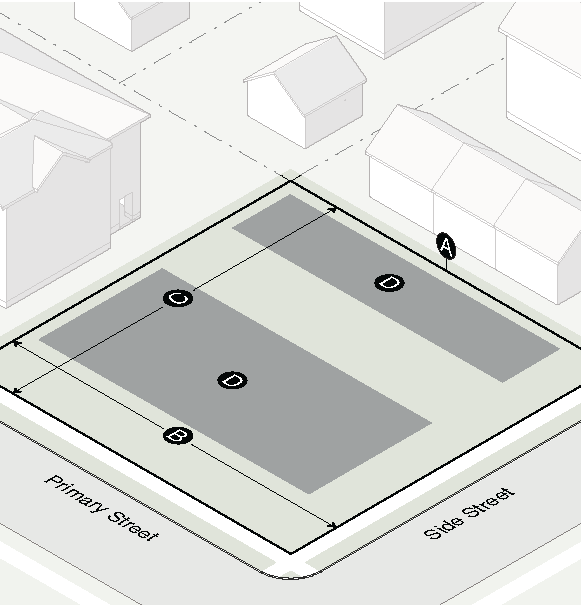
3.1.4. - Building Placement
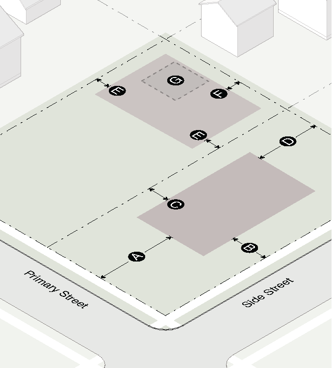
| Principal Building Setbacks | ||
|---|---|---|
| Primary street | 50' min or Avg. front yard (Sec. 2.1.5.B.1.) | |
| Side street | 25' min | |
| Side interior | 15' min | |
| Rear | 40' min | |
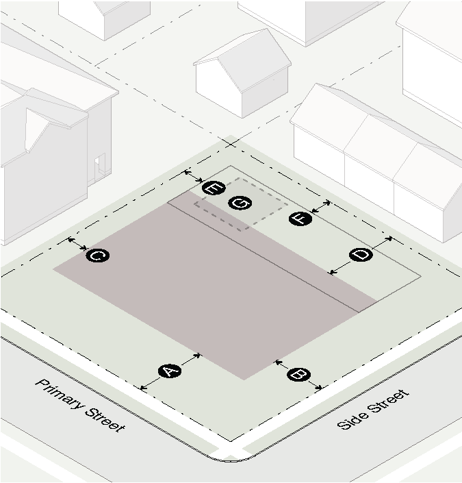
| Accessory Structure Setbacks | ||
| Location | Rear yard only | |
| Side street | 20' min | |
| Side interior: 1 story/2 story | 3' min/10' min | |
| Rear: 1 story/2 story | 3' min/10' min | |
| Rear yard: coverage | 30% max | |
| Floor area (including carriage house) | 1,000 SF max | |
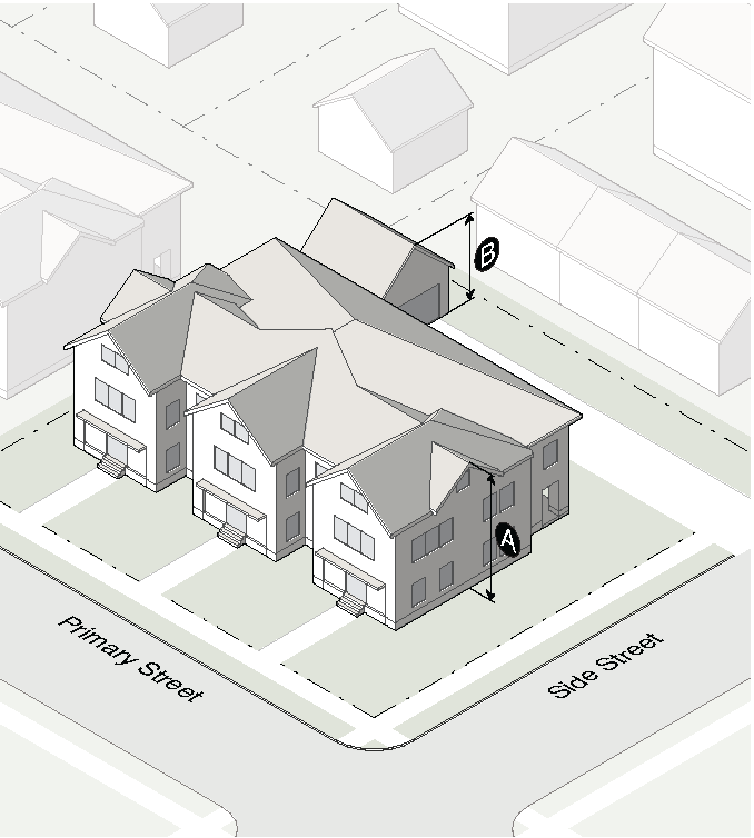
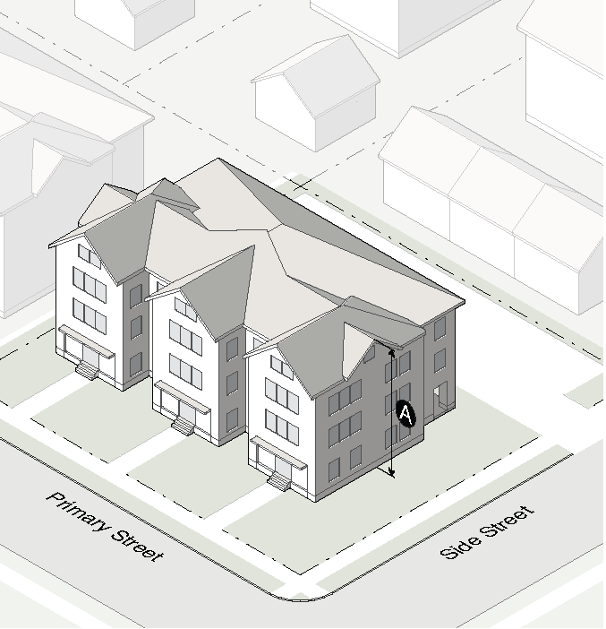
3.1.5. - Bulk and Mass
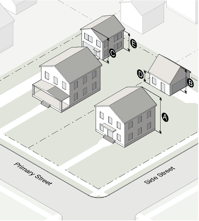
| Building Height | ||
|---|---|---|
| Principal building | 2 stories/35' max | |
| 1 story accessory structure | 16' max | |
| 2 story accessory structure | 25' max | |
| Wall Plate Height (accessory structure only) | ||
| 1 story: pitched roof | 10' max | |
| 1 story: flat roof | 12' max | |
| 2 story: pitched roof | 16' max | |
| 2 story: flat roof | 18' max | |
| Building Mass | ||
| Floor area ratio (FAR) | .40 max | |
3.2.1. - Purpose
The purpose of this district is to provide for single-family residential development with a minimum lot size of 9,000 square feet with such public buildings, schools, places of worship, public recreational facilities and accessory uses as may be necessary or are normally compatible with such surroundings. The district is located to protect existing developments of this character.
3.2.2. - Building Types Allowed
| Detached House | see also Sec. 2.2.3.A. | |
| Carriage House | see also Sec. 2.2.3.B. | |
| Duplex | see also Sec. 2.2.3.D. | |
| Walk Up Flat | see also Sec. 2.2.3.G. | |
| Civic Building | see also Sec. 2.2.3.L. |
(Ord. No. O-23-Z-01, § 7, 2-6-23)
3.2.3. - Lot Dimensions
| Lot | Area | Width | Depth | ||||
| Detached house | 9,000 SF min | 60' min | 120' min | ||||
| Carriage house | Same as principal structure | ||||||
| Duplex | 9,000 SF min | 60' min | 120' min | ||||
| Walk Up Flat | 9,000 SF min | 60' min | 120' min | ||||
| Civic building | 9,000 SF min | 60' min | 120' min | ||||
| Lot Coverage | |||||||
| Detached house lot: | |||||||
| Lot less than 9,000 SF | see Sec. 2.1.4. | ||||||
| Lot 9,000 SF or more | 40% max/lot | ||||||
| Duplex lot: | |||||||
| Lot less than 9,000 SF | see Sec. 2.1.4. | ||||||
| Lot 9,000 SF or more | 40% max/lot | ||||||
| Walk Up Flat lot: | |||||||
| Lot less than 9,000 SF | see Sec. 2.1.4. | ||||||
| Lot 9,000 SF or more | 40% max/lot | ||||||
| Civic building lot | 50% max/lot | ||||||
(Ord. No. O-23-Z-01, § 8, 2-6-23)
3.2.4. - Building Placement
| Principal Building Setbacks | ||
| Primary street | 30' min or Avg. front yard (Sec. 2.1.5.B.1.) | |
| Side street | 10' min | |
| Side interior | 10' min | |
| Lot less than 60' in width | see Sec. 2.1.5.A.6. | |
| Lot 60' or more in width | 10' min | |
| Rear | 30' min | |
| Accessory Structure Setbacks | ||
| Location | Rear yard only | |
| Side street | match main dwelling | |
| Side interior: 1 story/2 story | 3' min/10' min | |
| Rear: 1 story/2 story | 3' min/10' min | |
| Rear yard: coverage | 30% max | |
| Floor area (including carriage house) | 1,000 SF max | |
3.2.5. - Bulk and Mass
| Building Height | ||
| Principal building: | ||
| Lot less than 9,000 SF | see Sec. 2.1.6.B.4 | |
| Lot 9,000 SF or more | 2 stories/35' max | |
| 1 story accessory structure | 16' max | |
| 2 story accessory structure | 25' max | |
| Wall Plate Height (accessory structure only) | ||
| 1 story: pitched roof | 10' max | |
| 1 story: flat roof | 12' max | |
| 2 story: pitched roof | 16' max | |
| 2 story: flat roof | 18' max | |
| Building Mass | ||
| Floor area ratio (FAR) | .40 max | |
3.3.1. - Purpose
The purpose of this district is to provide for newly developed single-family residential development with a minimum lot size of 5,000 square feet with such public buildings, schools, places of worship, public recreational facilities and accessory uses as may be necessary or are normally compatible with such surroundings. The district is located to protect existing developments of this character.
3.3.2. - Building Types Allowed
| Detached House | see also Sec. 2.2.3.A. | |
| Carriage House | see also Sec. 2.2.3.B. | |
| Duplex | see also Sec. 2.2.3.D. | |
| Walk Up Flat | see also Sec. 2.2.3.G. | |
| Civic Building | see also Sec. 2.2.3.L. |
(Ord. No. O-23-Z-01, § 9, 2-6-23)
3.3.3. - Lot Dimensions
| Lot | Area | Width | Depth | ||||
| Detached house | 5,000 SF min | 50' min | 100' min | ||||
| Duplex | 5,000 SF min | 50' min | 100' min | ||||
| Walk Up Flat | 5,000 SF min | 50' min | 100' min | ||||
| Carriage house | Same as principal structure | ||||||
| Civic building | 5,000 SF min | 50' min | 100' min | ||||
| Lot Coverage | |||||||
| Detached house lot | |||||||
| Less than 5,000 SF | see Sec. 2.1.4. | ||||||
| 5,000 to 5,499 SF | 58% max/lot | ||||||
| 5,500 to 5,999 SF | 56% max/lot | ||||||
| 6,000 to 6,499 SF | 54% max/lot | ||||||
| 6,500 to 6,999 SF | 52% max/lot | ||||||
| 7,000 to 7,499 SF | 50% max/lot | ||||||
| 7,500 to 7,999 SF | 47% max/lot | ||||||
| 8,000 to 8,499 SF | 45% max/lot | ||||||
| 8,500 to 8,999 SF | 43% max/lot | ||||||
| 9,000 SF or more | 40% max/lot | ||||||
| Duplex lot | |||||||
| Less than 5,000 SF | see Sec. 2.1.4. | ||||||
| 5,000 to 5,499 SF | 58% max/lot | ||||||
| 5,500 to 5,999 SF | 56% max/lot | ||||||
| 6,000 to 6,499 SF | 54% max/lot | ||||||
| 6,500 to 6,999 SF | 52% max/lot | ||||||
| 7,000 to 7,499 SF | 50% max/lot | ||||||
| 7,500 to 7,999 SF | 47% max/lot | ||||||
| 8,000 to 8,499 SF | 45% max/lot | ||||||
| 8,500 to 8,999 SF | 43% max/lot | ||||||
| 9,000 SF or more | 40% max/lot | ||||||
| Walk Up Flat lot | |||||||
| Less than 5,000 SF | see Sec. 2.1.4. | ||||||
| 5,000 to 5,499 SF | 58% max/lot | ||||||
| 5,500 to 5,999 SF | 56% max/lot | ||||||
| 6,000 to 6,499 SF | 54% max/lot | ||||||
| 6,500 to 6,999 SF | 52% max/lot | ||||||
| 7,000 to 7,499 SF | 50% max/lot | ||||||
| 7,500 to 7,999 SF | 47% max/lot | ||||||
| 8,000 to 8,499 SF | 45% max/lot | ||||||
| 8,500 to 8,999 SF | 43% max/lot | ||||||
| 9,000 SF or more | 40% max/lot | ||||||
| Civic building lot | 50% max/lot | ||||||
(Ord. No. O-23-Z-01, § 10, 2-6-23)
3.3.4. - Building Placement
| Principal Building Setbacks | ||
| Primary street | 20' min or Avg. front yard (Sec. 2.1.5.B.1.) | |
| Side street | 10' min | |
| Side interior | 5' min | |
| Rear | 20' min | |
| Rear, abutting R-85, R-60 | 30' min | |
| Accessory Structure Setbacks | ||
| Location | Rear yard only | |
| Side street | 10' min | |
| Side interior | 3' min | |
| Rear | 3' min | |
| Rear yard: coverage | 30% max | |
| Floor area (including carriage house) | 1,000 SF max | |
3.3.5. - Bulk and Mass
| Building Height | ||
| Principal building | 1.5 stories/30' max | |
| Accessory structure | 16' max | |
| Wall Plate Height (accessory structure only) | ||
| Pitched roof | 10' max | |
| Flat roof | 12' max | |
| Building Mass | ||
| Floor area ratio (FAR) | .40 max | |
3.4.1. - Purpose
The purpose of this district is to provide for single-family residential development at a density not to exceed 17 units per acre.
3.4.2. - Building Types Allowed
| Detached House | see also Sec. 2.2.3.A. | |
| Carriage House | see also Sec. 2.2.3.B. | |
| Cottage Court | see also Sec. 2.2.3.C. | |
| Duplex | see also Sec. 2.2.3.D. | |
| Attached House | see also Sec. 2.2.3.E. | |
| Townhouse | see also Sec. 2.2.3.F. | |
| Walk Up Flat | see also Sec. 2.2.3.G. | |
| Civic Building | see also Sec. 2.2.3.L. |
(Ord. No. O-21-Z-02, § 4.1, 10-18-21; Ord. No. O-23-Z-01, § 11, 2-6-23)
3.4.3. - Lot Dimensions
| Site | |||||
| Density, units per acre | 17 u/a max | ||||
| Amenity space | 5% min | ||||
| Street frontage | 100' min | ||||
| Lot | Area | Width | |||
| Detached house | 5,000 SF min | 50' min | |||
| Carriage house | Same as Detached house | Same as Detached house | |||
| Cottage court | 1,500 SF min | 20 min | |||
| Duplex | 5,000 SF min | 50' min | |||
| Attached house | 2,500 SF min | 25' min | |||
| Townhouse | 1,500 SF min | 20' min | |||
| Walk Up Flat | 5,000 SF min | 50' min | |||
| Civic building | 5,000 SF | 50' min | |||
| Lot Coverage | |||||
| Developments ≤ 20,000 SF | 60% max/lot | ||||
| Developments > 20,000 SF | 75% max/lot | ||||
| Detached house lot | 60% max/lot | ||||
| Cottage court lot | 75% max/lot | ||||
| Duplex lot | 60% max/lot | ||||
| Townhouse | 60% max/site | ||||
| Walk Up Flat lot | 60% max/lot | ||||
| Civic building lot | 50% max/lot | ||||
(Ord. No. O-21-Z-02, §§ 5.1, 5.2, 10-18-21; Ord. No. O-23-Z-01, § 12, 2-6-23)
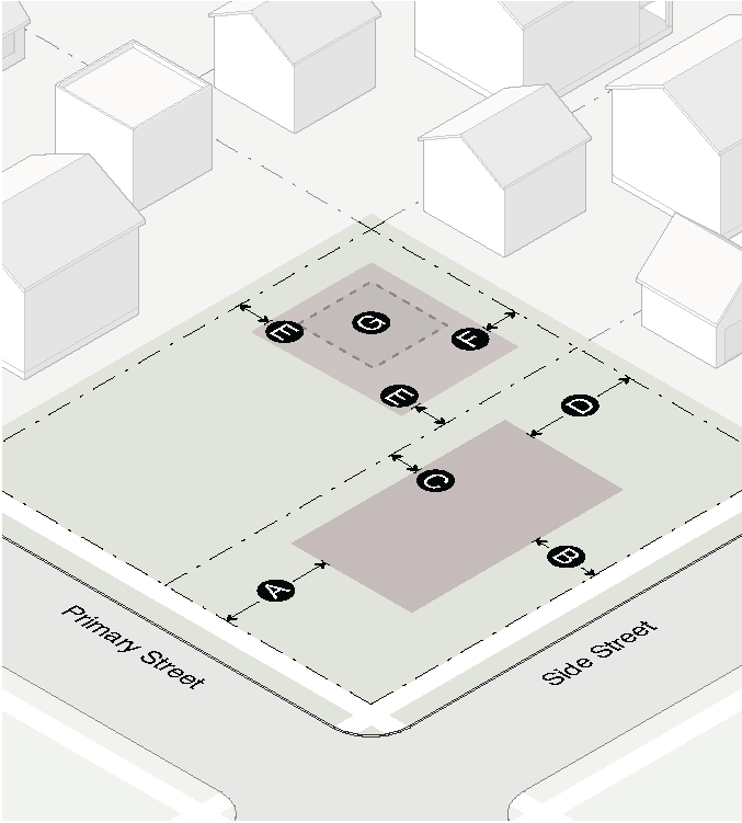
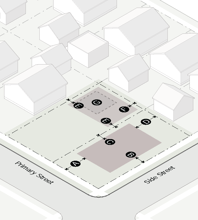
3.4.4. - Building Placement
| Principal Building Setbacks | ||
| Primary street | 5' min or Avg. front yard (Sec. 2.1.5.B.1.) | |
| Side street | 5' min | |
| Side interior |
Interior wall: 0' min
Exterior wall: 3' min | |
| Rear | 5' min | |
| Rear, abutting R-85, R-60 | 30' min | |
| Accessory Structure Setbacks | ||
| Location | Rear yard only | |
| Side street | Level with principal bldg | |
| Side interior: 1 story | 0' or 3' min | |
| Side interior: 2 story | 0' or 10' min | |
| Rear: 1 story | 3' min | |
| Rear: 2 story | 10' min | |
| Rear/side: alley | 5' or 20' min | |
| Rear yard: coverage | 30% max | |
| Floor area (including carriage house) | 1,000 SF max | |
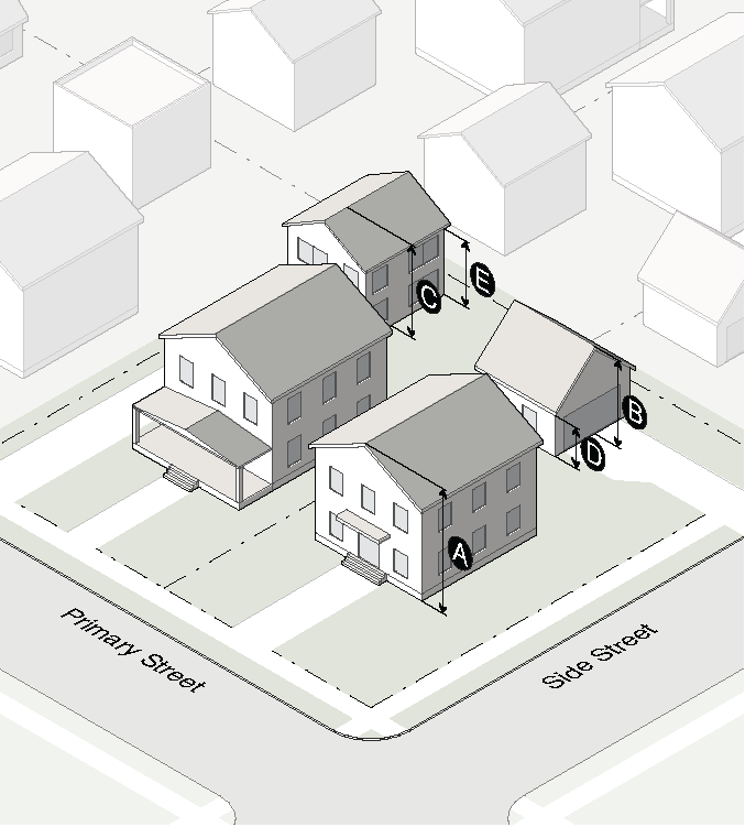
3.4.5. - Bulk and Mass
| Building Height | ||
| Principal building | 3 stories/40' max | |
| 1 story accessory structure | 16' max | |
| 2 story accessory structure | 25' max | |
3.4.6. - Supplementary Regulations
A.
Transitional Buffer
Sites shall have a minimum rear yard of no less than 30 feet where the development adjoins an R-85, R-60 zoning district. No less than 15 feet of the required rear yard shall be preserved as a natural buffer.
B.
Off-Street Parking
1.
No on-site parking is allowed between the principal building and the street.
2.
Garage doors must face the side interior or rear lot line and must be accessed by an alley or driveway.
C.
Garbage and Trash Disposal
Dumpsters must be provided for garbage and trash removal within at least 200 feet of every dwelling unit (measured from the front door along a pedestrian walkway or sidewalk). Dumpsters must be reviewed and approved by the UDO Administrator.
D.
Utilities and Maintenance Facilities
Maintenance facilities, service facilities and public utilities shall be located to prevent visual nuisance within property lines. All utilities (gas, electric, water, sewer, CATV, fuel systems) shall be underground and other facilities shall be screened with plant or fence materials if the equipment is otherwise visible from the public right-of-way.
E.
Post Office Common Mailbox
Adequate provision for a location for delivery of US mail must be made on the site, subject to approval by the US Postal Service.
F.
Building Standards
1.
Acoustics
The acceptable standard for acoustics is 50 decibels, dBa, for interior walls between dwelling units.
2.
Fire Safety
Dwelling units shall comply with Article 10 of the Code of Ordinances of Decatur Georgia: Building and Fire.
G.
Front and Rear Yard Modifications
Special exceptions to the front yard and rear yard requirement may be approved subject to such conditions as may be imposed in order to mitigate impacts which may be expected without the imposition of conditions. The following items shall be considered in determining whether the exception shall be approved:
1.
The uses and rear yard setbacks of adjacent and nearby buildings.
2.
The front-yard and/or rear-yard setbacks of adjacent and nearby buildings.
3.
The impact that the proposed development will have on the light and air of adjacent and nearby properties.
4.
The impact that the proposed development will have on the public safety, traffic on the public streets, transportation facilities, utilities and other public services.
5.
The impact that the proposed development will have on established property values and on the health, safety, comfort and general welfare of the residents of the City.
(Ord. No. O-23-Z-01, § 13, 2-6-23)
3.5.1. - Purpose
The purpose of this district is to maintain medium residential density (not over 18 families per acre) as appropriate for garden-type apartments, and at the same time permit a variety of housing types.
3.5.2. - Building Types Allowed
| Detached House | see also Sec. 2.2.3.A. | |
| Carriage House | see also Sec. 2.2.3.B. | |
| Duplex | see also Sec. 2.2.3.D. | |
| Attached House | see also Sec. 2.2.3.E. | |
| Townhouse | see also Sec. 2.2.3.F. | |
| Walk Up Flat | see also Sec. 2.2.3.G. | |
| Stacked Flat | see also Sec. 2.2.3.H. | |
| Civic Building | see also Sec. 2.2.3.L. |
3.5.3. - Lot Dimensions
| Site | |||||||
| Density, units per acre | 18 u/a max | ||||||
| Lot | Area | Width | Depth | ||||
| Detached house | 7,200 SF min | 60' min | 120' min | ||||
| Carriage house | Same as principal structure | ||||||
| Duplex | 9,000 SF min | 70' min | 120' min | ||||
| Attached House | 7,200 SF min | 60' min | 120' min | ||||
| Townhouse | 1,500 SF min | 20' min | 75' min | ||||
| Walk up flat | 4,000 SF min | 40' min | 100' min | ||||
| Stacked flat | 4,000 SF min | 40' min | 100' min | ||||
| Civic building | 5,000 SF min | 40' min | 100' min | ||||
| Lot Coverage | |||||||
| Detached house, carriage house, duplex or attached house lot | 40% max/lot | ||||||
| Townhouse | 40% max/site | ||||||
| Walk up flat or stacked flat lot | 60% max/lot | ||||||
| Civic building lot | 50% max/lot | ||||||
3.5.4. - Building Placement
| Principal Building Setbacks | ||
| Primary street | 30' min | |
| Side street | 25' min | |
| Side interior | ||
| Attached house, townhouse |
Interior wall: 0' min
Exterior wall: 10' min | |
| All other building types | 10' min | |
| Rear | 30' min | |
| Accessory Structure Setbacks | ||
| Location | Rear yard only | |
| Side street | Level with principal building | |
| Side interior: 1 story/2 story | 3' min/10' min | |
| Rear: 1 story/2 story | 3' min/10' min | |
| Rear/side: alley | 5' or 20' min | |
| Rear yard: coverage | 30% max | |
| Floor area (not including carriage house) | 1,000 SF max | |
3.5.5. - Bulk and Mass
| Building Height | ||
| Principal building | 3 stories/35' max (1) | |
| 1 story accessory structure | 16' max | |
| 2 story accessory structure | 25' max | |
| (1) Special exceptions to the maximum building height may be approved (see Sec. 2.1.6.B.3.) | ||
| Floor Area Ratio (FAR) | ||
| Detached house, carriage house, duplex, attached house or townhouse lot | .40 max | |
| Walk up flat, stacked flat or civic building lot | n/a | |
3.6.1. - Purpose
The purpose of this district is to provide for a variety of residential housing options at density not to exceed 22 units per acre with such public buildings, schools, places of worship, public recreational facilities and accessory uses as may be necessary or are normally compatible with residential surroundings.
3.6.2. - Building Types Allowed
| Detached House | see also Sec. 2.2.3.A. | |
| Carriage House | see also Sec. 2.2.3.B. | |
| Cottage Court | see also Sec. 2.2.3.C. | |
| Duplex | see also Sec. 2.2.3.D. | |
| Attached House | see also Sec. 2.2.3.E. | |
| Townhouse | see also Sec. 2.2.3.F. | |
| Walk Up Flat | see also Sec. 2.2.3.G. | |
| Civic Building | see also Sec. 2.2.3.L. |
3.6.3. - Lot Dimensions
| Site | |||||
| Density, units per acre | 22 u/a max | ||||
| Amenity space | 5% min | ||||
| Lot | Area | Width | |||
| Detached house | 2,500 SF min | 25' min | |||
| Carriage house | Same as principal structure | ||||
| Cottage Court | 1,200 SF min | 20' min | |||
| Duplex | 4,500 SF min | 40' min | |||
| Attached House | 2,500 SF min | 25' min | |||
| Townhouse | 800 SF min | 16' min | |||
| Walk up flat | 4,000 SF min | 40' min | |||
| Civic building | 5,000 SF min | 50' min | |||
| Lot Coverage | |||||
| Cottage court lot | 75% max/lot | ||||
| Townhouse | 60% max/site | ||||
| Civic building lot | 50% max/lot | ||||
| All other lots | 60% max/lot | ||||
3.6.4. - Building Placement
| Principal Building Setbacks | ||
| Primary street | 5' min | |
| Side street | 5' min | |
| Side interior | 0' or 3' min | |
| Rear | 30' min | |
| Accessory Structure Setbacks | ||
| Location | Rear yard only | |
| Side street | Level with principal building | |
| Side interior: 1 story | 0' or 3' min | |
| Side interior: 2 story | 0' or 10' min | |
| Rear: 1 story | 3' min | |
| Rear: 2 story | 10' min | |
| Rear/side: alley | 5' or 20' min | |
| Rear yard: coverage | 30% max | |
| Floor area (not including carriage house) | 1,000 SF max | |
3.6.5. - Bulk and Mass
| Building Height | ||
| Principal building | 3 stories/40' max | |
| 1 story accessory structure | 16' max | |
| 2 story accessory structure | 25' max | |
3.7.1. - Purpose
The purpose of this district is to provide for high-intensity residential use (maximum of 43 families per acre). The districts are so located as to encourage multistory (elevator) apartment development.
3.7.2. - Building Types Allowed
| Detached House | see also Sec. 2.2.3.A. | |
| Carriage House | see also Sec. 2.2.3.B. | |
| Duplex | see also Sec. 2.2.3.D. | |
| Attached House | see also Sec. 2.2.3.E. | |
| Townhouse | see also Sec. 2.2.3.F. | |
| Walk Up Flat | see also Sec. 2.2.3.G. | |
| Stacked Flat | see also Sec. 2.2.3.H. | |
| Civic Building | see also Sec. 2.2.3.L. |
3.7.3. - Lot Dimensions
| Site | |||||||
| Density, units per acre | 43 u/a max | ||||||
| Lot | Area | Width | Depth | ||||
| Detached house | 7,500 SF min | 60' min | 120' min | ||||
| Carriage house | Same as principal structure | ||||||
| Duplex | 9,000 SF min | 70' min | 120' min | ||||
| Attached House | 7,500 SF min | 60' min | 120' min | ||||
| Townhouse | 1,300 SF min | 18' min | 75' min | ||||
| Walk up flat | 4,000 SF min | 40' min | 100' min | ||||
| Stacked flat | 4,000 SF min | 40' min | 100' min | ||||
| Civic building | 5,000 SF min | 40' min | 100' min | ||||
| Lot Coverage | |||||||
| Detached house, carriage house, duplex or attached house lot | 40% max/lot | ||||||
| Townhouse | 40% max/site | ||||||
| Walk up flat or stacked flat lot | 60% max/lot | ||||||
| Civic building lot | 50% max/lot | ||||||
3.7.4. - Building Placement
| Principal Building Setbacks | ||
| Primary street | 30' min | |
| Side street | 25' min | |
| Side interior | ||
| Attached house, town-house |
Interior wall: 0' min
Exterior wall: 10' min + 2' for each story over 2 | |
| All other building types | 10' min + 2' for each story over 2 | |
| Rear | 30' min + 2' for each story over 2 | |
| Accessory Structure Setbacks | ||
| Location | Rear yard only | |
| Side street | Level with principal building | |
| Side interior: 1 story/2 story | 3' min/10' min | |
| Rear: 1 story/2 story | 3' min/10' min | |
| Rear/side: alley | 5' or 20' min | |
| Rear yard: coverage | 30% max | |
| Floor area (not including carriage house) | 1,000 SF max | |
3.7.5. - Bulk and Mass
| Building Height | ||
| Principal building | 45' max (1) | |
| 1 story accessory structure | 16' max | |
| 2 story accessory structure | 25' max | |
| (1) Special exceptions to the maximum building height may be approved (see Sec. 2.1.6.B.3). | ||
| Floor Area Ratio (FAR) | ||
| Detached house, carriage house, duplex, attached house or townhouse lot | .40 max | |
| Walk up flat, stacked flat or civic building lot | n/a | |
3.8.1. - Description
This Section provides for conservation subdivisions in the R-85 and R-60 zoning districts.
3.8.2. - Purpose
A.
To provide for the preservation of greenspace as a nonstructural stormwater runoff and watershed protection measure.
B.
To provide a residential zoning district that permits flexibility of design in order to promote environmentally sensitive and efficient uses of the land.
C.
To preserve in perpetuity unique or sensitive natural resources such as groundwater, floodplains, wetlands, streams, steep slopes, woodlands and wildlife habitat.
D.
To permit clustering of houses and structures on less environmentally sensitive soils which will reduce the amount of infrastructure, including paved surfaces and utility easements, necessary for residential development.
E.
To reduce erosion and sedimentation by minimizing land disturbance and removal of vegetation in residential development.
F.
To promote interconnected greenways and corridors throughout the community.
G.
To promote contiguous greenspace with adjacent jurisdictions.
H.
To encourage interaction in the community by clustering houses and orienting them closer to the street, providing public gathering places and encouraging use of parks and community facilities as focal points in the neighborhood.
I.
To encourage street designs that reduce traffic speeds and reliance on main arteries.
J.
To promote construction of convenient landscaped walking trails and bike paths both within the subdivision and connected to neighboring communities, businesses, and facilities to reduce reliance on automobiles.
K.
To conserve scenic views and reduce perceived density by maximizing the number of houses with direct access to and views of open space.
L.
To preserve important historic and archaeological sites.
3.8.3. - General Regulations
A.
Applicability
This conservation subdivision option is available in the R-85 and R-60 zoning districts. Applicants shall comply with all other provisions of the Unified Development Ordinance and all other applicable laws. Approval of a conservation subdivision is also subject to the requirements of Sec. 11.2.5.
B.
Ownership of Development Site
The tract of land to be subdivided may be held in single and separate ownership or in multiple ownership. If held in multiple ownership, however, the site shall be developed according to a single plan with common authority and common responsibility.
C.
Housing Density Determination
The maximum number of lots in the conservation subdivision shall be determined by either of the following two methods, at the discretion of the Zoning Administrator:
1.
Calculation
The maximum number of dwelling units allowed on a site is calculated by multiplying the net site area by the maximum number of units per acre allowed in the district. Where a conservation subdivision is proposed, the net site area must be reduced to exclude all of the following areas:
a.
Slopes over 15% of at least 2,500 square feet contiguous area;
b.
The 100-year floodplain or regulatory floodplain, whichever is higher;
c.
Bodies of open water over 2,500 square feet contiguous area;
d.
Wetlands that meet the definition of the Army Corps of Engineers pursuant to the Clean Water Act; or,
e.
Anticipated right-of-way needs for roads and utilities.
2.
Yield Plan
The maximum number of lots is based on a conventional subdivision design plan, prepared by the applicant, in which the tract of land is subdivided in a manner intended to yield the highest number of lots possible. The proposed plan must be capable of being constructed given site features and all applicable regulations.
3.8.4. - Application Requirements
A.
Site Analysis Map Required
Concurrent with the submission of a site concept plan, the applicant shall prepare and submit a site analysis map. The purpose of the site analysis map is to ensure that the important site features have been adequately identified prior to the creation of the site design, and that the proposed open space will meet the requirements of this Section. The preliminary site plan shall included the following features:
1.
Property boundaries;
2.
All streams, rivers, lakes, wetlands and other hydrologic features;
3.
Topographic contours of no less than 10-foot intervals;
4.
All primary and secondary conservation areas labeled by type, as described in Sec. 3.8.5.;
5.
General vegetation characteristics;
6.
General soil types;
7.
The planned location of protected open space;
8.
Existing roads and structures; and
9.
Potential connections with existing greenspace and trails.
B.
Open Space Management Plan
An open space management plan, as described in Sec. 3.8.5.E., shall be prepared and submitted prior to the issuance of a land disturbance permit.
C.
Instrument of Permanent Protection
An instrument of permanent protection, such as a conservation easement or permanent restrictive covenant and as described in Sec. 3.8.5.F., shall be placed on the open space concurrent with the issuance of a land disturbance permit in a form acceptable to the UDO Administrator.
3.8.5. - Open Space
A.
Definition
Open space is the portion of the conservation subdivision that has been set aside for permanent protection. Activities within the open space are restricted in perpetuity through the use of an approved legal instrument.
B.
Standards to Determine Open Space
1.
The minimum restricted open space shall comprise at least 40% of the gross tract area.
2.
The following are considered primary conservation areas and are required to be included within the open space, unless the applicant demonstrates that this provision would constitute an unusual hardship and be counter to the purposes of this Section:
a.
The 100-year floodplain or the regulatory floodplain, whichever is higher, in accordance with Sec. 9.5., Floodplain Management/Flood Damage Prevention;
b.
Buffer zones of at least 75 feet width along all perennial and intermittent streams in accordance with Sec. 9.2., Stream Buffer Protection;
c.
Slopes above 15% of at least 2,500 square feet contiguous area;
d.
Wetlands that meet the definition used by the Army Corps of Engineers pursuant to the Clean Water Act;
e.
Populations of endangered or threatened species, or habitat for such species; and,
f.
Archaeological sites, cemeteries and burial grounds.
3.
The following are considered secondary conservation areas and should be included within the open space to the maximum extent feasible:
a.
Important historic sites;
b.
Existing healthy, native forests of at least one acre contiguous area;
c.
Individual existing healthy trees greater than 8 inches caliper, as measured from their outermost drip line;
d.
Other significant natural features and scenic view sheds such as ridge lines, peaks and rock outcroppings, particularly those that can be seen from public roads;
e.
Prime agricultural lands of at least 5 acres contiguous area; and
f.
Existing trails that connect the tract to neighboring areas.
4.
Above-ground utility rights-of-way and small areas of impervious surface may be included within the protected open space but cannot be counted towards the 40% minimum area requirement (exception: historic structures and documented existing trails may be counted). Large areas of impervious surface shall be excluded from the open space.
5.
At least 75% of the open space shall be in a contiguous tract. The open space should adjoin any neighboring areas of open space, other protected areas, and non-protected natural areas that would be candidates for inclusion as part of a future area of protected open space.
6.
The open space shall be directly accessible to the largest practicable number of lots within the subdivision. Non-adjoining lots shall be provided with safe, convenient access to the open space.
C.
Permitted Uses of Open Space
Uses of open space may include the following:
1.
Conservation of natural, archeological or historical resources;
2.
Meadows, woodlands, wetlands, wildlife corridors, game preserves, or similar conservation-oriented areas;
3.
Walking or bicycle trails, provided they are constructed of pervious materials in accordance with the applicable requirements of Article 9;
4.
Passive recreation areas;
5.
Active recreation areas, provided that they are limited to no more than 10% of the total open space and are not located within primary conservation areas. Active recreation areas may include impervious surfaces provided such impervious areas comply with the applicable requirements of Article 9. Active recreation areas in excess of this limit must be located outside of the protected open space;
6.
Agriculture, horticulture, silviculture or pasture uses, provided that all applicable best management practices are used to minimize environmental impacts, and such activities are not conducted within primary conservation areas;
7.
Nonstructural stormwater management practices;
8.
Easements for drainage, access, and underground utility lines; or
9.
Other conservation-oriented uses compatible with the purposes of this article.
D.
Prohibited Uses of Open Space
1.
Golf courses;
2.
Roads, parking lots and impervious surfaces, except as specifically authorized in the previous sections;
3.
Agricultural and forestry activities not conducted according to accepted best management practices; and
4.
Other compatible activities as determined by the applicant and recorded on the legal instrument providing for permanent protection.
E.
Ownership and Management Ownership
The applicant must identify the owner of the open space who is responsible for maintaining the open space and facilities located on the open space. If a homeowner's association is the owner, membership in the association shall be mandatory and automatic for all homeowner's of the subdivision and their successors. If a homeowner's association is the owner, the homeowner's association shall have lien authority to ensure the collection of dues from all members. The responsibility for maintaining the open space and any facilities shall be borne by the owner.
1.
Management Plan
Applicant shall submit a plan for management of open space and common facilities ("plan") that:
a.
Allocates responsibility and guidelines for the maintenance and operation of the open space and any facilities located thereon, including provisions for ongoing maintenance and for long-term capital improvements;
b.
Estimates the costs and staffing requirements needed for maintenance and operation of, and insurance for, the open space and outlines the means by which such funding will be obtained or provided;
c.
Provides that any changes to the plan be approved by the City Commission after a public hearing by the Planning Commission; and,
d.
Provides for enforcement of the plan.
2.
Responsibility
a.
In the event the party responsible for maintenance of the open space fails to maintain all or any portion in reasonable order and condition, the City may assume temporary responsibility for its maintenance and may enter the premises and take corrective action, including the provision of extended maintenance.
b.
The costs of maintenance shall be charged to the owner, homeowner's association, or to the individual property owners that make up the homeowner's association, and may include administrative costs and penalties.
c.
The costs shall become a lien on all subdivision properties.
d.
The exercise by the City of its right to assume temporary maintenance responsibility to take corrective action shall not relieve the property owner of their maintenance responsibility or should it be construed as the City assuming permanent responsibility for such maintenance.
F.
Legal Instrument for Permanent Protection
1.
The open space shall be protected in perpetuity by a binding legal instrument that is recorded with the deed. The instrument shall be one of the following:
a.
A permanent conservation easement in favor of either:
i.
A land trust or similar conservation-oriented non-profit organization with legal authority to accept such easements. The organization shall be bona fide and in perpetual existence and the conveyance instruments shall contain an appropriate provision for retransfer in the event the organization becomes unable to carry out its functions; or
ii.
A governmental entity with an interest in pursuing goals compatible with the purposes of this Section.
iii.
If the entity accepting the easement is not the City, then a third right of enforcement favoring the City shall be included in the easement.
b.
A permanent restrictive covenant for conservation purposes in favor of the City or other governmental entity if approved by the UDO Administrator; or
c.
An equivalent legal tool that provides permanent protection, if approved by the UDO Administrator.
2.
The instrument for permanent protection shall include clear restrictions on the use of the open space. These restrictions shall include all restrictions contained in this Section, as well as any further restrictions compatible with the intent of this article the applicant chooses to place on the use of the open space.