
Dolores City Zoning Code
ARTICLE 6
- Subdivision Standards
Section 6.1.- Purpose.
These subdivision standards are adopted for the following purposes:
A.
To protect and to provide for the public health, safety and general welfare of present and future residents of the Town;
B.
To guide the future growth and development of the Town in accordance with the Comprehensive Plan and other adopted plans and policies;
C.
To ensure provision of adequate public facilities and services for subdivisions;
D.
To provide for the coordinated development of adjoining properties to the benefits of future residents and the general public.
E.
To provide for optimum traffic circulation within the subdivision and throughout the Town;
F.
To ensure protection, sound use and management of natural resources and open spaces through sound development design practices;
G.
To provide for access to open space, recreational facilities and other amenities for all residents; and
H.
To provide reasonable protection from possible nuisances and hazards.
Section 6.2. - Scope and applicability.
A.
Applicability.
1.
This article applies to all plats and subdivision of land within the corporate limits of the Town of Dolores, including property that is being annexed into the Town.
2.
Subdivisions shall be designed to comply with all applicable standards in this Code, including Article 5, Site Layout Standards.
B.
Creation of Building Site.
No building or other development permit shall be issued until a building site, building tract or building lot has been created by compliance with one of the following conditions:
1.
The lot or tract and is part of a plat of record, properly approved by the Board of Trustees and filed in the plat records of Montezuma County, Colorado; or
2.
The parcel, tract, or lot faces upon a dedicated street and was legally created prior to the effective date of the original subdivision regulations of the Town of Dolores or prior to annexation to the Town of Dolores, whichever is applicable, in which event a Building Permit for only one principal building conforming to all the requirements of this Code may be issued on each such original separately owned parcel without first complying with Section 6.2.B.1.
C.
Platting Unzoned Property.
1.
No subdivision plat shall be approved within the Town limits of the Town of Dolores until the area covered by the proposed plat has been assigned a zone district by the Board of Trustees of the Town of Dolores, Colorado.
2.
No subdivision plat shall be approved within any area where a petition or ordinance for annexation or a recommendation for annexation to the Town of Dolores is pending before the Board of Trustees.
3.
In the event the Planning Commission holds a hearing on proposed annexation, it may, at its discretion, at the same time hold a hearing upon the applicable zone district applicable to the area or tract to be annexed and make a recommendation on both matters to the Board of Trustees so that the Board of Trustees can, if it desires, decide the zoning and annexation at the same time.
Section 6.3. - Layout and design, generally.
A.
Natural Hazard Areas.
Land subject to hazardous conditions such as landslides, mud flows, rock falls, snow drifts, possible mine subsidence, mine shafts, shallow water table, open quarries, floods, and polluted or non-potable water supply shall be identified and shall not be subdivided until the hazards have been mitigated or will be mitigated by the subdivision and construction plans.
B.
Adjoining Subdivisions.
A proposed subdivision shall be designed in such a manner as to be coordinated with adjoining subdivisions with respect to the alignment of street rights-of-way, utility and drainage easements, open space, view corridors, and pedestrian/bicycle paths.
Section 6.4. - Building lots.
A.
Lot Configuration.
The lot size, width, depth, shape, and orientation, and the minimum building setback lines shall be appropriate for the location of the subdivision and for the type of development and use contemplated and shall not be less than those specified as minimum standards by the zoning district. The depth and width of properties in mixed-use, commercial, or industrial zone districts shall be adequate to provide for the off-street parking and loading facilities required by the type of use and development contemplated.
B.
Side Lot Lines.
Side lot lines shall be substantially at right angles to street lines unless otherwise approved by the Planning Commission.
C.
Street Frontage Required.
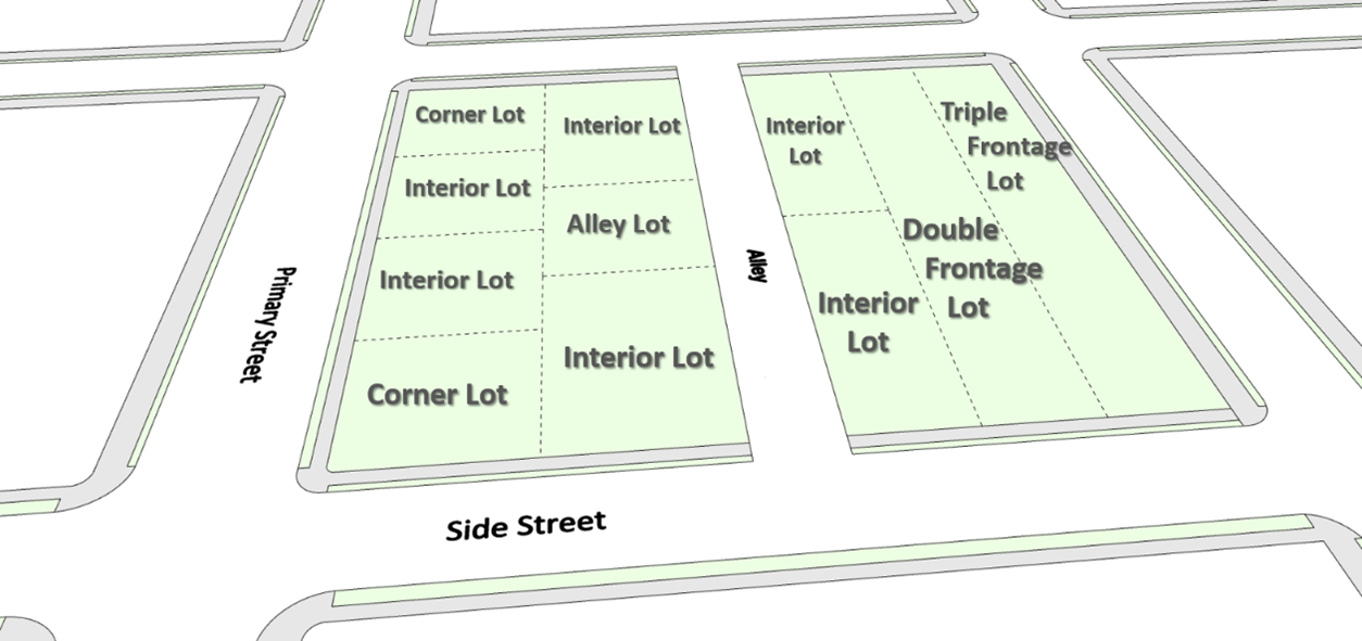
Each lot or building tract shall front on a public street.
D.
Double Frontage Lots.
Double frontage lots shall be avoided, except where essential to provide separation of residential development from traffic or to overcome specific disadvantages of topography and orientation.
E.
Large Lots.
Where the area is divided into larger lots than for normal Town building sites and, in the opinion of the Planning Commission, any or all of the tracts are susceptible of being re-subdivided, the original subdivision shall be such that the alignment of future street dedications may conform to the general street layout in the surrounding area and so that the larger tracts may be later subdivided in conformance with the requirements of this Code and the minimum standards specified by the zoning district.
F.
Floodplain.
No residential lot or parcel intended for residential or nonresidential occupancy shall include any land included within the 100-year floodplain.
Section 6.5. - Streets and alleys.
A.
Specifications.
1.
All streets and alleys shall be designed in accordance with this section, the Dolores Master Streets Plan, as amended, and relevant CDOT standards.
2.
The Town Administrator may grant an exception to one or more street design standards where the standard is inappropriate and the exception will result in the level of safety, service, and quality intended by such standards.
B.
Developer Responsibility.
1.
Perimeter and internal subdivision streets shall be constructed by the developer and dedicated to the Town, along with all necessary right-of-way, with no pro-rata share from the Town.
2.
Major structures, such as retaining walls, box culverts, and bridges that are appurtenant to a proposed street or parking lot construction shall be provided by the developer.
3.
The developer shall pay the cost of purchasing and installing street posts, markers, and traffic signs of the type as used throughout the Town at each street intersection.
4.
The developer shall pay the costs of purchasing and installing all street lighting equipment. All street lighting design plans shall be subject to the approval of the Town Board. The type of equipment, method of installation and location of the wiring and light poles shall meet the minimum standards and requirements of the electric company from which electricity is to be purchased.
C.
Street Layout.
1.
Adequate local streets shall be provided to accommodate the subdivision and provide access to lots.
2.
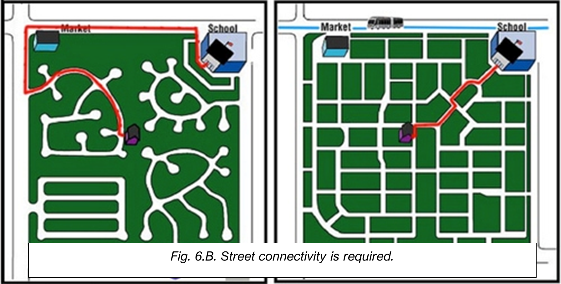
Provision shall be made for street layout, extension and connectivity that bears a logical relationship to the topography and, where applicable, to the location or anticipated location of existing or planned streets on adjacent properties.
3.
Where the layout of streets is not shown in the Dolores Comprehensive Plan, the arrangement of streets in a subdivision shall either:
a.
Provide for the continuation or appropriate projection to existing principal streets in surrounding areas; or
b.
Conform to a plan for a neighborhood or planned unit development approved by the Planning Commission to meet a particular situation where topographical or other conditions make continuance or conformance to existing streets impracticable or where neighborhood design makes a varied plan appropriate.
D.
Street Connections.
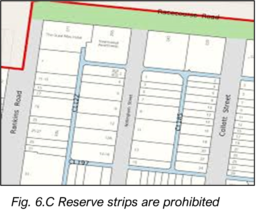
The system of streets designated for the subdivision must connect with streets already dedicated in adjacent subdivision. Where no adjacent connections are platted, street design shall, in general, be the reasonable projection of streets in the nearest subdivided tracts. Streets shall be continued to the boundaries of the tract subdivided to allow connection to other subdivisions.
2.
Reserve strips of land controlling access to or egress from other property or to or from any street or alley or having the effect of restricting or damaging the adjoining property for subdivision purposes shall not be permitted in any subdivision unless such reserve strips are conveyed to the Town in fee simple.
E.
Street Intersections.
1.
All streets shall be laid out to intersect as near as possible to right angles.
2.
All streets shall intersect at right angles for a minimum of 50 feet from the edge of the intersection.
3.
More than two streets intersecting at a point shall be avoided, except where it is impractical to secure a proper street system otherwise and all intersections shall be as near 90 degrees as possible and in no case shall the intersection angle be less than 60 degrees.
F.
Street Jogs.
Non-intersecting streets with centerline offset of less than 125 feet shall not be approved.
G.
Block Lengths.
Block lengths shall not be less than 100 feet or more than 600 feet.
H.
Cul de Sacs and Dead-End Streets.
1.
Permanent cul-de-sacs and dead-end streets should only be used when topography, the presence of natural features, and/or vehicular safety factors make a vehicular connection impractical. Ordinarily, cul-de-sacs shall be discouraged as they do not result in a continuation or conformance to existing streets or streets pattern.
2.
Cul de sacs shall not exceed 600 feet in length and shall have a turnaround diameter of 100 feet. A cul-de-sac of less than 200 in length in a single-family residential area does not require a radial turnaround if the Town Engineer determines that an equally safe and convenient form of turning space is adequate for the vehicles expected to use the cul-de-sac.
3.
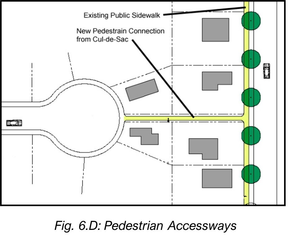
Whenever cul-de-sac streets are created, at least one ten-foot-wide pedestrian access easement shall be provided, to the maximum extent practicable, between each cul-de-sac head or street turnaround and the sidewalk system of the closest adjacent street, pedestrian sidewalk or trail/pathway. (See Figure 6.D: Pedestrian Accessways).
4.
Dead-end streets, except for cul-de-sacs, shall be prohibited unless they are designed to connect with future streets on adjacent lands and that have not been platted. In cases where these types of dead-end streets are allowed, a temporary turnaround of 100 feet shall be constructed.
I.
Half Streets.
Half streets shall be prohibited except where essential to the reasonable development of the subdivision and where the Planning and Zoning Commission finds it will be practicable to require the dedication of the other half of a street when the adjoining property is subdivided.
J.
Street Design Standards.
Street and alley widths, curves, grades design speed and centerline radius shall meet following standards.
1.
Street Grade and Curves.
Streets may have a maximum grade of seven percent. Centerline grade changes with an algebraic difference of more than two percent shall be connected with vertical curves of sufficient length to provide a minimum 200 feet of sight distance. No vertical curve shall be less than 200 feet in length.
2.
Street Curve Radii.
Streets shall have a minimum radius at the centerline of 100 feet, unless in special circumstances the Board of Trustees approves a local residential street with a smaller minimum radius.
3.
Alley Easements Required.
a.
Alley easements shall be provided in all residential areas.
b.
Where there is an existing or planned alley system in a mixed-use or non-residential area, alleys shall be provided and lots shall be provided vehicle access from the alley.
c.
Where an existing or planned alley system does not exist, the Planning Commission may waive the alley easement requirement provided other definite and assured provision is made for safe service access, such as off-street parking, consistent with and adequate for the uses proposed.
4.
Minimum Alley Width.
The minimum right of way width of an alley shall be 20 feet. The minimum improved surface width of alleys shall be 15 feet.
5.
Turn By-Passes and Turn Lanes.
Right-turn by-passes or left-turn lanes may be required at the intersection of collector streets if traffic conditions indicated they are needed. Sufficient right-of-way shall be dedicated to accommodate by-pass or turn lanes when they are required.
6.
Sight Distance.
All portions of the grade line must meet sight distance requirements for the design speed. The minimum stopping sight distance is the distance required by the driver of a vehicle, traveling at the design speed, to bring the vehicle to a stop after an object on the road becomes visible.
7.
Street Names and Numbers.
All street names shall be as established subject to approval of the Planning Commission. When streets are in alignment with existing streets, any new streets shall be named according to the streets with which they correspond. Streets which do not fit into an established street-naming pattern shall be named in a manner which will not duplicate or be confused with existing streets within the Town or its environs. The Building Official shall assign street numbers.
K.
Construction Materials.
All streets shall be constructed with three courses of chip seal (triple chip seal).
Section 6.6. - Sidewalks and pathways.
A.
Sidewalks are required along both sides of all public streets in accordance with Town standards. The minimum width for sidewalks and pathways is five feet.
B.
Provisions shall be made in all developments to encourage the use of bicycle and pedestrian travel through the integration of bicycle and pedestrian paths, trails and/or bicycle lanes that connect to parks, open spaces, schools, public transit, and shopping areas.
C.
Within new residential subdivisions, bicycle and pedestrian paths, trails, and/or bicycle lanes shall also connect to collector and collector streets. Easements and/or rights-of-way shall be provided for bicycle/pedestrian paths between and within developments as necessary to provide pedestrian and bicycle linkages between developments unless the applicant can demonstrate that to do so would be infeasible.
D.
The following standards apply to multifamily, mixed-use, and non-residential development:
1.
A continuous internal pedestrian walkway shall be provided from the perimeter public sidewalk to the principal building entrance.
2.
For multi-structure developments, pedestrian walkways or sidewalks shall connect all primary building entrances and must be provided along any facade featuring an entrance that exits into a parking area or travel lane. Pedestrian walkways shall also connect all on-site common areas, parking areas, storage areas, open space, and recreational facilities.
Section 6.7. - Easements.
A.
Utility Easements Required.
Utility easements shall be provided in all residential areas unless otherwise approved by the Planning Commission and in commercial and industrial districts, except that the Planning Commission may waive the requirement where other definite and assured provision is made for service access consistent with and adequate for the uses proposed.
B.
Minimum Width.
The minimum right of way width of each utility easement shall be 10 feet.
C.
Utility Easements.
Utility easements shall be provided of 10 feet in width on each side of all rear lot lines and five feet in width on each side of side lot lines. Where the rear or side lot lines abut property outside of the subdivision on which there are no rear or side lot line easements at least five feet in width, the easements on the rear and side lot lines in the subdivision shall be 10 feet in width.
D.
Potable Water and Sewer Easements.
Water and sewer easements shall be a minimum of 20 feet in width.
E.
"T" Intersections and Cul-de-Sacs.
Easements 20 feet in width shall be provided in "T" intersections and cul-de-sacs for the continuation of utilities or drainage improvements, if necessary.
F.
Fire Lanes and Emergency Access Easements.
Fire lanes and emergency access easements 20 feet in width shall be provided where required by the Fire Chief.
G.
Drainage Easements.
When a proposed subdivision is traversed by an irrigation ditch or channel, natural creek or stream or a proposed drainage easement, there shall be provided an easement sufficient for drainage and to allow for maintenance of the ditch.
H.
Trail Easements.
When a proposed subdivision is traversed by a public trail shown on an adopted plan or the logical continuation of an existing public trail, an easement shall be provided sufficient for public trail construction, maintenance, and access.
I.
Adjoining Areas.
When easements in areas adjoining proposed subdivisions are necessary to provide adequate drainage thereof or to serve such subdivisions with utilities, the developer shall obtain such easements.
Section 6.8. - Public land dedication.
A.
Purpose.
The requirements for open space, school sites, park and recreational areas contained in this section are intended to ensure that in the Town of Dolores there will be sufficient land dedicated or otherwise set aside to meet the demand and need of the future residents of the development for open space, school sites, and parks, containing passive or active recreational areas that are reasonably attributable to such development.
B.
Applicability.
Every subdivision shall include a dedication of land to the Town, or other entity, as determined by the Board of Trustees, to be used for parks and recreation, open space, school sites, or cash-in-lieu of such dedication in an amount established by this section as a condition of final plat approval and prior to the recording of a final plat.
C.
Dedication Requirement.
1.
The obligation of the developer shall be to dedicate to the Town at least eight percent of the gross land area in fee simple, or other equivalent consideration, unless such a land dedication was required for the subject land at the time of annexation.
2.
If the Board of Trustees finds that park lands proposed to be privately owned and maintained are in the public interest and meet the needs of the neighborhood, up to 75 percent credit toward the dedication requirement otherwise due may be allowed for privately owned, common open space.
D.
Specifications.
1.
Land dedicated or otherwise set aside for open space, school sites and park and recreational areas shall be of such size, dimensions, topography, and general character as is reasonably required for the type of use necessary to meet the demand and need of future residents, e.g., school sites, open space buffer, public trails, active recreation for team or individual sports, playground, tot lot, picnic area, etc.
2.
Unique natural areas or flood prone areas that provide an opportunity for public trails or linkage parks may be included in areas dedicated or otherwise set aside or reserved for open space.
3.
No land dedicated or otherwise reserved in compliance with this section shall have dimensions smaller than 100 feet in width and 150 feet in depth, without the specific approval of the Board of Trustees.
4.
The Town, at its sole discretion, may elect to use the dedicated land for any municipal, school or other public function deemed necessary. Such use shall be compatible with surrounding use.
5.
All lands to be dedicated must have access via a minimum 50-foot right-of-way and also must accommodate connection of all utilities necessary to operate the dedicated land as a public park or recreation area.
6.
Developer and/or owner shall supply signage designating this area as public land. Board of Trustees shall approve the selection and type of signage.
E.
Platting Requirements.
Any land dedicated for open space, school sites, or park and recreational areas shall be shown on the face of a plat submitted for approval by the Planning Commission and Board of Trustees.
1.
Pins to be Installed.
Each corner of the park land to be donated shall be marked with permanent monument consisting of three-fourths (3/4) inch iron pins set in concrete. These shall be located and identified on a recordable land survey completed by a land surveyor registered in the State of Colorado and provided to the Town by Owner and/or developer.
2.
Plat to be Recorded.
Upon approval by the Board of Trustees, said plat shall be filed of record in office of the Montezuma County Clerk and Recorder.
F.
Payment of Cash in Lieu of Dedication.
Payment of cash in-lieu of dedication of land for park and recreational purposes shall be made prior to the recording of a final plat and shall be subject to the following provisions.
1.
Applicability.
In any case in which the subdivision is less than 20 acres, or where the land required to be dedicated or otherwise reserved by this section would be less than one acre, and in all cases in which the Board of Trustees may find that the park and recreational needs of a proposed development would be better served by a park in a different location or the expansion or improvement of an existing park or recreational area, the Board of Trustees shall require a developer or developer to pay the Town of Dolores cash in lieu or to dedicate or convey other equivalent consideration in lieu of applicable cash dedication.
2.
Schedule for Cash in Lieu.
The amount of cash payment required shall be based on the market value of the number of acres that otherwise would be required to be dedicated. The Board of Trustees, following recommendation by the Planning Commission shall, by resolution, set the per-acre fee for dedicated land based upon the current fair market value for raw lands adjacent to the Town of Dolores. The per-acre fee shall be annually updated.
3.
Accounting, Expenditure and Refunds.
All such payments of cash in-lieu fees shall be accounted for and spent according to the following requirements.
a.
Cash in-lieu of payments shall be segregated in a special Parks and Recreation Capital Improvement Fund to be spent on a first in, first out basis and used only for the acquisition and improvements of open space, school sites, and park and recreational areas within the Town of Dolores that will meet the needs of the residents of the development or subdivision in respect of which such payment was made;
b.
Cash in-lieu of payments shall be expended on the park budget, open space acquisition, capital improvements or improvement of open space or park land within reasonable proximity to the proposed development or subdivision from said development or subdivision; and
c.
If cash in-lieu of payments are not expended or unconditionally committed to be expended within 5 years of receipt, the developer shall be entitled to a refund of the amount paid upon written request filed with the Town Clerk within one year after the right to such refund arises.
Section 6.9. - Water supply.
A.
Water supply shall be available or made available to all lots platted. The water system, as proposed, and the availability of the water sources shall be explained and certified by a registered professional engineer licensed in Colorado and an attorney, if necessary, shall substantiate water rights prior to approval of the final plat.
B.
All municipal water service shall be subject to the requirements of the Municipal Code of the Town of Dolores.
C.
All potable water lines, fire hydrants, and appurtenances shall be designed and constructed to meet the currently applicable requirements of the Town of Dolores and the Dolores Fire Protection District. Fire hydrants shall be provided to serve new subdivisions sufficient to maintain a Class 3 fire rating by the Insurance Service Office ("ISO").
Section 6.10. - Sanitation.
All sanitary sewer service and facilities shall be provided by and meet all requirements of the Town of Dolores.
Section 6.11. - Underground utilities.
All utilities shall be placed underground, except transformers, switching boxes, and terminal boxes.
Section 6.12. - Mandatory homeowners' association.
A.
Applicability.
When a residential subdivision contains any physical facilities, structures, improvements, systems, areas or grounds held in common and necessary or desirable for the welfare of the area or subdivision, or that are of common use or benefit and that are not or cannot be satisfactorily maintained by the Town or another public agency, the Town may require the establishment and creation of a mandatory homeowners' association to assume and be responsible for the continuous and perpetual operation, maintenance and supervision of such facilities, structures, improvements, systems, areas or grounds.
B.
Responsibilities.
Such mandatory homeowners' associations shall be responsible for the continuous and perpetual operation, maintenance and/or supervision of landscape systems, features or elements located in parkways, common areas, between screening walls or living screens and adjacent curbs or street pavement edges, adjacent to drainageways or drainage structures or at subdivision entryways. Subdivision entryway treatments or features shall not be allowed unless a mandatory homeowners' association is established and created.
C.
Dedications to Association.
All facilities, structures, improvements, systems, areas, or grounds, that are to be operated, maintained and/or supervised by a mandatory homeowners' association, other than those located in public easements or rights-of-way, shall be dedicated by easement or deeded in fee simple ownership interest to the association. Easements or ownership shall be clearly identified on the final plat of the applicable subdivision.
Section 6.13. - Condominium subdivisions.
Condominium subdivisions shall comply with the following standards:
A.
The density of the development shall not be greater than the maximum density as allowed by the underlying zone district.
B.
Each individual condominium unit shall have separate utility service, including individual meters and shut-off valves.
C.
The structure shall meet current off-street parking requirements for the underlying zone district. Each residential condominium unit shall be considered a separate dwelling unit for purposes of determining parking compliance.