
Dolores City Zoning Code
ARTICLE 9
- Hazardous and Environmentally Sensitive Areas.
Section 9.1.- Geologic hazards.
A.
Purpose and Intent.
1.
The Town of Dolores is located within areas that are susceptible to one or more geologic hazards occurring either on the property or upstream/uphill from the property that would impact the subject property. Below is a list of common geologic hazards found in Dolores; however, this list is not exhaustive:
a.
Expansive or unstable soils and/or rock;
b.
Unstable or potentially unstable slopes;
c.
Landslide or laterally unstable areas or potential landslide areas;
d.
Flood inundation, debris flows, and debris fans;
e.
Unstable fill;
f.
Erosion and deposition areas, or highly erodible soils;
g.
Rockfall;
h.
Subsidence;
i.
Shallow water tables;
j.
Groundwater springs or seeps;
k.
Flood-prone areas;
l.
Collapsible soils;
m.
Faults;
n.
Upturned or steeply dipping bedrock;
o.
Radioactivity or radon;
p.
Problems caused by features or conditions on adjacent properties; and
q.
Other general geologic or site problems.
2.
The Town recognizes that geologic hazards can be interrelated, and that evaluation of geologic hazards requires comprehensive review and analysis. The Town and Montezuma County retain geologic hazards maps that are prepared and updated from time to time. Such maps shall be considered for initial review of site hazards prior to site evaluation. The geologic hazards identified in the proposed development site on the geologic hazard maps shall be discussed in the geologic hazard assessment.
3.
Further, these standards are intended to minimize losses due to geologic conditions in the Town, and to:
a.
Protect human life, safety, and property;
b.
Provide the Town with an efficient review procedure to address potential hazards;
c.
Minimize damage to adjacent private property;
d.
Minimize damage to public facilities, infrastructure, and utilities;
e.
Provide flexible approaches to evaluating geologic hazards risk;
f.
Reduce the amount of effort and expenditures associated with response, cleanup, and repair following a geologic hazard event; and
g.
Inform the public about the potential risk associated with geologic hazards in Dolores.
B.
Tiered Evaluation and Review Purpose.
The review and evaluation of potential geologic hazards is undertaken through a three-tier process that generally follows the process described in this flow chart. Each tier has a specific purpose, as identified below.
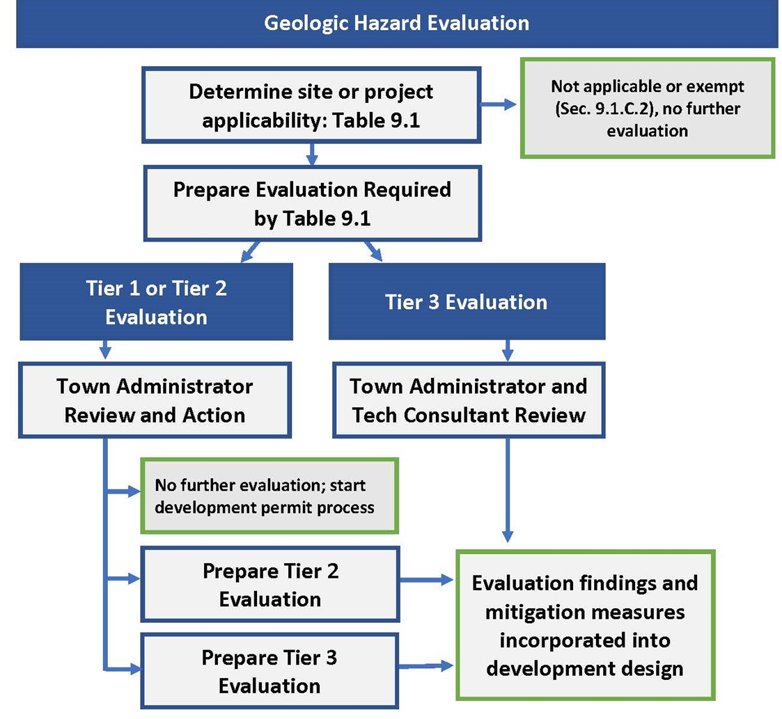
1.
Tier 1, Initial Site Evaluation Letter: To provide initial evaluation of potential geologic hazards concerns related to development activities.
2.
Tier 2, Geologic Hazards Mitigation Study: To provide further evaluation of geologic hazards for development activities of certain sites and to provide review and recommendations of proposed mitigation for identified hazards.
3.
Tier 3, Geologic Hazards Plan and Report: To accomplish the following:
a.
Identify the geologic hazards affecting the development site;
b.
Assess proposed development that could pose a more significant geologic hazard impact;
c.
Analyze potential geologic hazard impacts the proposed development could have on surrounding properties or public facilities;
d.
Identify appropriate mitigation measures that shall be employed to reduce or avoid the identified hazards to acceptable levels so that development may proceed; and
e.
Recommend areas that are not suitable for the proposed development or that pose unacceptable risks for development.
C.
Applicability and Exemptions.
1.
Applicability.
a.
The geologic hazards standards and evaluation requirements in this section shall apply to any of the following activities or scenarios unless the activity is identified as exempt in Section 9.1.C.2:
2.
Exemptions.
The following types of development activities are exempt from Geologic Hazards Evaluation in this section but are still subject to other applicable site evaluation processes and standards. An exemption from these standards does not exempt the applicant from liability and responsibility to evaluate and mitigate known geologic hazards on a site.
a.
Minimum impact installations such as fences, lighting, poles, signs, or decorations;
b.
Movement or parking of machinery or equipment; or
c.
Installation of decorative or perimeter walls that do not serve to retain soil, unless supporting a load or other weight surcharge.
3.
Existing Geologic Hazard Studies.
Sites with existing studies or reports that were certified and stamped by licensed geologists and that are 10 years or older shall be subject to the Tier 1 Initial Site Evaluation Letter procedure below to determine whether the existing study or report is sufficient for the proposed development application, or if changes in conditions warrant a new Tier 2 or Tier 3 evaluation.
4.
Timeframe.
Applications and permits for additions and alterations shall remain on record with the Town. Any subsequent application or permit for an addition or alteration on the same property shall be cumulative to any application or permit within a five-year period, and the total square footage of such additions or alterations shall be used to determine the applicability of these standards.
D.
Tiered Evaluations.
1.
Applicability and Submission Requirements.
a.
Applicants shall submit an initial evaluation at the Tier specified in Table 9-1 as part of the application that triggers the evaluation requirement. Where no application type is specified, the evaluation shall be submitted with either:
(1)
Section 13.12, Grading and Erosion Control Permit; or
(2)
Section 13.23, Site Plan application.
b.
An applicant who is required to submit a Tier 1 Evaluation Letter may, at their discretion, proceed directly to a Tier 2 or Tier 3 geologic hazard evaluation. If the applicant moves directly to a Tier 2 evaluation, they assume the risk that a Tier 3 evaluation may also be required.
c.
Projects for which a Tier 2 or Tier 3 geologic hazard evaluation are required shall also be required to enter into a Section 13.4.G.4, Development Agreement and Performance Guarantee.
2.
Tier 1 and Tier 2 Evaluation Review Procedures.
a.
Process.
(1)
Unless otherwise specified in Table 9.1, an applicant shall submit a Tier 1 evaluation for review. Based on the findings and recommendations of the site evaluation and letter, the Town Administrator, may:
i.
Move the application or permit forward through the applicable approval procedure; and/or
ii.
Require a soils and foundation report.
(2)
Following further review of the letter and any subsequent input stated above, the Town Administrator may:
i.
Move the application or permit forward through the applicable approval procedure;
ii.
Require a Tier 2 Evaluation: Geologic Hazards Mitigation Study; or
iii.
Require a Tier 3 Evaluation: Geologic Hazards Plan and Report.
b.
Responsibility and Consultant Fees.
(1)
The administration of geologic hazard evaluations shall be done by the Town Administrator who may delegate the administration as needed.
(2)
The Town Administrator may use the services of a consulting geologist or geotechnical engineer ("technical professional") and the Colorado Geological Survey (CGS) to assist with any application evaluation. Technical professional review is required for Tier 3 Evaluations.
(3)
The applicant is responsible for reimbursing the Town for any costs associated with technical professional and/or CGS review. The Town may pause or stop processing any application for which the applicant has not made timely reimbursement of technical professional fees or expenses.
3.
Tier 2 and Tier 3 Evaluation Review Procedures.
a.
During the Sec. 13.4, Step 3: Staff Review and Report for the associated permit or land development application, the Tier 2 or Tier 3 report shall be reviewed by the Town Administrator, in consultation with a qualified professional geologist or geotechnical engineer, and as part of the review of the associated land development application. The Zoning Administrator shall forward the Geologic Hazard Plan and Report to the Colorado Geological Survey (CGS) for review and comment. The Town's review shall determine whether the findings, conclusions, and recommendations of the Geologic Hazard Plan and Report and comments from CGS have been incorporated into the project, grading, infrastructure, or other relevant design aspect of the proposed project. If the Town review determines that the submitted study is incomplete or fails to comply with the standards and requirements set forth in this section, the Zoning Administrator may require new or supplemental information.
b.
Recommendations of the Geologic Hazards Plan and Report shall be incorporated, as applicable, into the project, grading, infrastructure, or building, other relevant design aspect of the proposed project.
4.
Review.
a.
Any application request that includes submission of a Tier 2 Geologic Hazards Mitigation Study or Tier 3 Geologic Hazards Plan and Report shall be reviewed by the PZC and decided-upon by the Board of Trustees. Both the PZC and Board of Trustees shall hold a public hearing on the application.
b.
The Town Administrator's review of Tier 1 and Tier 2 application for the purpose of determining whether more information is necessary to fully review the project is not an appealable decision, but rather a step in assessing compliance with the Town's complete application requirement.
5.
Independent Review.
The Town Administrator, Planning Commission, or Board of Trustees may, at their discretion, have any geologic hazard evaluation (Tier 1, 2, or 3) reviewed by an independent qualified professional geologist or a qualified professional geotechnical engineer. This separate review shall supplement the Town's review and will be considered by the Town in making a final determination on the associated land development proposal. The cost of having an independent review and analysis of geologic hazard evaluation reports shall be borne by the applicant.
6.
Evaluation Content.
a.
Tier 1 Evaluation Letter. Following the site evaluation, the qualified professional geologist or a qualified professional geotechnical engineer shall submit a signed and stamped letter providing details of the site evaluation. At a minimum, the letter shall:
(1)
Include the date and location of the site visit;
(2)
Include photos of the lot and any geologic hazard conditions;
(3)
Include a detailed narrative description of the lot conditions, including slopes; evidence of drainage and any other potential hazards on the site;
(4)
Confirm that Montezuma County and/or Dolores' geologic hazard maps were reviewed in relation to the site;
(5)
Provide initial recommendations, if any, to mitigate the potential geologic hazard conditions;
(6)
Determine whether or not the proposed development activity for the site would result in an increased risk to geologic hazards on the site or on adjacent properties; and
(7)
Provide an assessment and recommendation whether or not further study is required through a Tier 2 or Tier 3 Evaluation to address geologic hazard risk.
b.
Tier 2 Geologic Hazards Mitigation Study:
(1)
The applicant shall submit a study and report of potential mitigation solutions ("Mitigation Study") that lessen the impact of the proposed development activity on the site and on adjacent properties. Such study shall:
i.
Be prepared by a qualified professional geologist or a qualified professional geotechnical engineer;
ii.
Identify potential geologic hazards on the site;
iii.
Identify conditions that may pose a hazard to land development activities on the site and on adjacent properties;
iv.
Describe proposed mitigation strategies and how they will reduce or avoid identified hazards;
v.
Describe how the proposed mitigation strategies will reduce or avoid identified hazards on adjacent public or private property;
vi.
Describe how the proposed mitigation strategies will comply with any required soils, foundation, or drainage and erosion control plans, or other applicable engineering standards; and
vii.
Include applicable calculations to support proposed mitigation strategies.
(2)
Mitigation Measures: In cases where geologic hazards are identified, appropriate mitigation measures shall be identified in the Mitigation Study and may be required in conjunction with the approval of the project, if approval is recommended. Such mitigation measures may include, but not be limited to:
i.
Changes to the proposed land use configuration;
ii.
Changes to the location of proposed structures;
iii.
Modification of land use types;
iv.
Modification of lot boundaries;
v.
Establishment or modification of building envelopes;
vi.
Special foundation designs and over-excavation;
vii.
Mitigation of rockfall and/or debris flow;
viii.
Grading, drainage, and erosion controls;
ix.
Geotechnical engineering solutions; and
x.
Limitations on irrigated landscapes.
c.
Tier 3 Geologic Hazards Analysis. A Geologic Hazards Plan and Report, when required, shall be prepared by a qualified professional geologist or a qualified professional geotechnical engineer. The Geologic Hazards Plan and Report shall address the topics listed in this subsection, where applicable. The level of detail and emphasis may vary due to specific geologic conditions of the site or the scale and type of proposed development activity. The detailed guidelines, criteria, policies, and requirements for preparation, submittal, and review of the Geologic Hazards Plan shall be determined during an initial scoping process between the applicant and the Town.
(1)
General Project Description and Certification.
(a)
A project description shall be included that presents the overall proposed project details including the size and location of the project and the existing and proposed land uses.
(b)
The qualified professional geologist or qualified professional geotechnical engineer preparing or certifying the Plan and Report shall sign and stamp the Plan and Report.
(2)
Geologic Hazard Risks. The presence of any geologic hazards on the site.
(3)
Proposed Cuts.
(a)
Prediction of what materials and structural features will be encountered;
(b)
Prediction of stability based on geological factors;
(c)
Problems of excavation (e.g., unusually hard or massive rock, excessive flow of groundwater); and
(d)
Recommendations for reorientation or repositioning of cuts, reduction of cut slopes, development of compound cut slopes, special stripping above daylight handling of seepage water, setbacks for structures above cuts, etc.
(4)
Proposed Masses of Fill.
(a)
General evaluation of planning with respect to canyon-filling and side hill masses to fill;
(b)
Comment on suitability of existing natural materials for fill; and
(c)
Recommendations for positioning of fill masses, provision for underdrainage, buttressing, and special protection against erosion.
(5)
Recommendations for Subsurface Testing and Exploration.
(a)
Cuts and test holes needed for additional geological information; and
(b)
Program of subsurface exploration and testing, based upon geological considerations that are most likely to provide data needed by the soils engineer.
(6)
Conclusions and Recommendations. The Geologic Hazard Plan and Report shall address the following:
(a)
Whether the intended use of the land is compatible with any identified or potential geologic hazards or constraints;
(b)
The development of mitigation procedures or design changes necessary to minimize or abate any hazardous condition and whether such mitigation or design change is possible. Each hazardous condition requires a recommendation, which may be a recommendation that the conditions are too severe to warrant development;
(c)
The long-term stability and safety of the proposed project. Discuss the critical planning and construction aspects of the development, including the suitability of using irrigated landscaping, the stability of earth materials, the appropriateness of the proposed grading plans, the need for selective location of project facilities, and the static and dynamic parameters for the design of structures; as applicable; and
(d)
Clearly state the geologic basis for all conclusions.
d.
Mitigation Measures. In cases where geologic hazards are identified, appropriate mitigation measures shall be identified in the Geologic Hazard Plan and Report and may be required in conjunction with the approval of the project, if approval is recommended. Such mitigation measures may include, but not be limited to:
(1)
Changes to the proposed land use configuration;
(2)
Changes to the location of proposed structures;
(3)
Modification of land use types;
(4)
Modification of lot boundaries;
(5)
Establishment or modification of building envelopes;
(6)
Special foundation designs and over-excavation;
(7)
Mitigation of rockfall and/or debris flow;
(8)
Grading, drainage, and erosion controls;
(9)
Geotechnical engineering solutions; and
(10)
Limitations on irrigated landscapes.
Section 9.2. - Ridgeline hazard standards.
A.
Applicability.
This section shall apply to the development of all property within one mile of the Dolores town boundaries, except as otherwise specified.
B.
Hazard Areas.
Development of lands located above and within one-quarter (1/4) mile of the top of Dolores Canyon escarpment or cliff shall avoid site alteration, use of septic systems, or the addition of water to the soils so as to aggravate or increase the potential for rock falls, landslides, avalanches, ground water pollution, or leaching through canyon walls. Such lands shall be identified in all applications, and development shall not be permitted in these areas unless the application provides for the avoidance and/or mitigation of such hazards or impacts.
C.
Ridgeline Standards.
1.
New structures, buildings, fences, or walls located within one mile of Town boundaries, shall be located so that the highest part of such structure, building, fence or wall is not visible from the center line of Railroad or Central Avenue.
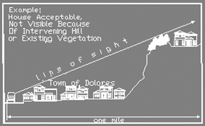
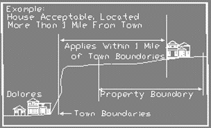
2.
However, if the only buildable site on a parcel is such that development on the parcel must be visible from centerline of Railroad or Central Avenues, development shall be sited and the height of structures shall be limited to so as to minimize visibility, as viewed from the centerline of Railroad Avenue or Central Avenue.
3.
This section shall not apply if the applicant produces adequate visual representation that a proposed new structure will not be visible as viewed from the centerline of Railroad or Central Avenues (e.g., artistic rendering or placement of balloons to illustrate top of structure).
Section 9.3. - Hillside development standards.
A.
Purposes.
The purposes of these standards are to:
1.
Require retention of natural landmarks and prominent natural features that enhance the character of the Town;
2.
Minimize the water runoff and soil erosion problems incurred in adjustment of hillside terrain to meet on-site and off-site development needs;
3.
Retain open hillsides and significant ridgelines in as near a natural state as is feasible as an important community value;
4.
Encourage the planning, design and development of hillside area building sites so as to provide maximum safety and human enjoyment;
5.
Encourage minimal grading which affects the natural contour of the land and which will round off, in a natural manner, sharp angles at the top and ends of cut-and-fill slopes;
6.
Require retention of trees and other vegetation which stabilize steep hillsides, retain moisture, minimize erosion and enhance the natural scenic beauty, and where necessary, require additional landscaping to enhance the scenic and safety qualities of the hillsides; and
7.
Provide for the preservation and maintenance of significant ridgelines, open space and recreational lands.
B.
Mandatory Conditions for the Creation of New Building Sites.
1.
No new lots shall be created with an average slope of thirty percent or more.
2.
No new lots shall be created with an average slope of the building envelope exceeding twenty-five percent unless a geologic hazard evaluation finds the site to be suitable for such construction.
C.
Mandatory Conditions for Existing Lots of Record.
1.
No structures or driveways shall be proposed on building pads with an average slope of thirty percent or more.
2.
Building sites with an average slope exceeding twenty-five percent shall have a geologic hazard evaluation prepared. The evaluation must find the site to be suitable for all construction proposed.
D.
Clustering of Dwelling Units.
Dwelling units may be clustered pursuant to the conservation subdivision regulations.
E.
Grading Standards.
Grading standards contained in this section shall apply to existing lots or building sites as well as to the creation of new building sites. All grading shall be in conformance with these standards. These standards are in addition to, and not in lieu of any requirements established by a geologic hazard evaluation.
1.
Grading shall be limited to the minimum necessary for development of roads, building sites, utilities and driveways. Portions of a site exceeding thirty percent slope shall not be graded without approval by a qualified engineer. Mass grading which would unreasonably affect the natural character of the area shall not be permitted.
2.
Visible cut or fill slopes shall not exceed three horizontal to one vertical (3:1); provided, however, that slopes as steep as two horizontal to one vertical (2:1) may be approved by a qualified engineer upon a finding that the appearance or stability of the completed project will be superior to the result that would be obtained by adhering to the three horizontal to one vertical (3:1) standard.
F.
Site Layout.
Each application for a site plan shall meet the following design standards:
1.
Avoid Unreasonable Interference with Views and Privacy.
The height, elevations, and placement on the site of the proposed main or accessory structure, when considered with reference to the nature and location of residential structures on adjacent lots, will avoid unreasonable interference with views and privacy.
2.
Preserve Natural Landscape.
The natural landscape will be preserved insofar as practicable by designing structures to follow the natural contours of the site and minimizing tree and soil removal; grade changes will be minimized and will be in keeping with the general appearance of neighboring developed areas.
3.
Minimize Perception of Excessive Bulk.
The proposed main or accessory structure in relation to the immediate neighborhood will minimize the perception of excessive bulk.
4.
Compatible Bulk and Height.
The proposed main or accessory structure will be compatible in terms of bulk and height with existing residential structures within the immediate neighborhood and within the same zoning district and shall not unreasonably impair the light and air of adjacent properties nor unreasonably impair the ability of adjacent properties to utilize solar energy.
5.
Current Grading and Erosion Control Standards.
The proposed site development or grading plan incorporates current grading and erosion control standards.
6.
Increased Setbacks and Height.
One foot shall be added to each side yard for each one foot of height above which the top plate line exceeds fifteen feet in height.
7.
Subfloors Clearance.
All new main structures and accessory structures or additions thereto, shall be designed to follow the slope of the site so as to reduce the clearance between ground floor levels and finish grade to not more than four feet. Five feet is permitted if a landscape and irrigation plan which will screen the subfloor area is submitted with the application for a building permit and landscaping is installed prior to final inspection of the structure.
8.
Design Standards.
a.
Where permitted, structures shall be integrated into the hillside or built at the base of the slope.
b.
Structures shall be located so that they are screened from view by their location and surrounding vegetation.
c.
Hillside structures shall not be the prominent or obvious focal point of the location.
d.
Wall and roof design, materials, and colors shall blend with the colors of the surrounding vegetation or rock outcroppings.
e.
Clearing of hillside vegetation shall be minimized to the smallest area possible, restricted to that necessary for the driveway, house, accessory structures, yard, and associated uses.
G.
Streets, Roads, and General Site Access to More Than Three Lots.
The standards in this section apply to development on slopes of 15 percent or greater.
1.
Access to a building or development site shall be by road, street, or private access road only.
2.
Streets, roads, private access roads, and other vehicular routes shall comply with all requirements of the Town of Dolores municipal code and design specifications.
3.
Streets, roads, private access roads, and other vehicular routes shall not be allowed to cross slopes between 30 and 50 percent unless specifically authorized by a qualified professional geologist or geotechnical engineer after finding that all of the following conditions and constraints are applicable:
a.
No alternate location for access is available;
b.
No individual segment or increment of the street, road, private access road, or other vehicular route that will cross slopes between 30 percent and 50 percent exceeds 100 feet in length;
c.
The cumulative length of individual segments or increments that will cross slopes between 30 percent and 50 percent does not exceed ten percent of the total length of the street, road, private access road, or other vehicular route; and
d.
No significant adverse visual, environmental, or safety impacts will result from the crossing, either by virtue of the design and construction of the street, road, private access road, or other vehicular route as originally proposed or as a result of incorporation of remedial improvements provided by the developer to mitigate such impacts.
4.
Under no circumstances shall any street, road, private access road, or other vehicular route cross slopes greater than 50 percent.
5.
Streets, roads, private access roads, and other vehicular routes shall, to the maximum extent feasible, follow natural contour lines.
6.
Grading for streets, roads, private access roads, and other vehicular routes shall be limited to the asphalt portion of the right-of-way, plus up to an additional 10 feet on either side of the asphalt as needed, except that when developing access on slopes in excess of 25 percent, only the asphalt portion of the right-of-way shall be graded plus the minimum area required for any necessary curb, gutter, or sidewalk improvements. The remainder of the access right-of-way shall be left undisturbed to the maximum extent feasible.
7.
Roads, other vehicular routes, or trails may be required to provide access or maintain existing access to adjacent lands for vehicles, pedestrians, emergency services, and essential service and maintenance equipment.
Section 9.4. - Grading and erosion control permit.
A.
Purpose.
The use of a grading and erosion control permit process allows the Town to understand and establish appropriate standards and criteria to mitigate, as needed, how development will actually affect the site, including terrain, drainage, or vegetation, immediately before construction is to take place, or minerals and material are to be removed. The purpose of this section is to protect the health, safety, and welfare of the citizens of Dolores by:
1.
Ensuring that the development of each site minimizes adverse impacts to adjacent properties by adequately addressing drainage, erosion, earth movement, and geologic hazards, and avoiding visually unpleasant grading designs or outcomes.
2.
Ensuring that the planning, design, and construction of a development will be done in a manner that provides maximum safety and human enjoyment, while making it as unobtrusive in the natural terrain as possible.
3.
Ensuring to the maximum extent practicable the permitting of reasonable development of land and minimizing fire hazard, the maximum retention of natural vegetation to aid in protection against erosion, earth movement, and other similar hazards and to aid in preservation of natural scenic qualities of the Town.
4.
Reducing air pollution caused by dust blown from areas under development.
5.
Preventing the premature cutting of roads and building sites in newly developing areas of the Town.
B.
Applicability.
1.
A grading and erosion control permit is required prior to any modification of the natural terrain that involves any of the following activities:
a.
An excavation, fill, or combination in excess of 100 cubic yards;
b.
An excavation which, at its greatest depth, will be 3 or more feet below the ground surface, over an area of 500 square feet or more;
c.
A fill that, at its greatest depth, will be 3 or more feet above the ground surface, over an area of 500 square feet or more;
d.
An excavation or fill by a developer or contractor not working on behalf of the Town or a Public Utility that falls within a public sewer, water main, storm drainage, or power line easement, a public right-of-way, or any other public utility easement. This includes the preparation of roads, sidewalk, etc. (major grading);
e.
Vegetation removal over an area 500 square feet or more (major grading); or
f.
Mining, quarrying, or gravel operations.
2.
The following activities are exempt from the grading permit requirement:
a.
Solid waste disposal sites operated by the public or under public regulations;
b.
An excavation by the Town for the purpose of maintenance or installation of public utilities, buildings, streets, or easements;
c.
An excavation by a private individual for the purpose of routine maintenance; and
d.
Tilling the ground for agricultural purposes or protection.
C.
Permit Application.
See Section 13.12, Grading and Erosion Control Permit.
D.
Erosion and Air Pollution Control.
1.
At the completion of construction, all cut and fill surfaces created by grading and subject to erosion, except those created by plowing or discing for agricultural or fire break purposes, shall be planted with native or naturalized materials appropriate to Southwestern Colorado that require minimum water use, as identified by any of the following guides or sources:
a.
Colorado State University Extension Service,
b.
City of Durango Tree & Shrub Guide,
c.
Dolores and Mancos Conservation District, or
d.
Waterwise resources for the San Juan Basin or as identified by the Denver Botanic Gardens.
2.
Topsoils shall be stockpiled during rough grading and used on cut and fill slopes.
3.
On slopes likely to be extensively disturbed by later construction, an interim ground cover may be planted to be supplemented by the permanent ground cover and/or shrubs and trees when the site is finally developed and landscaped.
4.
When slopes too steep to support continuous ground cover have been permitted and in lieu thereof niches and ledges provided for planting, such slopes need not be planted with a continuous ground cover but may instead be screened with vines and plantings. The Town may require retaining walls on steep slopes unless the stability of a cut on such slope is certified by a licensed engineer.
5.
Cuts and fills along public roads may be required to be landscaped so as to blend into the natural surroundings.
6.
Efforts shall be made to abate the dust caused by the development of sites. Methods such as watering, erosion controls, or chemical treatment shall be specified in the grading permit approval for the purpose of abating dust.
Section 9.5. - Flood hazard regulations.
A.
Authorization.
1.
Statutory Authorization.
The Legislature of the State of Colorado has delegated the responsibility of local governmental units to adopt regulations designed to minimize flood losses.
2.
Findings of Fact.
a.
The floor hazard areas of Dolores are subject to periodic inundation which results in loss of life and property, health and safety hazards, disruption of commerce and governmental services, and extraordinary public expenditures for flood protection and relief, all of which adversely affect the public health, safety and general welfare.
b.
These flood losses are created by the cumulative effect of obstructions in floodplains which cause an increase in flood heights and velocities, and by the occupancy of flood hazards areas by uses vulnerable to floods and hazardous to other lands because they are inadequately elevated, flood-proofed or otherwise protected from flood damage.
3.
Statement of Purpose.
It is the purpose of this ordinance to promote the public health, safety and general welfare and to minimize public and private losses due to flood conditions in specific areas by provisions designed to:
a.
Protect human life and health;
b.
Minimize expenditure of public money for costly flood control projects;
c.
Minimize the need for rescue and relief efforts associated with flooding and generally undertaken at the expense of the general public;
d.
Minimize prolonged business interruptions;
e.
Minimize damage to public facilities and utilities such as water and gas mains, electric, telephone and sewer lines, streets and bridges located in floodplains; and
f.
Help maintain a stable tax base by providing for the sound use and development of flood-prone areas in such a manner as to minimize future flood blight areas; and
4.
Methods of Reducing Flood Losses.
In order to accomplish its purposes, this ordinance uses the following methods:
a.
Restrict or prohibit uses that are dangerous to health, safety or property in times of flood, or cause excessive increases in flood heights or velocities;
b.
Require that uses vulnerable to floods, including facilities which serve such uses, be protected against floor damage at the time of initial construction;
c.
Control the alteration of natural floodplains, stream channels, and natural protective barriers, which are involved in the accommodation of flood waters;
d.
Control filling, grading, dredging and other development which may increase flood damage;
e.
Prevent or regulate the construction of flood barriers which will unnaturally divert flood waters or which may increase flood hazards to other lands.
B.
Definitions.
See Section 2.6, Flood Hazard Definitions.
C.
General Provisions.
1.
Lands to Which this Section Applies.
The section shall apply to all areas of special flood hazard within the jurisdiction of the Town of Dolores.
2.
Basis for Establishing the Areas of Special Flood Hazard.
The areas of special floor hazard identified by the Federal Emergency Management Agency in a scientific and engineering report entitled, "The Flood Insurance Study for the Town of Dolores," dated September 1987, with accompanying Flood Insurance Rate Maps and Flood Boundary-Floodway Maps (FIRM and FBRM) and any revisions thereto are hereby adopted by reference and declared to be a part of this ordinance.
3.
Establishment of Floodplain Development Permit.
A Floodplain Development Permit shall be required to ensure conformance with the provisions of this ordinance.
4.
Compliance.
No structure or land shall hereafter be located, altered, or have its use changed without full compliance with the terms of this ordinance and other applicable regulations.
5.
Abrogation and Greater Restrictions.
This section is not intended to repeal, abrogate, or impair any existing easements, covenants, or deed restrictions. However, where this section and another ordinance, easement, covenant, or deed restrictions conflict or overlap, whichever imposes the more stringent restrictions shall prevail.
6.
Interpretation.
In the interpretation and application of this ordinance, all provisions shall be:
a.
Considered as minimum requirements;
b.
Liberally construed in favor of the governing body; and
c.
Deemed neither to limit nor repeal any other powers granted under State statutes.
7.
Warning and Disclaimer of Liability.
The degree of flood protection required by this section is considered reasonable for regulatory purposes and is based on scientific and engineering considerations. On rare occasions greater floods can and will occur and flood heights may be increased by man-made or natural causes. This section does not imply that land outside the areas of special flood hazards or uses permitted within such areas will be free from flooding or flood damages. This section shall not create liability on the part of the community or any official or employee thereof for any flood damages that result from reliance on this section or any administrative decision lawfully made thereunder.
D.
Administration.
1.
Designation of the Floodplain Administrator.
The Town Administrator is hereby appointed the Floodplain Administrator to administer and implement the provisions of this ordinance and other appropriate sections of 44 CFR (National Flood Insurance Program Regulations) pertaining to floodplain management. The Town Administrator may delegate this responsibility to a Town staff representative or qualified consultant hired by the Town.
2.
Duties and Responsibilities of the Floodplain Administrator.
Duties and responsibilities of the Floodplain Administrator shall include, but not be limited to, the following:
a.
Maintain and hold open for public inspection all records pertaining to the provisions of this ordinance.
b.
Review permit application to determine whether proposed building site, including the placement of manufactured homes, will be reasonably safe from flooding.
c.
Review, approve or deny all applications for development permits required by adoption of this ordinance.
d.
Review permits for proposed development to assure that all necessary permits have been obtained from those Federal, State, or local governmental agencies (including Section 404 of the Federal Water Pollution Control Act Amendments of 1972, 33 U.S.C. 1334) from which prior approval is required.
e.
Where interpretation is needed as to the exact location of the boundaries of the areas of special flood hazards (for example, where there appears to be a conflict between a mapped boundary and actual field conditions) the Floodplain Administrator shall make the necessary interpretation.
f.
Notify, in riverine situations, adjacent communities and the State Coordinating Agency prior to any alteration or relocation of a watercourse and submit evidence of such notification to the Federal Emergency Management Agency.
g.
Assure that the flood carrying capacity within the altered or relocated portion of any watercourse is maintained.
h.
When base flood evaluation data has not been provided in accordance with these regulations, the Floodplain Administrator shall obtain, review and reasonably utilize any base flood evaluation data and floodway data available from a Federal, State or other source, as needed to administer these standards.
i.
When a regulatory floodway has not been designated, the Floodplain Administrator must require that no new construction, substantial improvements, or other development (including fill) shall be permitted within Zones A1-30 and AE on the community's FIRM, unless it is demonstrated that the cumulative effect of the proposed development, when combined with all other existing and anticipated development, will not increase the water surface elevation of the base flood more than one foot at any point within the community.
j.
Under the provisions of 44 CFR Chapter 1, Section 692, of the National Flood Insurance Program regulations, a community may approve certain development in Zones A1-30, AE, AH, on the community's FIRM which increases the water surface elevation of other base flood by more than one foot, provided that the community first applies for a condition FIRM revision through FEMA (Conditional Letter of Map Revision).
3.
Permit Procedures.
a.
Application for a Development Permit shall be presented to the Floodplain Administrator on forms furnished by him/her and may include, but not be limited to, plans in duplicate drawn to scale showing the location, dimensions, and elevation of proposed landscape alterations, existing and proposed structures, including the placement of manufactured homes, and the location of the foregoing in relation to areas of special flood hazard. Additionally, the following information is required:
(1)
Elevation (in relation to mean sea level), of the lowest floor (including basement) of all new and substantially improved structures;
(2)
Elevation in relation to mean sea level to which any nonresidential structure shall be floodproofed;
(3)
A certificate from a registered professional engineer or architect that the nonresidential floodproofed structure shall meet the floodproofing criteria of Section E.2.a;
(4)
Description of the extent to which any watercourse or natural drainage will be altered or relocated as a result of proposed development.
(5)
Maintain a record of all such information in accordance with Section D.2.a.
b.
Approval or denial of a Development Permit by the Floodplain Administrator shall be based on all of the provisions of this ordinance and the following relevant factors:
(1)
The danger to life and property due to flooding or erosion damage;
(2)
The susceptibility of the proposed facility and its contents to flood damage and the effect of such damage on the individual owner;
(3)
The danger that materials may be swept onto other lands to the injury of others;
(4)
The compatibility of the proposed use with existing and anticipated development;
(5)
The safety of access to the property in times of flood for ordinary and emergency vehicles;
(6)
The costs of providing government services during and after flood conditions including maintenance and repair of streets and bridges, and public utilities and facilities such as sewer, gas, electrical and water systems;
(7)
The expected heights, velocity, duration, rate of rise and sediment transport of the flood waters and the effects of wave action, if applicable, expected at the site;
(8)
The necessity to the facility of waterfront location, where applicable;
(9)
The availability of alternative locations, not subject to flooding or erosion damage, for the proposed use;
(10)
The relationship of the proposed use to the comprehensive plan for that area.
4.
Variance Procedures.
a.
The Appeal Board as established by the community shall hear and render judgment on requests for variances from the requirements of this ordinance.
b.
The Appeal Board shall hear and render judgment on an appeal only when it is alleged there is an error in any requirement, decision, or determination made by the Floodplain Administrator in the enforcement or administration of this ordinance.
c.
Any person or persons aggrieved by the decision of the Appeal Board may appeal such decision in the courts of competent jurisdiction.
d.
The Floodplain Administrator shall maintain a record of all actions involving an appeal and shall report variances to the Federal Emergency Management Agency upon request.
e.
Variances may be issued for the reconstruction, rehabilitation or restoration of structures listed on the National Register of Historic Places or the State Inventory of Historic Places, without regard to the procedures set forth in the remainder of this ordinance.
f.
Variances may be issued for new construction and substantial improvements to be erected on a lot of one-half acre or less in size contiguous to and surrounded by lots with existing structures constructed below the base flood level, providing the relevant factors in Section D.3.b have been fully considered. As the lot size increases beyond the one-half acre, the technical justification required for issuing the variance increases.
g.
Upon consideration of the factors noted above and the intent of this Code, the Appeal Board may attach such conditions to the granting of variances as it deems necessary to further the purpose and objectives of this section.
h.
Variances shall not be issued within any designated floodway if any increase in flood levels during the base flood discharge would result.
i.
Variances may be issued for the repair or rehabilitation of historic structures upon a determination that the proposed repair or rehabilitation will not preclude the structure's continued designation as a historic structure and the variance is the minimum necessary to preserve the historic character and design of the structure.
j.
Prerequisites for granting variances:
(1)
Variances shall only be issued upon a determination that the variance is the minimum necessary, considering the flood hazard, to afford relief.
(2)
Variances shall only be issued upon:
(a)
showing a good and sufficient cause;
(b)
a determination that failure to grant the variance would result in exceptional hardship to the applicant, and
(c)
a determination that the granting of a variance will not result in increased flood heights, additional threats to public safety, extraordinary public expense, create nuisances, cause fraud on or victimization of the public, or conflict with existing local laws or ordinances.
k.
Any application to whom a variance is granted shall be given written notice that the structure will be permitted to be built with the lowest floor elevation below the base flood elevation, and that the cost of flood insurance will be commensurate with the increased risk resulting from the reduced lowest floor evaluation.
2.
Variances may be issued by a community for new construction and substantial improvements and for other development necessary for the conduct of a functionally dependent use provided that:
a.
The criteria outlined in Section D.3.b are met, and
b.
The structure or other development is protected by methods that minimize flood damages during the base flood and create no additional threats to public safety.
E.
Provisions for Flood Hazard Reduction.
1.
General Standards.
In all areas of special flood hazards the following provisions are required for all new construction and substantial improvements:
a.
All new construction or substantial improvements shall be designed (or modified) and adequately anchored to prevent flotation, collapse or lateral movement of the structure resulting from hydrodynamic and hydrostatic loads, including the effects of buoyancy;
b.
All new construction or substantial improvements shall be constructed by methods and practices that minimize flood damage;
c.
All new construction or substantial improvements shall be constructed with materials resistant to flood damage;
d.
All new construction or substantial improvements shall be constructed with electrical, heating, ventilation, plumbing, and air conditioning equipment and other service facilities that are designed and/or located so as to prevent water from entering or accumulating within the components during conditions of flooding.
e.
All new and replacement water supply systems shall be designed to minimize or eliminate infiltration of flood waters into the system;
f.
New and replacement sanitary sewage systems shall be designed to minimize or eliminate infiltration of flood waters into the system and discharge from the systems into flood waters; and,
g.
On-site waste disposal systems shall be located to avoid impairment to them or contamination from them during flooding.
h.
When a regulatory floodway has not been designated, the Floodplain Administrator must require that no new construction, substantial improvements, or other development (including fill) shall be permitted within Zones A1-30 and AE on the community's FIRM, unless it is demonstrated that the cumulative effect of the proposed development, when combined with all other existing and anticipated development, will not increase the water surface elevation of the base flood more than one foot at any point within the community; and,
i.
Under the provisions of 44 CFR Chapter 1, Section 692, of the National Flood Insurance Program regulations, a community may approve certain development in Zones A1-30, AE, AH, on the community's FIRM which increases the water surface elevation of the base flood by more than one foot, provided that the community first applies for a conditional FIRM revision through FEMA (Conditional Letter of Map Revision).
2.
Specific Standards.
In all areas of special flood hazards where based flood elevation data has been provided as set forth in (i)Section 9.5.C.2, (ii) Section 9.5.D.2.h., or (iii)Section 9.5.E.5.c, the following provisions are required:
a.
Residential Construction - new construction and substantial improvement on any residential structure shall have the lowest floor (including basement), elevated to or above the base flood elevation. A registered professional engineer, architect, or land surveyor shall submit a certification to the Floodplain Administrator that the standard of this subsection as proposed in Article 54, Section C(1) a., is satisfied.
b.
Crawlspace Amendment.
Below-Grade Residential Crawlspace Construction: New construction and substantial improvement of any below-grade crawlspace shall:
(1)
Have the interior grade elevation that is below base flood elevation no lower than two feet below the lowest adjacent grade;
(2)
Have the height of the below-grade crawlspace measured from the interior grade of the crawlspace to the top of the foundation wall, not exceed four feet at any point;
(3)
Have an adequate drainage system that allows floodwaters to drain from the interior area of the crawlspace following a flood;
(4)
Be anchored to prevent flotation, collapse, or lateral movement of the structure and be capable of resisting the hydrostatic and hydrodynamic loads;
(5)
Be constructed with materials and utility equipment resistant to flood damage;
(6)
Be constructed using methods and practices that minimize flood damage;
(7)
Be constructed with electrical, heating, ventilation, plumbing, and air conditioning equipment and other service facilities that area designed and/or located so as to prevent water from entering or accumulating within the components during conditions of flooding;
(8)
Be designed to automatically equalize hydrostatic flood forces on exterior walls by allowing for the entry and exit of floodwaters. Designs for meeting this requirement must either be certified by a registered professional engineer or architect or must meet or exceed the following minimum criteria:
(a)
A minimum of two openings having a total net area of not less than one square inch for every square foot of enclosed area subject to flooding shall be provided;
(b)
The bottom of all openings shall be no higher than one foot above grade;
(c)
Openings may be equipped with screens, louvers, or other coverings or devices provided that they permit the automatic entry and exist of floodwaters.
c.
Nonresidential Construction - new construction and substantial improvements of any commercial, industrial or other nonresidential structure shall either have the lowest floor (including basement) elevated to or above the base flood level or together with attendant utility and sanitary facilities, be designed so that below the base flood level the structure is watertight with walls substantially impermeable to the passage of water and with structural components having the capability of resisting hydrostatic and hydrodynamic loads and effects of buoyancy. A registered professional engineer or architect shall develop and/or review structural design, specifications, and plans for construction, and shall certify that the design and methods of construction are in accordance with accepted standards of practice as outlined in this subsection. A record of such certification which included the specific elevation (in relation to mean sea level) to which such structures are floodproofed shall be maintained by the Floodplain Administrator.
2.
Enclosures - new construction and substantial improvements, with fully enclosed areas below the lowest floor that are usable solely for parking of vehicles, building access or storage in an area other than a basement and which are subject to flooding shall be designed to automatically equalize hydrostatic flood forces on exterior walls by allowing for the entry and exit of floodwaters. Designs for meeting this requirement must either be certified by a registered professional engineer or architect or meet or exceed the following minimum criteria:
a.
A minimum of two openings having a total net area of not less than one square inch for every square foot of enclosed area subject to flooding shall be provided.
b.
The bottom of all openings shall be no higher than one foot above grade.
c.
Openings may be equipped with screens, louvers, valves, or other coverings or devices provided that they permit the automatic entry and exit of floodwaters.
3.
Manufactured Homes.
a.
Require that all manufactured homes to be placed within Zone A on a community's FHBM or FIRM shall be installed using methods and practices which minimize flood damage. For the purposes of this requirement, manufactured homes must be elevated and anchored to resist flotation, collapse, or lateral movement. Methods of anchoring may include, but are not limited to, use of over-the-top or frame ties to ground anchors. This requirement is in addition to applicable State and local anchoring requirements for resisting wind forces.
b.
Require that manufactured homes that are placed or substantially improved within Zones A1-30, AH, and AE on the community's FIRM on sites (i) outside of a manufactured home park or subdivision, (ii) in a new manufactured home park or subdivision, (iii) in an expansion to an existing manufactured home park or subdivision, or (iv) in an existing manufactured home park or subdivision on which a manufactured home has incurred "substantial damage" as a result of a flood, be elevated on a permanent foundation such that the lowest floor of the manufactured home is elevated to or above the base flood elevation and be securely anchored to an adequately anchored foundation system to resist flotation, collapse, and lateral movement.
c.
Require that manufactured homes be placed or substantially improved on sites in an existing manufactured home park or subdivision with Zones A1-30, AH and AE on the community's FIRM that are not subject to the provisions of E.3.a and E.3.b of this section be elevated so that either:
(1)
the lowest floor of the manufactured home is at or above the base flood elevation, or
(2)
the manufactured home chassis is supported by reinforced piers or other foundation elements of at least equivalent strength that are no less than 36 inches in height above grade and be securely anchored to an adequately anchored foundation system to resist flotation, collapse, and lateral movement.
4.
Recreational Vehicles.
a.
Require that recreational vehicles placed on sites within Zones A1-30, AH, and AE on the community's FIRM either:
(1)
be on the site for fewer than 180 consecutive days,
(2)
be fully licensed and ready for highway use, or
(3)
meet the permit requirements of Section 9.5.D.3.a, and the elevation and anchoring requirements for "manufactured homes" in subsection 3.a of this section. A recreational vehicle is ready for highway use if it is on its wheels or jacking system, is attached to the site only by quick disconnect type utilities and security devices, and has no permanently attached additions.
5.
Standards for Subdivision Proposals.
a.
All subdivision proposals including the placement of manufactured home parks and subdivisions shall be consistent with Section 9.5.A.2 to 4.
b.
All proposals for the development of subdivisions including the placement of manufactured home parks and subdivisions shall meet the Section 9.5.C.3 Development Permit requirement.
c.
Base flood elevation data shall be generated for subdivision proposals and other proposed development including the placement of manufactured home parks and subdivisions which is greater than 50 lots or 5 acres, whichever is lesser, if not otherwise provided pursuant to Section 9.5.C.2 or Section 9.5.D.2.h.
d.
All subdivision proposals including the placement of manufactured home parks and subdivisions shall have adequate drainage provided to reduce exposure to flood hazards.
e.
All subdivision proposals including the placement of manufactured home parks and subdivisions shall have public utilities and facilities such as sewer, gas, electrical and water systems located and constructed to minimize or eliminate flood damage.
6.
Standards for Areas of Shallow Flooding (AO/AH Zones).
Located within the areas of special flood hazard established in Section 9.5.C.2, are areas designated as shallow flooding. These areas have special flood hazards associated with base flood depths of 1 to 3 feet where a clearly defined channel does not exist and where the path of flooding is unpredictable and where velocity flow may be evident. Such flooding is characterized by ponding or sheet flow; therefore, the following provisions apply:
a.
All new construction and substantial improvements of residential structures have the lowest floor elevated above the highest adjacent grade at least as high as the depth number specified in feet on the community's FIRM (at least two feet if no depth number is specified).
b.
All new construction and substantial improvements of non-residential structures;
(1)
have the lowest floor (including basement) elevated above the highest adjacent grade at least as high as the depth number specified in feet on the community's FIRM (at least two feet if no depth number is specified), or;
(2)
together with attendant utility and sanitary facilities be designed so that below the base flood level the structure is watertight with walls substantially impermeable to the passage of water and with structural components having the capability of resisting hydrostatic and hydrodynamic loads of effects of buoyancy.
c.
A registered professional engineer or architect shall submit a certification to the Floodplain Administrator that the standards of this Section, as proposed in, Section 9.5.D.3.a., are satisfied.
d.
Require within Zones AH or AO adequate drainage paths around structures on slopes, to guide flood waters around and away from proposed structures.
Section 9.6. - Riparian buffer standards.
A.
Purpose.
This section is intended to establish buffers that minimize erosion, stabilize stream banks, protect and improve water quality, preserve fish and wildlife habitat, and preserve the natural aesthetic value of riparian areas, defined as the interface zone between land and a stream or river.
B.
Buffers Established.
1.
The following buffers are established by the mapped floodplain area, or from the mean annual high water line (AHWL), as determined by a qualified professional geologist or geotechnical engineer, on each side of any perennial stream or river, water body, or wetland.
2.
Classifications of surface waters as perennial or intermittent streams, or as a lake or pond, shall be as indicated on the most recent version of the United States Geological Survey (USGS) 1:24,000 (7.5 minute) scale topographic maps, or the most recent version of the soil survey map prepared by the Natural Resources Conservation Service of the United States Department of Agriculture (USDA). If there exists a discrepancy between these maps that would affect a required buffer, the classification requiring the most stringent buffer shall be applied.
C.
Applicability.
1.
This subsection shall apply to all new development, except for the following development or activities:
a.
Agricultural activities, such as soil preparation, irrigation, grazing, planting, and harvesting;
b.
Maintenance and repair of existing public roads, utilities, and other public facilities within an existing right-of-way or easement;
c.
Maintenance and repair of flood control structures and activities in response to a flood emergency; and
d.
Wetland and wildlife habitat restoration, construction, or enhancement that improves or restores the wetland or stream corridor functions, provided that the proposed activity is approved by the appropriate agency such as the U.S. Army Corps of Engineers.
2.
Up to 50 percent of the Outer Zone setback may be waived for development on a lot that was created prior to 2021.
3.
The standards of this section shall apply in addition to the standards of Section 9.5, Flood Hazard Regulations. In the event that there is any conflict between the two, the more restrictive provision shall apply.
D.
Riparian Protection Buffer.
1.
Intent.
The riparian protection buffer is intended to protect the habitat, wetland, slopes, stream integrity, and features in the immediate vicinity of riparian areas. These areas are typically ecologically rich but sensitive habitats that also serve as critical buffers to sedimentation.
2.
Minimum Total Width.
The minimum total width of the riparian protection buffer shall be the width of the mapped floodplain, or where the floodplain is not mapped or is narrower than 50 feet, 50 feet from the AHWL on both sides. On residential properties, the minimum width of the riparian protection buffer may be reduced to 25 feet in some locations where the floodplain in that area is less than 25 feet wide, and if an average setback of 50 hundred feet is maintained across the property as a whole.
3.
Riparian Protection Buffer Zones.
The riparian protection buffer area shall be divided into two zones as described below:
a.
Streamside Zone - Zone 1
(1)
Zone 1 shall begin at each edge of any identified riparian area, and shall occupy a margin of land on each side, each with a minimum width of 25 feet from any wetland, water body, or any perennial stream. Where very steep slopes (30 percent or greater) are located within, and extend beyond such margin, Zone 1 shall extend to include the entirety of the very steep slopes up to a maximum dimension of 50 feet.
(2)
No disturbance of land shall be allowed within Zone 1 including, but not limited to, dumping, filling, dredging, new construction, excavating, substantial improvements or modifications, scraping by motorized equipment, removal of native vegetation or root systems, or transferring materials that will reduce the natural storage capacity of the land, interfere with the natural flow pattern of any watercourse, or degrade the quality of surface or ground water. Limited exceptions to these restrictions include:
(a)
Flood control structures;
(b)
Stream restoration practices;
(c)
Selected removal of dead, hazardous, or invasive vegetation or vegetation management in accordance with an approved landscape plan;
(d)
Utility rights-of-way and construction;
(e)
Unpaved pedestrian trails; and
(f)
Roads where no economically feasible alternative exists.
b.
Outer Buffer Zone- Zone 2
(1)
Zone 2 provides for limited uses in a buffer between development and Zone 1. It also provides separation between areas of intense human use and riparian features associated with intermittent or ephemeral streams.
(2)
The minimum width of Zone 2 for wetlands, waterbodies, and perennial streams shall be from the edge of Zone 1 to the limit of the mapped floodplain. The width of Zone 2 when applied to intermittent streams is 50 feet.
(3)
No significant disturbance of land shall be allowed within Zone 2 buffers including, but not limited to, dumping, filling, dredging, new construction , excavating, substantial improvements or modifications, scraping by motorized equipment, removal of native vegetation or root systems, or transferring materials that will reduce the natural storage capacity of the land or interfere with the natural flow pattern of any watercourse or degrade the quality of surface or ground water. The following structures, uses, and activities are permitted in the riparian transition buffer:
(a)
Any use permitted in the Zone 1 buffer,
(b)
Non-agricultural open fencing,
(c)
Biking or hiking trails;
(d)
Stormwater management facilities with the approval of a qualified engineer;
(e)
Recreation uses with the approval of the Floodplain Administrator; and
(f)
Reconstruction of existing structures is permitted in accordance with this Code.
Section 9.7. - Wildfire hazard study.
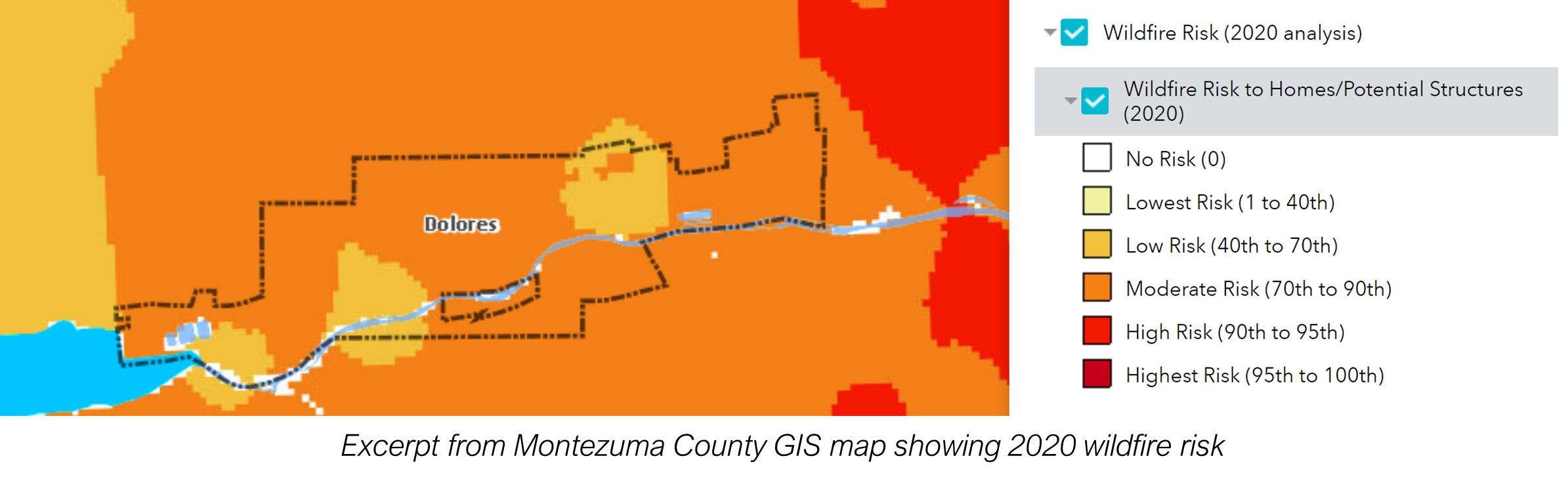
Excerpt from Montezuma County GIS map showing 2020 wildfire risk
A.
Purpose.
A wildfire hazard study is required to demonstrate how new major development will reduce or minimize the potential impacts of wildfire hazards on properties, the occupants of properties, and the occupants of adjacent properties and facilitate access to manmade structures by firefighters in the event of a wildfire. A wildfire hazards study shall be accepted by the Town only when prepared by a natural resource professional with expertise in the field of vegetation management and wildfire mitigation.
B.
Applicability.
1.
Applicants that propose any of the following developments in moderate, high, or highest wildfire hazard areas, as designated on the on the Montezuma County Wildfire Hazard Map, shall prepare a wildfire hazard study that is submitted in conjunction with the first project development application (e.g., rezoning, subdivision, site plan).
a.
Multifamily including multiple two-unit structures, mixed-use, or nonresidential development on new or existing lots,
b.
New subdivisions or resubdivision that creates new lots, or
c.
Planned unit developments.
2.
Applicants for single- or two-unit development are not required to prepare a wildfire hazard study but are required to comply with the Colorado State University FireWise plant materials list.
C.
Concept Review.
1.
Applicants who are required to submit a wildfire hazard study may request a concept review with the Zoning Administrator to determine the geographic scope of the study.
2.
The applicant shall submit an initial wildfire hazard study that provides an initial site-specific evaluation, including, at a minimum:
a.
A copy of the relevant portion of the Montezuma County Wildfire Hazard Map overlaid with the location of proposed structures and the boundaries of the property on which development is proposed; and
b.
A statement of objectives for the vegetation and wildfire management plan.
D.
Wildfire Hazard Study.
The study shall provide a detailed, site specific analysis that includes the following minimum information:
1.
A schedule delineating how the wildfire mitigation actions identified in the study will be implemented including, but not limited to, vegetation thinning, creation of fuel breaks, and the installation of working fire hydrants, fire cisterns, or dry hydrants prior to the introduction of combustible construction materials on the site;
2.
Communication capabilities during construction with the ERFPD and the type of communication system. A physical address is required for E-911 purposes;
3.
Detailed specification of fire protection equipment and emergency preparedness actions to be installed or implemented and maintained within the subdivision during construction;
4.
Detailed mitigation actions including, but not limited to, thinning, spacing, and removal of trees and vegetation and building construction techniques designed to mitigate wildfire hazard areas.
5.
The identification of building envelopes shall be required to locate structures outside of severe hazard areas, off of steep slopes, and outside of ravines and canyons to the maximum extent feasible;
6.
Identification of the entities responsible for implementing the plan, constructing required improvements, and maintenance in perpetuity of the improvements and appropriate easements, if any;
7.
A map identifying major timber stands and vegetation, locations of fire hydrants, water tanks, cisterns or dry hydrants, as well as locations and flows or capacity of fire hydrants, water tanks, cisterns, or dry hydrants.
E.
Referral to Colorado State Forest Service.
1.
As part of the review of the wildfire hazard study, the Zoning Administrator shall refer the development application to the Colorado State Forest Service (CSFS). Referral of final plat applications will be at the discretion of the Zoning Administrator.
2.
CSFS shall review the application and comment on the potential effectiveness of the management plan and the mitigation techniques proposed and make recommendations based on guidelines promulgated by CSFS. (See, for example, "Creating Wildfire-Defensible Zones, No. 6.302 or currently accepted standards.)
3.
The Town shall consider the recommendations of the CSFS and apply the appropriate recommendations as conditions of approval of the development application.
F.
Requirements for Final Approvals.
Based on Town and CSFS review, the applicant may be required to revise the study. The applicant must demonstrate prior to development approval how the development complies with the mitigation strategies identified in the study.