
Escalante City Zoning Code
10.54 Subdivisions
10.54.010 Purpose
The provisions of this chapter are enacted for the purpose of adopting subdivision regulations for the divisions of lands within the City. This Chapter applies to all applications or petitions to subdivide land in the City. The regulations, actions, data, exceptions, suggestions and conditions set forth in this title are designated to assist the subdivider in the preparation of his plans and shall apply to all subdivisions of property wholly within the City limits.
(Ord. 1987-1 sec. 1-1. 1987)
10.54.020 Application
The provisions of this chapter shall be applicable to all subdivisions within the city. It is unlawful for any person to offer or lease, to contract to sell or lease, or to sell or lease any such subdivision, or any part thereof, which is located in the City until an approved subdivision application in full compliance with the provisions of this Chapter, shall have been duly recorded or filed in the office of the Garfield County recorder.
(Ord. 1987-1 sec. 1-2. 1987)
10.54.030 Definitions - Subdivisions
Unless the context requires otherwise, the following definitions shall be used in the interpretation and construction of this Ordinance. Words used in the present tense include the future; singular numbers shall include the plural, and the plural, the singular; the word "building" shall include the word "structure"; and the words "used" and "occupied" shall include arranged, designed, constructed, altered, converted, rented, leased or intended to be used or occupied; the word "shall" is mandatory and not directory, and the word "may" is permissive; the word "person" includes firm, association, organization, partnership, trust, company, or corporation, as well as an individual; the word "lot" includes the words plot or parcel. Words used in this Ordinance but not defined herein shall have the meaning as defined in any other Ordinance adopted by the Escalante City Council:
BEGINNING OF CONSTRUCTION: Grading or removal of any vegetation or earth from a site for construction of access routes or preparation for excavation of building pads or footings.
BUILDING: Any structure used or intended to be used for the shelter or enclosure of a person, animals or property.
BUILDING, HEIGHT OF: The vertical distance from the average finished grade surface to the highest point of the building roof or coping.
BUILDING SET BACK LINE: A line parallel to the street line between which no building structure or portion thereof, may be erected, constructed or established.
BUILDING OFFICIAL: The official designated as the Building Inspector for Escalante City.
CAMPGROUND: A parcel designated and approved by Escalante City for occupancy by tents, trailers, motor homes or campers on a temporary basis.
CITY ENGINEER: The Escalante City Engineer or his duly authorized representative. (Ord. 1987 sec 1-3, 1987)
COMMISSION: Means the planning commission of the City, provided however, that the city board may act for and in the place of the planning commission, as set forth in Chapter/Section 24/111.
COMMISSION'S AUTHORIZED REPRESENTATIVE: Means the planning director or any other city employee or official who has been designated by the commission to represent the city enforcing or carrying out the function of the commission as set forth in this chapter.
COUNTY: County shall mean Garfield County, Utah.
CUL-DE-SAC: A street or passage that is only open on one end, which must measure 100 feet in radius at its termination.
DESIGN: Design refers to a street alignment, grades and widths, and alignment and widths of easements and right-of-way for roads, drainage, sewage, water supply and other utilities, lot area dimensions, and the treatment of such factors for the proposed use of the land.
DIVISION OF AGRICULTURE LAND FOR AGRICULTURE PURPOSES: A bona fide division or partition of agriculture land into two (2) or more parcels for agriculture purposes as defined herein.
DWELLING: Any building or portion thereof, which is designed for residential use, except the following: hotels, apartment hotels, boarding houses, lodging houses, motels, apartment motels, trailers, mobile homes, or dormitories.
DWELLING. SINGLE FAMILY: A building arranged or designed to be occupied by one (1) family, the structure having only one (1) dwelling unit.
DWELLING. MULTIPLE FAMILY: A building arranged or designed to be occupied by more than one (1) family.
EASEMENT: The acquired privilege or right-of-use or enjoyment that one person may have on the land of another.
ENGINEER: Means the engineer or a surveyor engaged by the subdivider to prepare a final map or to compile such data as may be required in connection therewith in accordance with the provisions of this chapter. Such engineer shall be a registered civil engineer in the State of Utah.
ESSENTIAL SERVICES: Utilities or sanitary and public safety facilities provided by a public or other governmental agency for overhead or surface or underground services, excluding any building, electrical substation and transmission lines.
FAMILY: An individual, or two (2) or more persons related by blood, marriage, or adoption, or a group of not more than four (4) persons ( who are not related, living in a dwelling unit as a single housekeeping unit and using common cooking facilities.
FENCE: A physical barrier to delineate, contain, or designate an area designed for a specific use i.e., an enclosure for dwelling unit; an area for storage, etc.
FLOOD PLAIN: A highest area of land subject to inundation or overflow water having sufficient velocity to transport or deposit debris, scour the surface soil, dislodge or damage buildings, or erode the banks of water courses within a hundred (100) year time frame.
FRONTAGE BLOCK: All property fronting on one (1) side of the street between intersecting streets or between a street and a right-of-way, waterway, end of dead end street, or political subdivision boundaries, measured along the street line. An intersecting street shall determine only the boundary of the frontage on the side of the street which it intersects.
GEOLOGICAL HAZARD: A hazard inherent in the crust of the earth, or artificially created, which is dangerous or potentially dangerous to life, property, or improvements, due to the movement, failure or shifting of the earth.
GRADE: For buildings adjoining one (1) street, the elevation of the sidewalk at the center of the wall adjoining the street. For buildings adjoining more than one (1) street, the average of the elevation of the sidewalk at the center of all walls adjoining the streets.
HIS: Refers to male or female gender.
IMPROVEMENT PLAN: A plan to complete permanent infrastructure on the subdivision that is essential for the public health and safety, that is required for human occupation, or that is required by applicable law and that an applicant must install in accordance with public installation and inspection specifications for public improvements and as a condition of recording a subdivision plat.
IRRIGATED LAND: Parcels that have surface or underground water diverted continuously or intermittently upon them for the production of crops or pasture, through the utilization of man-made improvements.
LANE: A street, either one-way or two-way, with a width less than fifty (50) feet.
LAND USE AUTHORITY: An individual, board, or commission appointed or employed by a municipality to make land use decisions. “Land Use Authority” includes any appropriately authorized designees.
LAND USE APPLICATION: An application required by the City and submitted by a land use applicant to obtain a land use approval; this does not mean an application to enact, amend, or repeal a land use regulation.
LOT: A parcel or unit of land described by metes and bounds and held or intended to be held in separate lease or ownership, or a parcel or unit of land shown as a lot or parcel on a recorded subdivision plat, or shown on a plot used in the lease or offer of lease or sale of land resulting from the division of a larger tract into two (2) or more smaller units.
LOT CORNER: A lost abutting two (2) or more streets at their intersection or upon two (2) parts of the same street, such streets or parts of the same street forming an interior angle of less than one hundred thirty-five (135) degrees.
LOT DEPTH: The horizontal lines bounding the lot.
LOT LINES: The property lines bounding the lot.
LOT LINE ADJUSTMENT: The relocation of the property boundary line between two adjoining lots with the consent of the owners of record.
LOT LINES, FRONT: For the interior lot, the lot line adjoining the street; for the corner lot or through lot, the lot adjoining either street as elected by the lot owner.
LOT LINE, REAR: Ordinarily, the line of a lot which is opposite and most distant from the front line of the lot. In the case of a triangular or gore-shaped lot, a line ten (10) feet in length within the parcel parallel to and at a maximum distance from the lot line. In cases where these definitions are not applicable, the Garfield County Building Inspector shall designate the rear lot line.
LOT LINE, SIDE: Any lot boundary line not a front or rear lot line. In an interior lot, a side lot line separates a lot from another lot or lots. In a street side lot, a side line separates a lot from a street.
LOT RIGHT OF WAY: A strip of land not less than sixteen (16) feet in width connecting a lot to a street for the use as private access to that lot.
MASTER PLAN: A long range policy plan prepared and adopted by Escalante City to guide Escalante City growth.
MOBILE HOME: A detached single family dwelling unit of not less than forty-five (45) feet in length, designed for long term occupancy, and to be transported on its own wheels or on a flatbed or other trailers or detachable wheels; containing a flush toilet, sleeping accommodations, a tub or a shower, kitchen facilities, and plumbing and electrical connections for attachment to appropriate external systems, and ready for occupancy for connections to utilities and other minor work. Double wide mobile homes which are placed on permanent foundations which meet all applicable building and housing codes, and contain at least one-thousand (1,000) square feet of floor space shall be regulated as conventional housing.
MOBILE HOME LOT: A lot within a mobile home subdivision, designated and to be used for accommodation of one (1) mobile home.
MOBILE HOME PARK: Land designated and approved by Escalante City for occupancy by mobile homes, to be under single ownership or management, and meeting all other local and state requirements for Mobile Home Parks.
MOBILE HOME SUBDIVISION: A subdivision designed and intended for the residential use where the lots are to be individually owned or leased, and occupied by mobile homes exclusively.
MODULAR HOME: A permanent dwelling structure built in prefabricated units, which are assembled and erected on the site, or at another location and brought as a unit to the site; modular home is classified as an unfinished structure until it is placed on a permanent foundation and complies with all governing building codes.
OFF-SITE FACILITIES: Improvements not on individual lots but generally within the boundaries of the subdivision which they serve.
OFFICIAL MAP: The official map or maps adopted by Escalante City pursuant to the city zoning and planning enabling legislation.
ON-SITE FACILITIES: Construction or placement of the dwelling and its appurtenant improvements on a lot.
OPEN SPACE: The area reserved for parks, court, playgrounds, golf courses, and other similar open areas to meet density requirements.
PARCEL OF LAND: Contiguous land owned by and recorded as the property of the person. Land under one (1) ownership but physically divided by a public highway, road or street is considered contiguous under this definition.
PARKING LOT: An open area other than a street, used for the parking of more than four (4) automobiles and available for public use, for compensation, or accommodations for clients or customers.
PLAT: An instrument subdividing property into lots as depicted on a map or other graphic representation of land that a licensed professional land surveyor makes and prepares in accordance with §10-9a-603 or §57-8-13 of Utah State Code (as amended).
PLOT PLAN: The plat of a lot, drawn to scale showing it's actual measurements, the size and location of any existing buildings to be erected, the location of the lot in relation to abutting streets, and such other information as may be required by Escalante City Planning and Zoning Commission.
PLAT MAP: Means a map made for the purpose of showing the design of a proposed subdivision and the existing conditions in and around it. Such map need not be drawn upon an accurate survey of the property. The plat map is essentially a study plan, which will be made part of the subdivision application plat.
PROTECTIVE STRIP: A strip of land between the boundary of a subdivision and street within a subdivision, for the purpose of controlling access to the street by property owners abutting the subdivision.
RECREATIONAL COACH: A vehicle, such as a travel trailer, tent camper, camp car or other vehicle with or without motor power, designated and/or constructed to travel on the public thoroughfares in accordance with the provisions of the Utah Vehicle Code, and designed for use as human habitation for a temporary and recreational nature.
RECREATIONAL COACH PARK: Any park or tract of land or a separate designated section within a Mobile Home Park where lots are lots are rented out or held out for rent to one (1) or more owners or users of recreational coaches for a temporary time not to exceed one-hundred and twenty (120) days. Such parks may also be designated as "overnight" parks.
SINGLE PARCEL SPLIT: A single parcel split allows a landowner to divide a single tact of land into no more than 2 tracts without going through the subdivision ordinance. There is a five year waiting period before the lot can be split again.
STREETS: A street is a thoroughfare which has been approved by the City, which the City has acquired by prescriptive right or which the City owns, or has approved on an approved plat, or a thoroughfare of at least fifty (50) feet in width which has been abandoned or made public by right of use land and which affords access to abutting property, including highways, roads, lanes, avenues and boulevards.
MAJOR STREET: A street existing or proposed, which serves or is intended to serve as a major traffic way and is designated on the master street plan as a controlled access highway, major street, parkway or other equivalent term to identify those streets comprising the basic structure of the street plan.
STREET COLLECTOR: A street, existing or proposed, which is the main means of access to the major street system.
MINOR STREET: A street, existing or proposed, which is supplementary to a collector street and of limited continuity which serves or is intended to serve the local needs of the neighborhood.
MARGINAL ACCESS STREET: A minor street which is parallel to and adjacent to a limited access major street and which provides access to abutting properties and protection from through traffic.
PRIVATE STREET: A thoroughfare within a subdivision which has been reserved by dedication onto the subdivider or lot owners to be used as private access to served the lots planned within the subdivision and comply with the adopted street cross section standards of Escalante City and maintained by the subdivider or other private agency.
SUBDIVIDER: Any person, developer, firm, corporation, partnership or association who causes land to be divided into a subdivision for himself or others.
SUBDIVISION AUTHORIZED REPRESENTATIVE: Any person who has been designated by the subdivider in writing, which designation has been filed with the planning commission, as the authorized person to represent the subdivider.
SUBDIVISION: . Any land that is divided, subdivided, or proposed to be divided into two or more lots or other division of land for the purpose, whether immediate or future, for offer, sale, lease, or development either on the installment plan or upon any and all other plans, terms, and conditions.
a. Subdivision includes:
i. The division or development of land, whether by deed, metes and bounds description, devise and testacy, map, plat, or other recorded instrument, regardless of whether the division includes all or a portion of a parcel or lot; and
ii. Except as provided below, divisions of land for residential and nonresidential uses, including land used or to be used for commercial, agricultural, and industrial purposes.
b. Subdivision does not include:
i. A recorded document, executed by the owner of record revising the legal descriptions of multiple parcels into one legal description encompassing all such parcels or joining a lot to parcel;
ii. A boundary line agreement between owners of adjoining subdivided properties adjusting the mutual lot line boundary in accordance with §10-9a-524 and §10-9a-608 of Utah State Code (as amended) if no new dwelling lot or housing unit will result from the adjustment and the adjustment will not violate any applicable land use ordinance;
iii. A joining of one or more lots to a parcel;
iv. A road, street, or highway dedication plat; or
v. A deed or easement for a road, street, or highway purpose.
SUBDIVISION, MINOR: Any subdivision resulting in three (3) or fewer buildable parcels where each lot is fronted by a dedicated and improved public street and where the subdivision does not require the construction of any new streets or other public improvements.
SURVEY-BOUNDARY: is used to determine the exact location of property boundaries and corners of a piece of land. A boundary survey may be used to settle legal disputes or local easements or for personal records.
SURVEY-LAND: is a drawing that shows exactly where the boundaries of a property are. A survey will also lay out the dimensions and location of any buildings or other site improvements on the property.
VICINITY PLAN: A map or drawing to scale showing the physical relationship of the proposed development to existing or proposed streets, buildings and utilities; other relevant information such as special terrain or surface drainage; and existing zoning classification of all land within three hundred300) feet of the property proposed for development.
10.54.040 Subdivision Land Use Authority
- The Land Use Authority under this Chapter, except where otherwise noted, is the Planning & Zoning Commission (“P&Z”).
- The P&Z is ultimately responsible for the following, but may delegate any task to City staff
- Rendering a land use decision on all subdivision applications and petitions under this Chapter.
- Reviewing all applications under this Chapter in an impartial manner and according to the standards and deadlines described in this Chapter.
- Providing feedback to applicants in the manner required by this Chapter
- Scheduling and holding a pre-application meeting with potential applicants when requested by potential applicants.
- Holding a public hearing on subdivision applications when P&Z determines one is necessary.
- Keeping subdivision application forms and related informational material up to date and publicly accessible and distributing such forms and materials to potential applicants.
- Providing notice to entities and parties as required in this Chapter.
- As subdivision application decisions are administrative, not legislative, decisions, the Land Use Authority is authorized to make any land use decision described by this Chapter without City Council approval. Except when operating as the Appeal Authority, the City Council shall not require the Land Use Authority to approve or deny an application.
- Signing application and petition approvals as required in this Chapter.
- Ensuring that documents are properly recorded by the applicant with the County as required in this Chapter.
10.54.045 Subdivision Appeals
- The Appeal Authority for City decisions related to this Chapter, except when otherwise noted, is the City Council.
- The Appeal Authority shall hear appeals on final decisions made by the Land Use Authorities and shall hear complaints about the conduct of the Land Use Authorities in administering the provisions of this Chapter.
- A party appealing or complaining of a Land Use Authority’s decision under this Chapter must exhaust its remedies under this section (by appealing or complaining to the Appeal Authority) before bringing an action against the City in a court of law.
A party who has submitted a subdivision application or petition may appeal or complain to the Appeal Authority under this Chapter. In such an appeal or complaint, the party may appeal or complain only regarding the Land Use Authority’s treatment of that party’s own application; a third party may not appeal or complain of Land Use Authority decisions or conduct. A party desiring to appeal or complain of a Land Use Authority decision shall submit to the Appeal Authority the following in writing: - A brief explanation of the relief the party is seeking, the reason the party submitted its application or petition, the Land Use Authority’s decision and treatment of the application or petition, and why the applicant believes the Land Use Authority misapplied the provisions of this Chapter or abused the discretion given it by this Chapter.
- The most recent version of the application or petition the party submitted.
- Any supplemental documentation or information that the Appeal Authority requests.
- All appeals and complaints must be emailed or mailed to the City Recorder using the Recorder’s official City address and/or email account listed on the City website within 30 calendar days after the event being appealed occurs.
- After receiving a complete appeal or complaint in accordance with this Section, the Appeal Authority shall solicit the designated County Planner for an opinion on whether the application should have been approved and if the application complies with local ordinances. After receiving the opinion, the Appeal Authority shall confer and deliver a decision to the applicant, in writing, no later than 30 calendar days after the Appeal Authority receives the appeal or complaint.
10.54.050 Reserved
10.54.060 Exceptions
- Exceptional Conditions: Where unusual topographic or other exceptional conditions exist, the Land Use Authority may vary the requirements of this Chapter, provided that such variations will not impair the intent of this Chapter.
- Agricultural Land:
- Applications to subdivide agricultural land are exempt from the plat requirements (but not the other application requirements) if the resulting parcels:
- Qualify as land in agricultural use under Utah Code §59-2-502;
- Meet the minimum size requirement of applicable City land use ordinances; and
- Are not used and will not be used for any nonagricultural purpose,
- For subdivision applications for which this exception applies, an applicant may submit to the City—in place of a plat—a record of survey map that illustrates the boundaries of the parcels.
- If the City approves a subdivision application based on a record of survey map, the applicant shall record the map, signed by the City, with the County Recorder’s Office. This shall be done in the same manner as is done for a plat under Section 10.54.130(C).
- If a parcel resulting from a subdivision under this exception ever ceases to be used for agriculture, the subdivision shall become invalid. The City may, in its discretion, impose the penalty in Section 10.54.220 and/or require a subdivision amendment before issuing a building permit.
- Applications to subdivide agricultural land are exempt from the plat requirements (but not the other application requirements) if the resulting parcels:
- Minor Subdivisions:
- Applications to subdivide land are exempt from the plat requirements (but not the other application requirements) if the subdivision:
- Results in no more than three parcels;
- Is not traversed by the mapped lines of a proposed street, city easement, or any other land required for public purposes;
- Has been approved by the culinary water authority and the sanitary sewer authority; and
- Is located in a zoned area.
- For subdivision applications for which this exemption applies, an applicant may submit to the City - in place of a plat - both:
- A record of survey map that illustrates the boundaries of the parcels; and
- A legal metes-and-bounds description that describes the parcels illustrated by the survey map.
- If the City approves a subdivision application based on a record of survey map and metes-and-bounds description, the applicant shall record the map and description, signed by the City, with the County Recorder’s Office. This shall be done in the same manner as is done for a plat under Section 10.54.130(C), except that the City shall also provide the notice required in Utah Code §10-9a-611(1).
- Applications to subdivide land are exempt from the plat requirements (but not the other application requirements) if the subdivision:
- Development Agreements:
- Subdivisions platted in a valid development agreement are exempt from the application requirements (Sections 10.54.100 and 10.54.110) and review and approval requirements (Sections 10.54.120 and 10.54.130) of this Chapter.
- Clauses in a valid development agreement with the City superseded all conflicting requirements in this Title, except where a clause in the development agreement poses a substantial danger to the health and safety of City residents.
10.54.070 Other Public Agencies
The planning commission may withhold approval of a plat for up to one year if all or part of the area may be needed for a park, school, street or other public purpose. The planning commission should notify the appropriate agency, in writing, of the proposed subdivision. If proper steps have not been taken to acquire the property within one (1) year after the plat is filed, the subdivider may then subdivide in compliance with the terms of this chapter.
10.54.080 Excavation
Except for staking, no excavation, moving of dirt, cutting of trees or shrubs may take place until final approval of the subdivision and permits have been issued. At that time, the beginning of construction may begin.
10.54.090 Pre-Application Meeting With Planning And Zoning
- A prospective applicant intending to submit a subdivision application under this Chapter may request a pre-application meeting with the Planning and Zoning Commission for the purpose of reviewing any element of the party’s proposed subdivision application. The proposed application need not be complete for purposes of this meeting and may—if the prospective applicant desires—be limited to a concept plan.
- If a prospective applicant requests a pre-application meeting, City staff shall schedule the meeting within 15 business days after the request. The meeting shall be held at the next regularly scheduled P&Z meeting for which adequate public notice is attainable.
- P&Z shall conduct the meeting, provide feedback on materials as requested by the prospective applicant, and shall provide or have available on the City website the following at the time of the meeting:
Copies of applicable land use regulations, - A complete list of standards required for the project, and
- Relevant application checklists.
10.54.100 Subdivision Application
- The City shall not approve, nor shall a party record, any plat or other creating instrument for a new subdivision unless the party has properly applied under this Chapter and received an approval from the Land Use Authority.
- To be considered complete, a subdivision application must include at least the following elements:
- An approved land use application that describes how the property will be used after it is subdivided.
- If the intended use is permitted by right under City ordinances, the land use application must include citations to the specific ordinance(s) that the applicant believes authorizes the intended use.
- If the intended use requires a conditional use permit or is otherwise conditioned on City approval, the land use application must include an approved, City-issued permit authorizing the intended use. Should an applicant seek a use permit concurrently with a related subdivision application, the subdivision application shall be considered incomplete until the use permit is issued.
- If the intended use is prohibited under City ordinances and requires a variance, the land use application must include an approved, City-issued variance authorizing the intended use. Should an applicant seek a variance concurrently with a related subdivision application, the subdivision application shall be considered incomplete until the variance is issued.
- An improvement plan, created in accordance with applicable portions of Sections 10.54.140, 10.54.150, and 10.54.160 of this Title, for all public improvements proposed by the applicant or required by City ordinances. In addition to the requirements in Sections 10.54.140, 10.54.150, and 10.54.160, the improvement plan must contain:
- An engineer’s estimate of the cost of completing the required improvements.
- Typical street cross-sections and grade streets where required by P&Z.
- A grading and drainage plan by which the subdivider proposes to handle storm water drainage for the subdivision along with one hundred (100) year flood high water mark.
- Approximate radius or all centerline curves on proposed streets.
- Location and size of all culinary water, sewer lines and any required irrigation. Location of fire hydrants, electrical layouts, street light location and types, along with septic system designs and locations.
- A dust control plan, which will remain in effect and on file with the City. Included in the subdivision dust control plan, there shall be a person's name, address and phone number to contact in case there is a dust problem. If the listed person cannot be located, then the city can take any action it feels is necessary to correct the dust problem at the subdivider's expense.
- A traffic study, if one is required by an applicable UDOT Access Management Plan.
- A plat. The plat must be drawn to scale, in detail, and in accordance with generally accepted surveying standards and acceptable filing standards of the County Recorder’s Office. The plat must include at least the following elements:
- The proposed name of the subdivision, which must be distinct in sound and spelling from any subdivision name on a plat recorded in the County Recorder’s office.
- The lot or unit reference; block or building reference; street or site address; street name or coordinate address; acreage or square footage for all parcels, units, or lots; and length and width of the blocks and lots intended for sale.
- The names and addresses of the owners, and the subdividers if different than the owners.
- Date of preparation and north point.
- Scale of the drawing, which shall be of sufficient size to adequately describe, in legible form, all required conditions of this title.
- The location of the newest established survey monument.
- The boundary of the proposed subdivision and the acreage included.
- The boundaries, course, and dimensions of all proposed parcels.
- All property in the tract under the control of the subdividers, even though only a portion is being subdivided. Where the plan submitted only covers a portion of the subdividers tract, a sketch of the prospective street system of the un-platted parts of the subdividers land shall be submitted. The street system of the part submitted shall be considered in the light of the existing master street plans or other P&Z studies.
- The location, width and names of all existing streets within two hundred (200) feet of subdivision and all prior platted streets or other public ways, utilities right-of-way, parks, ditches and other public open spaces, permanent buildings, structures, houses, or permanent easements and section and city limit lines within and/or adjacent to the tract.
- The location of all wells (proposed, active and abandoned), and of all reservoirs within the tract and to a distance of at least one hundred (100) feet beyond the tract boundaries.
- Existing sewer, water mains, culverts and other underground facilities within the tract and to a distance of at least one hundred (100) feet beyond the tract boundaries, indicating pipe size, grades, manholes and exact location.
- Existing ditches, canals, natural drainage channels and open waterways and proposed realignment.
- Boundary lines of adjacent tracts of un-subdivided land showing ownership.
Contour at vertical intervals not greater than five (5) feet. - The layout of streets, showing location, widths and other dimensions of proposed streets, crosswalks, alleys and easements.
Parcels of land intended to be dedicated or temporarily reserved for public use or set aside from use for property owners in the subdivision. - Building set back lines required by P&Z.
Location of water, sewers and drainage, utility lines and other purposes. - Easements of drainage, utility lines and other purposes.
If any portion of the proposed subdivision is within 300 feet of an Agriculture Protection Area, the notice language found in Utah Code §17-41-403(4). - If any portion of the proposed subdivision is within 1,000 feet of an Industrial Protection Area, the notice language found in Utah Code §17-41-403(4).
If any portion of the proposed subdivision is within 1,000 feet of a Critical Infrastructure Materials Protection Area, the notice language found in Utah Code §17-41-403(4). If any portion of the proposed subdivision is within 1,000 feet of a Mining Protection Area, the notice language found in Utah Code §17-41-403(4). If any portion of the proposed subdivision is within 1,000 feet of a Vested Critical Infrastructure Materials Operation (extracting, excavating, processing, or reprocessing sand, gravel, or rock aggregate where that use is not permitted by City ordinances), the notice language found in Utah Code §10-9a-904. If the subdivision includes a condominium, the requirements found in Utah Code §57-8-13, as amended. Signature blocks for the owners of land to be subdivided, the Planning and Zoning Commission, the Mayor, and a notary public.
Certifications, including: - An affidavit from the applicant certifying that the submitted information is true and accurate.
The signature of each owner of record of land described on the plat, signifying their consent to the subdivision application and their intent to dedicate portions of the plat to the public as described in the application. A Title Report or Title Insurance Policy for the land to be subdivided verifying property ownership. A Tax Clearance Certificate from the state indicating that all taxes, interest, and penalties owing on the land have been paid. Certification that the surveyor who prepared the plat: Holds a license in accordance with Utah Code 58-22; Either - Has completed a survey of the property described on the plat in accordance with state requirements and has verified all measurements; or
- Has referenced a record of survey map of the existing property boundaries shown on the plat and verified the locations of the boundaries; and
- Has placed monuments as represented on the plat.
- Binding dedication documents, including:
- As applicable, formal, irrevocable offers for dedication to the public of streets, City uses, utilities, parks, easements, or other spaces.
- If the plat is to be part of a community association, signed and binding documents conveying to the association all common areas.
Performance Guarantee: A guarantee in accordance with Section 10.54.150 for any proposed public improvements or a statement that such improvements will be completed before the approved plat may be recorded. Copies, including, One electronic copy of the plat in AutoCAD format (DWG or DXF), Geodatabase format (GDB), or Shapefile format (SHP), with a projection assigned to the files) and with the proper metadata that describes what coordinate system/projection the data is assigned to. An electronic copy of all application documents in PDF format. Three (3) printed copies of all application documents for review.
- Fees: Payment of any application processing fees required by the City. In addition to any fees posted on the City’s fee schedule or described in Section 10.54.170, the applicant shall be responsible to pay for any legal, engineering, or consulting fees incurred by the City in reviewing the application. Payment of these fees is prerequisite for and condition of subdivision approval.
- An approved land use application that describes how the property will be used after it is subdivided.
10.54.120 Review
- The Land Use Authority shall review all subdivision applications in accordance with the requirements of this Section before approving or denying those applications.
- The review process begins when an applicant submits a complete application.
- The Land Use Authority shall not review an incomplete subdivision application, except to determine whether the application is complete.
- If the Land Use Authority determines that an application is incomplete, it shall notify the applicant of the incompleteness, highlighting any insufficiencies and explaining that the application will not be reviewed until it is complete.
- Notice to affected entities: Within 30 calendar days after receiving a complete subdivision application under this Chapter, City staff shall provide written notice of the proposed subdivision to the facility owner of any known water conveyance facility located, entirely or partially, within 100 feet of the subdivision plat.
- To determine whether any water conveyance facility is located within 100 feet of a proposed subdivision, the City staff shall review information:
- From the facility owner under Utah Code §10-9a-211, using mapping-grade global positioning satellite units or digitized data from the most recent aerial photo available to the facility owner;
- From the state engineer's inventory of canals; or
- From a licensed surveyor who has consulted with a representative of an existing water conveyance facility that services an area near the land the application concerns.
- To give water conveyance facilities time to provide feedback on subdivision applications, the Land Use Authority shall not approve a subdivision application under this Chapter sooner than 20 calendar days after the applicant submits a complete application. This waiting period does not apply to revised applications the applicant may submit during the application review process.
- A water conveyance facility owner’s failure to provide comments to the Land Use Authority about a subdivision application does not affect or impair the Land Use Authority’s authority to approve the subdivision application.
- To determine whether any water conveyance facility is located within 100 feet of a proposed subdivision, the City staff shall review information:
- After the applicant submits a complete application, the Land Use Authority shall review and provide feedback to the applicant in a series of up to four “review cycles.”
- A review cycle consists of the following phases:
- Phase #1: The applicant submits a complete application (or, if after the first cycle, submits a revised version of the complete application).
- Phase #2: The Land Use Authority reviews the application in detail and assesses whether the application conforms to local ordinances. The City Engineer and City Attorney consult the Land Use Authority and provide comments on the proposed application.
- Phase #3: The Land Use Authority responds to the applicant within 30 business days, citing any missing requirements or areas of noncompliance and providing a detailed list of necessary revisions to the applicant. For any required modification or addition to the application or request for more information, the Land Use Authority shall be specific and include citations to ordinances, standards, or specifications that require the modification or addition and shall provide the applicant with an index of all requested modifications or additions.
- Phase #4: The applicant revises the application, addressing each comment or requirement the Land Use Authority made. The applicant must submit both revised plans and a written explanation in response to the municipality’s review comments, identifying and explaining the applicant’s revisions and reasons for declining to make revisions, if any. This written explanation must be comprehensive and specific, including citations to applicable standards and ordinances and an index of requested revisions or additions for each required correction. If the applicant fails to respond to a comment made by the Land Use Authority in its review, the review cycle is not complete and will remain open until the applicant addresses all comments.
- A review cycle consists of the following phases:
- The Land Use Authority shall not require more than four review cycles for a subdivision application. If no further revisions are needed, the Land Use Authority may end the review process early and approve or deny application.
- This provision notwithstanding, for any subdivision application that affects property within an identified geological hazard area, the City is exempt from limits on the number of permitted review cycles and the City’s deadlines for reviewing and responding (Phases #2 and #3).
- If the applicant makes a material change to the application not requested by the City at any point in the review process, the Land Use Authority may restart the review process, but only with respect to the portion of the application that the material change substantively affects.
- If an applicant takes longer than 40 business days to submit a revised application and respond to the City’s requests for modifications and additions (Phases #1 and #4), the City shall have an additional 20 business days to review and respond to the revised application (Phases #2 and #3 of the next review cycle or issuing an approval decision).
- If an applicant takes longer than 180 calendar days to submit a revised application and respond to the City’s requests for modifications and additions (Phases #1 and #4), the application shall, at the option of the Land Use Authority, expire. If an application expires, the applicant must restart the subdivision application process.
- After the fourth or final review cycle is complete, the Land Use Authority shall approve or deny the application within 20 days.
- If the Land Use Authority has not approved or denied the application within 20 days after the fourth or final review, the applicant may request a final decision. After such a request, the City shall, within 10 days:
- For a dispute arising from the subdivision improvement plans, assemble an appeal panel in accordance with Utah Code §10-9a-508(5)(d) to review and approve or deny the final revised set of plans; or
- For a dispute arising from the subdivision ordinance review, advise the applicant, in writing, of the deficiency in the application and of the right to appeal the determination to the designated Appeal Authority.
- After the Land Use Authority provides comments in the fourth or final review cycle, the municipality shall not require further modifications or corrections unless those modifications or corrections are needed to protect public health and safety or to enforce state or federal law or unless the review cycle reset due to the applicant making a material change that the Land Use Authority did not request.
- If the Land Use Authority has not approved or denied the application within 20 days after the fourth or final review, the applicant may request a final decision. After such a request, the City shall, within 10 days:
- With the exception of modifications or corrections that are needed to protect public health and safety, that are needed to enforce state or federal law, or that arise from the review cycle being reset, the municipality waives noncompliant subdivision-related requirements that the Land Use Authority does not identify during the review process.
- The applicant shall make reasonable changes, unless prohibited otherwise by a contract or deed, to the subdivision application to accommodate water conveyance facilities to the extent required by Utah Code §73-1-15.5.
- The City may conduct one (but no more than one) public hearing for the purpose of asking questions of the applicant and receiving commentary on the technical aspects of the application from affected entities, interested parties, and the public. If the municipality elects to hold this public hearing, the hearing must occur before the end of the Land Use Authority’s review period in the fourth or final review cycle. Scheduling issues shall not extend the review and approval deadlines in this Chapter.
- Other chapters of this Title notwithstanding, the Land Use Authority shall approve or deny a subdivision application under this Chapter after reviewing a complete subdivision application as described in this Section. This singular application and review process includes the combined elements of traditional “preliminary” and “final” applications, as those terms are used in Utah Code §10-9a-604.2. For purposes of applying Utah Code §10-91-604.1(3)(a) and §10-91-604.1(9)(b), this Chapter describes a “preliminary” review and approval, with “final” approval happening automatically when the plat is recorded.
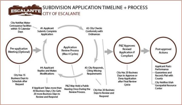
10.54.130 Approval And Post-Approval Actions
- The Land Use Authority shall approve any complete subdivision application made under this Chapter that complies with applicable City ordinances.
- The Land Use Authority shall issue all approvals in writing and shall certify the approved plat, either by signing the plat directly or by attaching a signed certification to the plat. In addition to the Land Use Authority’s signature, the Mayor, and a notary public shall sign the plat.
- The signatures of the Mayor, the notary public, and the owners of the land to be subdivided together function as transfer from the owners of the land and acceptance by the City of any public streets and other public parcels, easements, and uses that are described on the plat.
- The applicant shall record the approved plat with the County Recorder’s Office within 365 calendar days after the City approves the application, provided that the applicant has completed any public improvements or posted any performance guarantee required by City ordinances or described in the approved improvement plan. The applicant shall not record the approved plat until such public improvements are completed or guaranteed in compliance with City ordinances and the approved improvement plan.
- An approved plat not properly recorded within the timeline specified in this provision is void, unless the City Council approves an extension.
- The Land Use Authority shall submit to the Utah Geospatial Resource Center (so the subdivision can be included in the 911 database), within 30 calendar days after approving an application, either:
- An electronic copy of the approved plat; or
- Preliminary geospatial data that depict any new streets and situs addresses proposed for construction within the bounds of the approved plat.
10.54.140 Required Improvements
- The following improvements are required for all subdivisions, except those that qualify under the Agricultural Land exemption of Section 10.54.050.
- The plans for a sanitary sewer system shall be approved in writing by the city engineer.
- Storm Drainage:
- A storm water drainage system, or plan, approved by the city engineer shall be provided and shall be separate and independent from the sanitary sewer system. The plats for the drainage system shall be prepared under the direction of a licensed civil engineer and approved in writing by the city engineer prior to construction.
- No street or public way shall be used as storm drainage unless approved for such use by the city engineer.
- Electrical, Television, Internet, and Telephone Cables: All electrical, television, Internet, and telephone cables shall be installed underground except as otherwise directed by the city council.
- Street Improvements:
- At least ten (10) days prior to commencement of construction, the city engineer shall require the subdivider to furnish a complete set of construction plans and profiles of all streets, existing and proposed. within the subdivision. Plans are to be prepared under the direction of a licensed professional engineer and shall be accompanied by a copy of the approved plat. Within twenty (20) days of receipt, the city engineer shall notify the subdivider of approval or disapproval, and in case of disapproval, the reason thereof. Such plans and profiles shall include:
- The designation of limits of work to be done;
- Location of the benchmark and its true elevation according to city data and all profiles to be referred to that data;
- Construction plans, which shall include details of curb and gutter and street cross sections, location and elevations of manholes, catch basins and storm sewers, elevations and locations of fire hydrants and any other elevations or details necessary to simplify construction;
- Complete data for field layout and office checking;
- On curb returns, at least two (2) additional control points for elevation besides those at points of curvature. Control points shall be staked in the field to ensure proper drainage at intersections.
- Grades of streets shall not be in excess of eight (8) percent on major collector streets, nor in excess of fifteen (15) percent on other streets.
- Cul-de-sac streets shall not exceed eight hundred (800) feet in length.
- All streets within the subdivision shall be improved with chip seal or gravel, and may be required to be bonded by integral concrete curbs and gutters to an overall width in accordance with the standards, rules and regulations adopted by the city.
- Pavement shall be constructed in accordance with the requirements of the standard specifications adopted by the city.
- Sidewalks shall be concrete of the standard city specifications.
- Whenever storm water inlets and catch basins are to be used, they shall be provided within the roadway improvements at points specified by the city engineer.
- All curb corners shall have a radius of not less than fifteen (15) feet, except::
- At intersections involving collector or major streets the radius shall not be less than twenty-five (25) feet;
- In industrial areas, the radius shall not be less than twenty (20) feet.
- The arrangement of streets in new subdivisions shall make provisions for continuation of streets in adjoining areas, and shall provide access to un-subdivided adjoining areas in so far as such construction or access shall be deemed necessary by the Land Use Authority.
- Minor streets shall approach major or collector streets at an angle as near ninety (90) degrees as possible.
- The subdivider may be required to install curbs, gutters and sidewalks on existing and proposed urban streets within the subdivision.
- Street name signs, conforming to the design and specifications and the number required by the standards of the city, shall be provided by the subdivider at all street intersections. Inspection shall be made by the city engineer to ensure uniformity.
- Traffic control signs, including stop or yield right-of-way signs, shall be installed by the subdivider to ensure a smooth flow of traffic through the subdivision.
- A minimum center line radius of fifty (50) feet shall be maintained on all winding mountainous streets and a minimum of three hundred (300) feet shall be required for all through traffic streets.
- Private streets, alleys, or ways shall not be approved except when the Land Use Authority, after investigation, recommends and the city council, after hearing, find that public dedication is impractical. All alleys and private streets shall be improved as required by the Land Use Authority.
- Fire hydrants shall be installed in all subdivisions in accordance with the regulations of the International Fire Code.
- Open ditches or canals shall not be allowed.
- At least ten (10) days prior to commencement of construction, the city engineer shall require the subdivider to furnish a complete set of construction plans and profiles of all streets, existing and proposed. within the subdivision. Plans are to be prepared under the direction of a licensed professional engineer and shall be accompanied by a copy of the approved plat. Within twenty (20) days of receipt, the city engineer shall notify the subdivider of approval or disapproval, and in case of disapproval, the reason thereof. Such plans and profiles shall include:
- Water:
- All lots within the subdivisions shall use Escalante culinary water. The subdivider shall provide water lines and a service lateral to each lot in the subdivision.
- All water system plans shall be approved, in writing, by the city engineer and water superintendent prior to construction.
- Fences and Guards: In locations where a subdivision is adjacent to public or private grazing land, a fence of material and quality satisfactory to the city board shall be erected around the outer limits of the subdivision. The city may also require the installation of cattle guards on any street entering the proposed subdivision from public or private lands.
- Any other infrastructure (or infrastructure improvement) that is reasonably necessary to meet the needs of the proposed development.
10.54.150 Performance Guarantee/Completion Assurance
- The subdivider shall file with the City Clerk a completion assurance in an amount approved by the city engineer, but no more than 110% of the engineer's estimated cost of the improvement,to assure the actual construction of such improvements as has been required as a condition of approval of a subdivision plat. All such improvements shall have been installed within a period of two (2) years and shall be installed in a manner satisfactory to the subdivision Land Use Authority.
- The City shall accept any of the following forms of guarantee for an improvement:
- Surety or cash bond. The applicant may furnish a bond with corporate surety, which bond shall be approved by the City Attorney and filed with the City Recorder.
- Escrow. The applicant may make a deposit in escrow with an escrow holder approved by the City Council, under an escrow agreement approved by the City Attorney and filed with the City Recorder.
- Letter of Credit. The applicant may provide a letter of credit from a financial institution approved by the City Council, under an agreement to complete the improvements which is approved by the City Attorney and filed with the City Recorder.
- As improvements are completed, inspected, and accepted by the City, the City Council shall, each quarter, at the option of the applicant, issue a partial release of bonded or escrow funds proportional to the improvements accepted during the prior quarter.
- Upon completion of the improvements for which a completion assurance has been filed, the subdivider shall call for a final inspection by the city engineer. If the inspection shows that city standards have been met in the completion of such improvements, the bonds shall be released, and the city shall have no responsibility to assure that payment to contractors for the installation of said improvements has been made.
- Subject to improvement requirements contained in this Code, the City will not accept dedication of required improvements, or release or reduce a performance guarantee, until the City Engineer has submitted a certificate stating that all required improvements have been satisfactorily completed and until the applicant's engineer or surveyor has certified to the City Engineer, through submission of detailed "as-built" survey plats of, the subdivision, indicating location, dimensions, materials, improvements and other information required by the P&Z and City Engineer, that the layout of the line and grade of all public improvements is in accordance with the City-approved construction plans for the subdivision and that a title insurance policy has been furnished to the City and City Engineer indicating that the improvements have been completed, are ready for dedication to the local government and are free and clear of any and all liens and encumbrances.
- In no event shall a performance guarantee be reduced below 25% retainage of the principal amount until total completion.
- The subdivider may cause the improvements to be constructed upon the subdivided property by licensed and qualified contractors at any time after final approval of the subdivision plat by the Land Use Authority and prior to recording of the plat, provided said construction is accomplished according to the requirements of this chapter and under the supervision of the city engineer, and after payment of all filing and inspection fees.
- The City shall not require improvement guarantees for any of the prohibited uses listed in Utah Code §10-9a-604.5(3)(d), including improvements the City has previously inspected and accepted, private improvements that are not essential to meet the building code, fire code, flood or storm water management provisions, street and access requirements, or other essential necessary public safety improvements adopted in a land use regulation.
- If there is no activity within one year of the approval of the subdivision application, the application will become void and a new application will then have to be resubmitted following the subdivision rules in effect at the time of the new application.
- Once approval is given, work must commence in earnest within one year. If after the one-year period work has not commenced, the city can use the posted bond to bring any disturbed earth, trees, bushes, etc. back to its original natural state, with the rest of the posted bond returned to the subdivider. All subdivisions, once started, must be completed within two years. With approval of the Land Use Authority, these time frames may be extended because of just cause. For the sake of this chapter "work must commence in earnest" will mean that physical progress in the implementation of the requirements of the subdivision laws of Escalante City has commenced. Any arbitrary interpretation will favor Escalante City.
10.54.160 Generally
Standards for design, construction, specifications, and inspection of street improvements, curbs, gutters, sidewalks, fire hydrants, storm drains, flood control facilities, water distributions and sewage disposal facilities shall be approved by the city engineer and city council.
10.54.170 Fees
Any and all persons filing applications with the City Clerk, shall pay an office checking fee according to the following schedule:
- $50.00 as a minimum checking fee for subdivisions which contain three (3) lots or less.
- For subdivisions of four (4) lots or more, an additional charge of $50.00 shall be made for each lot over three (3).
- Plat Review ninehundred dollars $900.00
- Determination of Impact on Culinary Water System three hundred dollars $300.00.
- Determination of Impact on Sewer System (if applicable) three hundred dollars $300.00
- Additional fees may be required, depending on the physical or legal complication of the proposed subdivision.
10.54.180 Enforcement
The Planning and Zoning Commission, The City Council, and other such departments and agencies of the city government as are specified under the provisions of this title are designated and authorized as the agencies charged with the enforcement of the provisions of this title, and shall enter such actions in court as are necessary. Failure of such departments to pursue appropriate legal remedies will not legalize any violation of this title.
10.54.190 Inspection
Appropriate agencies and departments of the city shall inspect or cause to be inspected all buildings, fire hydrants and water supply and sewage disposal systems in the course of construction, installation or repair. Excavations for fire hydrants and water mains and laterals shall not be covered or back filled until such installations have been approved by the city engineer or building inspector. If any such installation is covered before being inspected and approved, it shall be uncovered after notice to uncover has been issued to the responsible person by the inspector.
Adopted by Ord. 1987-1 sec. 6-3 on 1/1/1987
10.54.200 Permits
From the time of the effective date of the ordinance codified in this chapter, the building inspectors shall not grant a permit, nor shall any city officer grant any license or permit for the use of any land or the construction or alteration of any building or structure on a lot, which would be in violation of any provision of this chapter, until a subdivision plat thereof has been recorded or approved as herein required. Any license or permit issued in conflict with this section shall be voided.
Adopted by Ord. 1987-1 sec. 6-4 on 1/1/1987
10.54.210 Violation
No person shall subdivide any tract or parcel of land located wholly or in part in the city except in compliance with the provisions of this chapter. No person shall purchase, sell or exchange any parcel of land which is any part of a subdivision or a proposed subdivision submitted to the Planning and Zoning Commission, nor offer for recording in the office of the county recorder, any deed conveying such parcel of land or any interest therein, unless such subdivision has been created pursuant to and in accordance with the provisions of this chapter.
Adopted by Ord. 1987-1 sec. 6-6 on 1/1/1987
10.54.220 Penalty
10.54.230 Repealer
10.54.240 Amendments
- The City Council may vacate a subdivision or a portion of a subdivision by enacting an ordinance to that effect that describes the subdivision or the portion being vacated and recording that ordinance in the County Recorder’s Office.
- A fee owner of land in a platted subdivision may request a material subdivision amendment by filing a written petition with the City Council. This petition must meet all the requirements for a subdivision application specified in Section 10.54.100, with the following changes:
- The plat (or the record of survey map, if applicable) should:
- Depict only the portion of the subdivision that is proposed to be amended;
- Include a plat name distinguishing the amended plat from the original plat;
- Describe the differences between the amended plat and the original plat;
- Include references to the original plat; and
- Meet all the other plat requirements specified in Section 10.54.100(C).
- The petition must additionally include the name and address of each property owner affected by the petition and the signature of each of those property owners who consents to the petition.
- The petitioner must include with the petition envelopes addresses to each property in the subdivision.
- The plat (or the record of survey map, if applicable) should:
- Upon receipt of an amendment petition, the City Council (or City staff, as delegated) shall provide notice of the petition to:
- Each utility provider that services a parcel of the subdivision. The City shall not approve an amendment petition until at least 10 calendar days after noticing these utility providers. The City may notify the utility providers in any effective manner (email, mail, etc.).
- Each property owner in the subdivision. The City shall notify these property owners by mail.
- The City Council shall hold a public hearing before approving an amendment petition and within 45 calendar days after the day on which the petition is submitted if:
- A property owner objects in writing to the amendment within 10 days of the City notifying the property owner by mail, or
- Not every property owner in the subdivision has signed the revised plat.
- Notwithstanding Section 10.54.240(E), the P&Z need not hold a public hearing if notice has been given to adjoining property owners in accordance with any applicable local ordinance and the petition seeks to:
- Join two or more of the petitioner’s contiguous lots;
- Subdivide one or more of the petitioner's lots;
- Adjust the lot lines of adjoining lots or between a lot and an adjoining parcel if the fee owners of each of the adjoining properties join in the petition, regardless of whether the properties are located in the same subdivision;
- On a lot owned by the petitioner, adjust an internal lot restriction imposed by the local political subdivision; or
- Alter the plat in a manner that does not change existing boundaries or other attributes of lots within the subdivision that are not owned by the petitioner or designated as a common area.
- If the City Council approves the amendment petition, the City Council shall sign the amended plat in the manner described in Section 10.54.130(B), and the petitioner shall record the plat, subject to the completion or guarantee of any improvements, as described in Section 10.54.130(C)
10.54.2500 Lot Line Adjustments; Approval
- The fee owners of two parcels may adjust their lot lines and record the amendments without a subdivision amendment. Such a petition shall include:
- A record survey map and a metes-and-bounds description showing the adjustment.
- An explanation of the reason for adjustment.
- Signatures from all the parcel owners involved in the adjustment.
- A map indicating the present lot boundaries and the boundaries as they will be upon completion of the lot line adjustment.
- A legal description of both affected properties describing the lots as they will exist after the lot line adjustment.
- Any other information the P&Z requests.
- If the adjustments will not result in a violation of a land use ordinance or an adverse development condition, the P&Z shall approve the petition. The lot line adjustment shall not result in a remnant piece of land that did not exist previously. Lot adjustments that are recorded and do not meet the above conditions shall be considered a violation of this ordinance.
- If the adjustment is approved, the P&Z shall sign the record of survey map and accompanying metes-and-bounds description, and the petitioner shall record the document in the County Recorder’s Office.
- Upon approval the legal descriptions from the applicant shall be recorded at the Garfield County Recorder's Office as an amendment to existing parcels or subdivision plat as appropriate. The lot line adjustment shall not be considered complete until this action is taken and a copy is received by the City.
- Upon approval the legal descriptions from the applicant shall be recorded at the Garfield County Recorder's Office as an amendment to existing parcels or subdivision plat as appropriate. The lot line adjustment shall not be considered complete until this action is taken and a copy is received by the City.
10.54.260 Single Parcel Split; Approval
Property owners may split their parcel and record the amendments of the appropriate subdivision plat or deeds of records if the following conditions are met:
- No Parcel may be split more than once in five years.
- Owner's Responsibilities:
- The owners seeking approval for a single parcel split shall present to the City Office a map indicating the present parcel boundaries and the boundaries as they will be upon completion of the single parcel split.
- Upon approval , a new legal description of both resulting parcels shall be recorded at the Garfield County Recorder's office. The single parcel split shall not be considered complete until this action is taken and a copy is received by the City.
. - Water Meter:
- Must be on the property of the existing service; and Must
- must be moved at the expense of the property owner to accommodate the existing service.
- City Responsibilities:
- Upon receiving the materials described above, the City shall review the map to ensure that:
- Both resulting parcels shall each have sufficient acreage to meet the minimum required area for the zone(s) in which the lots exist.
- Both resulting parcels meet the minimum required width required for the zone(s) in which the lots exist.
- Upon receiving the materials described above, the City shall review the map to ensure that: