
Fayetteville City Zoning Code
CHAPTER 165
- AIRPORT ZONE
165.01 - Airport Zones; Establishment
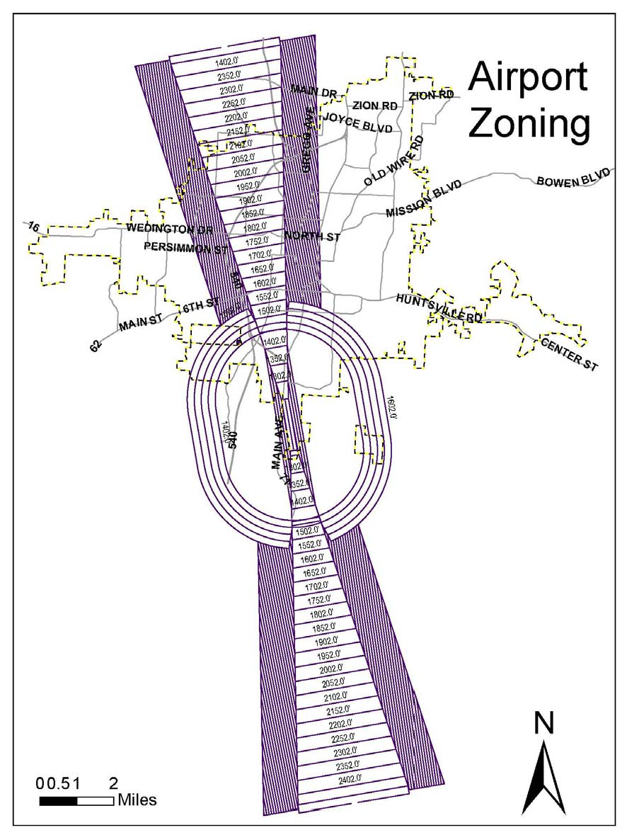
There are hereby created and established zones, which zones include all the land lying beneath the approach surfaces, transitional surfaces, horizontal surfaces, and conical surfaces as they apply to the municipal airport. Said zones are shown on the airport zoning map consisting of one sheet, which shall be made a part hereof by reference. An area located in more than one of the following zones is considered to be only in the zone with the more restrictive height limitation. The various zones are hereby established and defined as follows:
(A)
Runway Larger Than Utility Visual Approach Zone. The inner edge of this approach zone coincides with the width of the primary surface and is 500 feet wide. The approach zone expands outward uniformly to a width of 1,500 feet at a horizontal distance of 5,000 feet from the primary surface. Its centerline is the continuation of the centerline of the runway.
(B)
Precision Instrument Runway Approach Zone. The inner edge of this approach zone coincides with the width of the primary surface and is 1,000 feet wide. The approach zone expands outward uniformly to a width of 16,000 feet at a horizontal distance of 50,000 feet from the primary surface. Its centerline is the continuation of the centerline of the runway.
(C)
Transitional Zones. The transitional zones are the areas beneath the transitional surfaces.
(D)
Horizontal Zone. The horizontal zone is established by swinging arcs of 5,000 feet radii for all runways designated utility or visual and 10,000 feet for all others from the center of each end of the primary surface of each runway and connecting the adjacent arcs by drawing lines tangent to those arcs. The horizontal zone does not include the approach and transitional zones. The radius used shall be the longest determined for either end.
(E)
Conical Zone. The conical zone is established as the area that commences at the periphery of the horizontal zone and extends outward therefrom a horizontal distance of 4,000 feet.
(Code 1965, App. B., §III; Ord. No. 2697, 1-20-81; Code 1991, §150.03; Ord. No. 4100, §2 (Ex. A), 6-16-98)
165.02 - Airport Zone Height Limitations
Except as otherwise provided in this chapter, no structure shall be erected, altered, or maintained, and no tree shall be allowed to grow in any zone created by this chapter to a height in excess of the applicable height established for such zone. Such applicable height limitations are hereby established for each of the zones in question as follows:
(A)
Runway Larger Than Utility Visual Approach Zone. Slopes 20 feet outward for each foot upward beginning at the same elevation as the primary surface and extending to a horizontal distance of 5,000 feet along the extended runway centerline.
(B)
Precision Instrument Runway Approach Zone. Slopes 50 feet outward for each foot upward beginning at the end of and at the same elevation as the primary surface and extending to a horizontal distance of 10,000 feet along the extended runway centerline; thence slopes upward 40 feet horizontally for each foot vertically to an additional horizontal distance of 40,000 feet along the extended runway centerline.
(C)
Transitional Zones. Slopes 7 feet outward for each foot upward beginning at the sides of and at the same elevation as the primary surface and the approach surface, and extending to a height of 150 feet above the airport elevation which is 1,251 feet above mean sea level. In addition to the foregoing, there are established height limits sloping 7 feet outward for each foot upward beginning at the sides of and the same elevation as the approach conical surface. Where the precision instrument runway approach zone projects beyond the conical zone, there are established height limits sloping 7 feet outward for each foot upward beginning at the sides of and the same elevation as the approach surface, and extending a horizontal distance of 5,000 feet measured at 90° angles to the extended runway centerline.
(D)
Horizontal Zone. 150 feet above the airport elevation; 1,401 feet above mean sea level.
(E)
Conical Zone. Slopes 20 feet outward for each foot upward beginning at the periphery of the horizontal zone and at 150 feet above the airport elevation and extending to a height of 350 feet above the airport elevation.
(F)
Excepted Height Limitation. Nothing in this chapter shall be construed as prohibiting the construction or maintenance of any structure, or the growth of any tree, to a height up to 25 feet above the surface of the land; provided, the 25 foot height limitation prescribed hereby shall not apply where the Federal Aviation Administration has approved a greater height limitation.
(G)
Primary Surface Elevation. The elevation of any point on the primary surface is the same as the elevation of the nearest point on the runway centerline.
(Code 1965, App. B., §1, IV; Ord. No. 2697, 1-20-81; Ord. No. 3027, 8-21-84; Code 1991, §§150.02, 150.04; Ord. No. 4100, §2 (Ex. A), 6-16-98)
165.03 - Use Restriction
Notwithstanding any other provisions of this chapter, no use may be made of land or water within any zone established by this chapter in such a manner as to create electrical interference with navigational signals or radio communication between the airport and aircraft; make it difficult for pilots to distinguish between airport light and other, result in glare in the eyes of pilots using airport; impair visibility in the vicinity of the airport; create bird strike hazards; or otherwise in any way endanger or interfere with the landing, takeoff or maneuvering of aircraft intending to use the airport.
(Code 1965, App. B., § V; Ord. No. 2797, 1-20-81; Code 1991, §150.05; Ord. No. 4100, §2 (Ex. A), 6-16-98)
165.04 - Nonconforming Uses
(A)
Permit Authorizing Continuance. The owner of any structure or object of natural growth existing at the time of the adoption of this chapter which does not conform hereto shall be granted a permit authorizing continuance of such nonconforming use upon application therefore by him to the Building Safety Division Director; provided, if such application is not made within ninety (90) days of the effective date of this chapter, said owner shall be compelled, at his expense, to lower or remove such object to the extent necessary to conform to this chapter.
(B)
Alterations. Before any existing nonconforming structure or object of natural growth for which a permit has been issued in accordance with subsection (A) of this section may be altered or repaired, rebuilt, allowed to grow higher, or replanted, a permit must be secured from Building Safety Division Director authorizing such change or repair.
(1)
Increased Hazard. No such permit shall be granted that will permit the structure or object of natural growth in question to be made higher or become a greater hazard to air navigation than it was when the permit for the continuance was granted under (A) above.
(2)
50% Destroyed. Where the structure or object of natural growth has been more than 50% torn down or destroyed, whether voluntarily, by activity, or otherwise, or has become more than 50% deteriorated or decayed, no permit shall be granted that will permit such structure or object of natural growth to exceed the applicable height limit prescribed by the zoning regulations; instead, in all such cases of 50% destruction, deterioration, or decay, whether application is made for a permit for repair or not, the inspections division director shall compel the owner of the nonconforming structure or object of natural growth such object to the extent necessary to conform to the said height limit.
(C)
Change or Repair. Except as indicated, all applications for permits for change or repair of nonconforming uses shall be granted.
(Code 1965, App. B., § VI; Ord. No. 2697, 1-20-81; Code 1991, §150.06; Ord. No. 4100, §2 (Ex. A), 6-16-98)
165.05 - Permits
(A)
Required. Except as specifically provided in this section, no material change shall be made in the use of land, no structure shall be erected or otherwise established, and no tree shall be planted in any zone hereby created unless a permit therefore shall have been applied for and granted by the Building Safety Division.
(B)
Application. Each application for a permit shall indicate the purpose for which the permit is desired, with sufficient particularity to permit it to be determined whether the resulting use, structure or tree would conform to the regulations herein prescribed. If such determination is in the affirmative, the permit shall be granted.
(C)
Exception.
(1)
Less Than 75 Feet Vertical Height. In the area lying within the limits of the horizontal zone and conical zone, no permit shall be required for any tree or structure less than 75 feet of vertical height above the ground, except when, because of terrain, land contour, or topographic features, such tree or structure would extend above the height limits prescribed for such zones.
(2)
Approach Zone. In areas lying within the limits of the approach zones, but at a horizontal distance of not less than 4,200 feet from each end of the runway, no permit shall be required for any tree or structure less than 75 feet of vertical height above the ground, except when such tree or structure would extend above the height limit prescribed for such approach zones.
(3)
Excessive Heights. Nothing contained in any of the foregoing exceptions shall be construed as permitting or intending to permit any construction or alteration of any structure or growth of any tree in excess of any of the height limits established by this chapter except as set forth in §165.02(D).
(Code 1965, App. B., §VII; Ord. No. 2697, 1-20-81; Code 1991, §150.07; Ord. No. 4100, §2 (Ex. A), 6-16-98)
165.06—165.99 - Reserved
(Ord. 5186, 10-21-08)