
Fayetteville City Zoning Code
CHAPTER 169
- PHYSICAL ALTERATION OF LAND
169.01 - Intent
(A)
It is the city's intent to safeguard the health, safety, and welfare of Fayetteville citizens by implementing standards and procedures for the physical alteration of land. It is not the city's intent to supersede federal or state regulations such as, but not limited to, the Occupational Health & Safety Act.
(B)
The purpose of this chapter is to control grading, clearing, filling, excavation, or land alteration of any kind which alone or in combination cause landslides, flooding, degradation of water quality, erosion and sedimentation in storm sewer systems and water storage basins. It is also the intent of this chapter that through the implementation of the guidelines and regulations contained herein, the existing scenic character and quality of the neighborhood and city as a whole not be diminished.
(Code 1991, §161.01; Ord. No. 3551, 6-4-91; Ord. No. 4100, §2 (Ex. A), 6-16-98; Ord. No. 4113, §1, 8-18-98; Ord. No. 5336, 8-3-10; Ord. No. 5702, Repealed & Replaced Chp. 169, 8-5-14; Ord. No. 6061, §3, 4-17-18)
169.02 - General Requirements
(A)
Protection. Persons engaged in land alteration activities regulated by this chapter shall take measures to protect public and private properties from damage by such activities. Adjacent and nearby properties affected by land alterations shall be restored in accordance with the requirements of this chapter.
(B)
Site Conditions. Development shall generally conform to the natural contours of the land, natural drainage ways, and other existing site conditions.
(C)
Adjacent Properties. All developments shall be constructed and maintained so that adjacent properties are not unreasonably burdened with surface waters as a result of such development. More specifically, new development may not unreasonably impede water runoff from higher properties nor may it unreasonably channel water onto lower properties.
(D)
Restoration. Land shall be revegetated and restored as close as practically possible to its original conditions so far as to minimize runoff and erosion are concerned. Previously forested areas shall follow the City's Landscape Manual for mitigation of forested areas.
(Code No. 1991, §161.02; Ord. No. 3551, 6-4-91; Ord. No. 4100, §2 (Ex. A), 6-16-98; Ord. No. 4113, §1, 8-18-98; Ord. No. 4855, 4-18-06; Ord. No. 5336, 8-3-10; Ord. No. 5431, 8-16-11; Ord. No. 5702, Repealed & Replaced Chp. 169, 8-5-14)
169.03 - Review And/Or Permits Required; Exceptions
(A)
Grading Review Required. (Reference §166.02(E).)
(1)
When located within the Hillside/Hilltop Overlay District boundaries. Parcels of land divided by the Hillside/Hilltop Overlay District boundary shall only be subject to the requirements of this chapter on that portion of land lying within the boundary;
(2)
Construction of greater than 1,200 square feet of impervious area on a single site;
(B)
Grading Permit Required. Unless exempted by §169.03(C), all grading, clearing, filling (including the placement of mulch or compost), excavation, land alteration of any kind, or construction of new impervious area greater than 10,000 feet shall require:
(1)
Prior development approval as specified in Chapter 166, except for general grading to an existing developed site that does not impact trees or floodplains and does not significantly alter the natural landform;
(2)
Development and/or redevelopment of an area of more than 10,000 square feet of impervious surface;
(3)
An Arkansas Department of Environmental Quality Stormwater Construction Permit and incorporated Stormwater Pollution Prevention Plan, if required by state law.
(C)
Exceptions to Permit Requirements. Grading permits are not required for the following however the Minimum Erosion Control Requirements in §169.04 still apply:
(1)
Excavation Below Finish Grade. Excavations below finished grade for basements, swimming pools, hot tubs, septic systems, retaining walls under 4 feet in height, and like structures authorized by a valid building permit.
(2)
Cemetery Graves. Cemetery graves.
(3)
Refuse Disposal. Refuse disposal sites controlled by other regulations.
(4)
Other minor fill, clearing or grading for maintenance purposes such as landscaping that do not require the use of heavy construction equipment, French drains, yard grading, maintenance, farming, gardens, and similar activities.
(5)
Placement of mulch, compost, topsoil or like material at reasonable depths of six (6) inches or less for purposes of creating or enhancing landscape beds, gardens, or lawn areas, in accordance with accepted best practices and industry standards for such areas.
(D)
Grading Permit Application and Approval. No grading permit shall be issued until the Grading and Erosion & Sediment Control Plan, endorsed by an architect, landscape architect, or engineer licensed in the state of Arkansas, is approved by the City Engineer. A separate permit shall be required for each site. Grading permits may be issued jointly for parcels of land that are contiguous, so long as erosion control measures are in place until project completion. Any application for a required grading permit under this chapter shall be submitted concurrently with the application and calculations for a drainage permit if such a drainage permit is required by §170.03. Tree Preservation and Protection is required in accordance with Chapter 167.
(E)
Permit Posted. A copy of the grading permit cover page shall be posted at or near the street right-of-way line and shall be clearly visible from the street.
(Code 1991, §161.03; Ord. No. 3551, 6-5-91; Ord. No. 4100, §2 (Ex. A), 6-16-98; Ord. No. 4113, §1, 8-18-98; Ord. No. 4313, 5-15-01; Ord. No. 4855, 4-18-06; Ord. No. 5336, 8-3-10; Ord. No. 5702, Repealed & Replaced Chp. 169, 8-5-14; Ord. No. 5945, §18, 1-17-17; Ord. No. 6061, §4, 4-17-18; Ord. No. 6446, §11(Exh. F), 6-15-21; Ord. No. 6766, §§ 1, 2, 7-2-24; Ord. No. 6785, § 7, 8-20-24)
169.04 - Minimum Erosion Control Requirements
If exempt under §169.03, a grading permit is not required. However, exempt as well as non-exempt activities shall be subject to the following minimum erosion and sedimentation control measures.
(A)
The City Council hereby adopts by reference the Drainage Criteria Manual, prepared for the City of Fayetteville, and adopted by Ordinance No. 5702 of the City of Fayetteville and as may be amended from time to time by the City Engineer. All minimum erosion and sediment control standards contained therein shall have the same force and effect as if printed word for word in this chapter. Development projects also must comply with their Arkansas Department of Environmental Quality general construction permit. All projects shall follow Chapter 8, Construction Site Stormwater Management, of the Drainage Criteria Manual as well to achieve site compliance.
(B)
Stabilization. A record of the dates when grading activities occur, when construction activities temporarily or permanently cease on a portion of the site, and when stabilization measures are initiated shall be included in the erosion and sediment control plan. Except as provided in subsections (1) and (2) below, stabilization measures shall be initiated as soon as practicable in portions of the site where construction activities have temporarily or permanently ceased, but in no case more than fourteen (14) days after the construction activity in that portion of the site has temporarily or permanently ceased.
(1)
Where the initiation of stabilization measures by the fourteenth day after construction activity temporarily or permanently ceases is precluded by snow cover, stabilization measures shall be initiated as soon as practicable.
(2)
Where construction activity will resume on a portion of the site within twenty-one (21) days from when activities ceased, (e.g., the total time period that construction activity is temporarily ceased is less than twenty-one (21) days) then stabilization measures do not have to be initiated on that portion of the site by the fourteenth day after construction activity temporarily ceased.
(3)
Stabilization practices may include: temporary seeding, permanent seeding, mulching, geotextiles, sod stabilization, vegetative buffer strips, protection of trees, and preservation of mature vegetation and other appropriate measures. See Chapter 167 of the UDC for tree protection requirements.
(C)
Intermittent/Perennial Streams. Grading activities will meet the Streamside Protection Requirements found in §168.12, Streamside Protection Zones. Fording of streams with construction equipment or other activities which destabilize stream banks shall not be permitted. In instances where streams are not protected under §168.12, no intermittent or perennial stream, including a 25-foot perimeter strip measured from the top of the bank, shall be graded, developed, channeled, or physically altered unless adequate guarantees are made for erosion and sedimentation control both during construction and post construction. Likewise, cuts or fills shall be setback sufficiently from intermittent and perennial streams and other stormwater drainage systems to guarantee that there will be no damage from erosion or sedimentation. Final erosion and sedimentation control measures shall be approved by the City Engineer.
(D)
Excavation Material. Excavation material shall not be deposited in or so near streams and other stormwater drainage systems where it may be washed downstream by high water or runoff. All excavation material shall be stabilized immediately with erosion control measures.
(Code 1991, §161.04; Ord. No. 3551, 6-5-91; Ord. No. 3947, §1, 2-6-96; Ord. No. 4100, §2 (Ex. A), 6-16-98; Ord. No. 4113, §1, 8-18-98; Ord. 4855, 4-18-06; Ord. No. 5336, 8-3-10; Ord. No. 5702, Repealed & Replaced Chp. 169, 8-5-14; Ord. No. 6061, §5, 4-17-18; Ord. No. 6446, §11(Exh. F), 6-15-21)
169.05 - One-Time Approvals
(A)
Utilities. Public and private utility organizations may obtain a one-time approval from the City Engineer for all routine underground electric, water, sewer, natural gas, telephone, or cable facilities. The approval will include a utility organization and its contractors, agents, or assigns and will be permanent in nature as long as the original approved procedures are followed.
(B)
Stockpiling Materials. One-time approval may be obtained by public or private entities for the stockpiling of fill material, rock, sand, gravel, aggregate, or clay at particular locations, subject to Zoning, Chapters 160 through 165.
(Code 1991, §161.05; Ord. No. 3551, 6-4-91; Ord. No. 4100, §2 (Ex. A), 6-16-98; Ord. No. 5336, 8-3-10; Ord. No. 5702, Repealed & Replaced Chp. 169, 8-5-14)
169.06 - Land Alteration Requirements
(A)
Applicability. This section shall apply to all land alteration activities, including those that do not require a grading permit.
(B)
Requirements Varied. Variances of this chapter's requirements may be approved by the City Engineer. The extent to which variations may be made will depend on the soil types encountered, planned slopes, planned vegetation, and investigative engineering reports. In no case shall the City Engineer waive or modify any of the minimum erosion control requirements as given in §169.04.
(C)
Cut or Fill Slopes.
(1)
Finish Grade. Cut or fill slopes shall have a finish grade no steeper than 33% (3.00 horizontal to 1 vertical), unless otherwise approved by the City Engineer. Land located within the Hillside/Hilltop Overlay District may have cut or fill slopes with a finish grade no steeper than 50% (2.00 horizontal to 1 vertical) unless otherwise approved by the City Engineer.
(2)
Maximum Length. The maximum length of any cut or fill slope without a terrace (as described in §169.06(D) and (E) below) shall be 100 feet as measured along the ground. The terrace shall be at least 6 feet wide.
(3)
Existing Topography. Cut or fill slopes shall be constructed to eliminate sharp angles of intersection with the existing terrain and shall be rounded and contoured to blend with the existing topography.
(4)
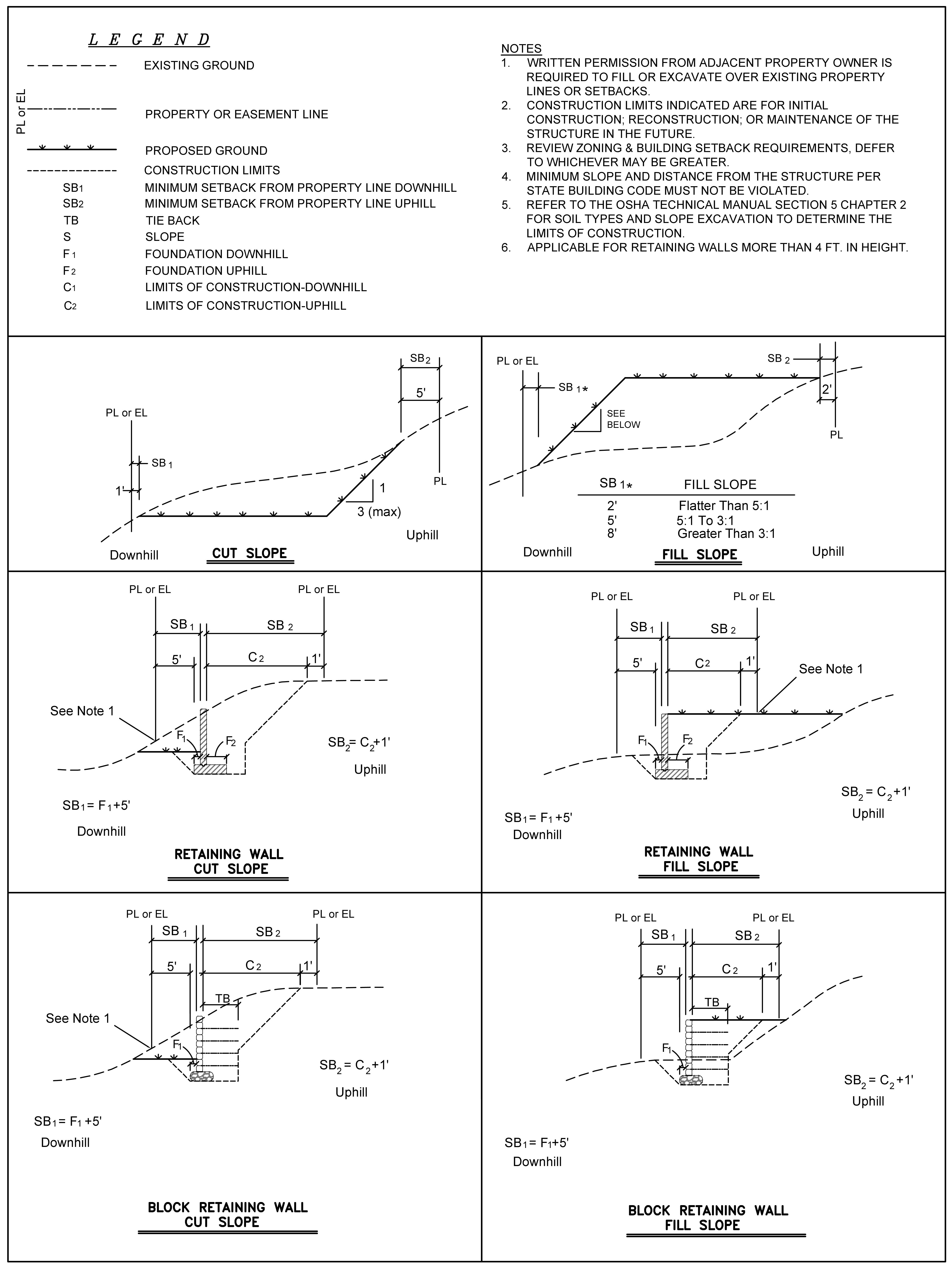
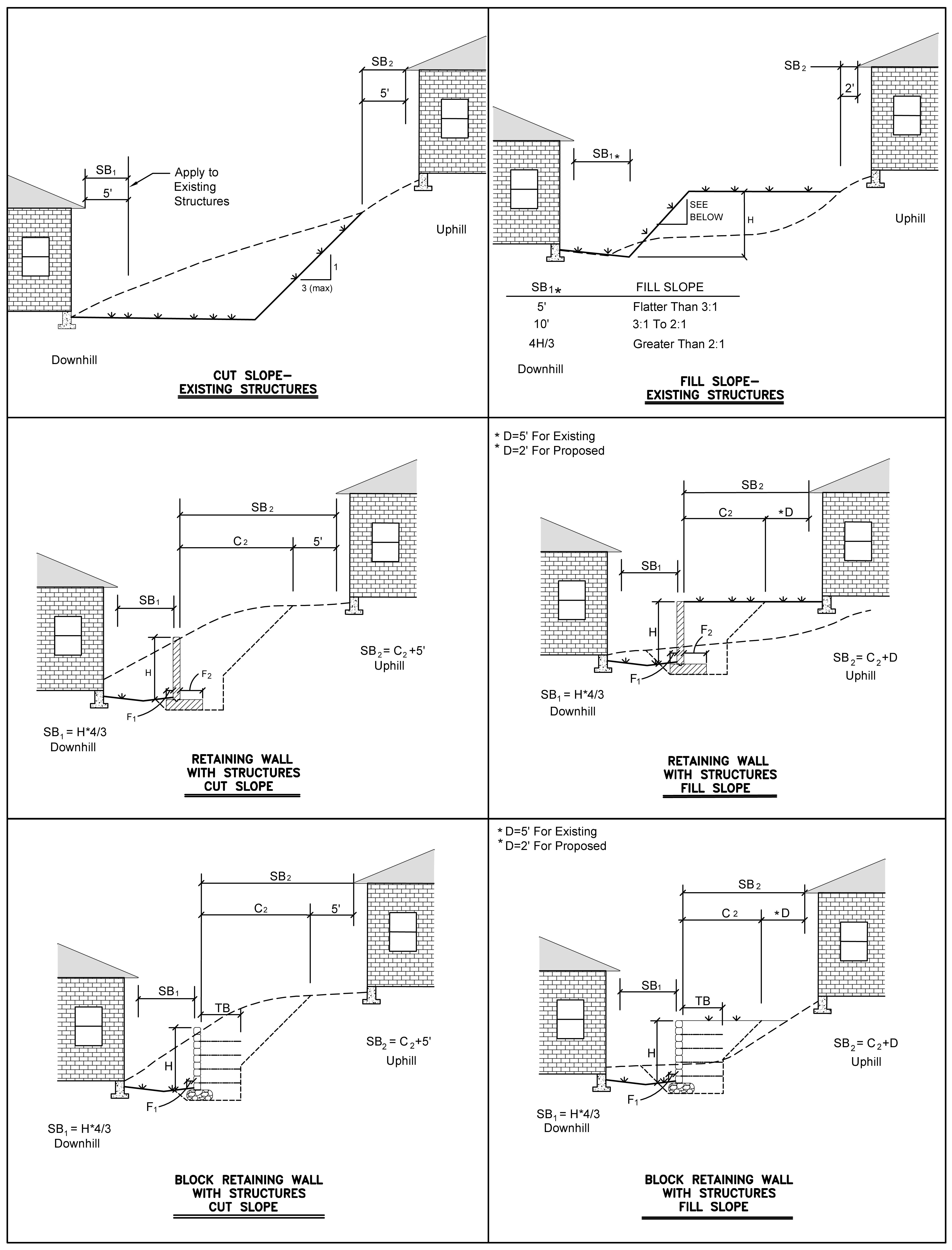
Setback Requirements. The following setback requirements shall be reviewed by the City Engineer for purposes of assessing safety, stability, and drainage problems: (See illustrations).
(a)
Setback from Top or Toe of Cut or Fill. Buildings shall be setback from the top or toe of a cut or fill in accordance with Zoning, Chapters 160 through 165; Building Regulations, Chapter 173; or the approved grading plan, whichever is greatest.
(b)
Setbacks from Property Lines. The required setback of retaining walls, cut slopes, and fill slopes from property lines shall be as given in the illustrations. Property lines may be filled over or cut if a grading plan for the cut or fill is submitted jointly by the owner of both properties or with written permission from the adjacent property owner and if no utility easements are involved. If utility easements are involved, approval is required as given in (c) below in addition to the joint submittal requirement.
(c)
Setbacks from the Edge of an Easement. The required setback of retaining wall, cut slopes, and fill slopes from the edge of easements shall be as given in the illustrations. Where no utilities are present in an easement, or where utilities are planned to be relocated, and where such action is approved by all utilities, in writing, then easements may fall within a cut or fill section.
(d)
Setbacks from Structures. The required setback of retaining walls, cut slopes, and fill slopes from structures shall be as given in the illustrations. If a structure forms an integral part of the retaining wall, then the setbacks do not apply to that structure.
(e)
Calculating Setbacks. For the purpose of calculating setbacks, any cut or fill section which is on a slope of one (1) to one (1) or greater shall be considered a retaining wall.
(f)
Administrative Variance. Setbacks from easement lines and structures may be varied administratively by the City Engineer if geotechnical and/or structural information is provided that in the opinion of the City Engineer justifies the variance.
(g)
Additional Information Required. The City Engineer may require further geotechnical and/or structural information to show that setbacks greater than those given are not needed to protect property, utilities, or the integrity of property lines.
(D)
Cuts.
(1)
Vertical Height. Cuts shall be limited to 10 feet in vertical height unless information demonstrating slope stability, erosion control, and drainage control is provided together with a re-vegetation plan. For nonsolid rock cuts, terraces shall be required for cuts greater than 10 feet in height. It is recommended that terracing be at a maximum ratio of 1 foot of horizontal terrace for every foot of vertical surface.
(2)
Maximum Vertical Cut. In solid rock, as determined by geotechnical and engineering data approved by the City Engineer, the maximum vertical cut shall be 30 feet.
(3)
Fill Material. In no case shall a cut be allowed primarily for the purpose of obtaining fill material to a different site, unless the exporting site is located within an extraction district.
(E)
Fills.
(1)
Rocks/Fill. All imported fill shall be free of rocks greater than twelve (12) inches in diameter and any detrimental organic material or refuse debris.
(2)
Compaction. Fill shall be placed and compacted as to minimize sliding or erosion of soil. Fill compaction shall equal the compaction of undisturbed, adjacent soil, except fills covered by Building Regulations, Chapter 173, or other structural fills. The City Engineer may require soil tests during compaction work or upon its completion at the expense of the permittee.
(3)
Grade. Fill shall not be placed on existing slope with a grade steeper than 15% (6.67 horizontal to 1 vertical) unless keyed into steps in the existing grade and thoroughly stabilized by mechanical compaction.
(4)
Vertical Height. Fills shall be limited to 10 feet in vertical height unless information demonstrating slope stability, erosion control, and drainage control is provided together with a re-vegetation plan.
(5)
Terraces. Terraces shall be required for fills greater than 10 feet in height. It is recommended that terracing be at a maximum ratio of one foot of horizontal terrace for every foot of vertical surface.
(F)
Erosion and Sedimentation Control.
(1)
Permanent Improvements. Permanent improvements such as streets, storm sewers, curb and gutters, and other features for control of runoff shall be scheduled coincidental to removing vegetative cover from the area so that large areas are not left exposed beyond the capacity of temporary control measures.
(2)
Phased Construction. The area of disturbance onsite at any one time shall be limited to 10 acres. An additional 10 acres (a maximum of 20 acres of disturbance at any one time) may be stripped with the permission of the City Engineer in order to balance cut and fill onsite. No additional area may be open without the permission of the City Engineer until the previously disturbed areas have been temporarily or permanently stabilized.
(3)
Stockpiling of Top Soil. Top soil may be stockpiled and protected for later use on areas requiring landscaping. All storage piles of soil, dirt or other building materials (e.g., sand) shall be located more than 25 feet from a roadway, drainage channel or stream (from top of bank), wetland, and stormwater facility. The City Engineer may also require top soil stockpiles to be located up to 50 feet from a drainage channel or stream, as measured from the top of the bank to the stockpile, for designated protected streams; established TMDL water bodies; streams listed on the State 303(d) list; an Extraordinary Resource Water, Ecologically Sensitive Waterbody, and/or Natural and Scenic Waterbody, as defined by Arkansas Pollution Control and Ecology Commission Regulation No. 2; and/or any other uses at the discretion of the City Engineer.
Topsoil piles surfaces must be immediately stabilized with appropriate stabilization measures. Stabilization practices may include: temporary seeding (i.e. annual rye or other suitable grass), mulching, and other appropriate measures. Sediment control measures such as buffer strips, wattles, or silt fence shall be provided immediately for stockpiles and remain in place until other stabilization is in place. Storm drain inlets must be protected from potential sedimentation from storage piles by silt fence or other appropriate barriers.
Properly stabilized topsoil stockpiles may be used for sedimentation control.
(4)
Plant/Water. Plant materials shall be watered or irrigated and tended. Where irrigation or regular watering is not available, only native or acclimated plant species shall be used. If the soil cannot properly sustain vegetation, it must be appropriately amended. If re-vegetation is not firmly established and healthy after one (1) year, the urban forester shall require that it be redone in part or total.
(5)
Permanent Erosion Control. The developer shall incorporate permanent erosion control features at the earliest practical time. Temporary erosion control measures will be used to correct conditions that develop during construction that were unforeseen during the design stage, that are needed prior to installation of permanent erosion control features, or that are needed temporarily to control erosion that develops during normal construction projects, but are not associated with permanent control features on the project.
(G)
Percentage of Land Disturbance. Land disturbance percentage within the Hilltop/Hillside Overlay District shall be equal to with the percent minimum canopy required on site per Chapter 167, Tree Preservation and Protection.
(H)
Required Retaining Wall and Rock Cut Design.
(1)
Design/Inspection. Any retaining wall more than 4 feet in height shall be designed by an Arkansas registered professional engineer, and shall be field inspected by the design engineer. The design engineer shall provide proof of inspection and certify that the wall was constructed in conformance with the design. The City Engineer may require retaining walls less than 4 feet in height to be designed by a professional engineer.
(2)
Investigation/Report. All proposed rock cuts and any cut or fill 10 feet or greater will require a geotechnical investigation and a formal report submitted by a registered professional engineer qualified to make such investigations.
(3)
Safety Railings. Safety railings may be required on any retaining wall 2.5 feet or higher. The decision as to whether to require safety railing shall be based on potential pedestrian and public access to the retaining wall and applicable building codes. This requirement for safety rails shall also apply to vertical or near vertical rock cuts and to steep (greater than 3:1) cut or fill slopes.
(Code 1991, §161.07; Ord. No. 3551, 6-4-91; Ord. No. 4100, §2 (Ex. A), 6-16-98; Ord. No. 4113, §1, 8-18-98; Ord. No. 4855, 4-18-06; Ord. No. 5336, 8-3-10; Ord. No. 5431, 8-16-11; Ord. No. 5702, Repealed & Replaced Chp. 169, 8-5-14; Ord. No. 6061, §6, 4-17-18; Ord. No. 6446, §11(Exh. F), 6-15-21)
169.07 - Grading Plan Specifications
(A)
Grading Plan. The applicant shall prepare a grading plan for all developments of greater than 6,001 square feet of impervious area as follows:
(1)
Site Plan. Site plan showing property lines; vicinity map; name of owner, developer and adjacent property owners.
(2)
Existing Grades. Existing grades shall be shown with dashed line contours and proposed grades with solid line contours. Grading plans shall be required to show both the proposed grade and the undisturbed area. Contour intervals shall be a maximum of 2 feet. Spot elevations shall be indicated.
(3)
Designation of Grade. Areas with 0 to 10%, 10 to 15%, 15 to 20% and more than 20% grade shall each be identified in a distinguishing manner.
(4)
Identify Land to Be Disturbed. Land areas to be disturbed shall be clearly identified.
(5)
Engineer/Architect. Seal of an Arkansas registered engineer or landscape architect certifying that the plan complies with this chapter.
(6)
Cuts and Fills. All cuts and fills, including height and slope, shall be clearly shown on the plan.
(7)
Streets and Rights-of-Way. Location and names of all existing or platted streets or rights-of-way within or adjacent to tract and location of all utilities and easements within or adjacent to the property shall all be indicated.
(8)
Lot/Building, Etc., Identification. The proposed location of all impervious areas, including but not limited to buildings, streets and parking lots, shall be indicated as well as parks, playgrounds or green space. Any existing or proposed building within 100 feet of the site boundary shall be indicated.
(9)
Natural Features. Location of natural features such as drainage ways, ponds, rock outcroppings, wetlands and tree cover. Indication of 100-year floodplains as defined by FEMA.
(10)
Streets and Drainage Ways. Profiles and cross sections for proposed streets and drainage ways.
(11)
Acreage. Total project acreage, temporary disturbed area and permanent impervious area.
(12)
Surface Water. Provisions for collecting and discharging surface water in accordance with the Drainage Criteria Manual.
(13)
Underground Utilities. Profiles and cross sections of streets, drainage systems, and underground utilities, if they are necessary to clarify the grading plan in terms of potential erosion or runoff, or if the grading on site has the potential of disturbing the utility line.
(14)
Treatment of Slopes and Benches. The method of treatment for all slopes and benches shall be indicated, including final cover type.
(15)
Natural Vegetation Preservation. Proposals for preserving natural vegetation and description of re-vegetation or other permanent erosion control strategy.
(16)
Runoff/Sedimentation. Specification of measures to control runoff and sedimentation during construction indicating what will be used such as silt fences, silt dams, rock check dams, lateral hillside ditches, catch basins, and the like.
(17)
Preliminary Plat Master Build-Out Grading Plan. The applicant shall prepare a master grading plan to be followed during individual lot development to convey runoff to a public drainage easement or right-of-way. The following shall be required for individual lot drainage design:
(a)
Identify lot lines and conceptual foot print of residence.
(b)
Indicate individual lot drainage with the use of contours and flow arrows or other indications of direction of drainage.
(i)
In general, drainage should be routed on the shortest practicable flow path to the public right-of-way or drainage easement.
(c)
Nonstructural grassed swales for rear lot drainage concentration is discouraged and shall not be installed in combination with a utility easement.
(d)
Right-of-way, utility easements and drainage easements shall be graded and shaped in accordance with the master build out grading plan during preliminary plat construction.
(i)
Utility easements adjacent to the right-of-way shall be no steeper than 15%.
(ii)
Provisions will be considered to accommodate positive drainage until build-out occurs.
(B)
Preliminary Grade Plan. The preliminary grading plan shall have adequate detail for review.
(Code 1991, §161.08; Ord. No. 3551, 6-4-91; Ord. No. 4100, §2 (Ex. A), 6-16-98; Ord. No. 4113, 8-18-98; Ord. No. 4855, 4-18-06; Ord. No. 5336, 8-3-10; Ord. No. 5702, Repealed & Replaced Chp. 169, 8-5-14; Ord. No. 6061, §7, 4-17-18; Ord. No. 6446, §11(Exh. F), 6-15-21)
169.08 - Grading Plan Submittal
(A)
Preliminary Grading Plan. A preliminary grading plan shall be submitted at the time of preliminary plat submission for subdivisions or plat submission for large scale development and site improvement plans, whichever is applicable.
(B)
Final Grading Plan. No subdivision may be finalized, nor large scale development plat approved before a final grading plan has been submitted to the City Engineer and approved. The final grading plan and the final plat of land located within the Hillside/Hilltop Overlay District shall have the following plat note stating: "Property and lot owners of lands located within the Hillside/Hilltop Overlay District shall have foundation plans designed, approved and sealed by a professional architect or engineer and receive a residential grading permit prior to building permit."
(C)
A copy of the stormwater pollution prevention plan (SWPPP) is required to be submitted with the grading plan for sites 1 acre or larger.
(Code 1991, §161.09; Ord. No. 3551, 6-4-91; Ord. No. 4100, §2 (Ex. A), 6-16-98; Ord. No. 4855, 4-18-06; Ord. No. 5308, 3-16-10; Ord. No. 5336, 8-3-10; Ord. No. 5702, Repealed & Replaced Chp. 169, 8-5-14; Ord. No. 6061, §8, 4-17-18)
169.09 - Minor Modifications
Finish grades shall be allowed no more than a 0.50 foot tolerance from the grading plan. However, the City Engineer may authorize in writing minor modifications so long as they do not alter the direction of run-off and otherwise comply with the intent of this chapter. When applicable, major modifications must be approved through the city planning process.
(Ord. No. 5336, 8-3-10; Ord. No. 5702, Repealed & Replaced Chp. 169, 8-5-14; Ord. No. 6061, §9, 4-17-18)
169.10 - Approval
Approval of a grading permit is contingent on meeting all the requirements of this ordinance plus any set of varied requirements approved by the Planning Commission.
(Code 1991, §161.10; Ord. No. 3551, 6-4-91; Ord. No. 4100, §2 (Ex. A), 6-16-98; Ord. No. 4113, 8-18-98; Ord. No. 5336, 8-3-10; Ord. No. 5702, Repealed & Replaced Chp. 169, 8-5-14)
169.11 - Discovery Of Historic Resources
Whenever, during the conduct of grading any historical, pre-historical, or paleontological materials are discovered, grading shall cease and the City Engineer shall be notified.
(Code 1991, §161.21; Ord. No. 3551, 6-4-91; Ord. No. 4100, §2 (Ex. A), 6-16-98; Ord. No. 5336, 8-3-10; Ord. No. 5702, Repealed & Replaced Chp. 169, 8-5-14)
169.12 - Certificate Of Occupancy
All re-vegetation and grading plan improvements shall be in place before a certificate of occupancy shall be issued, including cleanup and restoration/revegetation of adjacent and nearby property affected by construction activities. When a property owner has finished building construction but has yet to install plant material, said owner may apply for a temporary certificate of occupancy. In evaluating whether or not to grant a temporary certificate of occupancy, the City Engineer shall consider weather conditions and temporary stabilization measures.
(Code 1991, §161.15; Ord. No. 3551, 6-4-91; Ord. No. 4100, §2 (Ex. A), 6-16-98; Ord. No. 5336, 8-3-10, Ord. No. 5431, 8-16-11; Ord. No. 5702, Repealed & Replaced Chp. 169, 8-5-14)
169.13 - Owner Responsibility
The property owner shall be responsible both for his or her employees and for all contractors and subcontractors from the onset of development until the property is fully stabilized. If property is transferred anytime between the onset of development and at the time it is fully stabilized, all responsibility and liability for meeting the terms of the chapter shall be likewise transferred to the new property owner.
(Code 1991, §161.16; Ord. No. 3551, 6-4-91; Ord. No. 4100, §2 (Ex. A), 6-16-98; Ord. No. 5336, 8-3-10; Ord. No. 5702, Repealed & Replaced Chp. 169, 8-5-14)
169.14 - Stormwater Discharges from Construction Activities
(A)
Purpose. The purpose of this section is to provide for the reduction of pollutants to the city's MS4 as required by its National Pollutant Discharge Elimination System (NPDES) permit.
(B)
General Requirements for Construction Sites.
(1)
Construction Site. A construction site is a site with activity that would result in the creation of a new stormwater management system, including the building, assembling, expansion, modification, or alteration of the existing contours of the property; the erection of buildings or other structures, any part thereof; or land clearing.
(2)
Owner Responsibility. The owner of a site of construction activity shall be responsible for compliance with the requirements of this chapter.
(3)
Erosion and Sediment Control. Best Management Practices (BMPs) shall be implemented to prevent the release of airborne dust and waterborne sediment from construction sites. Disturbed areas shall be minimized, disturbed soil shall be managed, and construction site entrances/exits shall be managed to prevent sediment tracking. Streets and storm inlets must be kept clean at all times and free of loose rock, mud, debris and trash. Specific inlet protection measures may be necessary, as long as they do not interfere with vehicular traffic. Mud on streets must be physically removed and not washed into inlets.
(4)
Debris, Mud, and Soil in Public Streets. All necessary modifications to stormwater best management practices should be immediately implemented in order to prevent further track-out. Debris, mud and soil shall not be allowed on public streets but if any debris, mud, or soil from development sites reaches the public street it shall be immediately removed via sweeping or other methods of physical removal.
(a)
Debris, mud, or soil in the street may not be washed off the street or washed into the storm drainage system. Storm drainage systems downstream of a development site should be protected from debris, mud, or soil in the event that debris, mud, or soil reaches the drainage system.
(b)
Use of a power broom or mechanical sweeper on a regular basis is not allowed as an acceptable BMP for keeping Debris, Mud and Soil off Public Streets unless equipped with water and vacuum capabilities.
(5)
Construction Sites Requiring Storm Water Pollution Prevention Plans. Erosion and sediment control systems must be installed and maintained per a state approved Storm Water Pollution Prevention Plan (SWPPP) before the beginning of construction and until slope stabilization and/or vegetation is established. For sites between 1 and 5 acres, the SWPPP and Notice of Coverage (NOC) must be onsite at all times. For sites over 5 acres, the SWPPP and NOC must be onsite at all times. The site owner bears responsibility in accordance with the Arkansas Department of Environmental Quality standards and general permit.
(6)
Construction Exits. A stabilized rock exit is required on construction sites. If track out becomes an issue, the City may also require tire wash down areas or other measures to prevent track out.
(7)
Concrete Truck Wash Areas. No washing of concrete trucks or chutes is allowed except in properly located and constructed concrete wash pits. Proper runoff and erosion controls must be in place to retain all concrete wash water.
(8)
Dewatering. All rainwater pumped out of sumps and depressions on construction sites should be clear and free of sediment. BMPs such as dewatering bags and dewatering into vegetated areas shall be utilized at all times.
(9)
Storage of Materials. Public streets and sidewalks shall not be used for temporary storage of any containers or construction materials, especially loose gravel and topsoil. In addition to on-street storage being a violation of this chapter, all liability for any accidents and/or damages due to such storage will be the responsibility of the owner of the stored materials.
(10)
Dirt and Topsoil Storage. All storage piles of soil, dirt or other building materials (e.g., sand) shall be located more than 25 feet from a roadway, drainage channel or stream (from top of bank), wetland, and stormwater facility. Topsoil piles surfaces must be immediately stabilized with appropriate stabilization measures.
(11)
Franchise and Private Utilities. The property owner or main contractor onsite will be responsible for restoring all erosion and sediment control systems and public infrastructure damaged or disturbed by underground private or franchise utility construction such as water and sewer service leads, telephone, gas, cable, etc. Erosion and sediment control systems must be immediately restored after each utility construction.
(12)
The landscape of erosion control features shall be maintained until completion of construction.
(Ord. No. 6446, §12(Exh. G), 6-15-21)
169.15—169.99 - Reserved
(Ord. 5702, Repealed & Replaced Chp. 169, 8-5-14)