
Fayetteville City Zoning Code
CHAPTER 168
- FLOOD DAMAGE PREVENTION CODE
168.01 - Purpose
(A)
The purpose of this chapter is to promote the public health, safety and general welfare, to prevent adverse impacts from any floodplain development activities, and to minimize public and private losses due to flooding events in identified special flood hazard areas. This flood damage prevention code advances the stated purpose through provisions designed to:
(1)
Protect human life and health;
(2)
Protect natural floodplains against unwise development;
(3)
Eliminate adverse impacts of necessary floodplain development;
(4)
Protect, restore and maintain the chemical, physical, and biological integrity of the water resources;
(5)
Reduce pollutants in surface waters by filtering, settling, and transforming pollutants in runoff;
(6)
Stabilize the banks of streams to reduce erosion and the downstream transport of sediment and nutrients;
(7)
Maintain tree canopy to shade streams, reduce water temperatures, promote desirable aquatic organisms resulting in ecological integrity with improved fishing, greater scenic value and recreational opportunity;
(8)
Minimize expenditure of public monies on flood control projects;
(9)
Minimize the need for rescue and relief efforts associated with flooding and generally undertaken at the expense of the general public;
(10)
Minimize prolonged business interruptions due to flooding events;
(11)
Minimize damage to public facilities and utilities such as water and gas mains, electric, telephone and sewer lines, streets and bridges located in Special Flood Hazard Areas;
(12)
Minimize future flood blight areas to help maintain a stable tax base;
(13)
Provide for notice to potential buyers when property is in a special flood hazard area;
(14)
To ensure that those who occupy the areas of special flood hazard assume responsibility for their actions.
(B)
This ordinance uses the following methods to accomplish the stated purpose:
(1)
This ordinance restricts or prohibits structures or uses in special flood hazard areas that adversely impact health, safety or property during flooding events;
(2)
This ordinance requires protection against flood damage for structures or uses vulnerable to floods at the time of initial construction, or after substantial improvement of the structure, or after substantial damage has occurred;
(3)
This ordinance controls the alteration of natural floodplains, stream channels and natural protective barriers which are involved in the accommodation and transport of flood waters;
(4)
This ordinance controls floodplain development (structural development, placement of manufactured structures, clearing, grading, mining, drilling, dredging, placement of fill, excavating, watercourse alteration, drainage improvements, roadway or bridge construction, individual water or sewer installations and other activities) which may increase flood damage by increasing flood elevations, flood water velocities, or flood discharge patterns;
(5)
This ordinance regulates the construction of flood barriers which unnaturally divert floodwaters or which may adversely impact other lands.
(Ord. No. 4368, §4 (Ex. B), 02-05-02; Ord. No. 5141, 5-6-08; Ord. No. 5390, 3-1-11; Ord. No. 6446, §10(Exh. E), 6-15-21)
168.02 - Definitions
See §151.01; additional definitions for floodplain management can be found at 44 CFR § 59.1.
(Ord. No. 4368, §4 (Ex. B), 02-05-02; Ord. No. 5141, 5-6-08; Ord. No. 5390, 3-1-11; Ord. No. 6446, §10(Exh. E), 6-15-21)
168.03 - Applicability
The ordinance shall apply to all special flood hazard areas within the jurisdiction of the City of Fayetteville.
(Ord. No. 4368, §4 (Ex. B), 02-05-02; Ord. No. 4919, 9-05-06; Ord. No. 5141, 5-6-08)
168.04 - Compliance
Constructing, locating, substantially altering or changing the use of any structure or land after the effective date of this ordinance requires full compliance with the provisions of this ordinance and all other applicable regulations.
(Code No. 1965, §6-94; Ord. No. 2018, 6-4-84; Ord. No. 2412, 2-7-78; Ord. No. 2764, 10-20-81; Ord. No. 3251, 3-17-87; Code 1991, §153.01; Ord. No. 3888, §1, 4-18-95; Ord. No. 4100, §2 (Ex. A), 6-16-98; Ord. No. 4265, 8-1-00; Ord. No. 4368, §4, (Ex. B), 2-5-02; Ord. No. 5141, 5-6-08)
168.05 - Administration
(A)
Designation of the Floodplain Administrator. The Mayor, or his/her designee, is hereby appointed to act as the Floodplain Administrator.
(B)
Duties and Responsibilities of the Floodplain Administrator. It is the duty and responsibility of the Floodplain Administrator or his/her designee to:
(1)
Obtain accreditation each year as required by A.C.A. § 14-268-106 through the state coordinating agency.
(2)
Administer and implement the provisions of this Code and other appropriate sections of 44 CFR (Emergency Management and Assistance—National Flood Insurance Program Regulations) as they pertain to floodplain management.
(3)
Review applications for floodplain development permits to:
(a)
Evaluate proposed projects for reasonable safety from flooding;
(b)
Ensure that all other permits necessary (including Section 404 Wetlands Permits as required by the Federal Water Pollution Control Act Amendments of 1972, 33 U.S.C. 1334) for proposed projects are obtained from the appropriate government agency prior to issuing a floodplain development permit; and
(c)
Ensure that proposed projects conform to the applicable provisions of this Code.
(4)
Approve or deny applications for floodplain development permits on the basis of:
(a)
The proposed development's compliance or non-compliance with the provisions of this Code;
(b)
The expected flood elevation, flood water velocity, flood duration, rate of rise and sediment transport of the floodwaters expected at the proposed development site;
(c)
The proposed development's potential to adversely impact life and property by changing flooding patterns, changing erosion rates, or being swept onto other lands by flood waters;
(d)
The proposed development's susceptibility to flood damage;
(e)
The proposed development's accessibility by ordinary and emergency vehicles during flooding events;
(5)
Interpret the exact location of the boundaries of special flood hazard areas whenever a mapped boundary appears to be different from actual field conditions. (The sole purpose of this interpretation is to determinate the applicability of the provisions of this Code to the proposed project.)
(6)
Notify adjacent communities and the state coordinating agency a minimum of sixty (60) days prior to any alteration or relocation of a watercourse and submit evidence of all such notifications to FEMA.
(7)
Ensure that the flood carrying capacity within an altered or relocated portion of a watercourse is not diminished, and that the alteration or relocation does not adversely impact any other lands.
(8)
Obtain, review and reasonably utilize, whenever the current Flood Insurance Study or current Flood Insurance Rate Map does not provide base flood elevation data, any base flood elevation data and floodway data available from any federal, state or other source. The Floodplain Administrator may obtain such data by requiring the applicant to submit it in conjunction with a floodplain development permit application. (The sole use of this data is the administration of the provisions of this Code.)
(9)
Inspect floodplain developments as necessary to ensure construction is in accordance with the application data that formed the basis for the decision to issue the floodplain development permit.
(10)
Issue certificates of compliance where applicable.
(11)
Maintain all records and documents pertaining to this Code for public inspection.
(Ord. No. 5141, 5-6-08; Ord. No. 6446, §10(Exh. E), 6-15-21)
168.06 - Establishment Of Floodplain Development Permit
A floodplain development permit is required for any proposed change to improved or unimproved real estate in a special flood hazard area for the purposes of ensuring compliance with the provisions of this Code and Title 44 Emergency Management and Assistance of the Code of Federal Register. Under 44 CFR Ch. I, Subchapter B, Subpart A—General §59.1 Definitions, this includes any development, or man-made change, including but not limited to buildings or other structures, mining, dredging, filling, grading, paving, excavation or drilling operations or storage of equipment or materials.
(Ord. No. 5141, 5-6-08; Ord. No. 6446, §10(Exh. E), 6-15-21)
168.07 - Permit Procedures
(A)
Application for a floodplain development permit shall be presented to the Floodplain Administrator electronically and may include, but not be limited to, plans in duplicate drawn to scale showing the location, dimensions, and elevation of proposed landscape alterations, existing and proposed structures, including the placement of manufactured homes, and the location of the foregoing in relation to areas of special flood hazard.
(B)
The documentation required with each application for a floodplain development permit, and the specific provisions of this Code applicable to the proposed development, are dependent upon the type of development proposed and the risk zone of the proposed development site. Section 168.10(A) contains standards for all developments in all risk zones. Section 168.11 contains standards for specific development types in specific risk zones.
(Ord. No. 5141, 5-6-08; Ord. No. 6446, §10(Exh. E), 6-15-21; Ord. No. 6539, §6, 3-1-22)
168.08 - Variances
Applicants may submit petitions for variances per the requirements of the variances chapter of the Unified Development Code.
(Ord. No. 5141, 5-6-08; Ord. No. 6539, §7, 3-1-22)
168.09 - Appeals From Staff Interpretations And Actions
Applicants may appeal decisions of the Floodplain Administrator per the requirements of the appeals chapter of the Unified Development Code.
(Ord. No. 5141, 5-6-08; Ord. No. 6539, §8, 3-1-22)
168.10 - Provisions For Flood Hazard Reduction
General Standards. The following standards apply to all developments in special flood hazard areas, regardless of the type of proposed development or the risk zone of the proposed site.
(A)
All new and substantial construction or substantial improvements shall be designed (or modified) and adequately anchored to prevent flotation, collapse or lateral movement of the structure resulting from hydrodynamic and hydrostatic loads, including the effects of buoyancy;
(B)
All new construction or substantial improvements shall be constructed by methods and practices that minimize flood damage;
(C)
All new construction or substantial improvements shall be constructed with materials resistant to flood damage;
(D)
All critical facilities constructed or substantially improved in special flood hazard areas (SFHA) must be constructed or modified to exceed five hundred (500) year flood protection standards or located outside the SFHA.
(E)
The placement or construction of all new structures must be in full compliance with the provisions of this Code.
(F)
For the purposes of this Code, all mixed-use structures are subject to the more stringent requirements of residential structures.
(G)
A substantial improvement or substantial damage to an existing structure triggers a requirement to bring the entire structure into full compliance with the provisions of this Code. The existing structure, as well as any reconstruction, rehabilitation, addition, or other improvement, must meet the standards of new construction in this Code.
(H)
Any improvement to an existing structure that is less than a substantial improvement requires the improvement, but not the existing structure, to be in full compliance with the provisions of this Code.
(I)
All manufactured homes to be placed within a special flood hazard area on a community's FIRM shall be installed using methods and practices which minimize flood damage. For the purposes of this requirement, manufactured homes must be elevated and anchored to resist flotation, collapse, or lateral movement. Methods of anchoring may include, but are not limited to, use of over-the-top or frame ties to ground anchors. This requirement is in addition to applicable state and local anchoring requirements for resisting wind forces. Screw augers or expanding anchors will not satisfy the requirement of this provision.
(J)
The design or location of electrical, heating, ventilation, plumbing, and air conditioning equipment for new structures, or for any improvements to an existing structure, must prevent water from entering or accumulating within the components during base flood events by meeting the same freeboard or floodproofing requirements of the structure they serve.
(K)
The design of all new and replacement water supply systems must minimize or eliminate infiltration of floodwaters into the system during base flood events.
(L)
The design of all new and replacement sanitary sewage systems must minimize or eliminate infiltration of floodwaters into the system during flooding events and must prevent sewage discharge from the systems into floodwaters.
(M)
The placement of on-site waste disposal systems must avoid impairment to, or contamination from, the disposal system during base flood events.
(N)
Construction of basement foundations in any special flood hazard area is prohibited.
(O)
New construction and substantial improvements, with fully enclosed areas (such as garages and crawlspaces) below the lowest floor that are usable solely for parking of vehicles, building access or storage in an area other than a basement and which are below the base flood elevation shall be designed to automatically equalize hydrostatic flood forces on exterior walls by allowing for the entry and exit of floodwaters. Designs for meeting this requirement must either be certified by a registered professional engineer or architect or meet or exceed the following minimum criteria:
(1)
A minimum of two (2) openings on separate walls having a total net area of not less than 1 square inch for every square foot of enclosed area subject to flooding shall be provided.
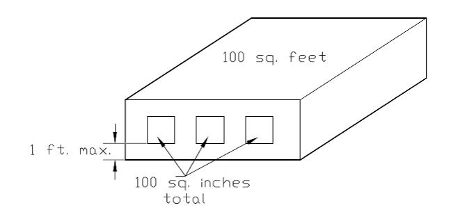
(2)
The bottom of all openings shall be no higher than 1 foot above grade.
(3)
Openings may be equipped with screens, louvers, valves, or other coverings or devices provided that they permit the automatic entry and exit of floodwaters.
(P)
The placement of recreational vehicles (RV) in special flood hazard areas must either:
(1)
Be temporary, as demonstrated by the RV being fully licensed, being on wheels or a jacking system, attached to the site only by quick disconnect type utilities and security devices, having no permanently attached additions, and being immobile for no more than one hundred eighty (180) consecutive days; or else
(2)
Meet all provisions of this Code applicable to manufactured home structures.
(Q)
All proposals for the development of a residential subdivision, commercial business park or manufactured home park/subdivision must have public utilities and facilities such as sewer, gas, electrical and water systems located and constructed to minimize or eliminate flood damage.
(R)
All proposals for the development of a residential subdivision, commercial business park or a manufactured home park/subdivision must include an adequate drainage plan to reduce exposure to flood hazards.
(S)
All proposals for the development of a commercial business park or a manufactured home park/subdivision must include an adequate evacuation plan for the escape of citizens from affected nonresidential structures during flooding events.
(T)
Standards for Subdivisions: Applications for preliminary, final, and/or concurrent plat approval shall:
(1)
Identify the special flood hazards areas, including delineation of floodways and the elevation of the base flood.
(2)
All final plats shall provide the elevation of proposed structure(s) and pad(s). If the site is filled above the base flood, the final pad elevation shall be verified by a registered professional engineer, or surveyor, and provided to the Floodplain Administrator.
(3)
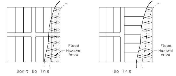
To the extent practicable, lot boundaries shall be made to coincide with natural and pre-existing man-made drainage ways within subdivisions to avoid the creation of lots that can be built upon in only by altering such drainage ways. (See illustration: Figure 3.)
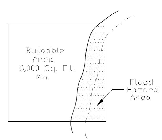
Any lot platted so that a portion of the lot lies in a special flood hazard area shall contain a minimum of 6,000 square feet of buildable area, including setbacks, outside the special flood hazard area, or if it contains less than 6,000 square feet of buildable area, it shall be platted to contain a minimum of 1 acre. Any lot platted so that the entire lot lies in a special flood hazard area shall contain a minimum of 1 acre. (See illustration: Figure 4.)
(4)
For subdivisions partially located in special flood hazard areas, minimum lot area requirements may be waived by the director to allow the platting of lots to be clustered outside the special flood hazard area, the density permitted for the zoning district to be averaged over the entire parcel, provided a permanent conservation easement is granted to the city, a land trust, or the property owners association to ensure that the area of special flood hazard will remain undeveloped.
(5)
In all areas designated as a Zone A on the FIRM where a detailed study has not been completed to specify the floodway and base flood elevations, no development shall be located within the Zone A area.
(a)
Provided, the applicant may choose, if not required by other provisions of this chapter, to provide a detailed hydrologic and hydraulic study which delineates the floodway, one hundred (100) year floodplain boundary, and base flood elevations. At such time as a study is approved by FEMA, the applicant shall meet all requirements for areas designated with floodway, one hundred (100) year floodplain, and base flood elevations.
(b)
If, for some reason, the property owner believes the FIRM to be inaccurate, a letter of map amendment may be submitted to FEMA by the applicant. If the boundaries of the floodplain are approved and amended by FEMA, setbacks will be enforced pursuant to the amendment.
(U)
Any new construction, addition or other development may be approved in a special flood hazard area only if:
(1)
The applicant has provided a detailed hydrologic and hydraulic study performed by a professional engineer licensed in the state of Arkansas which delineates the floodway, 1% annual chance (100-year) floodplain boundary, and base flood elevations and demonstrates through a hydrologic and hydraulic analysis, that the development will not increase flood flows (0.0 cubic feet per second), flood heights (0.00 feet) or flood channel velocities (0.0 feet per second) on the subject property or any property upstream or downstream, and
(2)
The proposed development does not increase flood damage to off-site properties during the occurrence of the regulatory flood (1% annual chance/100-year) or any flood of more frequent occurrence, and
(3)
The proposed development provides compensatory storage for any measurable loss of flood storage capacity.
(4)
Provided that this shall not apply for a single accessory structure per lot placed on existing grade (no proposed fill material), without a foundation and no larger than 150 square feet, including storage sheds, playground equipment, gazebos, etc., that is not located within a regulatory floodway and constructed in compliance with the remainder of this Code.
(V)
Any structure, including but not limited to new structures, additions and substantial improvement, constructed on property fully or partially within the special flood hazard area (SFHA) shall meet the elevation or floodproofing requirements within §168.11 as applicable, even if the structure itself is located outside the SFHA.
(Ord. No. 5141, 5-6-08; Ord. No. 6446, §10(Exh. E), 6-15-21; Ord. No. 6539, §§9—11, 3-1-22)
168.11 - Risk Zone Specific Standards
In addition to the general standards, the following standards apply to specific development types in specific Risk Zones, except as revised in Section E of this article. Risk Zones listed in this Code that do not appear on the current FIRM are not applicable.
(A)
In AE Risk Zones: special flood hazard areas with base floods determined:
(1)
For residential structures in Zone AE:
(a)
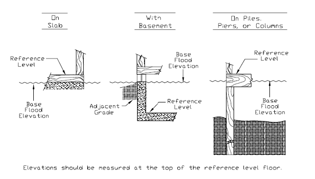
For all new residential structures, the top surface of the lowest floor and any mechanical equipment must have an elevation 2 feet or more above the published BFE. This elevation must be documented on an elevation certificate properly completed by a professional engineer, surveyor or architect licensed to practice in the State of Arkansas.
(b)
For all substantial improvements or substantial damage to existing residential structures, the entire structure becomes subject to the requirements of a new residential structure.
(c)
For any reconstruction, rehabilitation, addition, or other improvement to an existing residential structure that is less than a substantial improvement, only the improved area, but not the entire structure, becomes subject to the requirements of a new residential structure.
(2)
For nonresidential structures in Zone AE:
(a)
All new commercial, industrial or other nonresidential structures must either:
(i)
Have the lowest floor (including basement) and any mechanical equipment elevated 2 feet or more above the base flood level; or
(ii)
Be floodproofed such that, together with attendant utility, sanitary facilities and mechanical equipment, be designed so that below an elevation of 3 feet above the base flood level the structure is watertight with walls substantially impermeable to the passage of water and with structural components having the capability of resisting hydrostatic and hydrodynamic loads and effects of buoyancy.
(iii)
A registered professional engineer or architect shall develop and/or review structural design, specifications, and plans for the construction, and shall certify on a floodproofing certificate that the design and methods of construction are in accordance with accepted standards of practice as outlined in this subsection. A record of such certification which includes the specific elevation (in relation to mean sea level) to which such structures are floodproofed shall be maintained by the Floodplain Administrator.
(b)
For all substantial improvements or substantial damage to existing commercial, industrial or other nonresidential structures the entire structure becomes subject to the requirements of a new nonresidential structure.
(c)
For any reconstruction, rehabilitation, addition, or other improvement to an existing nonresidential structure that is less than a substantial improvement, only the improved area, but not the entire structure, becomes subject to the requirements of a new nonresidential structure.
(3)
For manufactured homes in Zone AE:
(a)
All manufactured homes that are placed or substantially improved on sites:
(i)
Outside of a manufactured home park or subdivision;
(ii)
In a new manufactured home park or subdivision;
(iii)
In an expansion to an existing manufactured home park or subdivision; or
(iv)
In an existing manufactured home park or subdivision on which a manufactured home has incurred "substantial damage" as a result of a flood, be elevated on a permanent foundation such that the lowest floor of the manufactured home is elevated 2 feet or more above the base flood elevation and be securely anchored to an adequately anchored foundation system to resist flotation, collapse, and lateral movement.
(b)
Require that manufactured homes be placed or substantially improved on sites in an existing manufactured home park or subdivision on the community's FIRM that are not subject to the provisions of §168.11(A)(3)(a) of this section be elevated so that either:
(i)
The lowest floor of the manufactured home and any mechanical equipment is 2 feet or more above the base flood elevation; or
(ii)
The manufactured home chassis is supported by reinforced piers or other foundation elements of at least equivalent strength that are no less than 36 inches in height above grade and be securely anchored to an adequately anchored foundation system to resist flotation, collapse, and lateral movement.
(iii)
For all substantial improvements or substantial damage to existing manufactured home, the entire structure becomes subject to the requirements of a new manufactured home.
(iv)
For any reconstruction, rehabilitation, addition, or other improvement to an existing manufactured home that is less than a substantial improvement, only the improved area, but not the entire structure, becomes subject to the requirements of a new manufactured home.
(c)
Where FEMA has not established a regulatory floodway in Zone AE, no floodplain development permit may be issued unless a detailed engineering analysis is submitted along with the application that demonstrates the increase in base floodwater elevation due to the proposed development and all cumulative developments since the publication of the current FIRM will be less than 1 foot.
(B)
Floodways — High risk areas of stream channel and adjacent floodplain:
(1)
Developments in regulatory floodways are prohibited, unless:
(a)
A no-rise certificate, signed and stamped by a professional engineer licensed to practice in the State of Arkansas, is submitted to demonstrate through hydrologic and hydraulic analyses performed in accordance with standard engineering practice that the proposed development would not result in any increase in flood levels within the community during the occurrence of a base flood event; or
(b)
All requirements of 44 CFR § 65.12 are first met.
(2)
No manufactured home may be placed in a regulatory floodway, regardless of elevation height, anchoring methods, or no-rise certification.
(C)
In AH or AO Risk Zones — Special flood hazard areas of shallow flooding:
(1)
For residential structures in Zones AH or AO:
(a)
All new residential structures must be constructed with the top surface of the lowest floor and any mechanical equipment elevated 2 feet or more above the published BFE, or 2 feet above the highest adjacent grade in addition to the depth number specified (at least 2 feet if no depth number is specified) on the community's FIRM. This elevation must be documented on an elevation certificate properly completed by a professional engineer, surveyor or architect licensed to practice in the State of Arkansas.
(b)
For all substantial improvements or substantial damage to existing residential structures the entire structure becomes subject to the requirements of a new residential structure.
(c)
For any reconstruction, rehabilitation, addition, or other improvement to an existing residential structure that is less than a substantial improvement, only the improved area, but not the entire structure, becomes subject to the requirements of a new residential structure.
(2)
For nonresidential structures in Zones AH or AO:
(a)
All new commercial, industrial or other nonresidential structure must either:
(i)
Have the top surface of the lowest floor and any mechanical equipment elevated 2 feet or more above the published BFE, or 2 feet or more above the highest adjacent grade in addition to the depth number specified (at least 2 feet if no depth number is specified) on the community's FIRM, with documentation on an elevation certificate properly completed by a professional engineer, surveyor or architect licensed to practice in the State of Arkansas; or
(ii)
Be floodproofed such that the structure, together with attendant utility, sanitary facilities and mechanical equipment be designed so that below 3 feet or more above the published BFE in Zone AH, or 3 feet or more above the base specified flood depth in an AO Zone, the structure is watertight with walls substantially impermeable to the passage of water and with structural components having the capability of resisting hydrostatic and hydrodynamic loads of effects of buoyancy.
(b)
For all substantial improvements or substantial damage to existing commercial, industrial or other nonresidential structures the entire structure becomes subject to the requirements of a new nonresidential structure.
(c)
For any reconstruction, rehabilitation, addition, or other improvement to an existing nonresidential structure that is less than a substantial improvement, only the improved area, but not the entire structure, becomes subject to the requirements of a new nonresidential structure.
(3)
For manufactured homes in Zones AH or AO:
(a)
All manufactured homes that are placed or substantially improved on sites:
(i)
Outside of a manufactured home park or subdivision;
(ii)
In a new manufactured home park or subdivision,
(iii)
In an expansion to an existing manufactured home park or subdivision; or
(iv)
In an existing manufactured home park or subdivision on which a manufactured home has incurred "substantial damage" as a result of a flood, be elevated on a permanent foundation along with any mechanical equipment such that the lowest floor of the manufactured home is elevated 2 feet or more above the published BFE, or 2 feet or more above the highest adjacent grade in addition to the depth number specified (at least 2 feet if no depth number is specified) on the community's FIRM, and be securely anchored to an adequately anchored foundation system to resist flotation, collapse, and lateral movement.
(b)
Require that manufactured homes be placed or substantially improved on sites in an existing manufactured home park or subdivision on the community's FIRM that are not subject to the provisions of §168.11(C)(3)(a) of this section be elevated so that either:
(i)
The lowest floor of the manufactured home meets the elevation standard of §168.11(C)(3)(a)(iv); or
(ii)
The manufactured home chassis is supported by reinforced piers or other foundation elements of at least equivalent strength that are no less than 36 inches in height above grade and be securely anchored to an adequately anchored foundation system to resist flotation, collapse, and lateral movement.
(c)
For all substantial improvements or substantial damage to existing manufactured home, the entire structure becomes subject to the requirements of a new manufactured home.
(d)
For any reconstruction, rehabilitation, addition, or other improvement to an existing manufactured home that is less than a substantial improvement, only the improved area, but not the entire structure, becomes subject to the requirements of a new manufactured home.
(4)
Where FEMA has not established a regulatory floodway in Zones AH or AO, no floodplain development permit may be issued unless a detailed engineering analysis is submitted along with the application that demonstrates the increase in base floodwater elevation due to the proposed development and all cumulative developments since the publication of the current FIRM will be less than 1 foot.
(5)
Require adequate drainage paths around structures on slopes, to guide flood waters around and away from proposed structures.
(D)
In "A" Risk Zones — Special flood hazard areas with no base flood elevations determined:
(1)
In Zone A, the applicant or the applicant's agent must determine a base flood elevation prior to construction. The BFE will be based on a source or method approved by the local Floodplain Administrator.
(2)
For residential structures in Zone A:
(a)
For all new residential structures, the top surface of the lowest floor and any mechanical equipment must have an elevation 2 feet or more above the BFE. This elevation must be documented on an Elevation Certificate properly completed by a professional engineer, surveyor or architect licensed to practice in the State of Arkansas.
(b)
For all substantial improvements or substantial damage to existing residential structures, the entire structure becomes subject to the requirements of a new residential structure.
(c)
For any reconstruction, rehabilitation, addition, or other improvement to an existing residential structure that is less than a substantial improvement, only the improved area, but not the entire structure, becomes subject to the requirements of a new residential structure.
(3)
For nonresidential structures in Zone A:
(a)
All new commercial, industrial or other nonresidential structures must either:
(i)
Have the lowest floor (including basement) and any mechanical equipment elevated 2 feet or more above the base flood level; or
(ii)
Be floodproofed such that, together with attendant utility, sanitary facilities and mechanical equipment, be designed so that below an elevation of 3 feet above the base flood level the structure is watertight with walls substantially impermeable to the passage of water and with structural components having the capability of resisting hydrostatic and hydrodynamic loads and effects of buoyancy.
(iii)
A registered professional engineer or architect shall develop and/or review structural design, specifications, and plans for the construction, and shall certify on a floodproofing certificate that the design and methods of construction are in accordance with accepted standards of practice as outlined in this subsection. A record of such certification which includes the specific elevation (in relation to mean sea level) to which such structures are floodproofed shall be maintained by the Floodplain Administrator.
(b)
For all substantial improvements or substantial damage to existing commercial, industrial or other nonresidential structures the entire structure becomes subject to the requirements of a new nonresidential structure.
(c)
For any reconstruction, rehabilitation, addition, or other improvement to an existing nonresidential structure that is less than a substantial improvement, only the improved area, but not the entire structure, becomes subject to the requirements of a new nonresidential structure.
(4)
For manufactured homes in Zone A:
(a)
All manufactured homes that are placed or substantially improved on sites:
(i)
Outside of a manufactured home park or subdivision;
(ii)
In a new manufactured home park or subdivision;
(iii)
In an expansion to an existing manufactured home park or subdivision; or
(iv)
In an existing manufactured home park or subdivision on which a manufactured home has incurred "substantial damage" as a result of a flood, be elevated on a permanent foundation such that the lowest floor of the manufactured home and any mechanical equipment is elevated 2 feet or more above the base flood elevation and be securely anchored to an adequately anchored foundation system to resist flotation, collapse, and lateral movement.
(b)
Require that manufactured homes be placed or substantially improved on sites in an existing manufactured home park or subdivision on the community's FIRM that are not subject to the provisions of §168.11(D)(4)(a) of this section be elevated so that either:
(i)
The lowest floor of the manufactured home is 2 feet or more above the base flood elevation; or
(ii)
The manufactured home chassis is supported by reinforced piers or other foundation elements of at least equivalent strength that are no less than 36 inches in height above grade and be securely anchored to an adequately anchored foundation system to resist flotation, collapse, and lateral movement.
(c)
For all substantial improvements or substantial damage to existing manufactured home, the entire structure becomes subject to the requirements of a new manufactured home.
(d)
For any reconstruction, rehabilitation, addition, or other improvement to an existing manufactured home that is less than a substantial improvement, only the improved area, but not the entire structure, becomes subject to the requirements of a new manufactured home.
(5)
Base flood elevation data and a regulatory floodway, utilizing accepted engineering practices, shall be generated for subdivision proposals and other proposed development including the placement of manufactured home parks and subdivisions which is greater than fifty (50) lots or 5 acres, whichever is lesser, if not otherwise provided.
(Ord. No. 5141, 5-6-08; Ord. No. 6446, §10(Exh. E), 6-15-21)
168.12 - Streamside Protection Zones
(A)
Streamside Best Management Practices Manual. The City of Fayetteville's Streamside Best Management Practices Manual, which may be administratively changed by the City Engineer, shall be used in support of this chapter to explain specific objectives and principles.
(B)
Applicability. This ordinance shall apply to all land within the streamside protection zones.
(C)
Establishment of Designated Surface Waters. The streamside protection zones shall apply to all surface waters meeting any one of the following criteria:
(1)
All surface waters identified on the adopted Protected Streams Map (which may be administratively amended by the City Engineer to reflect applicable surface waters within annexed areas), including any pond, lake or reservoir located within the natural drainage way of said surface water; or
(2)
Any surface water where a floodway has been established by the Federal Emergency Management Agency (FEMA).
(3)
Surface waters that would have otherwise been protected, but were outside the City Limits when Ordinance No. 5390 was adopted on March 1, 2011, shall be automatically included as designated surface waters within the requirements of §168.12, Streamside Protection Zones, upon the annexation into Fayetteville of the property on which the surface waters are located.
(D)
Streamside Protection Requirements. The streamside protection zones shall be established as follows:
(1)
Zone 1: Waterside Zone. The waterside zone shall extend a minimum of 25 feet landward from the top of bank in each direction, measured horizontally on a line perpendicular to the top of bank and includes the surface water.
(a)
Steep Slope. Slope shall be calculated at the upstream and downstream property lines for every property. Properties with more than 100 feet of stream frontage shall require additional slope calculations at 100-foot increments, beginning at the upstream property line and ending at the downstream property line. When slope calculations are equal to or greater than 15%, the width of the waterside zone shall be extended by an additional 20 feet at that point. The boundary width determined at each designated slope measurement point shall be connected by a continuous line to form the boundary of the waterside zone (illustrations available in the Best Management Practices Manual).
(2)
Zone 2: Management Zone. The management zone shall begin at the outer edge of the Waterside Zone and extend landward 25 feet as measured horizontally on a line perpendicular to Zone 1. The combined width of Zones 1 and 2 shall be no less than 50 feet from the top of bank on all sides of the surface water.
(a)
Floodway. Where the floodway extends beyond the edge of the management zone boundary, said boundary shall be adjusted so that the zone consists of the extent of the floodway as designated by the most recently adopted FEMA Flood Insurance Rate Map (FIRM).
(3)
Piped Streams. When reviewing any development, grading or building permit application, the City Engineer may determine that normal streamside protection regulations shall not be applicable to that portion of a stream that has been piped or enclosed within a culvert or similar conduit prior to the adoption of this ordinance.
(4)
Daylighting. Streams enclosed prior to the effective date of this ordinance and subsequently daylighted shall only require a 5-foot setback measured from the established top of bank. Daylighted streams shall be maintained in a natural state by the property owner, who shall also be responsible for monitoring and controlling trash, litter and pollutants.
(E)
Regulated Uses, Structures and Activities Within the Streamside Protection Zones.
(1)
The following are permitted within the designated streamside zone, subject to the requirements of this section, the Flood Damage Prevention Code, and all applicable requirements of the City of Fayetteville. Where a use is not listed, but is similar to a permitted use and is in keeping with the purpose of the streamside protection zones, the City Engineer may determine the use to be allowed. All other uses shall be prohibited.
(a)
Zone 1: Waterside Zone. The following may be permitted in the waterside zone, provided the standards of the Streamside Best Management Practices Manual shall be followed where applicable and that these uses and any necessary construction is designed and built to minimize the impact upon streamside areas and minimize any excavation or filling that will only be allowed by express authorization of the City Engineer. All construction, grading, excavation or filling must also fully comply with all necessary local, state and federal permits.
(i)
Open space uses that are primarily passive in character including: preserves, fishing areas and docks, parkland, and natural trails.
(ii)
Streambank restoration or stabilization.
(iii)
Water quality monitoring, education and scientific studies.
(iv)
Revegetation and reforestation.
(v)
Dam maintenance.
(vi)
Paved trails or other impervious surfaces not exceeding 12 feet in width when the City Engineer determines that there is no practical and feasible alternative. Such area may not be used to park vehicles.
(vii)
Stream crossings, including driveways, roadways, trails, or railroads when the City Engineer determines there is no practical and feasible alternative.
(viii)
Maintenance and upgrades of existing utility facilities.
(ix)
New utility facilities when the City Engineer determines there is no practical and feasible alternative.
(x)
Management of lawns and gardens.
(xi)
Removal of dead vegetation, pruning for reasons of public safety, removal of invasive species.
(xii)
Application of any fertilizer, herbicide, pesticide, or insecticide shall be allowed only if their harmful effect on water quality is prevented by ensuring no over-application or misapplication occurs.
(xiii)
Maintenance of drainage capacity in the channel including tree and sediment removal.
(xiv)
New stormwater conveyances when the City Engineer determines that there is no practical and feasible alternative.
(b)
Zone 2: Management Zone.
(i)
New stormwater conveyances when the City Engineer determines that there is no practical and feasible alternative and provided the standards of the Streamside Best Management Practices Manual shall be followed.
(ii)
All uses within the waterside zone with the exception of stormwater conveyances, provided that compliance with the standards of the Streamside Best Management Practices Manual are not required but encouraged.
(iii)
Accessory structures without a foundation and no larger than 150 square feet, including storage sheds, playground equipment, gazebos, decks, etc.
(iv)
Active recreational uses.
(2)
Establishment of the following uses/activities after the effective date of this ordinance shall be prohibited in both streamside protection zones, except where necessary to allow an activity permitted by subsection (E)(1).
(a)
Grading, dredging, dumping, filling, or similar construction activities.
(b)
Landfills, junkyards, salvage yards.
(c)
Clearing of non-invasive woody vegetation.
(d)
Storage of hazardous materials or chemicals unless within waterproof containers and within a structure.
(e)
Parking lots.
(f)
Buildings and accessory structures with a building footprint larger than 150 square feet.
(g)
Parking or storage of motor vehicles.
(h)
Septic systems and/or lateral lines.
(i)
In-ground pools.
(j)
Animal feedlots or kennels.
(k)
Housing, grazing or other maintenance of livestock.
(l)
Land application of biosolids.
(F)
Existing Land Use Exemptions. The following activities and structures are allowed to continue within the streamside protection zones, provided that the provisions of the Flood Damage Prevention Code and all other applicable regulations shall be enforced.
(1)
Existing Uses. Existing uses shall be permitted to continue in their present state, but may not be enlarged, extended, or moved within the streamside protection zones. A use or activity shall be existing if it is present and ongoing within the streamside protection zones as of the effective date of this ordinance or the effective date of annexation for areas outside the city limits when Ordinance No. 5390 was adopted on March 1, 2011. Uses and activities cease to be existing under the following conditions:
(a)
Agricultural and Animal Husbandry Activities. The activities cease to be existing when the area on which they were conducted has been converted to a nonagricultural use or has lain idle for more than eighteen (18) consecutive months.
(b)
All Other Uses. This ordinance shall apply when an existing use is converted to another use.
(2)
Existing Principal Structures.
(a)
Reconstruction Within Existing Footprint. Existing principal structures as of the effective date of this ordinance may be redeveloped or reconstructed within the same footprint.
(b)
Minor Alterations. Minor alterations or additions to an existing structure, such as an awning or deck, shall also be permitted, provided the modifications do not extend more than 10 feet further toward the surface water than the original foundation of the principal structure, and do not extend into the waterside zone.
(c)
Berm to Prevent Flooding. If a principal structure has suffered flooding from a stream, the owner may construct a berm to protect the principal structure if approved by the City Engineer as to the berm's location, size and composition. Revegetation of the disturbed area and berm shall be in accordance with the Best Management Practices Manual.
(3)
Emergencies. Actions taken under emergency conditions, either to prevent imminent harm or danger to persons, or to protect property from imminent danger of fire, violent storms, or other hazards.
(G)
Development Application Procedures.
(1)
All persons required to submit an application pursuant to Chapter 166 of the city's Unified Development Code shall also show the location and type of surface water, the top of bank, Zone 1: Waterside Zone and Zone 2: Management Zone boundaries, and slope, when any portion of the property being developed falls within the streamside protection zones. The same shall also be identified for building, moving, demolition and grading permits.
(2)
An applicant may request that the city's Floodplain Administrator perform a site visit to view conditions on site with the applicant to assist in making a determination of top of bank location and widths of the waterside zone and management zone.
(3)
A final determination of any boundary shall be made by the City Engineer or designated representative, where there is question as to its location or width.
(H)
Streamside Protection Measures and Construction.
(1)
Prior to any land clearing or soil disturbing activity, the streamside protection zone boundaries shall be clearly delineated on site by the applicant, and such delineation shall be maintained throughout construction activities.
(2)
A site inspection followed by periodic inspections during construction will be conducted by the City Engineer or designated representative to ensure compliance with the streamside protection zone ordinance.
(3)
Streamside protection zones shall be protected from construction activity except where necessary to allow an activity permitted by subsection (E)(1). To prevent impacts, construction vehicle access is prohibited in the streamside protection zones except at permitted crossings. Storage of construction vehicles, materials, debris, spoils or equipment is prohibited in the streamside protection zones. Before commencing any construction activity, the applicant shall install silt fencing on the site at the outer edge of the management zone or as directed by the City Engineer. The City Engineer may require other protective measures based upon the individual characteristics of the site and the proposed construction methods. If the required barriers surrounding the streamside protection zones are not adequately maintained during construction, the City Engineer shall prescribe remedial measures, and may issue a stop work order in accordance with §153.07. All remedial measures shall be completed within the specified amount of time and shall be considered prior to granting final plat approval or issuing a certificate of occupancy.
(Ord. No. 5390, 3-1-11; Ord. No. 6410 §§1, 2, 2-2-21; Ord. No. 6446, §10(Exh. E), 6-15-21)
168.13 - Enforcement
(A)
Flood hazards are reduced by compliance with the provisions of this Code. Accordingly, enforcement of this ordinance discourages non-compliance and is a recognized mechanism for flood hazard reduction.
(B)
The Floodplain Administrator must enforce the provisions of this ordinance and is authorized to:
(1)
Issue stop work orders on non-compliant floodplain development projects;
(2)
Request that FEMA file a 1316 Action (Denial of Flood Insurance) against non-compliant properties; and
(3)
Take any other lawful action necessary to prevent or remedy any instance of non-compliance with the provisions of this ordinance.
(C)
It is hereby declared to be a misdemeanor to violate or fail to comply with any provision of this ordinance.
(D)
Any person found guilty in the District Court of violating this ordinance is subject to the penalties set forth at §10.99 of the Fayetteville Code of Ordinances.
(Ord. No. 5141, 5-6-08)