
Flowery Branch City Zoning Code
ARTICLE 10
- DEVELOPMENT REQUIREMENTS AND GUIDELINES8
Editor's note— Ord. No. 3148-17, adopted Aug. 2, 2018, repealed and reenacted Article 10 in its entirety. Former Art. 10, §§ 10.1—10.20 pertained to similar subject matter and derived from the zoning ordinance adopted Dec. 13, 2006 and Ord. No. 348-11, §§ 13—15, adopted Nov. 18, 2010.
Sec. 10.1.- Applicability.
(a)
The development requirements and guidelines are intended to apply to all land uses unless the context clearly indicates otherwise as specifically provided in this Article, and with the exception that Sec. 10.7. - Architectural Design, Sec. 10.8, - Pedestrian Retail and Sec. 10.10. - Office, Institutional, Business, and Industrial Parks and Campuses do not apply to townhouses, single-family detached dwellings, and duplexes.
(b)
See Article 12, Sec. 12.6, Sec. 12.7, and 12.8 in this Zoning Ordinance for additional requirements that pertain to townhouses, single-family detached dwellings, and duplexes.
(c)
See also Article 40. Design Review.
(Ord. No. 348-17, § 1(Exh. A), 8-2-2018; Ord. No. 657, § 1(Exh. A), 12-16-2021)
Sec. 10.2. - Interpretation.
Flexibility toward compliance with these regulations may be given if it is determined by the Zoning Administrator that the spirit and intent of the regulation is being followed.
(Ord. No. 348-17, § 1(Exh. A), 8-2-2018)
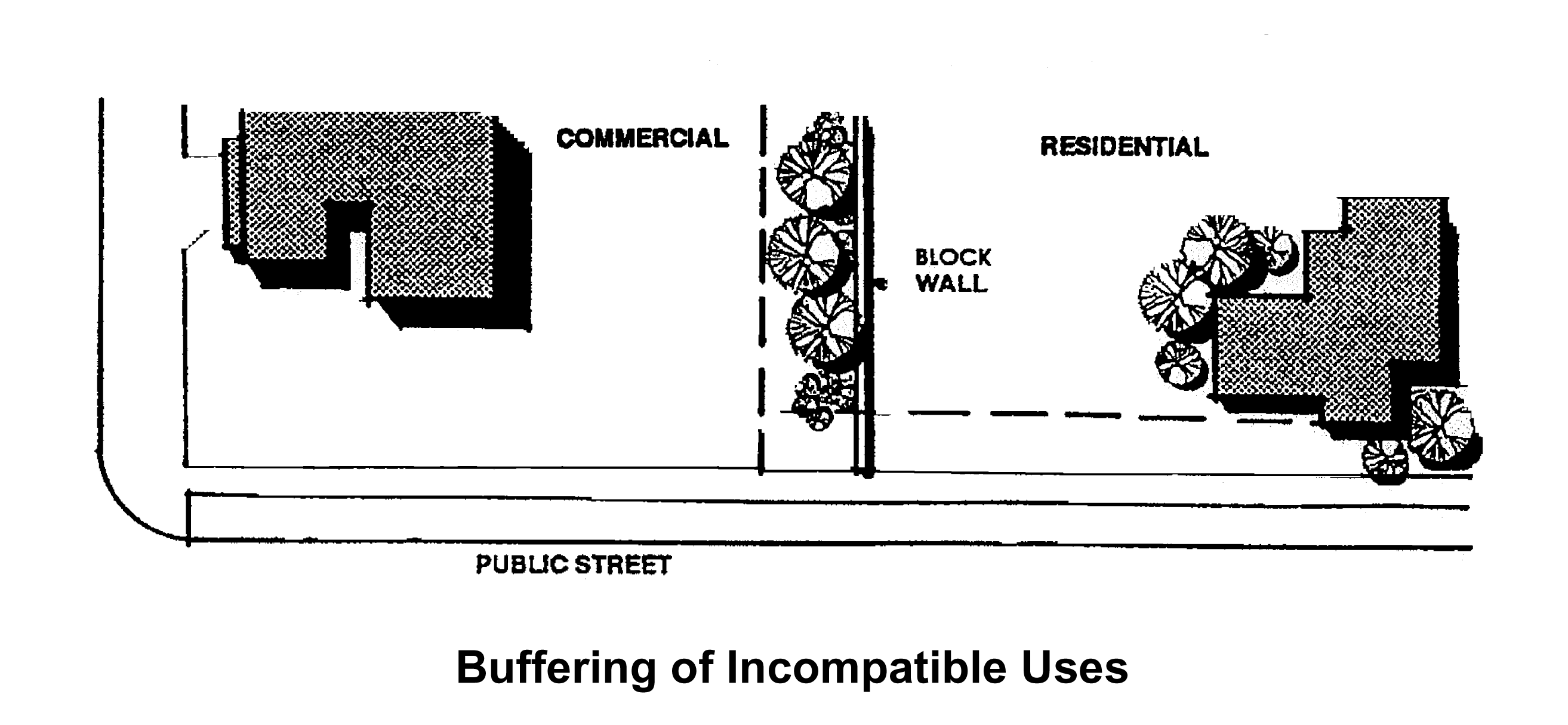
Sec. 10.3. - General Compatibility.
(a)
The site plan, building design, and landscaping of new development should achieve high quality and appearance which will enhance and be compatible with the character of the surrounding area.
(b)
Site planning and design of projects proposed adjacent to dissimilar land uses should carefully address the potential undesirable impacts on existing uses. These impacts may include traffic, parking, circulation and safety issues, light and glare, noise, odors, dust control and security concerns.
_____
(Ord. No. 348-17, § 1(Exh. A), 8-2-2018)
_____
Sec. 10.4. - Environmental Compatibility.
(a)
Evaluate the proposed development's compatibility with the existing environment to determine the limitations and capabilities of the site for development. Conserve and protect natural resources, including air quality, trees, natural vegetation, existing topography, streams, creeks, wetlands, watersheds, water quality, and wildlife habitat. Development should be limited to a level that does not exceed the capabilities and requirements of a healthy environment.
(b)
Significant site features such as habitats, natural ground forms, existing site vegetation, large rock outcroppings, water, and significant view corridors should be identified and incorporated into development plans. Where possible, a diversity of habitats is preferred.
(c)
Riparian zones, stream corridors, and wetlands should be protected for their wildlife habitat and other values. Development plans for these areas should treat these components as assets. A continuous, connected, natural vegetative corridor should be preserved along all creek and stream corridors to provide stream quality protection and for the efficient movement of wildlife throughout the area. No fill, removal, or modification of a riparian area should take place, unless there is no reasonable and feasible alternative. The alteration or improvement of significant natural resource areas where permitted, should ensure that potential losses are mitigated and best management practices are employed to minimize permanent damage.
(d)
Existing vegetation should be retained to the maximum extent possible. Clearing of native vegetation should be limited to that required for the provision of essential purposes (i.e., access, building, sewage disposal, etc.). Where appropriate, existing native vegetation should be enhanced with plantings of the same variety.
(e)
Preserve patches of high-quality habitat, as large and circular as possible, feathered at the edges, and connected by wildlife corridors.
(Ord. No. 348-17, § 1(Exh. A), 8-2-2018)
Sec. 10.5. - Grading.
(a)
Developments should be designed to fit the existing contours and landform of the site and to minimize the amount of earthwork. Excavation and earthworks should be kept to a minimum to reduce visual impacts and erosion. Where cut and fill is required, balancing the cut and fill is highly encouraged.
(b)
Abrupt or unnatural-appearing grading is strongly discouraged. Avoid the creation of harsh, easily eroded banks and cuts.
(c)
The height and length of retaining walls should be minimized and screened with appropriate landscaping. Tall, smooth-faced concrete retaining walls should be avoided in highly visible areas. Terracing should be considered as an alternative to the use of tall or prominent retaining walls, particularly in highly visible areas on hillsides.
(d)
Disturbed areas which are not used for roads, buildings, or other auxiliary uses should be replanted.
(Ord. No. 348-17, § 1(Exh. A), 8-2-2018)
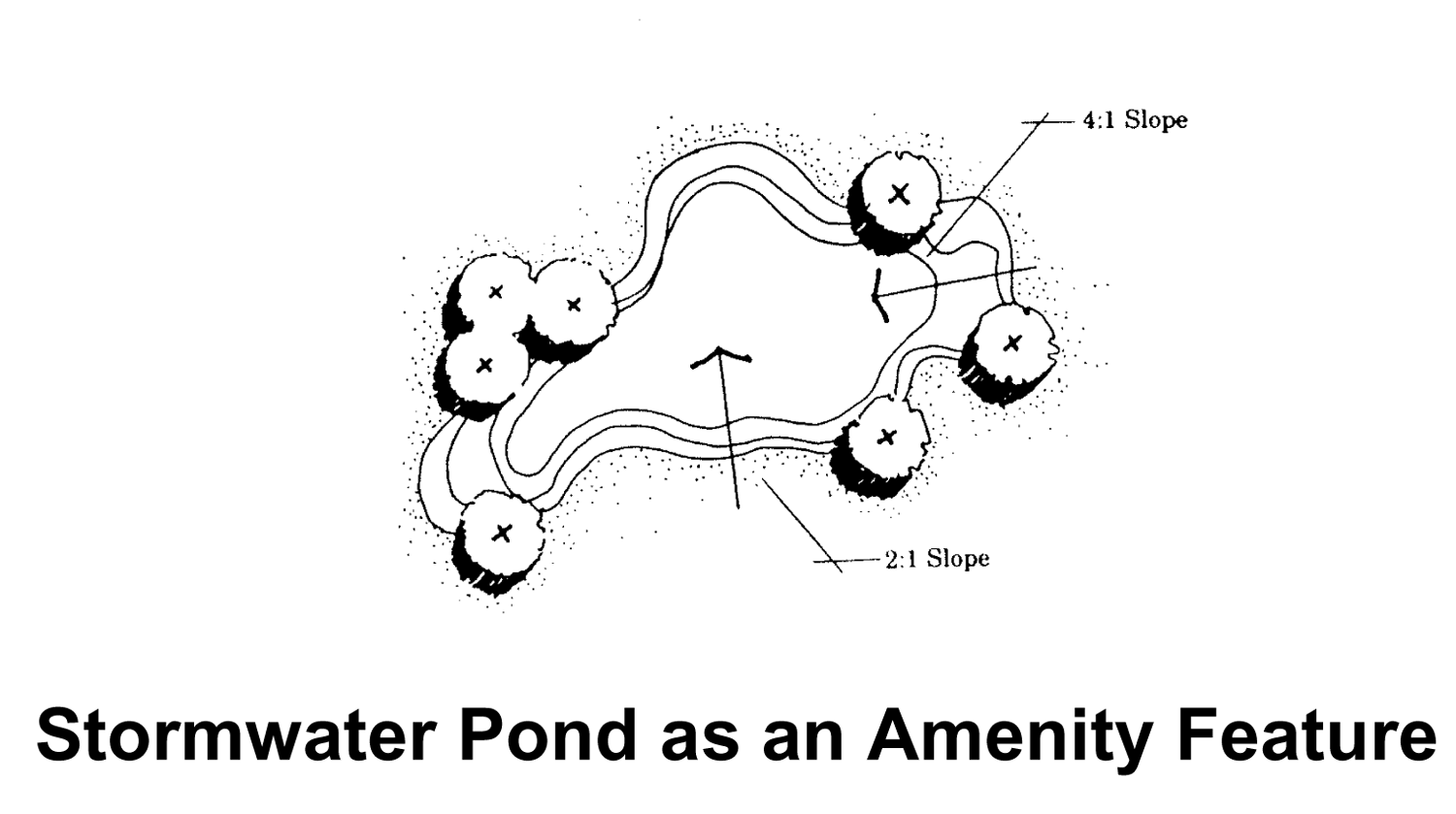
Sec. 10.6. - Drainage.
(a)
Natural on-site drainage patterns should be used where practicable. Detain runoff with open, natural drainage systems where possible.
(b)
Design man-made lakes and stormwater ponds for maximum habitat value and/or to serve as amenity features. Stormwater ponds and facilities that are visible from the public right-of-way shall be landscaped with a combination of densely planted shrubs and ground cover. Any fencing surrounding a stormwater pond that is visible from the public right-of-way shall be decorative in nature. (Ord. 348-11)
(Ord. No. 348-17, § 1(Exh. A), 8-2-2018)
Sec. 10.7. - Architectural Design.
(a)
Architectural design should be compatible with the developing character of the neighboring area. Design compatibility includes complementary building style, form, size, color, materials, and detailing. The designer should consider each of the following contexts as part of the design process:
1.
Size (the relationship of the project to its site).
2.
Scale (the relationship of the building to those around it).
3.
Massing (the relationship of the building's various parts to each other).
4.
Fenestration (the placement of windows and doors).
5.
Rhythm (the relationship of fenestration, recesses and projections).
6.
Setback (in relation to setback of immediate surroundings).
7.
Materials (their compatibility with the historic district).
8.
Context (the overall relationship of the project to its surroundings).
(b)
Efforts to coordinate the height of buildings and adjacent structures are encouraged. This is especially applicable where buildings are located very close to each other. It is often possible to adjust the height of a wall, cornice or parapet line to match that of an adjacent building. Similar design linkages such as window lines should be placed in a pattern that reflects the same elements on neighboring buildings.
(c)
Diversity of architectural design should be encouraged. "Theme" or stylized architecture which is characteristic of a particular historic period or trend is not encouraged, unless the existing building or site is historically important to the district or necessary for architectural harmony.
(d)
Multiple buildings on the same site shall be designed to create a cohesive visual relationship between the buildings.
(e)
Long or continuous wall planes shall be avoided, particularly in pedestrian activity areas, where buildings should exhibit more detail and elements appropriate for close range pedestrian view. Recesses and projections should be used along the front facade to break up long expanses of wall planes.
(f)
Façade articulation.
1.
Office, institutional, commercial, and industrial uses. The walls of buildings shall not extend more than 200 linear feet parallel to a street unless the front façade of the building is designed in a way that breaks up the building face into discrete architectural elements, which can be accomplished through the following:
Facade modulation: stepping back or extending forward a portion of the façade; and/or
Providing bay windows or repeating window patterns at regular intervals; and/or
Providing a porch, patio, deck, covered entry to portions of the façade at the ground level, or in the case of buildings containing two or more story, balconies; and/or
Changing the roofline by alternating dormers, or using stepped roofs, gables, or other roof elements; and/or
Changing materials with the change in building plane.
Consistent: Roof planes should be varied to increase visual interest, and awnings above windows and entrances also help to provide visual interest;
Inconsistent: Flat roofs and lengthy, non-articulated walls;
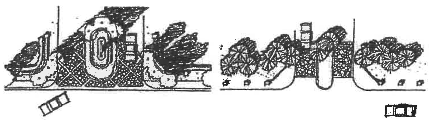
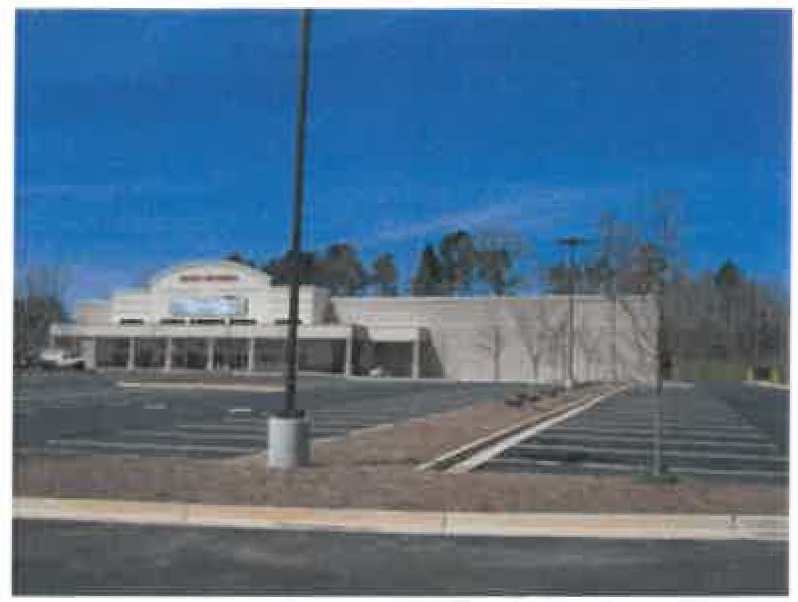
Consistent: A line of mature trees that almost entirely screens what would otherwise be a large, imposing side wall of a big box;
Inconsistent: The rear side of this shopping center consists of a finished but monotonous wall. Trash receptacles are not enclosed.
2.
Multi-family dwellings. Variation in the roofline of buildings and offsets in pitched roofs and gables is required. Facades over 50 feet in length must incorporate projections or recesses a minimum of 12 inches in depth. The combined length of said projections and recesses must constitute at least 20% of the total façade length. On street-facing façades of any building in a multi-family development, the blank wall area (defined as the portion of the exterior façade of a building that does not include windows or doors; pilasters or other articulation greater than 12 inches in depth; or a substantial change in material) shall not exceed 30 feet in either a vertical or horizontal direction. Transparency (defined as the minimum percentage of windows and doors that must cover a ground or upper story façade) on a street-facing façade of any building in a multi-family development shall be a minimum of 20% on each story.
(g)
Outside of pedestrian retail districts, building surfaces over two stories high or fifty feet in length shall be relieved with changes of wall plane (i.e., recesses and projections) that provide strong shadow or visual interest.
(h)
All sides of a building may impact on its surroundings and shall utilize an architectural finish of primary materials consisting of real brick (full-depth or thin brick), unpainted natural stone, unpainted cast stone, true three-coat cement stucco, natural wood or cementious siding including lap siding and board and batten, and wood or cementious shakes and shingles. Front façades shall be at least 50% real brick and/or unpainted natural stone. Side façades shall be at least 50% real brick and/or unpainted natural stone. Rear façades that are visible from a public right-of-way shall be at least 50% real brick and/or unpainted natural stone. Requirements for brick or stone may be modified to accommodate creatively designed structures as determined by the Community Development Director.
(i)
Exterior building materials on the primary structure shall not include smooth-faced concrete block, tilt-up concrete panels, or prefabricated steel panels, with the exception that exterior building materials on industrial buildings may be split face (integrated block) and/or tilt-up concrete panels accented with steel panels. However, elevations visible from the public right-of-way must be permanent, non-metal construction.
(j)
The following types of building materials shall not be used: highly reflective, shiny, or mirror-like materials; mill-finish (non-colored) aluminum metal windows or door frames; exposed, unfinished foundation walls; exposed plywood or particle board; and unplastered, exposed concrete masonry blocks.
(k)
Piecemeal embellishment and frequent changes in material shall be avoided. Material or color changes generally shall occur at a change of plane. A horizontal accent stripe (e.g., a foot wide stripe of different color) shall be used to help reduce the monotonous color and break up the appearance of large building walls, and shall be used when there is a change in exterior finish.
(l)
Facade colors shall be low reflectance, subtle, neutral, or earth tone colors. High-intensity colors, metallic colors, black, or fluorescent colors shall not be used. Building trim and accent areas on non-residential buildings may feature brighter colors, including primary colors, provided that the width of the trim shall not exceed four (4) feet.
(m)
Building colors should be carefully chosen so that each building complements that of its neighbors. Colors can be classified as the "base" color (used on the majority of the building surface), "trim" color (used on the window trim, fascia, balustrades, and posts), and "accent" color (used on signs, awnings, and doors). The base color shall consist of more subdued earth tones or brick shades. Trim colors shall have contrasting lighter or darker shade than the base color. If natural brick is used, it shall not be painted.
(n)
The use of awnings on buildings are recommended so as to provide much needed protection from sun, wind, and rain, and to improve aesthetics of the building exterior.
(o)
Awnings are recommended to be constructed with a durable frame covered by a canvas material. Awnings that are backlit through translucent materials may be acceptable but are not particularly encouraged. Aluminum and other metal canopies are acceptable in most instances, particularly when integrated into shopping center designs. Flameproof vinyl, canvas or metal awnings and canopies may be used.
(p)
Solid colors are preferred over striped awnings, but striping is permitted if colors compliment the character of the structure or group of buildings.
(q)
Awnings are encouraged for first floor retail uses to provide architectural interest and to encourage pedestrian activity. Where awnings are used, they should be designed to coordinate with the design of the building and any other awnings along the same block face.
(r)
The design of fences and walls shall be compatible with the architecture of the main building(s) and should use similar materials. All walls or fences fifty feet in length or longer, and four feet in height or taller, should be designed to minimize visual monotony though changes in plane, height, material or material texture or significant landscape massing. Chain link fencing is discouraged. Use of special fencing design or materials should be discussed in cases where site security is paramount. If used, chain link fences should be vinyl coated (black or green colored vinyl encouraged).
(s)
All commercial, industrial, large multi-family residential and institutional sites must provide appropriate refuse dumpsters and other similar areas devoted to the storage of waste materials and grease or oil containers. The minimum area for said requirement shall be 36 square feet. All garbage dumpsters and other similar areas devoted to the storage of waste materials and grease or oil containers should be screened on three (3) sides of said dumpster or area with a minimum six (6) foot high solid wooden fence, or a wall constructed of materials substantially similar in appearance to the building on site. In addition, said dumpster areas should be gated on the fourth side with a material that provides opaque screening, should be screened on three (3) sides of said dumpster or area with a minimum six (6) foot high solid wooden fence, or a wall constructed of materials substantially similar in appearance to the building on site. In addition, said dumpster areas should be gated on the fourth side with a material that provides opaque screening.
(t)
Rooftop mechanical and electrical equipment shall be screened from public view by building elements that are designed as an integral part of the building architecture, or by a parapet wall.
(u)
Where roof shingles are used, architectural shingles shall be required.
(Ord. No. 348-17, § 1(Exh. A), 8-2-2018; Ord. No. 657, § 1(Exh. A), 12-16-2021)
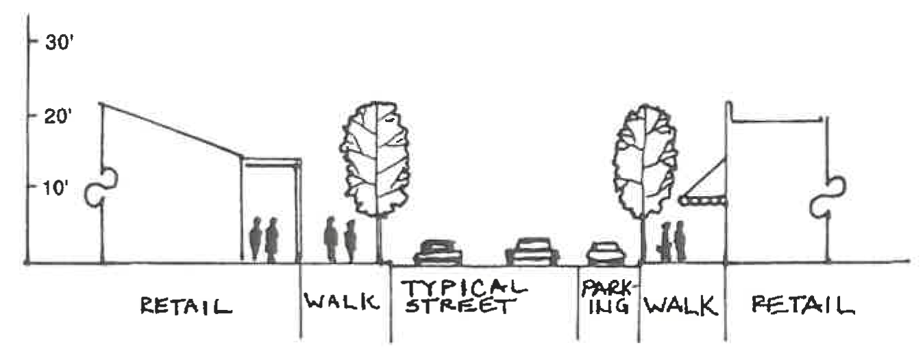
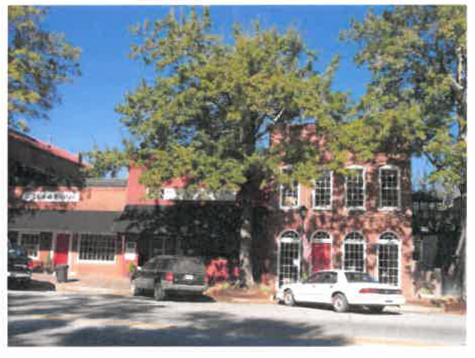
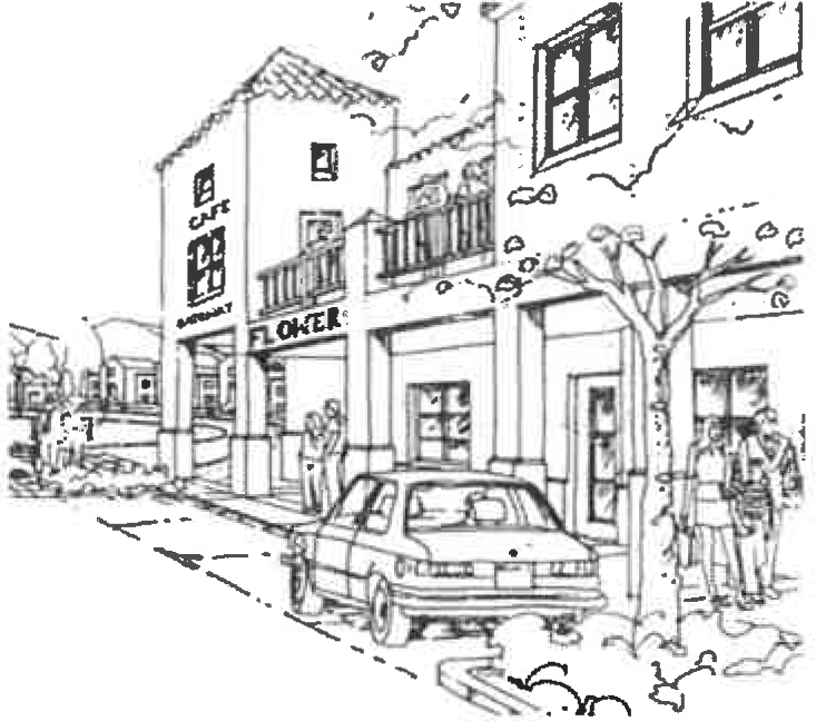
Sec. 10.8. - Pedestrian Retail.
(a)
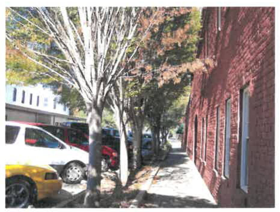
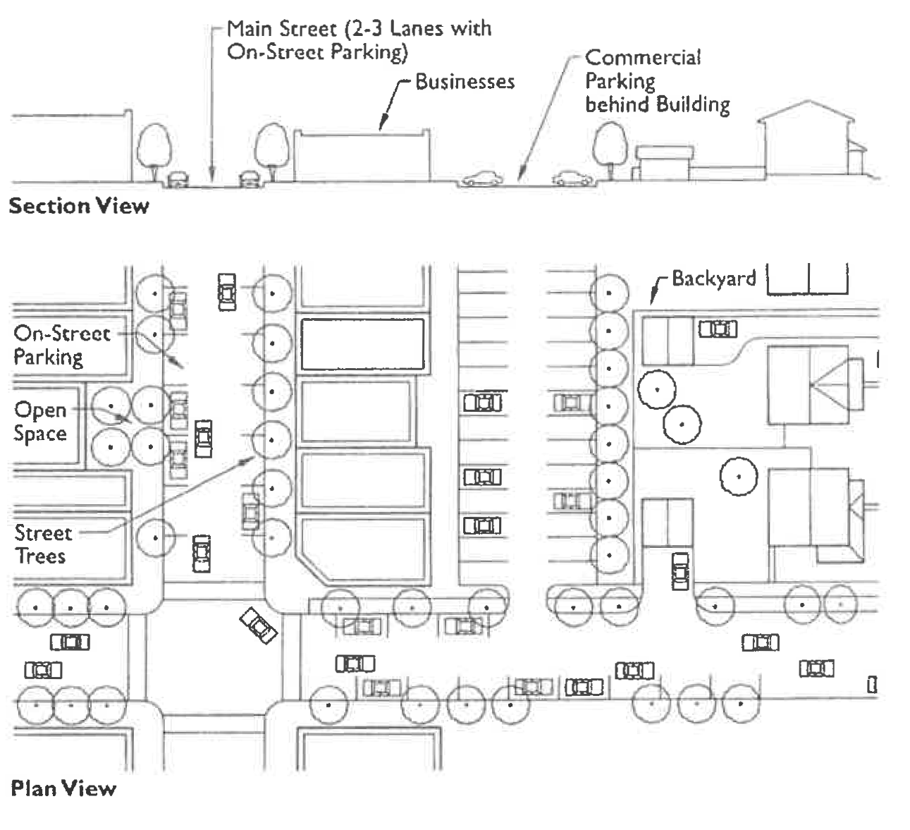
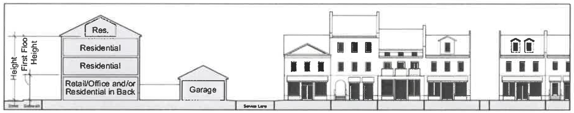
These areas of commerce are designed first and foremost with attention to the pedestrian rather than the automobile. Sidewalks are wide enough for significant pedestrian activity and auto and truck access is limited in areas of pedestrian activity. Buildings frame the street by being located close to the street and with a height of at least 1.5 stories. The buildings, many of which are retail shops, have awnings and storefront windows, that add interest to pedestrians. Signs are smaller and closer to the ground, rather than being sized and located to attract motorists.
Consistent: 1.5-story or taller building heights, canopies and awnings, wide sidewalks with street trees, on-street parking.
Source: Arendt, Randall, et al. Rural By Design: Maintaining Small Town Character, Figure 9-11, p. 126. (Chicago: Planners Press, 1994).
 |  |
| Consistent: Building frames the street. Sidewalk provided. Street tree planting strip in between on-street parking and the sidewalk. | Consistent: Store-front retail spaces have awnings and are located abutting a wide sidewalk. On-street parking and street trees. |
Source: Aaron Fortner, Market + Main, and Richard Dagenhart. Commercial Corridors, p. 418 in Planning and Urban Design Standards (New York: John Wiley & Sons, 2006).
(b)
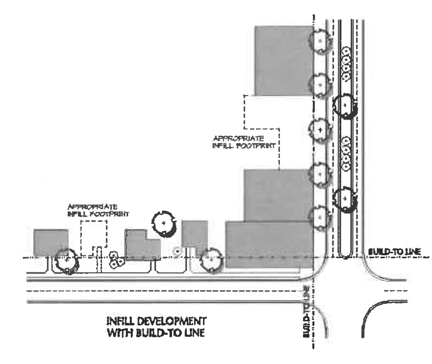
Building Placement. Buildings should be placed close to (with little if any setback from) streets internal to the development, or along public streets abutting the development area, as determined in the development review and approval process. The buildings should be generally placed so that the main entrance is oriented to the street sidewalk.
Source: Morris, Marya, ed. 1996. Creating Transit-Supportive Land Use Regulations. PAS Report No. 468. Figure 1-9, p. 10. Chicago: American Planning Association.
(c)
Building Lines. Buildings should observe the setbacks or "build-to" lines requirements established by buildings on either side of the proposed building.
(d)
Ground Floors. The ground level of multi-story buildings should contain retail or entertainment uses with direct entry from the street to provide pedestrian interest along sidewalks. Pedestrian interest can be enhanced with use of windows, entrances, and architectural details. Pedestrian signage, awnings, and ornamentation are encouraged.
(e)
Consistent: Storefront windows should be transparent. Mirrored glass, faux windows or display casements are strongly discouraged.
(f)
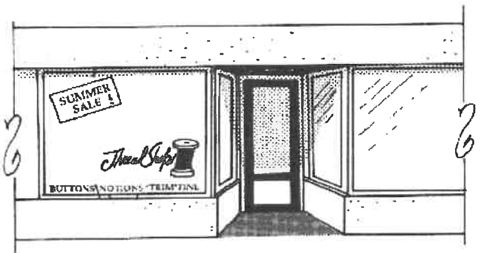
Storefront Windows. In designated shopfront areas, at least 75 percent of the building's front façade should consist of clear glass window and/or door. Windows should be at least ten feet (10') in height and no more than three feet (3') above the sidewalk.
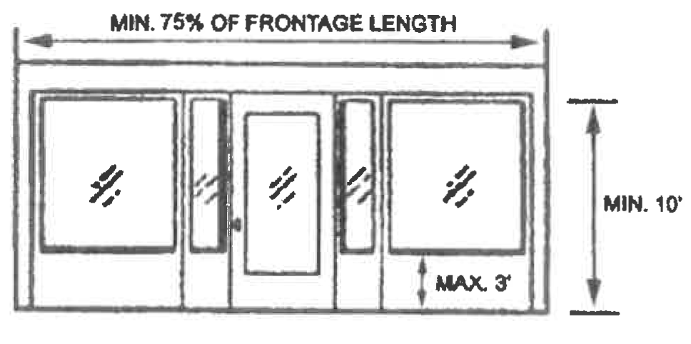
(g)
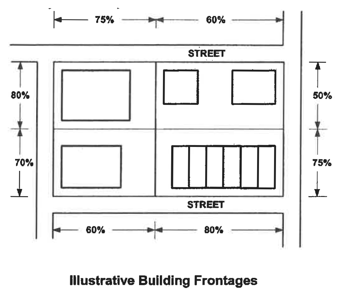
Minimum Building Frontage. The percentage of the lot's street frontage that is occupied by one or more principal buildings should be compatible and consistent with buildings on either side of the proposed building
| Consistent: Grid block pattern. Buildings are not set back much if any from streets and they frame the street frontage and street corners. Two-story height for buildings desirable. Parking is mostly behind buildings (some on-street parking is permitted). | 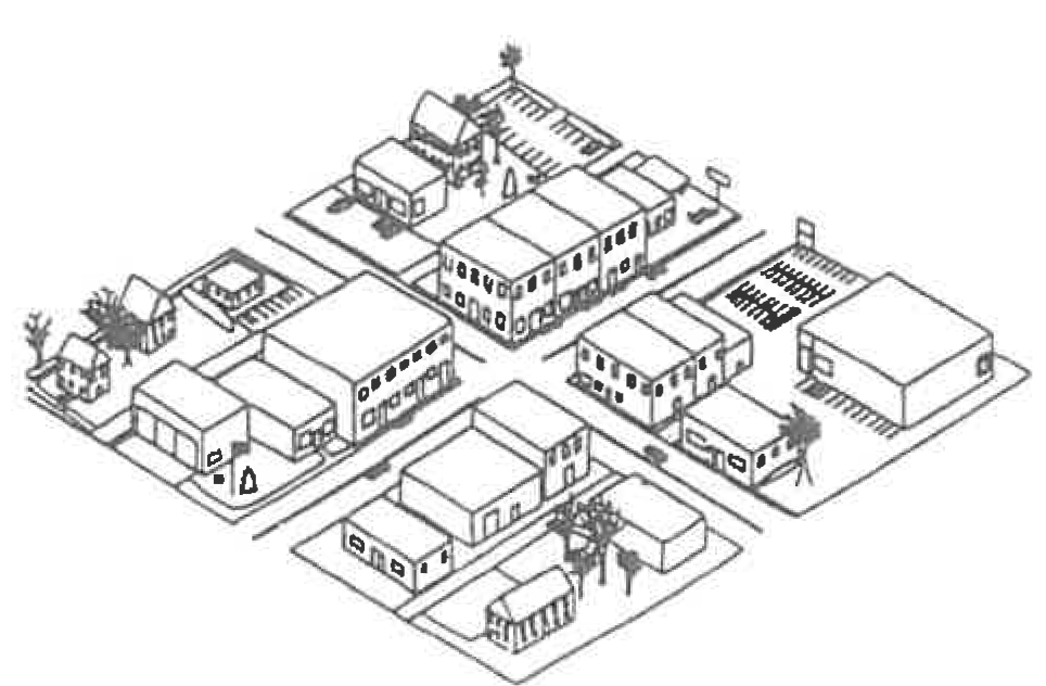 |
| Inconsistent: Mostly single-story development with parking in the front of buildings. Strip shopping center has little if any articulation (projections and recesses). Individual development sites are not coordinated with one another. | 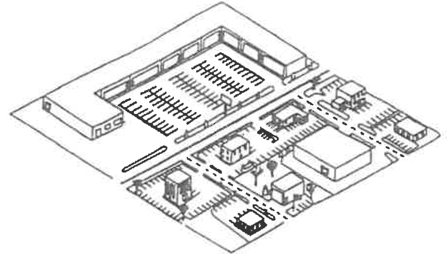 Source: Arendt, Randall, et al. Rural By Design: Maintaining Small Town Character, Figure 9-2, p. 118. (Chicago: Planners Press, 1994).
|
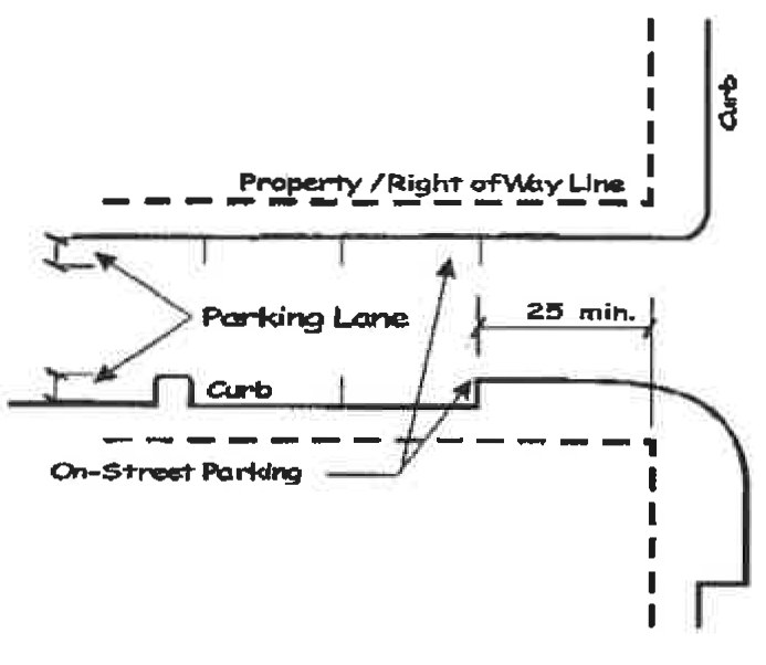
(h)
On-street Parking. On-street parking shall be permitted on all streets within Urban and Traditional Neighborhood character areas, except within twenty-five feet of the right-of-way of an intersecting street. On-street parking is required in all Urban and Traditional Neighborhood character areas designated as storefont streets.
 |  |
| Source: Kendall, Florida. Ordinance 99-166. Downtown Kendall Urban Center District. | Graphic - Source: Calthorpe, Peter. "The Regional City." In Time-Saver Standards for Urban Design, edited by Donald Watson, Alan Plattus, and Robert Shibley. New York: McGraw-Hill, p. 1.5-6. |
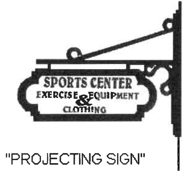
(i)
Signs. Within pedestrian retail districts, projecting signs are permitted and encouraged.
(j)
Sidewalk Clear Zone and Street Furniture Zone. In pedestrian retail areas, the street sidewalk should consist of a minimum five-foot wide (5') clear zone. Between the clear zone and street curb, there should be a five-foot wide street furniture zone for the placement of light poles, benches, bicycle parking, trash receptacles, tree planting, and planter boxes.
(k)
Pedestrian Crossings of Driveways and Intersections. The color and composition of sidewalk shall be continued as it crosses vehicular driveways and street intersections. Where the sidewalk color and composition of the sidewalk is not otherwise distinguishable from the driveway or roadway composition and color, the sidewalk shall be composed of material with color and texture that demarcates the pedestrian crossing. This provision is required to promote safety of pedestrians, as different textures or colors of pedestrian crossings alert or remind the motorist pedestrians are present.
(Ord. No. 348-17, § 1(Exh. A), 8-2-2018)
Sec. 10.9. - Activity Centers Including Automobile-Related Establishments.
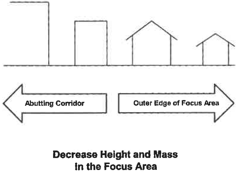
(a)
Within an activity center, a logical hierarchy of building forms should be created. Building heights and masses should be greatest in the focus area and inner portion of the support area (the part closest to the focus area) and should transition to lower heights and less mass outward from the focus area to the outer edge of the support area. Building massing should be varied to create a logical hierarchy of building forms, to break up long expanses of façade, and to create shade and shadow. Buildings at the outer edge of an activity center's support area should be comparable in height and mass with the surrounding neighborhood beyond the support area.
(b)
Building location, setbacks, and orientation should be carefully considered so as to increase pedestrian comfort.
(c)
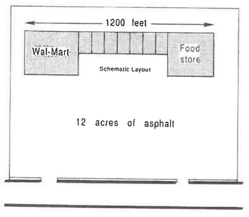
As far as practicable, buildings in activity centers should not be separated from fronting streets by large parking lots. At a minimum, placement of outparcel buildings between a large parking lot and the street should be used to help define the streetscape and lessen the visual impact of the parking lot from the street.
(d)
Provide a grid pattern of local streets. There should be at least one public or private through-street for every 600 feet of property frontage along a local road (not a state route), connecting to the local road. Smaller block widths (one per 400-500 feet) are preferred in activity center character areas. Blocks with a perimeter of 2,000 feet or less are encouraged.
(e)
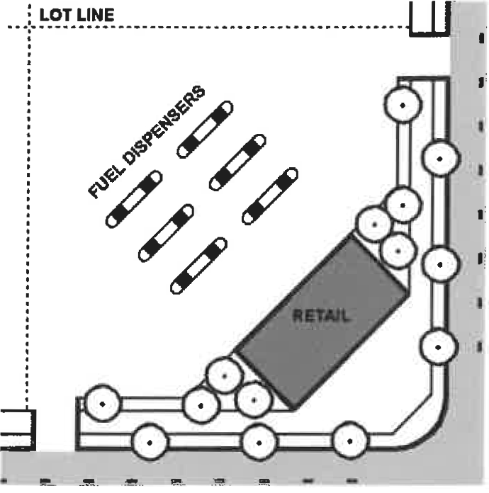
Auto service facilities should not have their service bays facing the street, and parking for all uses should be located to the side or rear of the building rather than in the front yard. Regardless, service areas and/or service bays shall be screened or sited so they are not visible from the street.
Convenience stores shall locate gas pumps behind the principal structure in order to effectively screen the pumps from view of the street.
(g)
Vehicles under repair shall be kept either inside a structure or in an area which is screened from views from the street.
(h)
Service areas shall provide adequate queuing space that does not impede vehicle circulation through the site or result in vehicles stacking into the street.
(i)
Perimeter and security fencing, when needed, should be constructed of attractive materials which are compatible with the design and materials used throughout the project. Razor wire or electric fencing shall not be used, and chain link fencing is discouraged but if used shall be black, vinyl coated.
(j)
Separate structures (canopy, car wash, cashier's booth, etc.) on the site should have consistent architectural detail and design elements to provide a cohesive project site. If a car wash is incorporated into the project, it should be well integrated into the design. The car wash opening should be sited so that it is not directly visible as the primary view from the street into the project site.
(k)
All areas devoted to the outside storage of vehicles, merchandise, and/or equipment not intended for display for public rent, lease, or sale, shall be screened from view from the right-of-way of the highway or public road along the entire property frontage, except in areas where access crossings have been approved. Screening may be accomplished by a natural vegetative buffer, by a building, by an earthen berm, by a 100 percent opaque, solid wooden fence or wall, or combination of these screening methods. The use of low-lying landscaping that does not screen the display areas from view from the public right-of-way shall not be deemed to comply with this policy.
 Source: Arendt, Randall, et al. Rural By Design: Maintaining Small Town Character, Figure 3-1, p. 28. (Chicago: Planners Press, 1994).
|  Source: Arendt, Randall, et al. Rural By Design: Maintaining Small Town Character, Figure 3-1, p. 28. (Chicago: Planners Press, 1994).
|
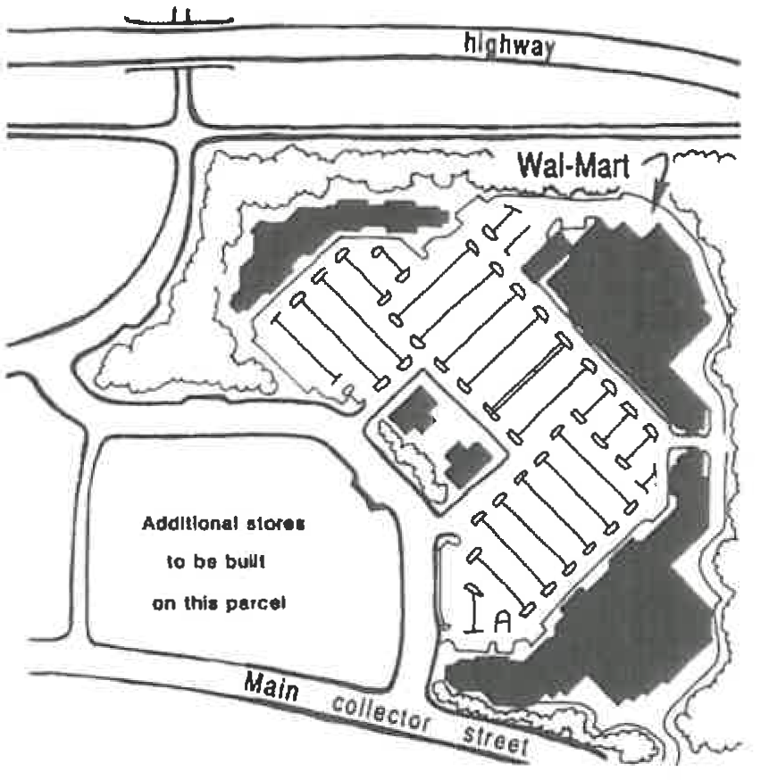
| Inconsistent: Buildings are long and not articulated. Parking provided entirely in front of the shopping center is discouraged. | Consistent: Shopping center is buffered from major highway, and access is from a collector street instead of directly onto the highway or frontage road. Parking lot is broken up by outparcel. |
| Consistent: Shopping center has highly articulated architecture, with pitched roofs and other special architectural features including stacked stone. Sign is externally rather than internally illuminated. Cut-off fixtures are used for exterior lighting of the parking lot. | 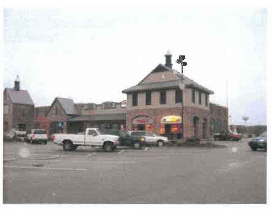 |
| Inconsistent: No landscaping in the parking lot. |
(l)
Live/Work Units. Activity centers and mixed use developments may include live/work units.
Source: Nashville, Tennessee, Metro Planning Department. 31 st Avenue/Long Boulevard Urban Design Overlay. Adopted 3/16/04. Attachment to Ordinance No. BL 2004-151.
(m)
Land Use Mix. The following guideline is provided for mixing land uses within an activity center (based on land area within the development).
(Ord. No. 348-17, § 1(Exh. A), 8-2-2018)
Sec. 10.10. - Office, Institutional, Business, and Industrial Parks and Campuses.
(a)
Buildings for institutions should be dispersed throughout the site in a campus arrangement. Substantial wooded buffer should remains along the perimeter streets, and riparian areas should remain undeveloped. Parking should be distributed throughout the site. Greens should be provided within the campus in areas likely to be used by patrons and visitors.
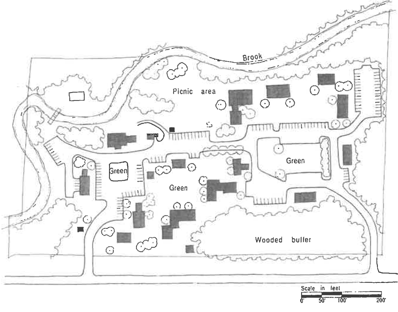
Source: Arendt, Randall, et al. Rural By Design: Maintaining Small Town Character, Figure 22-10a, p. 392. (Chicago: Planners Press, 1994).
(b)
A monument-style sign should be used to mark the entrance to the campus or park. Entrances shall be attractively landscaped, including street trees and flowers planted at the base of monument signs.
(Ord. No. 348-17, § 1(Exh. A), 8-2-2018)
Sec. 10.11. - Signage.
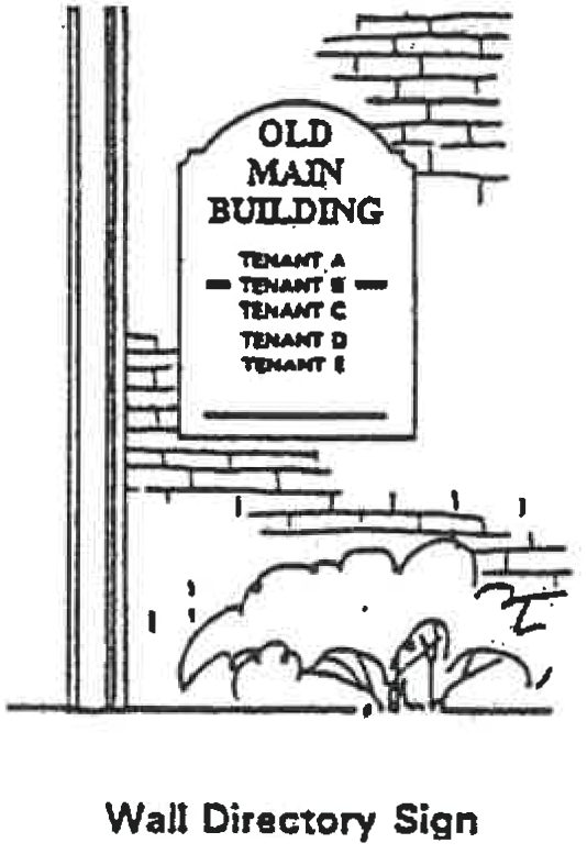
(a)
In pedestrian retail districts (Old Town and Mixed Use Character Areas), where possible, directory signs should be integrated onto buildings rather than free-standing.
(b)
Signs within locally established historic districts require review and approval by the Historic Preservation Commission.
(c)
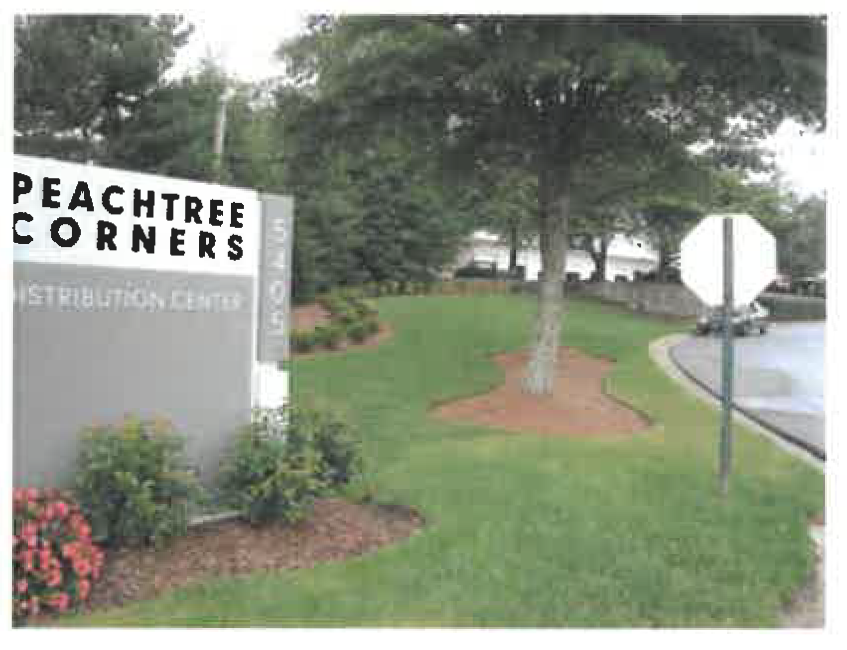
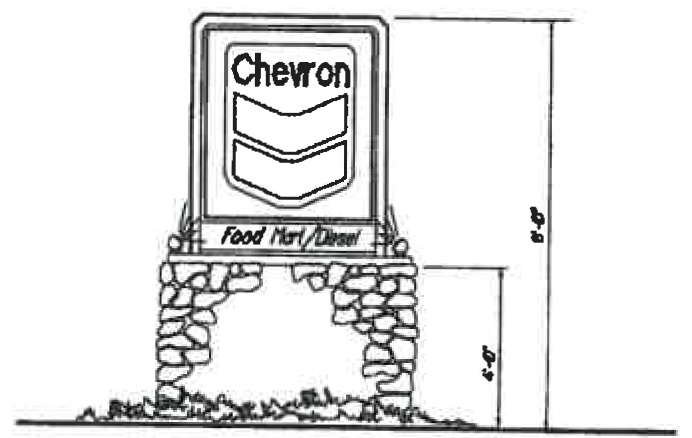
Monument signs, i.e., those with a brick or stone base, are preferred and may be required in certain character areas.
(d)
The height of signs should be kept as low as possible while still maintaining visibility by motorists. (Ord. 348-11)
![]()
(Ord. No. 348-17, § 1(Exh. A), 8-2-2018)
Sec. 10.12. - Exterior Lighting.
(a)
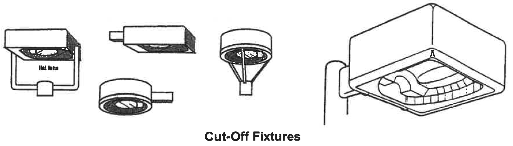
Exterior lighting should be architecturally compatible with the building style, material and colors. Galleria style and shoe box styles (cutoff fixtures) are preferred over cobra type light fixtures and directional flood lights. Fixture mounting height should be appropriate for the project and the setting. The mounting height of fixtures in smaller parking lots or service areas should not exceed twenty feet, with lower mounting heights encouraged, particularly where adjacent to residential areas or other sensitive land uses. Use of low, bollard-type fixtures, 3-4 feet in height, are encouraged as pedestrian area lighting.
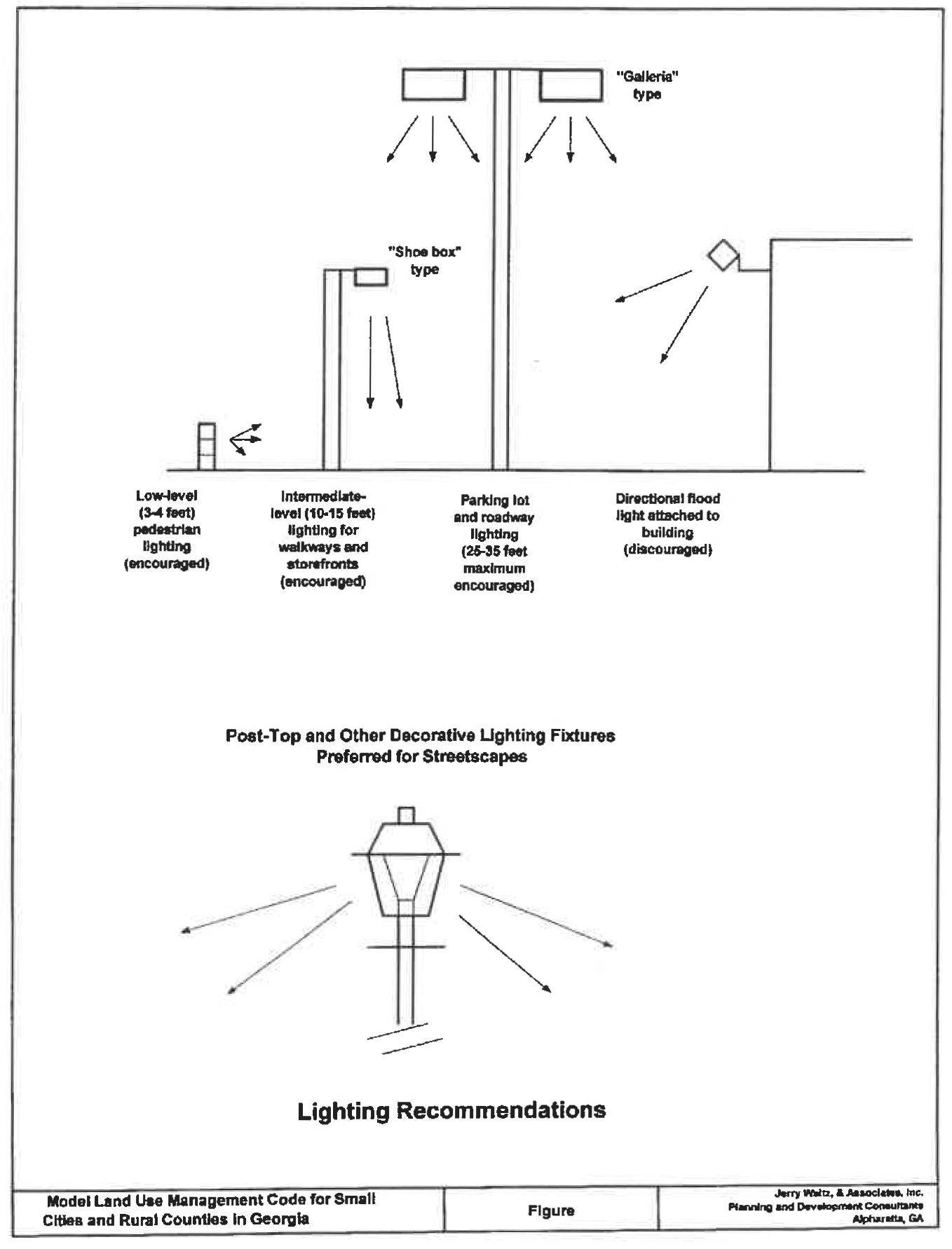
(b)
Exterior lighting of the building and site should be designed so that light is not directed off the site and the light source is shielded from direct offsite viewing. All outdoor light fixtures should be fully shielded or be designed or provided with light angle cut-offs, so as to eliminate uplighting, spill light, and glare.
(Ord. No. 348-17, § 1(Exh. A), 8-2-2018)
Sec. 10.13. - Parking Lot Landscaping.
(a)
Parking lots that face a street should be partially screened from the street by a low fence, wall, hedge, berm, or vegetated buffer. If a parking lot fronts an arterial or major collector street and is of such a size that it dominates views from the fronting arterial/collector street and detracts from the overall streetscape and community appearance, then the parking lot should be screened or buffered with vegetation in its entirety from view along the fronting roadway(s) within the required right-of-way frontage planting strip.
(b)
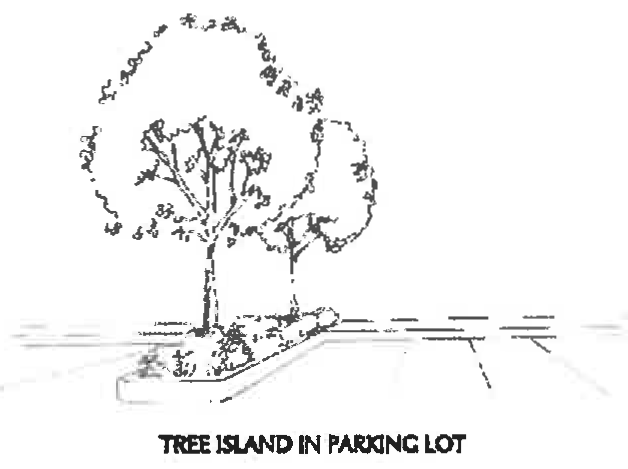
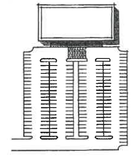
Tree wells of sufficient size to contain one canopy tree should be provided within parking areas with ten (10) or more spaces and located in such a manner so as to divide and break up the expanse of parking areas. Tree wells should be located at the end of each row of parking spaces in the interior of the parking lot. In addition, one tree well should also be provided for every 150 linear feet of parking spaces, whether at the periphery or in the interior of the parking lot.
(c)
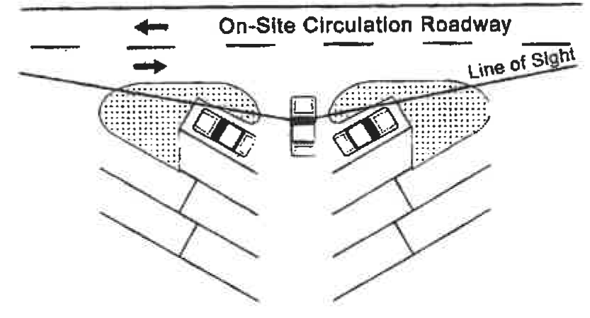
Parking Lot Landscaped End Islands. Landscaping at end islands of parking aisles shall not inhibit sight distance as required for motorist safety. Parking aisle end islands shall be curbed. Painted end islands are ineffective and are not permitted.
(d)
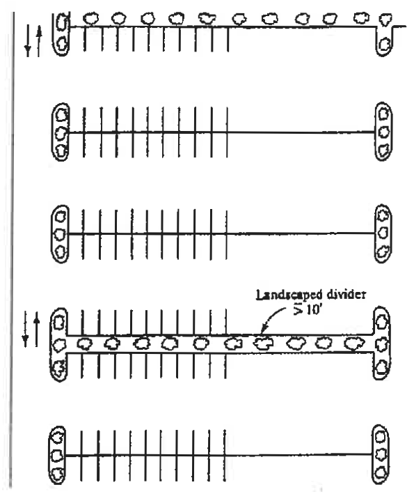
In large parking lots, landscape dividers are encouraged to be installed every fourth row of parking spaces so as to divide the expanse of the parking lot and avoid improper and dangerous circulation habits, or other acceptable means such as the staggered provision of planting islands. Where appropriate sidewalks may be installed within wide landscape dividers.
Consistent: Large parking lot is separated by curbed landscape divider with small shrubs and shade trees; shoebox style (cut-off fixture) lighting.
(Ord. No. 348-17, § 1(Exh. A), 8-2-2018)
Sec. 10.14. - Parking Lot Paving and Design for Pedestrians.
Utilizing porous pavements and grass pavers also reduces or eliminates land dedicated to surface storm water management facilities. Porous pavement designs and grass pavers are appropriate in some instances. Other types of stormwater management facilities are also more environmentally compatible, such as vegetative swales and bioretention.
Pedestrian circulation should take precedence over vehicular circulation. Where pedestrian circulation crosses vehicular routes, a change in grade, materials, textures or colors should be provided to emphasize the conflict point and improve its visibility and safety. Accent strips of brick or textured paving may also be appropriate for defining pedestrian walkways.
Consistent: Pedestrian crossing a high traffic area is marked with change in paving materials. The central aisle provides a direct connection for pedestrians.
(Ord. No. 348-17, § 1(Exh. A), 8-2-2018)
Sec. 10.15. - Noise.
(a)
Flowery Branch is bisected by Interstate 985. The potential impacts of noise on adjacent and nearby land uses is a concern, particularly for residential properties. Residential developments, if located near the interstate corridor, will need to carefully consider the potential impacts of noise on residential living conditions.
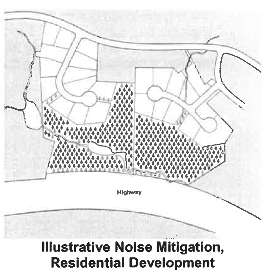
(b)
Noise analysis is performed by determining existing and future traffic noise levels for a site and surrounding areas. Noise impacts can be very subjective, since the data is dependent on the relative distance of the observer or receptor from the source of noise.
(Ord. No. 348-17, § 1(Exh. A), 8-2-2018)
Sec. 10.16. - Access Management.
(a)
Access management specifications need to be applied when existing development is modified or new buildings are added. It is desirable to limit access onto arterial roads to mostly from existing access points. For those parcels that do not currently have direct access to abutting arterials, it is desirable to provide connections to access roads as opposed to new curb cuts or access points directly onto the arterial. The necessary spacing of driveways (and roads) depends on speed limits and must account for driver perception and reaction time. On state highways, driveways are subject to Georgia Department of Transportation approval and other adopted local regulations. By providing for the connections among parcels via frontage roads and inter-parcel access easements, the number of additional access points onto arterial roads can be minimized.
(b)
Aligning access points on opposite sides of a road or highway is important in terms of vehicular safety and the economy of road construction. Aligning access points (curb cuts) on opposite sides of the roads is considered essential when the road is divided by a median and a median break occurs. The entire parcel, rather than simply a particular project, needs to be considered in formulating and approving access plans.
(c)
In the event that a subdivision or land development required to file development plans with the City has access to a city street which is an unimproved or substandard road, improvements need to be considered through a development agreement.
(Ord. No. 348-17, § 1(Exh. A), 8-2-2018)
Sec. 10.17. - Interparcel Access.
(a)
Consideration needs to be given to how each land development will connect with compatible land use developments that it abuts. In order to do so, each land development has to be planned with driveway connections across property lines, when the abutting land uses are compatible. When cut or fill is involved in the grading of an individual building pad or development site, the finished grade of the parking lot or driveway needs to be terminated far enough inside the property to allow for the slope to return to that of the natural ground at the property line.
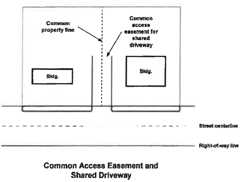
(b)
In cases where a parcel has access to a state highway or arterial street, shared driveways between two parcels, including common access easement at the property line, may be needed. In such cases, each property owner provides for and grants a common access easement to facilitate the movement of motor vehicles across the site.
Inconsistent: Single-function, separated land uses. Conventional development patterns shown here provide no connections among different land uses. In this illustration, the residential subdivisions could be, but are not, connected with a pedestrian access-way to the school site and beyond.
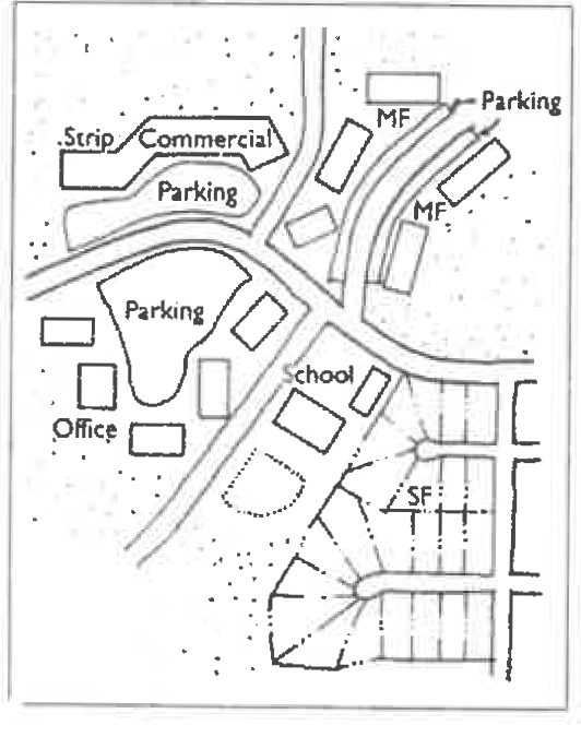
Source: Calthorpe, Peter. "The Regional City." Figure 4, p. 1.5-4. In Time-Saver Standards for Urban Design, edited by Donald Watson, Alan Plattus, and Robert Shibley. New York: McGraw-Hill, 2003.
(c)
The finished grade of any parking lot or driveway should be no more than fifteen (15) percent higher or lower than the natural ground elevation of the property at each abutting property line with frontage on the highway, to allow for driveway connections at acceptable grades. In addition to transportation benefits, proper grading at property lines also provides for a blending of the finished site elevations in a manner so that stark contrasts in the landscape will not occur and so that grading practices will be more in keeping with the natural topography.
Consistent: Inter-parcel access provided. Storm drainage located to the rear of lots. Parking is provided to the side and rear of the lot.
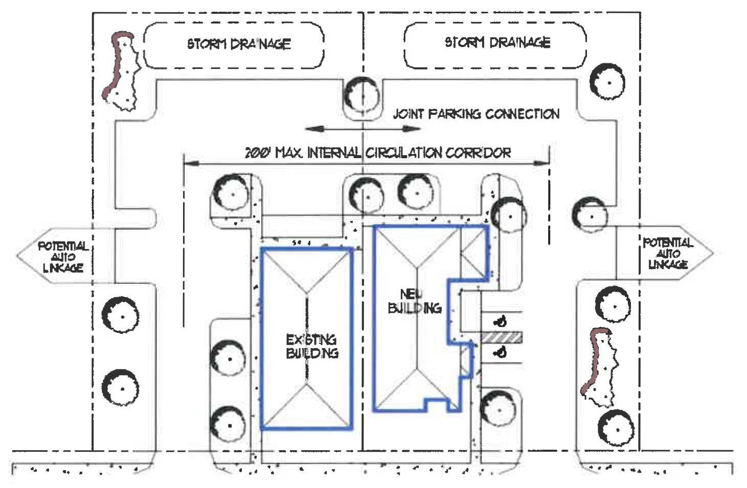
Source: Peirce County, Washington. Title 18J - Development Regulations - Design Standards and Guidelines.
(Ord. No. 348-17, § 1(Exh. A), 8-2-2018)
Sec. 10.18. - On-site Circulation Standards for Land Development.
(a)
Service functions (e.g., deliveries, maintenance activities) need to be integrated into the circulation pattern in a manner which minimizes conflicts with vehicles and pedestrians. Access for service vehicles, trash collection and storage areas need to be located on alleys where alleys exist. When no alley exists, access needs to be provided to the rear or sides of buildings being served. Larger commercial developments need to have service and loading areas separate from main circulation and parking areas.
(b)
Developers should strive to provide a 100 foot deep clear zone between the pavement of an arterial road and the first turning movement from an internal driveway. On any other road (city street) the clear zone or throat length should be at least 50 feet before a turning movement occurs (including parking), to provide sufficient queuing room for cars and/or delivery vehicles exiting the street. This provision may be modified by the Zoning Administrator after review by a Traffic Engineer or City Engineer.
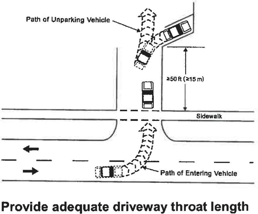
Source: Stover, Vergil G., and Frank J. Koepke. 2002. Transportation and Land Development (2 nd Ed.). Washington, DC: Institute of Transportation Engineers. Figure 7-22, p. 7-31.
(c)
Except for detached, single-family dwellings, pedestrian access needs to be provided to individual developments and each establishment within the development. Pedestrian ways need to be well defined, take as direct a path as possible, and they separated where practical from automobile access ways. Parking aisle dividers are appropriate locations for pedestrian access facilities.
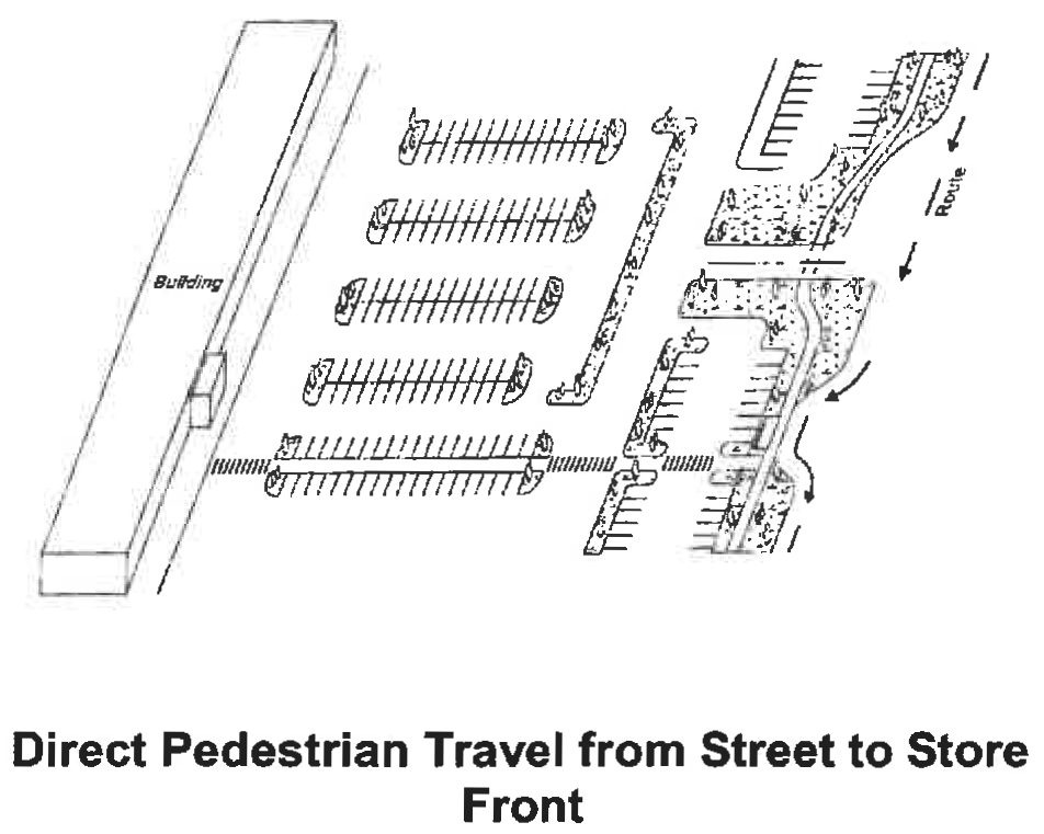
Source: Stover, Vergil G., and Frank J. Koepke. 2002. Transportation and Land Development (2 nd Ed.). Washington, DC: Institute of Transportation Engineers. Figure 8-28, p. 8-35.
(Ord. No. 348-17, § 1(Exh. A), 8-2-2018)
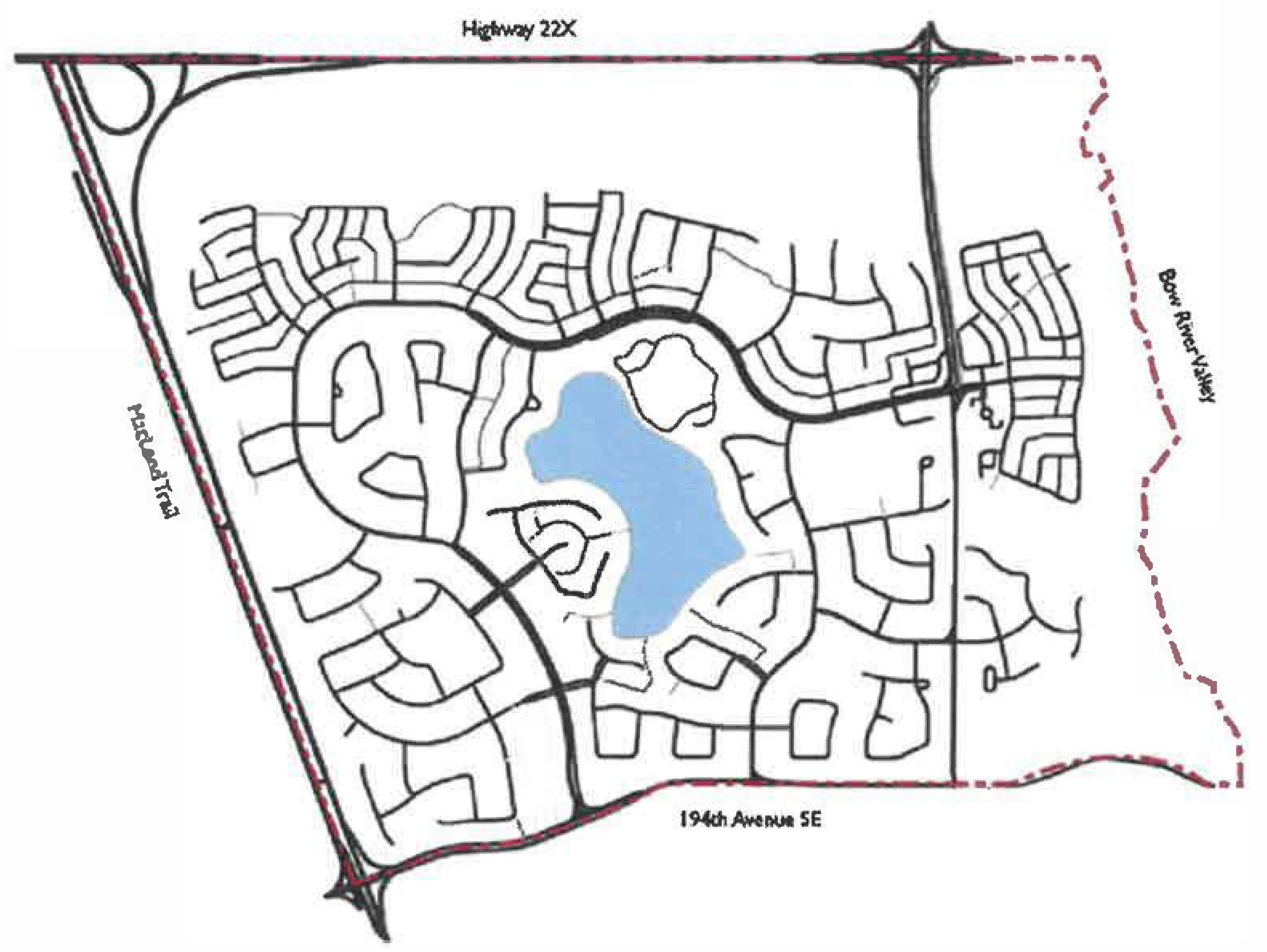
Sec. 10.19. - Extension of Downtown Street Grid.
To ensure compatibility with the unique street grid pattern in Flowery Branch's downtown, development in and near the downtown core should be served with adequate road capacity, pedestrian-friendly design features, good connectivity, and improved streetscapes. From a town planning standpoint, the small block pattern found in the center of downtown should be extended as more dense, urban development proceeds outward.
(Ord. No. 348-17, § 1(Exh. A), 8-2-2018)
Sec. 10.20. - Traffic Impact Studies.
A traffic impact study for developments may be requested by the City when appropriate.
(Ord. No. 348-17, § 1(Exh. A), 8-2-2018)
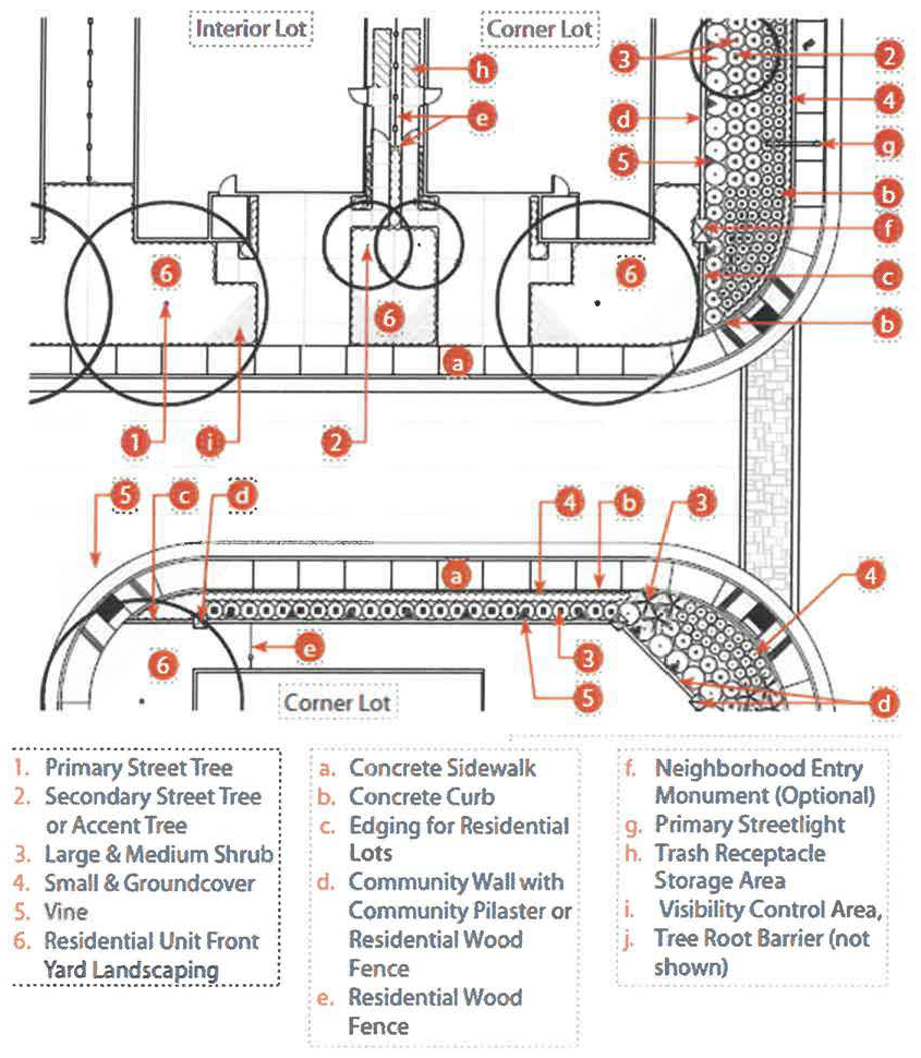
Sec. 10.21. - Residential Street Design Requirements.
(a)
General Landscaping Standards for Streets. The following is a list of general landscaping standards for all street landscaping. A full, detailed plan for the entire community must be submitted and approved as part of the land disturbance/civil plans.
1.
Landscape Area grading and slopes shall not exceed 5:1 for turf areas and 4:1 for planting areas. If Landscape Area grading or slopes exceed these rations, a retaining wall shall be required. All retaining walls over 4 feet in height shall be reviewed and approved by the City.
2.
The minimum planting size for a tree shall be 15-gallon, with two-third (⅔) of all trees being 2" caliper or larger.
3.
All street trees shall be selected from the approved City list.
4.
Street Trees shall be located every 25' on center spacing.
5.
Secondary Trees or Accent Trees shall occur in informal groupings of three or five trees of the same species, planted between the sidewalk and adjacent land use property line. Mixed massings of flowering trees and evergreen species are required.
6.
Street Trees and Secondary Trees or Accent trees shall be a combination of deciduous and evergreen trees for purposes of screening and creating seasonal change. A minimum of 30 percent of the Street Trees and Secondary or Accent trees on a particular street shall be evergreen species.
7.
All trees planted within 10 feet of a street, sidewalk, paved trail, walkway or plaza element shall be separated by a tree root barrier to prevent damage to public improvements and private property. The tree root barrier shall be installed at time of planting of the tree.
8.
A minimum distance of 10 feet is required between the center of a tree and all light standards.
9.
Shrub plantings adjacent to walls and fences shall be group massings, layered to provide visual interest. Variety in height is required. Multiple rows of layered plantings are encouraged where space is adequate.
10.
All shrub planting (i.e., small, medium, large) along any Landscape Corridor and intersections containing entry monuments shall be a minimum of 5-gallons in size. When shrubs are planted to serve as a hedge or screen, the shrub shall be planted at a spacing relative to the plant species' mature width (a shrub with a four-foot-wide mature width shall be planted at four feet on center). Plants that are not commercially available in a 5-gallon size, may be substituted with a 1-gallon size.
11.
When a particular size plant is specified across large sections of the proposed landscape plan, (i.e., medium shrub), the landscape architect shall use alternating groupings of plants to achieve a planting design that has different genus and species along the entire streetscape. This shall be done to prevent a monolithic plant palette extending along the street.
12.
All groundcover planting shall be 1-gallon or grown in flats of up to 64 plants. Root cuttings from plants shall not be located greater than 12 inches on center spacing. Containerized 1-gallon groundcover plants shall not be located greater than 3' on center spacing.
13.
Groundcover plantings shall be located between all separated sidewalks and back of curb/right-of-way ("ROW") along all publicly maintained Landscape Corridors, or as determined by the City.
14.
A 3" layer of walk-on type bark mulch shall be located in all planter areas around trees, shrubs and groundcover within all Landscape Corridors.
15.
Locations of colored concrete enhanced paving shall be submitted and evaluated at the entitlement stage of each development project.
16.
All bulbouts shall be planted in a combination of shrubs and groundcover, and/or concrete paving as applicable to adjacent land use.
17.
All tree grates shall be located at back of curb. Tree guards shall not be installed.
(b)
Specific Residential Street Landscaping Requirements.
1.
Primary Residential Street.
Primary Residential Streets provide access into and through the neighborhoods. When single-family residential houses back onto the street, a Community Wall is required at the property line and an additional 8 foot Landscape Area shall be required to provide screening of the Community Wall. In this application, all landscape improvements including the 8 foot Landscape Area and the landscaping within the separated sidewalk shall be considered public improvements and shall comply with all City requirements. When single-family residential houses fronts the street, the entire Landscape Area on that side of the street shall be private landscaping designed to the City's satisfaction and maintained by the landowner.
2.
Local Residential Street.
Local residential streets provide access into and through neighborhoods. Only residential houses will front a local residential street. Therefore, all landscape improvements shall be private landscaping designed to the City's satisfaction and maintained by the landowner.
3.
Corner Lot Landscaping Requirements.
Residential corner lots are a critical component to the overall theme of a community. The individual residential unit improvements specified in this section are outside of the ROW for each associated street. Therefore, all landscape improvements shall be private landscaping designed to the City's satisfaction and maintained by the landowner. The standards in this chapter regarding corner lot landscaping are the minimum requirements. The builder/designer may deviate from the planting design as long as the design consistency is preserved throughout the community. Any deviation to the planting design shall be approved by the City.
(c)
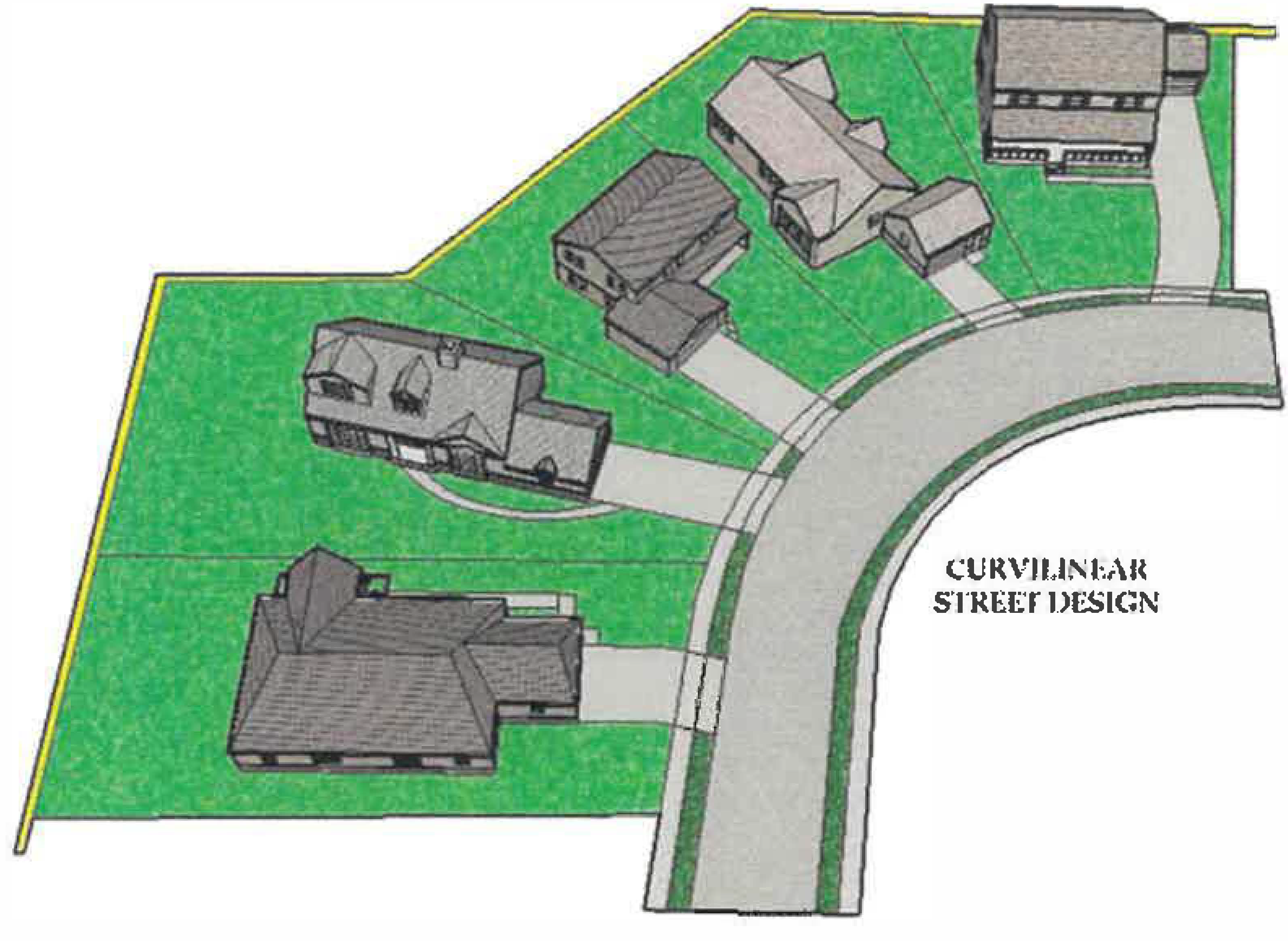
Residential Street Design Requirements. All new residential streets shall be curvilinear. All streets more than 360 feet in length shall have at least 25 feet of lateral deviation from a straight course.
(Ord. No. 694, § 1(Exh. A), 6-1-2023)
Sec. 10.22 - Open Space Requirements.
(a)
Defined. Open space is the horizontal outdoor area of a site reserved to provide separation, resource protection, scenic enjoyment, recreation, or amenity. It includes two types: civic space and amenity space.
(b)
Minimum Requirements.
•
New developments with a mix of residential and non-residential uses shall satisfy both requirements independently.
(c)
Development.
•
Restaurants with one or more exterior walls shall be subject to the following additional requirements:
1.
An outdoor dining area equal to at least 10 percent of the restaurant floor area shall be provided. When the outdoor dining area conforms to this Section it may be counted towards amenity space requirements.
2.
When the restaurant abuts a public street (including across an intervening parking lot) the required outdoor dining area shall be located along the portion of the façade facing such public street.
3.
The Director of Community Development has the authority to authorize the required outdoor dining to be placed in locations other than required by (b) above when:
a.
There is insufficient area between the restaurant and the street to accommodate all the required outdoor dining; or
b.
There are other unique circumstances not created by the applicant than render this requirement unfeasible.
•
Civic Space. Civic space is the portion of open space for public use defined by the combination of certain physical constants including the relationships among their intended use, their size, their landscaping, and their adjacent buildings. Above-ground cistern design and appearance shall require approval by the Director of Community Development.
1.
Park. An open space available for structured or unstructured recreation. A park may be independent of surrounding buildings at its edges. Its landscape may consist of paths and trails, meadows and lawns, water bodies, runoff reduction measures such as bioretention areas, swales, cisterns, and woodlands. Recreation fields and courts may also be included. The minimum size for a park is one acre.
2.
Square. An open space available for unstructured recreation and civic purposes. A square is spatially defined by building or streets at its edges. Its landscape must consist of paths and trees and may also include runoff reduction measures such as bioretention areas and cisterns, lawns and non-asphalt paved surfaces. The minimum size for a square is one-half acre.
3.
Plaza. An open space, available for civic purposes and commercial activities. A plaza must be spatially defined by building or streets at its edges. Its landscape must consist primarily of non-asphalt paved surfaces and trees, and may include runoff reduction measures such as bioretention areas and cisterns. The minimum size for a plaza is one-quarter acre.
4.
Pocket Park. An open space, available for unstructured recreation. A pocket park may be spatially defined by buildings or streets at its edges. Its landscape must consist of lawn and trees and may include runoff reduction measures such as bioretention areas and cisterns. There is no minimum size for pocket parks.
5.
Playground. An open space designed and equipped for the recreation of children. A playground must be fenced and may include an open shelter. Playgrounds must be interspersed within residential areas, may be placed within a block, and may be included in parks and greens. There is no minimum size for playgrounds. Playgrounds may include runoff reduction measures such as bioretention and underground detention.
6.
Performance Venues. An open space available for outdoor performances. Performance venues typically include a stage surrounded by formal or informal seating on at least one side. Performance venues may have a combination of landscaped and hardscaped areas. The minimum size for a performance area is one-half acre.
7.
Multi-Use Trails with Potential Connections to Offsite Trails. A linear open space consisting of a conforming multi-use trail that includes a connection to existing or proposed off-site trails. There is no minimum size for this type of open space.
8.
Park Overlooks. An open space primarily intended for the viewing of parks and other open spaces. Park overlooks must include seating. There is no minimum size for park overlooks.
•
Amenity space. Amenity space is the covered or uncovered, but unenclosed, outdoor areas of at least 100 square feet each for use by the occupants, invitees and guests of the development and specifically excluding Civic Spaces and required sidewalks. Amenity spaces may include, but are not limited to:
1.
Rooftop decks;
2.
Balconies (min. 6' x 8');
3.
Patios and porches;
4.
Outdoor dining areas;
5.
Pool areas;
6.
Tennis courts, basketball courts, and similar uses;
7.
Yards, lawns, and flower gardens;
8.
Community gardens;
9.
Hardscape areas improved for pedestrian enjoyment;
10.
Wooded areas; and
11.
Runoff reduction measures such as bioretention areas and cisterns.
Each amenity area approved must be available and accessible as exterior space appropriately improved for pedestrian amenity or for aesthetic appeal, subject to approval by Director of Community Development. Above-ground cistern design and appearance shall also require approval by the Director.
•
Open space requirement may be met using existing and/or new open space, subject to approval of the Director of Community Development.
•
Open space may be privately, or publicly owned. Private open space is open space that is owned by a corporation, individual, or homeowners' association. Public open space is open space owned by a governmental agency.
•
Wetlands, lakes, ponds, streams, rivers, flood zones, and stream buffers may only be considered open space when located within one of the eight types of civic spaces identified in Section 2.10.C or within an amenity space that conforms Section 2.10.10.D, unless part of an approved stormwater management plan for the site that includes runoff reduction measures.
•
No required buffer may be used to satisfy open space requirements, except for stream buffers that are improved with trails and other authorized amenities.
•
Stormwater management facilities for the site may be used to satisfy open space requirements if they meet this Chapter's definition of open space. Open space credit may be given at the discretion of the Director of Community Development.
•
No areas used for vehicles, except for incidental service, maintenance, or emergency actions, may be used to satisfy open space requirements.
(Ord. No. 694, § 1(Exh. A), 6-1-2023)